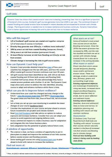
Dynamic Coast. Coastal erosion / Management Briefing to THC
|
|
|
- Beverly George
- 5 years ago
- Views:
Transcription


1 Dynamic Coast Coastal erosion / Management Briefing to THC
2 What is Dynamic Coast? Dynamic Coast is a Scottish Government project, funded by CREW, managed by SNH, with a research team from the University of Glasgow. It provides a publically available evidence base of changes to Scotland s erodible coastline, to inform better decision making to improve the resilience of our coastal infrastructure, assets, businesses and communities. Dynamic Coast includes the National Coastal Change Assessment phase 1 & 2. 2


3 Climate change is affecting Scotland s erodible coast 3 Since 1970s: 22% extent of accretion, 39% extent of erosion, and x2 of erosion rates. Golspie, 2014


4 Nature s defences protect more than ours do Within 50m of MHWS 13bn protected by natural defences 5bn protected by sea walls


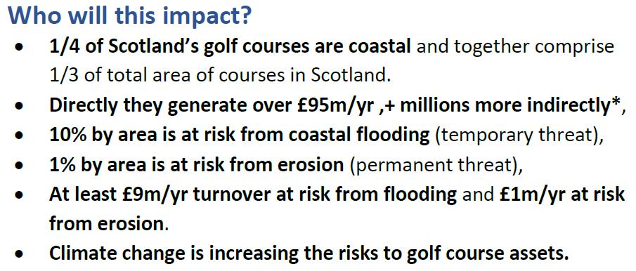
5 At least 240m of assets are at risk in next 30 years if recent erosion continues Runways Rail, Road & Water Property Water, Road & Prop. 5 All sectors are at risk within all coastal cells (buildings, roads, rail, runways, water supply, cultural & natural heritage).


6 These are likely to be underestimates Future Historic period Recent period Not just sea level rise: Storm freq., Human factors etc are also relevant. Vulnerability assessment (ie 240m) based on past rates rather than faster future rates & erosion expanding into adjacent areas. Flooding & erosion expected to increase significantly. In many areas asset damage is not imminent, but we must start to plan now. 6


7 Why is this important? erosion enhanced flooding is one of the key ways climate change will be manifested. SLR will have big impact on flood frequency. M.E.S. Leith +0.3 m of sea level by 2090 = 1:100 yr event 1:8 yr (1% or 12.5% probability) 7

8 We have a window of opportunity to prepare mitigation, adaptation and resilience plans Dynamic Coast gives Scotland it s most advanced, nationally consistent and locally informed understanding of the causes and consequences of coastal change that it has ever had, so we have to use it and build on it now. Environment Secretary Roseanna Cunningham (August 2018) 8


9 Evidence base available to all 9 Maps of all beaches (past, recent and anticipated change), 21 reports & summaries, guidance and videos
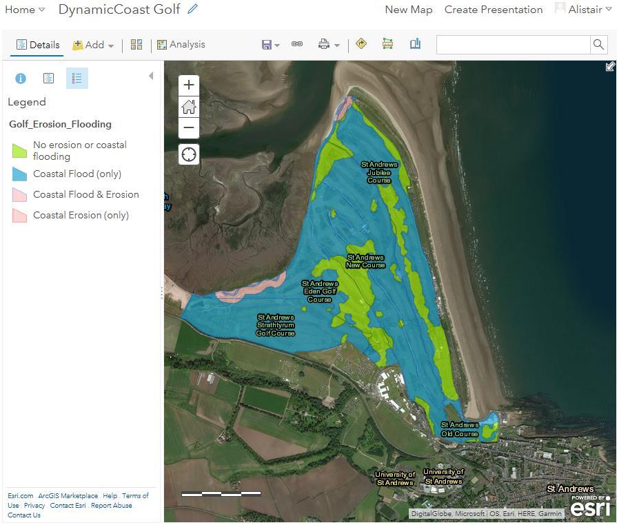
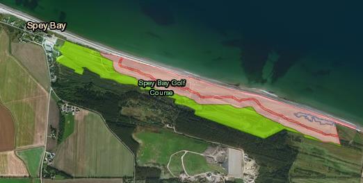
10 What where the methods? Geo-rectified historical maps Semi-automated extraction of tide lines 1 million points on the 3 shorelines Semi-automated calculation of distance between points Analysis of change Future projection where change is real Vulnerability Assessment (what is at risk) Whole Coast Assessment (what is elsewhere) Publish results online via AGOL, website & reports 10 St Andrews

11 What where the methods? Geo-rectified historical maps Semi-automated extraction of tide lines 1 million points on the 3 shorelines Semi-automated calculation of distance between points Analysis of change Future projection where change is real Vulnerability Assessment (what is at risk) Whole Coast Assessment (what is elsewhere) Publish results online via AGOL, website & reports 11
12 What where the methods? Geo-rectified historical maps Semi-automated extraction of tide lines 1 million points on the 3 shorelines Semi-automated calculation of distance between points Analysis of change Future projection where change is real Vulnerability Assessment (what is at risk) Whole Coast Assessment (what is elsewhere) Publish results online via AGOL, website & reports 12

13 What where the methods? Geo-rectified historical maps Semi-automated extraction of tide lines 1 million points on the 3 shorelines Semi-automated calculation of distance between points Analysis of change Future projection where change is real Vulnerability Assessment (what is at risk) Whole Coast Assessment (what is elsewhere) Publish results online via AGOL, website & reports 13

14 Results 37% of coastal roads are on soft coast, Almost 5x more than defended shores, Same number of buildings behind soft coast as defended shore & 5km of roads at risk in next 30 years. Whole Coast Assessment Results e.g. 156km of roads lie within 10m of MHWS, 53km on soft Asset / Receptor Unit All Hard & Mixed Within 10m of MHWs Coastal Type Soft Artificial Erodable (UPSM40+) Within 50m of MHWS Coastal Type Hard & Mixed Community Services Non Residential Property ,045 4,393 2,309 2,343 5,101 Residential Prop # ,449 9,966 7,194 7,289 15,276 Septic Water Tanks , Utilities Rail Roads km , Clean Water Network Cultural Heritage , Environment ha 4,204 2,575 1, ,790 23,430 14,873 8, ,615 Runway All Soft Artificial Erodable (UPSM40+) 14


15 Highland Council Results 1/3 of Scotland s beaches and salt marshes are within THC area, The soft coast protects important assets: road, rail, businesses & community assets, 152 km effected by erosion (ca. Inverness to John O Groats same % as Nat. Average) 110 km accretion (less than national average, not likely to improve) Since 1970s: More erosion, less accretion, rate of erosion x2 to 1 m/yr on average. Residential property Non-Res. property Septic Water Roads Roads Clean water network Clean water network Rail Rail Cultural heritage Natural heritage unit # # # # m # m # m # # At risk , Adjacent , , , e.g. Kylerhea, Kilmuir Loch Eil, Durness A9 Evanton, Kyle of Durness, Kinlochbervie, Beauly Firth, Beauly Firth, Sandwick, Loch Eil Loch Eil & Beauly Firth Dunrobin Gardens Morrich More & Loch Fleet


16 Designed for partnership working 16 SNH, SEPA, HES, Local Authorities (N&S Ayrshire, Montrose, Highland etc) ClimateReadyClyde
17 Policy areas The Climate Change (Scotland) Act (2009) requires the development of an Adaptation Programme. The Adaptation Programme takes forward the necessary work identified in Scotland by the UK Climate Change Risk Assessment. Under the Climate Change (Scotland) Act (2009), public bodies have duties to help deliver the Adaptation Programme. UKCCRA Risks (2012): increased coastal flooding, erosion and loss of coastal features Maps of past erosion, current state and future erosion conditions are required. UKCCRA2 (2016) more research to consider risks to communities, businesses and infrastructure from coastal flooding and erosion. It also highlighted accelerated rates of coastal erosion putting increasing lengths of the UK rail network at risk, as well as sea walls that protect coastal settlements SCCAP(2014) Action to adapt to the changing climate is required across society. Many actions are most appropriately undertaken at a local level, where impacts will primarily be felt. 23 Actions. 17
18 Policy areas NPF Adaptation requirements will need to be wide ranging Planning authorities have a role to play within cross-boundary and multi-sectoral working.. As they emerge, we expect flood risk management plans to become an integral part of strategic and local development planning SPP (2014) states that: the planning system should support an integrated approach, where terrestrial and marine planning overlaps. Policies and decisions should support climate change mitigation and adaptation. New developments requiring coastal defenses should generally not be supported. Development plans should identify areas at risk and areas where managed realignment would be beneficial. A precautionary approach to flood risk should take account of the predicted effects of climate change. Local Development Plans state that new development sites should not be at risk from coastal erosion. 18
 2.")
 3.")

19 Next steps? Dynamic Coast (phase 2) 1. Where are nature s defences & how resilient are they? Analyse the topography of our erodible coast to evaluate resilience & find breach points. (National) 2. Climate change accelerations Appreciate the implications of climate change on the extent and rate of erosion. How much should we increase the 240m estimate of damage due to climate change? (National) 3. Improved monitoring Improved understanding of change of vegetation edge monitoring & historical photographic surveys (10 sites) 4. Develop Resilience & Adaptation Plans at 7 Super Sites Understand past 3D change at Super Sites alongside distribution of assets. Project future change and consider implications, then develop plans to mitigate and or adapt to risks. 5. Increase adaptation awareness Provide bespoke risk summarise for key partners 6. Social Vulnerability to coastal erosion Investigate the societal vulnerability to anticipated coastal erosion to produce a Coastal erosion disadvantage map of Scotland. 19


20 Vegetation edge Remote sensing & ground survey add extra change intelligence 20
21 Collaboration Super Site Golspie links Spatial planning for Climate Change 21
22 Questions? Special thanks to our funders:
23 Why is this important? erosion enhanced flooding is one of the key ways climate change will be manifested. Sea level rise 3-6 mm/yr & rising for 21 st C Flood Frequency 1% to 18% by 2050* Recovery time 23 Coastal Processes Observations Response Sediment supply Storm Impact Coastal erosion Coastal flooding Adaptation planning essential to avoid higher costs * Already started Ball et al cm SLR for Leith by 2050 turns 1:100yr event into 1:8yr (UKCP09 High Emission Scenario 95% level for Leith & Defra (2012) UKCCRA for Scotland )
24 Implications for businesses: Sector Summary (Draft) GOLF 24


25 1a. Erosion enhanced flooding: Identify natural features the removal of which may increase flood or erosion risk. Tiered approach: Hard & Artificial coast excluded, leaving soft coast ID low-lying coast (containing 1:1,000yr flood level?) Start supersite coasts to develop workflows, then roll out across other DTMs. What is the implication of erosion enhanced flooding? 25

26 1a. Erosion enhanced flooding: Identify natural features the removal of which may increase flood or erosion risk. 26
27 1a. Erosion enhanced flooding: Identify natural features the removal of which may increase flood or erosion risk. Extract coastal cross-sections from DTMs and develop automated approaches to characterise the morphometric properties of the natural defences (width, height, volume) Where time-series data exists, identify where protective function is being lost. 27
28 1a. Erosion enhanced flooding: Identify natural features the removal of which may increase flood or erosion transects what are the: heights, widths, cross-sectional area above key altitudes? Metrics tagged to transects, for assimilation and further analysis including inland flooding extents if features were removed. 28

29 1a. Erosion enhanced flooding: Identify natural features the removal of which may increase flood or erosion risk. Factors to be established: Design of spatial database for results Transect spacing Which key levels: LAT, MLWS, MT, MHWS, HAT, T:1, 10, 100, 200, 200cc etc? Wave overtopping risk? External pressure (Sedi. Supply etc) 29


30 1a. Erosion enhanced flooding: Identify natural features the removal of which may increase flood or erosion risk. Maximise impact of results: How to link with NFRA2 Building with Nature? 30
21 st Century Coastal Adaptation - Can Scotland Deliver?
 21 st Century Coastal Adaptation - Can Scotland Deliver? Present day significant erosion in Scotland More than 10m of erosion or faster than 0.5m/yr www.dynamiccoast.com Jim Hansom 1, Alistair Rennie 2,
Scotland s centre of expertise for waters. Dynamic Coast - National Coastal Change Assessment: Defence Asset Database
 Scotland s centre of expertise for waters Dynamic Coast - National Coastal Change Assessment: Defence Asset Database Scotland s centre of expertise for waters Published by CREW Scotland s Centre of Expertise
Natural Susceptibility to Coastal Erosion: Methodology and Mapping Summary
 Natural Susceptibility to Coastal Erosion: Methodology and Mapping Summary. Introduction The Flood Risk Management (Scotland) Act 2009 (FRM Act) introduced a coordinated and partnership approach to how
Scenarios for the NI coast in the 21 st Century
 Scenarios for the NI coast in the 21 st Century Prof Julian Orford Geography, Archaeology & Palaeoecology Queen s University, Belfast Challenging perspective Living by the coast is good for your health!
Protecting the Storm Damage Prevention and Flood Control Interests of Coastal Resource Areas
 Protecting the Storm Damage Prevention and Flood Control Interests of Coastal Resource Areas Presented by: Massachusetts Department of Environmental Protection & Massachusetts Office of Coastal Zone Management
Sea Level Space Watch: Service Offering
 Space for Smarter Government Programme Sea Level Space Watch: Service Offering General Sea Level Space Watch : Operational service developed to support national flood defence planning. Systematically updated
Flood Risk Mapping and Forecasting in England
 Flood Risk Mapping and Forecasting in England Mark Franklin Environment Agency, England NORDESS Workshop on Risk Assessment and Acceptable Risk Outline Flood risk in England Who we are and how we work
Addendum to the Essex and South Suffolk Second Generation Shoreline Management Plan
 Addendum to the Essex and South Suffolk Second Generation Shoreline Management Plan September 2012 CONTENTS 1. Introduction 1 2. Changes in saltmarsh habitat 1 3. Preferred managed realignment policy options
Spatial Planning & Climate Change
 Spatial Planning & Climate Change A GRIP Approach Joseph Scott, Glasgow & Clyde Valley Strategic Development Plan Authority, Scotland Today s presentation Context Spatial Planning & Climate Change Exploring
Redcliffs Park Coastal inundation and coastal erosion
 48 Hereford Street Christchurch 8013 Attention: Deb Taylor Dear Deb 1 Introduction The (MoE) are looking to relocate Redcliffs School to a new school development at and are currently undertaking their
Adaptation to Sea Level Rise A Regional Approach
 Adaptation to Sea Level Rise A Regional Approach Project Partners: in Saco Bay, ME Peter Slovinsky, Marine Geologist Maine Geological Survey, Department of Conservation Project Funding from: Saco Bay Hazards
Presentation Outline. Project Overview. Sea Level Rise Assessment & Decision Tools. Community Engagement. Tina Whitman, Friends of the San Juans
 Healthy Beaches for People & Fish Sea Level Rise Adaptation Tools for San Juan County, WA Tina Whitman & Andrea MacLennan December 10, 2015 Presentation Outline Project Overview Tina Whitman, Friends of
Sea Level Rise and the Scarborough Marsh Scarborough Land Trust Annual Meeting April 24, 2018
 Sea Level Rise and the Scarborough Marsh Scarborough Land Trust Annual Meeting April 24, 2018 Peter A. Slovinsky, Marine Geologist Maine Geological Survey Funded by: 50% 40% Figure modified from Griggs,
A Detailed First Pass coastal hazard assessment for a long complex coast: Kingborough LGA, Tasmania
 A Detailed First Pass coastal hazard assessment for a long complex coast: Kingborough LGA, Tasmania Chris Sharples & Paul Donaldson University of Tasmania September 2012 Kingborough LGA, south-eastern
SHORELINE MANAGEMENT PLAN FOR OWEN ANCHORAGE AND COCKBURN SOUND SHORELINE MONITORING PLAN
 SHORELINE MANAGEMENT PLAN FOR OWEN ANCHORAGE AND COCKBURN SOUND SHORELINE MONITORING PLAN CHAPTER EIGHT OF DOCUMENT: LONG-TERM SHELLSAND DREDGING, OWEN ANCHORAGE ENVIRONMENTAL MANAGEMENT PROGRAMME JUNE
Seaton to Seaton Hole SUMMARY OF PREFERRED PLAN RECOMMENDATIONS AND JUSTIFICATION
 Location reference: Policy Unit reference: Plan: Seaton to Seaton Hole 6a29 and 6a30 SUMMARY OF PREFERRED PLAN RECOMMENDATIONS AND JUSTIFICATION The large number of properties and assets at risk in the
RISC-KIT: EWS-DSS Hotspot Tool
 RISC-KIT: EWS-DSS Hotspot Tool Robert McCall Ap van Dongeren Deltares www.risckit.eu This project has received funding from the European Union s Seventh Programme for Research, Technological Development
TOWARDS CLIMATE-RESILIENT COASTAL MANAGEMENT: OPPORTUNITIES FOR IMPROVED ICZM IN BELIZE
 TOWARDS CLIMATE-RESILIENT COASTAL MANAGEMENT: OPPORTUNITIES FOR IMPROVED ICZM IN BELIZE CHANTALLE SAMUELS Coastal Zone Management Authority and Institute The Caribbean Community Climate Change Centre VULNERABILITY
Scotland s centre of expertise for waters. Dynamic Coast - National Coastal Change Assessment: Methodology
 Scotland s centre of expertise for waters Dynamic Coast - National Coastal Change Assessment: Methodology Scotland s centre of expertise for waters Published by CREW Scotland s Centre of Expertise for
Storm Surge/Coastal Inundation State of the Union. Jamie Rhome Storm Surge Team Lead NOAA/National Hurricane Center
 Storm Surge/Coastal Inundation State of the Union Jamie Rhome Storm Surge Team Lead NOAA/National Hurricane Center 2 Tampa: Cat 5 Scenario 3 4 The Stakes are High Combination of SLR and increasing coastal
Numerical models in context of coastal climate change, adaptation and protection schemes. Nils Drønen Head of Innovation, CED, DHI
 Numerical models in context of coastal climate change, adaptation and protection schemes Nils Drønen Head of Innovation, CED, DHI Agenda Introduction How can we quantify coastal response to climate change
Coastal Erosion & Climate Change: PRIDE 2005 Towards an Alaska Wind/Wave Climatology
 Coastal Erosion & Climate Change: PRIDE 2005 Towards an Alaska Wind/Wave Climatology 2 nd PRIDE Workshop August 9-10, 2005 David Atkinson, Int l Arctic Research Center, Univ. Of Alaska-Fairbanks James
SOUTHEAST COASTAL ASSESSMENT: Creating a shared vision
 SOUTHEAST COASTAL ASSESSMENT: Creating a shared vision November 12, 2017 Jacqueline Keiser, PG, PMP Regional Sediment Management Regional Center of Expertise SOUTH ATLANTIC DIVISION U.S. ARMY CORPS OF
Weather Climate Science to Service Partnership South Africa
 PROJECTS UNDERWAY Title of the Weather Climate Science to Service Partnership South Africa Together, building on an existing strong partnership, South African Weather Service and the Met Office will build
PHOTOGRAMMETRY AND GIS TECHNOL 1 OGIES FOR MONITORING COASTAL EROSION ALONG DAR ES SALAAM COASTLINE. By: Z.Y Masele, S.D Mayunga1.
 PHOTOGRAMMETRY AND GIS TECHNOL 1 OGIES FOR MONITORING COASTAL EROSION ALONG DAR ES SALAAM COASTLINE. By: Z.Y Masele, S.D Mayunga1 Abstract Dar Es salaam coastline is seriously suffering from coastal soil
Mapping Coastal Change Using LiDAR and Multispectral Imagery
 Mapping Coastal Change Using LiDAR and Multispectral Imagery Contributor: Patrick Collins, Technical Solutions Engineer Presented by TABLE OF CONTENTS Introduction... 1 Coastal Change... 1 Mapping Coastal
5. MANY COASTAL COMMUNITIES AND FACILITIES WILL FACE INCREASING EXPOSURE TO STORMS.
 5. MANY COASTAL COMMUNITIES AND FACILITIES WILL FACE INCREASING EXPOSURE TO STORMS. Climate change is altering the Arctic coastline and much greater changes are projected for the future as a result of
Newsletter # 2. Pilot sites in Greece. December 2018
 A HarmonizEd framework to Mitigate coastal EroSion promoting ICZM protocol implementation Newsletter # 2 December 2018 View of a beach in Ammolofi ( Paggaio Municipality ) Pilot sites in Greece 1. Name
Protection of Coasts
 Protection of Coasts [Coastal Zones] Jan van de Graaff Delft University of Technology 1 Coastal Zone: many definitions here: rather narrow strip of land adjacent to sea or large inland water (say: 150
Wainui Beach Management Strategy (WBMS) Summary of Existing Documents. GNS Tsunami Reports
 Summary of Existing Documents. GNS Tsunami Reports") Wainui Beach Management Strategy (WBMS) Summary of Existing Documents GNS Tsunami Reports a) Review of Tsunami Hazard and Risk in New Zealand ( National Risk Report ) b) Review of New Zealand s Preparedness
Wainui Beach Management Strategy (WBMS) Summary of Existing Documents GNS Tsunami Reports a) Review of Tsunami Hazard and Risk in New Zealand ( National Risk Report ) b) Review of New Zealand s Preparedness
Coastal Systems and Landscapes 3 days
 AS Level Geography WJEC Coastal Systems and Landscapes 3 days This course is for Welsh schools. This in-depth course prepares students for the physical fieldwork focusing on the Coastal option, for Section
Coastal Processes 101. Greg Berman (Woods Hole Sea Grant & Cape Cod Cooperative Extension)
") Coastal Processes 101 Greg Berman (Woods Hole Sea Grant & Cape Cod Cooperative Extension) January 23, 2019 Coastal Processes 101 Outline: ~30 min talk Coastal Processes What is Erosion? Value of the Ecosystem
Coastal Processes 101 Greg Berman (Woods Hole Sea Grant & Cape Cod Cooperative Extension) January 23, 2019 Coastal Processes 101 Outline: ~30 min talk Coastal Processes What is Erosion? Value of the Ecosystem
Climate Risk Visualization for Adaptation Planning and Emergency Response
 Climate Risk Visualization for Adaptation Planning and Emergency Response NCR Flood Fact Finding Workshop Ricardo Saavedra ricardo@vizonomy.com Social Media, Mobile, and Big Data St. Peter s Basilica,
Citizen science helping to manage the impacts of climate change: the TASMARC project
 Citizen science helping to manage the impacts of climate change: the TASMARC project Chris Sharples School of Geography and Environmental Studies University of Tasmania October 2013 Sea-level rise generally
Ed Curtis, PE, CFM, FEMA Region IX and Darryl Hatheway, CFM, AECOM ASFPM 2016, Grand Rapids, MI
 Methodology to Determine Process-Based Total Water Level Profiles in Areas Dominated by Wave Runup Ed Curtis, PE, CFM, FEMA Region IX and Darryl Hatheway, CFM, AECOM ASFPM 2016, Grand Rapids, MI Thurs.
Shoreline and Climate Change Adaptation Alternatives for The Letter Parcel, Bolinas Lagoon
 Shoreline and Climate Change Adaptation Alternatives for The Letter Parcel, Bolinas Lagoon Scenic shoreline vista of Bolinas Lagoon and ridges, from Letter Parcel, March 2016 Peter Baye, Coastal Ecologist
Vulnerability of Bangladesh to Cyclones in a Changing Climate
 Vulnerability of Bangladesh to Cyclones in a Changing Climate Susmita Dasgupta Kiran Pandey Mainul Huq Zahirul Huq Khan M.M. Zahid Ahmed Nandan Mukherjee Malik Fida Khan 2010 Bangladesh: Tropical Cyclone
City of Goleta Coastal Hazard Mapping and Vulnerability Assessment Public Workshop. Public Workshop Agenda
 City of Goleta Coastal Hazard Mapping and Vulnerability Assessment Public Workshop August 12, 2015 City Council Chambers Chandra Slaven, City of Goleta David Revell, Ph.D., Revell Coastal Public Workshop
Michael Cranston, Claire Harley, Lauren McLean, Amy Tavendale, Darroch Kaye, and Lisa Naysmith (Flood Forecasting and Warning section)
") Firths of Forth and Tay Flood Warning System and the Storms of 2012-2014 Keming Hu Acknowledgements Michael Cranston, Claire Harley, Lauren McLean, Amy Tavendale, Darroch Kaye, and Lisa Naysmith (Flood
Firths of Forth and Tay Flood Warning System and the Storms of 2012-2014 Keming Hu Acknowledgements Michael Cranston, Claire Harley, Lauren McLean, Amy Tavendale, Darroch Kaye, and Lisa Naysmith (Flood
Physical landscapes River landscapes in the UK
 Physical landscapes River landscapes in the UK The shape of river valleys change s as rivers flow downstream - PROCESSES Erosion Abrasion or corrasion Attrition Hydraulic Action Solution or corrosion Deposition
Planning for the Future of Humboldt Bay: Sea Level Rise, Sediment Management, Sand Spits and Salt Marshes. Joel Gerwein
 Planning for the Future of Humboldt Bay: Sea Level Rise, Sediment Management, Sand Spits and Salt Marshes Joel Gerwein Introduction to Humboldt Bay Setting Economy, community, and environment Sediment
Lyme Regis. Environmental Improvements Phase 2. Securing the future of Lyme Regis
 Lyme Regis Environmental Improvements Phase 2 Securing the future of Lyme Regis Wave attack on Marine Parade The spectacular scenery around Lyme Regis is a result of erosion by the sea and landsliding
Mapping of Future Coastal Hazards. for Southern California. January 7th, David Revell, Ph.D. E.
 Mapping of Future Coastal Hazards for Southern California January 7th, 2014 David Revell, Ph.D. drevell@esassoc.com E. Vandebroek, 2012 Outline Coastal erosion hazard zones Flood hazard zones: Coastal
Belfast Sea Level Rise A Briefing for Policy Makers
 Belfast Sea Level Rise A Briefing for Policy Makers Version 3, issued 16/02/17 This paper briefly sets out the relative current rate of sea level rise in Belfast, and how this increases the risk of coastal
Sea Level Rise and Coastal Inundation Thursday 11 th October, 2012, 1.00pm, With lunch in the Legislative Council Committee Room
 The Presiding Officers invite Parliamentarians and Staff to a Science Briefing on Sea Level Rise and Coastal Inundation Thursday 11 th October, 2012, 1.00pm, With lunch in the Legislative Council Committee
Mapping wildness in Scotland s Countryside: a beginner s guide
 Mapping wildness in Scotland s Countryside: a beginner s guide Dr Steve Carver, Wildland Research Institute, University of Leeds The 2007 Perception Survey of Scottish residents carried out by Market Research
A Generic Coastal Erosion Hazard Zoning for Tasmania. Chris Sharples, Hannah Walford & Luke Roberts April 2014
 A Generic Coastal Erosion Hazard Zoning for Tasmania Chris Sharples, Hannah Walford & Luke Roberts April 2014 Why do we need comprehensive coastal erosion hazard zones for Tasmania? Roches Beach 2011 Why
Estimating the impacts of beach erosion and cyclones on coastal property values: A Queensland case study Qing Han Walter Hein, Boon Lee and Clevo
 Estimating the impacts of beach erosion and cyclones on coastal property values: A Queensland case study Qing Han Walter Hein, Boon Lee and Clevo Wilson Background to the study Beach erosion is common
Tsunami Inundation Modelling for Bay of Plenty - Executive Summary March 2013
 Tsunami Inundation Modelling for Bay of Plenty - Executive Summary March 2013 1 Inundation Modelling for the Bay of Plenty Executive Summary Tsunami Inundation Modelling for Bay of Plenty - Executive
Margarita Stancheva Hristo Stanchev & Robert Young 2. MEDCOAST JUBILEE WORKSHOP May 2015, Iberotel Sarigerme Park, Dalaman, Turkey
 Margarita Stancheva Hristo Stanchev & Robert Young 2 INTRODUCTION: Bulgarian Black Sea coast INTRODUCTION: Increasing pressure on Bulgarian coastal zone In 2011, of the 7 364 570 people that lived in Bulgaria,
Assessing Sea Level Rise, Storm Surge and Flooding Risks at the Ogunquit Wastewater Treatment Facility COMMITMENT & INTEGRITY DRIVE RESULTS
 Assessing Sea Level Rise, Storm Surge and Flooding Risks at the Ogunquit Wastewater Treatment Facility September 27, 2012 Presentation Outline Reasons for the Study Sea Level Rise, Storm Surge & Flooding
Rising Sea Levels: Time for Proactive Action in Florida and the Caribbean?
 Rising Sea Levels: Time for Proactive Action in Florida and the Caribbean? Dr. Alan Fyall and Dr. Thomas Wahl National Center for Integrated Coastal Research, University of Central Florida Dr. Roberta
Economic Benefit Study on Value of Spatial Information Australian Experience
 Economic Benefit Study on Value of Spatial Information Australian Experience Dr Zaffar Sadiq Mohamed-Ghouse Director, International Relations Cooperative Research Centre for Spatial Information zsadiq@crcsi.com.au
EUROSION: Coastal erosion measures, knowledge and results acquired through 60 studies
 Herrier J.-L., J. Mees, A. Salman, J. Seys, H. Van Nieuwenhuyse and I. Dobbelaere (Eds). 2005. p. 421-431 Proceedings Dunes and Estuaries 2005 International Conference on Nature Restoration Practices in
Paul Bridge Meteorologist Vaisala/UKMO Work Groups/Committees: WMO/TRB/AMS
 Paul Bridge Meteorologist Vaisala/UKMO Work Groups/Committees: WMO/TRB/AMS Introduction (a) Identify and establish, if possible, inventories of transport networks in the ECE region which are vulnerable
Sea-level Rise on Cape Cod: How Vulnerable Are We? Rob Thieler U.S. Geological Survey Woods Hole, MA
 Sea-level Rise on Cape Cod: How Vulnerable Are We? Rob Thieler U.S. Geological Survey Woods Hole, MA Outline Sea-level and coastal processes Past sea-level change Predictions for the future Coastal responses
Charting a Course for Coastal Climate Change Adaptation in Canada
 Tim Gage 2014, CC by 2.0 Charting a Course for Coastal Climate Change Adaptation in Canada Natascia Tamburello, M. Nelitz, J. Eyzaguirre, E. Olson, C. Cranmer AWRA Conference, Portland, OR, November 7
Coastal Systems and Landscapes 3 days
 AS Level Geography Eduqas Coastal Systems and Landscapes 3 days Deliver two days of fieldwork within an inspiring physical environment. Prepare AS level students for Paper 1 Section B: Fieldwork Investigation
CHAPTER 4 HIGH LEVEL SPATIAL DEVELOPMENT FRAMEWORK (SDF) Page 95
 Page 95") CHAPTER 4 HIGH LEVEL SPATIAL DEVELOPMENT FRAMEWORK (SDF) Page 95 CHAPTER 4 HIGH LEVEL SPATIAL DEVELOPMENT FRAMEWORK 4.1 INTRODUCTION This chapter provides a high level overview of George Municipality s
CHAPTER 4 HIGH LEVEL SPATIAL DEVELOPMENT FRAMEWORK (SDF) Page 95 CHAPTER 4 HIGH LEVEL SPATIAL DEVELOPMENT FRAMEWORK 4.1 INTRODUCTION This chapter provides a high level overview of George Municipality s
Tony Pratt, DNREC to The Center for the Inland Bays Scientific and Technical Advisory Committee. August 21, 2009
 Sea Level Rise in Delaware Presented by Tony Pratt, DNREC to The Center for the Inland Bays Scientific and Technical Advisory Committee August 21, 2009 Sea level has been fluctuating ever since there have
Natural flood management summary: Methodology and mapping
 Natural flood management summary: Methodology and mapping 1. Introduction The Flood Risk Management (Scotland) Act (FRM Act) introduced a co-ordinated and partnership approach to how we tackle flood risk
Natural Resource Management Strategy. Southern Tasmania. Summary. Natural Resource Management Strategy for Southern Tasmania Summary
 Natural Resource Management Strategy Summary Southern Tasmania 2015 2020 Natural Resource Management Strategy for Southern Tasmania 2015 2020 - Summary i Disclaimer In developing this Strategy, every effort
Flood Mapping Michael Durnin October 9 th
 Michael Durnin October 9 th 2014 Leading Surveyors Company Profile Est. 1983 Celebrating 30 Years in Business Six Offices in UK & Ireland Over 30 Specialised Survey Services ISO 9001:2008 Registered Over
Natura 2000 and spatial planning. Executive summary
 Natura 2000 and spatial planning Executive summary DISCLAIMER The information and views set out in this study are those of the author(s) and do not necessarily reflect the official opinion of the Commission.
Coastal Vulnerability Assessment in Semarang City, Indonesia Based on Sea Level Rise and Land Subsidence Scenarios
 Coastal Vulnerability Assessment in Semarang City, Indonesia Based on Sea Level Rise and Land Subsidence Scenarios I. M. Radjawane, D. Hartadi and W. R. Lusano Oceanography Research Division Fac. of Earth
New modelling tools for coastal problems related to climate change
 New modelling tools for coastal problems related to climate change Nils Drønen Coastal and Estuarine Department, CED, DHI Climate change and coastal engineering Natural system Beach and dune system Coastal
Looking after Lyme Regis
 Looking after Lyme Regis Lyme Regis sits on one of the most unstable stretches of coastline in the country. The highly active and unstable nature of the land which Lyme Regis is built upon can easily be
GEO Geohazards Community of Practice
 GEO Geohazards Community of Practice 1) Co-Chair of GHCP With input from: Stuart Marsh, GHCP Co-Chair Francesco Gaetani, GEO Secretariat and many GHCP contributors 1) Nevada Bureau of Mines and Geology
AS & A2 Geography for OCR. Tailored Courses. Slapton Ley
 AS & A2 Geography for OCR Tailored Courses Slapton Ley Please visit http://www.field-studies-council.org/outdoorclassroom/geography/aqa/ for alternative A-level AQA programmes OVERVIEW Since the assessment
Erosion Information Paper - Barrow, Alaska Current as of September 14, 2007
 U.S. Army Corps of Engineers ALASKA BASELINE EROSION ASSESSMENT Erosion Information Paper - Barrow, Alaska Current as of September 14, 2007 Community Information Barrow (BARE-row, a.k.a. Ukpeagvik), population
26 Coastal erosion and accretion
 26 Coastal erosion and accretion 26.1 Rate of erosion and accretion 26.2 Length of protected coastline 26.3 Volume of sand nourishment Fig. 26.1: Coastline dynamics of the South East Baltic region Key
SHORELINE AND BEACH PROCESSES: PART 2. Implications for Coastal Engineering
 SHORELINE AND BEACH PROCESSES: PART 2 Implications for Coastal Engineering Objectives of the lecture: Part 2 Show examples of coastal engineering Discuss the practical difficulties of ocean engineering
Randall W. Parkinson, Ph.D., P.G. Institute of Water and Environment Florida International University
 An Update on Adaptation Action Activities Undertaken Since Completion of the City of Satellite Beach (FL) Vulnerability Assessment to Rising Seas (2010) Randall W. Parkinson, Ph.D., P.G. Institute of Water
DELIVERING ECOSYSTEM- BASED MARINE SPATIAL PLANNING IN PRACTICE
 DELIVERING ECOSYSTEM- BASED MARINE SPATIAL PLANNING IN PRACTICE A first assessment for the UK and Ireland January 08 GLOBAL WARMING IMAGES / WWF ABOUT WWF WWF is the world s leading independent conservation
Edexcel 2 Landscape systems, processes and change
 Edexcel 2 Landscape systems, processes and change Area of the Spec Field Site Research areas Primary data collection Secondary data access Statistical analysis High and low Identifying of different Local
Coastal Vulnerability and Risk Parameters
 European Water 11/12: 3-7, 2005. 2005 E.W. Publications Coastal Vulnerability and Risk Parameters E. Doukakis National Technical University of Athens-Dept. of Rural and Surveying Engineering, Lab. of Higher
Prepared by: Ryan Ratcliffe GPH-903 December 10, 2011
 Prepared by: Ryan Ratcliffe GPH-903 December 10, 2011 Scientific studies have proven that global sea level has risen 7.1 inches in the past century and computer models have suggested that climate change
Climate Services in Practice UK Perspective
 Climate Services in Practice UK Perspective Chris Hewitt ICCS, Columbia University, October 2011 Overview Perspectives on: Why have a climate service? What is a climate service? UK activities Examples
Lorna V Inniss, Ph.D SAGE Workshop, New York City
 Lorna V Inniss, Ph.D SAGE Workshop, New York City 2014-05-21 Why me? The globally recognized success of the Barbados ICZM programme has generated requests for technical assistance and CD from many Governments
Geol 117 Lecture 18 Beaches & Coastlines. I. Types of Coastlines A. Definition:
 I. Types of Coastlines A. Definition: 1. Shore = narrow zone where ocean meets land (e.g. beach) 2. Coast is a broad area where both ocean and land processes act a. Includes onshore marshes, dunes, sea
Copernicus Overview. Major Emergency Management Conference Athlone 2017
 Copernicus Overview Major Emergency Management Conference Athlone 2017 Copernicus is a European programme implemented by the European Commission. The services address six thematic areas: land, marine,
Evaluation Model for the Sustainable Development of European Coastal Zones
 Evaluation Model for the Sustainable Development of European Coastal Zones SUMMARY Interreg IIIC - South 2 INDEX 1.- INTRODUCTION... 3 2.- CONTEXT OF DEDUCE... 4 3.- CURRENT SITUATION AND CHALLENGES...
Newsroom: 'Shifting Seas' Symposium at RWU Law
 Roger Williams University DOCS@RWU Life of the Law School (1993- ) Archives & Law School History 11-16-2012 Newsroom: 'Shifting Seas' Symposium at RWU Law Roger Williams University School of Law Follow
Shetland Islands Council
 Shetland Islands Council Response to EU Green Paper on Territorial Cohesion Shetland Islands Council is strongly in favour of a territorial dimension to cohesion policy and welcomes the Commission s consultation
Aim and objectives Components of vulnerability National Coastal Vulnerability Assessment 2
 ASSESSING THE UTILITY OF GEOMORPHIC SENSITIVITY MAPPING ON THE ILLAWARRA COAST Pamela Abuodha, Christina Baker, Chris Sharples, Darren Skene and Colin Woodroffe Geoquest Research Centre, University of
West Carroll Parish Hazard Mitigation Plan Update Public Meeting. August 25, 2015 Oak Grove, LA
 West Carroll Parish Hazard Mitigation Plan Update Public Meeting August 25, 2015 Oak Grove, LA Agenda Hazard Mitigation Planning Process SDMI Staff Risk Assessment SDMI Staff Update on Previous/Current
Climate Change & Solent Coastal Vulnerability: Mapping Impacts on atrisk Assets and Vulnerable Sectors of Society. Sarah Percival 1, Richard Teeuw 2
 Climate Change & Solent Coastal Vulnerability: Mapping Impacts on atrisk Assets and Vulnerable Sectors of Society Sarah Percival 1, Richard Teeuw 2 1 Centre for Applied Geosciences, School of Earth and
New Zealand s Next Top Model: integrating tsunami modelling into land use planning
 New Zealand s Next Top Model: integrating tsunami modelling into land use planning Wendy Saunders (MZNZPI), Gegar Prasetya, Graham Leonard GNS Science, Lower Hutt, w.saunders@gns.cri.nz In April 2011 a
Using Weather Pattern Analysis to Identify Periods of Heightened Coastal Flood Risk in the Medium to Long Range
 UEF 2017 - Storms Using Weather Pattern Analysis to Identify Periods of Heightened Coastal Flood Risk in the Medium to Long Range David Price (FFC) and Robert Neal (Met Office) Thursday 15 June The Flood
Town of Old Orchard Beach: A summary of sea level rise science, storm surge, and some highlighted results from SLAWG work efforts
 Town of Old Orchard Beach: A summary of sea level rise science, storm surge, and some highlighted results from SLAWG work efforts October 15, 2013 Peter A. Slovinsky, Marine Geologist Maine Geological
DEFRA FLOOD RISK MANAGEMENT AND MODELLING COMPETITION
 DEFRA FLOOD RISK MANAGEMENT AND MODELLING COMPETITION Why are we holding a competition on this topic? Recurrent flooding in the UK over recent years has catalysed a range of interesting academic work spanning
This Unit is suitable for candidates with no previous archaeological experience but who have an interest in history and/or archaeology.
 National Unit specification: general information Unit code: H29B 12 Superclass: DC Publication date: August 2012 Source: Scottish Qualifications Authority Version: 01 Summary This Unit introduces candidates
NOAA Surface Weather Program
 NOAA Surface Weather Program Maintenance Decision Support System Stakeholder Meeting #9 Jim O Sullivan NOAA Surface Weather Program Manager NWS Office of Climate, Water, and Weather Services September
The Governance of Land Use
 The planning system The Governance of Land Use United Kingdom Levels of government and their responsibilities The United Kingdom is a unitary state with three devolved governments in Northern Ireland,
Sea Level Rise Study Summary Town of South Bethany
 Sea Level Rise Study Summary Town of South Bethany This presentation was prepared by Anchor QEA for the Town of South Bethany using Federal Funds under award NA14 NOS 419 0123 from the Delaware Coastal
Scotland s centre of expertise for waters. Dynamic Coast - National Coastal Change Assessment: Cell 10 - Orkney
 Scotland s centre of expertise for waters Dynamic Coast - National Coastal Change Assessment: Cell 10 - Orkney Scotland s centre of expertise for waters Published by CREW Scotland s Centre of Expertise
Coastal Environment. Introduction. 4.1 Coastal Environment. Extent of Coastal Environment
 4 The primary objective (set out in Chapter 2) to be implemented by this Chapter is Objective 2.4 ; the following objectives are also relevant due to the objectives integrated nature: 2.1 Tāngata whenua
Vietnam Coastal Erosion - Cause and Challenges -
 Administration of Sea and Islands Center for Oceanography University of Transport and Communications, Hanoi Vietnam Vietnam Coastal Erosion - Cause and Challenges - Presenters: Pham Hoang KIEN Le Van CONG
Section 145 Climate Change and Sea Level Rise
 Section 145 Climate Change and Sea Level Rise A. Definitions Rhode Island Coastal Resources Management Program 1. Climate is the long-term weather average observed within a geographic region, and climate
Methods for assessing coastal vulnerability to climate change Dr. Silvia Torresan CMCC
 Methods for assessing coastal vulnerability to climate change Dr. Silvia Torresan CMCC Milan, 4 February 2016 Lecture OUTLINE: Overview of climate change impacts in coastal zones; Coastal Vulnerability