MAINE STATE LEGISLATURE
|
|
|
- Erika Summers
- 5 years ago
- Views:
Transcription
1 MAINE STATE LEGISLATURE The following document is provided by the LAW AND LEGISLATIVE DIGITAL LIBRARY at the Maine State Law and Legislative Reference Library Reproduced from scanned originals with text recognition applied (searchable text may contain some errors and/or omissions)
2 ~--...,_ Maine's Beaches and Dunes and their Changes through Time Presentation to the Maine Legislature Joint Standing Committee on Natural Resources March 25, 2003

3 Maine's Beaches and Dunes and their Changes through Time Presentation to the Maine Legislature Joint Standing Committee on Natural Resources March 25, 2003

4 Sea-level rise Dune geology Beach processes Coastal flooding/storms Seawalls and jetties Sand management Property damage Recreation

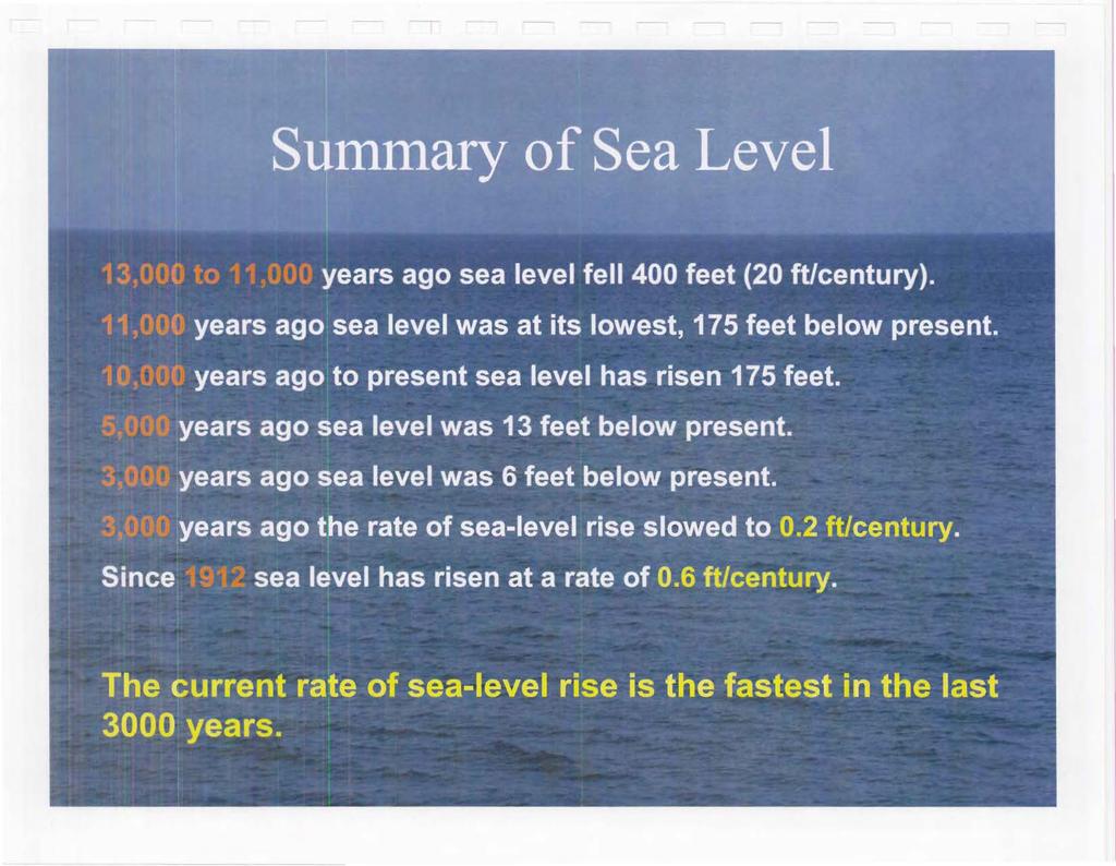
5 Glacial Retreat and Land Uplift 13,000 years ago: Continental glacier covered most of Maine, but was beginning to disappear from what is now the coast. Sea was in contact with icc margin. 12,000 years ago: Glacier had dis 1ppeared from central and southern ~aine. Uplift of land had caused ;ea to retreat. About 13,000 years ago a continental glacier melted and produced gravelly marine deltas and shelly marine mud offshore (left). Ice melt unloaded the earth and the land rose until about 12,000 years ago and resulted river deltas and beaches offshore (right). These offshore deposits are now over 100 feet below sea level. MGS graphic from Thompson and Borns ( 1985).

6 Pineo Ridge Delta, Columbia Aerial view of a sand and gravel delta in Washington County. The delta formed in the the ocean at a high stand of sea level as glaciers left Maine. MGS File Photo.
7 13,000 Years of Sea-Level ao-~~~~_.~~~~--~ _ Sea-Level Highstand Beaches Form \ -40 Sea-Level Lowstand -60~--~~~----~--~~~----~.-. I Time (ka B.P., C-14 years) The curve shows the fall and rise in the ocean over the last 13,000 years. In the last 3,000 years sea level has been relatively stable (a stillstand). From Dickson (1999) and based on Barnhardt (1994) and Belknap et al., (1987).
8 Ocean Shorelines in Maine Map showing the inland-most shoreline about 14,000 years ago, based on marine deltas and shelly marine sediment. The offshore shoreline position was about 11,000 years ago and defined by sediments in cores, radiocarbon age dates, and geophysical surveys of submerged strata. MGS/UMaine graphic based on Barnhardt (1994).
. In the last 3,000 years high tide has risen 6 feet (1.8 m) in southern Maine or 0.2 feet/century.")
9 5,000 Years of Sea-Level Rise Sea level over the last 5,000 years measured from submerged peat, tree stumps, and salt marsh deposits. The curve shows the rise in mean high water (MHW). In the last 3,000 years high tide has risen 6 feet (1.8 m) in southern Maine or 0.2 feet/century. Based on Gehrels (1994).
")
10 ... ~ Q)... Sea Level at Portland Q) E o.o - Mean Sea Level - Linear Regression 10 in. ruler -Q) > Q) J fa Q) U) -0.2 Slope 1.9 mm/yr, 0.61 ft/1 00 yr ~ t Time (year, )
11
 by the year 2100. 0.4 -...: - 0.2.. - 0.0~~~~====~ 1QQO 2000 2010 2020 2030 2040 2050 2060 2070 2080 20QO 2100 Year Source: IPCC Technical Summary of Working Group I Report, Fig.")
12 IPCC Sea Level Forecast - E -CD 'L: "" CD ii) ro CD CJ) 1.0 O.B A A 1T A1 Fl A Estimates range from 0.09 to 0.88 m 0.6 with a central value of 0.48 m (1.6 feet) by the year : ~~~~====~ 1QQO QO 2100 Year Source: IPCC Technical Summary of Working Group I Report, Fig. 24, p. 74.

13 Maine's Coastal Sand Dune System Coastal sand dunes are variable in size along the coast. The frontal dune is generally 125 to 150 feet in width (shore perpendicular) while back dune width varies. MGS has mapped about 2000 acres of large dune systems along about 30 miles of the Maine coast. About 1/3 of the dune acreage is frontal dune; 2/3 is back dunes. MGS File Photo of Seawall Beach by S. M. Dickson, 2002.
 Frontal dune ridge in Cape Elizabeth.")
14 Frontal Dune ~J~- ~~~ )~_A Processes ' ;.R ' )~/. ' 1 ' I \ , , M II\\ ~'----~... '/I- - \l.l.\\. l~ltd~ D hfll!r "t lon W.l\~ :tll3d,,\ccr(tjon 't... --:-.. - nonn:tl \\"JW ~tum Pntcllc: A US Army Corps of Engineers (1984) Frontal dune ridge in Cape Elizabeth. About half of the ridge was eroded and subsequently rebuilt with American beach grass and sand. MGS File Photo by S.M. Dickson, 1986.
. Dune scarps from major storms can take years to return to the pre-storm condition. MG")
15 Dune Scarp Formation December 1992 Northeaster, Seawall Beach, Phippsburg A 4-day northeaster in December 1992 resulted in a coastal storm surge (left) of less than 2 feet produced an erosional cut in the dunes. Northeasters commonly produce frontal dune erosion and scarp formation (right). Dune scarps from major storms can take years to return to the pre-storm condition. MGS File Photo by S. M. Dickson, 12/13/1992 (left) and 1/24/1992 (right)

16 Frontal Dune Overwash October 1991 "Perfect Storm," Saco Bay Beaches The fontal dune ridge is built primarily from wave action. In storms, waves deposit sand on the crest of the dune ridge. Most frontal dune ridges are built by the process of overwash to the elevation of active wave run-up and sand transport in a 1 00-year storm. Lesser storms add sand to low dune areas where wind and foot traffic have lowered the ground elevation. American beach grass grows through the new sand and helps hold it in place. MGS File Photos of Pine Point in Scarborough (left) and Ferry Beach State Park, Saco (right) by S. M. Dickson, 1991.
17 Back Dune, Saco The back dune environment has low-relief dunes with patchy vegetation and wind-blown sand. Some back dunes have a pitch pine forest. About one-third of the back dunes are in the 1 00-year floodplain. MGS File Photo by S. M. Dickson, 2002.
18 Sand Overwash Barrier Beach Sand Loss Migration with Rising - - PROFILE: Tl ME I PROFILE: TIME 2 SHOREFACE RAMP Sea Level J. T. Wells (1995, after Dubois, 1992). LAGOON BARRIER I SHOREFACE: Ocean Rise & Dune Retreat OL~R PRE'-HOLOCE NE SEOMENT9 NEW RAMP J. T. Wells (1995, after Everts, 1987).
.")
19 Signs of Dune Migration Drowned Forest, Kennebunk Drowned Salt Marsh, Wells Tree stumps (in situ) on a beach in Kennebunk were drowned by the rising sea (left). Salt marsh peat from the back barrier marsh is exposed on Laud holm Beach in Wells (right). In both locations, the barrier beach and dunes have migrated inland over forest and marsh environments due to sea-level rise of about 6 feet in the last 3,000 years. MGS File Photos by S. M. Dickson.
20 February 8, 1978 Storm ~~:~~ection Ullt /BOSton ~lobe!~o:~ J~.,..;~ :_:._,_. 13 h ~ a.,._,.. Co ~lull It II\[ 'Awesome' GO\. ~" HAEL.DtKAKIS, returning fron1 helicopter snney Peggotty Beach, Scituate. Globe photo by Dan Sheehan, v. 213, n. 40, 2/9/78.
 - Q) 2 :t: -g 0 0 - LL. -2 Tide Mean 1 2 3 4 5 6 7 8 9 10 11 12 13 14 Sea Level Storm Rank by Surge Amount")
21 Coastal Storm Flooding , ~~ ,.= Hurricane Carol ~ 10~~----~~--~ ~------~~ ~ Q) 1951 > a ca ; 6.!._ t: C) - Q) 2 :t: -g LL. -2 Tide Mean Sea Level Storm Rank by Surge Amount
22 Flood Zones and Waves Figure 3-1 Where wave runup elevations exceed wave crest elevations, the BFE is equal to the runup elevation. Wave Runup Depth ~ 3ft.I Inland Extent of Wave Run up til~ Wave Run up Depth< 3ft Wave runup elevation is the elevation reached by wave runup, referenced to the National Geodetic Vertical Datum of 1929 (NGVD) or other datum. Wave runup depth at any point is equal to the maximum wave runup elevation minus the lowest eroded ground elevation at that point. COASTAL CONSTRUCTION MANUAL iiii Source: FEMA Publication 55, p Coastal floodplains are dynamic and change with erosion and sea-level rise. A rise of 1 foot in southern Maine changes the 100-yr floodplain to a 10-yr floodplain. A rise of 6 inches in the sea makes the 100-yr flood a 500-yr flood.
23 ..-.. ~ Cl)... Sea Level at Portland Q) E o.o - Mean Sea Level _,_ Linear Regression in. ruler - Cl) > Cl) ca Q) en Slope 1.9 mm/yr, 0.61 ft/100 yr ~ o~ Time (year, )

24 Seawalls and Wave Reflection Seawalls result in wave reflection that causes enhanced beach scour in front of the wall. Over time the beach will lower and expose more of the wall. Continued erosion in front of the wall leads to a narrower beach and the need to reinforce or enlarge the wall to increase its resistance to wave action. MGS File Photos (Goose Rocks Beach, Kennebunk, 1990 (left) and Saco, 1986) by S. M. Dickson.
25 Seawall Damage Seawall Collapse and Rapid Beach Profile Adjustment Seawall failure results in rapid release of dune sand and fill from behind the wall. Foundations can be undermined before a storm ends and result in structural damage behind seawalls. MGS File Photos (Wells, 1987 and Saco, 1991) by S. M. Dickson.
26 North Jetty and Breakwater, Saco Coastal engineering at tidal inlets alter the natural movement of sand. In Saco, the jetty prevents Saco River sand from reaching the beach and wave reflection causes accelerated beach erosion and longshore drift. There are other federal jetties in Wells, Kennebunk, and Scarborough adjacent to beaches. MGS File Photo by S. M. Dickson, 2002.

27 Beach Nourishment and Sand Bags Sand pumped onto the beach and placed in bags on the beach Beach nourishment places additional sand on the beach profile to reduce the sand deficit. Sand bags were placed on the beach to attempt to slow the erosion rate in Saco. MGS File Photos by S.M. Dickson, 1992 left and J. T. Kelley, 1992, right.

28 Sand Movement Overwash sand replaced on the beach by Saco Public Works Storms repeatedly wash sand from the beach into the dune (road) at the intersection of North and Main Streets in Saco. The City of Saco regularly returns the sand to the beach. MGS File Photos by S. M. Dickson, 1990 left and P. A. Slovinsky, 2002, right.

29 Fortification of Seawalls Seawall reinforcement and expansion Sheet pile for reinforcement of seawalls along Beach Avenue in Kennebunk. Riprap in Saco slumps on the beach over the upper part of the beach profile. MGS File Photos by S. M. Dickson, 1999, left and 2002, right.

30 Old Orchard Beach Development located landward of a natural frontal dune ridge Ideal dune development is in the back dunes behind a wide frontal dune ridge. MGS File Photo by S.M. Dickson, 1986.
31 Laudholm Beach, Wells Development located landward of a natural frontal dune ridge Back dune development behind a wide frontal dune ridge and elevated on posts in Wells. MGS File Photo by S.M. Dickson, 1986.

32 Popham Beach Property Damage Erosion undermines homes at Hunnewell Beach, Phippsburg 1976 beach erosion at Hunnewell Beach, Phippsubrg J. T. Kelley, 1976 L. K. Fink, 1976

33 Popham Beach, Phippsburg Undermined and threatened by erosion, 2 homes retreat and elevate A damaged home at Hunnewell Beach in Phippsburg (left) and the neighboring home were moved landward and raised on posts after erosion in MGS File Photos by J. T. Kelley, left, 1983 and by S. M. Dickson, right, 1989.
34 Camp Ellis Property Loss Over 30 properties have been lost in less than 100 years. Historical lot map modified from Appendix E of the Sa co Bay Regional Beach Management Plan, Shorelines mapped in 1998 by the Saco Bay Beach Erosion Committee.
35 Camp Ellis, Saco Erosion undermines a home at Camp Ellis Beach prior to collapse Despite the threat of imminent collapse and a long-term erosion rate of 2 to 3 feet per year, this Saco property was enlarged prior to being destroyed in MGS File Photos by S. M. Dickson, left 1986 and right, 1990.

36 Camp Ellis Property Damage Erosion undermines homes at Camp Ellis Beach in Saco Surf and chronic erosion threaten the Camp Ellis neighborhood. The two homes in the left photo were destroyed by different storms. The house on the left was behind a seawall; the one on the right was not. MGS File Photos by S. M. Dickson, left 1986 and right 1990.
37 Beach Erosion and Recreation Continued beach erosion reduces the recreational beach width when dunes are fixed in place beneath frontal dune homes and do not migrate inland. Erosion in Wells (above) has limited the optimal time for recreation to about half of the tidal cycle. MGS File Photo by S.M. Dickson, 1990.
Geol 117 Lecture 18 Beaches & Coastlines. I. Types of Coastlines A. Definition:
 I. Types of Coastlines A. Definition: 1. Shore = narrow zone where ocean meets land (e.g. beach) 2. Coast is a broad area where both ocean and land processes act a. Includes onshore marshes, dunes, sea
The Coast: Beaches and Shoreline Processes
 1 2 3 4 5 6 7 8 9 The Coast: es and Shoreline Processes Trujillo & Thurman, Chapter 10 Oceanography 101 Chapter Objectives Recognize the various landforms characteristic of beaches and coastal regions.
The Coast: Beaches and Shoreline Processes Trujillo & Thurman, Chapter 10
 The Coast: es and Shoreline Processes Trujillo & Thurman, Chapter 10 Oceanography 101 Chapter Objectives Recognize the various landforms characteristic of beaches and coastal regions. Identify seasonal
Coastal Processes and Shoreline Erosion on the Oregon Coast, Cascade Head to Cape Kiwanda
 State of Oregon Department of Geology and Mineral Industries Vicki S. McConnell, State Geologist Open File Report OFR O-04-11 Coastal Processes and Shoreline Erosion on the Oregon Coast, Cascade Head to
Jasper Beach, Machiasport, Maine
 Maine Geologic Facts and Localities June, 2000 Jasper Beach, Machiasport, Maine 44 o 38 30.28 N, 67 o 22 31.96 W Text by Joesph T. Kelley, Department of Agriculture, Conservation & Forestry 1 Map by USGS
Adaptation to Sea Level Rise A Regional Approach
 Adaptation to Sea Level Rise A Regional Approach Project Partners: in Saco Bay, ME Peter Slovinsky, Marine Geologist Maine Geological Survey, Department of Conservation Project Funding from: Saco Bay Hazards
Coastal Processes 101 & The Regs. Greg Berman (Woods Hole Sea Grant & Cape Cod Cooperative Extension)
") Coastal Processes 101 & The Regs Greg Berman (Woods Hole Sea Grant & Cape Cod Cooperative Extension) March 26, 2019 Coastal Processes 101 & The Regs Outline: ~15 min talk Coastal Processes What is Erosion?
Coastal Processes 101 & The Regs Greg Berman (Woods Hole Sea Grant & Cape Cod Cooperative Extension) March 26, 2019 Coastal Processes 101 & The Regs Outline: ~15 min talk Coastal Processes What is Erosion?
Sea Level Rise and the Scarborough Marsh Scarborough Land Trust Annual Meeting April 24, 2018
 Sea Level Rise and the Scarborough Marsh Scarborough Land Trust Annual Meeting April 24, 2018 Peter A. Slovinsky, Marine Geologist Maine Geological Survey Funded by: 50% 40% Figure modified from Griggs,
Sea-level Rise on Cape Cod: How Vulnerable Are We? Rob Thieler U.S. Geological Survey Woods Hole, MA
 Sea-level Rise on Cape Cod: How Vulnerable Are We? Rob Thieler U.S. Geological Survey Woods Hole, MA Outline Sea-level and coastal processes Past sea-level change Predictions for the future Coastal responses
SEGMENTED BREAKWATERS AND THEIR USE IN COASTAL LOUISIANA
 SEGMENTED BREAKWATERS AND THEIR USE IN COASTAL LOUISIANA Prepared by: Louisiana Coastal Protection and Restoration Authority Engineering Division March 2016 The geology of Louisiana s coastal zone is intimately
Town of Old Orchard Beach: A summary of sea level rise science, storm surge, and some highlighted results from SLAWG work efforts
 Town of Old Orchard Beach: A summary of sea level rise science, storm surge, and some highlighted results from SLAWG work efforts October 15, 2013 Peter A. Slovinsky, Marine Geologist Maine Geological
Supplemental Slides. Shore: Junction of Land & Water. Junction of Land & Water. Sea Level Variations. Shore vs. Coast. Sea Level Variations
 Shore: Junction of Land & Water Supplemental Slides Sediments come off land Most get dumped at the beach Sediment interacts with ocean waves and currents Junction of Land & Water Features: Breaking waves,
Shore: Junction of Land & Water. Sediments come off land Most get dumped at the beach Sediment interacts with ocean waves and currents
 Shore: Junction of Land & Water Supplemental Slides Sediments come off land Most get dumped at the beach Sediment interacts with ocean waves and currents Junction of Land & Water Features: Breaking waves,
Coastal Processes 101. Greg Berman (Woods Hole Sea Grant & Cape Cod Cooperative Extension)
") Coastal Processes 101 Greg Berman (Woods Hole Sea Grant & Cape Cod Cooperative Extension) January 23, 2019 Coastal Processes 101 Outline: ~30 min talk Coastal Processes What is Erosion? Value of the Ecosystem
Coastal Processes 101 Greg Berman (Woods Hole Sea Grant & Cape Cod Cooperative Extension) January 23, 2019 Coastal Processes 101 Outline: ~30 min talk Coastal Processes What is Erosion? Value of the Ecosystem
Protecting the Storm Damage Prevention and Flood Control Interests of Coastal Resource Areas
 Protecting the Storm Damage Prevention and Flood Control Interests of Coastal Resource Areas Presented by: Massachusetts Department of Environmental Protection & Massachusetts Office of Coastal Zone Management
Weathering of Rocks. Weathering - Breakdown of rocks into pieces (sediment) 2 main types of weathering to rocks
 2 main types of weathering to rocks") Weathering of Rocks Weathering - Breakdown of rocks into pieces (sediment) 2 main types of weathering to rocks Mechanical weathering requires physical forces to break rocks into smaller pieces. Chemical
Weathering of Rocks Weathering - Breakdown of rocks into pieces (sediment) 2 main types of weathering to rocks Mechanical weathering requires physical forces to break rocks into smaller pieces. Chemical
Town of Cape Elizabeth: A summary of some of the latest sea level rise science and storm surge data to help guide municipal ordinance changes
 Town of Cape Elizabeth: A summary of some of the latest sea level rise science and storm surge data to help guide municipal ordinance changes May 29, 2014 Peter A. Slovinsky, Marine Geologist Maine Geological
SHORELINE AND BEACH PROCESSES: PART 2. Implications for Coastal Engineering
 SHORELINE AND BEACH PROCESSES: PART 2 Implications for Coastal Engineering Objectives of the lecture: Part 2 Show examples of coastal engineering Discuss the practical difficulties of ocean engineering
Active Coastal Processes in the Lubec Embayment
 The Lubec Embayment Maine Geologic Facts and Localities August, 1998 Active Coastal Processes in the Lubec Embayment 44 49 50.51 N, 66 59 34.16 W Text by Joseph T. Kelley, Department of Agriculture, Conservation
 Page 1 of 9 Name: Base your answer to the question on the diagram below. The arrows show the direction in which sediment is being transported along the shoreline. A barrier beach has formed, creating a
Connecticut Coastal Management Program
 Connecticut Coastal Management Program Fact Sheet for SHORELINE FLOOD AND EROSION CONTROL STRUCTURES What are Shoreline Flood and Erosion Control Structures? The Connecticut General Statutes (CGS) define
Map 4: Cowal Peninsula: Cluniter to Ardyne Point Map Content Descriptions
 Map 4: Cowal Peninsula: Cluniter to Ardyne Point Map Content Descriptions 1. Built Heritage and Archaeology A total of twenty four sites were recorded in the area covered by Map 4. Of these six were previously
The Marine Environment
 The Marine Environment SECTION 16.1 Shoreline Features In your textbook, read about erosional landforms, beaches, estuaries, longshore currents, and rip currents. For each statement below, write true or
In 1990, 50% of the U.S. population lived within 75 km of a coast. By 2010, 75% of the U.S. population will live within 75 km of a coast.
 In 1990, 50% of the U.S. population lived within 75 km of a coast. By 2010, 75% of the U.S. population will live within 75 km of a coast. High Tech Methods for Surveying the Deep Sea Floor Fig. 20.18 1
OVERWASHED SEDIMENT INTO THE GAMO LAGOON IN NANAKITA RIVER MOUTH AND EFFECTIVENESS OF THE OVERWASH PREVENTION CONSTRUCTION
 東北地域災害科学研究第 6 巻 (010) 191 OVERWASHED SEDIMENT INTO THE GAMO LAGOON IN NANAKITA RIVER MOUTH AND EFFECTIVENESS OF THE OVERWASH PREVENTION CONSTRUCTION ABSTRACT Xuan Tinh Nguyen 1, Ryutaro Hirao, Hitoshi
Phillip Island Nature Parks Coastal Process Study 8 October 2014
 Phillip Island Nature Parks Coastal Process Study 8 October 2014 Project Overview Coastal Geology Basaltic and fragmented lavas, granite at Pyramid Rock and Cape Woolamai Weathered basalt (>10m thick)
Maine Coastal Property Owner s Guide to Erosion, Flooding, and Other Hazards
 Maine Coastal Property Owner s Guide to Erosion, Flooding, and Other Hazards Peter A. Slovinsky, Marine Geologist, Maine Geological Survey Purpose of this Guide The Maine Geological Survey created this
Section 145 Climate Change and Sea Level Rise
 Section 145 Climate Change and Sea Level Rise A. Definitions Rhode Island Coastal Resources Management Program 1. Climate is the long-term weather average observed within a geographic region, and climate
COASTAL DYNAMICS VIRTUAL FIELD TRIP, NORTHEAST FLORIDA. Joann Mossa Department of Geography University of Florida
 COASTAL DYNAMICS VIRTUAL FIELD TRIP, NORTHEAST FLORIDA Joann Mossa Department of Geography University of Florida WHERE ARE WE GOING? In NE Florida (Flagler and St. Johns County, south of St. Augustine),
Lab 12 Coastal Geology
 Lab 12 Coastal Geology I. Fluvial Systems Hydrologic Cycle Runoff that flows into rivers = precipitation (rain and snowmelt) [infiltration (loss to groundwater) + evaporation (loss to atmosphere) + transpiration
SECTION 13: SEA LEVEL RISE ADAPTATION
 Appropriate quote here. SECTION 13: SEA LEVEL RISE ADAPTATION 1. Statement of State and Local Goals. A. State Goals: There are currently no State goals related to sea level rise. B. Local Goals: 1. TBD
MEMORANDUM FOR SWG
 MEMORANDUM FOR SWG-2007-1623 Subject: Jurisdictional Determination (JD) for SWG-2007-1623 on Interdunal Wetlands Adjacent to Traditional Navigable Waters (TNWs) Summary The U.S. Environmental Protection
Coastal Sediment Transport
 Coastal & Marine Coastal Sediment Transport Mazen Abualtayef Assistant Prof., IUG, Palestine Sediment Transport Sediment is any particulate matter that can be transported by fluid flow and which eventually
Latest trends in sea level rise and storm surges in Maine Peter A. Slovinsky, Marine Geologist
 Latest trends in sea level rise and storm surges in Maine Peter A. Slovinsky, Marine Geologist Image from Chebeague.org Maine s glacial geology and historic sea level rise trends Current sea level trends
The Marine Environment
 The Marine Environment SECTION 16.1 Shoreline Features In your textbook, read about erosional landforms, beaches, estuaries, longshore currents, and rip currents. For each statement below, write or. 1.
The Geology of Sebago Lake State Park
 Maine Geologic Facts and Localities September, 2002 43 55 17.46 N, 70 34 13.07 W Text by Robert Johnston, Department of Agriculture, Conservation & Forestry 1 Map by Robert Johnston Introduction Sebago
Shoreline and Climate Change Adaptation Alternatives for The Letter Parcel, Bolinas Lagoon
 Shoreline and Climate Change Adaptation Alternatives for The Letter Parcel, Bolinas Lagoon Scenic shoreline vista of Bolinas Lagoon and ridges, from Letter Parcel, March 2016 Peter Baye, Coastal Ecologist
Glacial Geology of Moose Point State Park, ME
 Geologic Site of the Month May, 2013 Glacial Geology of Moose Point State Park, Maine 44 o 25 59.18"N, 68 o 56 37.11"W Text and photos by Woodrow B. Thompson, Department of Agriculture, Conservation &
Tony Pratt, DNREC to The Center for the Inland Bays Scientific and Technical Advisory Committee. August 21, 2009
 Sea Level Rise in Delaware Presented by Tony Pratt, DNREC to The Center for the Inland Bays Scientific and Technical Advisory Committee August 21, 2009 Sea level has been fluctuating ever since there have
Coasts Key Word Glossary
 Coasts Key Word Glossary Abrasion Also known as corrosion. It is the wearing away of the cliff by sand, fragments of rock and boulders that are being hurled at the cliff by the waves. It causes grinding
Turn and Face the Strange: Economic Impacts of Climate Change Sea Level Rise and Coastal Flooding E2Tech Forum June 21, 2018
 Turn and Face the Strange: Economic Impacts of Climate Change Sea Level Rise and Coastal Flooding E2Tech Forum June 21, 2018 Peter A. Slovinsky, Marine Geologist Maine Geological Survey Image from Chebeague.org
5. MANY COASTAL COMMUNITIES AND FACILITIES WILL FACE INCREASING EXPOSURE TO STORMS.
 5. MANY COASTAL COMMUNITIES AND FACILITIES WILL FACE INCREASING EXPOSURE TO STORMS. Climate change is altering the Arctic coastline and much greater changes are projected for the future as a result of
DIVISION OF COASTAL MANAGEMENT TO STUDY CURRENT LONG-TERM EROSION RATES ADJACENT TO TERMINAL GROINS
 DIVISION OF COASTAL MANAGEMENT TO STUDY CURRENT LONG-TERM EROSION RATES ADJACENT TO TERMINAL GROINS North Carolina Department of Environmental Quality Division of Coastal Management February 22, 2018 N.
Major Hurricane Earl
 Major Hurricane Earl Advisory 33 North Carolina Threat Assessment Prepared at: 11 AM Thursday September 2, 2010 Hurricane and Tropical Storm Warnings in effect for the North Carolina Coast and Sounds NWS
Controlling Processes That Change Land
 1 Name Date Controlling Processes That Change Land People try to control some of the processes that change land. To do this, people apply technology- the use of science to solve problems in everyday life.
Map 10: Ayrshire Coast: Barassie to Prestwick North Map Content Descriptions
 Map 10: Ayrshire Coast: Barassie to Prestwick North Map Content Descriptions 1. Built Heritage and Archaeology A total of thirteen sites were recorded in the area covered by Map 10. Of these nine were
Erosion and Deposition
 CHAPTER 3 LESSON 2 Erosion and Deposition Landforms Shaped by Water and Wind Key Concepts What are the stages of stream development? How do water erosion and deposition change Earth s surface? How do wind
Weathering, Erosion, and Deposition
 Weathering, Erosion, and Deposition E Q : H O W I S T H E E A R T H A F F E C T E D B Y C O N S T R U C T I V E A N D D E S T R U C T I V E F O R C E S? http://player.discoveryeducation.com/index.cfm?guidassetid=6b1e329e-5a77-4b36-bfa9-1d307f75441c&blnfromsearch=1&productcode=us
Changes to Land 5.7B. landforms: features on the surface of Earth such as mountains, hills, dunes, oceans and rivers
 All the landforms on Earth have changed over time and continue to change. Many of the changes were caused by wind, moving water, and moving ice. Mountains have grown and shrunk. Rivers have cut away land
Science EOG Review: Landforms
 Mathematician Science EOG Review: Landforms Vocabulary Definition Term canyon deep, large, V- shaped valley formed by a river over millions of years of erosion; sometimes called gorges (example: Linville
Think about the landforms where you live. How do you think they have changed over time? How do you think they will change in the future?
 reflect All the landforms on Earth have changed over time and continue to change. Many of the changes were caused by wind, moving water, and moving ice. Mountains have grown and shrunk. Rivers have cut
Section 2.1 Ocean Basins. - Has helped determine where ocean basins are located. - Tectonic plates move changing the position of the continents.
 Science 8 Unit 1: Water Systems on Earth Chapter 2: Oceans Control the Water Cycle Section 2.1 Ocean Basins Oceans are important because: 1. Primary water source for the water cycle 2. Control weather
Moosehead Lake and the Tale of Two Rivers
 Maine Geologic Facts and Localities June, 2005 45 o 53 5.09 N, 69 o 42 14.54 W Text by Kelley, A.R.; Kelley, J.T.; Belknap, D.F.; and Gontz, A.M. Department of Earth Sciences, University of Maine, Orono,
Map 2: Cowal Peninsula: Lazaretto Point to Dunoon Harbour North Map Content Descriptions
 Map 2: Cowal Peninsula: Lazaretto Point to Dunoon Harbour North Map Content Descriptions 1. Built Heritage and Archaeology A total of thirteen sites were recorded in the area covered by Map 2. Of these
core mantle crust the center of the Earth the middle layer of the Earth made up of molten (melted) rock
 rock") core the center of the Earth mantle the middle layer of the Earth made up of molten (melted) rock crust the surface layer of the Earth that includes the continents and oceans 1 continental drift the theory
core the center of the Earth mantle the middle layer of the Earth made up of molten (melted) rock crust the surface layer of the Earth that includes the continents and oceans 1 continental drift the theory
4.2 Tidal Wetlands. Phragmites Australis
 4.2 Tidal Wetlands Few topics elicit such strong emotions in Guilford as the current state of salt marshes. These marshes, more broadly known as tidal wetlands, are undergoing a transformation as sea level
Storm Induced Coastal Erosion for Flood Insurance Studies and Forecasting Coastal Flood Damage Impacts: Erosion, Runup & Overtopping
 Storm Induced Coastal Erosion for Flood Insurance Studies and Forecasting Coastal Flood Damage Impacts: Erosion, Runup & Overtopping Jeff Gangai- Dewberry Tucker Mahoney FEMA HQ Introduction Background
Should I Sell My Shore House? NJ As a Natural Laboratory for Sea-level Change Ken Miller, Chair of Geological Sciences (FAS)
") Should I Sell My Shore House? NJ As a Natural Laboratory for Sea-level Change Ken Miller, Chair of Geological Sciences (FAS) Hurricane Isabelle, Avalon, NJ 9/18/2003 December Nor easter, LBI, 12/1993 Ash
Should I Sell My Shore House? NJ As a Natural Laboratory for Sea-level Change Ken Miller, Chair of Geological Sciences (FAS) Hurricane Isabelle, Avalon, NJ 9/18/2003 December Nor easter, LBI, 12/1993 Ash
Coastal issues: Beaches and Estuaries
 Coastal issues: Beaches and Estuaries Definitions: Coast = broad zone where both marine & terrestrial processes act It includes the beach, lagoons, marshes, bars etc. Coastal processes act to shape the
Map 9: Ayrshire Coast: Stevenston Pier to Barassie Map Content Descriptions
 Map 9: Ayrshire Coast: Stevenston Pier to Barassie Map Content Descriptions 1. Built Heritage and Archaeology A total of thirteen sites were recorded in the area covered by Map 9. Of these five were previously
ACCELERATED BEACH EROSION ALONG THE UPPER TEXAS COAST
 ACCELERATED BEACH EROSION ALONG THE UPPER TEXAS COAST Young Hyun Park 1, Billy L. Edge 2 and Sehyun Cheon 3 The upper Texas coast has been severely eroded and beach erosion is going on. It is not extreme
ENGINEERING APPROACHES TO SHORELINE PLACEMENT FROM COAST TO COAST
 ENGINEERING APPROACHES TO SHORELINE PLACEMENT FROM COAST TO COAST 237 237 237 217 217 217 200 200 200 0 0 0 163 163 163 131 132 122 80 119 27 252 174.59 83 36 118 110 135 120 112 92 56 62 102 130 Comparing
Rising Sea Simulation in Buzzards Bay! Via the Augmented Reality Sandbox
 Rising Sea Simulation in Buzzards Bay! Via the Augmented Reality Sandbox Teacher Copy Concepts: Contour Maps Buzzards Bay Estuary Sea Level change Hurricanes Storm surge/coastal Flooding Human development
TECHNIQUES FOR ASSESSING COASTAL HAZARD AREAS FOR THE GISBORNE DISTRICT COAST
 TECHNIQUES FOR ASSESSING COASTAL HAZARD AREAS FOR THE GISBORNE DISTRICT COAST July 1994 C.R. 1994/12 Jeremy G Gibb 2009 All rights reserved. This work is entitled to the full protection given by the Copyright
How does erosion happen?
 How does erosion happen? By National Geographic, adapted by Newsela staff on 10.03.17 Word Count 682 Level 830L These rock formations, in Bryce Canyon National Park, Utah, are called hoodoos. Although
Application #: TEXT
 TOWN OF FORT MYERS BEACH 2008 PROPOSED COMPREHENSIVE PLAN AMENDMENTS Application #: 2008-13-TEXT Description: Modify the Coastal Management and Future Land Use Elements to reflect the state s new definition
Environment Bay of Plenty Ohope Beach system
 Environment Bay of Plenty 7 5. Ohope Beach system Environmental Publication 27/ NERMN Beach Profile Monitoring Environment Bay of Plenty 5..1 Ohope Spit (CCS 9) Discussion The site is located 2m to the
The Erosion Problem: Perspectives. Physical
 Greg Berman The Erosion Problem: Perspectives Physical Education Regulation The Erosion Problem: Physical Perspectives What is a hotspot? Erosion Rate / Vulnerability / Frame of Reference Sandwich Town
A Perfect Storm: The Collision of Tropical Cyclones, Climate Change and Coastal Population Growth. Jeff Donnelly Woods Hole Oceanographic Institution
 A Perfect Storm: The Collision of Tropical Cyclones, Climate Change and Coastal Population Growth Jeff Donnelly Woods Hole Oceanographic Institution Recent Hurricane Trends What Might the Future Hold?
Erosion Information Paper - Barrow, Alaska Current as of September 14, 2007
 U.S. Army Corps of Engineers ALASKA BASELINE EROSION ASSESSMENT Erosion Information Paper - Barrow, Alaska Current as of September 14, 2007 Community Information Barrow (BARE-row, a.k.a. Ukpeagvik), population
2nd Grade. Wind, Water and Land.
 1 2nd Grade Wind, Water and Land 2015 11 23 www.njctl.org 2 Wind, Water and Land What is Wind? Wind Erosion Preventing Wind Erosion Water Erosion Sudden Water Erosion Preventing Water Erosion Landforms
Developed in Consultation with Florida Educators
 Developed in Consultation with Florida Educators Table of Contents Next Generation Sunshine State Standards Correlation Chart... 7 Benchmarks Chapter 1 The Practice of Science...................... 11
LOMR SUBMITTAL LOWER NESTUCCA RIVER TILLAMOOK COUNTY, OREGON
 LOMR SUBMITTAL LOWER NESTUCCA RIVER TILLAMOOK COUNTY, OREGON Prepared for: TILLAMOOK COUNTY DEPARTMENT OF COMMUNITY DEVELOPMENT 1510-B THIRD STREET TILLAMOOK, OR 97141 Prepared by: 10300 SW GREENBURG ROAD,
Mapping of Future Coastal Hazards. for Southern California. January 7th, David Revell, Ph.D. E.
 Mapping of Future Coastal Hazards for Southern California January 7th, 2014 David Revell, Ph.D. drevell@esassoc.com E. Vandebroek, 2012 Outline Coastal erosion hazard zones Flood hazard zones: Coastal
Regional-scale understanding of the geologic character and sand resources of the Atlantic inner continental shelf, Maine to Virginia
 Regional-scale understanding of the geologic character and sand resources of the Atlantic inner continental shelf, Maine to Virginia Workshop on Dredging, Beach Nourishment and Bird Conservation Atlantic
What are the different ways rocks can be weathered?
 Romano - 223 What are the different ways rocks can be weathered? Weathering - the breakdown of rocks and minerals at the Earth s surface 1. 2. PHYSICAL WEATHERING Rock is broken into smaller pieces with
Hurricane Matthew. Life Threatening Flash Flooding Likely. National Weather Service Wilmington NC. Josh Weiss, Meteorologist
 Hurricane Matthew Life Threatening Flash Flooding Likely Threat Assessment for northeast South Carolina & southeast North Carolina National Weather Service Wilmington NC 630 PM EDT Friday October 7, 2016
Primer on Coastal Erosion And Habitat Creation
 2 nd Regional Conference Dredging, Beach Nourishment & Bird Conservation Primer on Coastal Erosion And Habitat Creation Timothy Kana Ph.D Source: Newsday 1962 Photo by Kelsey Aerials 1978 Source: U Mass
Chapter 3 Erosion and Deposition. The Big Question:
 Chapter 3 Erosion and Deposition The Big Question: 1 Design a way to represent and describe the 4 types of mass movement. You may use pictures, diagrams, list, web, chart, etc 2 Chapter 3: Erosion and
Importance of Understanding Coastal Landforms
 Importance of Understanding Coastal Landforms Costa Concordia Shipwreck, Isola del Giglio, Italy Depositional Coastal Landforms Can interpret landforms in light of geomorphic processes, both terrestrial
EROSION HAZARD OF MINNESOTA'S LAKE SUPERIOR SHORELINE. Carol A. Johnston Principal Investigator
 EROSION HAZARD OF MINNESOTA'S LAKE SUPERIOR SHORELINE Carol A. Johnston Principal Investigator Maps prepared by: James Salés, John Bonde, Tim Aunan, and Richard Raby Minnesota Sea Grant Research Bulletin
Impact of Sea Level Rise on Future Storm-induced Coastal Inundation
 Impact of Sea Level Rise on Future Storm-induced Coastal Inundation Changsheng Chen School for Marine Science and Technology, University of Massachusetts-Dartmouth Email: c1chen@umassd.edu 04/14/2015 Outline
Hurricanes and Storm Surge : Before coming to lab, visit the following web site:
 Geol 108 Lab #7 Week of October 15-19, 2012 Coastal Studies Hurricanes and Storm Surge : Before coming to lab, visit the following web site: http://www.usatoday.com/graphics/weather/gra/gsurge/flash.htm
Understanding coastal erosion in Alaska
 Understanding coastal erosion in Alaska Alaska Center for Climate Assessment and Policy Statewide Teleconference October 9, 2007. David E. Atkinson International Arctic Research Center / Atmospheric Science
Coastal Flood Risk Study Project for East Coast Central Florida Study Area
 Coastal Flood Risk Study Project for East Coast Central Florida Study Area St Lucie County, Florida Flood Risk Review Meeting March 28, 2017 Introductions Risk MAP Project Team FEMA Region IV BakerAECOM,
2.2.7 Backbarrier flats
 FIGURE 24. VERTICAL PHOTOGRAPH SHOWING THE DEVELOPMENT OF SMALL PARABOLIC DUNES FROM BLOWOUTS IN A LARGE RELICT FOREDUNE NORTHWEST OF HUNTER'S CREEK. PHOTOGRAPH COURTESY OF CAR'T'ER HOLT HARVEY FORESTS
ON THE EVOLUTION OF A HOLOCENE BARRIER COAST
 ON THE EVOLUTION OF A HOLOCENE BARRIER COAST Response to sea-level change and sediment supply DANCORE Seminar 2014 COADAPT - Danish Coasts and Climate Adaptation Flooding Risk and Coastal Protection Mikkel
Name Roy G Biv Page 1
 Name Roy G Biv Base your answers to questions 1 through 3 on the diagram below. The arrows show the direction in which sediment is being transported along the shoreline. A barrier beach has formed, creating
The History of Sea Level Rise in Delaware Bay: SLR has Little Impact on the Morphology of Limulus or its Functional Spawning Habitat
 The History of Sea Level Rise in Delaware Bay: SLR has Little Impact on the Morphology of Limulus or its Functional Spawning Habitat Bob Loveland (Rutgers Univ.) & Mark Botton (Fordham Univ.) There are
Australian Coastal Councils Conference
 Australian Coastal Councils Conference 11 March 2015 Estimating Future Coastal Inundation and Erosion Hazards Dr Andrew McCowan Dr Christine Lauchlan-Arrowsmith Warwick Bishop Background Victorian Future
Changes in Texas Ecoregions Copy the questions and answers
 Changes in Texas Ecoregions Copy the questions and answers 1. What are some kinds of damage that hurricanes cause? Roads and bridges might be washed away. Trees and power lines can be knocked down. Area
GenCade. Combining and Extending the GENESIS and Cascade Models for Planning and Design in a Regional Sediment Management Framework
 GenCade Combining and Extending the GENESIS and Cascade Models for Planning and Design in a Regional Sediment Management Framework G Presented by Nicholas C. Kraus For the GenCade Development Team Ken
Professors Dean and Dalrymple are also authors of the well-known Water Wave Mechanics for Engineers and Scientists.
 COASTAL PROCESSES The world s coastlines, dividing land from sea, are geological environments unique in their composition and the physical processes affecting them. Humans have been building structures
Landslide & Coastal Erosion Risk Reduction at Oregon s Water/Wastewater Networks
 Landslide & Coastal Erosion Risk Reduction at Oregon s Water/Wastewater Networks Laura Gabel, RG (with Bill Burns, RG & Jonathan Allan, Ph. D) Oregon Department of Geology and Mineral Industries (541)
COASTAL GEOLOGIC HAZARDS AND SEA-LEVEL RISE: CLIMATE CHANGE IN RHODE ISLAND
 COASTAL GEOLOGIC HAZARDS AND SEA-LEVEL RISE: CLIMATE CHANGE IN RHODE ISLAND Sakonnet Preservation Association Annual Meeting 9 July 2013 Jon C. Boothroyd 1,2 and Bryan A. Oakley 3 (1) Rhode Island Geological
Earth processes are dynamic actions that occur both on
 29 Weathering, Erosion, and Deposition R EA D I N G Earth processes are dynamic actions that occur both on the earth s surface and inside the earth. Any process that breaks down earth material, such as
CLIMATE READY BOSTON. Climate Projections Consensus ADAPTED FROM THE BOSTON RESEARCH ADVISORY GROUP REPORT MAY 2016
 CLIMATE READY BOSTON Sasaki Steering Committee Meeting, March 28 nd, 2016 Climate Projections Consensus ADAPTED FROM THE BOSTON RESEARCH ADVISORY GROUP REPORT MAY 2016 WHAT S IN STORE FOR BOSTON S CLIMATE?
Hurricane Matthew Life Threatening Flash Flooding Likely
 Hurricane Matthew Life Threatening Flash Flooding Likely Threat Assessment for northeast South Carolina & southeast North Carolina National Weather Service Wilmington NC 12 AM EDT Saturday October 8, 2016
Weathering, Erosion, and Deposition Guided Notes
 1. Weathering, Erosion, and Deposition 2. Outline Section 1: Weathering Section 2: Erosion Section 3: Deposition Section 4: Case Study Weathering, Erosion, and Deposition Guided Notes 3. Section 1: Weathering
Summary Visualizations for Coastal Spatial Temporal Dynamics
 Summary Visualizations for Coastal Spatial Temporal Dynamics October 24 2011 Providence, RI Sidharth Thakur 1, Laura Tateosian 2, Helena Mitasova, Eric Hardin, and Margery Overton 1. sthakur@renci.org,