COASTAL GEOLOGIC HAZARDS AND SEA-LEVEL RISE: CLIMATE CHANGE IN RHODE ISLAND
|
|
|
- Mercy Hunter
- 6 years ago
- Views:
Transcription


")
1 COASTAL GEOLOGIC HAZARDS AND SEA-LEVEL RISE: CLIMATE CHANGE IN RHODE ISLAND Sakonnet Preservation Association Annual Meeting 9 July 2013 Jon C. Boothroyd 1,2 and Bryan A. Oakley 3 (1) Rhode Island Geological Survey (2) Department of Geosciences, University of Rhode Island, Kingston RI (3) Environmental Earth Science Department, Eastern Connecticut State University, Willimantic, CT 06226
2 Summary for Rhode Island: Glacial Geology, Past and Present, the Underlying Key to Understanding Processes and Products Storms the Most Important Driver in Coastal Change Sea-Level Rise a Secondary Effect Shoreface Sediment Transport Not Well Understood at Present Future Major Storms Combined With Sea-Level Rise a Very Large Problem Accelerated Sea-Level Rise Resulting in Inundation also a Very Large Potential Problem RICRMC Planning for a 3-5 foot Rise by 2100 and a 1.0 to 1.5 foot Rise by 2050

3 You are here


4 GEOLOGIC SHORE ZONE TYPES Percent Beach Plain and Barrier Spit 25 Glacial Stratified Bluff 8 Till Bluff 23 Metamorphosed Sedimentary Bedrock 8 Igneous and Other Meta Bedrock 5 Discontinuous Bedrock 1 Shoreline Protection Structure 30

5 Glacial Till Deposits gravel, sand, silt

6 Till Bluff - Church Point, Little Compton Hehre FEB 2007, 14:00

7 Discontinuous Bedrock - Church Point, Little Compton Hehre 2007

8 Sakonnet Golf Club Area Shoreline Change Oakley, Hehre and Boothroyd 2013


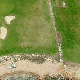
9 Sakonnet Golf Club Area Revetment Discontinuous Bedrock Bing Maps 2008

10 S New England, E New York, Continental Shelf at LGM ~ 26,000 ybp RI You are here Map Generated By: BA Oakley and JC Boothroyd

11 Glacial Lakes Block Island and Rhode Island ~ 21,300 ybp You are here Charlestown Moraine Ice margins modified from: Dyke and Prest, 1987 Ridge, 2010; Goss, 1993 Smith, 2010 Oakley, 2012

12 QUATERNARY DEPOSITS OF RHODE ISLAND Granitic Till Upland Thick Stratified Deposits Narragansett structural basin Compact Till Upland EXPLANATION Stratif ied Material Till End Moraine - Till and Stratif ied Material You are here Miles Block Island Complex Kilometers
13 Eustatic Sea-Level Rise + Isostatic Rebound at Block Island RI Isostatic Rebound Relative Sea Level Laurentide Ice Laurentide Sheet? 2m Ice. 100yr Sheet? -1 2m. 100yr -1 Eustatic Sea Level Antarctic Ice Sheet? 2-5m. 100yr -1 Explanation Oakley and Boothroyd, July 2012

14 Narragansett Pier, RI Seawall Tropical Storm Irene 2011 Storms are the Driver Anonymous via N Vinhateiro, 28 aug 2011

15 Narragansett Pier Superstorm Sandy J Peabody via Facebook

16 Sediment Transport Pathways Charlestown Green Hill Barrier and Headland The Message: Many Directions and Processes Ninigret Lagoon Green Hill Lagoon Green Hill Headland Trustom Lagoon

17 Superstorm Sandy Charlestown Beach M Dowling S McCandless 30 Oct 2012

18 Superstorm Sandy Charlestown Beach Washover Fan Deposition M Dowling S McCandless 30 Oct 2012
19 Sandy Geologic Summary: Sandy a Tropical Extratropical Hybrid Significant Wave Height 31 feet at Inner Shelf Buoy; Max Recorded Wave Height 47 feet RI Received a Glancing Blow ; But Public Misconception by Some Believe it a 100 Year Event Greatest Geologic Change and Infrastructure Damage Since Hurricane Carol, 1954 Washover Fan Deposition an Underestimated Problem Shoreline Change Special Area Management Plan Needed to Better Prepare for Next Event Already Underway


20 Buoy SE of Block Island Significant wave height = 31ft Max wave height 47 ft
21 Superstorm Sandy Tropical-Extratropical Hybrid 29 October 2012 Newport Tide Gauge SET UP PREDICTED STORM SURGE data_menu.shtml?stn= %20newport,%20ri&type=tide+data
22 How High was the Water? Water Levels Newport, RI Maximum Water Level 9.46 Feet, 2.88 meters Above MHHW Carol Water Level Sandy Water Level 4.25 Feet, 1.30 meters Above MHHW Boothroyd and Hehre 2008 Why above MHHW? MHHW = 3.85 ft, m MLLW = 0.0 ft, 0.0 m Adapted from: s-cgibin/ngs_opsd.prl?pid=lw 0493&EPOCH=
23 Frequency? Next Month or Next Year Tropical Storm Irene Aug 2011 Superstorm Sandy Oct 2012 Hurricane Bob Aug 1991 Adapted from NOAA; USACE 1988; Hehre 2007

24 Charlestown Beach Superstorm Sandy Cha-Ez Profile RI DOT 30 Oct 2012


25 Measuring Shore Transects with: 2 Sticks and A String or, the Modified Emery Method -22cm Eric Woodward 12 Oct 2012

26 1938 Storm Surge + Waves 1938 Storm Surge Barrier Core 1978 Backshore Reservoir Active Berm MHHW / MHW


27 Beach Cycles RI Shore Boothroyd and Galagan, 1999

28 Cha-Ez Profile - Charlestown Barrier - Post Sandy Washover Fan Deposition S McCandless 30 Oct 2012
29 Post Sandy Pre-Sandy FEMA Dune Erosion Protocol

30 Charlestown Beach Blizzard 1978 No Berm JC Boothroyd
31 Barrier - Beach and Foredune Zone - 35 Year Reset Post Sandy Blizzard 1978


32 Elevation Difference USACE Post Sandy and 2011 USGS LiDAR DEMs Washover Fan Deposition Charlestown Barrier Foredune Removal Cha-Ez Profile DRAFT FIGURE PRELIMINARY RESULTS

33 Pre-Sandy Quonochontaug Barrier Conservation Land Washover Fan Deposition Bousquet and Son Aerial Views

34 Post-Sandy Quonochontaug Barrier Conservation Land Washover Fan Deposition Bousquet and Son Aerial Views

35 Charlestown Beach, RI Storm Surge Overwash With Washover Fan JC Boothroyd Feb 1985

36 Superstorm Sandy Charlestown Beach Washover Fan Deposition S McCandless M Dowling 30 Oct 2012

37 Elevation Difference USACE Post Sandy and 2011 USGS LiDAR DEMs Charlestown Barrier Washover Fan Deposition Cha-Ez Profile Foredune Removal DRAFT FIGURE PRELIMINARY RESULTS

38 Washover Fan Deposition - Charlestown Beach Cha-Ez Profile 31 Oct

39 Washover Fan Removal Charlestown Beach M Dowling S McCandless 30 Oct 2012

40 Charlestown Beach, RI Hurricane Bob 1991 Washover Fan Deposition Removal is a Bad Idea. Barriers Naturally Retreat Landward and Upward Aug 1991 JC Boothroyd

41 A General Coastal Barrier Model for Rhode Island Very Transgressive

42 Napatree Barrier Westerly, RI Little Narragansett Bay Watch Hill Hehre and Boothroyd, 2007
43 Napatree Barrier Shoreline Change Map 1939 Sound Side 2004 Sound Side -71.6m 1939 Ocean Side 2004 Ocean Side Hehre and Boothroyd, 2007
44 Napatree Barrier Shoreline Change Map 1939 Sound Side 2004 Sound Side -71.6m 1939 Ocean Side 2004 Ocean Side Hehre and Boothroyd, 2007

45 Napatree Barrier Shoreline Change Map 1939 Sound Side 2004 Sound Side -71.6m 1939 Ocean Side 2004 Ocean Side Hehre and Boothroyd, 2007

46 South Kingstown, RI Town Beach An Eroding Glacial Bluff Shore BA Oakley

47 South Kingstown, RI Town Beach An Eroding Glacial Bluff Shore Boardwalk Pilings RI DOT 30 Oct 2012


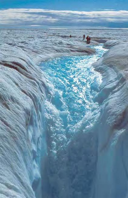
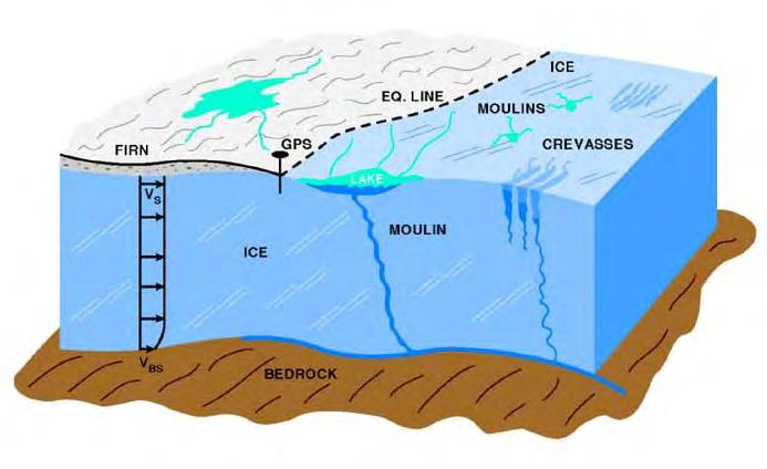
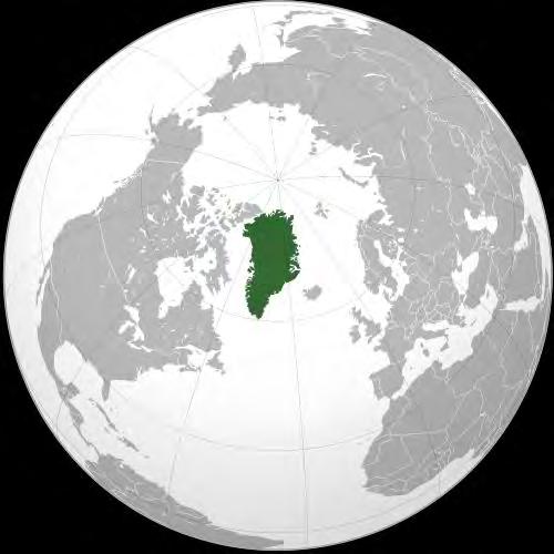
48 Headland Erosion Glacial Stratified Bluff 28m Rasmussen, Oakley and Boothroyd 2013


49 Briggs Marsh Lagoon and Briggs Barrier Hehre and Boothroyd 2007

50 Briggs Barrier: Shoreline Change Oakley, Hehre and Boothroyd 2013
51 A Brief Look at Climate Change and the Future Shore Zone of Rhode Island

52 Carbon Dioxide - CO 2 Levels A Cause for Concern Now 399+ ppm
53 Co2now.org


54 HEIGHT NOW Adapted from: sltrends_station.shtml?stnid= %20newport,%20ri Boothroyd 2013

55 6.0 ft VR Max 184 cm 4.5 ft VR A1F1 136 cm VR B1 99 cm 1.3 ft Height above NOW
56 Greenland Outlet Glaciers Change from Polythermal to Warm Based means that the calving front is unstable A Key to Future Sea-Level Rise

57 Brathwaite, 2002

58 Ninigret Green Hill Lagoons Orthophoto Today

59 Ninigret Green Hill Lagoons 2100 Inundation 5 ft 200 ft Barrier Migration Projected

60 Matunuck Shoreline Change South Kingstown Town Beach Based on Net shoreline movement Oakley and Boothroyd 2013

61 Matunuck Shoreline Change South Kingstown Town Beach Based on Net shoreline movement Oakley and Boothroyd 2013

62 Matunuck Headland South Kingstown 1938 Hurricane + 5 ft Sea Level Rise Roy Carpenter s Beach Matunuck Beach Road Oakley and Boothroyd 2013

63 Matunuck Headland South Kingstown 1938 Hurricane + 5 ft Sea Level Rise + Erosion Roy Carpenter s Beach Matunuck Beach Road Oakley and Boothroyd 2013

64 Briggs Marsh Lagoon Projected Inundation 1938 Hurricane + 5 ft Sea Level Rise 14.5 feet above MHHW Oakley and Boothroyd 2013

65 Sakonnet Point Projected Inundation 1938 Hurricane + 5 ft Sea Level Rise 14.5 feet above MHHW Oakley and Boothroyd 2013

66 Wickford Marketplace In-Place Inundation The Bathtub Ring Today 28 Oct 2011 MelissaDevine9
67 End of Presentation
UNDERSTANDING COASTAL GEOLOGIC HAZARDS, SEA LEVEL RISE and CLIMATE CHANGE in THE NORTHEASTERN US
 UNDERSTANDING COASTAL GEOLOGIC HAZARDS, SEA LEVEL RISE and CLIMATE CHANGE in THE NORTHEASTERN US Congressional Hazards Caucus Briefing Washington, DC 18 November 2009 Jon C. Boothroyd Rhode Island Geological
CHAPTER 4 Rhode Island s Exposure to Coastal Hazards
 CHAPTER 4 Rhode Island s Exposure to Coastal Hazards Table of Contents List of Figures... 3 List of Tables... 5 4.1 Chapter Highlights... 7 4.2 Introduction... 11 4.3 Natural Environment... 12 4.3.1 Beaches,
Geol 117 Lecture 18 Beaches & Coastlines. I. Types of Coastlines A. Definition:
 I. Types of Coastlines A. Definition: 1. Shore = narrow zone where ocean meets land (e.g. beach) 2. Coast is a broad area where both ocean and land processes act a. Includes onshore marshes, dunes, sea
HURRICANE SANDY LIMITED REEVALUATION REPORT UNION BEACH, NEW JERSEY DRAFT ENGINEERING APPENDIX SUB APPENDIX C SEA LEVEL RISE ANALYSIS
 HURRICANE SANDY LIMITED REEVALUATION REPORT UNION BEACH, NEW JERSEY DRAFT ENGINEERING APPENDIX SUB APPENDIX C SEA LEVEL RISE ANALYSIS Rev. 18 Feb 2015 1.0 Introduction 1.1 Guidance The Department of the
Sea-level Rise on Cape Cod: How Vulnerable Are We? Rob Thieler U.S. Geological Survey Woods Hole, MA
 Sea-level Rise on Cape Cod: How Vulnerable Are We? Rob Thieler U.S. Geological Survey Woods Hole, MA Outline Sea-level and coastal processes Past sea-level change Predictions for the future Coastal responses
Section 145 Climate Change and Sea Level Rise
 Section 145 Climate Change and Sea Level Rise A. Definitions Rhode Island Coastal Resources Management Program 1. Climate is the long-term weather average observed within a geographic region, and climate
Phillip Island Nature Parks Coastal Process Study 8 October 2014
 Phillip Island Nature Parks Coastal Process Study 8 October 2014 Project Overview Coastal Geology Basaltic and fragmented lavas, granite at Pyramid Rock and Cape Woolamai Weathered basalt (>10m thick)
Town of Old Orchard Beach: A summary of sea level rise science, storm surge, and some highlighted results from SLAWG work efforts
 Town of Old Orchard Beach: A summary of sea level rise science, storm surge, and some highlighted results from SLAWG work efforts October 15, 2013 Peter A. Slovinsky, Marine Geologist Maine Geological
 Page 1 of 9 Name: Base your answer to the question on the diagram below. The arrows show the direction in which sediment is being transported along the shoreline. A barrier beach has formed, creating a
A Perfect Storm: The Collision of Tropical Cyclones, Climate Change and Coastal Population Growth. Jeff Donnelly Woods Hole Oceanographic Institution
 A Perfect Storm: The Collision of Tropical Cyclones, Climate Change and Coastal Population Growth Jeff Donnelly Woods Hole Oceanographic Institution Recent Hurricane Trends What Might the Future Hold?
Sea-level Rise and Storm Effects on Coastal Systems under Changing Global Climate. Cape May, NJ 12 January 2009
 Sea-level Rise and Storm Effects on Coastal Systems under Changing Global Climate 2009 Delaware Estuary Science Summit Cape May, NJ 12 January 2009 S. Jeffress Williams Senior Coastal Marine Geologist
The Building of the NYC Region
 The Building of the NYC Region Definitions Fall Line marks the area where an upland region (continental bedrock) and a coastal plain meet Piedmont the plateau region of the eastern United States which
The Coast: Beaches and Shoreline Processes
 1 2 3 4 5 6 7 8 9 The Coast: es and Shoreline Processes Trujillo & Thurman, Chapter 10 Oceanography 101 Chapter Objectives Recognize the various landforms characteristic of beaches and coastal regions.
The Coast: Beaches and Shoreline Processes Trujillo & Thurman, Chapter 10
 The Coast: es and Shoreline Processes Trujillo & Thurman, Chapter 10 Oceanography 101 Chapter Objectives Recognize the various landforms characteristic of beaches and coastal regions. Identify seasonal
Tony Pratt, DNREC to The Center for the Inland Bays Scientific and Technical Advisory Committee. August 21, 2009
 Sea Level Rise in Delaware Presented by Tony Pratt, DNREC to The Center for the Inland Bays Scientific and Technical Advisory Committee August 21, 2009 Sea level has been fluctuating ever since there have
The Marine Environment
 The Marine Environment SECTION 16.1 Shoreline Features In your textbook, read about erosional landforms, beaches, estuaries, longshore currents, and rip currents. For each statement below, write true or
The Marine Environment
 The Marine Environment SECTION 16.1 Shoreline Features In your textbook, read about erosional landforms, beaches, estuaries, longshore currents, and rip currents. For each statement below, write or. 1.
The Geology of Sebago Lake State Park
 Maine Geologic Facts and Localities September, 2002 43 55 17.46 N, 70 34 13.07 W Text by Robert Johnston, Department of Agriculture, Conservation & Forestry 1 Map by Robert Johnston Introduction Sebago
Name Roy G Biv Page 1
 Name Roy G Biv Base your answers to questions 1 through 3 on the diagram below. The arrows show the direction in which sediment is being transported along the shoreline. A barrier beach has formed, creating
Coastal Evolution in Sedimentary Areas in Greenland
 Coastal Evolution in Sedimentary Areas in Greenland Mette Bendixen P h D s t u d e n t DANCORE Young Professionals Day Dias 1 Outline Motivation State of the art on Arctic coasts Purpose of my Phd Presentation
Coastal Processes 101 & The Regs. Greg Berman (Woods Hole Sea Grant & Cape Cod Cooperative Extension)
") Coastal Processes 101 & The Regs Greg Berman (Woods Hole Sea Grant & Cape Cod Cooperative Extension) March 26, 2019 Coastal Processes 101 & The Regs Outline: ~15 min talk Coastal Processes What is Erosion?
Coastal Processes 101 & The Regs Greg Berman (Woods Hole Sea Grant & Cape Cod Cooperative Extension) March 26, 2019 Coastal Processes 101 & The Regs Outline: ~15 min talk Coastal Processes What is Erosion?
Active Coastal Processes in the Lubec Embayment
 The Lubec Embayment Maine Geologic Facts and Localities August, 1998 Active Coastal Processes in the Lubec Embayment 44 49 50.51 N, 66 59 34.16 W Text by Joseph T. Kelley, Department of Agriculture, Conservation
Town of Cape Elizabeth: A summary of some of the latest sea level rise science and storm surge data to help guide municipal ordinance changes
 Town of Cape Elizabeth: A summary of some of the latest sea level rise science and storm surge data to help guide municipal ordinance changes May 29, 2014 Peter A. Slovinsky, Marine Geologist Maine Geological
Summary Visualizations for Coastal Spatial Temporal Dynamics
 Summary Visualizations for Coastal Spatial Temporal Dynamics October 24 2011 Providence, RI Sidharth Thakur 1, Laura Tateosian 2, Helena Mitasova, Eric Hardin, and Margery Overton 1. sthakur@renci.org,
COASTAL DATA APPLICATION
 2015 Coastal GeoTools Proactive By Design. Our Company Commitment COASTAL DATA APPLICATION Projecting Future Coastal Flood Risk for Massachusetts Bay Bin Wang, Tianyi Liu, Daniel Stapleton & Michael Mobile
Coastal Processes and Shoreline Erosion on the Oregon Coast, Cascade Head to Cape Kiwanda
 State of Oregon Department of Geology and Mineral Industries Vicki S. McConnell, State Geologist Open File Report OFR O-04-11 Coastal Processes and Shoreline Erosion on the Oregon Coast, Cascade Head to
Landscape. Review Note Cards
 Landscape Review Note Cards Last Ice Age Pleistocene Epoch that occurred about 22,000 Years ago Glacier A large, long lasting mass of ice which forms on land and moves downhill because of gravity. Continental
Primer on Coastal Erosion And Habitat Creation
 2 nd Regional Conference Dredging, Beach Nourishment & Bird Conservation Primer on Coastal Erosion And Habitat Creation Timothy Kana Ph.D Source: Newsday 1962 Photo by Kelsey Aerials 1978 Source: U Mass
Geology Setting Management Options Management Structure
 Geology Setting Management Options Management Structure WFF = Wallops Flight Facility LST = Longshore sediment transport SLR = Sea level rise September 29, 2015 Accomack County/Accomack Northampton County
Hurricanes in a Warming World. Jeff Donnelly Woods Hole Oceanographic Institution
 Hurricanes in a Warming World Jeff Donnelly Woods Hole Oceanographic Institution Hurricanes impacting the NE US Hurricane Sandy Was Hurricane Sandy a freak of nature? Or had we just been lucky? What are
Glaciers Earth 9th Edition Chapter 18 Glaciers: summary in haiku form Key Concepts Glaciers Glaciers Glaciers Glaciers
 1 2 3 4 5 6 7 8 9 10 11 12 13 14 Earth 9 th Edition Chapter 18 : summary in haiku form Ten thousand years thence big glaciers began to melt - called "global warming." Key Concepts and types of glaciers.
SECTION 13: SEA LEVEL RISE ADAPTATION
 Appropriate quote here. SECTION 13: SEA LEVEL RISE ADAPTATION 1. Statement of State and Local Goals. A. State Goals: There are currently no State goals related to sea level rise. B. Local Goals: 1. TBD
Regional-scale understanding of the geologic character and sand resources of the Atlantic inner continental shelf, Maine to Virginia
 Regional-scale understanding of the geologic character and sand resources of the Atlantic inner continental shelf, Maine to Virginia Workshop on Dredging, Beach Nourishment and Bird Conservation Atlantic
Glaciers. (Shaping Earth s Surface, Part 6) Science 330 Summer 2005
 Science 330 Summer 2005") Glaciers (Shaping Earth s Surface, Part 6) Science 330 Summer 2005 1 Glaciers Glaciers are parts of two basic cycles Hydrologic cycle Rock cycle Glacier a thick mass of ice that originates on land from
Glaciers (Shaping Earth s Surface, Part 6) Science 330 Summer 2005 1 Glaciers Glaciers are parts of two basic cycles Hydrologic cycle Rock cycle Glacier a thick mass of ice that originates on land from
Chapter 5: Glaciers and Deserts
 I. Glaciers and Glaciation Chapter 5: Glaciers and Deserts A. A thick mass of ice that forms over land from the compaction and recrystallization of snow and shows evidence of past or present flow B. Types
5. MANY COASTAL COMMUNITIES AND FACILITIES WILL FACE INCREASING EXPOSURE TO STORMS.
 5. MANY COASTAL COMMUNITIES AND FACILITIES WILL FACE INCREASING EXPOSURE TO STORMS. Climate change is altering the Arctic coastline and much greater changes are projected for the future as a result of
Flood and Sea Level Rise Mapping Methodologies: The Way Forward
 Flood and Sea Level Rise Mapping Methodologies: The Way Forward Malcolm L. Spaulding Professor Emeritus, Ocean Engineering University of Rhode Island spaulding@egr.uri.edu Interagency Coordination Meeting
Latest trends in sea level rise and storm surges in Maine Peter A. Slovinsky, Marine Geologist
 Latest trends in sea level rise and storm surges in Maine Peter A. Slovinsky, Marine Geologist Image from Chebeague.org Maine s glacial geology and historic sea level rise trends Current sea level trends
Should I Sell My Shore House? NJ As a Natural Laboratory for Sea-level Change Ken Miller, Chair of Geological Sciences (FAS)
") Should I Sell My Shore House? NJ As a Natural Laboratory for Sea-level Change Ken Miller, Chair of Geological Sciences (FAS) Hurricane Isabelle, Avalon, NJ 9/18/2003 December Nor easter, LBI, 12/1993 Ash
Should I Sell My Shore House? NJ As a Natural Laboratory for Sea-level Change Ken Miller, Chair of Geological Sciences (FAS) Hurricane Isabelle, Avalon, NJ 9/18/2003 December Nor easter, LBI, 12/1993 Ash
A geological perspective on sea-level rise and its impacts
 A geological perspective on sea-level rise and its impacts K.G. Miller, R.E. Kopp, B.H. Horton, J.V. Browning, A.C. Kemp Front Pages November 1, 2012 kgm@rutgers.edu Ship Bottom, Long Beach Island, NJ
Coastal Processes 101. Greg Berman (Woods Hole Sea Grant & Cape Cod Cooperative Extension)
") Coastal Processes 101 Greg Berman (Woods Hole Sea Grant & Cape Cod Cooperative Extension) January 23, 2019 Coastal Processes 101 Outline: ~30 min talk Coastal Processes What is Erosion? Value of the Ecosystem
Coastal Processes 101 Greg Berman (Woods Hole Sea Grant & Cape Cod Cooperative Extension) January 23, 2019 Coastal Processes 101 Outline: ~30 min talk Coastal Processes What is Erosion? Value of the Ecosystem
CLIMATE READY BOSTON. Climate Projections Consensus ADAPTED FROM THE BOSTON RESEARCH ADVISORY GROUP REPORT MAY 2016
 CLIMATE READY BOSTON Sasaki Steering Committee Meeting, March 28 nd, 2016 Climate Projections Consensus ADAPTED FROM THE BOSTON RESEARCH ADVISORY GROUP REPORT MAY 2016 WHAT S IN STORE FOR BOSTON S CLIMATE?
Turn and Face the Strange: Economic Impacts of Climate Change Sea Level Rise and Coastal Flooding E2Tech Forum June 21, 2018
 Turn and Face the Strange: Economic Impacts of Climate Change Sea Level Rise and Coastal Flooding E2Tech Forum June 21, 2018 Peter A. Slovinsky, Marine Geologist Maine Geological Survey Image from Chebeague.org
The Science of Sea Level Rise and the Impact of the Gulf Stream
 Old Dominion University ODU Digital Commons July 29, 2016: The Latest in Sea Level Rise Science Hampton Roads Sea Level Rise/Flooding Adaptation Forum 7-29-2016 The Science of Sea Level Rise and the Impact
Developing Long-Term Coastal Erosion Hazard Maps ASFPM Conference Seattle, WA
 ASFPM 2014 Annual Conference Developing Long-Term Coastal Erosion Hazard Maps ASFPM Conference Seattle, WA Jeremy Mull, P.E. Elena Drei-Horgan, Ph.D. June 5 th, 2014 Presentation Outline Overview of Great
4. The map below shows a meandering stream. Points A, B, C, and D represent locations along the stream bottom.
 1. Sediment is deposited as a river enters a lake because the A) velocity of the river decreases B) force of gravity decreases C) volume of water increases D) slope of the river increases 2. Which diagram
Impacts of Hurricane Rita on the Beaches of Western Louisiana
 Impacts of Hurricane Rita on the Beaches of Western Louisiana By Hilary F. Stockdon, Laura A. Fauver, Asbury H. Sallenger, Jr., and C. Wayne Wright Hurricane Rita made landfall as a category 3 storm in
Weathering of Rocks. Weathering - Breakdown of rocks into pieces (sediment) 2 main types of weathering to rocks
 2 main types of weathering to rocks") Weathering of Rocks Weathering - Breakdown of rocks into pieces (sediment) 2 main types of weathering to rocks Mechanical weathering requires physical forces to break rocks into smaller pieces. Chemical
Weathering of Rocks Weathering - Breakdown of rocks into pieces (sediment) 2 main types of weathering to rocks Mechanical weathering requires physical forces to break rocks into smaller pieces. Chemical
Jasper Beach, Machiasport, Maine
 Maine Geologic Facts and Localities June, 2000 Jasper Beach, Machiasport, Maine 44 o 38 30.28 N, 67 o 22 31.96 W Text by Joesph T. Kelley, Department of Agriculture, Conservation & Forestry 1 Map by USGS
Outline 24: The Holocene Record
 Outline 24: The Holocene Record Climate Change in the Late Cenozoic New York Harbor in an ice-free world (= Eocene sea level) Kenneth Miller, Rutgers University An Ice-Free World: eastern U.S. shoreline
Global Warming: Rising Sea Level
 Global Warming: Rising Sea Level Possible explanation for why human-induced global warming is still controversial 2007 - IPCC sea level rise estimate 1. Expansion due to warming of seawater... 28 cm 2.
Page 1. Name:
 Name: 1) Which property would best distinguish sediment deposited by a river from sediment deposited by a glacier? thickness of sediment layers age of fossils found in the sediment mineral composition
Michelle Burnett, RI State Floodplain Manager Jess Stimson, RI Floodplain Mapping Coordinator
 The Sandy-est Aftermath: A Rhode Island Perspective After Hurricane Sandy Michelle Burnett, RI State Floodplain Manager Jess Stimson, RI Floodplain Mapping Coordinator June 13, 2013 Rhode Island Background
Protecting the Storm Damage Prevention and Flood Control Interests of Coastal Resource Areas
 Protecting the Storm Damage Prevention and Flood Control Interests of Coastal Resource Areas Presented by: Massachusetts Department of Environmental Protection & Massachusetts Office of Coastal Zone Management
Geology and New England Landscapes
 Geology and New England Landscapes Jim Turenne, CPSS USDA-NRCS Warwick, RI. http://nesoil.com Why Geology? Provides the big picture of site conditions. Major part of soil formation (parent material and
1. Any process that causes rock to crack or break into pieces is called physical weathering. Initial product = final product
 Weathering 1. Any process that causes rock to crack or break into pieces is called physical weathering. Initial product = final product End Result of physical weathering is increased surface area. 2. Physical
Presentation Outline. Project Overview. Sea Level Rise Assessment & Decision Tools. Community Engagement. Tina Whitman, Friends of the San Juans
 Healthy Beaches for People & Fish Sea Level Rise Adaptation Tools for San Juan County, WA Tina Whitman & Andrea MacLennan December 10, 2015 Presentation Outline Project Overview Tina Whitman, Friends of
Holderness Erosion and Evolution of the Spurn Peninsula
 Holderness Erosion and Evolution of the Spurn Peninsula Prof. Ken Pye and Dr. Simon Blott Kenneth Pye Associates Ltd. Outline of the Presentation Overview of historical erosion trends Effects of coast
UNIT 1: WATER SYSTEMS ON EARTH CHAPTER 2: OCEANS CONTROL THE WATER CYCLE
 UNIT 1: WATER SYSTEMS ON EARTH CHAPTER 2: OCEANS CONTROL THE WATER CYCLE ORIGINS OF OCEAN WATER OCEANS HAVE FILLED OVER HUNDREDS OF MILLIONS OF YEARS SCIENTISTS BELIEVE THE OCEANS ARE MORE THAN 3 BILLION
SHORELINE AND BEACH PROCESSES: PART 2. Implications for Coastal Engineering
 SHORELINE AND BEACH PROCESSES: PART 2 Implications for Coastal Engineering Objectives of the lecture: Part 2 Show examples of coastal engineering Discuss the practical difficulties of ocean engineering
Lab 7: Sedimentary Structures
 Name: Lab 7: Sedimentary Structures Sedimentary rocks account for a negligibly small fraction of Earth s mass, yet they are commonly encountered because the processes that form them are ubiquitous in the
SLR: Nuisance flooding patterns along the Coastal Bend
 SLR: Nuisance flooding patterns along the Coastal Bend Philippe Tissot Conrad Blucher Institute Resilient Texas: Planning for Sea Level Rise August 8, 2017 Hurricane Ike - 9/13/2008 Marina Photos Courtesy
Adapting to Rising Sea Level & Extreme Weather Events:
 Adapting to Rising Sea Level g & Extreme Weather Events: A Florida Perspective Randall W. Parkinson, Ph.D., P.G. President RWParkinson Consulting, Inc. Melbourne, Florida & Administrator Space Coast Climate
Australian Coastal Councils Conference
 Australian Coastal Councils Conference 11 March 2015 Estimating Future Coastal Inundation and Erosion Hazards Dr Andrew McCowan Dr Christine Lauchlan-Arrowsmith Warwick Bishop Background Victorian Future
Glacial Geology of Moose Point State Park, ME
 Geologic Site of the Month May, 2013 Glacial Geology of Moose Point State Park, Maine 44 o 25 59.18"N, 68 o 56 37.11"W Text and photos by Woodrow B. Thompson, Department of Agriculture, Conservation &
Mapping of Future Coastal Hazards. for Southern California. January 7th, David Revell, Ph.D. E.
 Mapping of Future Coastal Hazards for Southern California January 7th, 2014 David Revell, Ph.D. drevell@esassoc.com E. Vandebroek, 2012 Outline Coastal erosion hazard zones Flood hazard zones: Coastal
Developed in Consultation with Florida Educators
 Developed in Consultation with Florida Educators Table of Contents Next Generation Sunshine State Standards Correlation Chart... 7 Benchmarks Chapter 1 The Practice of Science...................... 11
EROSION AND DEPOSITION
 CHAPTER 8 EROSION AND DEPOSITION SECTION 8 1 Changing Earth s Surface (pages 252-255) This section explains how sediment is carried away and deposited elsewhere to wear down and build up Earth s surface.
West Galveston Bay Regional Sediment Management Plan (An Eco-geomorphologic Approach)
") West Galveston Bay Regional Sediment Management Plan (An Eco-geomorphologic Approach) Juan Moya, Matthew Mahoney and Mike Smith Restore America s Estuaries Conference Tampa, FL, October 23, 2012 Atkins
West Galveston Bay Regional Sediment Management Plan (An Eco-geomorphologic Approach) Juan Moya, Matthew Mahoney and Mike Smith Restore America s Estuaries Conference Tampa, FL, October 23, 2012 Atkins
Importance of Understanding Coastal Landforms
 Importance of Understanding Coastal Landforms Costa Concordia Shipwreck, Isola del Giglio, Italy Depositional Coastal Landforms Can interpret landforms in light of geomorphic processes, both terrestrial
OVERWASHED SEDIMENT INTO THE GAMO LAGOON IN NANAKITA RIVER MOUTH AND EFFECTIVENESS OF THE OVERWASH PREVENTION CONSTRUCTION
 東北地域災害科学研究第 6 巻 (010) 191 OVERWASHED SEDIMENT INTO THE GAMO LAGOON IN NANAKITA RIVER MOUTH AND EFFECTIVENESS OF THE OVERWASH PREVENTION CONSTRUCTION ABSTRACT Xuan Tinh Nguyen 1, Ryutaro Hirao, Hitoshi
Peter A. Slovinsky, Marine Geologist Maine Geological Survey Department of Agriculture, Conserva=on and Forestry. Funding from:
 Peter A. Slovinsky, Marine Geologist Maine Geological Survey Department of Agriculture, Conserva=on and Forestry Funding from: 50% 40% Figure modified from Griggs, 2001 10% Global Sea Level Rise Driving
Adaptation to Sea Level Rise A Regional Approach
 Adaptation to Sea Level Rise A Regional Approach Project Partners: in Saco Bay, ME Peter Slovinsky, Marine Geologist Maine Geological Survey, Department of Conservation Project Funding from: Saco Bay Hazards
Name. 4. The diagram below shows a soil profile formed in an area of granite bedrock. Four different soil horizons, A, B, C, and D, are shown.
 Name 1. In the cross section of the hill shown below, which rock units are probably most resistant to weathering? 4. The diagram below shows a soil profile formed in an area of granite bedrock. Four different
Name: Mid-Year Review #2 SAR
 Name: Mid-Year Review #2 SAR Base your answers to questions 1 through 3 on on the diagram below, which shows laboratory materials used for an investigation of the effects of sediment size on permeability,
Supplemental Slides. Shore: Junction of Land & Water. Junction of Land & Water. Sea Level Variations. Shore vs. Coast. Sea Level Variations
 Shore: Junction of Land & Water Supplemental Slides Sediments come off land Most get dumped at the beach Sediment interacts with ocean waves and currents Junction of Land & Water Features: Breaking waves,
Shore: Junction of Land & Water. Sediments come off land Most get dumped at the beach Sediment interacts with ocean waves and currents
 Shore: Junction of Land & Water Supplemental Slides Sediments come off land Most get dumped at the beach Sediment interacts with ocean waves and currents Junction of Land & Water Features: Breaking waves,
Sea Level Rise and the Scarborough Marsh Scarborough Land Trust Annual Meeting April 24, 2018
 Sea Level Rise and the Scarborough Marsh Scarborough Land Trust Annual Meeting April 24, 2018 Peter A. Slovinsky, Marine Geologist Maine Geological Survey Funded by: 50% 40% Figure modified from Griggs,
Regionalizing Sea-level Rise Projections for Urban Planning
 Regionalizing Sea-level Rise Projections for Urban Planning Bob Kopp Rutgers University E-mail: robert.kopp@rutgers.edu Collaborators: Ken Miller, Ben Horton, Jim Browning, Vladimir Pavlovic (Rutgers);
Ice Sheets and Sea Level -- Concerns at the Coast (Teachers Guide)
") Ice Sheets and Sea Level -- Concerns at the Coast (Teachers Guide) Roughly 153 million Americans (~53% of the US population) live in coastal counties. World wide some 3 billion people live within 200 km
Ice Sheets and Sea Level -- Concerns at the Coast (Teachers Guide) Roughly 153 million Americans (~53% of the US population) live in coastal counties. World wide some 3 billion people live within 200 km
TECHNIQUES FOR ASSESSING COASTAL HAZARD AREAS FOR THE GISBORNE DISTRICT COAST
 TECHNIQUES FOR ASSESSING COASTAL HAZARD AREAS FOR THE GISBORNE DISTRICT COAST July 1994 C.R. 1994/12 Jeremy G Gibb 2009 All rights reserved. This work is entitled to the full protection given by the Copyright
Outline 23: The Ice Ages-Cenozoic Climatic History
 Outline 23: The Ice Ages-Cenozoic Climatic History Continental Glacier in Antarctica Valley Glaciers in Alaska, note the moraines Valley Glaciers in Alaska, note the moraines Mendenhall Glacier, Juneau,
MEMORANDUM FOR SWG
 MEMORANDUM FOR SWG-2007-1623 Subject: Jurisdictional Determination (JD) for SWG-2007-1623 on Interdunal Wetlands Adjacent to Traditional Navigable Waters (TNWs) Summary The U.S. Environmental Protection
Page 1. Name:
 Name: 1) Which event is the best example of erosion? dissolving of rock particles on a limestone gravestone by acid rain breaking apart of shale as a result of water freezing in a crack rolling of a pebble
Erosion and Deposition
 Erosion and Deposition Erosion Sediment natural forces move rock/soil from one place to another. gravity, water, wind, glaciers, waves are causes material moved by erosion Deposition when erosion lays
Depositional Environment
 Depositional Environment Sedimentary depositional environment describes the combination of physical, chemical and biological processes associated with the deposition of a particular type of sediment. Types
Map Introduction: South Uist Map 1
 96 Map Introduction: Map This map section covers part of the south coast of, including the head of the causeway which links the island to Eriskay. It extends from South Glen Dale to Taobh a'caolas. There
HURRICANE IRENE. CONFERENCE CALL BRIEFING SLIDES Saturday August 27, :30 AM
 HURRICANE IRENE CONFERENCE CALL BRIEFING SLIDES Saturday August 27, 2011 8:30 AM NHC TRACK AND CONE HURRICANE IRENE WATCHES/WARNINGS Hurricane Warning along south coast including all of Cape Cod and Islands
Chapter 3 Erosion and Deposition. The Big Question:
 Chapter 3 Erosion and Deposition The Big Question: 1 Design a way to represent and describe the 4 types of mass movement. You may use pictures, diagrams, list, web, chart, etc 2 Chapter 3: Erosion and
MAINE STATE LEGISLATURE
 MAINE STATE LEGISLATURE The following document is provided by the LAW AND LEGISLATIVE DIGITAL LIBRARY at the Maine State Law and Legislative Reference Library http://legislature.maine.gov/lawlib Reproduced
Earth Science Lesson Plan Quarter 2, Week 10, Day 1
 Earth Science Lesson Plan Quarter 2, Week 10, Day 1 Outcomes for Today Standard Focus: PREPARE 1. Background knowledge necessary for today s reading. Beaches are created by the actions of waves, tides,
Mapping, monitoring, and modeling: USGS Coastal and Marine Geology activities along the Northeast coast
 Mapping, monitoring, and modeling: USGS Coastal and Marine Geology activities along the Northeast coast Coastal and Marine Geology Program Woods Hole Coastal and Marine Science Center St. Petersburg Coastal
Modeling the Effects of Sea Level Rise on Massachusetts Coastal Wetlands Improving Protection, Management, and Climate Change Adaptation Planning
 Modeling the Effects of Sea Level Rise on Massachusetts Coastal Wetlands Improving Protection, Management, and Climate Change Adaptation Planning Photo credit: Mike McHugh, MassDEP Marc Carullo Massachusetts
Science EOG Review: Landforms
 Mathematician Science EOG Review: Landforms Vocabulary Definition Term canyon deep, large, V- shaped valley formed by a river over millions of years of erosion; sometimes called gorges (example: Linville
4. What type of glacier forms in a sloping valley between rock walls? a. firn glacier b. ice sheet c. cirque d. alpine glacier
 Multiple Choice Questions 1. The term means the loss of snow and ice by evaporation and melting. a. sublimation b. ablation c. erosion d. abrasion 2. What condition must be met for a glacier to begin flowing
Beach Pebbles Tell a Story
 Maine Geologic Facts and Localities September, 2000 Text by Joseph T. Kelley, Department of Agriculture, Conservation & Forestry 1 Introduction The smooth, sandy beaches of southern Maine are popular with
Mapping the coastal risk for the next century, including sea level rise and changes in the coastline: application to Charlestown RI, USA
 DOI 10.1007/s11069-017-2871-x ORIGINAL PAPER Mapping the coastal risk for the next century, including sea level rise and changes in the coastline: application to Charlestown RI, USA Annette Grilli 1 Malcolm
Sea Level Rise in Connecticut A Risk-Informed Approach
 GZA GeoEnvironmental, Inc. CAFM Conference October 25, 2017 Proactive By Design. Our Company Commitment Proactive By Design. Our Company Commitment Sea Level Rise in Connecticut A Risk-Informed Approach
The Use of Geographic Information Systems to Assess Change in Salt Marsh Ecosystems Under Rising Sea Level Scenarios.
 The Use of Geographic Information Systems to Assess Change in Salt Marsh Ecosystems Under Rising Sea Level Scenarios Robert Hancock The ecological challenges presented by global climate change are vast,
Science 8 - Water Systems Test - Chapters 1-2
 Science 8 - Water Systems Test - Chapters 1-2 Multiple Choice (30 marks) Identify the choice that best completes the statement or answers the question. 1. What percentage represents the amount of fresh