Phillip Island Nature Parks Coastal Process Study 8 October 2014
|
|
|
- Jared Manning
- 5 years ago
- Views:
Transcription
1 Phillip Island Nature Parks Coastal Process Study 8 October 2014
2 Project Overview


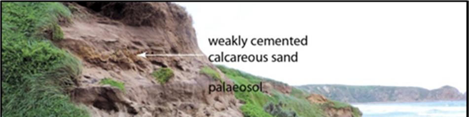
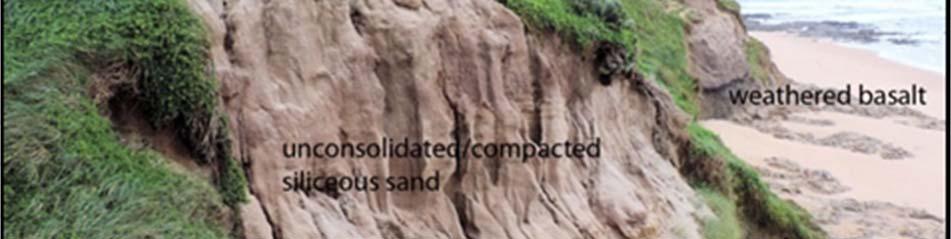
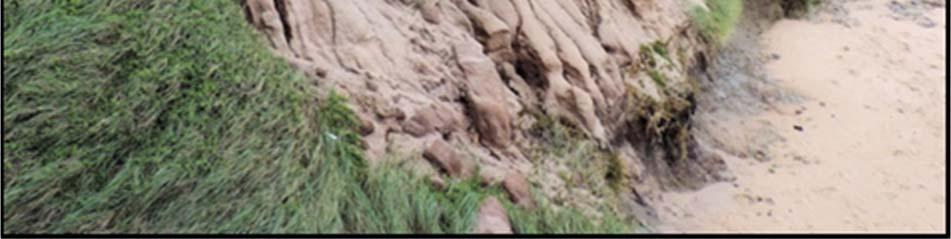
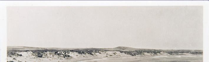
3 Coastal Geology Basaltic and fragmented lavas, granite at Pyramid Rock and Cape Woolamai Weathered basalt (>10m thick) covered in mix of sand and silt Limited accumulations of sand back from the shoreline Pyramid Rock
4 Coastal Geomorphology Continuously steep southern shoreline Broad & detailed character determined largely by physical character & structural variation in underlying basalt outcrops. No sand input from river. Coastal processes dominated by high wave energy. Aspect & exposure to wave action account for local variations in morphology.
5 Coastal Geomorphology Six major landform classes identified: Steep Coasts Shore Platforms Beaches, Dunes, Stream mouths, and Coastal Lagoons
6 Coastal Geomorphology
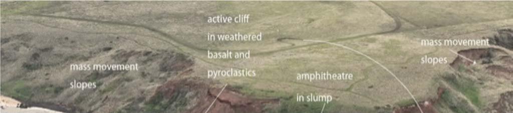
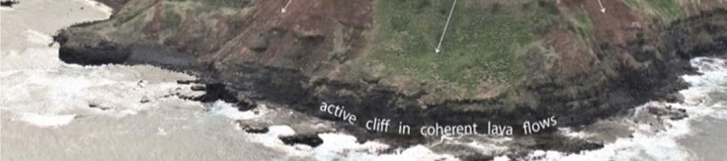
7 Coastal Geomorphology Landform classes: Steep coastline, with five major classes: Active Cliffs Active Mass Movement Slopes Bluffs Amphitheatres Plunging Cliffs
8 Coastal Geomorphology


9 Coastal Geomorphology
10 Coastal Geomorphology
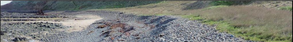
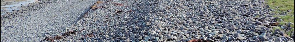
11 Coastal Geomorphology Landform classes: Shore Platforms Beaches: Boulder/cobble Cobble/gravel Sand Dunes Stream Mouths and Coastal Lagoons
12 Coastal Geomorphology


13 Coastal Geomorphology
14 Coastal Vegetation Determined by wind exposure, salt spray, soil composition, geology, presence of sea bird colonies and past land management practices. Dune vegetation affects dune development and morphology Introduced species more effective in binding sand. Important function when considering storm impacts on beaches and dunes
15 Oceangraphic Setting Winds & Waves Dune build-up: trapping by vegetation Local wind waves i.e. storm waves, typically erosive Swell waves Longer period, typically beach building Coastal Water Levels Storm surge Sea Level Rise
16 Coastal Processes susceptibility to erosion Landform Class Steep Coasts Active Cliffs Active mass movement slopes Current Susceptibility to Erosion Active Cliffs, particularly those in sands or weathered volcanics Only where marine processes interact with slope toe Potential Changes to Coastal & Terrestrial Processes with Sea Level Rise Increased frequency of wave impact at cliff base resulting in increased hydraulic action, abrasion, and mass movement. Increased wave impact through hydraulic action, abrasion, and mass movement. Likely Landform Response There will be selective change due to varied rock resistance of the different cliff materials. An increase in cliff slope is likely due to toe removal and increased slope failure. There is likely to be a loss of sandy beach and increase in gravel/boulder beach volume. There is likely to be a depletion of sandy beach areas, an increase in gravel/boulder beaches, a loss of vegetation on lower slopes, increased rate of slope failure and increased delivery of slope debris to the base of the slopes. Bluffs Amphithea tres Not currently active Not currently active Potential reactivation of base of inactive cliffs by wave impact. This is dependent on the width and volume of beach & dune areas fronting the bluffs. Potential reactivation of base of inactive cliffs by wave impact. Responses include the reactivation of currently stable slopes through the depletion of the beach and dune areas in front. This would likely result in mass movement of slopes occurring. Reactivation of currently stable slopes.
17 Coastal Processes susceptibility to erosion Beaches & Dunes Boulder, Erosion in cobble, response to storm gravel events beaches Sand beaches Dunes Erosion in response to storm events Erosion in response to storm events Increased inundation with higher wave energy. Increased abrasive action on platforms and cliffs. Increase in high energy events resulting in more dynamic beach environment. Increased inundation with higher wave energy. Those closest to the shoreline likely to experience: An increase in high energy events. Increased inundation with higher wave energy. Increased potential for weeds. Introduction of larger material sizes, but reduction of size of gravels, An increased width and steepness of gravel beaches. Recession of the shoreline, with migration landward of beach crest and berms. Increased rate of shoreline retreat. This occurs inversely proportional to beach slope, with gently sloping profiles retreating at a faster rate. There will likely be a decrease in the steepness of the beach and a narrowing of beach above the high tide mark. Increased overwash and scarping of berms. Erosion/retreat of foredunes, and loss of foredune vegetation. Initiation of blowouts.
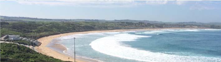
18 Coastal Processes Summerland Beach Coastal Processes Summerland Beach Sandy beach, formed in an embayment between 2 headlands. Cobble/gravel beaches at base of headlands. Beach profile varies, with narrow reflective high tide beach, Backshore comprises range of dune morpholigies.
19 Coastal Processes Summerland Beach Aerial imagery comparison ( ) & data analysis shows: Limited change in shoreline location Distinct landform changes due to increased vegetation cover. Short-term responses to storms (cliffing)


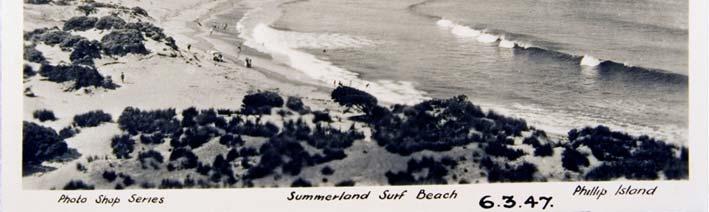


20 Coastal Processes Summerland Beach
21 Coastal Processes Summerland Beach Stand structures currently forward of shoreline Enhanced erosion due to stands
22 Coastal Processes Summerland Beach Trends: Recession of dune-beach profile with SLR On-going changes to dune morphology with vegetation, Short term responses to storm events will continue. May be enhanced under on-going SLR conditions, Coastal structures impacting erosion of beach-dune profile. Likely to increase with on-going SLR

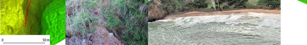
23 Coastal Processes Smiths Beach Fine sand beach, with headlands to west and east and very wide complex shore platform Backed by mass movement slope, minimal/no dunes present Limited sand supply
24 Coastal Processes Smiths Beach Aerial imagery comparison ( ) & data analysis shows: Increased exposure of the underlying cobble/gravel beaches, Increased exposure of an underlying thin cemented layer overlying weathered volcanic material (such as at the foot of the current access ramp), and Exposure and erosion at the foot of the backslope.


25 Coastal Processes Smiths Beach Mass movement slope
26 Coastal Processes Smiths Beach Mass movement slope
27 Coastal Processes Smiths Beach Trends: Backshore slope constrains landward movement, enhances sand loss from the beach Continued loss of sand, increasing exposure of toe of slope (may enhance sand movement) Reactivation of mass movement slope


28 Coastal Processes Woolamai Beach A long sandy beach backed by steeply rising slope Slope comprises active sand cliff as well as sections of mass movement slope Limited sources of sand inputs


29 Coastal Processes Woolamai Beach Localised change over the last 75 years Density of vegetation most marked change


30 Coastal Processes Woolamai Beach
31 Coastal Processes Woolamai Beach Dune heights have increased Reduced sand transport to Cleeland Bight Vegetation removal will reinitiate windblown sand transport Will not provide additional sand supply to Woolamai Beach
32 Coastal Processes Woolamai Beach Trends: Likely to be a net loss of sandy material from the beach with on-going sea level rise Potential reduction in sand fans in front of active sand cliffs Marine influences increasingly interact with toe of slope/cliff. Reactivation of failure surfaces and recessions initiated

33 Coastal Processes Management Strategies In line with the VCHS: Risk Avoidance Precautionary approach to new development, infrastructure or services, relocation of existing assets Risk Reduction Engineering works, planning and controls Risk Sharing Information and education of stakeholders
34 Coastal Processes Recommendations To build upon this work and inform future decision making: Long term monitoring program (could integrate with existing Surf Cam) Identify and quantify short and longer term changes to beaches, shorelines, surf Adaptive management approach in response to the on-going monitoring
Australian Coastal Councils Conference
 Australian Coastal Councils Conference 11 March 2015 Estimating Future Coastal Inundation and Erosion Hazards Dr Andrew McCowan Dr Christine Lauchlan-Arrowsmith Warwick Bishop Background Victorian Future
Geol 117 Lecture 18 Beaches & Coastlines. I. Types of Coastlines A. Definition:
 I. Types of Coastlines A. Definition: 1. Shore = narrow zone where ocean meets land (e.g. beach) 2. Coast is a broad area where both ocean and land processes act a. Includes onshore marshes, dunes, sea
1 Shoreline Landforms 2. 2 Emergent v. Submergent 2. 3 Wavecutting 3. 4 Planview 4. 5 Marine Terraces 5. 6 California 7. 7 Tombolos, Sea Stacks 8
 Shorelines November 9, 2008 Contents 1 Shoreline Landforms 2 2 Emergent v. Submergent 2 3 Wavecutting 3 4 Planview 4 5 Marine Terraces 5 6 California 7 7 Tombolos, Sea Stacks 8 8 Active Processes 9 9 Emergence
TECHNIQUES FOR ASSESSING COASTAL HAZARD AREAS FOR THE GISBORNE DISTRICT COAST
 TECHNIQUES FOR ASSESSING COASTAL HAZARD AREAS FOR THE GISBORNE DISTRICT COAST July 1994 C.R. 1994/12 Jeremy G Gibb 2009 All rights reserved. This work is entitled to the full protection given by the Copyright
1 Shoreline Erosion and Deposition
 CHAPTER 12 1 Shoreline Erosion and Deposition SECTION Agents of Erosion and Deposition BEFORE YOU READ After you read this section, you should be able to answer these questions: What is a shoreline? How
The Coast: Beaches and Shoreline Processes
 1 2 3 4 5 6 7 8 9 The Coast: es and Shoreline Processes Trujillo & Thurman, Chapter 10 Oceanography 101 Chapter Objectives Recognize the various landforms characteristic of beaches and coastal regions.
The Coast: Beaches and Shoreline Processes Trujillo & Thurman, Chapter 10
 The Coast: es and Shoreline Processes Trujillo & Thurman, Chapter 10 Oceanography 101 Chapter Objectives Recognize the various landforms characteristic of beaches and coastal regions. Identify seasonal
Weathering of Rocks. Weathering - Breakdown of rocks into pieces (sediment) 2 main types of weathering to rocks
 2 main types of weathering to rocks") Weathering of Rocks Weathering - Breakdown of rocks into pieces (sediment) 2 main types of weathering to rocks Mechanical weathering requires physical forces to break rocks into smaller pieces. Chemical
Weathering of Rocks Weathering - Breakdown of rocks into pieces (sediment) 2 main types of weathering to rocks Mechanical weathering requires physical forces to break rocks into smaller pieces. Chemical
Aim and objectives Components of vulnerability National Coastal Vulnerability Assessment 2
 ASSESSING THE UTILITY OF GEOMORPHIC SENSITIVITY MAPPING ON THE ILLAWARRA COAST Pamela Abuodha, Christina Baker, Chris Sharples, Darren Skene and Colin Woodroffe Geoquest Research Centre, University of
The Marine Environment
 The Marine Environment SECTION 16.1 Shoreline Features In your textbook, read about erosional landforms, beaches, estuaries, longshore currents, and rip currents. For each statement below, write true or
Black Point & Bihler Point
 Black Point & Bihler Point Conglomerate Photo: looking north toward end of Black Point (south of post 1) All of the rocks in this photo are conglomerate. Both Black Point and Bihler Point are formed from
Coastal Processes, Patterns and Associated Landforms, and Human Interaction
 Coastal Processes, Patterns and Associated Landforms, and Human Interaction Coastal processes, patterns and associated landforms Coastal processes and the impact of recreational pressures, coastal defence
Shoreline and Climate Change Adaptation Alternatives for The Letter Parcel, Bolinas Lagoon
 Shoreline and Climate Change Adaptation Alternatives for The Letter Parcel, Bolinas Lagoon Scenic shoreline vista of Bolinas Lagoon and ridges, from Letter Parcel, March 2016 Peter Baye, Coastal Ecologist
Coastal Erosion Landforms on the Gower Peninsula
 Geo Factsheet www.curriculum-press.co.uk Number 356 Coastal Erosion Landforms on the Gower Peninsula The Gower The rocky southern coast of the Gower Peninsula in South Wales is home to long stretches of
The Marine Environment
 The Marine Environment SECTION 16.1 Shoreline Features In your textbook, read about erosional landforms, beaches, estuaries, longshore currents, and rip currents. For each statement below, write or. 1.
A Generic Coastal Erosion Hazard Zoning for Tasmania. Chris Sharples, Hannah Walford & Luke Roberts April 2014
 A Generic Coastal Erosion Hazard Zoning for Tasmania Chris Sharples, Hannah Walford & Luke Roberts April 2014 Why do we need comprehensive coastal erosion hazard zones for Tasmania? Roches Beach 2011 Why
Ch 10 Deposition Practice Questions
 1. Base your answer to the following question on the data table below. Six identical cylinders, A through F, were filled with equal volumes of sorted spherical particles. The data table shows the particle
Sea-level Rise on Cape Cod: How Vulnerable Are We? Rob Thieler U.S. Geological Survey Woods Hole, MA
 Sea-level Rise on Cape Cod: How Vulnerable Are We? Rob Thieler U.S. Geological Survey Woods Hole, MA Outline Sea-level and coastal processes Past sea-level change Predictions for the future Coastal responses
Supplemental Slides. Shore: Junction of Land & Water. Junction of Land & Water. Sea Level Variations. Shore vs. Coast. Sea Level Variations
 Shore: Junction of Land & Water Supplemental Slides Sediments come off land Most get dumped at the beach Sediment interacts with ocean waves and currents Junction of Land & Water Features: Breaking waves,
Shore: Junction of Land & Water. Sediments come off land Most get dumped at the beach Sediment interacts with ocean waves and currents
 Shore: Junction of Land & Water Supplemental Slides Sediments come off land Most get dumped at the beach Sediment interacts with ocean waves and currents Junction of Land & Water Features: Breaking waves,
A Detailed First Pass coastal hazard assessment for a long complex coast: Kingborough LGA, Tasmania
 A Detailed First Pass coastal hazard assessment for a long complex coast: Kingborough LGA, Tasmania Chris Sharples & Paul Donaldson University of Tasmania September 2012 Kingborough LGA, south-eastern
COASTAL DYNAMICS VIRTUAL FIELD TRIP, NORTHEAST FLORIDA. Joann Mossa Department of Geography University of Florida
 COASTAL DYNAMICS VIRTUAL FIELD TRIP, NORTHEAST FLORIDA Joann Mossa Department of Geography University of Florida WHERE ARE WE GOING? In NE Florida (Flagler and St. Johns County, south of St. Augustine),
1. Which type of climate has the greatest amount of rock weathering caused by frost action? A) a wet climate in which temperatures remain below
 a wet climate in which temperatures remain below") 1. Which type of climate has the greatest amount of rock weathering caused by frost action? A) a wet climate in which temperatures remain below freezing B) a wet climate in which temperatures alternate
1. Which type of climate has the greatest amount of rock weathering caused by frost action? A) a wet climate in which temperatures remain below freezing B) a wet climate in which temperatures alternate
The Problem. Which ecosystems are the most sensitive? Where will ecosystems be migrating? Where will investments be overwhelmed?
 BC Parks BC Parks is responsible for the designation, management and conservation of a system of ecological reserves, provincial parks and recreation areas located throughout the province. British Columbia
Chapter 3 Erosion and Deposition. The Big Question:
 Chapter 3 Erosion and Deposition The Big Question: 1 Design a way to represent and describe the 4 types of mass movement. You may use pictures, diagrams, list, web, chart, etc 2 Chapter 3: Erosion and
Page 1. Name:
 Name: 1) Which event is the best example of erosion? dissolving of rock particles on a limestone gravestone by acid rain breaking apart of shale as a result of water freezing in a crack rolling of a pebble
Depositional Environment
 Depositional Environment Sedimentary depositional environment describes the combination of physical, chemical and biological processes associated with the deposition of a particular type of sediment. Types
Edexcel 2 Landscape systems, processes and change
 Edexcel 2 Landscape systems, processes and change Area of the Spec Field Site Research areas Primary data collection Secondary data access Statistical analysis High and low Identifying of different Local
Physical landscapes River landscapes in the UK
 Physical landscapes River landscapes in the UK The shape of river valleys change s as rivers flow downstream - PROCESSES Erosion Abrasion or corrasion Attrition Hydraulic Action Solution or corrosion Deposition
Erosion and Deposition
 CHAPTER 3 LESSON 2 Erosion and Deposition Landforms Shaped by Water and Wind Key Concepts What are the stages of stream development? How do water erosion and deposition change Earth s surface? How do wind
 Page 1 of 9 Name: Base your answer to the question on the diagram below. The arrows show the direction in which sediment is being transported along the shoreline. A barrier beach has formed, creating a
SHORELINE AND BEACH PROCESSES: PART 2. Implications for Coastal Engineering
 SHORELINE AND BEACH PROCESSES: PART 2 Implications for Coastal Engineering Objectives of the lecture: Part 2 Show examples of coastal engineering Discuss the practical difficulties of ocean engineering
Quantifying effects of oil on coastal dune vegetation. Thomas Miller and Elise Gornish Biological Science, Florida State University
 Quantifying effects of oil on coastal dune vegetation Thomas Miller and Elise Gornish Biological Science, Florida State University Natural History of Barrier Islands in the Northern Gulf Make up ~70% of
Term Knowledge Using and applying Grade Criteria Autumn 1 Assessment window October Natural hazards pose major risks to people and property.
 Assessment Schedule Year 9 2015/6 Term Knowledge Using and applying Grade Criteria Autumn 1 Assessment window October 2015 3.1.1.2 Tectonic Natural hazards pose major risks to people and property. Definition
Built Heritage & Archaeology Crown copyright. All rights reserved. Historic Scotland Licence No [2007] a
![Built Heritage & Archaeology Crown copyright. All rights reserved. Historic Scotland Licence No [2007] a](/thumbs/92/110316004.jpg "Built Heritage & Archaeology Crown copyright. All rights reserved. Historic Scotland Licence No [2007] a") : Tràigh an Tobair Fhuair to Meall Lamalum This map section stretches along s west coast from Tràigh an Tobair Fhuair to Meall Lamalum. The entire coastline comprises a rock platform, with the exception
: Tràigh an Tobair Fhuair to Meall Lamalum This map section stretches along s west coast from Tràigh an Tobair Fhuair to Meall Lamalum. The entire coastline comprises a rock platform, with the exception
Dunes Growth Estimation for Coastal Protection
 Dunes Growth Estimation for Coastal Protection Muhammad Zikra Department of Ocean Engineering, Faculty of Marine Technology, ITS, Kampus ITS Keputih Sukolilo, Surabaya 60111 Abstract: This paper describes
Day 3 Weathering and Erosion.notebook. October 02, Section 7.2. Erosion and Deposition. Objectives
 Objectives Describe the relationship of gravity to all agents of erosion. Contrast the features left from different types of erosion. Analyze the impact of living and nonliving things on the processes
Holderness Erosion and Evolution of the Spurn Peninsula
 Holderness Erosion and Evolution of the Spurn Peninsula Prof. Ken Pye and Dr. Simon Blott Kenneth Pye Associates Ltd. Outline of the Presentation Overview of historical erosion trends Effects of coast
EOLIAN PROCESSES & LANDFORMS
 EOLIAN PROCESSES & LANDFORMS Wind can be an effective geomorphic agent under conditions of sparse vegetation & abundant unconsolidated sediment egs. hot & cold deserts, beaches & coastal regions, glacial
What is weathering and how does it change Earth s surface? Answer the question using
 7 th Grade Lesson What is weathering and how does it change Earth s surface? Answer the question using the sentence frame. You have 4 minutes. Weathering is. This changes the Earth s surface because. 1
Coasts Key Word Glossary
 Coasts Key Word Glossary Abrasion Also known as corrosion. It is the wearing away of the cliff by sand, fragments of rock and boulders that are being hurled at the cliff by the waves. It causes grinding
Holocene evolution of Dahab coastline Gulf of Aqaba, Sinai Peninsula, Egypt 1
 Holocene evolution of Dahab coastline Gulf of Aqaba, Sinai Peninsula, Egypt 1 Magdy Torab* 2 * Prof. of Geomorphology, Department of Geography, Damanhour University, Egypt 3 E-mail: magdytorab@hotmail.com.
BUTE MAP 6: GARROCH HEAD to STRAVANNAN BAY
 BUTE MAP 6: GARROCH HEAD to STRAVANNAN BAY Hinterland Geology and Coastal Geomorphology: Old Red Sandstone and lavas form the principal base deposits and are overlain by marine deposits towards Port Dornoch.
Erosion and Deposition
 Erosion and Deposition Chapter Test A Multiple Choice Write the letter of the correct answer on the line at the left. 1. Water erosion begins when runoff from rainfall flows in a thin layer over the land
Coastal Processes and Shoreline Erosion on the Oregon Coast, Cascade Head to Cape Kiwanda
 State of Oregon Department of Geology and Mineral Industries Vicki S. McConnell, State Geologist Open File Report OFR O-04-11 Coastal Processes and Shoreline Erosion on the Oregon Coast, Cascade Head to
Summary Visualizations for Coastal Spatial Temporal Dynamics
 Summary Visualizations for Coastal Spatial Temporal Dynamics October 24 2011 Providence, RI Sidharth Thakur 1, Laura Tateosian 2, Helena Mitasova, Eric Hardin, and Margery Overton 1. sthakur@renci.org,
Sediment and Sedimentary rock
 Sediment and Sedimentary rock Sediment: An accumulation of loose mineral grains, such as boulders, pebbles, sand, silt or mud, which are not cemented together. Mechanical and chemical weathering produces
Map Introduction: South Uist Map 1
 96 Map Introduction: Map This map section covers part of the south coast of, including the head of the causeway which links the island to Eriskay. It extends from South Glen Dale to Taobh a'caolas. There
4. The map below shows a meandering stream. Points A, B, C, and D represent locations along the stream bottom.
 1. Sediment is deposited as a river enters a lake because the A) velocity of the river decreases B) force of gravity decreases C) volume of water increases D) slope of the river increases 2. Which diagram
EXTERNAL LAND FORMING PROCESSES
 NAME SCHOOL INDEX NUMBER DATE EXTERNAL LAND FORMING PROCESSES WEATHERING 1 1998 Q 7 (a) (i) What is the difference between weathering and mass wasting (ii) List five processes involved in chemical weathering
Erosion and Deposition
 Erosion and Deposition Erosion Sediment natural forces move rock/soil from one place to another. gravity, water, wind, glaciers, waves are causes material moved by erosion Deposition when erosion lays
5. MANY COASTAL COMMUNITIES AND FACILITIES WILL FACE INCREASING EXPOSURE TO STORMS.
 5. MANY COASTAL COMMUNITIES AND FACILITIES WILL FACE INCREASING EXPOSURE TO STORMS. Climate change is altering the Arctic coastline and much greater changes are projected for the future as a result of
Jasper Beach, Machiasport, Maine
 Maine Geologic Facts and Localities June, 2000 Jasper Beach, Machiasport, Maine 44 o 38 30.28 N, 67 o 22 31.96 W Text by Joesph T. Kelley, Department of Agriculture, Conservation & Forestry 1 Map by USGS
Map 12: Ayrshire Coast: Doonfoot Beach to Dunure Map Content Descriptions
 Map 12: Ayrshire Coast: Doonfoot Beach to Dunure Map Content Descriptions 1. Built Heritage and Archaeology A total of twenty three sites were located in the area covered by Map 12. Of these seventeen
Anticipation guide # 3
 Wind Anticipation guide # 3 Creep is a type of mass movement that happens slowly over many years Oxidation is a type of physical weathering A delta is a depositional feature that occurs with glaciers The
6. SURVEY MAPS OF THE ISLE OF ARRAN MAP 1: DRUMADOON POINT TO AIRD NAN RON
 6. SURVEY MAPS OF THE ISLE OF ARRAN MAP 1: DRUMADOON POINT TO AIRD NAN RON Hinterland Geology and Coastal Geomorphology: Both Permian sandstone and Triassic mudstones are represented in this coastal section.
2.2.7 Backbarrier flats
 FIGURE 24. VERTICAL PHOTOGRAPH SHOWING THE DEVELOPMENT OF SMALL PARABOLIC DUNES FROM BLOWOUTS IN A LARGE RELICT FOREDUNE NORTHWEST OF HUNTER'S CREEK. PHOTOGRAPH COURTESY OF CAR'T'ER HOLT HARVEY FORESTS
Figure 1 The map shows the top view of a meandering stream as it enters a lake. At which points along the stream are erosion and deposition dominant?
 1. In which type of climate does chemical weathering usually occur most rapidly? 1. hot and dry 3. cold and dry 2. hot and wet 4. cold and wet 2. Figure 1 The map shows the top view of a meandering stream
Chapter 17. Ocean and Coastal Processes
 Chapter 17 Ocean and Coastal Processes Ocean Basins and Plates Ocean Basins Ocean Basins are profoundly different from the continents. Ocean crust is thin and dense and young. New ocean crust is generated
Name Roy G Biv Page 1
 Name Roy G Biv Base your answers to questions 1 through 3 on the diagram below. The arrows show the direction in which sediment is being transported along the shoreline. A barrier beach has formed, creating
Pratice Surface Processes Test
 1. The cross section below shows the movement of wind-driven sand particles that strike a partly exposed basalt cobble located at the surface of a windy desert. Which cross section best represents the
Name. 4. The diagram below shows a soil profile formed in an area of granite bedrock. Four different soil horizons, A, B, C, and D, are shown.
 Name 1. In the cross section of the hill shown below, which rock units are probably most resistant to weathering? 4. The diagram below shows a soil profile formed in an area of granite bedrock. Four different
Presentation Outline. Project Overview. Sea Level Rise Assessment & Decision Tools. Community Engagement. Tina Whitman, Friends of the San Juans
 Healthy Beaches for People & Fish Sea Level Rise Adaptation Tools for San Juan County, WA Tina Whitman & Andrea MacLennan December 10, 2015 Presentation Outline Project Overview Tina Whitman, Friends of
1. Erosion by Running Water Most powerful cause of erosion
 I. Destructive Forces Notes: Destructive force: a process in which land is destroyed or changed such as weathering and erosion. All landforms are a result of a combination of constructive and destructive
Erosion and Deposition
 Erosion and Deposition The Erosion-Deposition Process What do you think? Read the two statements below and decide whether you agree or disagree with them. Place an A in the Before column if you agree with
MEMORANDUM FOR SWG
 MEMORANDUM FOR SWG-2007-1623 Subject: Jurisdictional Determination (JD) for SWG-2007-1623 on Interdunal Wetlands Adjacent to Traditional Navigable Waters (TNWs) Summary The U.S. Environmental Protection
Coastal Systems and Landscapes
 AQA Geography A-level Coastal Systems and Landscapes PMT Education Written by Jeevan Singh Coastal Systems and Landscapes Features of Coastal Zones Coastal zones develop from interactions between the winds,
GLY Coastal Geomorphology Notes
 GLY 4734 - Coastal Geomorphology Notes Dr. Peter N. Adams Spring 2011 2 Coastal Classification In this lecture, we discuss some successful classification schemes of the coastal landscape, and pay particular
DIVISION OF COASTAL MANAGEMENT TO STUDY CURRENT LONG-TERM EROSION RATES ADJACENT TO TERMINAL GROINS
 DIVISION OF COASTAL MANAGEMENT TO STUDY CURRENT LONG-TERM EROSION RATES ADJACENT TO TERMINAL GROINS North Carolina Department of Environmental Quality Division of Coastal Management February 22, 2018 N.
Importance of Understanding Coastal Landforms
 Importance of Understanding Coastal Landforms Costa Concordia Shipwreck, Isola del Giglio, Italy Depositional Coastal Landforms Can interpret landforms in light of geomorphic processes, both terrestrial
Coastal Study Delimara Peninsula
 Coastal Study Delimara Peninsula Edward Gilson Fieldwork Report Coastal Study Coastal Processes Delimara Peninsula Location:. Date: Time:. Apparatus:. Weather Conditions: Objectives / Aims: Geography Option
Essential Questions. What is erosion? What is mass wasting?
 Erosion Essential Questions What is erosion? What is mass wasting? What is Erosion? Erosion The transportation of sediment from one area to another Caused mainly by running water but also caused by glaciers,
Chapter 16. Oceans, Shorelines, and Shoreline Processes
 Chapter 16 Oceans, Shorelines, and Shoreline Processes Introduction Oceans and seas cover 71% of the Earth's surface. Geologic evidence indicates that the Earth has had oceans for at least 3.5 billion
COASTLINES MARINE EROSION PROCESSES. Read the course booklet.
 MARINE EROSION Read the course booklet. PROCESSES. You will need to know and be able to explain the four methods of coastal erosion and two of weathering The next few slides illustrate these processes.
Mapping of Future Coastal Hazards. for Southern California. January 7th, David Revell, Ph.D. E.
 Mapping of Future Coastal Hazards for Southern California January 7th, 2014 David Revell, Ph.D. drevell@esassoc.com E. Vandebroek, 2012 Outline Coastal erosion hazard zones Flood hazard zones: Coastal
MAP 14: VALLAY ISLAND. Hinterland Geology and Coastal Geomorphology:
 MAP 14: VALLAY ISLAND Hinterland Geology and Coastal Geomorphology: The Vallay strand and island are a conspicuous landscape element within this area. The island is largely sand-covered and consists of
Map Introduction: South Uist Map 6
 6 Map Introduction: Map 6 This map section covers part of the west coast of. It extends from Cill Donnain to Ardvule and onwards to Ormacleit. There is no modern settlement within the coastal zone but
1/6/ th Grade Earth s Surface. Chapter 3: Erosion and Deposition. Lesson 1 (Mass Movement)
") Lesson 1 (Mass Movement) 7 th Grade Earth s Surface Chapter 3: Erosion and Deposition Weathering the chemical and physical processes that break down rock at Earth s surface Mechanical weathering when rock
Lesson 1 (Mass Movement) 7 th Grade Earth s Surface Chapter 3: Erosion and Deposition Weathering the chemical and physical processes that break down rock at Earth s surface Mechanical weathering when rock
Working with Natural Stream Systems
 Working with Natural Stream Systems Graydon Dutcher Delaware County Soil & Water Conservation District Stream Corridor Management Program Tropical Storm Sandy October 29,2012 What is a Watershed?
EROSION HAZARD OF MINNESOTA'S LAKE SUPERIOR SHORELINE. Carol A. Johnston Principal Investigator
 EROSION HAZARD OF MINNESOTA'S LAKE SUPERIOR SHORELINE Carol A. Johnston Principal Investigator Maps prepared by: James Salés, John Bonde, Tim Aunan, and Richard Raby Minnesota Sea Grant Research Bulletin
Developed in Consultation with Florida Educators
 Developed in Consultation with Florida Educators Table of Contents Next Generation Sunshine State Standards Correlation Chart... 7 Benchmarks Chapter 1 The Practice of Science...................... 11
L.O: SLOWING STREAMS DEPOSIT (SORT) SEDIMENT HORIZONTALLY BY SIZE.
 SEDIMENT HORIZONTALLY BY SIZE.") L.O: SLOWING STREAMS DEPOSIT (SORT) SEDIMENT HORIZONTALLY BY SIZE. 1. Base your answer to the following question on the profile shown below, which shows the pattern of horizontal sorting produced at a
L.O: SLOWING STREAMS DEPOSIT (SORT) SEDIMENT HORIZONTALLY BY SIZE. 1. Base your answer to the following question on the profile shown below, which shows the pattern of horizontal sorting produced at a
Name: Which rock layers appear to be most resistant to weathering? A) A, C, and E B) B and D
 A, C, and E B) B and D") Name: 1) The formation of soil is primarily the result of A) stream deposition and runoff B) precipitation and wind erosion C) stream erosion and mass movement D) weathering and biological activity 2)
Name: 1) The formation of soil is primarily the result of A) stream deposition and runoff B) precipitation and wind erosion C) stream erosion and mass movement D) weathering and biological activity 2)
Changing Earth s Surface
 Name Date Class Changing Earth s Surface What processes wear down and build up Earth s surface? What causes the different types of mass movement? Erosion is the process by which natural forces move weathered
UNIT 3 GEOLOGY VOCABULARY FLASHCARDS THESE KEY VOCABULARY WORDS AND PHRASES APPEAR ON THE UNIT 3 CBA
 UNIT 3 GEOLOGY VOCABULARY FLASHCARDS THESE KEY VOCABULARY WORDS AND PHRASES APPEAR ON THE UNIT 3 CBA A map that shows Earth s Topographic Map surface topography, which is Earth s shape and features Contour
Map 4: Cowal Peninsula: Cluniter to Ardyne Point Map Content Descriptions
 Map 4: Cowal Peninsula: Cluniter to Ardyne Point Map Content Descriptions 1. Built Heritage and Archaeology A total of twenty four sites were recorded in the area covered by Map 4. Of these six were previously
Weathering, Erosion and Deposition
 Weathering, Erosion and Deposition Shaping the Earth s Surface Weathering the process of breaking down rocks into smaller fragments Erosion the transport of rock fragments from one location to another
Read Across America. Listen as I read for facts about Volcanoes. In the Shadow of the Volcano
 Read Across America Listen as I read for facts about Volcanoes. In the Shadow of the Volcano Constructive & Destructive Processes Earth s surface is always changing. Blowing wind and flowing water causes
OVERWASHED SEDIMENT INTO THE GAMO LAGOON IN NANAKITA RIVER MOUTH AND EFFECTIVENESS OF THE OVERWASH PREVENTION CONSTRUCTION
 東北地域災害科学研究第 6 巻 (010) 191 OVERWASHED SEDIMENT INTO THE GAMO LAGOON IN NANAKITA RIVER MOUTH AND EFFECTIVENESS OF THE OVERWASH PREVENTION CONSTRUCTION ABSTRACT Xuan Tinh Nguyen 1, Ryutaro Hirao, Hitoshi
core mantle crust the center of the Earth the middle layer of the Earth made up of molten (melted) rock
 rock") core the center of the Earth mantle the middle layer of the Earth made up of molten (melted) rock crust the surface layer of the Earth that includes the continents and oceans 1 continental drift the theory
core the center of the Earth mantle the middle layer of the Earth made up of molten (melted) rock crust the surface layer of the Earth that includes the continents and oceans 1 continental drift the theory
II Why study coastal landforms?
 COASTAL LANDFORMS (32) I Main topics A Why study coastal landforms? B Sediment budget and system response C Coastal landforms 3/26/15 GG454 1 II Why study coastal landforms? A Dynamic systems B Reflect
COASTAL GEOLOGIC HAZARDS AND SEA-LEVEL RISE: CLIMATE CHANGE IN RHODE ISLAND
 COASTAL GEOLOGIC HAZARDS AND SEA-LEVEL RISE: CLIMATE CHANGE IN RHODE ISLAND Sakonnet Preservation Association Annual Meeting 9 July 2013 Jon C. Boothroyd 1,2 and Bryan A. Oakley 3 (1) Rhode Island Geological
The use of MIKE21 to study the. barrier beach system of Inner Dingle Bay, Co. Kerry, Ireland. Dr. Michael O Shea Malachy Walsh and Partners
 The use of MIKE21 to study the morphodynamic evolution of the mid-bay barrier beach system of Inner Dingle Bay, Co. Kerry, Ireland Dr. Michael O Shea Malachy Walsh and Partners Contents Why Study Morphodynamics
Seaton to Seaton Hole SUMMARY OF PREFERRED PLAN RECOMMENDATIONS AND JUSTIFICATION
 Location reference: Policy Unit reference: Plan: Seaton to Seaton Hole 6a29 and 6a30 SUMMARY OF PREFERRED PLAN RECOMMENDATIONS AND JUSTIFICATION The large number of properties and assets at risk in the
Quantifying Coastal Evolution using Remote Sensing Approaches
 Quantifying Coastal Evolution using Remote Sensing Approaches Sojan Mathew, Linh Truong Hong, Xavier Pellicer*, Colman Gallagher University College Dublin Geological Survey of Ireland* INFOMAR SEMINAR,
Ocean and Coastal Processes. Ocean Basins. Chapter 20. Ocean Basins and Plates. Ocean Terms. Sea Arch Bay-mouth Bar Spit Tombolo Coast.
 Chapter 20 Ocean Basins and Plates Ocean and Coastal Processes Tide Wave Height Length Period Base Refraction Tsunami Beach Sea stack Ocean Terms Sea Arch Bay-mouth Bar Spit Tombolo Coast Emergent Submergent
PEKA PEKA FIVE YEAR RESTORATION PLAN
 PEKA PEKA FIVE YEAR RESTORATION PLAN BACKGROUND Pekapeka is located on the Kapiti Coast between Te Horo in the north and Waikanae to the south. The dune area is a Kapiti Coast District Council (KCDC) reserve.
Figure 45. Plan of Pukaroro drawn from aerial photograph. K. Jones, drawn by C. Edkins, DOC.
 Figure 45. Plan of Pukaroro drawn from aerial photograph. K. Jones, drawn by C. Edkins, DOC. 101 length, and there are cross-rows forming semi-enclosures. House floors are also present at the southern
Cliff stabilisation. Adaptation Option Climate-ADAPT
 Cliff stabilisation Adaptation Option Climate-ADAPT Cover design: EEA Cover photo: EEA Layout: EEA Legal notice The contents of this publication do not necessarily reflect the official opinions of the
Coastal Vulnerability and Risk Parameters
 European Water 11/12: 3-7, 2005. 2005 E.W. Publications Coastal Vulnerability and Risk Parameters E. Doukakis National Technical University of Athens-Dept. of Rural and Surveying Engineering, Lab. of Higher