The Erosion Problem: Perspectives. Physical
|
|
|
- Rosa Summers
- 5 years ago
- Views:
Transcription


1 Greg Berman

2 The Erosion Problem: Perspectives Physical Education Regulation
3 The Erosion Problem: Physical Perspectives What is a hotspot? Erosion Rate / Vulnerability / Frame of Reference


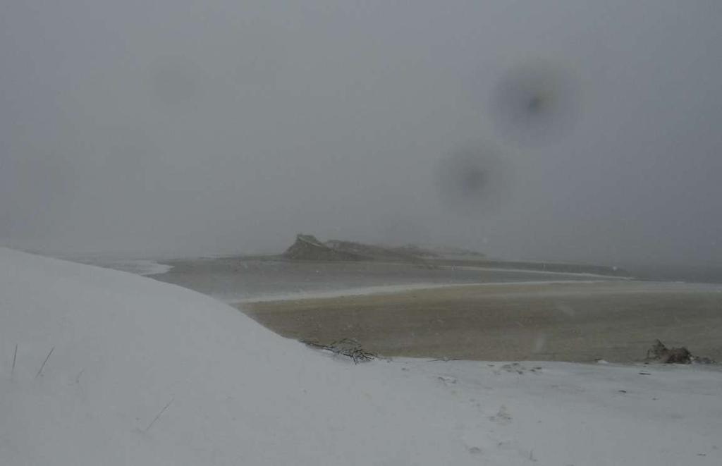
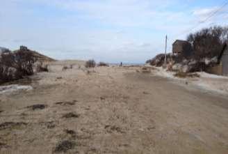
4 Sandwich Town Neck January 26, 2015


5 Video by Peter Traykovski, WHOI Sandwich Town Neck January 26, 2015


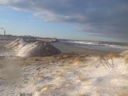
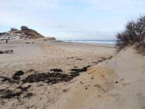
6 Sandwich Town Neck Video by Peter Traykovski, WHOI, Image by Issac Benaka January 27, 2015 February, 2015


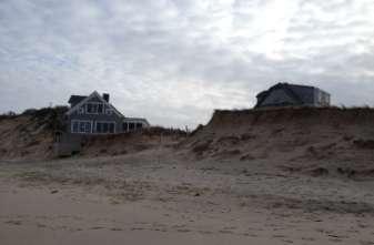
7 February 6, 2015 The Erosion Problem: Dennis July 30, 2015


8 The Erosion Problem: Truro

9 The Erosion Problem: Education Perspectives It s all sediment transport! What is Erosion???... just more leaving than coming in Accretion Static Equilibrium Erosion

10 Daily/Seasonal Variability Beach Profile Adjustments Large waves, which tend to occur in the winter in Massachusetts, cause the beach to temporarily change its profile. Winter Summer Images adapted from Natural Hazard Considerations for Purchasing Coastal Real Estate in Hawaii - A Practical Guide of Common Questions and Answers, by University of Hawaii Sea Grant College Program, 2006.
11 General Coastal Processes
12 Coastal Processes: Why they matter 70 80% of MA shoreline is eroding Erosion rates have increased since 1950 s Erosion is not steady punctuated by storms (layers exposed can cause slumping)
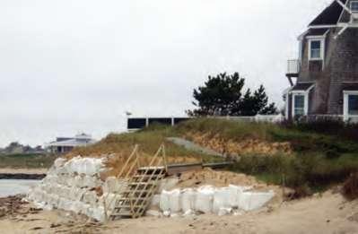
13 Erosion Control Structures Designed to extend the usable life of a property. General practice 1920s 1950s. Scientists wrote letter in 1970 s... MA needs erosion. 310 CMR 10: no new coastal engineering structure on a coastal beach/dune/bank to protect a structure built after 8/10/1978 Towns: Engineered structures may require nourishment


14 Coastal Processes: Key Points 1. Erosion of glacial landforms is the MOST important source of sediment for dunes and beaches in Massachusetts. 2. Wind and waves then transport sediment. 3. Without erosion and then longshore re-deposition there would be no beaches.
15 The Spectrum of Coastal Erosion Control Methods Do nothing Vegetation Re-grade Managed retreat Beach nourishment Sand fencing Fiber rolls Coir Envelopes C E S WPA: Coastal engineering structure means, but is not limited to, any breakwater, bulkhead, groin, jetty, revetment, seawall, weir, riprap or any other structure that is designed to alter wave, tidal or sediment transport processes in order to protect inland or upland structures from the effects of such processes.

16 The Erosion Problem: Regulatory / Legal Perspectives Stick vs. Carrot Regulations Incentives

17 The Erosion Problem: Educational Perspectives Scientists Public Childhood Vaccines: 86% 68% PEW Climate Change: 87% 50% GMO: 88% 37% High 90s%, if look at literature Cook et al 2013, IPCC 5th AR


18 The Erosion Problem: Educational Perspectives Coastal Property Owner Coastal Resource User Preserve upland Preserve CRA width Revetment Green Infrastructure Nourishment trigger at local beach elevation Nourishment is annual volume for downdrift beaches


19 The Erosion Problem: Educational Perspectives Grandfathering.pre/post 1978 Buyer beware Remove grandfathering or drop the 1978 restriction on CES Right now we ve got 2 classes of property NFIP tried to remove grandfathering BW12 Lose grandfathering on change in ownership (2 nd homes 1 st )
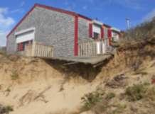
20 The Erosion Problem: Regulatory / Legal Perspectives 1. Post 1978 house 2. Scarp from house 3. Poorly maintained fiber rolls 4. Several OOCs included no CES Is it acting as a sediment source?...only needs to play a role. Local ConCom permitted a rock revetment (CES). Abutters/Stakeholders appealed to State DEP
21 The Erosion Problem: Regulatory / Legal Perspectives 1. Mix of Pre and Post 1978 houses 2. Scarp 5-50 from houses 3. Revegetation of coastal bank attempted 4. Several OOCs included no CES 5. Town owned conservation land 6. Beach had Wetlands Restriction Act 7. Erosion down drift Is it acting as a sediment source?...only needs to play a role. Local ConCom denied project. Likely changes/appeal coming soon. No you don t understand my house is going to fall in!


22 The Erosion Problem: Regulatory / Legal Perspectives Temporary Measures


23 The Erosion Problem: Regulatory / Legal Perspectives

24 Why not eminent domain? Why protect properties..? Town of Brewster example The Facts Value = $333,000,000 Only ~1% of properties ~3% of town area but they make ~10% of the real estate taxes The Implications (don t want takings) To keep the same revenue, the tax rate would go from 8.18 to 9.06 or ~$300 per household
25 Questions? Greg Berman Coastal Processes Specialist Woods Hole Sea Grant Cape Cod Cooperative Extension
Coastal Processes 101. Greg Berman (Woods Hole Sea Grant & Cape Cod Cooperative Extension)
") Coastal Processes 101 Greg Berman (Woods Hole Sea Grant & Cape Cod Cooperative Extension) January 23, 2019 Coastal Processes 101 Outline: ~30 min talk Coastal Processes What is Erosion? Value of the Ecosystem
Coastal Processes 101 Greg Berman (Woods Hole Sea Grant & Cape Cod Cooperative Extension) January 23, 2019 Coastal Processes 101 Outline: ~30 min talk Coastal Processes What is Erosion? Value of the Ecosystem
Coastal Processes 101 & The Regs. Greg Berman (Woods Hole Sea Grant & Cape Cod Cooperative Extension)
") Coastal Processes 101 & The Regs Greg Berman (Woods Hole Sea Grant & Cape Cod Cooperative Extension) March 26, 2019 Coastal Processes 101 & The Regs Outline: ~15 min talk Coastal Processes What is Erosion?
Coastal Processes 101 & The Regs Greg Berman (Woods Hole Sea Grant & Cape Cod Cooperative Extension) March 26, 2019 Coastal Processes 101 & The Regs Outline: ~15 min talk Coastal Processes What is Erosion?
Connecticut Coastal Management Program
 Connecticut Coastal Management Program Fact Sheet for SHORELINE FLOOD AND EROSION CONTROL STRUCTURES What are Shoreline Flood and Erosion Control Structures? The Connecticut General Statutes (CGS) define
ARE WE PROTECTING THE BENEFICIAL FUNCTIONS OF COASTAL LANDFORMS? AN ANALYSIS OF ACTIVITIES PERMITTED ON COASTAL LANDFORMS ON CAPE COD IN 1999
 ARE WE PROTECTING THE BENEFICIAL FUNCTIONS OF COASTAL LANDFORMS? AN ANALYSIS OF ACTIVITIES PERMITTED ON COASTAL LANDFORMS ON CAPE COD IN 1999 James F. O Connell, WHOI Sea Grant & Cape Cod Cooperative Extension
SHORELINE AND BEACH PROCESSES: PART 2. Implications for Coastal Engineering
 SHORELINE AND BEACH PROCESSES: PART 2 Implications for Coastal Engineering Objectives of the lecture: Part 2 Show examples of coastal engineering Discuss the practical difficulties of ocean engineering
Coastal Processes and Shoreline Erosion on the Oregon Coast, Cascade Head to Cape Kiwanda
 State of Oregon Department of Geology and Mineral Industries Vicki S. McConnell, State Geologist Open File Report OFR O-04-11 Coastal Processes and Shoreline Erosion on the Oregon Coast, Cascade Head to
Controlling Processes That Change Land
 1 Name Date Controlling Processes That Change Land People try to control some of the processes that change land. To do this, people apply technology- the use of science to solve problems in everyday life.
Geol 117 Lecture 18 Beaches & Coastlines. I. Types of Coastlines A. Definition:
 I. Types of Coastlines A. Definition: 1. Shore = narrow zone where ocean meets land (e.g. beach) 2. Coast is a broad area where both ocean and land processes act a. Includes onshore marshes, dunes, sea
Assessing Sea Level Rise, Storm Surge and Flooding Risks at the Ogunquit Wastewater Treatment Facility COMMITMENT & INTEGRITY DRIVE RESULTS
 Assessing Sea Level Rise, Storm Surge and Flooding Risks at the Ogunquit Wastewater Treatment Facility September 27, 2012 Presentation Outline Reasons for the Study Sea Level Rise, Storm Surge & Flooding
Protecting the Storm Damage Prevention and Flood Control Interests of Coastal Resource Areas
 Protecting the Storm Damage Prevention and Flood Control Interests of Coastal Resource Areas Presented by: Massachusetts Department of Environmental Protection & Massachusetts Office of Coastal Zone Management
Shoreline and Climate Change Adaptation Alternatives for The Letter Parcel, Bolinas Lagoon
 Shoreline and Climate Change Adaptation Alternatives for The Letter Parcel, Bolinas Lagoon Scenic shoreline vista of Bolinas Lagoon and ridges, from Letter Parcel, March 2016 Peter Baye, Coastal Ecologist
Sea-level Rise on Cape Cod: How Vulnerable Are We? Rob Thieler U.S. Geological Survey Woods Hole, MA
 Sea-level Rise on Cape Cod: How Vulnerable Are We? Rob Thieler U.S. Geological Survey Woods Hole, MA Outline Sea-level and coastal processes Past sea-level change Predictions for the future Coastal responses
Coastal Sediment Transport
 Coastal & Marine Coastal Sediment Transport Mazen Abualtayef Assistant Prof., IUG, Palestine Sediment Transport Sediment is any particulate matter that can be transported by fluid flow and which eventually
SEGMENTED BREAKWATERS AND THEIR USE IN COASTAL LOUISIANA
 SEGMENTED BREAKWATERS AND THEIR USE IN COASTAL LOUISIANA Prepared by: Louisiana Coastal Protection and Restoration Authority Engineering Division March 2016 The geology of Louisiana s coastal zone is intimately
GCSE 4242/02 GEOGRAPHY (Specification B) FOUNDATION TIER UNIT 2 SECTION B
 FOUNDATION TIER UNIT 2 SECTION B") Surname Centre Number Candidate Number Other Names 0 GCSE 4242/02 GEOGRAPHY (Specification B) FOUNDATION TIER UNIT 2 SECTION B S15-4242-02 P.M. WEDNESDAY, 3 June 2015 1 hour 30 minutes For s use Part Maximum
Surname Centre Number Candidate Number Other Names 0 GCSE 4242/02 GEOGRAPHY (Specification B) FOUNDATION TIER UNIT 2 SECTION B S15-4242-02 P.M. WEDNESDAY, 3 June 2015 1 hour 30 minutes For s use Part Maximum
KEYWORDS: erosion shoreline change nourishment community issues
 UNC Coastal Studies Institute 1 TITLE: Sand, Soil, Sediment Selection for Beach Nourishment KEYWORDS: erosion shoreline change nourishment community issues ABSTRACT: North Carolina s barrier islands are
Analysis of the Coastal Protection Experience. in Three Towns on Cape Cod, Massachusetts
 Analysis of the Coastal Protection Experience in Three Towns on Cape Cod, Massachusetts A thesis Submitted by Peter T. Kelly-Joseph In partial fulfillment of the requirements for the degree of Master of
Weathering of Rocks. Weathering - Breakdown of rocks into pieces (sediment) 2 main types of weathering to rocks
 2 main types of weathering to rocks") Weathering of Rocks Weathering - Breakdown of rocks into pieces (sediment) 2 main types of weathering to rocks Mechanical weathering requires physical forces to break rocks into smaller pieces. Chemical
Weathering of Rocks Weathering - Breakdown of rocks into pieces (sediment) 2 main types of weathering to rocks Mechanical weathering requires physical forces to break rocks into smaller pieces. Chemical
Virginia Shoreline Mapping Tools
 Virginia Shoreline Mapping Tools December 15, 2017 Karen Duhring Center for Coastal Resources Management Virginia Institute of Marine Science College of William & Mary Virginia Shoreline Mapping Tools
Term Knowledge Using and applying Grade Criteria Autumn 1 Assessment window October Natural hazards pose major risks to people and property.
 Assessment Schedule Year 9 2015/6 Term Knowledge Using and applying Grade Criteria Autumn 1 Assessment window October 2015 3.1.1.2 Tectonic Natural hazards pose major risks to people and property. Definition
The Marine Environment
 The Marine Environment SECTION 16.1 Shoreline Features In your textbook, read about erosional landforms, beaches, estuaries, longshore currents, and rip currents. For each statement below, write or. 1.
Coastal Erosion in Daniel s Harbour
 PT-13: Coastal and Ocean Engineering ENGI.8751 Undergraduate Student Forum Faculty of Engineering and Applied Science, Memorial University, St. john s, NL, Canada March, 2013 Paper Code. (PT-13-Luther)
4.2 Tidal Wetlands. Phragmites Australis
 4.2 Tidal Wetlands Few topics elicit such strong emotions in Guilford as the current state of salt marshes. These marshes, more broadly known as tidal wetlands, are undergoing a transformation as sea level
Supplemental Slides. Shore: Junction of Land & Water. Junction of Land & Water. Sea Level Variations. Shore vs. Coast. Sea Level Variations
 Shore: Junction of Land & Water Supplemental Slides Sediments come off land Most get dumped at the beach Sediment interacts with ocean waves and currents Junction of Land & Water Features: Breaking waves,
Shore: Junction of Land & Water. Sediments come off land Most get dumped at the beach Sediment interacts with ocean waves and currents
 Shore: Junction of Land & Water Supplemental Slides Sediments come off land Most get dumped at the beach Sediment interacts with ocean waves and currents Junction of Land & Water Features: Breaking waves,
Protection of Coasts
 Protection of Coasts [Coastal Zones] Jan van de Graaff Delft University of Technology 1 Coastal Zone: many definitions here: rather narrow strip of land adjacent to sea or large inland water (say: 150
The Marine Environment
 The Marine Environment SECTION 16.1 Shoreline Features In your textbook, read about erosional landforms, beaches, estuaries, longshore currents, and rip currents. For each statement below, write true or
The Coast: Beaches and Shoreline Processes
 1 2 3 4 5 6 7 8 9 The Coast: es and Shoreline Processes Trujillo & Thurman, Chapter 10 Oceanography 101 Chapter Objectives Recognize the various landforms characteristic of beaches and coastal regions.
Bob Van Dolah. Marine Resources Research Institute South Carolina Department of Natural Resources
 Bob Van Dolah Marine Resources Research Institute South Carolina Department of Natural Resources Shoreline Change Will Occur! On our front beaches where it is not easy to retreat Shoreline Change Will
Numerical models in context of coastal climate change, adaptation and protection schemes. Nils Drønen Head of Innovation, CED, DHI
 Numerical models in context of coastal climate change, adaptation and protection schemes Nils Drønen Head of Innovation, CED, DHI Agenda Introduction How can we quantify coastal response to climate change
The Coast: Beaches and Shoreline Processes Trujillo & Thurman, Chapter 10
 The Coast: es and Shoreline Processes Trujillo & Thurman, Chapter 10 Oceanography 101 Chapter Objectives Recognize the various landforms characteristic of beaches and coastal regions. Identify seasonal
Scenarios for the NI coast in the 21 st Century
 Scenarios for the NI coast in the 21 st Century Prof Julian Orford Geography, Archaeology & Palaeoecology Queen s University, Belfast Challenging perspective Living by the coast is good for your health!
Shoreline Mapping & Erosion Patterns. Julia Knisel Julia Knisel Coastal Shoreline & Floodplain Manager
 Shoreline Mapping & Erosion Patterns Along the Massachusetts Coast Julia Knisel Julia Knisel Coastal Shoreline & Floodplain Manager CZM Shoreline Change Project Timeline 1989: produced coast wide maps
Adaptation to Sea Level Rise A Regional Approach
 Adaptation to Sea Level Rise A Regional Approach Project Partners: in Saco Bay, ME Peter Slovinsky, Marine Geologist Maine Geological Survey, Department of Conservation Project Funding from: Saco Bay Hazards
Developed in Consultation with Florida Educators
 Developed in Consultation with Florida Educators Table of Contents Next Generation Sunshine State Standards Correlation Chart... 7 Benchmarks Chapter 1 The Practice of Science...................... 11
26 Coastal erosion and accretion
 26 Coastal erosion and accretion 26.1 Rate of erosion and accretion 26.2 Length of protected coastline 26.3 Volume of sand nourishment Fig. 26.1: Coastline dynamics of the South East Baltic region Key
VOLUNTEER GUIDE Updated June 2018
 VOLUNTEER GUIDE Updated June 2018 TABLE OF CONTENTS Why this project?... 3 About Illinois Lake Michigan Coast...4 Key Terms & Definitions... 5 Monitoring Locations... 6 Monitoring Survey Protocol... 6
Professors Dean and Dalrymple are also authors of the well-known Water Wave Mechanics for Engineers and Scientists.
 COASTAL PROCESSES The world s coastlines, dividing land from sea, are geological environments unique in their composition and the physical processes affecting them. Humans have been building structures
21st International Conference of The Coastal Society LEGAL AND POLICY IMPACTS OF SEA LEVEL RISE TO BEACHES AND COASTAL PROPERTY
 21st International Conference of The Coastal Society LEGAL AND POLICY IMPACTS OF SEA LEVEL RISE TO BEACHES AND COASTAL PROPERTY Megan Higgins, Roger Williams University School of Law and RI Sea Grant Legal
DIVISION OF COASTAL MANAGEMENT TO STUDY CURRENT LONG-TERM EROSION RATES ADJACENT TO TERMINAL GROINS
 DIVISION OF COASTAL MANAGEMENT TO STUDY CURRENT LONG-TERM EROSION RATES ADJACENT TO TERMINAL GROINS North Carolina Department of Environmental Quality Division of Coastal Management February 22, 2018 N.
Sea-level Rise and Storm Effects on Coastal Systems under Changing Global Climate. Cape May, NJ 12 January 2009
 Sea-level Rise and Storm Effects on Coastal Systems under Changing Global Climate 2009 Delaware Estuary Science Summit Cape May, NJ 12 January 2009 S. Jeffress Williams Senior Coastal Marine Geologist
COASTAL HAZARDS. Alan Lulloff, Water Management Engineer Wisconsin Department of Natural Resources. Local Contact: John Spangberg (715)
") COASTAL HAZARDS Alan Lulloff, Water Management Engineer Wisconsin Department of Natural Resources Local Contact: John Spangberg (715)685-2923 The Northwest Ordinance of 1787 and the river Mississippi and
COASTAL HAZARDS Alan Lulloff, Water Management Engineer Wisconsin Department of Natural Resources Local Contact: John Spangberg (715)685-2923 The Northwest Ordinance of 1787 and the river Mississippi and
Sea Level Rise and the Scarborough Marsh Scarborough Land Trust Annual Meeting April 24, 2018
 Sea Level Rise and the Scarborough Marsh Scarborough Land Trust Annual Meeting April 24, 2018 Peter A. Slovinsky, Marine Geologist Maine Geological Survey Funded by: 50% 40% Figure modified from Griggs,
Coastal issues: Beaches and Estuaries
 Coastal issues: Beaches and Estuaries Definitions: Coast = broad zone where both marine & terrestrial processes act It includes the beach, lagoons, marshes, bars etc. Coastal processes act to shape the
Environment Bay of Plenty Ohope Beach system
 Environment Bay of Plenty 7 5. Ohope Beach system Environmental Publication 27/ NERMN Beach Profile Monitoring Environment Bay of Plenty 5..1 Ohope Spit (CCS 9) Discussion The site is located 2m to the
Planning for coastal hazards in a changing climate
 March 2013 Planning for coastal hazards in a changing climate Catherine Knight, Coastal and Estuary Officer Sharyn French, Manager Land and Natural Environment Presentation overview Stormy past Council
A Perfect Storm: The Collision of Tropical Cyclones, Climate Change and Coastal Population Growth. Jeff Donnelly Woods Hole Oceanographic Institution
 A Perfect Storm: The Collision of Tropical Cyclones, Climate Change and Coastal Population Growth Jeff Donnelly Woods Hole Oceanographic Institution Recent Hurricane Trends What Might the Future Hold?
Adapting to Rising Sea Level & Extreme Weather Events:
 Adapting to Rising Sea Level g & Extreme Weather Events: A Florida Perspective Randall W. Parkinson, Ph.D., P.G. President RWParkinson Consulting, Inc. Melbourne, Florida & Administrator Space Coast Climate
Beach nourishment behaviour Modeling of beach nourishment planform evolution: a case study of the coast of North Zealand
 Institut for Geovidenskab og Naturforvaltning Beach nourishment behaviour Modeling of beach nourishment planform evolution: a case study of the coast of North Zealand Serena Pilunnguaq Sørensen & Sofie
Coastal Barrier Island Network (CBIN): Management strategies for the future
: Management strategies for the future") Coastal Barrier Island Network (CBIN): Management strategies for the future Heather Joesting*, Amy Williams**, Rusty Feagin**, and William K. Smith* *Department of Biology, Wake Forest University, Winston
Coastal Barrier Island Network (CBIN): Management strategies for the future Heather Joesting*, Amy Williams**, Rusty Feagin**, and William K. Smith* *Department of Biology, Wake Forest University, Winston
Map Introduction: South Uist Map 1
 96 Map Introduction: Map This map section covers part of the south coast of, including the head of the causeway which links the island to Eriskay. It extends from South Glen Dale to Taobh a'caolas. There
In 1990, 50% of the U.S. population lived within 75 km of a coast. By 2010, 75% of the U.S. population will live within 75 km of a coast.
 In 1990, 50% of the U.S. population lived within 75 km of a coast. By 2010, 75% of the U.S. population will live within 75 km of a coast. High Tech Methods for Surveying the Deep Sea Floor Fig. 20.18 1
Australian Coastal Councils Conference
 Australian Coastal Councils Conference 11 March 2015 Estimating Future Coastal Inundation and Erosion Hazards Dr Andrew McCowan Dr Christine Lauchlan-Arrowsmith Warwick Bishop Background Victorian Future
Changes in Texas Ecoregions Copy the questions and answers
 Changes in Texas Ecoregions Copy the questions and answers 1. What are some kinds of damage that hurricanes cause? Roads and bridges might be washed away. Trees and power lines can be knocked down. Area
COASTAL DYNAMICS VIRTUAL FIELD TRIP, NORTHEAST FLORIDA. Joann Mossa Department of Geography University of Florida
 COASTAL DYNAMICS VIRTUAL FIELD TRIP, NORTHEAST FLORIDA Joann Mossa Department of Geography University of Florida WHERE ARE WE GOING? In NE Florida (Flagler and St. Johns County, south of St. Augustine),
Erosion along the Holderness Coast
 PT-2013: Coastal and Ocean Engineering ENGI.8751 Undergraduate Student Forum Faculty of Engineering and Applied Science, Memorial University, St. John s, NL, Canada March, 2013 Paper Code. (PT-2013 - Carson)
What are the different ways rocks can be weathered?
 Romano - 223 What are the different ways rocks can be weathered? Weathering - the breakdown of rocks and minerals at the Earth s surface 1. 2. PHYSICAL WEATHERING Rock is broken into smaller pieces with
Rising Sea Simulation in Buzzards Bay! Via the Augmented Reality Sandbox
 Rising Sea Simulation in Buzzards Bay! Via the Augmented Reality Sandbox Teacher Copy Concepts: Contour Maps Buzzards Bay Estuary Sea Level change Hurricanes Storm surge/coastal Flooding Human development
1 Shoreline Erosion and Deposition
 CHAPTER 12 1 Shoreline Erosion and Deposition SECTION Agents of Erosion and Deposition BEFORE YOU READ After you read this section, you should be able to answer these questions: What is a shoreline? How
Name Roy G Biv Page 1
 Name Roy G Biv Base your answers to questions 1 through 3 on the diagram below. The arrows show the direction in which sediment is being transported along the shoreline. A barrier beach has formed, creating
2nd Grade. Wind, Water and Land.
 1 2nd Grade Wind, Water and Land 2015 11 23 www.njctl.org 2 Wind, Water and Land What is Wind? Wind Erosion Preventing Wind Erosion Water Erosion Sudden Water Erosion Preventing Water Erosion Landforms
Changes to Land 5.7B. landforms: features on the surface of Earth such as mountains, hills, dunes, oceans and rivers
 All the landforms on Earth have changed over time and continue to change. Many of the changes were caused by wind, moving water, and moving ice. Mountains have grown and shrunk. Rivers have cut away land
Waves approach the beach at an angle similar to the prevailing wind.
 COASTAL EROSION, FLOODING AND DEFENCE Coastlines are one of the most varied landforms. Erosion, deposition and transport are finely balanced and all affect the geology. If any of these factors are disturbed
Planning for the Future of Humboldt Bay: Sea Level Rise, Sediment Management, Sand Spits and Salt Marshes. Joel Gerwein
 Planning for the Future of Humboldt Bay: Sea Level Rise, Sediment Management, Sand Spits and Salt Marshes Joel Gerwein Introduction to Humboldt Bay Setting Economy, community, and environment Sediment
South Carolina BMA. Jurisdictional Line Revisions
 South Carolina BMA Jurisdictional Line Revisions 40 Year Retreat Policy A forty year policy of retreat from the shoreline is established. The department must implement this policy and utilize the best
TECHNIQUES FOR ASSESSING COASTAL HAZARD AREAS FOR THE GISBORNE DISTRICT COAST
 TECHNIQUES FOR ASSESSING COASTAL HAZARD AREAS FOR THE GISBORNE DISTRICT COAST July 1994 C.R. 1994/12 Jeremy G Gibb 2009 All rights reserved. This work is entitled to the full protection given by the Copyright
GenCade. Combining and Extending the GENESIS and Cascade Models for Planning and Design in a Regional Sediment Management Framework
 GenCade Combining and Extending the GENESIS and Cascade Models for Planning and Design in a Regional Sediment Management Framework G Presented by Nicholas C. Kraus For the GenCade Development Team Ken
Think about the landforms where you live. How do you think they have changed over time? How do you think they will change in the future?
 reflect All the landforms on Earth have changed over time and continue to change. Many of the changes were caused by wind, moving water, and moving ice. Mountains have grown and shrunk. Rivers have cut
Erosion and Deposition
 CHAPTER 3 LESSON 2 Erosion and Deposition Landforms Shaped by Water and Wind Key Concepts What are the stages of stream development? How do water erosion and deposition change Earth s surface? How do wind
Physical landscapes River landscapes in the UK
 Physical landscapes River landscapes in the UK The shape of river valleys change s as rivers flow downstream - PROCESSES Erosion Abrasion or corrasion Attrition Hydraulic Action Solution or corrosion Deposition
Earth Science Lesson Plan Quarter 2, Week 10, Day 1
 Earth Science Lesson Plan Quarter 2, Week 10, Day 1 Outcomes for Today Standard Focus: PREPARE 1. Background knowledge necessary for today s reading. Beaches are created by the actions of waves, tides,
Map 2: Cowal Peninsula: Lazaretto Point to Dunoon Harbour North Map Content Descriptions
 Map 2: Cowal Peninsula: Lazaretto Point to Dunoon Harbour North Map Content Descriptions 1. Built Heritage and Archaeology A total of thirteen sites were recorded in the area covered by Map 2. Of these
Graduate School of Civil and Ecological Engineering, I-Shou University, Kaohsiung, Taiwan, R.O.C.
 Journal of Civil Engineering and Architecture 10 (2016) 1297-1303 doi: 10.17265/1934-7359/2016.11.011 D DAVID PUBLISHING Ho-Shong Hou Graduate School of Civil and Ecological Engineering, I-Shou University,
Spring break reading. Glacial formation. Surface processes: Glaciers and deserts. The Control of Nature
 suggested Spring break reading The Control of Nature by John McPhee Surface processes: Glaciers and deserts describes our efforts to control three natural hazards: 1. The Mississippi Floods 2. The Heimaey
Tony Pratt, DNREC to The Center for the Inland Bays Scientific and Technical Advisory Committee. August 21, 2009
 Sea Level Rise in Delaware Presented by Tony Pratt, DNREC to The Center for the Inland Bays Scientific and Technical Advisory Committee August 21, 2009 Sea level has been fluctuating ever since there have
Page 1. Name:
 Name: 1) Which event is the best example of erosion? dissolving of rock particles on a limestone gravestone by acid rain breaking apart of shale as a result of water freezing in a crack rolling of a pebble
SHORELINE PROTECTION & RESTORATION PROGRAM
 City of Mandeville, LA SHORELINE PROTECTION & RESTORATION PROGRAM June 8, 2017 Pre-Budget Background Presentation Prepared by: Overview Background Context: RSLR, Rigolets Closure City Program & Project
QU: Where does sand do jail time? AIM: To explain the sediment cell concept as a system and what human and natural factors create/upset a dynamic
 QU: Where does sand do jail time? AIM: To explain the sediment cell concept as a system and what human and natural factors create/upset a dynamic equilibrium. ST: On your copy draw and label future depositional
Coasts Key Word Glossary
 Coasts Key Word Glossary Abrasion Also known as corrosion. It is the wearing away of the cliff by sand, fragments of rock and boulders that are being hurled at the cliff by the waves. It causes grinding
A Quantitative Assessment of Human Interventions and Climate Change on the West African sediment budget
 Public Disclosure Authorized Public Disclosure Authorized A Quantitative Assessment of Human Interventions and Climate Change on the West African sediment budget Public Disclosure Authorized The West African
Maine Coastal Property Owner s Guide to Erosion, Flooding, and Other Hazards
 Maine Coastal Property Owner s Guide to Erosion, Flooding, and Other Hazards Peter A. Slovinsky, Marine Geologist, Maine Geological Survey Purpose of this Guide The Maine Geological Survey created this
5. MANY COASTAL COMMUNITIES AND FACILITIES WILL FACE INCREASING EXPOSURE TO STORMS.
 5. MANY COASTAL COMMUNITIES AND FACILITIES WILL FACE INCREASING EXPOSURE TO STORMS. Climate change is altering the Arctic coastline and much greater changes are projected for the future as a result of
Weathering, Erosion, and Deposition Guided Notes
 1. Weathering, Erosion, and Deposition 2. Outline Section 1: Weathering Section 2: Erosion Section 3: Deposition Section 4: Case Study Weathering, Erosion, and Deposition Guided Notes 3. Section 1: Weathering
Presentation Outline. Project Overview. Sea Level Rise Assessment & Decision Tools. Community Engagement. Tina Whitman, Friends of the San Juans
 Healthy Beaches for People & Fish Sea Level Rise Adaptation Tools for San Juan County, WA Tina Whitman & Andrea MacLennan December 10, 2015 Presentation Outline Project Overview Tina Whitman, Friends of
Sea Level Rise: Assessment of Impacts on Nauset Barrier Beach and Pleasant Bay. This report was prepared for the Pleasant Bay Alliance
 Sea Level Rise: Assessment of Impacts on Nauset Barrier Beach and Pleasant Bay This report was prepared for the Pleasant Bay Alliance by the Center for Coastal Studies of Provincetown Table of Contents
The Use of Geographic Information Systems to Assess Change in Salt Marsh Ecosystems Under Rising Sea Level Scenarios.
 The Use of Geographic Information Systems to Assess Change in Salt Marsh Ecosystems Under Rising Sea Level Scenarios Robert Hancock The ecological challenges presented by global climate change are vast,
Project (Project No. US-CA-62-2) Maintenance Inspection and Reports (Subtask 14.1) Inspection Report No.2
 Maintenance Inspection and Reports (Subtask 14.1) Inspection Report No.2") MEMORANDUM TO: FROM: Jim Well, Ducks Unlimited Mike Harvey, PhD, PG SUBJECT: M&T/ Llano Seco Fish Screen Project (Project No. US-CA-62-2) Maintenance Inspection and Reports (Subtask 14.1) Inspection Report
MEMORANDUM TO: FROM: Jim Well, Ducks Unlimited Mike Harvey, PhD, PG SUBJECT: M&T/ Llano Seco Fish Screen Project (Project No. US-CA-62-2) Maintenance Inspection and Reports (Subtask 14.1) Inspection Report
Lab 12 Coastal Geology
 Lab 12 Coastal Geology I. Fluvial Systems Hydrologic Cycle Runoff that flows into rivers = precipitation (rain and snowmelt) [infiltration (loss to groundwater) + evaporation (loss to atmosphere) + transpiration
Weathering and Erosion
 Have you ever looked at the land around you and wondered how it was shaped? The geologic features that help define the world are still being shaped by the natural processes of weathering, erosion, and
Current and Future Technology Applications for Coastal Zone Management. Bruce K. Carlisle, Acting Director Office of Coastal Zone Management
 Current and Future Technology Applications for Coastal Zone Management Bruce K. Carlisle, Acting Director Office of Coastal Zone Management The Massachusetts Coastal Zone Management Program Approved in
Randall W. Parkinson, Ph.D., P.G. Institute of Water and Environment Florida International University
 An Update on Adaptation Action Activities Undertaken Since Completion of the City of Satellite Beach (FL) Vulnerability Assessment to Rising Seas (2010) Randall W. Parkinson, Ph.D., P.G. Institute of Water
MAINE STATE LEGISLATURE
 MAINE STATE LEGISLATURE The following document is provided by the LAW AND LEGISLATIVE DIGITAL LIBRARY at the Maine State Law and Legislative Reference Library http://legislature.maine.gov/lawlib Reproduced
Rising Sea Levels: Time for Proactive Action in Florida and the Caribbean?
 Rising Sea Levels: Time for Proactive Action in Florida and the Caribbean? Dr. Alan Fyall and Dr. Thomas Wahl National Center for Integrated Coastal Research, University of Central Florida Dr. Roberta
DESIGN ENGINEERING ANALYSIS FOR TERMINAL GROIN LENGTH
 APPENDIX F DESIGN ENGINEERING ANALYSIS FOR TERMINAL GROIN LENGTH (Prepared by Olsen Associates, Inc.) DRAFT Environmental Impact Statement Village of Bald Head Island Shoreline Protection Project Brunswick
Draft exercise for share fair at Bozeman workshop only. This exercise is not ready for distribution. Please send helpful suggestions to
 Draft exercise for share fair at Bozeman workshop only. This exercise is not ready for distribution. Please send helpful suggestions to foleyd@plu.edu Figure list 1. Trailer photograph 2. Location map
Section 2.1 Ocean Basins. - Has helped determine where ocean basins are located. - Tectonic plates move changing the position of the continents.
 Science 8 Unit 1: Water Systems on Earth Chapter 2: Oceans Control the Water Cycle Section 2.1 Ocean Basins Oceans are important because: 1. Primary water source for the water cycle 2. Control weather
Regional-scale understanding of the geologic character and sand resources of the Atlantic inner continental shelf, Maine to Virginia
 Regional-scale understanding of the geologic character and sand resources of the Atlantic inner continental shelf, Maine to Virginia Workshop on Dredging, Beach Nourishment and Bird Conservation Atlantic
EROSION AND DEPOSITION
 CHAPTER 8 EROSION AND DEPOSITION SECTION 8 1 Changing Earth s Surface (pages 252-255) This section explains how sediment is carried away and deposited elsewhere to wear down and build up Earth s surface.
Erosion Information Paper - South Naknek, Alaska Current as of November 14, 2007
 U.S. Army Corps of Engineers ALASKA BASELINE EROSION ASSESSMENT Erosion Information Paper - South Naknek, Alaska Current as of November 14, 2007 Community Information South Naknek (NACK-neck), originally
Modeling Site Suitability of Living Shoreline Design Options in Connecticut
 University of Connecticut DigitalCommons@UConn Master's Theses University of Connecticut Graduate School 5-9-2016 Modeling Site Suitability of Living Shoreline Design Options in Connecticut Jason M. Zylberman