Numerical models in context of coastal climate change, adaptation and protection schemes. Nils Drønen Head of Innovation, CED, DHI
|
|
|
- Cory Harrington
- 6 years ago
- Views:
Transcription

1 Numerical models in context of coastal climate change, adaptation and protection schemes Nils Drønen Head of Innovation, CED, DHI


2 Agenda Introduction How can we quantify coastal response to climate change and adaptation/protection schemes? Dunes and dikes Coastal defence against flooding Coastal flooding Modelling hinterland flooding Long term effects - Protection and sand availability Outlook Consolidation of findings in future applications
3 01. Introduction How can we quantify coastal response to climate change and adaptation/protection schemes?
4 Climate change and coastal change We do not know exactly how the climate will change We anticipate global sea level rise but do not know the exact levels We anticipate higher frequency of storms but we do not know the details and the regional effects To plan for these changes means dealing with a large degree of uncertainty All regions have their specific problems Coastal planning can only be done in the above sketched context COADAPT has developed different numerical modelling tools that can be used in the planning for a broad spectrum of regional problems and strategies for protection and adaptation
5 Numerical models for coastal processes Example downdrift erosion
6 Numerical models for coastal processes Example downdrift erosion Eroding coastline - exposed dunes
7 Numerical models for coastal processes Example downdrift erosion Eroding coastline - exposed dunes Coupling between long term processes and extreme erosion events
8 Breaching and flooding Wave induced erosion of dunes Breaching is initiated and develops Flooding behind dunes
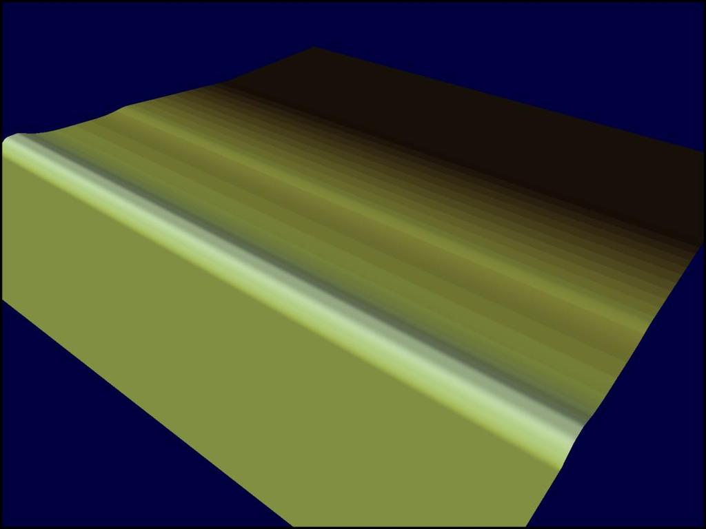
9 COADAPT WP1 model development 1. Short term erosion and breaching models 2. Long term shoreline models 3. Coastal flooding models
10 COADAPT WP1 model development 1. Short term erosion and breaching models 2. Long term shoreline models 3. Coastal flooding models
11 02. Dunes and dikes Coastal defence against flooding
12 Breaching and flooding Three processes: 1. Wave impact erosion 2. Overwash erosion 3. Breaching
13 Dune erosion MIKE21 BW further development Wave impact erosion Slumping of dune front Sediment transport
14 Overwash erosion Breaching developed as erosion on backside Phase 1: Overtopping erosion Phase 2: Overwash erosion

15 Overtopping behind bar with lower part in middle

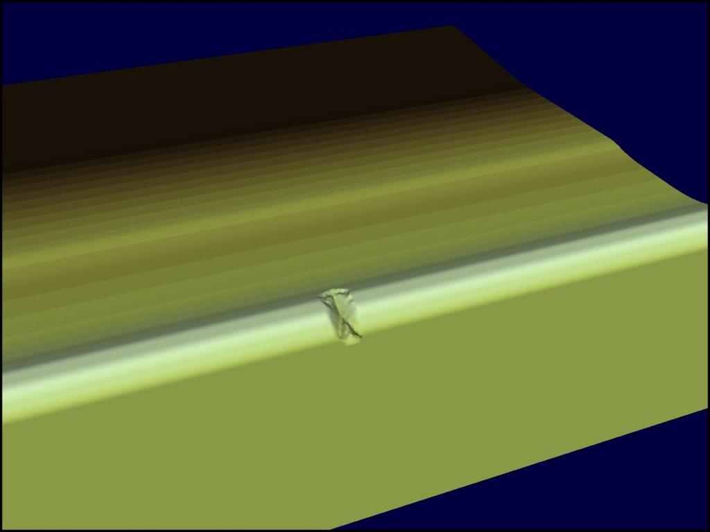
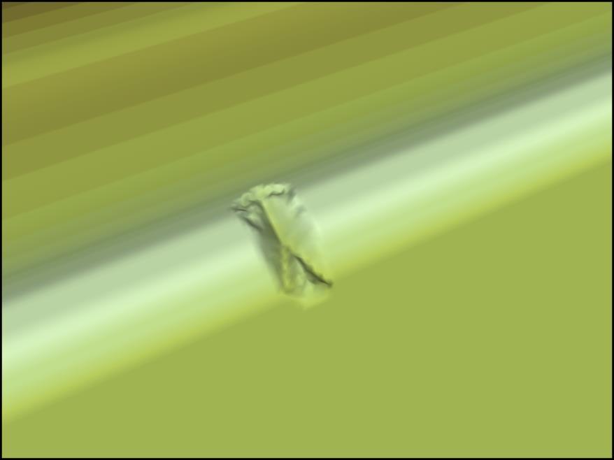
16 Dike breaching

17 Dike breaching Random distribution of weak spots how can we quantify this? What is the probalility distribution for critical shear stress?
18 Initial bathymetry

19 Dike breaching development of weak spot in dike Left: Water surface Mid: Critical shear stress Right: Dike/bed topography
20
21 Perspectives Principles for modelling erosion and breaching of dunes and dikes have been developed and tested with succes! Field and laboratory studies of strength parameters for real dikes (and dunes) has still not been developed the physical experiments lags the numerical model development, but is expected to come in the near future Models show great potential for evaluating wave impact, pulsating overtopping rates and shear stress related erosional characteristics How can dike weaknesses be parameterised? Empirical data is still missing
22 COADAPT WP1 model development 1. Short term erosion and breaching models 2. Long term shoreline models 3. Coastal flooding models
23 03. Coastal flooding Modelling hinterland flooding


24 Modelling coastal flooding Exposed coasts Sheltered coasts Static flooding modelling: Fixed level analysis Dynamic flooding modelling: MIKE 21 FM
 Opening in")


25 Breaching of dunes/dikes (exposed coasts) Opening in sea defense line Temporal development of breach prescribed Hydraulic friction formula overflow Dynamic flood model
")


26 Ribe (KDI project) Dynamic flooding aspect is essential

27 Sheltered coasts Max surface elevation Water level at Hornbæk during Bodil Dynamic aspect of local flooding not as important as the dynamic aspect of local water level
28 Perspectives Coastal flooding modelling techniques are quit mature and can be applied in many different contexts Erosion and breaching of dikes and dunes still rely on scarse data sets for model calibration and semi-empirical relationships Dynamic approach is needed A number of initiatives have been the spin off of the COADAPT flooding work, e.g. a DHI-DMI project for flood forecasting Coupling with rural and urban rain run-off will come Coupling with environmental aspects is a possibility Coupling the continous improvements in climate projections and downscaling will come
29 COADAPT WP1 model development 1. Short term erosion and breaching models 2. Long term shoreline models 3. Coastal flooding models
30 04. Long term effect Protection and sand availability
31 Modelling long term protection schemes Hard structures Soft solutions
32 Shoreline model A. A number of transects are defined B. ST flux through each transect is calculated from a 2D wave, hd, st model run C. The shoreline is adjusted according to the differences between the fluxes through each segment

33 Shoreline model 2D area 1 Line model A. A number of transects are defined B. ST flux through each transect is calculated from a 2D wave, hd, st model run C. The shoreline is adjusted according to the differences between the fluxes through each segment


34 Hard structures Shore normal breakwaters - groynes Shore parallel breakwaters


35 Shore parallel breakwaters Modelled 2D area 1-line model Salient after 4 years Survey

36 Shore parallel breakwaters Groyne fields Different groyne lengths Different alongshore spacings


37 Soft solutions: Nourishment Beach nourishment Shoreface nourishment Dune nourishment Mega nourishment


38 Mega nourishment The sand engine (The Netherlands)


39 Temporal evolution as modelled Profiles extracted from initial 2D bathymetry contour lines Aug 2011 Feb 2012 Waves from one of DHI s Northsea models Feb 2013 Dec 2013
40 Perspectives Different shoreline protection schemes can be analysed with the new model concept The model fills a gap between fully developed morphological models - difficult to apply - and simplistic shoreline models with a number of limits in the context of shoreline protection The problem of how to meet the specific regional problem can be solved with a process oriented model like this Future application: Geomorphological phenomena Skagen, long term spit formation
41 COADAPT model development 1. Short term erosion and breaching models 2. Long term shoreline models 3. Coastal flooding models
42 05. Outlook Consolidation of findings in future applications
43 Outcome of COADAPT Significant boost in modelling capacity to study coastal protection Kick starting coastal flooding modelling for the future Establish new short and long term erosion/morphological modelling techniques Modelling methodologies already applied in projects Increasing awareness of model s relevance for preparing for extreme events and long term planning Identification of most critical needs for further development Increased communication between research (KU), applied research (DHI) and application/end-user (KDI)

44 Increasing model capabilities and understanding
New modelling tools for coastal problems related to climate change
 New modelling tools for coastal problems related to climate change Nils Drønen Coastal and Estuarine Department, CED, DHI Climate change and coastal engineering Natural system Beach and dune system Coastal
BYPASS IN GROYNE FIELDS: CASE STUDY ALONG THE LOBITO SPIT
 BYPASS IN GROYNE FIELDS: CASE STUDY ALONG THE LOBITO SPIT Sten Esbjørn Kristensen 1, Nils Drønen 2, Rolf Deigaard 3, Berry Elfrink 4 Abstract The Lobito spit, in Angola, is fronted by a groyne field along
DUNE EROSION NEAR SEA WALLS: MODEL-DATA COMPARISON
 DUNE EROSION NEAR SEA WALLS: MODEL-DATA COMPARISON Pieter van Geer 1, Bram de Vries 2, Ap van Dongeren 1 and Jaap van Thiel de Vries 1,2 This paper describes the validation of the dune erosion model XBeach
SEGMENTED BREAKWATERS AND THEIR USE IN COASTAL LOUISIANA
 SEGMENTED BREAKWATERS AND THEIR USE IN COASTAL LOUISIANA Prepared by: Louisiana Coastal Protection and Restoration Authority Engineering Division March 2016 The geology of Louisiana s coastal zone is intimately
Mangrove Erosion in the Mekong delta
 Mangrove Erosion in the Mekong delta 1. Introduction a. Mangrove coast - a balance between different forcing factors Mangroves are coastal environments frequently observed in the tropical muddy coasts.
SHORELINE AND BEACH PROCESSES: PART 2. Implications for Coastal Engineering
 SHORELINE AND BEACH PROCESSES: PART 2 Implications for Coastal Engineering Objectives of the lecture: Part 2 Show examples of coastal engineering Discuss the practical difficulties of ocean engineering
Erosion and Accretion Patterns along the Danish Shores
 Department of Geosciences and Natural Resource Management rosion and Accretion Patterns along the Danish Shores Aart Kroon Danish Coasts and Climate Adaptation (COADAPT) Climate Change and Coastal Adaptation
The Marine Environment
 The Marine Environment SECTION 16.1 Shoreline Features In your textbook, read about erosional landforms, beaches, estuaries, longshore currents, and rip currents. For each statement below, write true or
Protection of Coasts
 Protection of Coasts [Coastal Zones] Jan van de Graaff Delft University of Technology 1 Coastal Zone: many definitions here: rather narrow strip of land adjacent to sea or large inland water (say: 150
Objective To enhance the management of defended coastlines through integration of coastal erosion and flood risk models
 School of Oriental and African Studies, 4 th October 2011 Practitioner workshop on asset management Shoreline evolution for flood risk assessment Dr Stuart Stripling EPSRC Grant: EP/FP202511/1 FRMRC2 WP4.3
Beach nourishment behaviour Modeling of beach nourishment planform evolution: a case study of the coast of North Zealand
 Institut for Geovidenskab og Naturforvaltning Beach nourishment behaviour Modeling of beach nourishment planform evolution: a case study of the coast of North Zealand Serena Pilunnguaq Sørensen & Sofie
MODELLING CATASTROPHIC COASTAL FLOOD RISKS AROUND THE WORLD
 MODELLING CATASTROPHIC COASTAL FLOOD RISKS AROUND THE WORLD Nicola Howe Christopher Thomas Copyright 2016 Risk Management Solutions, Inc. All Rights Reserved. June 27, 2016 1 OUTLINE MOTIVATION What we
The Marine Environment
 The Marine Environment SECTION 16.1 Shoreline Features In your textbook, read about erosional landforms, beaches, estuaries, longshore currents, and rip currents. For each statement below, write or. 1.
Aim and objectives Components of vulnerability National Coastal Vulnerability Assessment 2
 ASSESSING THE UTILITY OF GEOMORPHIC SENSITIVITY MAPPING ON THE ILLAWARRA COAST Pamela Abuodha, Christina Baker, Chris Sharples, Darren Skene and Colin Woodroffe Geoquest Research Centre, University of
AN EXPERIMENTAL STUDY ON SAND DUNE SEDIMENT TRANSPORT DUE TO TSUNAMI OVERWASH. K M Ahtesham Hossain Raju 1 and Shinji Sato 2
 AN EXPERIMENTAL STUDY ON SAND DUNE SEDIMENT TRANSPORT DUE TO TSUNAMI OVERWASH K M Ahtesham Hossain Raju 1 and Shinji Sato 2 Response of sand dune when overwashed by tsunami or storm surge, is investigated
Controlling Processes That Change Land
 1 Name Date Controlling Processes That Change Land People try to control some of the processes that change land. To do this, people apply technology- the use of science to solve problems in everyday life.
Flood Risk Mapping and Forecasting in England
 Flood Risk Mapping and Forecasting in England Mark Franklin Environment Agency, England NORDESS Workshop on Risk Assessment and Acceptable Risk Outline Flood risk in England Who we are and how we work
Weathering of Rocks. Weathering - Breakdown of rocks into pieces (sediment) 2 main types of weathering to rocks
 2 main types of weathering to rocks") Weathering of Rocks Weathering - Breakdown of rocks into pieces (sediment) 2 main types of weathering to rocks Mechanical weathering requires physical forces to break rocks into smaller pieces. Chemical
Weathering of Rocks Weathering - Breakdown of rocks into pieces (sediment) 2 main types of weathering to rocks Mechanical weathering requires physical forces to break rocks into smaller pieces. Chemical
A Detailed First Pass coastal hazard assessment for a long complex coast: Kingborough LGA, Tasmania
 A Detailed First Pass coastal hazard assessment for a long complex coast: Kingborough LGA, Tasmania Chris Sharples & Paul Donaldson University of Tasmania September 2012 Kingborough LGA, south-eastern
A Quantitative Assessment of Human Interventions and Climate Change on the West African sediment budget
 Public Disclosure Authorized Public Disclosure Authorized A Quantitative Assessment of Human Interventions and Climate Change on the West African sediment budget Public Disclosure Authorized The West African
Dunes Growth Estimation for Coastal Protection
 Dunes Growth Estimation for Coastal Protection Muhammad Zikra Department of Ocean Engineering, Faculty of Marine Technology, ITS, Kampus ITS Keputih Sukolilo, Surabaya 60111 Abstract: This paper describes
Process-based Long Term Morphological Modelling the present state-of-the-art and the way ahead. Dirk-Jan Walstra
 Process-based Long Term Morphological Modelling the present state-of-the-art and the way ahead Dirk-Jan Walstra Deltares Delft Hydraulics Delft University of Technology Les littoraux à l heure du changement
Holderness Erosion and Evolution of the Spurn Peninsula
 Holderness Erosion and Evolution of the Spurn Peninsula Prof. Ken Pye and Dr. Simon Blott Kenneth Pye Associates Ltd. Outline of the Presentation Overview of historical erosion trends Effects of coast
Coastal Processes and Shoreline Erosion on the Oregon Coast, Cascade Head to Cape Kiwanda
 State of Oregon Department of Geology and Mineral Industries Vicki S. McConnell, State Geologist Open File Report OFR O-04-11 Coastal Processes and Shoreline Erosion on the Oregon Coast, Cascade Head to
INITIAL SAND LOSSES AND LIFE SPAN PREDICTIONS FOR MEGA-NOURISHMENTS ALONG THE DUTCH COAST
 INITIAL SAND LOSSES AND LIFE SPAN PREDICTIONS FOR MEGA-NOURISHMENTS ALONG THE DUTCH COAST P.K. Tonnon 1, G.N. Stam 2, B.A. Huisman 2, 3 and L.C. van Rijn 4 In the summer of 2011 about 19 million m 3 of
12 th Polish German Seminar on Coastal Research The Baltic Sea at the middle of 21 th century
 Risk Analyis for Coastal Areas 12 th Polish German Seminar on Coastal Research The Baltic Sea at the middle of 21 th century M.Sc. Angelika Gruhn, Dipl.-Ing. Dörte Salecker, Prof. Dr.-Ing. Peter Fröhle
Protecting the Storm Damage Prevention and Flood Control Interests of Coastal Resource Areas
 Protecting the Storm Damage Prevention and Flood Control Interests of Coastal Resource Areas Presented by: Massachusetts Department of Environmental Protection & Massachusetts Office of Coastal Zone Management
WP4: COASTAL PROCESSES
 WP4: COASTAL PROCESSES Coordinator: G. EBERHARDS Faculty of Geography and Earth Sciences, University of Latvia Daugavpils, 2008 Goal: The objective of this study is analysis of coastal changes and forecast
26 Coastal erosion and accretion
 26 Coastal erosion and accretion 26.1 Rate of erosion and accretion 26.2 Length of protected coastline 26.3 Volume of sand nourishment Fig. 26.1: Coastline dynamics of the South East Baltic region Key
QU: Where does sand do jail time? AIM: To explain the sediment cell concept as a system and what human and natural factors create/upset a dynamic
 QU: Where does sand do jail time? AIM: To explain the sediment cell concept as a system and what human and natural factors create/upset a dynamic equilibrium. ST: On your copy draw and label future depositional
Coastal Sediment Transport
 Coastal & Marine Coastal Sediment Transport Mazen Abualtayef Assistant Prof., IUG, Palestine Sediment Transport Sediment is any particulate matter that can be transported by fluid flow and which eventually
The use of MIKE21 to study the. barrier beach system of Inner Dingle Bay, Co. Kerry, Ireland. Dr. Michael O Shea Malachy Walsh and Partners
 The use of MIKE21 to study the morphodynamic evolution of the mid-bay barrier beach system of Inner Dingle Bay, Co. Kerry, Ireland Dr. Michael O Shea Malachy Walsh and Partners Contents Why Study Morphodynamics
Australian Coastal Councils Conference
 Australian Coastal Councils Conference 11 March 2015 Estimating Future Coastal Inundation and Erosion Hazards Dr Andrew McCowan Dr Christine Lauchlan-Arrowsmith Warwick Bishop Background Victorian Future
New GCSE Geography AQA
 Learning Checklist Half Term 1 26 th September 3 rd October 10 th October 17 th October 1.1.1 Tectonic Hazards Plate tectonics theory. Global distribution of earthquakes and volcanic eruptions and their
MODELLING LONG-TERM COASTAL MORPHOLOGY USING EOF METHOD
 MODELLING LONG-TERM COASTAL MORPHOLOGY USING EOF METHOD Fernando Álvarez 1 and Shunqi Pan 2 Coastline is constantly changing due to the action of wind, waves, tides and sea level variations. Coastal erosion
The Erosion Problem: Perspectives. Physical
 Greg Berman The Erosion Problem: Perspectives Physical Education Regulation The Erosion Problem: Physical Perspectives What is a hotspot? Erosion Rate / Vulnerability / Frame of Reference Sandwich Town
The Coast: Beaches and Shoreline Processes
 1 2 3 4 5 6 7 8 9 The Coast: es and Shoreline Processes Trujillo & Thurman, Chapter 10 Oceanography 101 Chapter Objectives Recognize the various landforms characteristic of beaches and coastal regions.
MODELING OF EROSION CONTROL ALTERNATIVES AT STUMP PASS, CHARLOTTE COUNTY
 2014 NATIONAL CONFERENCE ON BEACH PRESERVATION TECHNOLOGY FEBRUARY 13, 2014 MODELING OF EROSION CONTROL ALTERNATIVES AT STUMP PASS, CHARLOTTE COUNTY 1 VADIM ALYMOV, PH.D. 2 CHUCK MOPPS 3 MICHAEL POFF,
HOTSPOT STATEMENT. Sainte-Marie. Languedoc-Roussillon. France. Part of the RESPONSE LIFE-Environment Project 2006
 HOTSPOT STATEMENT Hazard and risk potential, Scale of the problem, When the Part of the RESPONSE LIFE-Environment Project 2006 For more information: www.coastalwight.gov.uk /response.html Purpose of this
Mapping of Future Coastal Hazards. for Southern California. January 7th, David Revell, Ph.D. E.
 Mapping of Future Coastal Hazards for Southern California January 7th, 2014 David Revell, Ph.D. drevell@esassoc.com E. Vandebroek, 2012 Outline Coastal erosion hazard zones Flood hazard zones: Coastal
The Coast: Beaches and Shoreline Processes Trujillo & Thurman, Chapter 10
 The Coast: es and Shoreline Processes Trujillo & Thurman, Chapter 10 Oceanography 101 Chapter Objectives Recognize the various landforms characteristic of beaches and coastal regions. Identify seasonal
Dynamic Coast. Coastal erosion / Management Briefing to THC
 Dynamic Coast Coastal erosion / Management Briefing to THC What is Dynamic Coast? Dynamic Coast is a Scottish Government project, funded by CREW, managed by SNH, with a research team from the University
Geol 117 Lecture 18 Beaches & Coastlines. I. Types of Coastlines A. Definition:
 I. Types of Coastlines A. Definition: 1. Shore = narrow zone where ocean meets land (e.g. beach) 2. Coast is a broad area where both ocean and land processes act a. Includes onshore marshes, dunes, sea
Coasts Key Word Glossary
 Coasts Key Word Glossary Abrasion Also known as corrosion. It is the wearing away of the cliff by sand, fragments of rock and boulders that are being hurled at the cliff by the waves. It causes grinding
ENGINEERING WITH NATURE: NEARSHORE BERM PLACEMENTS AT FORT MYERS BEACH AND PERDIDO KEY, FLORIDA, USA
 1 ENGINEERING WITH NATURE: NEARSHORE BERM PLACEMENTS AT FORT MYERS BEACH AND PERDIDO KEY, FLORIDA, USA KATHERINE E. BRUTSCHÉ 1, PING WANG 2, JULIE D. ROSATI 1, CHERYL E. POLLOCK 1 1. U.S. Army Engineer
Strategic approach towards Post Tsunami Mitigation and Conservation of the Sri Lankan coastline
 Strategic approach towards Post Tsunami Mitigation and Conservation of the Sri Lankan coastline Dr. S.S.L.Hettiarachchi Dr. S.P.Samarawickrama University of Moratuwa Illustrated via a Case Study for the
STORM IMPACT MODELING ANALYSIS FOR THE RESTORATION OF GULF STATE PARK, AL
 STORM IMPACT MODELING ANALYSIS FOR THE RESTORATION OF GULF STATE PARK, AL Jordon Cheifet, PE, CFM Joao Dobrochinski, MSc Morjana Signorin APTIM Senior Project Engineer APTIM Numerical Modeling Lead APTIM
RISC-KIT: EWS-DSS Hotspot Tool
 RISC-KIT: EWS-DSS Hotspot Tool Robert McCall Ap van Dongeren Deltares www.risckit.eu This project has received funding from the European Union s Seventh Programme for Research, Technological Development
Coastal Evolution in Sedimentary Areas in Greenland
 Coastal Evolution in Sedimentary Areas in Greenland Mette Bendixen P h D s t u d e n t DANCORE Young Professionals Day Dias 1 Outline Motivation State of the art on Arctic coasts Purpose of my Phd Presentation
CHANGES IN BEACH SURFACE SEDIMENT COMPOSITION
 CHANGES IN BEACH SURFACE SEDIMENT COMPOSITION Compiled by Tamsin Watt. Edited by Rendel Williams and Cherith Moses 1 Aims...2 2 Introduction...2 3 Sites...2 4 Survey methodology...2 5 Analysis procedure...3
Evaluation of nourishment strategies Holland Coast HK4.1: Long-term sustainable strategies for the Holland Coast Cycle 1
 Evaluation of nourishment strategies Holland Coast HK4.1: Long-term sustainable strategies for the Holland Coast Cycle 1 Bas Huisman Arjen Luijendijk Deltares, 2010 Content 1 Introduction 1 1.1 Introduction
Climate Change and Gravel-Beach Responses: Hawke s Bay, New Zealand
 Conference Proceedings, 2015 Solutions of Coastal Disasters, Boston, MA COPRI, American Society of Civil Engineers Climate Change and Gravel-Beach Responses: Hawke s Bay, New Zealand Paul D. Komar 1 and
The probabilistic optimisation of the revetment on the dikes along the Frisian coast
 The probabilistic optimisation of the revetment on the dikes along the Frisian coast M. Hussaarts, J.K. Vrijling, P.H.A.J.M. van Gelder Subfaculty of Civil Engineering, Delft University of Technology,
Proposal for Research and Investment Activities in the Coast and Estuaries (A Case Study in the North Central Coast of Viet Nam)
") 2017/SOM3/EPWG/019 Agenda Item: 7.2.3 Proposal for Research and Investment Activities in the Coast and Estuaries (A Case Study in the North Central Coast of Viet Nam) Purpose: Information Submitted by:
2017/SOM3/EPWG/019 Agenda Item: 7.2.3 Proposal for Research and Investment Activities in the Coast and Estuaries (A Case Study in the North Central Coast of Viet Nam) Purpose: Information Submitted by:
TECHNIQUES FOR ASSESSING COASTAL HAZARD AREAS FOR THE GISBORNE DISTRICT COAST
 TECHNIQUES FOR ASSESSING COASTAL HAZARD AREAS FOR THE GISBORNE DISTRICT COAST July 1994 C.R. 1994/12 Jeremy G Gibb 2009 All rights reserved. This work is entitled to the full protection given by the Copyright
Beach Recovery Processes in Urban Beach Systems : A Study in Hong Kong after an Extreme Storm Event
 Beach Recovery Processes in Urban Beach Systems : A Study in Hong Kong after an Extreme Storm Event LIFE+ FLANDRE international workshop "Management of coastal dunes and sandy beaches" Session 1. Climate
The "Geo-Information System Coast Mecklenburg-Vorpommern"
 The "Geo-Information System Coast Mecklenburg-Vorpommern" Lars Tiepolt State Office for Environment and Nature Rostock, Germany Abstract The Division Coast of the State Office for Environment and Nature
Hurricanes and Storm Surge : Before coming to lab, visit the following web site:
 Geol 108 Lab #7 Week of October 15-19, 2012 Coastal Studies Hurricanes and Storm Surge : Before coming to lab, visit the following web site: http://www.usatoday.com/graphics/weather/gra/gsurge/flash.htm
Term Knowledge Using and applying Grade Criteria Autumn 1 Assessment window October Natural hazards pose major risks to people and property.
 Assessment Schedule Year 9 2015/6 Term Knowledge Using and applying Grade Criteria Autumn 1 Assessment window October 2015 3.1.1.2 Tectonic Natural hazards pose major risks to people and property. Definition
Soil erosion susceptibility and coastal evolution: examples in southern New Caledonia
 Pacific Island Countries GIS /RS User Conference Soil erosion susceptibility and coastal evolution: examples in southern New Caledonia Pascal DUMAS et Olivier COHEN University of New-Caledonia (EA 4242/
A Generic Coastal Erosion Hazard Zoning for Tasmania. Chris Sharples, Hannah Walford & Luke Roberts April 2014
 A Generic Coastal Erosion Hazard Zoning for Tasmania Chris Sharples, Hannah Walford & Luke Roberts April 2014 Why do we need comprehensive coastal erosion hazard zones for Tasmania? Roches Beach 2011 Why
Scenarios for the NI coast in the 21 st Century
 Scenarios for the NI coast in the 21 st Century Prof Julian Orford Geography, Archaeology & Palaeoecology Queen s University, Belfast Challenging perspective Living by the coast is good for your health!
Annual transport rates at two locations on the fore-slope.
 Sediment Transport by Currents Fore-slope Sediment transport rates and sediment concentrations were computed from the hydrodynamic model runs as well as from direct measurements of current velocities at
Sea level rise and coastal morphological changes on tropical islands New Caledonia and French Polynesia (South Pacific)
") Manuel Garcin, Marissa Yates, Goneri Le Cozannet, Patrice Walker, Vincent Donato Sea level rise and coastal morphological changes on tropical islands New Caledonia and French Polynesia (South Pacific)
Manuel Garcin, Marissa Yates, Goneri Le Cozannet, Patrice Walker, Vincent Donato Sea level rise and coastal morphological changes on tropical islands New Caledonia and French Polynesia (South Pacific)
XBeach modeling at various temporal and spatial scales
 //oss.deltares.nl/web/xbeach XBeach modeling at various temporal and spatial scales Ad Reniers, RSMAS, UM : Impact of time and process scales XBeach modeling concepts avalanching dune Wave groups c g Bound
USING MIKE TO MODEL COASTAL CATASTROPHE RISK
 USING MIKE TO MODEL COASTAL CATASTROPHE RISK Nicola Howe, Christopher Thomas, Joss Matthewman, John Maskell* 1 SUMMARY About RMS Who are we and what do we do? How do we use MIKE in our workflow? Case study:
Influence of extreme events on sedimentation in sedimentation fields enclosed by brushwood fences
 Influence of extreme events on sedimentation in sedimentation fields enclosed by brushwood fences A. Matheja Franzius-Institute for Hydraulic, Waterways and Coastal Engineering, University of Hannover,
Coastal Erosion Risks - Beaches. Objectives
 Coastal Erosion Risks - Beaches Risk Management in Civil Engineering, Advanced Course Lisbon, November 21 st, 2008 Objectives To briefly introduce coastal processes governing sediment transport and beach
GenCade. Combining and Extending the GENESIS and Cascade Models for Planning and Design in a Regional Sediment Management Framework
 GenCade Combining and Extending the GENESIS and Cascade Models for Planning and Design in a Regional Sediment Management Framework G Presented by Nicholas C. Kraus For the GenCade Development Team Ken
SCIENCE & TECHNOLOGY
 Pertanika J. Sci. & Technol. 25 (3): 1009-1018 (2017) SCIENCE & TECHNOLOGY Journal homepage: http://www.pertanika.upm.edu.my/ Estimation and Validation of Nearshore Current at the Coast of Carey Island,
Physical landscapes River landscapes in the UK
 Physical landscapes River landscapes in the UK The shape of river valleys change s as rivers flow downstream - PROCESSES Erosion Abrasion or corrasion Attrition Hydraulic Action Solution or corrosion Deposition
Coastal Landscapes Case Study 3 days
 GCSE Geography OCR A Coastal Landscapes Case Study 3 days In-depth study of a coastal landscape providing a detailed case study, to ensure students are prepared for the Paper 1 exam: Living in the UK Today.
Coastal Landscapes Case Study 3 days
 GCSE Geography OCR B Coastal Landscapes Case Study 3 days In-depth study of a coastal landscape providing a detailed case study, to ensure students are prepared for Paper 1: Our Natural World. Complete
Issue to be addressed
 Climate change impacts in fluvial, coastal and transition zones in Mediterranean environments altered by human activities: Guadalfeo and Adra river mouths Andrea Lira Loarca - aliraloarca@ugr.es Manuel
Map Introduction: South Uist Map 6
 6 Map Introduction: Map 6 This map section covers part of the west coast of. It extends from Cill Donnain to Ardvule and onwards to Ormacleit. There is no modern settlement within the coastal zone but
Linking Inlet Hydrodynamics and Morphologic Response at Oregon Inlet, NC
 Linking Inlet Hydrodynamics and Morphologic Response at Oregon Inlet, NC Prepared for: Sharon Ahlers Engineering Communications Program Cornell University Prepared by: Justin Vandever School of Civil and
Development and application of demonstration MIKE 21C morphological model for a bend in Mekong River
 Development and application of demonstration MIKE 21C morphological model for a bend in Mekong River September 2015 0 Table of Contents 1. Introduction... 2 2. Data collection... 3 2.1 Additional data...
ISPRA. Stefano Bataloni ISPRA
 MINISTRY FOR THE ENVIRONMENT AND LAND AND SEA PROTECTION Istituto Superiore per la Protezione e la Ricerca Ambientale National Institute for Environmental Protection and Research THE ITALIAN NATIONAL BOARD
Erosion along the Holderness Coast
 PT-2013: Coastal and Ocean Engineering ENGI.8751 Undergraduate Student Forum Faculty of Engineering and Applied Science, Memorial University, St. John s, NL, Canada March, 2013 Paper Code. (PT-2013 - Carson)
La fascia costiera emiliano-romagnola: dinamiche e criticità The coastline of Emilia-Romagna: dynamic and hazards Luisa Perini
 La fascia costiera emiliano-romagnola: dinamiche e criticità The coastline of Emilia-Romagna: dynamic and hazards Luisa Perini IMPORTANCE OF THE COASTAL ZONE strategic importance of coastal zone & conflicts
COASTAL FLOODING RISK CALCULATIONS FOR THE BELGIAN COAST
 COASTAL FLOODING RISK CALCULATIONS FOR THE BELGIAN COAST Verwaest, T. 1, Van der Biest, K. 1, Vanpouce, P. 2, Reyns, J. 2, Vanderimpen, P. 3, De Vos, L. 2, De Rouc, J. 2, Mertens, T. 4 This paper details
INFLUENCE OF INLET / SHOAL COMPLEX ON ADJACENT SHORELINES VIA INLET SINK METHOD
 INFLUENCE OF INLET / SHOAL COMPLEX ON ADJACENT SHORELINES VIA INLET SINK METHOD Kelly R. Legault, Ph.D., P.E. 1, Tanya M. Beck 2 and Jason A. Engle, P.E. 3 The region of influence of the inlet on the adjacent
Summary Visualizations for Coastal Spatial Temporal Dynamics
 Summary Visualizations for Coastal Spatial Temporal Dynamics October 24 2011 Providence, RI Sidharth Thakur 1, Laura Tateosian 2, Helena Mitasova, Eric Hardin, and Margery Overton 1. sthakur@renci.org,
ON THE EVOLUTION OF A HOLOCENE BARRIER COAST
 ON THE EVOLUTION OF A HOLOCENE BARRIER COAST Response to sea-level change and sediment supply DANCORE Seminar 2014 COADAPT - Danish Coasts and Climate Adaptation Flooding Risk and Coastal Protection Mikkel
INFLUENCE OF A INFRASTRUCTURE ON TSUNAMI INUNDATION IN A COASTAL CITY: LABORATORY EXPERIMENT AND NUMERICAL SIMULATION
 INFLUENCE OF A INFRASTRUCTURE ON TSUNAMI INUNDATION IN A COASTAL CITY: LABORATORY EXPERIMENT AND NUMERICAL SIMULATION Sungwon Shin 1, Kwang-Ho Lee 1, Hyungsu Park 2, Daniel T. Cox 2, Kyuhan Kim 1 Laboratory
Supplemental Slides. Shore: Junction of Land & Water. Junction of Land & Water. Sea Level Variations. Shore vs. Coast. Sea Level Variations
 Shore: Junction of Land & Water Supplemental Slides Sediments come off land Most get dumped at the beach Sediment interacts with ocean waves and currents Junction of Land & Water Features: Breaking waves,
Shore: Junction of Land & Water. Sediments come off land Most get dumped at the beach Sediment interacts with ocean waves and currents
 Shore: Junction of Land & Water Supplemental Slides Sediments come off land Most get dumped at the beach Sediment interacts with ocean waves and currents Junction of Land & Water Features: Breaking waves,
GLY Coastal Geomorphology Notes
 GLY 4734 - Coastal Geomorphology Notes Dr. Peter N. Adams Spring 2011 2 Coastal Classification In this lecture, we discuss some successful classification schemes of the coastal landscape, and pay particular
Coastline monitoring. Virginie Lafon Cyril Mallet. S. Capo, A. Dehouck, E. Maneux, A. Michot, C. Proisy, R. Walker
 Coastline monitoring Virginie Lafon Cyril Mallet Doris_Net May 29, 2012 Pessac, France S. Capo, A. Dehouck, E. Maneux, A. Michot, C. Proisy, R. Walker 29/05/2012 Spatial applications for coastal services
A probabilistic storm surge risk model for the German North and Baltic Sea coast
 A probabilistic storm surge risk model for the German North and Baltic Sea coast Jan-Henrik Grabbert 1), Jan Deepen 2), Andreas Reiner 2), Stephan Mai 3), Harvey Rodda 4), Dietmar Pfeifer 5) and Andreas
Climate Change Impacts and Adaptation for Coastal Transport Infrastructure in Caribbean SIDS
 UNCTAD National Workshop Saint Lucia 24 26 May 2017, Rodney Bay, Saint Lucia Climate Change Impacts and Adaptation for Coastal Transport Infrastructure in Caribbean SIDS LISCoAsT Large Scale Integrated
Lagos Shoreline Change Pattern:
 American-Eurasian Journal of Scientific Research 1 (1): 25-30, 2006 ISSN 1818-6785 IDOSI Publications, 2006 Lagos Shoreline Change Pattern: 1986-2002 1 2 Okude Adeyinka Sunday and Taiwo Olalekan John 1
GCSE 4242/02 GEOGRAPHY (Specification B) FOUNDATION TIER UNIT 2 SECTION B
 FOUNDATION TIER UNIT 2 SECTION B") Surname Centre Number Candidate Number Other Names 0 GCSE 4242/02 GEOGRAPHY (Specification B) FOUNDATION TIER UNIT 2 SECTION B S15-4242-02 P.M. WEDNESDAY, 3 June 2015 1 hour 30 minutes For s use Part Maximum
Surname Centre Number Candidate Number Other Names 0 GCSE 4242/02 GEOGRAPHY (Specification B) FOUNDATION TIER UNIT 2 SECTION B S15-4242-02 P.M. WEDNESDAY, 3 June 2015 1 hour 30 minutes For s use Part Maximum
Texas A & M University and U.S. Bureau of Reclamation Hydrologic Modeling Inventory Model Description Form
 Texas A & M University and U.S. Bureau of Reclamation Hydrologic Modeling Inventory Model Description Form JUNE, 1999 Name of Model: Two-Dimensional Alluvial River and Floodplain Model (MIKE21 CHD & CST)
Landscape Systems: Coasts 3 days
 AS Level Geography Edexcel Landscape Systems: Coasts 3 days Deliver two days of fieldwork within an inspiring physical environment covering all the recommended themes in depth. Prepare AS level students
Lab 12 Coastal Geology
 Lab 12 Coastal Geology I. Fluvial Systems Hydrologic Cycle Runoff that flows into rivers = precipitation (rain and snowmelt) [infiltration (loss to groundwater) + evaporation (loss to atmosphere) + transpiration
Hurricane Harvey: Texas Coastal Erosion Hot Spot Analysis
 Hurricane Harvey: Texas Coastal Erosion Hot Spot Analysis Texas ASBPA Symposium April 24, 2018 Alan Johnson, FEMA Chris Levitz, Compass Agenda Introduction Hurricane Harvey Erosion Hot Spot Analysis Purpose
A methodology for impact, vulnerability and adaptation assessment in the coastal zone
 UNFCCC expert meeting on methods and tools and on data and observations under the Nairobi work programme on impacts, vulnerability and adaptation to climate change Mexico City, Mexico, 4-7 March 2008 A
Coastal and Hydraulics Laboratory
 ERDC/CHL TR-12-16 Great Lakes Coastal Flood Study, 2012 Federal Inter-Agency Initiative Lake Michigan: Prediction of Sand Beach and Dune Erosion for Flood Hazard Assessment Bradley D. Johnson August 2012
THC-T-2013 Conference & Exhibition
 Modeling of Shutter Coastal Protection against Storm Surge for Galveston Bay C. Vipulanandan, Ph.D., P.E., Y. Jeannot Ahossin Guezo and and B. Basirat Texas Hurricane Center for Innovative Technology (THC-IT)