Proposal for Research and Investment Activities in the Coast and Estuaries (A Case Study in the North Central Coast of Viet Nam)
|
|
|
- Josephine Bailey
- 5 years ago
- Views:
Transcription


1 2017/SOM3/EPWG/019 Agenda Item: Proposal for Research and Investment Activities in the Coast and Estuaries (A Case Study in the North Central Coast of Viet Nam) Purpose: Information Submitted by: Viet Nam 12 th Emergency Preparedness Working Group Meeting Ho Chi Minh City, Viet Nam August 2017

2 PROPOSE RESEARCH AND INVESTMENT ACTIVITIES FOR VIETNAM COAST Case study on change of coast and estuaries in North Central Coast of Vietnam Viet Nam Academy for Water Resources
3 CONTENT - Introduction of natural conditions & erosion, sedimentation in the North Central Coast - Activities have been undertaken to prevent the North Central Coast + Researches and measures have been applied + Current status of erosion, sedimentation management + Technical solutions and measures have been applied + Some limitations of activities. - Propose cooperation to support research and management of erosion and sedimentation


.")
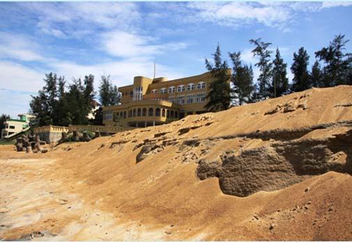
4 1. Introduction of natural conditions & erosion, sedimentation It has 817 km coastline, including 8 coastal provinces: Thanh Hoa, Nghe An, Ha Tinh, Quang Binh, Quang Tri, Thua Thien-Hue, Da Nang, Quang Nam. Population is concentrated in coastal areas. Terrain: The West is the Truong Son mountain range, to the East is narrow coastal plain area, with many high coastal sand dunes. Separated by many many short and steep rivers directly into the sea. On average, every 20 to 25 km of coastline has an estuary. Erosion, sedimentation has a serious and direct impacts on people's life and socio-economic because population is concentrated in coastal areas (urban cities locate near coast, tourism ). There are little investment on disaster prevention compared to other regions Biển Thiên Cầm-Hà Tĩnh Biển Lăng Cô TT.Huế Biển Đà Nẵng Vị trí địa lý KV Bắc Trung Bộ


.")
5 1. Introduction of natural conditions & erosion, sedimentation Các cơn bão ảnh hưởng đến Bắc Trung Bộ During a year, the Northeast monsoon from October to February of the following year; the Southwest monsoon from May to August. Rain fall concentrated in the short time make flood causes large erosion of rivers bank and estuary. Is the region with Typhoons and tropical cyclones landfall most of Viet Nam. During the period , there were 126 typhoons (57% of typhoons landfall in Viet Nam), many strong typhoons from level 9 (80 km/h) to level 13 (133 km/h). Typhoons and tropical cyclones cause heavy rain fall and flood, storm surge, high waves make coastal erosion and destroy of coastal constructions. Tide is complex, including diurnal tide and semi-diurnal tide mixed, amplitude from m. Tidal current changes in both direction and magnitude by season and by location.

, Hoi An (Q.Nam); Quang Cu (T.Hoa), Cua Tung beach (Q.Tri), Quang Cong, Thuan An (T.T.Hue).")
6 1. Introduction of natural conditions & erosion, sedimentation The North Central Coast region has the highest rate of erosion/sedimentation in estuaries and coastlines in Viet Nam. Erosion and sedimentation have worsened due to the impact of upstream exploitation of of river basins and climate change. Statistics erosion/sedimentation of estuaries, coasts: - To 2017, there are 35 sites of severely eroded coastline, corresponding to 30.5 km; Some of erosion hotspots such as Nhat Le, Bao Ninh (Q. Binh), Hoi An (Q.Nam); Quang Cu (T.Hoa), Cua Tung beach (Q.Tri), Quang Cong, Thuan An (T.T.Hue). No Region Total eroded sites Severely eroded sites - Sedimentation: estuaries have been sedimentation in recent years such Viet Nam as Sot (Ha Tinh), Tung and Viet (Quang Tri), and Tu Hien (T.T.Hue). 1 The North region The Center region The South region Total length of the eroded coastline about 310 km


")


7 Some of erosion hotspots Quang Cong Hoi An (Quang Nam) Eroded continuously each year Thuan An Phu Thuan North of Nhat Le river mouth (Quang Binh) South of Nhat Le river mouth (Quang Binh) About 200 m of coastline is eroded (Cua Tung beach)


 Tu")
 A fishing")

8 Some of sedimentation hotspots Deposition at the Cua Tung bridge (about 2/3 of cross section) Tu Hien (Thu Thien Hue) A fishing boat ran aground Nhat Le mouth (Quang Binh) Sot mouth (Ha Tinh)
9 2. Activities have been undertaken to control coastal erosion and sedimentation 2.1 Some case studies and research methods 1. Research on erosion and countermeasures for Hoi An coast ( ), sponsored by AFD (France): Understanding the erosion/sedimentation mechanism in Cua Dai estuary; Proposed measures for coastal protection against erosion and beach restoration. 2. Other researchs on estuary training (anti-sedimentation, shore stabilization and beach restoration) from 2010 to 2014: Ma river estuary (Thanh Hoa); Nhat Le estuary (Quang Binh); Ben Hai river mouth (Quang Tri); Huong River estuary (Hue) Planning and Implementation of the Sea Dike Systems from Quang Ninh to Quang Nam ( ) with consideration of climate change and combining coastal traffic: Evaluating the erosion status, coastal protection measures, identifying sea dikes (alignment, cross section, elevation ). 4. The Science and Technology Program for Sea Dike construction in cooperation with the Netherlands ( ): Determine wave height, cross section for sea dikes; Determine location to build dike in the area of no dike existing and adjust locations of existing dike systems; Management and protection of coastal sand dunes; Issue "Sea Dike Design Guideline...


10 Field survey: - In some years prior to 2007: periodical measurements of topography, meteorological and hydrological factors in some coastal zones, estuaries. - In the period from 2008 to 2010: surveyed and mapped coastal topography scale 1 : for the entire coastal zone of Vietnam. - From 2010: measurements of topography, meteorological and hydrological factors in some coastal zones, estuaries (non-periodic). 2. Activities have been undertaken to control coastal erosion and sedimentation 2.1 Some case studies and research methods

11 2. Activities have been undertaken to control coastal erosion and sedimentation 2.1 Some case studies and research methods Using Remote Sensing Technology in monitoring and evaluation of coastal and estuarine changes. Using numerical models in forecasting: - Study of coastal evolution on horizontal platform: MIKE-Denmark: (modules: MIKE21 SW, HD, ST, COUPELE; LITPACK; CEDAS- USA (RCPWVE, STWWAVE, GENESIS, SMS) - Study of coastal evolution on vertical platform: CEDAS - USA (SBEACH), DUROS - Plus Netherlands...


12 2. Activities have been undertaken to control coastal erosion and sedimentation 2.1 Some case studies and research methods Researching on wave flume, wave and tide basin for measures Wave flume, wave and tide basin in Viet Nam Academy for Water Resources
; Dyke Law (79/2006/QH11); National Strategy on Natural Disaster Prevention and Mitigation (172/QĐ- TTg);")
13 2. Activities have been undertaken to control coastal erosion and sedimentation 2.2 Coastal Disaster Management * Legal documents: Disaster Preparedness Law (33/2013/QH13); Dyke Law (79/2006/QH11); National Strategy on Natural Disaster Prevention and Mitigation (172/QĐ- TTg); Regulations on treatment of riverbank and coastline erosion (01/2011/QD-TTg). Organizational structure, management apparatus: Fundamentally completed from Government to local levels (Central Steering Committee for Disaster Prevention and Control, General Department of Disaster Prevention, etc.) Database and technology for management: - Web sites (operating, directing); - Database of erosion management (using GIS, remote sensing); - Automatic monitoring system (meteorological factors, coastline...).
14 2. Activities have been undertaken to control coastal erosion and sedimentation 2.3 Technical solutions and measures applied Protection works, works against coastaline and beach erosion: - There are 821 km sea dikes and river mouth dykes built, with over 300 km protected by revetment systems. - Solution works: revetment, sea wall, groin, revetment reduce wave with a variety of textures and materials. + Solution on materials: natural materials; Stone; Poured concrete, geotextile. + Solution of structural components: Concrete Block; Articulating Concrete Block Revetment System; composite slopes and berms revetment; Cement pipe...


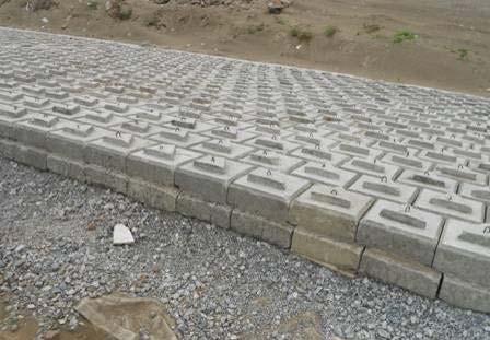
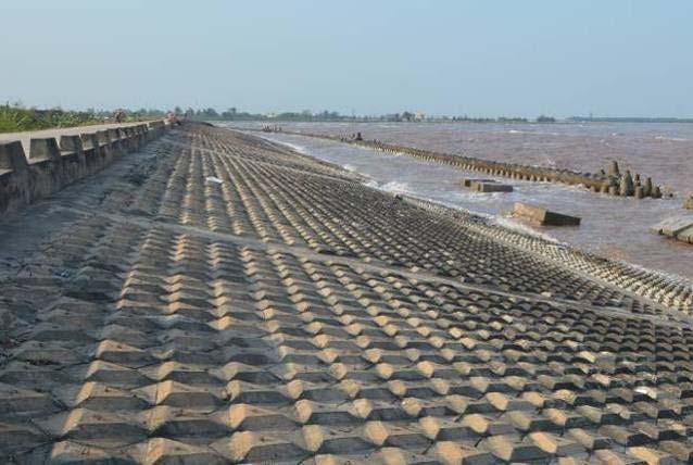
15 Some of the solutions have been implemented Revetment for coastal protection rip-rap revetment with frame Stepped concrete block revetment Articulating Concrete Block System

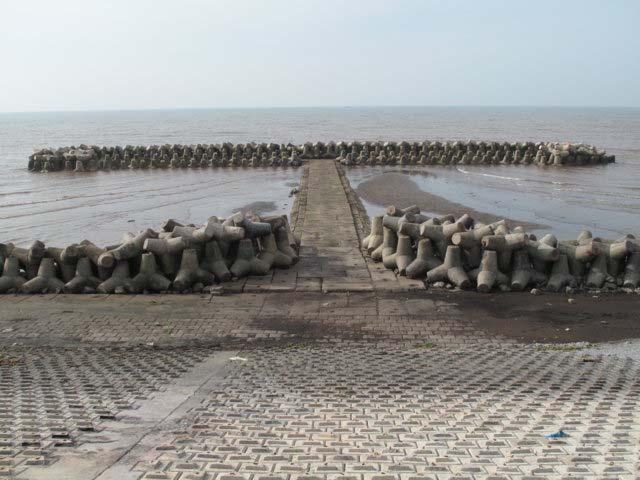


16 Groynes for coastal protection Tetrapod Toe protection of revetment Cement-pipe groyne Protect revetment s toe by Cement-pipe Prestressed concrete piles


17 Other types of structure Groyne with stabiplage techniques Stabiplage Mangrove planting


18 Estuary training works: - The main task is to prevent sand trapping and reduce waves, to safe for boats and coastal economic activities; - Measures: groynes with various types of materials and structures. Viet mouth (Quang Tri) Thuan An mouth (TT.Hue) Tung mouth (Quang Tri)
19 2. Activities have been undertaken to control coastal erosion and sedimentation 2.4 Some limitations of activities * Limitations on research: - The data of Coast and estuary has not been centrally managed and updated regularly. - Field survey equipment for research are incomplete, some are old and outdated that do not meet the requirements. - Results of the research study has limited scientific basis and not quantified in detail, as quantitative evaluation of key factors to clarify the mechanism, causes of coastal erosion, sedimentation in estuary. - Advanced technologies (GIS, remote sensing) have not been widely used in the management of the coastal zone of Vietnam as well as the North Central Coast. - Research on beach restoration and rehabilitation technologies has not seen much progress. - The research experts in the field of morphology, works are lack and not well organized.


20 2. Activities have been undertaken to control coastal erosion and sedimentation 2.4 Some limitations * Limitations on construction Construction design: not suitable. - Groins: There still has mistakes in designing of space allocation of groins system, detached breakwater Cement pipes at toe of revetment were broken by erosion - Revetment: Design parameters of revetment has not been suitable for both patterns: berm, slide roof, toe rip-rap revetment with frame was broken by wave


21 2. Activities have been undertaken to control coastal erosion and sedimentation 2.4 Some limitations * Limitations on construction: Construction works - Roof reinforcement: Concrete blocks are produced in the construction site so it is difficult to control the quality; - Toe reinforcement: space between components of revetment s toe is not suitable. construction of revetment on unstable ground Construction maintenance: - The monitoring, evaluation, management and maintenance of the works after construction is not proper, small damage untreated will lead to the instability of the whole works. Concrete blocks are produced with low quality


 before Before Cua Dai beach (Hoi An -")
22 3. Propose cooperation to support erosion, sedimentation research and management 3.1 Propose cooperation to support on research Research on technical solutions and technology of beach restoration Cua Tung beach ( Quang Tri) before Before Cua Dai beach (Hoi An - Quang Nam) present present


23 3.2 Propose cooperation to support a case study Research for Estuary Training of Ben Hai river, Quang Tri province the North Central Coast of Viet Nam Eroded beach at the North of river mouth Current status of Ben Hai river mouth Deposition in river mouth Jetty at the South of river mouth


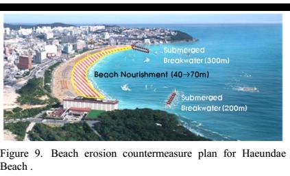

24 Haeundae beach- Busan, Korea ( 2016)


25 Thank you for attention!
Vietnam Coastal Erosion - Cause and Challenges -
 Administration of Sea and Islands Center for Oceanography University of Transport and Communications, Hanoi Vietnam Vietnam Coastal Erosion - Cause and Challenges - Presenters: Pham Hoang KIEN Le Van CONG
Current Status of Vietnam Coastal Erosion and Major Measures for Mitigation
 Vietnam Administration of Sea and Islands Center for Oceanography University of Transport and Communications Current Status of Vietnam Coastal Erosion and Major Measures for Mitigation Case Study: Thanh
HEAVY RAIN OVER MID-CENTRAL REGION OF VIETNAM
 HEAVY RAIN OVER MID-CENTRAL REGION OF VIETNAM ----------------------------------------------------------------------- S.Eng. Dang Thi Mai; Dr. Nguyen Thi Tan Thanh National Hydro Meteorological Service
Recent development of the National Hydro-Meteorological Service (NHMS) of Viet Nam for disaster risk reduction
 of Viet Nam for disaster risk reduction") Ministry of Natural Resources and Environment National Hydro-Meteorological Service Recent development of the National Hydro-Meteorological Service (NHMS) of Viet Nam for disaster risk reduction Tran Van
Ministry of Natural Resources and Environment National Hydro-Meteorological Service Recent development of the National Hydro-Meteorological Service (NHMS) of Viet Nam for disaster risk reduction Tran Van
Investigation, assessment and warning zonation for landslides in the mountainous regions of Vietnam
 Investigation, assessment and warning zonation for landslides in the mountainous regions of Vietnam (State-Funded Landslide Project SFLP) Dr. Eng. Le Quoc Hung Add: 67 Chien Thang Street, Ha Dong District,
E2993 v4. Background on Natural Disaster. Environmental Assessment (EA) Viet Nam Managing Natural Hazards Project (VN-Haz/WB5) ANNEX 4
 Viet Nam Managing Natural Hazards Project (VN-Haz/WB5) ANNEX 4") Public Disclosure Authorized Public Disclosure Authorized Public Disclosure Authorized Public Disclosure Authorized Environmental Assessment (EA) ANNEX 4 Background on Natural Disaster 1. This annex presents
Public Disclosure Authorized Public Disclosure Authorized Public Disclosure Authorized Public Disclosure Authorized Environmental Assessment (EA) ANNEX 4 Background on Natural Disaster 1. This annex presents
J-river engineering for Vietnam
 J-river engineering for Vietnam Workshop on erosion control in the Mekong Delta Soc Trang, June 2015 Onga river, Japan Dr. MATSUKI Trung: JICA Expert 1 Project for Building Disaster Resilient Society in
CLIMATE CHANGE IN VIET NAM: Observed and Future Projection
 2017 ACTS Workshop on Extreme Weather Forecast and Water Resources Management CLIMATE CHANGE IN VIET NAM: Observed and Future Projection Mai Van KHIEM Viet Nam Institute of Meteorology, Hydrology and Climate
RISK OF TYPHOON AND STORM SURGES IN COASTAL AREAS OF VIETNAM
 RISK OF TYPHOON AND STORM SURGES IN COASTAL AREAS OF VIETNAM Hoang Duc Cuong, Nguyen Ba Thuy, Nguyen Van Huong, Du Duc Tien Vietnam National Center for Hydro-meteorological Forecasting (NCHMF) Hanoi, 26-27
Using Reanalysis SST Data for Establishing Extreme Drought and Rainfall Predicting Schemes in the Southern Central Vietnam
 Using Reanalysis SST Data for Establishing Extreme Drought and Rainfall Predicting Schemes in the Southern Central Vietnam Dr. Nguyen Duc Hau 1, Dr. Nguyen Thi Minh Phuong 2 National Center For Hydrometeorological
Huong River. Serial No. : Viet Nam-8 Location: Thua Thien Hue Province, Viet Nam N 16 00' '
 Viet Nam 8 Huong River Map of River Table of Basic Data Name: Huong River Serial No. : Viet Nam-8 Location: Thua Thien Hue Province, Viet Nam N 16 00' - 14 40' E 107 07' - 107 50' 2 Area: 2,830 km Length
2014 Summer training course for slope land disaster reduction Taipei, Taiwan, Aug
 MINISTRY OF SCIENCE AND TECHNOLOGY HYDROTECH RESEARCH INSTITUTE MINISTRY OF NATURAL RESOURCES AND ENVIRONMENT VIETNAM INSTITUTE OF GEOSCIENCES AND MINERAL RESOURCES (VIGMR) 2014 Summer training course
CHAPTER 6 CLIMATE AND CLIMATE - RELATED DISASTER PROFILE OF HA TINH
 CHAPTER 6 CLIMATE AND CLIMATE - RELATED DISASTER PROFILE OF HA TINH 6.1. Introduction This Chapter provides background climatic data for Ha Tinh, as a prelude to the climate change scenarios and vulnerability
THE MODEL OF SPATIAL ORGANIZATION OF COASTAL FISHERMEN VILLAGES IN THE SOUTH CENTRAL COAST OF VIETNAM
 i MINISTRY OF EDUCATION AND TRAINING MINISTRY OF CONSTRUCTION HANOI ARCHITECTURAL UNIVERSITY TRAN VAN HIEN THE MODEL OF SPATIAL ORGANIZATION OF COASTAL FISHERMEN VILLAGES IN THE SOUTH CENTRAL COAST OF
Hydraulic modelling for flood vulnerability assessment, case study in river basins in North Central Vietnam
 Hydraulic modelling for flood vulnerability assessment, case study in river basins in North Central Vietnam Tran Ngoc Anh 1*,2, Dang Dinh Kha 1,2, Dang Dinh Duc 2, Nguyen Thanh Son 1 1 Faculty of Hydrology
Controlling Processes That Change Land
 1 Name Date Controlling Processes That Change Land People try to control some of the processes that change land. To do this, people apply technology- the use of science to solve problems in everyday life.
ME KONG RIVER COMMISSION FLASH FLOOD GUIDANCE SYSTEM (MRCFFGS)
") NATIONAL HYDRO-METEOROLOGICAL SERVICE IN VIETNAM NATIONAL CENTER FOR HYDRO-METEOROLOGICAL FORECASTING ME KONG RIVER COMMISSION FLASH FLOOD GUIDANCE SYSTEM (MRCFFGS) http://www.nchmf.gov.vn 29 Nov 1 Dec
NATIONAL HYDRO-METEOROLOGICAL SERVICE IN VIETNAM NATIONAL CENTER FOR HYDRO-METEOROLOGICAL FORECASTING ME KONG RIVER COMMISSION FLASH FLOOD GUIDANCE SYSTEM (MRCFFGS) http://www.nchmf.gov.vn 29 Nov 1 Dec
Populations effected by flood top ten districts
 2050 - Populations effected by flood top ten districts 14 Extreme A2 Extreme A2 with dyke District Area (Ha) Population 2050 People affected Percent area affected People affected Percent area affected
SEDIMENT TRANSPORT AND GO-CONG MORPHOLOGICAL CHANGE MODELING BY TELEMAC MODEL SUITE
 SEDIMENT TRANSPORT AND GO-CONG MORPHOLOGICAL CHANGE MODELING BY TELEMAC MODEL SUITE TABLE OF CONTENTS 1. INTRODUCTION... 2 2. OBJECTIVES... 2 3. METHOLOGY... 2 4. MODEL CALIBRATION, VALIDATION OF SEDIMENT
Assessment of climate change impacts on salinity intrusion in Hong-Thai Binh and Dong Nai river basins
 VNU Journal of Science, Earth Sciences 27 (2011) 54-61 Assessment of climate change impacts on salinity intrusion in Hong-Thai Binh and Dong Nai river basins Tran Hong Thai, Tran Thi Van* Vietnam Institute
VNREDSat-1. Vietnam Natural Resources, Environment and Disaster monitoring Satellite. Lai Anh Khoi SPACE TECHNOLOGY INSTITUTE
 VNREDSat-1 Vietnam Natural Resources, Environment and Disaster monitoring Satellite Lai Anh Khoi SPACE TECHNOLOGY INSTITUTE JPTM2014 Yangon, Nov. 19-21, 2014 General information (1) Project Owner: Vietnam
Long-term sediment distribution calculation taking into account sea level rise and the development of Day estuary
 VNU Journal of Science, Natural Sciences and Technology 28, No. 3S (212) 57-62 Long-term sediment distribution calculation taking into account sea level rise and the development of Day estuary Nguyen Xuan
Updating a medium-scale landslide database for high-risk areas using community surveys in Vietnam
 On-going program of the State-Funded Landslide Project (SFLP): Updating a medium-scale landslide database for high-risk areas using community surveys in Vietnam Coordinated by: Le Quoc Hung, Pham Van Son,
Monitoring Coastal Change after the Tsunami in Thailand
 IOP Conference Series: Earth and Environmental Science OPEN ACCESS Monitoring Coastal Change after the Tsunami in Thailand To cite this article: W Pantanahiran 2014 IOP Conf. Ser.: Earth Environ. Sci.
SHORELINE AND BEACH PROCESSES: PART 2. Implications for Coastal Engineering
 SHORELINE AND BEACH PROCESSES: PART 2 Implications for Coastal Engineering Objectives of the lecture: Part 2 Show examples of coastal engineering Discuss the practical difficulties of ocean engineering
EROSION MECHANISM OF NGA BAY RIVERBANKS, HO CHI MINH CITY, VIETNAM
 EROSION MECHANISM OF NGA BAY RIVERBANKS, HO CHI MINH CITY, VIETNAM Abstract Bui Trong Vinh 1, Nguyen Hai Truong 1 1 Department of Geo-Environment, Faculty of Geology and Petroleum Engineering Ho Chi Minh
SEGMENTED BREAKWATERS AND THEIR USE IN COASTAL LOUISIANA
 SEGMENTED BREAKWATERS AND THEIR USE IN COASTAL LOUISIANA Prepared by: Louisiana Coastal Protection and Restoration Authority Engineering Division March 2016 The geology of Louisiana s coastal zone is intimately
PHOTOGRAMMETRY AND GIS TECHNOL 1 OGIES FOR MONITORING COASTAL EROSION ALONG DAR ES SALAAM COASTLINE. By: Z.Y Masele, S.D Mayunga1.
 PHOTOGRAMMETRY AND GIS TECHNOL 1 OGIES FOR MONITORING COASTAL EROSION ALONG DAR ES SALAAM COASTLINE. By: Z.Y Masele, S.D Mayunga1 Abstract Dar Es salaam coastline is seriously suffering from coastal soil
Numerical models in context of coastal climate change, adaptation and protection schemes. Nils Drønen Head of Innovation, CED, DHI
 Numerical models in context of coastal climate change, adaptation and protection schemes Nils Drønen Head of Innovation, CED, DHI Agenda Introduction How can we quantify coastal response to climate change
DOAN TIEN HA STUDY TH E B EACH CHANGES DUE TO EFFEC T O F REDUCING WAVE STRUCTURES TO MAKE CO MPENSATION FO R HAI HAU - NAM DINH AREAS
 MINISTRY OF MINISTRY OF NATURAL EDUCATION AND TRAINING RESOURCES AND ENVIRONMENT VIETNAM INSTITUTE OF METEOROLOGY, HYDROLOGY AND CLIMATE CHANGE DOAN TIEN HA STUDY TH E B EACH CHANGES DUE TO EFFEC T O F
AND THE COOPERATION WITH SENTINEL ASIA FOR DISASTER MANAGEMENT
 Ministry of Natural resources and Environment National Remote Sensing DEpartment NATIONAL REMOTE SENSING DEPARTMENT (NRSD) AND THE COOPERATION WITH SENTINEL ASIA FOR DISASTER MANAGEMENT By: Dr. Chu Hai
Geol 117 Lecture 18 Beaches & Coastlines. I. Types of Coastlines A. Definition:
 I. Types of Coastlines A. Definition: 1. Shore = narrow zone where ocean meets land (e.g. beach) 2. Coast is a broad area where both ocean and land processes act a. Includes onshore marshes, dunes, sea
Connecticut Coastal Management Program
 Connecticut Coastal Management Program Fact Sheet for SHORELINE FLOOD AND EROSION CONTROL STRUCTURES What are Shoreline Flood and Erosion Control Structures? The Connecticut General Statutes (CGS) define
Supplemental Slides. Shore: Junction of Land & Water. Junction of Land & Water. Sea Level Variations. Shore vs. Coast. Sea Level Variations
 Shore: Junction of Land & Water Supplemental Slides Sediments come off land Most get dumped at the beach Sediment interacts with ocean waves and currents Junction of Land & Water Features: Breaking waves,
Shore: Junction of Land & Water. Sediments come off land Most get dumped at the beach Sediment interacts with ocean waves and currents
 Shore: Junction of Land & Water Supplemental Slides Sediments come off land Most get dumped at the beach Sediment interacts with ocean waves and currents Junction of Land & Water Features: Breaking waves,
SIMULATION OF A WORST CASE TSUNAMI SCENARIO FROM THE MANILA TRENCH TO VIETNAM
 SIMULATION OF A WORST CASE TSUNAMI SCENARIO FROM THE MANILA TRENCH TO VIETNAM Nguyen Hong Phuong, Vu Ha Phuong, Pham The Truyen Earthquake Information and Tsunami Warning Centre, VAST OUTLINE Earthquake
Protection of Coasts
 Protection of Coasts [Coastal Zones] Jan van de Graaff Delft University of Technology 1 Coastal Zone: many definitions here: rather narrow strip of land adjacent to sea or large inland water (say: 150
Vetiver System for Stream Bank Stabilisation. Paul Truong
 Vetiver System for Stream Bank Stabilisation (With special references to the river and canal bank stabilisation in Australia and Vietnam) Paul Truong Director, The Vetiver Network International, Veticon
The Coast: Beaches and Shoreline Processes
 1 2 3 4 5 6 7 8 9 The Coast: es and Shoreline Processes Trujillo & Thurman, Chapter 10 Oceanography 101 Chapter Objectives Recognize the various landforms characteristic of beaches and coastal regions.
The Coast: Beaches and Shoreline Processes Trujillo & Thurman, Chapter 10
 The Coast: es and Shoreline Processes Trujillo & Thurman, Chapter 10 Oceanography 101 Chapter Objectives Recognize the various landforms characteristic of beaches and coastal regions. Identify seasonal
Hurricanes and Storm Surge : Before coming to lab, visit the following web site:
 Geol 108 Lab #7 Week of October 15-19, 2012 Coastal Studies Hurricanes and Storm Surge : Before coming to lab, visit the following web site: http://www.usatoday.com/graphics/weather/gra/gsurge/flash.htm
An Investigation of Exchange Rates in the Tam Giang-Cau Hai Lagoon System, Vietnam, through Hydrodynamic Modeling
 Master s Thesis TVVR 09/5010 An Investigation of Exchange Rates in the Tam Giang-Cau Hai Lagoon System, Vietnam, through Hydrodynamic Modeling Michael C. Tushaj Division of Water Resources Engineering
Term Knowledge Using and applying Grade Criteria Autumn 1 Assessment window October Natural hazards pose major risks to people and property.
 Assessment Schedule Year 9 2015/6 Term Knowledge Using and applying Grade Criteria Autumn 1 Assessment window October 2015 3.1.1.2 Tectonic Natural hazards pose major risks to people and property. Definition
RESPONSE TO TYPHOON HAIYAN IN VIET NAM
 RESPONSE TO TYPHOON HAIYAN IN VIET NAM Dr. Nguyen Dai Khanh Mr. Vo Van Hoa ESCAP/WMO typhoon Committee 8 th IWS/2 nd TRCG Forum Ma Cau, 02-06 December 2013 Introduction TY Haiyan-1330 In the morning 04/11,
Beach Recovery Processes in Urban Beach Systems : A Study in Hong Kong after an Extreme Storm Event
 Beach Recovery Processes in Urban Beach Systems : A Study in Hong Kong after an Extreme Storm Event LIFE+ FLANDRE international workshop "Management of coastal dunes and sandy beaches" Session 1. Climate
Vulnerability of Bangladesh to Cyclones in a Changing Climate
 Vulnerability of Bangladesh to Cyclones in a Changing Climate Susmita Dasgupta Kiran Pandey Mainul Huq Zahirul Huq Khan M.M. Zahid Ahmed Nandan Mukherjee Malik Fida Khan 2010 Bangladesh: Tropical Cyclone
Coastal Processes and Shoreline Erosion on the Oregon Coast, Cascade Head to Cape Kiwanda
 State of Oregon Department of Geology and Mineral Industries Vicki S. McConnell, State Geologist Open File Report OFR O-04-11 Coastal Processes and Shoreline Erosion on the Oregon Coast, Cascade Head to
Scientific bases for defining the coastal zone of Quang Binh, Quang Tri, Thua Thien Hue provinces
 VNU Journal of Science, Earth Sciences 26 (2010) 8-18 Scientific bases for defining the coastal zone of Quang Binh, Quang Tri, Thua Thien Hue provinces Nguyen Hieu*, Nguyen Cao Huan, Dang Van Bao Hanoi
STATUS OF HAZARD MAPS VULNERABILITY ASSESSMENTS AND DIGITAL MAPS
 JapanInternational Cooperation Agency STATUS OF HAZARD MAPS VULNERABILITY ASSESSMENTS AND DIGITAL MAPS ANGUILLA REPORT THE CARIBBEAN DISASTER EMERGENCY RESPONSE AGENCY () Table of Contents Page Preface
MEMBER REPORT. ESCAP/WMO Typhoon Committee 10 th IWS SOCIALIST REPUBLIC OF VIET NAM
 MEMBER REPORT ESCAP/WMO Typhoon Committee 10 th IWS SOCIALIST REPUBLIC OF VIET NAM October 2015 CONTENTS I. Overview of tropical cyclones which have affected/impacted Member s area since the last Typhoon
4-3-1 Earthquake and Tsunami Countermeasures of Tokyo s
 4-3-1 Earthquake and Tsunami Countermeasures of Tokyo s Sewerage Masahiro Hikino* and Gaku Sato** *Planning Section, Planning and Coordinating Division, Bureau of Sewerage, Tokyo Metropolitan Government
Coastal Protection Strategies for the Red River Delta
 Journal of Coastal Research 25 1 105 116 West Palm Beach, Florida January 2009 Coastal Protection Strategies for the Red River Delta Cong V. Mai, Marcel J.F. Stive, and Pieter H.A.J.M. Van Gelder Faculty
MINISTRY OF NATURAL RESOURCES AND ENVIRONMENT
 MINISTRY OF NATURAL RESOURCES AND ENVIRONMENT HÀ NỘI, 2016 CLIMATE CHANGE AND SEA LEVEL RISE SCENARIOS FOR VIET NAM SPM Summary for policymakers Main authors: Tran Thuc, Nguyen Van Thang, Huynh Thi Lan
Countermeasure Calculations and Design
 Countermeasure Calculations and Design Summarized from Bridge Scour and Stream Instability Countermeasures, Experience, Selection, and Design Guidance, Second Edition, Publication No. FHWA NHI 01-003,
Flood Risk Mapping and Forecasting in England
 Flood Risk Mapping and Forecasting in England Mark Franklin Environment Agency, England NORDESS Workshop on Risk Assessment and Acceptable Risk Outline Flood risk in England Who we are and how we work
STATUS OF COASTAL EROSION OF VIETNAM AND PROPOSED MEASURES FOR PROTECTION
 STATUS OF COASTAL EROSION OF VIETNAM AND PROPOSED MEASURES FOR PROTECTION Assoc. Prof., Dr. Assoc. Prof., Dr. Prof., DSc. Eng. Ngo Ngoc Cat Pham Huy Tien Do Dinh Sam Nguyen Ngoc Binh The coastal zone of
National Hydro-Meteorological Service
 National Hydro-Meteorological Service IMPROVING INSTITUTIONAL NAL CAPACITY (IN CASE OF VIETNAM) Country Report for the first meeting of the RA-II (Asia) Working Group on Hydrological Forecasts and Assessments
Climate Change Impact on Intensity-Duration- Frequency Curves in Ho Chi Minh city
 Climate Change Impact on Intensity-Duration- Frequency Curves in Ho Chi Minh city Minh Truong Ha Institute of Meteorology, Hydrology and Climate Change, Hanoi, Vietnam Kuala Lumpur, 06-2018 Rationale Unpredictable
DAGUPAN CITY EXPERIENCES, GOOD PRACTICES, CHALLENGES AND LESSONS LEARNED ON DISASTER RISK MANAGEMENT
 DAGUPAN CITY EXPERIENCES, GOOD PRACTICES, CHALLENGES AND LESSONS LEARNED ON DISASTER RISK MANAGEMENT Reducing Vulnerability to Climate Change Impacts and Related Natural Disasters in East Asia 12 and 13
New modelling tools for coastal problems related to climate change
 New modelling tools for coastal problems related to climate change Nils Drønen Coastal and Estuarine Department, CED, DHI Climate change and coastal engineering Natural system Beach and dune system Coastal
FLOOD DAMAGE ASSESSMENT INTEGRATING GEOSPATIAL TECHNOLOGIES. A CASE STUDY IN HUE, VIET NAM
 Paper 5-4-2 FLOOD DAMAGE ASSESSMENT INTEGRATING GEOSPATIAL TECHNOLOGIES. A CASE STUDY IN HUE, VIET NAM DINH NGOC DAT, J. S. M. FOWZE, NGUYEN DUONG ANH, MANZUL K. HAZARIKA AND LAL SAMARAKOON GeoInformatics
HCMC CLIMATE CHANGE IMPACT AND ADAPTATION ADB/HCMC PPC. Director ICEM International Centre for Environmental Management
 HCMC CLIMATE CHANGE IMPACT AND ADAPTATION STUDY ADB/HCMC PPC Jeremy Carew-Reid Jeremy Carew-Reid Director ICEM International Centre for Environmental Management Adaptation planning capacity 2 Increasing
Storms. 3. Storm types 4. Coastal Sectors 5. Sorm Location and Seasonality 6. Storm Severity 7. Storm Frequency and grouping 8. The design storm event
 1. Introduction Storms 2. The Impact of Storms on the coast 3. Storm types 4. Coastal Sectors 5. Sorm Location and Seasonality 6. Storm Severity 7. Storm Frequency and grouping 8. The design storm event
On the presence of tropical vortices over the Southeast Asian Sea- Maritime Continent region
 Technical Conference of 50 th Annual Session of Typhoon Committee 2018 On the presence of tropical vortices over the Southeast Asian Sea- Maritime Continent region Nguyen Dang-Quang 1, James Renwick 2,
Improving global coastal inundation forecasting WMO Panel, UR2014, London, 2 July 2014
 Improving global coastal inundation forecasting WMO Panel, UR2014, London, 2 July 2014 Cyclone Sidr, November 2007 Hurricane Katrina, 2005 Prof. Kevin Horsburgh Head of marine physics, UK National Oceanography
Cause, Assessment & Management of Flood Hazards associated with Landfalling Tropical Cyclones & Heavy Rain
 Cause, Assessment & Management of Flood Hazards associated with Landfalling Tropical Cyclones & Heavy Rain by CHEN Charng Ning, Professor Emeritus Nanyang Technological University (NTU), Singapore Consultant,
The Marine Environment
 The Marine Environment SECTION 16.1 Shoreline Features In your textbook, read about erosional landforms, beaches, estuaries, longshore currents, and rip currents. For each statement below, write true or
Coastal Inundation Forecasting Demonstration Project CIFDP. Flood Forecasting Initiative-Advisory Group (FFI-AG 3), Geneva, 5-7 Dec, 2017
, Geneva, 5-7 Dec, 2017") Coastal Inundation Forecasting Demonstration Project CIFDP Flood Forecasting Initiative-Advisory Group (FFI-AG 3), Geneva, 5-7 Dec, 2017 Coastal Flooding & Vulnerable Populations Coastal populations are
Coastal Inundation Forecasting Demonstration Project CIFDP Flood Forecasting Initiative-Advisory Group (FFI-AG 3), Geneva, 5-7 Dec, 2017 Coastal Flooding & Vulnerable Populations Coastal populations are
Weathering of Rocks. Weathering - Breakdown of rocks into pieces (sediment) 2 main types of weathering to rocks
 2 main types of weathering to rocks") Weathering of Rocks Weathering - Breakdown of rocks into pieces (sediment) 2 main types of weathering to rocks Mechanical weathering requires physical forces to break rocks into smaller pieces. Chemical
Weathering of Rocks Weathering - Breakdown of rocks into pieces (sediment) 2 main types of weathering to rocks Mechanical weathering requires physical forces to break rocks into smaller pieces. Chemical
MODELLING CATASTROPHIC COASTAL FLOOD RISKS AROUND THE WORLD
 MODELLING CATASTROPHIC COASTAL FLOOD RISKS AROUND THE WORLD Nicola Howe Christopher Thomas Copyright 2016 Risk Management Solutions, Inc. All Rights Reserved. June 27, 2016 1 OUTLINE MOTIVATION What we
ACCELERATED BEACH EROSION ALONG THE UPPER TEXAS COAST
 ACCELERATED BEACH EROSION ALONG THE UPPER TEXAS COAST Young Hyun Park 1, Billy L. Edge 2 and Sehyun Cheon 3 The upper Texas coast has been severely eroded and beach erosion is going on. It is not extreme
Planning for coastal hazards in a changing climate
 March 2013 Planning for coastal hazards in a changing climate Catherine Knight, Coastal and Estuary Officer Sharyn French, Manager Land and Natural Environment Presentation overview Stormy past Council
Graduate School of Civil and Ecological Engineering, I-Shou University, Kaohsiung, Taiwan, R.O.C.
 Journal of Civil Engineering and Architecture 10 (2016) 1297-1303 doi: 10.17265/1934-7359/2016.11.011 D DAVID PUBLISHING Ho-Shong Hou Graduate School of Civil and Ecological Engineering, I-Shou University,
SOCIALIST REPUBLIC OF VIET NAM COUNTRY REPORT
 SOCIALIST REPUBLIC OF VIET NAM COUNTRY REPORT ESCAP / WMO 40 TH SESSION OF THE TYPHOON COMMITTEE Macao, China, 21-26 November 2007 NATIONAL HYDRO-METEOROLOGICAL SERVICE CONTENTS I. Overview of Meteorological
Application of Satellite Data for Flood Forecasting and Early Warning in the Mekong River Basin in South-east Asia
 MEKONG RIVER COMMISSION Vientiane, Lao PDR Application of Satellite Data for Flood Forecasting and Early Warning in the Mekong River Basin in South-east Asia 4 th World Water Forum March 2006 Mexico City,
Bistandsprosjekter i Sørøst-Asia
 Bistandsprosjekter i Sørøst-Asia -Sikre liv og verdier Lars R. Hole, Hanneke Luijting, Tor Ivar Mathisen og Kristine Gjesdal September 2017 Norwegian Meteorological Institute Background Ministry of Foreign
The Marine Environment
 The Marine Environment SECTION 16.1 Shoreline Features In your textbook, read about erosional landforms, beaches, estuaries, longshore currents, and rip currents. For each statement below, write or. 1.
Applying Hazard Maps to Urban Planning
 Applying Hazard Maps to Urban Planning September 10th, 2014 SAKAI Yuko Disaster Management Expert JICA Study Team for the Metro Cebu Roadmap Study on the Sustainable Urban Development 1 Contents 1. Outline
Report on TC's Key Activities and Main Events in the Region, 2017
 ESCAP/WMO Typhoon Committee Fiftieth Session 28 February to 3 March 2018 Hanoi, Viet Nam FOR PARTICIPANTS ONLY WRD/TC.50/7.1 25 January 2018 ENGLISH ONLY Report on TC's Key Activities and Main Events in
Shoreline and Climate Change Adaptation Alternatives for The Letter Parcel, Bolinas Lagoon
 Shoreline and Climate Change Adaptation Alternatives for The Letter Parcel, Bolinas Lagoon Scenic shoreline vista of Bolinas Lagoon and ridges, from Letter Parcel, March 2016 Peter Baye, Coastal Ecologist
Erosion Information Paper - South Naknek, Alaska Current as of November 14, 2007
 U.S. Army Corps of Engineers ALASKA BASELINE EROSION ASSESSMENT Erosion Information Paper - South Naknek, Alaska Current as of November 14, 2007 Community Information South Naknek (NACK-neck), originally
Development of Modeling System to Simulate Hydrodynamic and Environmental Quantities in the Hai Phong Estuary, Vietnam
 34 th IAHR World Congress - Balance and Uncertainty 6 June - 1 July 011, Brisbane, Australia 33 rd Hydrology & Water Resources Symposium 10 th Hydraulics Conference Development of Modeling System to Simulate
Texas A & M University and U.S. Bureau of Reclamation Hydrologic Modeling Inventory Model Description Form
 Texas A & M University and U.S. Bureau of Reclamation Hydrologic Modeling Inventory Model Description Form JUNE, 1999 Name of Model: Two-Dimensional Alluvial River and Floodplain Model (MIKE21 CHD & CST)
STUDY AREA AND METHODOLOGY
 . CHAPTER 2 STUDY AREA AND METHODOLOGY 26 CHAPTER 2 STUDY AREA AND METHODOLOGY Kundalika is a major river in konkan region of Maharashtra. River originates in Western Ghats at an altitude of 820 m ASL
SPATIAL CHARACTERISTICS OF THE SURFACE CIRCULATION AND WAVE CLIMATE USING HIGH-FREQUENCY RADAR
 SPATIAL CHARACTERISTICS OF THE SURFACE CIRCULATION AND WAVE CLIMATE USING HIGH-FREQUENCY RADAR Apisit Kongprom,Siriluk Prukpitikul, Varatip Buakaew, Watchara Kesdech, and Teerawat Suwanlertcharoen Geo-Informatics
What Are Disasters? The Rescue Kids Trio!
 The Rescue Kids Trio! What Are Disasters? This manual was made possible through funding by the Council of Local Authorities for International Relations. Disasters and emergency preparedness Emergency preparedness
Environmental and geomatics assessment of the Ha Thanh basin to hydrological hazards in central Vietnam
 282 Hydrology in a Changing World: Environmental and Human Dimensions Proceedings of FRIEND-Water 2014, Montpellier, France, October 2014 (IAHS Publ. 363, 2014). Environmental and geomatics assessment
Erosion Control Using
 Erosion Control Using Geosynthetics Prof K. Rajagopal Department of Civil Engineering IIT Madras, Chennai 600 036 e-mail: gopalkr@iitm.ac.in i Introduction Erosion is the process of detaching soil particles
Nguyen Hoang Khanh Linh, Le Ngoc Phuong Quy, Truong Do Minh Phuong and Nguyen Trac Ba An
 Journal of Agricultural Science and Technology A and B & Hue University Journal of Science 7 (2017) 48-59 doi: 10.17265/2161-6256/2017.10.007S D DAVID PUBLISHING Application of Remote Sensing and GIS Technology
New GCSE Geography AQA
 Learning Checklist Half Term 1 26 th September 3 rd October 10 th October 17 th October 1.1.1 Tectonic Hazards Plate tectonics theory. Global distribution of earthquakes and volcanic eruptions and their
Mangrove Erosion in the Mekong delta
 Mangrove Erosion in the Mekong delta 1. Introduction a. Mangrove coast - a balance between different forcing factors Mangroves are coastal environments frequently observed in the tropical muddy coasts.
I CAN DO sheets Southchurch High School
 Rate your confidence in the following topic content and geographical skills by ticking the appropriate column beside each point: Red = Not confident Yellow = Almost there Green = Confident Changing landscapes
Oceanography and Marine Research
 Journal of Oceanograp hy and Marine Research ISSN: 2572-3103 Journal of Oceanography and Marine Research Negm et al., Oceanography 2015, 3:1 DOI: 10.4172/2332-2632.1000132 Research Article Article Open
An overview of the applications for early warning and mapping of the flood events in New Brunswick
 Flood Recovery, Innovation and Reponse IV 239 An overview of the applications for early warning and mapping of the flood events in New Brunswick D. Mioc 1, E. McGillivray 2, F. Anton 1, M. Mezouaghi 2,
MEMBER REPORT. ESCAP/WMO Typhoon Committee 8 th Integrated Workshop/2 nd TRCG Forum (CAMBODIA)
") MEMBER REPORT ESCAP/WMO Typhoon Committee 8 th Integrated Workshop/2 nd TRCG Forum (CAMBODIA) Macao, China 2-6 December 2013 CONTENTS I. Overview of tropical cyclones which have affected/impacted Member
MEMBER REPORT ESCAP/WMO Typhoon Committee 8 th Integrated Workshop/2 nd TRCG Forum (CAMBODIA) Macao, China 2-6 December 2013 CONTENTS I. Overview of tropical cyclones which have affected/impacted Member
THE INFLUENCE OF SEA SURFACE TEMPERATURE ON INTENSITY AND TRACK OF TROPICAL CYCLONE OVER VIETNAM EAST SEA
 MINISTRY OF NATURAL RESOURCES AND ENVIRONMENT VIETNAM INSTITUTE OF METEOROLOGY HYDROLOGY AND CLIMATE CHANGE ------------------------------- THE INFLUENCE OF SEA SURFACE TEMPERATURE ON INTENSITY AND TRACK
SCIENTIFIC BACKGROUND
 SCIENTIFIC BACKGROUND I. VITAE PROFILE Full name: NGUYEN THI THUC ANH Date of birth: March st, 96 Home town: Hoa Xuan Dong, Dong Hoa district, Phu Yen province Work: Work Address: Home Adress Sex: Female
GIS for Saving Lives in Vietnam Use and Applications of GIS and RS for Disaster Management in Vietnam
 GIS for Saving Lives in Vietnam Use and Applications of GIS and RS for Disaster Management in Vietnam Dr. Hoang Minh Hien Disaster Management Center, Vietnam & Vu Ngoc Chau Ministry of Agriculture and
JCOMM-CHy Coastal Inundation Forecasting Demonstration Project (CIFDP)
") WMO World Meteorological Organization Working together in weather, climate and water JCOMM-CHy Coastal Inundation Forecasting Demonstration Project (CIFDP) Coastal Flooding & Vulnerable Populations Coastal
WMO World Meteorological Organization Working together in weather, climate and water JCOMM-CHy Coastal Inundation Forecasting Demonstration Project (CIFDP) Coastal Flooding & Vulnerable Populations Coastal
CLIMATE READY BOSTON. Climate Projections Consensus ADAPTED FROM THE BOSTON RESEARCH ADVISORY GROUP REPORT MAY 2016
 CLIMATE READY BOSTON Sasaki Steering Committee Meeting, March 28 nd, 2016 Climate Projections Consensus ADAPTED FROM THE BOSTON RESEARCH ADVISORY GROUP REPORT MAY 2016 WHAT S IN STORE FOR BOSTON S CLIMATE?