SIMULATION OF A WORST CASE TSUNAMI SCENARIO FROM THE MANILA TRENCH TO VIETNAM
|
|
|
- Norma Parker
- 5 years ago
- Views:
Transcription
1 SIMULATION OF A WORST CASE TSUNAMI SCENARIO FROM THE MANILA TRENCH TO VIETNAM Nguyen Hong Phuong, Vu Ha Phuong, Pham The Truyen Earthquake Information and Tsunami Warning Centre, VAST
2 OUTLINE Earthquake -Tsunami Hazards in Vietnam Source modeling Simulation results Applications Conclusions
 Offshore volcanic earthquake 1923 (M=6.1).")
3 EARTHQUAKE TSUNAMI HAZARDS The largest earthquakes in country: 3-1 historical (in the 14th century) - 2 recorded: -Dien Bien 1935 (M=6.7) and Tuan Giao 1983 (M=6.8) Offshore volcanic earthquake 1923 (M=6.1). No records of historical tsunamis, no official data on damage and casualties Seismotectonic map of Vietnam and adjacent sea areas

4 EARTHQUAKE TSUNAMI HAZARDS Due to its location, the Vietnamese coast can hardly be affected by destructive tsunamis, originated in the central Pacific Ocean, from the sea of Japan and East China sea in northeast side and even from the mega subduction zones as the Sundaland and the Philippines.

5 EARTHQUAKE TSUNAMI HAZARDS However, the tsunami threats might come from inside the East Vietnam sea. East Vietnam Sea Philippine Sea Sulu Sea Celebes Sea
6 EARTHQUAKE TSUNAMI HAZARDS Based on the analysis of tectonic feature and geodynamic characteristics of regional faults systems in the South East Asia, 9 source zones capable of generating tsunamis affecting Vietnamese coast were delineated in the South China Sea and adjacent sea areas. East Vietnam Sea Sulu Sea Celebes Sea Philippine Sea

7 the Vietnamese coast has a specific situation as if it is blocked inside the East Vietnam sea, which is surrounded bychinese continen JOINT SYMPOSIUM ON SEISMIC HAZARD ASSESSMENT SENDAI, JAPAN EARTHQUAKE TSUNAMI HAZARDS Among the tsunami source zones defined, the Manila Trench source, west of the Philippines is considered as the most dangerous for the Vietnamese coast. The recent research results show that the maximum expected earthquake magnitude for the Manila Trench source zone may reach to the value of Mw = 8.7, and it takes approximately 2 hours for a tsunami from this source zone to hit the Vietnamese coast at the earliest.


8 SOURCE MODELING Vu Thanh Ca et al (2008) calculated 25 tsunami scenarios generated in the South China sea in order to investigate the impact to the Vietnamese coasts. The MOST model and a two segment source model were used for simulation.
9 SOURCE MODELING In this study, we create a worst-case scenario of tsunami earthquake excited by Manila Trench megathrust and assess the impact to the Vietnamese coast. The Manila Trend source is modified on the basis of published updated data and reasearch results in the region.


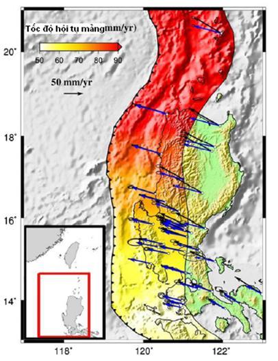
10 SOURCE MODELING After Hsu et al (2012).


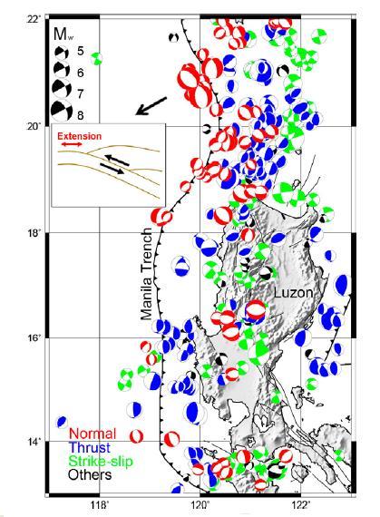
11 SOURCE MODELING After Bautista et al (2001) After Tso-Ren Wu et al (2009)

12 SOURCE MODELING After Kusnowidjaja Megawati et al (2009)

13 SOURCE MODELING The Manila Trench worst case scenario s source model was created assuming a 6-segments fault zone which is capable for a M w 9.3 tsunami generating earthquake. Parameters of each segment is listed bellow.
14 SIMULATION The numerical approach is applied to this study. The well validated open source code, COMCOT (Cornell Multi-grid Coupled Tsunami Model), is chosen to perform the simulation. The COMCOT model is capable of solving both linear and nonlinear shallow water equations in the spherical and Cartesian coordinate systems. The nested grid system can provide tsunami simulations in both deep-water and near-shore coastal regions. The COMCOT model also provides the moving boundary algorithm to simulate the tsunami inundation (Philip L. F. Liu et al, 1998).

15 SIMULATION To estimate the maximum wave heights at different places along the Vietnamese coast, four grid layers are adopted and referred as Grids 1, 2, 3A, and 3B. Finer grid layers, Grids 3A and 3B, are placed in the areas of the two coastal cities Da Nang and Nha Trang, respectively.

16 RESULTS AND APPLICATION Hazards Assessment Maximum free-surface elevation on Grid 1


17 RESULTS AND APPLICATION Hazards Assessment Maximum free-surface elevation on Grid 2 (Central Vietnam coast)

 and Nha Trang")
18 RESULTS AND APPLICATION Hazards Assessment Wave heights maps calculated for Da Nang city (left) and Nha Trang city (right)

19 RESULTS AND APPLICATION Hazards Assessment Sea level station Long Lat Hòn Dáu_Hải Phòng Giao Thủy_Nam Định Cửa Lò Nghệ An Đồng Hới Quảng Bình Đà Nẵng Hội An Núi Thành Quảng Nam Nghĩa An Quảng Ngãi Quy Nhơn Tuy Hòa Nha Trang Ninh Thuận Vũng Tầu (Mũi Nghinh Phong) Cà Mau Location of the sea level stations along the coast

20 RESULTS AND APPLICATION Hazards Assessment

21 RESULTS AND APPLICATION Hazards Assessment


22 RESULTS AND APPLICATION Database Development A field trip was organized to collect data on built-environment and population in Nha Trang city.

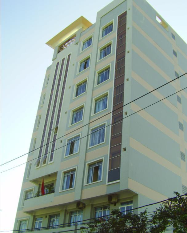
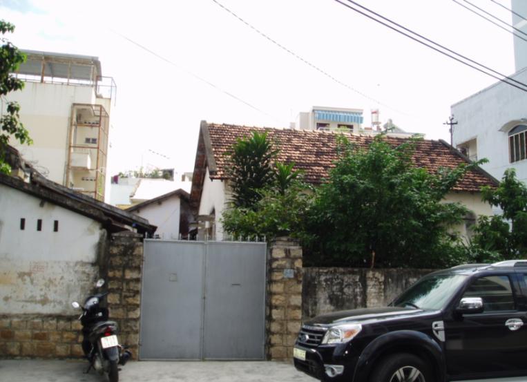
23 RESULTS AND APPLICATION Database Development


24 RESULTS AND APPLICATION Database Development Head-up digitizing the building layer of the Nha Trang city using Google Earth image.


25 RESULTS AND APPLICATION Database Development Create a GIS building inventory database for the study area

26 RESULTS AND APPLICATION Vulnerability and Risk Assessment Built Environment vulnerability map of Nha Trang city

27 RESULTS AND APPLICATION Vulnerability and Risk Assessment Population vulnerability map of Nha Trang: during day time and night time


28 RESULTS AND APPLICATION Vulnerability and Risk Assessment Risk map Inundation map

29 RESULTS AND APPLICATION Response and evacuation Planning Tsunami shelters map for Nha Trang city

30 RESULTS AND APPLICATION Response and evacuation Planning Map of tsunami evacuation zones

31 RESULTS AND APPLICATION Response and evacuation Planning
32 JOINT SYMPOSIUM ON SEISMIC HAZARD ASSESSMENT SENDAI, JAPAN CONCLUSIONS In this study, we create a worst-case scenario of tsunami earthquake excited by Manila Trench mega-thrust and assess the impact to the Vietnamese coast. The source parameters are defined based on the models proposed by Tso- Ren Wu et al (2009) and Megawati K. et al (2009). The earthquake magnitude, Mw, is assumed to be 9.3 generated on the Manila Trench. The tsunami propagation and inundation were numerically computed by using the COMCOT open source code. We focus the discussion in Central Vietnam coastal regions, and carefully describe the maximum tsunami wave heights around two coastal cities, Da Nang and Nha Trang. In Central Vietnam coast, the maximum tsunami wave high of 22 m is observed at the coast of Quang Ngai province. The maximum wave height is 14 m recorded at the coast of Da Nang city and is 12 m at the coast of Nha Trang city. It might be concluded that the tsunami hazards from Manila Trench source are devastating to Vietnamese coast, especially to the Central Vietnam coast. The simulation results can be used for the tsunami hazards/risk assessment as well as warning and response purposes for the coastal zones of the coutry.
33 SIMULATION OF A WORST CASE TSUNAMI SCENARIO FROM THE MANILA TRENCH TO VIETNAM Nguyen Hong Phuong, Vu Ha Phuong, Pham The Truyen Earthquake Information and Tsunami Warning Centre, VAST THANK YOU!
Application of a GIS for Earthquake Hazard Assessment and Risk Mitigation in Vietnam
 Application of a GIS for Earthquake Hazard Assessment and Risk Mitigation in Vietnam Nguyen Hong Phuong Earthquake Information and Tsunami Warning Centre, VAST OUTLINE Introduction Fault Source Model and
NUMERICAL SIMULATION AS GUIDANCE IN MAKING TSUNAMI HAZARD MAP FOR LABUAN ISLAND
 NUMERICAL SIMULATION AS GUIDANCE IN MAKING TSUNAMI HAZARD MAP FOR LABUAN ISLAND MOHD RIDZUAN bin Adam Supervisor: Fumihiko IMAMURA MEE09199 ABSTRACT At the northeast end of the South China Sea, tsunamis
Tsunami hazard risk and early warning projects at Global Geophysics Institute, Vietnam
 Tsunami hazard risk and early warning projects at Global Geophysics Institute, Vietnam presented by Dr Kelvin Berryman, GNS Science, New Zealand k.berryman@gns.cri.nz on behalf of Prof. Bui C. Que,, Director
The potential tsunami threats from the South China Sea and hazard mitigation
 The potential tsunami threats from the South China Sea and hazard mitigation Dr. Tso-Ren Wu ( 吳祚任 ) Graduate Institute of Hydrological and Oceanic Sciences National Central University 國立中央大學水文與海洋科學研究所
Vietnam Coastal Erosion - Cause and Challenges -
 Administration of Sea and Islands Center for Oceanography University of Transport and Communications, Hanoi Vietnam Vietnam Coastal Erosion - Cause and Challenges - Presenters: Pham Hoang KIEN Le Van CONG
Seismic Zoning of Vietnam
 Seismic Zoning of Definition of seismic zones Magnitude discretization SH Seismic Zoning of Smoothing of magnitude Selection of grid points within seismogenic zones SH Seismic Zoning of Distribution of
Current Status of Vietnam Coastal Erosion and Major Measures for Mitigation
 Vietnam Administration of Sea and Islands Center for Oceanography University of Transport and Communications Current Status of Vietnam Coastal Erosion and Major Measures for Mitigation Case Study: Thanh
Preliminary Study of Possible Tsunami Hazards in Taiwan Region
 Preliminary Study of Possible Tsunami Hazards in Taiwan Region Xiaoming Wang and Philip L.-F. Liu Cornell University (First Draft on May 25 2006) (Second Draft on June 1 2006) (Final Update on June 8 2006)
RISK OF TYPHOON AND STORM SURGES IN COASTAL AREAS OF VIETNAM
 RISK OF TYPHOON AND STORM SURGES IN COASTAL AREAS OF VIETNAM Hoang Duc Cuong, Nguyen Ba Thuy, Nguyen Van Huong, Du Duc Tien Vietnam National Center for Hydro-meteorological Forecasting (NCHMF) Hanoi, 26-27
Disclaimer. This report was compiled by an ADRC visiting researcher (VR) from ADRC member countries.
 from ADRC member countries.") Disclaimer This report was compiled by an ADRC visiting researcher (VR) from ADRC member countries. The views expressed in the report do not necessarily reflect the views of the ADRC. The boundaries and
Disclaimer This report was compiled by an ADRC visiting researcher (VR) from ADRC member countries. The views expressed in the report do not necessarily reflect the views of the ADRC. The boundaries and
STUDY ON APPROPRIATE MODELING OF TSUNAMIS IN MALAYSIA FOR RISK EVALUATION
 STUDY ON APPROPRIATE MODELING OF TSUNAMIS IN MALAYSIA FOR RISK EVALUATION Zaty Aktar binti Mokhtar* Supervisor: Fumihiko Imamura** MEE06025 Shunichi Koshimura** ABSTRACT In order to design a tsunami warning
NUMERICAL SIMULATION OF TSUNAMI PROPAGATION AND INUNDATION ALONG THE RAKHINE COAST AREAS IN MYANMAR
 NUMERICAL SIMULATION OF TSUNAMI PROPAGATION AND INUNDATION ALONG THE RAKHINE COAST AREAS IN MYANMAR Su Hninn Htwe Supervisor: Bunichiro SHIBAZAKI MEE12619 Yushiro FUJII ABSTRACT This study aimed to assess
Current tsunami research activities in the Philippines
 DOST PHIVOLCS Current tsunami research activities in the Philippines Graciano P. Yumul, Jr. 1,2, Carla B. Dimalanta 1 and Bart Bautista 3 1 National Institute of Geological Sciences, University of the
VNREDSat-1. Vietnam Natural Resources, Environment and Disaster monitoring Satellite. Lai Anh Khoi SPACE TECHNOLOGY INSTITUTE
 VNREDSat-1 Vietnam Natural Resources, Environment and Disaster monitoring Satellite Lai Anh Khoi SPACE TECHNOLOGY INSTITUTE JPTM2014 Yangon, Nov. 19-21, 2014 General information (1) Project Owner: Vietnam
Earthquakes and Tsunamis
 Earthquakes and Tsunamis Kenji Satake Earthquake Research Institute University of Tokyo 1 Part I 2011 Tohoku earthquake and tsunami 2 Fukushima Dai ichi NPP accident Earthquake ground motion Reactors automatically
2014 Summer training course for slope land disaster reduction Taipei, Taiwan, Aug
 MINISTRY OF SCIENCE AND TECHNOLOGY HYDROTECH RESEARCH INSTITUTE MINISTRY OF NATURAL RESOURCES AND ENVIRONMENT VIETNAM INSTITUTE OF GEOSCIENCES AND MINERAL RESOURCES (VIGMR) 2014 Summer training course
Using Reanalysis SST Data for Establishing Extreme Drought and Rainfall Predicting Schemes in the Southern Central Vietnam
 Using Reanalysis SST Data for Establishing Extreme Drought and Rainfall Predicting Schemes in the Southern Central Vietnam Dr. Nguyen Duc Hau 1, Dr. Nguyen Thi Minh Phuong 2 National Center For Hydrometeorological
PoS(ISGC 2011 & OGF 31)078
078") Modeling scenarios of earthquake-generated tsunamis for Vietnam coasts Davide Bisignano Università degli Studi di Trieste, Department of Geosciences Via E. Weiss 4, Trieste, Italy E-mail: davide.bisignano@gmail.com
Modeling scenarios of earthquake-generated tsunamis for Vietnam coasts Davide Bisignano Università degli Studi di Trieste, Department of Geosciences Via E. Weiss 4, Trieste, Italy E-mail: davide.bisignano@gmail.com
Hazard and Vulnerability of Moderate Seismicity Regions
 Hazard and Vulnerability of Moderate Seismicity Regions presented by Professor Tso-Chien PAN Dean, College of Engineering Director, 25 October 2010 DRM GDLN Session on Earthquake Vulnerability Reduction
Hazard Map Induced by Tsunami - Case Study in Gongliao District
 Center for Weather Climate and Disaster Research Hazard Map Induced by Tsunami - Case Study in Gongliao District Yong-Jun Lin 1, Hsiang-Kuan Chang 2, Kuo-Chen Ma 1, Tso-Ren Wu 3, Jihn-Sung Lai 2, Yih-Chi
TSUNAMI HAZARD ASSESSMENT IN NORTHERN EGYPT USING NUMERICAL SIMULATION
 TSUNAMI HAZARD ASSESSMENT IN NORTHERN EGYPT USING NUMERICAL SIMULATION Abutaleb Ali Supervisor: Bunichiro SHIBAZAKI MEE16717 Yushiro FUJII ABSTRACT To investigate the tsunami hazard along the northern
Wainui Beach Management Strategy (WBMS) Summary of Existing Documents. GNS Tsunami Reports
 Summary of Existing Documents. GNS Tsunami Reports") Wainui Beach Management Strategy (WBMS) Summary of Existing Documents GNS Tsunami Reports a) Review of Tsunami Hazard and Risk in New Zealand ( National Risk Report ) b) Review of New Zealand s Preparedness
Wainui Beach Management Strategy (WBMS) Summary of Existing Documents GNS Tsunami Reports a) Review of Tsunami Hazard and Risk in New Zealand ( National Risk Report ) b) Review of New Zealand s Preparedness
TSUNAMI PROPAGATION AND INUNDATION MODELINGS ALONG SOUTH-EAST COAST OF PAPUA NEW GUINEA
 TSUNAMI PROPAGATION AND INUNDATION MODELINGS ALONG SOUTH-EAST COAST OF PAPUA NEW GUINEA Martin WAREK Supervisor: Yushiro FUJII MEE12620 Bunichiro SHIBAZAKI ABSTRACT This study covers tsunami generation,
Updating a medium-scale landslide database for high-risk areas using community surveys in Vietnam
 On-going program of the State-Funded Landslide Project (SFLP): Updating a medium-scale landslide database for high-risk areas using community surveys in Vietnam Coordinated by: Le Quoc Hung, Pham Van Son,
NUMERICAL SIMULATIONS FOR TSUNAMI FORECASTING AT PADANG CITY USING OFFSHORE TSUNAMI SENSORS
 NUMERICAL SIMULATIONS FOR TSUNAMI FORECASTING AT PADANG CITY USING OFFSHORE TSUNAMI SENSORS Setyoajie Prayoedhie Supervisor: Yushiro FUJII MEE10518 Bunichiro SHIBAZAKI ABSTRACT We conducted numerical simulations
Tsunami Inundation Modeling in the Aegean Sea
 Tsunami Inundation Modeling in the Aegean Sea B. Aydın Akdeniz University, Antalya, Turkey O. Hoto & U. Kânoğlu Middle East Technical University, Ankara, Turkey SUMMARY: The tsunami forecasting system
Investigation, assessment and warning zonation for landslides in the mountainous regions of Vietnam
 Investigation, assessment and warning zonation for landslides in the mountainous regions of Vietnam (State-Funded Landslide Project SFLP) Dr. Eng. Le Quoc Hung Add: 67 Chien Thang Street, Ha Dong District,
Magnitude 7.0 PAPUA, INDONESIA
 A 7.0 magnitude earthquake struck eastern Indonesia's mountainous West Papua province on Saturday but there were no immediate reports of casualties or damage. The region is sparsely populated. According
Indian Ocean Tsunami Warning System: Example from the 12 th September 2007 Tsunami
 Indian Ocean Tsunami Warning System: Example from the 12 th September 2007 Tsunami Charitha Pattiaratchi 1 Professor of Coastal Oceanography, The University of Western Australia Email: chari.pattiaratchi@uwa.edu.au
7.1 FIJI 1, :57:22 UTC
 A magnitude 7.1 earthquake struck 141 km (88 miles) northeast of Ndoi Island, Fiji, and 313 km (194 mi) west-northwest of Nuku alofa, Tonga according to the US Geological Survey, but there were no reports
held on 4 June 2013 Prof. Yoshimori Honkura, Program Officer of Japan Science and Technology Agency (JST) Jakarta, Indonesia Pan Pacific Hotel)
 Jakarta, Indonesia Pan Pacific Hotel)") Overview of the Outcomes from e-asia JRP Disaster Prevention Workshop held on 4 June 2013 Prof. Yoshimori Honkura, Program Officer of Japan Science and Technology Agency (JST) Jakarta, Indonesia (@Sari
Overview of the Outcomes from e-asia JRP Disaster Prevention Workshop held on 4 June 2013 Prof. Yoshimori Honkura, Program Officer of Japan Science and Technology Agency (JST) Jakarta, Indonesia (@Sari
(energy loss is greater with longer wavelengths)
") GEOL 0820 Ramsey Natural Disasters Spring, 2018 LECTURE #9: Tsunami Monitoring & Mitigation Date: 8 February 2018 I. Characteristics (con t): shoaling: o process of wave height increase and breaking as
GEOL 0820 Ramsey Natural Disasters Spring, 2018 LECTURE #9: Tsunami Monitoring & Mitigation Date: 8 February 2018 I. Characteristics (con t): shoaling: o process of wave height increase and breaking as
CLIMATE CHANGE IN VIET NAM: Observed and Future Projection
 2017 ACTS Workshop on Extreme Weather Forecast and Water Resources Management CLIMATE CHANGE IN VIET NAM: Observed and Future Projection Mai Van KHIEM Viet Nam Institute of Meteorology, Hydrology and Climate
APPLICATON OF SEAMLESS SIMULATION OF SEISMIC RESPONSE ANALYSIS AND HIGH RESOLUTION TSUNAMI SIMULATION TO COASTAL AREA OF SENDAI
 Proceedings of the International Symposium on Engineering Lessons Learned from the 2011 Great East Japan Earthquake, March 1-4, 2012, Tokyo, Japan APPLICATON OF SEAMLESS SIMULATION OF SEISMIC RESPONSE
Riskscape module Documentation: Inundation Modelling in Bay of Plenty. X. Wang C. Mueller
 Riskscape module Documentation: Inundation Modelling in Bay of Plenty X. Wang C. Mueller CONTENTS 1.0 GENERAL INFORMATION... 2 1.1 SITE OF STUDY... 5 1.2 SOURCE SCENARIOS... 5 1.3 NUMERICAL MODEL... 5
Sendai Earthquake NE Japan March 11, Some explanatory slides Bob Stern, Dave Scholl, others updated March
 Sendai Earthquake NE Japan March 11, 2011 Some explanatory slides Bob Stern, Dave Scholl, others updated March 14 2011 Earth has 11 large plates and many more smaller ones. Plates are 100-200 km thick
Cascadia Seismic Event Planning for the Maritime Community
 Cascadia Seismic Event Planning for the Maritime Community Jonathan Allan, Oregon Dept. of Geology and Mineral Industries Presentation to Annual Pacific Northwest Waterways Association Meeting (PNWA) October
Earthquakes Physical Geology 2017 Part 1: Exploring Earthquake distributions. Home butto California Earthquakes: 1) 2) 3) above
 2) 3) above") Earthquakes Physical Geology 2017 Adapted from a lab by Jennifer Wenner This lab is designed to give you experience exploring seismicity associated with different plate boundaries. You will examine seismograms
Earthquakes Physical Geology 2017 Adapted from a lab by Jennifer Wenner This lab is designed to give you experience exploring seismicity associated with different plate boundaries. You will examine seismograms
News Release December 30, 2004 The Science behind the Aceh Earthquake
 News Release December 30, 2004 The Science behind the Aceh Earthquake PASADENA, Calif. - Kerry Sieh, the Robert P. Sharp Professor of Geology at the California Institute of Technology and a member of Caltech's
EARTHQUAKE SOURCE PARAMETERS FOR SUBDUCTION ZONE EVENTS CAUSING TSUNAMIS IN AND AROUND THE PHILIPPINES
 EARTHQUAKE SOURCE PARAMETERS FOR SUBDUCTION ZONE EVENTS CAUSING TSUNAMIS IN AND AROUND THE PHILIPPINES Joan Cruz SALCEDO Supervisor: Tatsuhiko HARA MEE09186 ABSTRACT We have made a set of earthquake source
REAL-TIME TSUNAMI INUNDATION FORECAST STUDY IN CHIMBOTE CITY, PERU
 REAL-TIME TSUNAMI INUNDATION FORECAST STUDY IN CHIMBOTE CITY, PERU Nabilt Moggiano Supervisor: Kenji SATAKE MEE16720 ABSTRACT For rapid forecast of tsunami inundation during a tsunamigenic event, we constructed
Lessons Learned from Past Tsunamis Warning and Emergency Response
 UNESCO IOC CTIC US NOAA ITIC Regional Training Workshop on Strengthening Tsunami Warning and Emergency Response Standard Operating Procedures and the Development of the ICG/CARIBE-EWS PTWC New Enhanced
Preliminary numerical simulation of potential earthquake-induced tsunami in East China Sea
 Vol.1 No.5 (456~463) ACTA SEISMOLOGICA SINICA Sep., 008 Article ID: 1000-9116(008)05-0456-08 doi: 10.1007/s11589-008-0456-1 Preliminary numerical simulation of potential earthquake-induced tsunami in East
2. Tsunami Source Details
 2. Tsunami Source Details The Northland area faces a range of potential tsunamigenic sources that include several local and distant fault systems and underwater landslides. A NIWA study (Goff et al. 2006)
New Tsunami Disaster Mitigation System considering Local Conditions of Indian Ocean Rim Regions
 New Tsunami Disaster Mitigation System considering Local Conditions of Indian Ocean Rim Regions Kimiro Meguro Professor, Institute of Industrial Science, The University of Tokyo, Japan Shunichi Koshimura
Magnitude 7.1 NEAR THE EAST COAST OF HONSHU, JAPAN
 Japan was rattled by a strong aftershock and tsunami warning Thursday night nearly a month after a devastating earthquake and tsunami flattened the northeastern coast. This earthquake can be considered
Coseismic slip model
 Figure 3 - Preliminary highly smoothed model of coseismic slip for the 11 March UCL Institute for Risk & Disaster Reduction Magnitude 9.0 (JMA scale) earthquake Occurred at 02:46:23 pm local time near
DATA BASE DEVELOPMENT OF ETA (ESTIMATED TIME OF ARRIVAL) FOR TSUNAMI DISASTER MITIGATION AT SOUTHWESTERN CITIES OF ACEH, INDONESIA
 FOR TSUNAMI DISASTER MITIGATION AT SOUTHWESTERN CITIES OF ACEH, INDONESIA") 6 th South China Sea Tsunami Workshop Nanyang Technology University, Singapore, 6-8 November 2013 DATA BASE DEVELOPMENT OF ETA (ESTIMATED TIME OF ARRIVAL) FOR TSUNAMI DISASTER MITIGATION AT SOUTHWESTERN
6 th South China Sea Tsunami Workshop Nanyang Technology University, Singapore, 6-8 November 2013 DATA BASE DEVELOPMENT OF ETA (ESTIMATED TIME OF ARRIVAL) FOR TSUNAMI DISASTER MITIGATION AT SOUTHWESTERN
Preparation for Future Earthquake and Tsunami Hazards: Lessons Learned from the 2004 Sumatra-Andaman Earthquake and the Asian Tsunami
 First International Conference of Aceh and Indian Ocean Studies Organized by Asia Research Institute, National University of Singapore & Rehabilitation and Construction Executing Agency for Aceh and Nias
The ITSU System in the Pacific Region and Future Upgrades
 The ITSU System in the Pacific Region and Future Upgrades Eddie Bernard Director, Pacific Marine Environmental Laboratory (PMEL) NOAA/USA Pacific Tsunami Warning Center OPERATIONAL ACTIVITIES SEISMIC DATA
HEAVY RAIN OVER MID-CENTRAL REGION OF VIETNAM
 HEAVY RAIN OVER MID-CENTRAL REGION OF VIETNAM ----------------------------------------------------------------------- S.Eng. Dang Thi Mai; Dr. Nguyen Thi Tan Thanh National Hydro Meteorological Service
FOCAL MECHANISMS OF SUBDUCTION ZONE EARTHQUAKES ALONG THE JAVA TRENCH: PRELIMINARY STUDY FOR THE PSHA FOR YOGYAKARTA REGION, INDONESIA
 FOCAL MECHANISMS OF SUBDUCTION ZONE EARTHQUAKES ALONG THE JAVA TRENCH: PRELIMINARY STUDY FOR THE PSHA FOR YOGYAKARTA REGION, INDONESIA Myo Thant 1, Hiroshi Kawase 2, Subagyo Pramumijoyo 3, Heru Hendrayana
What Are Disasters? The Rescue Kids Trio!
 The Rescue Kids Trio! What Are Disasters? This manual was made possible through funding by the Council of Local Authorities for International Relations. Disasters and emergency preparedness Emergency preparedness
Tsunami waves swept away houses and cars in northern Japan and pushed ships aground.
 Japan was struck by a magnitude 8.9 earthquake off its northeastern coast Friday. This is one of the largest earthquakes that Japan has ever experienced. In downtown Tokyo, large buildings shook violently
Earthquake Hazards. Tsunami
 Earthquake Hazards Tsunami Measuring Earthquakes Two measurements that describe the power or strength of an earthquake are: Intensity a measure of the degree of earthquake shaking at a given locale based
Three Dimensional Simulations of Tsunami Generation and Propagation
 Chapter 1 Earth Science Three Dimensional Simulations of Tsunami Generation and Propagation Project Representative Takashi Furumura Authors Tatsuhiko Saito Takashi Furumura Earthquake Research Institute,
International Symposium on Natural Disaster Mitigation. Local vulnerability assessment of landslides and debris flows
 International Symposium on Natural Disaster Mitigation of landslides and debris flows Lessons learnt from Cam Pha town and Van Don district, Quang Ninh province, Vietnam Nguyen Quoc Phi Faculty of Environment
Predicting of Tsunami Inundation Area based on Propagation and Runup Numerical Model in Pacitan City
 Predicting of Tsunami Inundation Area based on Propagation and Runup Numerical Model in Pacitan City 1 Agus Suharyanto, 1 Alwafi Pujiraharjo, 2 Adipandang Yudono, 3 Keisuke Murakami, and 3 Chikashi Deguchi
SUPPLEMENTAL MATERIAL. Modulation of Daily Rainfall in Southern Vietnam by the Madden-Julian. Oscillation and Convectively Coupled Equatorial Waves
 SUPPLEMENTAL MATERIAL Modulation of Daily Rainfall in Southern Vietnam by the Madden-Julian Oscillation and Convectively Coupled Equatorial Waves Roderick van der Linden 1 Institute for Geophysics and
Evaluation of Tsunami Risk Posed to Sri Lanka by Potential Mega-Thrust Earthquakes in the Makran Subduction Zone
 1 ENGINEER - Vol. XXXXII, No. 01, pp. [21-28], 2009 The Institution of Engineers, Sri Lanka Evaluation of Tsunami Risk Posed to Sri Lanka by Potential Mega-Thrust Earthquakes in the Makran Subduction Zone
The 2011 Tohoku Earthquake and Tsunami Sequence. Mitchell May, EPSC 330
 The 2011 Tohoku Earthquake and Tsunami Sequence Mitchell May, 260556044 EPSC 330 The 2011 earthquake sequence east of Tohoku is classified as a megathrust earthquake off the east coast of Japan. The earthquake
Assessment of tsunami threat to Sri Lanka from potential mega-thrust earthquakes in the Arakan subduction zone
 J.Natn.Sci.Foundation Sri Lanka 2010 38 (2): 101-108 RESEARCH ARTICLE Assessment of tsunami threat to Sri Lanka from potential mega-thrust earthquakes in the Arakan subduction zone Janaka J. Wijetunge
Magnitude 8.3 SEA OF OKHOTSK
 A powerful earthquake in Russia's Far East was felt as far away as Moscow, about 7,000 kilometers (4,400 miles) west of the epicenter, but no casualties or damage were reported. The epicenter was in the
Tsunami Response and the Enhance PTWC Alerts
 Tsunami Response and the Enhance PTWC Alerts Ken Gledhill GeoNet Project Director Chair, Intergovernmental Coordination Group, Pacific Tsunami Warning and Mitigation System (PTWS) Overview 1. Procedures
Tsunami hazard assessment along the Chinese mainland coast from earthquakes in the Taiwan region
 DOI 10.1007/s11069-015-2133-8 ORIGINAL PAPER Tsunami hazard assessment along the Chinese mainland coast from earthquakes in the Taiwan region Hou Jingming 1,2 Li Xiaojuan 1 Yuan Ye 2 Wang Peitao 2 Received:
MINISTRY OF NATURAL RESOURCES AND ENVIRONMENT
 MINISTRY OF NATURAL RESOURCES AND ENVIRONMENT HÀ NỘI, 2016 CLIMATE CHANGE AND SEA LEVEL RISE SCENARIOS FOR VIET NAM SPM Summary for policymakers Main authors: Tran Thuc, Nguyen Van Thang, Huynh Thi Lan
Tsunami and earthquake in Chile Part 2
 EUROPEAN COMMISSION DIRECTORATE GENERAL JRC JOINT RESEARCH CENTRE Institute for the Protection and Security of the Citizen Global Security and Crisis Management Unit CriTech Sunday, 28 February 2010 Executive
MEMBER REPORT. ESCAP/WMO Typhoon Committee 7 th Integrated Workshop SOCIALIST REPUBLIC OF VIET NAM
 MEMBER REPORT ESCAP/WMO Typhoon Committee th Integrated Workshop SOCIALIST REPUBLIC OF VIET NAM Nanjing, China 26-30 November 202 CONTENTS I. Overview of tropical cyclones which have affected/impacted
Earthquake Hazards. Tsunami
 Earthquake Hazards Tsunami Review: What is an earthquake? Earthquake is the vibration (shaking) and/or displacement of the ground produced by the sudden release of energy. The point inside the Earth where
D DAVID PUBLISHING. 1. Introduction. 2. Methodology. Truong Thanh Phi
 Journal of Geological Resource and Engineering 2 (2016) 81-88 doi:10.17265/2328-2193/2016.02.004 D DAVID PUBLISHING Some Results of Quantitative Analysis of Fracture Orientation Distribution along the
RESPONSE TO TYPHOON HAIYAN IN VIET NAM
 RESPONSE TO TYPHOON HAIYAN IN VIET NAM Dr. Nguyen Dai Khanh Mr. Vo Van Hoa ESCAP/WMO typhoon Committee 8 th IWS/2 nd TRCG Forum Ma Cau, 02-06 December 2013 Introduction TY Haiyan-1330 In the morning 04/11,
What is a tsunami? Capital Regional District Tsunami Frequently Asked Questions (FAQ s) Tsunami (soo-nah-mee)
 Tsunami (soo-nah-mee)") Tsunami (soo-nah-mee) Tsunamis (Japanese translation harbour wave ) are waves with a great distance between crests, and are caused by any widespread, sudden movement of large volumes of water. The tsunami
Tsunami (soo-nah-mee) Tsunamis (Japanese translation harbour wave ) are waves with a great distance between crests, and are caused by any widespread, sudden movement of large volumes of water. The tsunami
EVALUATION OF THE VULNERABILITY OF TitleCOASTAL SOCIO-NATURAL SYSTEMS (EXAM FROM KHANH HOA COASTAL ZONE) Author(s) Nguyen, Thi Thuy Hang; Pham, Hung T
 Author(s) Nguyen, Thi Thuy Hang; Pham, Hung T") EVALUATION OF THE VULNERABILITY OF TitleCOASTAL SOCIO-NATURAL SYSTEMS (EXAM FROM KHANH HOA COASTAL ZONE) Author(s) Mai, Trong Nhuan; Tran, Thanh Hai; Nguyen, Thi Thuy Hang; Pham, Hung T Annual Report of
EVALUATION OF THE VULNERABILITY OF TitleCOASTAL SOCIO-NATURAL SYSTEMS (EXAM FROM KHANH HOA COASTAL ZONE) Author(s) Mai, Trong Nhuan; Tran, Thanh Hai; Nguyen, Thi Thuy Hang; Pham, Hung T Annual Report of
TSUNAMI CHARACTERISTICS OF OUTER-RISE EARTHQUAKES ALONG THE PACIFIC COAST OF NICARAGUA - A CASE STUDY FOR THE 2016 NICARAGUA EVENT-
 TSUNAMI CHARACTERISTICS OF OUTER-RISE EARTHQUAKES ALONG THE PACIFIC COAST OF NICARAGUA - A CASE STUDY FOR THE 2016 NICARAGUA EVENT- Amilcar Cabrera Supervisor: Yuichiro TANIOKA MEE16718 ABSTRACT Nicaragua
Mathematical models for estimating earthquake casualties and damage cost through regression analysis using matrices
 Journal of Physics: Conference Series OPEN ACCESS Mathematical models for estimating earthquake casualties and damage cost through regression analysis using matrices To cite this article: J D Urrutia et
The challenge of risk communication how risk communication is the key to triggering action: Experiences from the Philippines and PNG
 The challenge of risk communication how risk communication is the key to triggering action: Experiences from the Philippines and PNG Dr Andrew Jones on behalf of the Regional Development Group and partners
e-science on Earthquake Disaster Mitigation in Taiwan
 e-science on Earthquake Disaster Mitigation in Taiwan Eric Yen EGI User Forum, April 2011 ~50 earthquakes/day Taiwan Seismicity on Google Earth 0 15 30 70 100 150 km Eurasia Plate S01R Philippine Sea Plate
SCIENCE OF TSUNAMI HAZARDS
 SCIENCE OF TSUNAMI HAZARDS ISSN 8755-6839 Journal of Tsunami Society International Volume 31 Number 4 2012 RESPONSE OF THE GDACS SYSTEM TO THE TOHOKU EARTHQUAKE AND TSUNAMI OF 11 MARCH 2011 Annunziato,
Introduction to Environmental Geology, 5e Case History: Indonesian Tsunami Indonesian Tsunami (2) Introduction Historic Tsunamis
 Introduction Historic Tsunamis") 1 2 3 4 5 6 7 8 9 Introduction to Environmental Geology, 5e Chapter 7 Tsunami Case History: Indonesian Tsunami December 26, 2004, within a few hours, close to 250,000 people were killed With no warning
1 2 3 4 5 6 7 8 9 Introduction to Environmental Geology, 5e Chapter 7 Tsunami Case History: Indonesian Tsunami December 26, 2004, within a few hours, close to 250,000 people were killed With no warning
Status after Six Years
 German-Indonesian Tsunami Early Warning System () Status after Six Years Joern Lauterjung and the -Team Challenge Indonesia Short Early Warning Time Tsunamis are generated at the trench (orange line) Traveltimes
Establishment and Operation of a Regional Tsunami Warning Centre
 Establishment and Operation of a Regional Tsunami Warning Centre Dr. Charles McCreery, Director NOAA Richard H. Hagemeyer Pacific Tsunami Warning Center Ewa Beach, Hawaii USA Why A Regional Tsunami Warning
Appendix A Health and Safety Retrospective Appendix B - Acknowledgements. 7. References 47
 Contents Page No. 1. Introduction 2 2. Numerical Modelling of Tsunami 2.1. Submarine earthquake models 5 2.2. Tsunami propagation models 6 2.3. Boundary conditions 8 2.4. COMCOT 8 3. Model Verification
"The Natural Disasters, like The Sumatra Tsunami had taught us before -BUT" U Than Myint President Myanmar Engineering Society
 "The Natural Disasters, like The Sumatra Tsunami had taught us before -BUT" U Than Myint President Myanmar Engineering Society Present Day Regional Tectonic Setting of South East Asia Tsunami-generated
SCIENCE OF TSUNAMI HAZARDS
 SCIENCE OF TSUNAMI HAZARDS ISSN 8755-6839 Journal of Tsunami Society International Volume 29 Number 3 2010 POTENTIAL DEFICIENCIES IN EDUCATION, INSTRUMENTATION, AND WARNINGS FOR LOCALLY GENERATED TSUNAMIS
Sea Level Rise and Storm surges: High Stakes for a Small Number of Developing Countries
 Sea Level Rise and Storm surges: High Stakes for a Small Number of Developing Countries Susmita Dasgupta Benoit Laplante Siobhan Murray David Wheeler DECEE The World Bank March, 2009 Objective of our Study
TSUNAMI AND EARTHQUAKE ACTIVITY IN INDONESIA *
 LOCAL TSUNAMI WARNING AND MITIGATION TSUNAMI AND EARTHQUAKE ACTIVITY IN INDONESIA * Nanang T. Puspito Department of Geophysics and Meteorology, Institute of Technology Bandung (ITB) Address: Jalan Ganeca
ME KONG RIVER COMMISSION FLASH FLOOD GUIDANCE SYSTEM (MRCFFGS)
") NATIONAL HYDRO-METEOROLOGICAL SERVICE IN VIETNAM NATIONAL CENTER FOR HYDRO-METEOROLOGICAL FORECASTING ME KONG RIVER COMMISSION FLASH FLOOD GUIDANCE SYSTEM (MRCFFGS) http://www.nchmf.gov.vn 29 Nov 1 Dec
NATIONAL HYDRO-METEOROLOGICAL SERVICE IN VIETNAM NATIONAL CENTER FOR HYDRO-METEOROLOGICAL FORECASTING ME KONG RIVER COMMISSION FLASH FLOOD GUIDANCE SYSTEM (MRCFFGS) http://www.nchmf.gov.vn 29 Nov 1 Dec
Earthquake Hazards. Tsunami
 Earthquake Hazards Tsunami Review: What is an earthquake? Earthquake is the vibration (shaking) and/or displacement of the ground produced by the sudden release of energy. The point inside the Earth where
DEVASTATING DAMAGE DUE TO THE 2004 INDIAN OCEAN TSUNAMI AND ITS LESSONS
 DEVASTATING DAMAGE DUE TO THE 2004 INDIAN OCEAN TSUNAMI AND ITS LESSONS Fumihiko Imamura 1 1 Professor, Tsunami Engineering, Disaster Control Research Center, Tohoku University, Japan Email: imamura@tsunami2.civil.tohoku.ac.jp
THE 2011 TOHOKU EARTHQUAKE IN JAPAN. VSU Lyuben Karavelov, Sofia, Bulgaria. Key words: Tohoku earthquake, strong ground motion, damage
 THE 2011 TOHOKU EARTHQUAKE IN JAPAN Radan Ivanov 1 VSU Lyuben Karavelov, Sofia, Bulgaria Abstract: This earthquake which occurred on March 11, 2011, had a magnitude of 9.0, which places it as the fourth
SIMULATION OF FUTURE ANDAMAN TSUNAMI INTO STRAITS OF MALACCA BY TUNA
 Journal of Earthquake and Tsunami, Vol. 3, No. 2 (29) 89 1 c World Scientific Publishing Company SIMULATION OF FUTURE ANDAMAN TSUNAMI INTO STRAITS OF MALACCA BY TUNA KOH HOCK LYE,, TEH SU YEAN,KEWLEEMING
Introduction to Environmental Geology, 5e
 Lecture Presentation prepared by X. Mara Chen, Salisbury University Introduction to Environmental Geology, 5e Edward A. Keller Chapter 7 Tsunami Case History: Indonesian Tsunami December 26, 2004, within
Tsunami Risk Reduction Measures Phase 2
 Tsunami Risk Reduction Measures Phase 2 November 2009 Cover pictures; Initial water displacements (m) for the three northernmost Sunda Arc scenarios of magnitude M 8.55, 8.53 and 8.60 respectively, as
Earthquake and Tsunami Modeling in Japan. Renee Lee Product Manager, RMS
 Earthquake and Tsunami Modeling in Japan Renee Lee Product Manager, RMS RMS JAPAN EARTHQUAKE MODEL HISTORY 2011 GREAT EAST JAPAN EARTHQUAKE M9.0 SCOPE OF JAPAN EARTHQUAKE MODEL UPDATE (2012) Event Rate
Magnitude 7.0 N of ANCHORAGE, ALASKA
 A magnitude 7.0 earthquake occurred just before 8:30 am local time 8 miles north of Anchorage at a depth of 40.9 km (25.4 miles). There are reports of major infrastructure damage and damage to many homes
Lessons from the 2004 Sumatra earthquake and the Asian tsunami
 Lessons from the 2004 Sumatra earthquake and the Asian tsunami Kenji Satake National Institute of Advanced Industrial Science and Technology Outline 1. The largest earthquake in the last 40 years 2. Tsunami
Probabilistic Tsunami Hazard Analysis. Hong Kie Thio AECOM, Los Angeles
 Probabilistic Tsunami Hazard Analysis Hong Kie Thio AECOM, Los Angeles May 18, 2015 Overview Introduction Types of hazard analysis Similarities and differences to seismic hazard Methodology Elements o
RELOCATION OF LARGE EARTHQUAKES ALONG THE PHILIPPINE FAULT ZONE AND THEIR FAULT PLANES
 RELOCATION OF LARGE EARTHQUAKES ALONG THE PHILIPPINE FAULT ZONE AND THEIR FAULT PLANES Rey M. Lumbang MEE12608 Supervisor: Nobuo Hurukawa ABSTRACT We relocated large magnitude (Mw 7.0) earthquakes that
Magnitude 7.7 QUEEN CHARLOTTE ISLANDS REGION
 A major 7.7 magnitude earthquake struck at 8:04 PM local time in western British Columbia, Canada. The epicenter is located on Moresby Island, the southern large island in the Queen Charlotte Islands region.
Predicting tsunami waves and currents on the West Coast of Canada: A case study for Ucluelet, BC
 Predicting tsunami waves and currents on the West Coast of Canada: A case study for Ucluelet, BC Josef Cherniawsky, Kelin Wang and Roy Walters Institute of Ocean Sciences, Fisheries & Oceans Canada Pacific