2014 Summer training course for slope land disaster reduction Taipei, Taiwan, Aug
|
|
|
- Linda Miller
- 5 years ago
- Views:
Transcription
 2014 Summer training course for slope land disaster reduction Taipei, Taiwan, Aug.")
1 MINISTRY OF SCIENCE AND TECHNOLOGY HYDROTECH RESEARCH INSTITUTE MINISTRY OF NATURAL RESOURCES AND ENVIRONMENT VIETNAM INSTITUTE OF GEOSCIENCES AND MINERAL RESOURCES (VIGMR) 2014 Summer training course for slope land disaster reduction Taipei, Taiwan, Aug PROJECT REPORT SON LE MINH CHANH PHAM VIET

2 Vietnam Introduction Vietnam is located in the center of the Southeast Asia, and is shaped like the letter "S". The country lies in the eastern part of the Indochina peninsula, bordered by China to the north, Laos and Cambodia to the west, and the East Sea and Pacific Ocean to the southeast. Vietnam's coast line is 3,260 km long and its inland border measures 3,730 km. Vietnam has a population of more than 90 million people, comprised of 54 different ethnic groups that possess historically rich cultural backgrounds and interesting folk arts. The country has more than 1,000 historical, cultural, and architectural sites which have been officially classified as "Heritage Sites". Five of these sites have been recognized as world cultural heritage sites by UNESCO (United Nations Educational and Scientific Cultural Organization), including Halong Bay, Phong Nha - Ke Bang National park, the ancient capital of Hue, the ancient town Hoi An, and My Son Holy Land
3 Vietnam Introduction Vietnam is located in the tropical monsoon area, one of the storm-prone areas in the Asia Pacific region. Typhoon usually accompany with high tide and heavy rain, thus resulting in heavy and long rains, causing various types of natural disasters, especially landslides, flash flood, debris flow in hilly and mountainous areas. Hills and mountains in Vietnam cover 3/4 of land area, therefore approximately 70% of the mountainous areas in this country (37/63 provinces and cities) have been annually affected by landslides (debris flow, flash floods). This type of natural disasters have been increasingly severe in terms of magnitude, frequency and volatility, causing vast losses in human life, property, socio-economic and cultural infrastructure as well as environmental

 burried 19 people in Mu Cang Chai in 2012")
 block a national highway in Hoa Binh in")

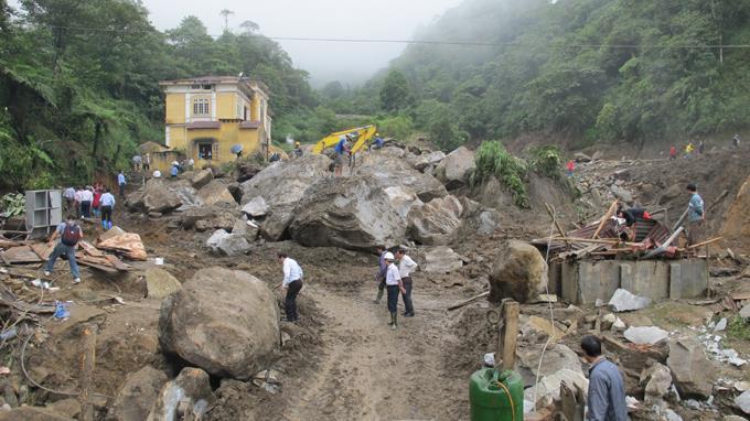
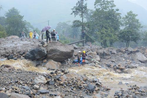
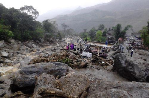
4 LANDSLIDE IN VIET NAM Landslides burried 23 people in Sung Hoang village, Phin Ngan commune, Lao Cai province in 9/2004. A large landslide (~ m 3 ) burried 19 people in Mu Cang Chai in 2012 during a heavy rain A large landslide (~ m 3 ) block a national highway in Hoa Binh in 2012, ~ 10 days after a series of long duration rains A small landslide burried 6 people of a family in Lao Cai in 2012 after > 10 raining days


5 FLOOD, FLASHFLOOD, DEBRIS FLOW IN VIET NAM people killed, missing by typhoon Nari, On 09/30/2013, Wutip typhoon : 9 people dead, 199 people injured, damage trillion /2011, floods in middle of Viet Nam: 55 died. Floodwaters have submerged about 170,000 homes and 23,700 hectares of crops /2010, torrential rains, the water floods up "super speed" unprecedented in 100 years submerged in sea water Huong Khe district, Ha Tinh province. 5. In 2008, floods in Lao Cai province, 144 dead and missing. 6. 8/1996, Niki storm in the North, 65 people dead and missing in the North of Viet Nam 7. 7/1986 floods, 121 dead in mountainous regions North of Viet Nam
6

7 Statistics of flash floods, debris flow from 1958 to 2004 in Viet Nam >
8 MINISTRY OF NATURAL RESOURCES AND ENVIRONMENT VIETNAM INSTITUTE OF GEOSCIENCES AND MINERAL RESOURCES (VIGMR) Investigation, assessment and warning zonation of landslides in mountainous regions of Vietnam From 2012 to The government s project
9 OBJECTIVES AND TARGETS 1. Defining the current situation, causes and effects, warning zonation of landslide hazards in the Vietnamese mountainous areas, recommendation of measures for prevention, preparedness and mitigation; 2. Establishing a standard national database on landslides as a scientific base to improve the capacity building in disaster warning and preparedness, for the planning and sustainable development in the mountainous areas of Vietnam; 3. Creating an atlas of warning zones for landslide hazards in mountainous areas from the Central level to community level; 4. Determining a scientific foundation for setting up a network of observation and monitoring station for early warning of natural disasters in general and of landslides in particular in the Vietnamese mountains; 5. Designing an early warning system for landslide hazard and installing a pilot network of observation and monitoring stations in some typical areas.
10 IMPLEMENTATION PHASES AND DURATION 1. Phase I: (4 years): - Investigation and warning zonation of landslide hazards in 17 Northern mountainous provinces - Implementation of a pilot network for landslide hazard observation and monitoring stations at high hazard locations. 2. Phase II (3 years): - Investigation and warning zonation of landslide hazards in 13 Central, 5 Highland and 2 Southeastern mountainous provinces; - Detail investigation at large scales (1/ to 1/2000) for high hazard areas; proposal of landside early warning system in 17 Northern mountainous provinces. 3. Phase III (4 years): - Detail investigation at large scales (1/ to 1/2000) for high hazard areas and installation of landside early warning system in the Central, Highland and Southeastern mountainous provinces.

11 Landslide inventory maping for 10 northern provinces ( ) 1. Inventory from historical records 2. Image interpretation (Stereoscopic aerial photographs) 3. Field investigation

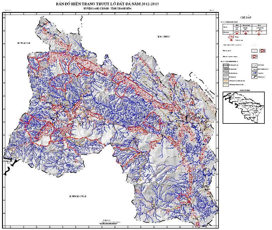
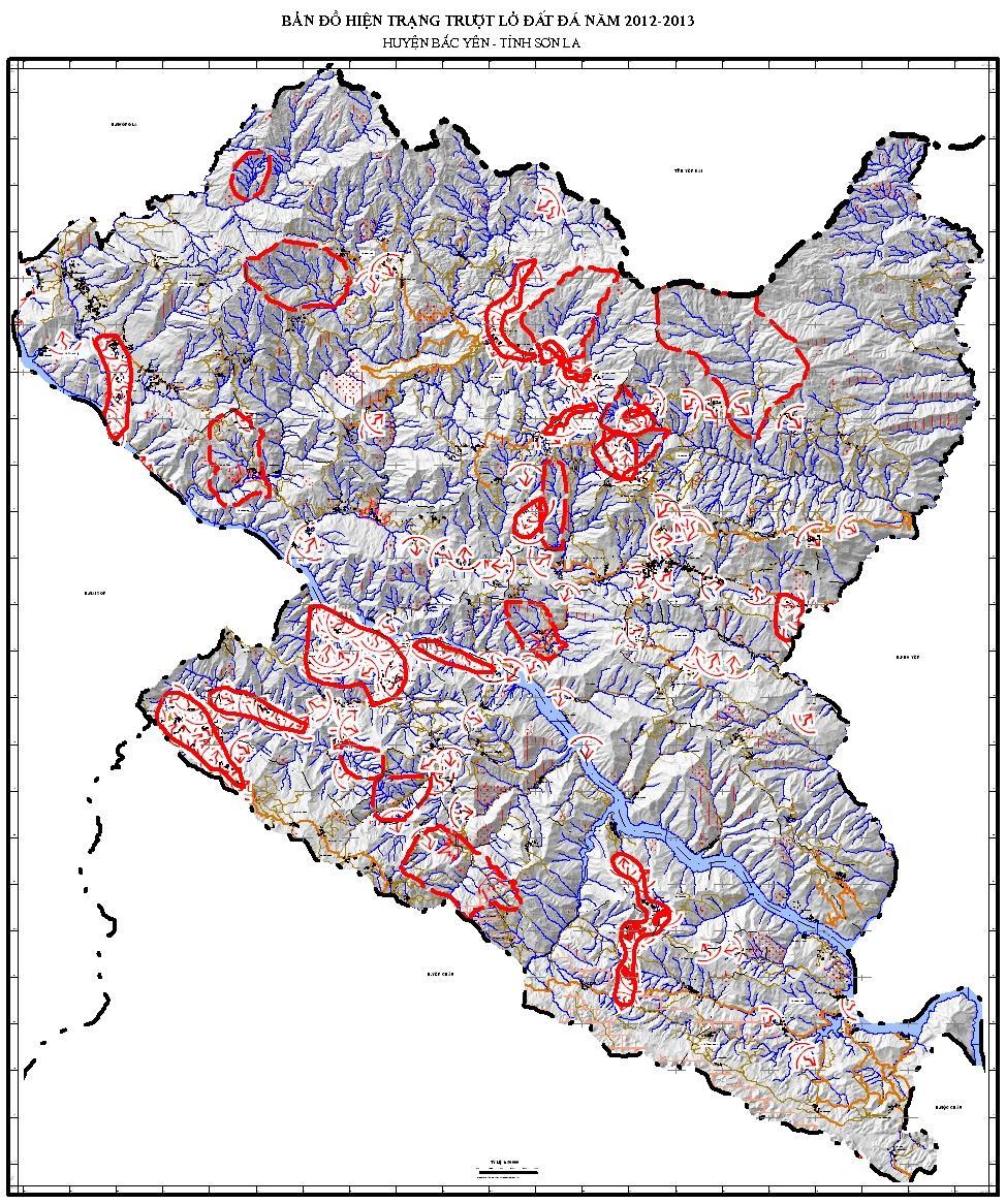
12 Landslide inventory map


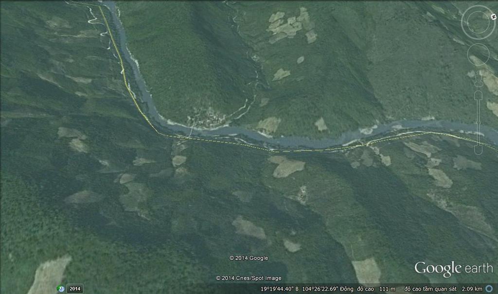
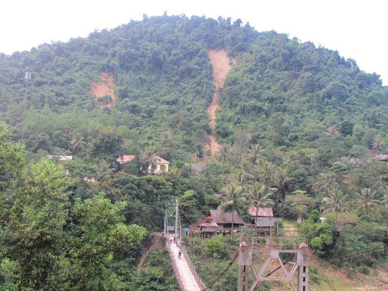
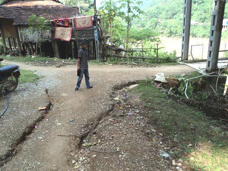
13 Case study Xop Mat village is about 183 km to the west from Vinh City, Nghe An province and about 400 km away from Hanoi (Tuong Duong District). XopMat village DEM of Tuong Duong Landslide occurs after heavy rains on 11/06/2011
14
15 FACTORS TRIGGER Geological condition: Ca River Formation, lower Subformation (O 3 -S 1 sc 3 ): Slate quartz sericite, sericite schist, sandy siltstone, sandstone, medium grain small. Because of the active fault zone that runs along the Nam Non springs were crushed rocks, compression and break strongly. The cracked on the top create conditions for water infiltration into the sliding surface lubrication effect and reduces the shear strength of the soil caused movement. Topography - geomorphology: regional topography slopes from 130m altitude up to 250 m altitude is 35 o -40 o. Rainfall: >200mm/2days.


16 Monitoring and Early warning System o Inclinometers o Piezometers o Extensometers o Rain gauge o Water level sensor
17 MINISTRY OF SCIENCE AND TECHNOLOGY HYDROTECH RESEARCH INSTITUTE MINISTRY OF NATURAL RESOURCES AND ENVIRONMENT VIETNAM INSTITUTE OF GEOSCIENCES AND MINERAL RESOURCES (VIGMR) THANKS FOR YOUR ATTENTION 2014 Summer training course for slope land disaster reduction Taipei, Taiwan, Aug
Investigation, assessment and warning zonation for landslides in the mountainous regions of Vietnam
 Investigation, assessment and warning zonation for landslides in the mountainous regions of Vietnam (State-Funded Landslide Project SFLP) Dr. Eng. Le Quoc Hung Add: 67 Chien Thang Street, Ha Dong District,
Updating a medium-scale landslide database for high-risk areas using community surveys in Vietnam
 On-going program of the State-Funded Landslide Project (SFLP): Updating a medium-scale landslide database for high-risk areas using community surveys in Vietnam Coordinated by: Le Quoc Hung, Pham Van Son,
MINISTRY OF NATURAL RESOURCES AND ENVIRONMENT Vietnam Institute of Geosciences and Mineral Resources (VIGMR)
") MINISTRY OF NATURAL RESOURCES AND ENVIRONMENT (VIGMR) Nguyen Quoc Dinh Representative of VIGMR to Sentinel Asia Awaji, Japan, November 1 st,2018 CONTENTS INTRODUCTION TO VIGMR COOPERATION and CONTRIBUTION
MINISTRY OF NATURAL RESOURCES AND ENVIRONMENT (VIGMR) Nguyen Quoc Dinh Representative of VIGMR to Sentinel Asia Awaji, Japan, November 1 st,2018 CONTENTS INTRODUCTION TO VIGMR COOPERATION and CONTRIBUTION
International Symposium on Natural Disaster Mitigation. Local vulnerability assessment of landslides and debris flows
 International Symposium on Natural Disaster Mitigation of landslides and debris flows Lessons learnt from Cam Pha town and Van Don district, Quang Ninh province, Vietnam Nguyen Quoc Phi Faculty of Environment
Natural Disasters in Member Countries (2002 Summary)
") 4.2 Member Countries and their Disaster Characteristics: Table 5: Natural Disasters in Member Countries (2002 Summary) (Country/Disaster Type/Disaster Characteristics) Data Country DisType Count of TotAff
4.2 Member Countries and their Disaster Characteristics: Table 5: Natural Disasters in Member Countries (2002 Summary) (Country/Disaster Type/Disaster Characteristics) Data Country DisType Count of TotAff
Vietnam Coastal Erosion - Cause and Challenges -
 Administration of Sea and Islands Center for Oceanography University of Transport and Communications, Hanoi Vietnam Vietnam Coastal Erosion - Cause and Challenges - Presenters: Pham Hoang KIEN Le Van CONG
Recent development of the National Hydro-Meteorological Service (NHMS) of Viet Nam for disaster risk reduction
 of Viet Nam for disaster risk reduction") Ministry of Natural Resources and Environment National Hydro-Meteorological Service Recent development of the National Hydro-Meteorological Service (NHMS) of Viet Nam for disaster risk reduction Tran Van
Ministry of Natural Resources and Environment National Hydro-Meteorological Service Recent development of the National Hydro-Meteorological Service (NHMS) of Viet Nam for disaster risk reduction Tran Van
ME KONG RIVER COMMISSION FLASH FLOOD GUIDANCE SYSTEM (MRCFFGS)
") NATIONAL HYDRO-METEOROLOGICAL SERVICE IN VIETNAM NATIONAL CENTER FOR HYDRO-METEOROLOGICAL FORECASTING ME KONG RIVER COMMISSION FLASH FLOOD GUIDANCE SYSTEM (MRCFFGS) http://www.nchmf.gov.vn 29 Nov 1 Dec
NATIONAL HYDRO-METEOROLOGICAL SERVICE IN VIETNAM NATIONAL CENTER FOR HYDRO-METEOROLOGICAL FORECASTING ME KONG RIVER COMMISSION FLASH FLOOD GUIDANCE SYSTEM (MRCFFGS) http://www.nchmf.gov.vn 29 Nov 1 Dec
HEAVY RAIN OVER MID-CENTRAL REGION OF VIETNAM
 HEAVY RAIN OVER MID-CENTRAL REGION OF VIETNAM ----------------------------------------------------------------------- S.Eng. Dang Thi Mai; Dr. Nguyen Thi Tan Thanh National Hydro Meteorological Service
LANDSLIDE MITIGATION IN CCOP
 "International Workshop on Landslide Risk Assessment and Management for ASEAN Member States 1-2 June 2017 Bangkok, Thailand LANDSLIDE MITIGATION IN CCOP Dr. Adichat Surinkum Director Email: adichat_s@ccop.or.th,
Current Status of Vietnam Coastal Erosion and Major Measures for Mitigation
 Vietnam Administration of Sea and Islands Center for Oceanography University of Transport and Communications Current Status of Vietnam Coastal Erosion and Major Measures for Mitigation Case Study: Thanh
INTRODUCTION. Climate
 INTRODUCTION Climate Landslides are serious natural disasters in many parts of the world. Since the past 30 years, rainfall triggered landslides and debris flows had been one of the natural disasters of
Huong River. Serial No. : Viet Nam-8 Location: Thua Thien Hue Province, Viet Nam N 16 00' '
 Viet Nam 8 Huong River Map of River Table of Basic Data Name: Huong River Serial No. : Viet Nam-8 Location: Thua Thien Hue Province, Viet Nam N 16 00' - 14 40' E 107 07' - 107 50' 2 Area: 2,830 km Length
VNREDSat-1. Vietnam Natural Resources, Environment and Disaster monitoring Satellite. Lai Anh Khoi SPACE TECHNOLOGY INSTITUTE
 VNREDSat-1 Vietnam Natural Resources, Environment and Disaster monitoring Satellite Lai Anh Khoi SPACE TECHNOLOGY INSTITUTE JPTM2014 Yangon, Nov. 19-21, 2014 General information (1) Project Owner: Vietnam
Team 09 Nguyen chau lan (Vietnam) Dilum Wannigasekara (Sri lanka)
 Dilum Wannigasekara (Sri lanka)") Team 09 Nguyen chau lan (Vietnam) Dilum Wannigasekara (Sri lanka) contents Part I: Landslide in Vietnam Part II: Case study of Landslide in sri lanka Part I: Introduction of Landslide in hoa binh province
Team 09 Nguyen chau lan (Vietnam) Dilum Wannigasekara (Sri lanka) contents Part I: Landslide in Vietnam Part II: Case study of Landslide in sri lanka Part I: Introduction of Landslide in hoa binh province
Recent studies on tropical cyclone landfalling in China
 Recent studies on tropical cyclone landfalling in China Lei Xiaotu Shanghai Typhoon Institute CMA, Shanghai, China email: xtlei@21cn.com 1. Losses caused by tropical cyclones in China China is one of the
Utilization of Satellite Precipitation Data for Flood Management
 Utilization of Satellite Precipitation Data for Flood Management Toshiro SUZUKI Director, Water and Environment Research Department Infrastructure Development Institute (IDI) Japan 1 Contents 1. Global
GENERAL. CHAPTER 1 BACKGROUND AND PURPOSE OF THE GUIDELINES Background of the Guidelines Purpose of the Guidelines...
 GENERAL CHAPTER 1 BACKGROUND AND PURPOSE OF THE GUIDELINES... 1 1.1 Background of the Guidelines... 1 1.2 Purpose of the Guidelines... 3 CHAPTER 2 APPLICATION OF THE GUIDELINES... 3 2.1 Potential Users
Utilization of satellite precipitation data for flood management
 Utilization of satellite precipitation data for flood management Tetsuya IKEDA Infrastructure Development Institute (IDI) Japan Typhoon Committee Integrated Workshop November 7, 2011 Nha Trang, Vietnam,
Disaster Risk Management in India. Kamal Kishore New Delhi, 27 October 2016
 Disaster Risk Management in India Kamal Kishore New Delhi, 27 October 2016 Hazard, Exposure and Vulnerability Disaster Prevention Mitigation Hurricane Matthew: Cuba & Haiti Emergency Response Coordination
Application of Satellite Data for Flood Forecasting and Early Warning in the Mekong River Basin in South-east Asia
 MEKONG RIVER COMMISSION Vientiane, Lao PDR Application of Satellite Data for Flood Forecasting and Early Warning in the Mekong River Basin in South-east Asia 4 th World Water Forum March 2006 Mexico City,
2014 Summer Training Courses on Slope Land Disaster Reduction Hydrotech Research Institute, National Taiwan University, Taiwan August 04-15, 2014
 Final Project Report 2014 Summer Training Courses on Slope Land Disaster Reduction Hydrotech Research Institute, National Taiwan University, Taiwan August 04-15, 2014 Landslides in Mt. Umyeon Susceptibility
Development of a Near Real-Time Early Warning System on Landslides Triggered by Heavy Rainfall along the Mekong River, Cambodia
 Development of a Near Real-Time Early Warning System on Landslides Triggered by Heavy Rainfall along the Mekong River, Cambodia By: DOK Atitkagna, Doctoral Student, Research Center on Landslides, Disaster
A Data Fusion Approach to Real-time Monitoring Systems and Information Management
 Landslide Preparedness in the ASEAN Member States A Data Fusion Approach to Real-time Monitoring Systems and Information Management Jessada Karnjana, PhD National Electronics and Computer Technology Center
South, Southeast, and East Asia. Physical Geography
 South, Southeast, and East Asia Physical Geography Mountains v Mountains are important in Asia because they influence: A. Population patterns B. Movement of people and goods C. Climate Mountains v The
Using Reanalysis SST Data for Establishing Extreme Drought and Rainfall Predicting Schemes in the Southern Central Vietnam
 Using Reanalysis SST Data for Establishing Extreme Drought and Rainfall Predicting Schemes in the Southern Central Vietnam Dr. Nguyen Duc Hau 1, Dr. Nguyen Thi Minh Phuong 2 National Center For Hydrometeorological
MEMBER REPORT. ESCAP/WMO Typhoon Committee 8 th Integrated Workshop/2 nd TRCG Forum (CAMBODIA)
") MEMBER REPORT ESCAP/WMO Typhoon Committee 8 th Integrated Workshop/2 nd TRCG Forum (CAMBODIA) Macao, China 2-6 December 2013 CONTENTS I. Overview of tropical cyclones which have affected/impacted Member
MEMBER REPORT ESCAP/WMO Typhoon Committee 8 th Integrated Workshop/2 nd TRCG Forum (CAMBODIA) Macao, China 2-6 December 2013 CONTENTS I. Overview of tropical cyclones which have affected/impacted Member
- facilitate the preparation of landslide inventory and landslide hazard zonation maps for the city, - development of precipitation thresholds,
 Date of Submission 29.03.2012 IPL Project Proposal Form 2012 (MAXIMUM: 3 PAGES IN LENGTH) 1. Project Title: (2 lines maximum)-introducing Community-based Early Warning System for Landslide Hazard Management
Integrated and Multi-Hazard Disaster Management
 GeoSmart Asia 2016: GI for Disaster Preparedness and Risk Reduction Bandung, Indonesia 12 October 2016 Integrated and Multi-Hazard Disaster Management Lim Choun Sian & Nurfashareena Muhamad Centre for
SEISMIC RISK ASSESSMENT IN ARMENIA
 SEISMIC RISK ASSESSMENT IN ARMENIA Hovhannes Khangeldyan Head of National Crisis Management Center Rescue Service Ministry of Emergency Situations of the Republic of Armenia Tokyo, 2016 ARMENIA: GEOGRAPHICAL
Impacts of Climate Change and Water-Related Disaster Reduction Management in the Asia-Pacific Region
 Impacts of Climate Change and Water-Related Disaster Reduction Management in the Asia-Pacific Region Katumi MUSIAKE Professor, Fukushima University Secretary General, Asia Pacific Association of Hydrology
Improvement of Hazard Assessment and Management in the Philippines
 Improvement of Hazard Assessment and Management in the Philippines (2014 Summer Training Course for Slope Land Disaster Reduction) Ian Alejandrino (Philippines) Nguyen Manh Hieu (Vietnam) Presentation
Landslide Disaster Management in Sri Lanka and Nichola Oya as a Case study. Group 16 Gamini Jayathissa Udeni Nawagamuwa
 Landslide Disaster Management in Sri Lanka and Nichola Oya as a Case study Group 16 Gamini Jayathissa Udeni Nawagamuwa Taiwan Sri lanka >2582 mm, max >5000mm NE= Nov. to Feb 1750 2500 mm >2500 mm Central
Mapping Landslide Events in Vietnam Using the Global Landslide Catalog and GIS
 Mapping Landslide Events in Vietnam Using the Global Landslide Catalog and GIS Minh NGUYEN DINH, Huong NGUYEN, Vietnam Key words: mapping, landslide events, Vietnam, global landslide catalog, GIS SUMMARY
National Hydro-Meteorological Service
 National Hydro-Meteorological Service IMPROVING INSTITUTIONAL NAL CAPACITY (IN CASE OF VIETNAM) Country Report for the first meeting of the RA-II (Asia) Working Group on Hydrological Forecasts and Assessments
CLIMATE CHANGE IN VIET NAM: Observed and Future Projection
 2017 ACTS Workshop on Extreme Weather Forecast and Water Resources Management CLIMATE CHANGE IN VIET NAM: Observed and Future Projection Mai Van KHIEM Viet Nam Institute of Meteorology, Hydrology and Climate
SIMULATION OF A WORST CASE TSUNAMI SCENARIO FROM THE MANILA TRENCH TO VIETNAM
 SIMULATION OF A WORST CASE TSUNAMI SCENARIO FROM THE MANILA TRENCH TO VIETNAM Nguyen Hong Phuong, Vu Ha Phuong, Pham The Truyen Earthquake Information and Tsunami Warning Centre, VAST OUTLINE Earthquake
Coastal Vulnerability Assessment in Semarang City, Indonesia Based on Sea Level Rise and Land Subsidence Scenarios
 Coastal Vulnerability Assessment in Semarang City, Indonesia Based on Sea Level Rise and Land Subsidence Scenarios I. M. Radjawane, D. Hartadi and W. R. Lusano Oceanography Research Division Fac. of Earth
CHAPTER 6 CLIMATE AND CLIMATE - RELATED DISASTER PROFILE OF HA TINH
 CHAPTER 6 CLIMATE AND CLIMATE - RELATED DISASTER PROFILE OF HA TINH 6.1. Introduction This Chapter provides background climatic data for Ha Tinh, as a prelude to the climate change scenarios and vulnerability
Bistandsprosjekter i Sørøst-Asia
 Bistandsprosjekter i Sørøst-Asia -Sikre liv og verdier Lars R. Hole, Hanneke Luijting, Tor Ivar Mathisen og Kristine Gjesdal September 2017 Norwegian Meteorological Institute Background Ministry of Foreign
On the presence of tropical vortices over the Southeast Asian Sea- Maritime Continent region
 Technical Conference of 50 th Annual Session of Typhoon Committee 2018 On the presence of tropical vortices over the Southeast Asian Sea- Maritime Continent region Nguyen Dang-Quang 1, James Renwick 2,
Physical Geography of East Asia
 Physical Geography of East Asia Satellite View of China Landforms of China China s Geography China Miles 0 250 500 1,000 1,500 2,000 United States 3 rd largest country in the world. Comparable to the US
Georeferencing and Satellite Image Support: Lessons learned, Challenges and Opportunities
 Georeferencing and Satellite Image Support: Lessons learned, Challenges and Opportunities Shirish Ravan shirish.ravan@unoosa.org UN-SPIDER United Nations Office for Outer Space Affairs (UNOOSA) UN-SPIDER
GUIDELINES FOR CONSTRUCTION TECHNOLOGY TRANSFER DEVELOPMENT OF WARNING AND EVACUATION SYSTEM AGAINST SEDIMENT DISASTERS IN DEVELOPING COUNTRIES
 GUIDELINES FOR CONSTRUCTION TECHNOLOGY TRANSFER DEVELOPMENT OF WARNING AND EVACUATION SYSTEM AGAINST SEDIMENT DISASTERS IN DEVELOPING COUNTRIES MARCH 2004 Ministry of Land, Infrastructure and Transport
Training Needs Assessment for Provincial and District Staff on Forecast Products and Early Warning Information
 Strengthening Capacities to Enhance Coordinated and Integrated Disaster Risk Reduction Actions and Adaptation to Climate Change in Agriculture in the Northern Mountain Regions of Viet Nam Training Needs
Prevention and remediation of rockslide at left portal of north tunnel of Da Nang Qu ang Ngai expressway in Quang Nam, Vietnam
 IOP Conference Series: Earth and Environmental Science PAPER OPEN ACCESS Prevention and remediation of rockslide at left portal of north tunnel of Da Nang Qu ang Ngai expressway in Quang Nam, Vietnam To
Chapter 21 Southwest Asia: Harsh & Arid Lands
 Name Hour Chapter 21 Southwest Asia: Harsh & Arid Lands Essential Question: How has the physical geography of Asia influenced the development of these regions (i.e. history, population distribution, &
Understanding disaster risk ~ Lessons from 2009 Typhoon Morakot, Southern Taiwan
 Understanding disaster risk ~ Lessons from 2009 Typhoon Morakot, Southern Taiwan Wen Chi Lai, Chjeng-Lun Shieh Disaster Prevention Research Center, National Cheng-Kung University 1. Introduction 08/10
Using GIS to Assess Natural Hazards in NW Vietnam
 Modern Environmental Science and Engineering (ISSN 2333-2581) July 2017, Volume 3, No. 7, pp. 492-498 Doi: 10.15341/mese(2333-2581)/07.03.2017/009 Academic Star Publishing Company, 2017 www.academicstar.us
Nguyen Ngoc Thach 1, *, Pham Xuan Canh 2 VNU University of Science, 334 Nguyen Trai, Hanoi, Vietnam
 VNU Journal of Science, Earth Sciences 8 (01) 44-6 Risk assessment of flash muddy flood and inundation of western Tam Dao mountainous region, Vinh Phuc province, Vietnam by using intergrated concept of
CLIMATE CHANGE ADAPTATION BY MEANS OF PUBLIC PRIVATE PARTNERSHIP TO ESTABLISH EARLY WARNING SYSTEM
 CLIMATE CHANGE ADAPTATION BY MEANS OF PUBLIC PRIVATE PARTNERSHIP TO ESTABLISH EARLY WARNING SYSTEM By: Dr Mamadou Lamine BAH, National Director Direction Nationale de la Meteorologie (DNM), Guinea President,
Disclaimer. This report was compiled by an ADRC visiting researcher (VR) from ADRC member countries.
 from ADRC member countries.") Disclaimer This report was compiled by an ADRC visiting researcher (VR) from ADRC member countries. The views expressed in the report do not necessarily reflect the views of the ADRC. The boundaries and
Disclaimer This report was compiled by an ADRC visiting researcher (VR) from ADRC member countries. The views expressed in the report do not necessarily reflect the views of the ADRC. The boundaries and
Flash Flood in Myanmar
 Flash Flood in Myanmar Presented by : Su Nandar Myint (Ms.) Staff Officer Emergency Operation Center Department of Disaster Management 26 th February 2018 Multi Hazard Early Warning Center, DMH Contents
Development of Tropical Storm Falcon (Meari) over the Philippines
 over the Philippines") Development of Tropical Storm Falcon (Meari) over the Philippines June 20-27, 2011 At the end of June, 2011, the Philippines were struck again by Tropical storm Falcon (Meari). After gaining strength over
Development of Tropical Storm Falcon (Meari) over the Philippines June 20-27, 2011 At the end of June, 2011, the Philippines were struck again by Tropical storm Falcon (Meari). After gaining strength over
Flash Flood Guidance System On-going Enhancements
 Flash Flood Guidance System On-going Enhancements Hydrologic Research Center, USA Technical Developer SAOFFG Steering Committee Meeting 1 10-12 July 2017 Jakarta, INDONESIA Theresa M. Modrick Hansen, PhD
Flash flood disaster in Bayangol district, Ulaanbaatar
 Flash flood disaster in Bayangol district, Ulaanbaatar Advanced Training Workshop on Reservoir Sedimentation Management 10-16 October 2007. IRTCES, Beijing China Janchivdorj.L, Institute of Geoecology,MAS
Word Cards. 2 map. 1 geographic representation. a description or portrayal of the Earth or parts of the Earth. a visual representation of an area
 Name: Date: Hour: Word Cards 1 geographic representation a description or portrayal of the Earth or parts of the Earth Example: A map is a representation of an actual location or place. 2 map a visual
(energy loss is greater with longer wavelengths)
") GEOL 0820 Ramsey Natural Disasters Spring, 2018 LECTURE #9: Tsunami Monitoring & Mitigation Date: 8 February 2018 I. Characteristics (con t): shoaling: o process of wave height increase and breaking as
GEOL 0820 Ramsey Natural Disasters Spring, 2018 LECTURE #9: Tsunami Monitoring & Mitigation Date: 8 February 2018 I. Characteristics (con t): shoaling: o process of wave height increase and breaking as
EIT-Japan Symposium 2011 on Human Security Engineering
 EIT-Japan Symposium 2011 on Human Security Engineering 2011 Disastrous Landslides at Khao Panom, Krabi, Thailand Suttisak Soralump Geotechnical Engineering Research and Development Center (GERD) Faculty
Report on Disaster statistics of Nepal
 Report on Disaster statistics of Nepal Submitted by Altaf Rehman Submitted to Dr. Naveed Ahmed University of engineering and technology Peshawar Assignment 1 Section A Registration id 14PWCIV456 Page 1
Cambridge International Examinations Cambridge International General Certificate of Secondary Education
 Cambridge International Examinations Cambridge International General Certificate of Secondary Education *7731101867* ENVIRONMENTAL MANAGEMENT 0680/21 Paper 2 October/November 2014 1 hour 45 minutes Candidates
Disaster RISK Management : Bhutanese Scenario
 Disaster RISK Management : Bhutanese Scenario Expert Group Meeting (EGM) on Geo-referenced Information Systems for Disaster Risk Management (Geo-DRM) and sustaining the Community of Practice (COP), Bangkok,
FLOOD DAMAGE ASSESSMENT INTEGRATING GEOSPATIAL TECHNOLOGIES. A CASE STUDY IN HUE, VIET NAM
 Paper 5-4-2 FLOOD DAMAGE ASSESSMENT INTEGRATING GEOSPATIAL TECHNOLOGIES. A CASE STUDY IN HUE, VIET NAM DINH NGOC DAT, J. S. M. FOWZE, NGUYEN DUONG ANH, MANZUL K. HAZARIKA AND LAL SAMARAKOON GeoInformatics
Debris flow: categories, characteristics, hazard assessment, mitigation measures. Hariklia D. SKILODIMOU, George D. BATHRELLOS
 Debris flow: categories, characteristics, hazard assessment, mitigation measures Hariklia D. SKILODIMOU, George D. BATHRELLOS Natural hazards: physical phenomena, active in geological time capable of producing
Use of Geospatial data for disaster managements
 Use of Geospatial data for disaster managements Source: http://alertsystemsgroup.com Instructor : Professor Dr. Yuji Murayama Teaching Assistant : Manjula Ranagalage What is GIS? A powerful set of tools
8 Current Issues and Research on Sediment Movement in the River Catchments of Japan
 8 Current Issues and Research on Sediment Movement in the River Catchments of Japan YUTAKA ICHIKAWA INTRODUCTION Prediction of sediment movement is one of the challenging tasks in water-related research.
Country Report Nepal Geospatial Data Sharing Initiatives of Survey Department Supporting Disaster Management
 Third JPTM Step 2 for Sentinel Asia 6-8 July, 2010 Manila, The Philippines Country Report Nepal Geospatial Data Sharing Initiatives of Survey Department Supporting Disaster Management Durgendra M Kayastha
What Are Disasters? The Rescue Kids Trio!
 The Rescue Kids Trio! What Are Disasters? This manual was made possible through funding by the Council of Local Authorities for International Relations. Disasters and emergency preparedness Emergency preparedness
Bhutan Country Report for JPTM 2010 (July, 2010) Department of Disaster Management Ministry of Home & Cultural Affairs Royal Government of Bhutan
 Department of Disaster Management Ministry of Home & Cultural Affairs Royal Government of Bhutan") Bhutan Country Report for JPTM 2010 (July, 2010) Department of Disaster Management Ministry of Home & Cultural Affairs Royal Government of Bhutan 1 Contents of Presentation 1. Disaster Hazards and Underlying
Bhutan Country Report for JPTM 2010 (July, 2010) Department of Disaster Management Ministry of Home & Cultural Affairs Royal Government of Bhutan 1 Contents of Presentation 1. Disaster Hazards and Underlying
SECTION II Hydrological risk
 Chapter 3 Understanding disaster risk: hazard related risk issues SECTION II Hydrological risk Peter Salamon Coordinating lead author Hannah Cloke Lead author 3.4 Giuliano di Baldassarre Owen Landeg Florian
E2993 v4. Background on Natural Disaster. Environmental Assessment (EA) Viet Nam Managing Natural Hazards Project (VN-Haz/WB5) ANNEX 4
 Viet Nam Managing Natural Hazards Project (VN-Haz/WB5) ANNEX 4") Public Disclosure Authorized Public Disclosure Authorized Public Disclosure Authorized Public Disclosure Authorized Environmental Assessment (EA) ANNEX 4 Background on Natural Disaster 1. This annex presents
Public Disclosure Authorized Public Disclosure Authorized Public Disclosure Authorized Public Disclosure Authorized Environmental Assessment (EA) ANNEX 4 Background on Natural Disaster 1. This annex presents
Kentucky Weather Hazards: What is Your Risk?
 Kentucky Weather Hazards: What is Your Risk? Stuart A. Foster State Climatologist for Kentucky 2010 Kentucky Weather Conference Bowling Green, Kentucky January 16, 2010 Perspectives on Kentucky s Climate
Landslide Remediation Work and Treatment in Taiwan Miau-Bin Su 1, S.M. Chang 2, Y.S.Yen 3
 Landslide Remediation Work and Treatment in Taiwan Miau-Bin Su 1, S.M. Chang 2, Y.S.Yen 3 ABSTRACT Landslides are involved in many human activities. Especially in Taiwan, natural environment is not favor
Formulation of the Strategy for Disaster Risk Reduction and Emergency Preparedness and Response of the Asia-Pacific Region
 2008/SOM3/TFEP/SEM/006 Formulation of the Strategy for Disaster Risk Reduction and Emergency Preparedness and Response of the Asia-Pacific Region 2009-2015 Submitted by: Thailand Emergency Management CEOs
THE FIRST EXPERIENCE OF USING ALOS DATA FOR DISASTER MONITORING
 THE FIRST EXPERIENCE OF USING ALOS DATA FOR DISASTER MONITORING Dr. Nguyen Dinh Duong, IG, VAST Dr. Nguyen Xuan Lam, RSC, MONRE Dr. Hoang Minh Hien,, DMU, MARD Contents The Xangsane Typhoon Acquisition
GIS AND REMOTE SENSING FOR GEOHAZARD ASSESSMENT AND ENVIRONMENTAL IMPACT EVALUATION OF MINING ACTIVITIES AT QUY HOP, NGHE AN, VIETNAM
 GIS AND REMOTE SENSING FOR GEOHAZARD ASSESSMENT AND ENVIRONMENTAL IMPACT EVALUATION OF MINING ACTIVITIES AT QUY HOP, NGHE AN, VIETNAM QuocPhi Nguyen 1, Phuong Nguyen 1, ThiHoa Nguyen 2 and TienPhu Nguyen
"The Natural Disasters, like The Sumatra Tsunami had taught us before -BUT" U Than Myint President Myanmar Engineering Society
 "The Natural Disasters, like The Sumatra Tsunami had taught us before -BUT" U Than Myint President Myanmar Engineering Society Present Day Regional Tectonic Setting of South East Asia Tsunami-generated
Progress Report. Flood Hazard Mapping in Thailand
 Progress Report Flood Hazard Mapping in Thailand Prepared By: Mr. PAITOON NAKTAE Chief of Safety Standard sub-beuro Disaster Prevention beuro Department of Disaster Prevention and Mitigation THAILAND E-mail:
Remote Sensing-based Flood Mapping and Flood Hazard Assessment in Haiti
 www.dartmouth.edu/~floods/ csdms.colorado.edu Remote Sensing-based Flood Mapping and Flood Hazard Assessment in Haiti Rebuilding for Resilience: How Science and Engineering Can Inform Haiti's Reconstruction,
M14/3/GEOGR/SP2/ENG/TZ0/XX/Q GEOGRAPHY STANDARD LEVEL PAPER 2. Monday 19 May 2014 (morning) 1 hour 20 minutes INSTRUCTIONS TO CANDIDATES
 1 hour 20 minutes INSTRUCTIONS TO CANDIDATES") M14/3/GEOGR/SP2/ENG/TZ0/XX/Q 22145203 GEOGRAPHY STANDARD LEVEL PAPER 2 Monday 19 May 2014 (morning) 1 hour 20 minutes INSTRUCTIONS TO CANDIDATES Do not open this examination paper until instructed to do
M14/3/GEOGR/SP2/ENG/TZ0/XX/Q 22145203 GEOGRAPHY STANDARD LEVEL PAPER 2 Monday 19 May 2014 (morning) 1 hour 20 minutes INSTRUCTIONS TO CANDIDATES Do not open this examination paper until instructed to do
Overview of Philippine Geohazards Programs
 Overview of Philippine Geohazards Programs 53 rd CCOP Annual Session CCOP-IUGS Task Group on Geohazards Joint Seminar Cebu City, PHILIPPINES October 18, 2017 Renato U. Solidum, Jr. Department of Science
Theme 4. Disaster Mitigation and Risk Management
 Theme 4 Disaster Mitigation and Risk Management World Flood Map in 2002 Released by WMO as of August 29 Over 17 million were affected (in more than 80 countries) 3,000 were killed Total damage of over
Summary of the Presentation
 CBMS & GIS Utilization in Planning for Disaster Risk Reduction & Management (DRRM) and Climate Change Adaptation (CCA) Presented by: ENGR. MARIVIC J. NIERRAS, EnP Planning Officer IV and Officer-In-Charge
Author(s) Chu, Van Ngoi; Luong, Thi Thu Hoai. Citation Vietnamese Academy of Science and T P.184-P.191.
 Chu, Van Ngoi; Luong, Thi Thu Hoai. Citation Vietnamese Academy of Science and T P.184-P.191.") Title RESEARCH AND ASSESSMENT OF LANDSLID HIGHWAY NO.12 IN THE NORTHWEST VIET Author(s) Chu, Van Ngoi; Luong, Thi Thu Hoai Annual Report of FY 2007, The Core Citation between Japan Society for the Promo
Title RESEARCH AND ASSESSMENT OF LANDSLID HIGHWAY NO.12 IN THE NORTHWEST VIET Author(s) Chu, Van Ngoi; Luong, Thi Thu Hoai Annual Report of FY 2007, The Core Citation between Japan Society for the Promo
Monitoring Urban Space Expansion Using Remote Sensing Data in Ha Long City, Quang Ninh Province in Vietnam
 Monitoring Urban Space Expansion Using Remote Sensing Data in Ha Long City, Quang Ninh Province in Vietnam MY Vo Chi, LAN Pham Thi, SON Tong Si, Viet Key words: VSW index, urban expansion, supervised classification.
How strong does wind have to be to topple a garbage can?
 How strong does wind have to be to topple a garbage can? Imagine winds powerful enough to pick up a truck and toss it the length of a football field. Winds of this extreme sometimes happen in a tornado.
held on 4 June 2013 Prof. Yoshimori Honkura, Program Officer of Japan Science and Technology Agency (JST) Jakarta, Indonesia Pan Pacific Hotel)
 Jakarta, Indonesia Pan Pacific Hotel)") Overview of the Outcomes from e-asia JRP Disaster Prevention Workshop held on 4 June 2013 Prof. Yoshimori Honkura, Program Officer of Japan Science and Technology Agency (JST) Jakarta, Indonesia (@Sari
Overview of the Outcomes from e-asia JRP Disaster Prevention Workshop held on 4 June 2013 Prof. Yoshimori Honkura, Program Officer of Japan Science and Technology Agency (JST) Jakarta, Indonesia (@Sari
Investigation of the 2013 Hadari Debris Flow in Korea Through Field Survey and Numerical Analysis
 Investigation of the 2013 Hadari Debris Flow in Korea Through Field Survey and Numerical Analysis Junghae Choi * Department of Earth Science Education, Kyungpook National University, Korea, Assistant Professor
Implementation Status & Results Vietnam Second Northern Mountains Poverty Reduction Project (P113493)
") Public Disclosure Authorized Public Disclosure Authorized The World Bank Implementation Status & Results Vietnam Second Northern Mountains Poverty Reduction Project (P113493) Operation Name: Second Northern
Public Disclosure Authorized Public Disclosure Authorized The World Bank Implementation Status & Results Vietnam Second Northern Mountains Poverty Reduction Project (P113493) Operation Name: Second Northern
Report. Developing a course component on disaster management
 Report Developing a course component on disaster management By Chira Prangkio Tawee Chaipimonplin Department of Geography, Faculty of Social Sciences, Chiang Mai University Thailand Presented at Indian
IPL Project (IPL - 175) Annual Report Form 2017
 Annual Report Form 2017") Date of Submission 03 March 2018 IPL Project (IPL - 175) Annual Report Form 2017 1 January 2017 to 31 December 2017 1. Project Number (approved year) and Title: IPL-175 (2012) Development of landslide
Date of Submission 03 March 2018 IPL Project (IPL - 175) Annual Report Form 2017 1 January 2017 to 31 December 2017 1. Project Number (approved year) and Title: IPL-175 (2012) Development of landslide
Analysis stability of rock slope at left bank of South portal of North tunnel Da Nang Quang Ngai expressway
 an ISRM specialized conference Analysis stability of rock slope at left bank of South portal of North tunnel Da Nang Quang Ngai expressway Pham Quoc Tuan a,b *, Phi Hong Thinh c, Nghiem Huu Hanh a a Vietnam
Mass Wasting. Mass Wasting. Earth s s External Processes
 1 Mass Wasting Presentation Modified from Instructor Resource Center on CD-ROM, Foundations of Earth Science, 4 th Edition, Lutgens & Tarbuck Mass Wasting 2 Down-slope movement of rock, loose material
RISK OF PRINCIPAL DISASTERS IN INDIA AND IMPACTS OF DISASTERS ON ECONOMIC DEVELOPMENT
 RISK OF PRINCIPAL DISASTERS IN INDIA AND IMPACTS OF DISASTERS ON ECONOMIC DEVELOPMENT At the Himachal Pradesh Institute of Public Administration Shimla 05. 05.2012 Improve Disaster Management with the
Need of Proper Development in Hilly Urban Areas to Avoid
 Need of Proper Development in Hilly Urban Areas to Avoid Landslide Hazard Dr. Arvind Phukan, P.E. Cosultant/Former Professor of Civil Engineering University of Alaska, Anchorage, USA RI District Governor
Long-Term Trend of Summer Rainfall at Selected Stations in the Republic of Korea
 Long-Term Trend of Summer Rainfall at Selected Stations in the Republic of Korea Il-Kon Kim Professor, Department of Region Information Rafique Ahmed Professor, Geography and Earth Science Silla University
Date of Submission 1 March IPL Project Annual Report Form 2014
 Date of Submission 1 March 2015 IPL Project Annual Report Form 2014 1. Project Title : Development of landslide risk assessment technology along transportation arteries in Vietnam. 2. Main Project Fields
CHARACTERISTICS OF RAIN INFILTRATION IN SOIL LAYERS ON THE HILLSLOPE BEHIND IMPORTANT CULTURAL ASSET
 International Journal of GEOMATE, June, 216, Vol. 1, Issue 22, pp.219-2115 Geotec., Const. Mat. & Env., ISSN: 2186-2982(Print), 2186-299(Online), Japan CHARACTERISTICS OF RAIN INFILTRATION IN SOIL LAYERS
Interpretive Map Series 24
 Oregon Department of Geology and Mineral Industries Interpretive Map Series 24 Geologic Hazards, and Hazard Maps, and Future Damage Estimates for Six Counties in the Mid/Southern Willamette Valley Including
Queensland Floods- Part A
 Queensland Floods- Part A Floods Flooding is when the water level in a creek, river, lake or the sea rises and covers land that is normally dry. The rise in water can be due to numerous causes, although