South, Southeast, and East Asia. Physical Geography
|
|
|
- Candace Wiggins
- 5 years ago
- Views:
Transcription
1 South, Southeast, and East Asia Physical Geography
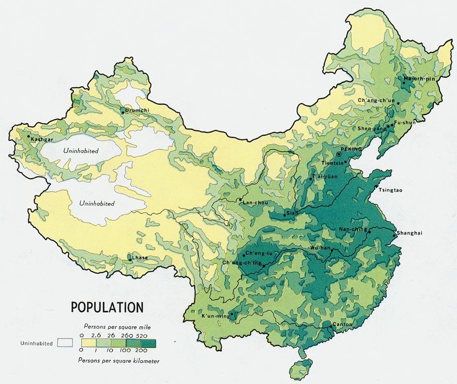
2 Mountains v Mountains are important in Asia because they influence: A. Population patterns B. Movement of people and goods C. Climate
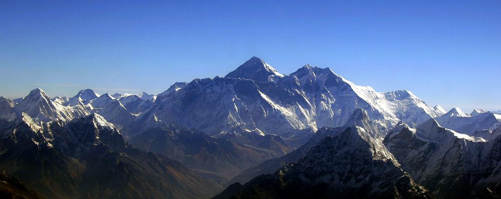
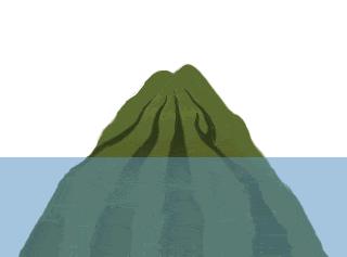
3 Mountains v The most important mountain range in Asia is the Himalaya Mountains. v The Himalayas separate India from China. v The Himalayas block clouds that are formed by monsoons from entering Western China. v The Himalayas isolate Tibet and make transportation difficult.
4
5
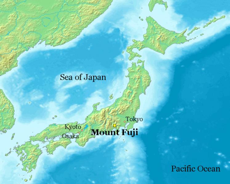
6 Mountains v Some other mountains in Asia are: A. The Hindu-Kush B. The Eastern and Western Ghats in India C. The Tian Shan Mountains D. Mount Fuji in Japan
7 Mountains v Mount Fuji is the tallest mountain in Japan at 12,388 ft. The mountain is located on the island of Honshu and it is considered sacred by Shintos.
8

9
10 Plateaus and Uplands v Most of Western China is on a plateau called the Plateau of Tibet. Farther north is the Mongolian Plateau. v The Korean Peninsula and the Japanese Islands are mountainous.
11 Rivers and Bodies of Water v Many rivers in Asia start in the Himalaya Mountains. v Rivers erode away the mountains and carry sediment (little bits of dirt) down to the flat plains at the base of the mountains. v The sediment makes the soil by the rivers fertile and a good place to farm.
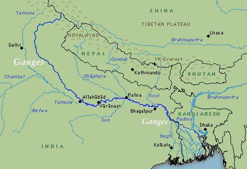
12 Rivers and Bodies of Water v The most important rivers in South Asia are: A. The Indus B. The Ganges C. The Brahmaputra
13 Rivers and Bodies of Water v The Ganges and Brahmaputra start in the Himalayas and flow into the Bay of Bengal. Both rivers flow through Bangladesh and as a result, this country often floods during the monsoon season.
14
15 The Ganges v The Ganges deposits sediment on a flat area called the Indo-Gangetic Plain. This river is important to India because it: A. Provides water for agriculture B. Provides water for factories and industries C. Provides water for human use D. Is considered sacred by Hindus
16 The Ganges v Hindus build temples on the banks of the Ganges River. One city, Varanasi, is considered sacred by Hindus and the focal point of pilgrimages. Hindus often pray in the water and when they die many are cremated and the ashes cast into the river.

17 Varanasi on the Ganges River
18 The Ganges v The Ganges River has become one of the most polluted rivers in the world due to: A. Pesticides and fertilizers that spill into the river. B. Chemicals and metals from factories. C. Raw sewage D. Human use
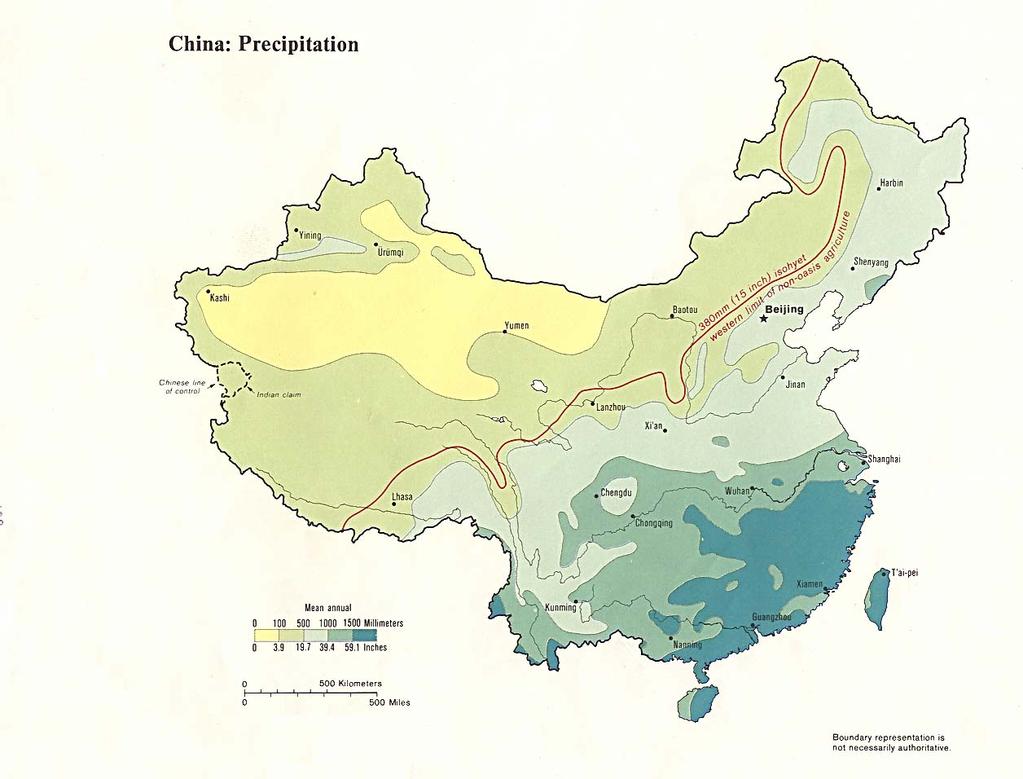
19 The Rivers of China v China has three major rivers that begin in the Himalayas and flow into the East China Sea or Yellow Sea. River Yellow River Yangtze River West River Chinese Name Huang He Chang Jiang Xi Jiang
20 The Rivers of China v The Yangtze and Yellow Rivers flow through an area that is flat in elevation called the North China Plain. This area has intensive farming and the two rivers are connected by The Grand Canal. The type of dirt found here is called loess. It is a rich soil that is yellow in color and normally deposited by the wind.

21 The Yellow River

22 The Yellow River
23 The Rivers of China v The Amur River starts in the Great Khingan Mountains in Northern China and empties into the Sea of Japan. This river is also a border between China and Russia.
24 Rivers in Southeast Asia v The longest river in Southeast Asia is the Mekong River. This river starts in the Himalayas and flows through China, Laos, Cambodia, and Vietnam before emptying into the South China Sea.
25 Bodies of Water v Asia is surrounded by bodies of water. One important body of water is the Sea of Japan. It is located between the Korean Peninsula and Japan. In Korea they refer to it as the East Sea.
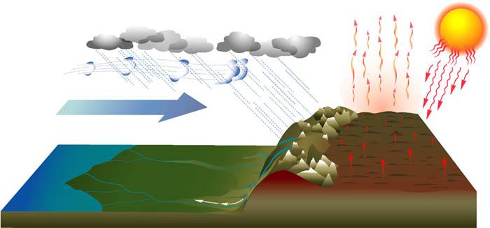
26 The Gobi Desert v The largest desert in this area is the Gobi Desert. v The Gobi Desert is formed by orographic precipitation. South Asia gets rain from the monsoons but the Himalaya Mountains block the rain from entering Western China. Most of Western China and Mongolia are in a rain shadow.
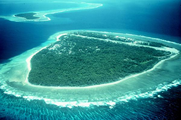
27 Islands v A group of islands is called an archipelago. There are many archipelagoes in Asia such as: A. Japan B. Philippines C. Indonesia D. Maldives
28 Maldives v The Maldives are located off of the southwest coast of India in the Indian Ocean. There are over 1200 small islands in the archipelago. The islands are atolls, the tops of submerged volcanoes surrounded by coral reefs.
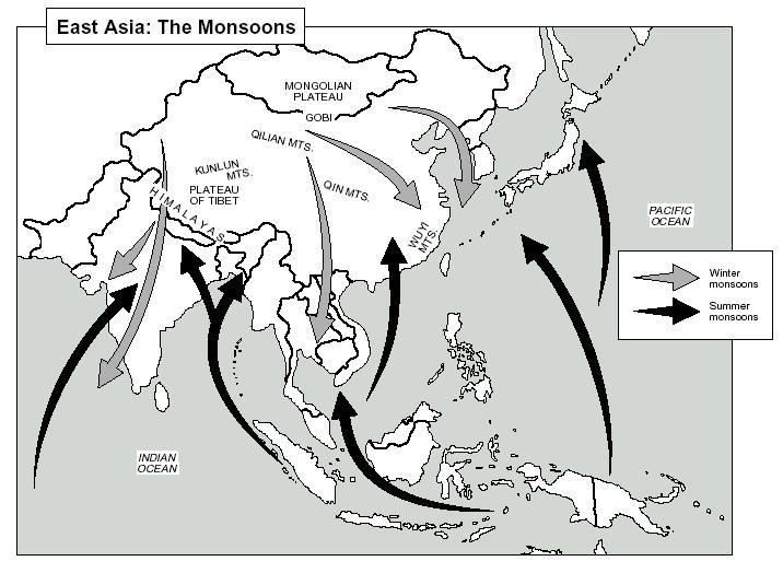
29
30
31 Other Islands v Some other islands in Asia are: A. Hainan B. Taiwan C. Sri Lanka D. Singapore E. Hong Kong
32 Taiwan v Taiwan is a large island off of the coast of China. Taiwan used to be called Formosa by the Portuguese. v The Democratic Republic of China is a country that is on the island. Some people just call the country Taiwan in order to avoid confusion.
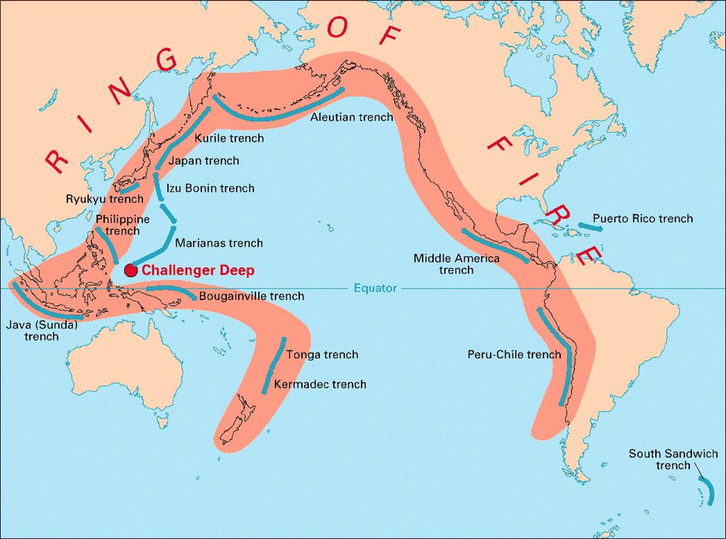
33 Singapore v Singapore is an island at the tip of the Malay Peninsula. The country of Singapore is located on the island and it has become very wealthy because it is on a strategic waterway, The Strait of Malacca.
34 Hong Kong v Hong Kong is an island off of the coast of China. It was ruled by the British but now it is part of China.
35 Natural Hazards v The natural hazards that are found in Asia are: A. Monsoons B. Typhoons (Cyclones) C. Volcanoes and Earthquakes
36 Monsoon v A monsoon is a seasonal wind that occurs in South and Southeast Asia. During the summer monsoon wind blows from south to north. The wind pushes clouds over South and Southeast Asia causing rain.
37
38
39 Typhoon v Typhoons or cyclones are tropical storms that occur in the Pacific Ocean. In the northern hemisphere they rotate counter clockwise. In the southern hemisphere they rotate clockwise. These storms cause enormous damage in coastal areas and countries with low elevations.
40 Ring of Fire v Part of Asia is on The Ring of Fire, an area around the Pacific Ocean where many tectonic plates meet. This area is at a greater risk for having earthquakes and active volcanoes.
41
42 Climate and Vegetation v Asia has varied climate regions because: A. Zones of latitude - Part of Asia is in the low latitudes and part of it is in the middle latitudes. B. Elevation - Mountainous regions in Asia have colder climates. C. Topography - Mountains block rainfall causing deserts on one side.
43 Climate and Vegetation v Part of Asia is in the low latitudes otherwise known as the tropics. These areas have tropical wet or tropical wet and dry climates. What countries are in this area? A. Southern part of India and Bangladesh B. Myanmar, Thailand, Laos, Cambodia, Vietnam C. Indonesia, Malaysia, Singapore, Philippines
44 Climate and Vegetation v Tropical wet climate zones always have tropical rainforests. One problem in many parts of Asia is deforestation.
45 Climate and Vegetation v China, Korea, Japan, Taiwan, and parts of India are in the middle latitudes. Many of these areas have a humid sub-tropical or humid continental climate. Most of Western China is a desert.
46
47 Climate and Vegetation v Most of Northern Japan has a humid continental climate zone. This climate zone can also be found in Maine and New Hampshire. The winters are cold and it snows.
48 Climate and Vegetation v Part of Mongolia is a desert and part of it is covered by steppe.
East Asia. Mongolia, China, Taiwan, the Koreas, and Japan
 East Asia Mongolia, China, Taiwan, the Koreas, and Japan Major Geographic Characteristics of East Asia East Asia is the most populous region in the world China is the most populous country, and the oldest
Chapter 21 Southwest Asia: Harsh & Arid Lands
 Name Hour Chapter 21 Southwest Asia: Harsh & Arid Lands Essential Question: How has the physical geography of Asia influenced the development of these regions (i.e. history, population distribution, &
The Impact of Geography in South and East Asia
 The Impact of Geography in South and East Asia Gobi desert, Mongolia Essential Question: How does geography impact the distribution of population throughout South and East Asia? I CAN Explain how geography
The Impact of Geography in South and East Asia
 The Impact of Geography in South and East Asia Gobi desert, Mongolia Essential Question: How does the geography of SE Asia impact trade and the distribution of population throughout the region? (AKS #52a)
Physical Geography of East Asia
 Physical Geography of East Asia Satellite View of China Landforms of China China s Geography China Miles 0 250 500 1,000 1,500 2,000 United States 3 rd largest country in the world. Comparable to the US
The Impact of Geography in South and East Asia
 The Impact of Geography in South and East Asia Gobi desert, Mongolia Essential Question: How does the geography of SE Asia impact trade and the distribution of population throughout the region? (AKS #52a)
UNIT 11 SOUTH ASIA SG 1 - PHYSICAL GEOGRAPHY & THE ENVIRONMENT
 UNIT 11 SOUTH ASIA SG 1 - PHYSICAL GEOGRAPHY & THE ENVIRONMENT I. PHYSICAL GEOGRAPHY TAKE OUT YOUR PHYSICAL MAP OF SOUTH ASIA A. The Himalayan Mountains form the northern boundary of the region (color
Thursday, April 27, 17
 Thursday, April 27, 17 Geography of Southeast Asia Objec-ve: Understand the geographical differences between the mainland region and the insular region of Southeast Asia. Do Now: What is the capital of
Physical Geography. Ariel view of the Amazon Rainforest. A Look at the Seven Continents
 Physical Geography In this unit you will learn about general physical geography. The study of the Earth s surface features provides the setting for the human-environmental interactions and for the human
Natural Disasters in Member Countries (2002 Summary)
") 4.2 Member Countries and their Disaster Characteristics: Table 5: Natural Disasters in Member Countries (2002 Summary) (Country/Disaster Type/Disaster Characteristics) Data Country DisType Count of TotAff
4.2 Member Countries and their Disaster Characteristics: Table 5: Natural Disasters in Member Countries (2002 Summary) (Country/Disaster Type/Disaster Characteristics) Data Country DisType Count of TotAff
Sec$on 1: Geography and Early China. How does China s geography affect the culture?
 Sec$on 1: Geography and Early China How does China s geography affect the culture? Con$nents of the World Label the continents. Where is China located? Where is China located? In your groups, begin filling
Tropical Moist Rainforest
 Tropical or Lowlatitude Climates: Controlled by equatorial tropical air masses Tropical Moist Rainforest Rainfall is heavy in all months - more than 250 cm. (100 in.). Common temperatures of 27 C (80 F)
Mount Everest and the Gobi Desert
 Mount Everest and the Gobi Desert 1 Mount Everest is part of the mountain chain known as the Himalaya. Adventurers from all over the world come to try to climb it. Mount Everest is the highest mountain
Chapter 1 Section 2. Land, Water, and Climate
 Chapter 1 Section 2 Land, Water, and Climate Vocabulary 1. Landforms- natural features of the Earth s land surface 2. Elevation- height above sea level 3. Relief- changes in height 4. Core- most inner
OUR COUNTRY INDIA LOCATIONAL SETTING
 7 India is a country of vast geographical expanse. In the north, it is bound by the lofty Himalayas. The Arabian Sea in the west, the Bay of Bengal in the east and the Indian Ocean in the south, wash the
Preview: Making a Mental Map of the Region
 Preview: Making a Mental Map of the Region Look at the outline map of Monsoon Asia on the next page. Add a compass rose to the map, showing where north, south, east, and west are. Then draw or shade and
UPDATE OF REGIONAL WEATHER AND SMOKE HAZE (May 2017)
") UPDATE OF REGIONAL WEATHER AND SMOKE HAZE (May 2017) 1. Review of Regional Weather Conditions in April 2017 1.1 Inter monsoon conditions, characterised by afternoon showers and winds that are generally
UPDATE OF REGIONAL WEATHER AND SMOKE HAZE (May 2017) 1. Review of Regional Weather Conditions in April 2017 1.1 Inter monsoon conditions, characterised by afternoon showers and winds that are generally
UPDATE OF REGIONAL WEATHER AND SMOKE HAZE (September 2017)
") UPDATE OF REGIONAL WEATHER AND SMOKE HAZE (September 2017) 1. Review of Regional Weather Conditions in August 2017 1.1 Southwest Monsoon conditions continued to prevail in the region in August 2017. The
UPDATE OF REGIONAL WEATHER AND SMOKE HAZE (September 2017) 1. Review of Regional Weather Conditions in August 2017 1.1 Southwest Monsoon conditions continued to prevail in the region in August 2017. The
By Geri Flanary To accompany AP Human Geography: A Study Guide 3 rd edition By Ethel Wood
 Session 1 By Geri Flanary To accompany AP Human Geography: A Study Guide 3 rd edition By Ethel Wood WHAT IS DEMOGRAPHY? It is the scientific or statistical study of population. It comes from the Greek
UPDATE OF REGIONAL WEATHER AND SMOKE HAZE (February 2018)
") UPDATE OF REGIONAL WEATHER AND SMOKE HAZE (February 2018) 1. Review of Regional Weather Conditions for January 2018 1.1 The prevailing Northeast monsoon conditions over Southeast Asia strengthened in January
UPDATE OF REGIONAL WEATHER AND SMOKE HAZE (February 2018) 1. Review of Regional Weather Conditions for January 2018 1.1 The prevailing Northeast monsoon conditions over Southeast Asia strengthened in January
Monsoon Asia TCI5 561 GA_LM_07-1.eps Second Proof
 Monsoon Asia Preview Making a Mental Map of the Region Look at the outline map of Monsoon Asia on the opposite page. Add a compass rose to the map, showing where north, south, east, and west are. Then
September 14, 2013 Objective: How does geography impact history? What important features exist that have shaped societies?
 Lowenhaupt 1 September 14, 2013 Objective: How does geography impact history? What important features exist that have shaped societies? Warm-Up: In your binder, answer the following question: Imagine you
1 st Term Test 2014 Maris Stella College - Negombo. Geography
 Grade 9 1 st Term Test 2014 Maris Stella College - Negombo Geography 2 Hour Name(. Class ( No ( Use MCQ paper to answer Part 1. 1) What is the Blue Planet? i. Neptune iii. Uranus ii. Earth iv. Merury 2)
UPDATE OF REGIONAL WEATHER AND SMOKE HAZE November 2016
 UPDATE OF REGIONAL WEATHER AND SMOKE HAZE November 2016 1. Review of Regional Weather Conditions in November 2016 1.1 Southwest Monsoon conditions prevailed on most days in October 2016 and the winds were
Long-Term Trend of Summer Rainfall at Selected Stations in the Republic of Korea
 Long-Term Trend of Summer Rainfall at Selected Stations in the Republic of Korea Il-Kon Kim Professor, Department of Region Information Rafique Ahmed Professor, Geography and Earth Science Silla University
SMART NOTES ON INDIAN GEOGRAPHY - 1
 ON INDIAN GEOGRAPHY - 1 Point. Precise. Powerful. www.thesmartnotes.org ON INDIAN GEOGRAPHY - 1 To our Hardworking and persistence aspirants. Success is going from failure to failure without losing enthusiasm.
Chapter 2 Planet Earth
 Chapter 2 Planet Earth Section Notes Earth and the Sun s Energy Water on Earth The Land Close-up The Water Cycle World Almanac Major Eruptions in the Ring of Fire Quick Facts Chapter 2 Visual Summary Video
World geography 3200/3202 Unit 2 review
 World geography 3200/3202 Unit 2 review 1. Does this statement use the terms revolve & rotate correctly? "Saturn revolves on its axis while several moons rotate around it." 2. Does this statement use the
UPDATE OF REGIONAL WEATHER AND SMOKE HAZE (December 2017)
") UPDATE OF REGIONAL WEATHER AND SMOKE HAZE (December 2017) 1. Review of Regional Weather Conditions for November 2017 1.1 In November 2017, Southeast Asia experienced inter-monsoon conditions in the first
UPDATE OF REGIONAL WEATHER AND SMOKE HAZE (December 2017) 1. Review of Regional Weather Conditions for November 2017 1.1 In November 2017, Southeast Asia experienced inter-monsoon conditions in the first
Presentation Plus! Glencoe World Geography Copyright by The McGraw-Hill Companies, Inc. Developed by FSCreations, Inc., Cincinnati, Ohio 45202
 Presentation Plus! Glencoe World Geography Copyright by The McGraw-Hill Companies, Inc. Developed by FSCreations, Inc., Cincinnati, Ohio 45202 Send all inquiries to: GLENCOE DIVISION Glencoe/McGraw-Hill
7 December 2016 Tokyo Climate Center, Japan Meteorological Agency
 Summary of the 2016 Asian Summer Monsoon 7 December 2016 Tokyo Climate Center, Japan Meteorological Agency This report summarizes the characteristics of the surface climate and atmospheric/oceanographic
UPDATE OF REGIONAL WEATHER AND SMOKE HAZE December 2016
 UPDATE OF REGIONAL WEATHER AND SMOKE HAZE December 2016 1. Review of Regional Weather Conditions in November 2016 1.1 Inter monsoon conditions prevailed in the first half of November 2016. During this
Ganbat.B, Agro meteorology Section
 NATIONAL AGENCY FOR METEOROLOGY, HYDROLOGY AND ENVIRONMENT MONITORING OF MONGOLIA Ganbat.B, Agro meteorology Section OF INSTITUTE OF METEOROLOGY AND HYDROLOGY 2009 YEAR Location Climate Northern Asia,
forest tropical jungle swamp marsh prairie savanna pampas Different Ecosystems (rainforest)
") Different Ecosystems forest A region of land that is covered with many trees and shrubs. tropical jungle (rainforest) swamp A region with dense trees and a variety of plant life. It has a tropical climate.
Different Ecosystems forest A region of land that is covered with many trees and shrubs. tropical jungle (rainforest) swamp A region with dense trees and a variety of plant life. It has a tropical climate.
GEOGRAPHY. H.C.G. - Paper 2
 CLASS IX GEOGRAPHY H.C.G. - Paper 2 (Two hours) Answers to this Paper must be written on the answer sheet provided separately. You will not be allowed to write during the first 15 minutes. This time is
Exploring the Geography of West Asia
 Unit 3 - Lesson 1 Content Expectations 7 G1.1.1: Explain and use a variety of maps, globes, and web based geography technology to study the world, including global, interregional, regional, and local scales.
3) What is the difference between latitude and longitude and what is their affect on local and world weather and climate?
 What is the difference between latitude and longitude and what is their affect on local and world weather and climate?") www.discoveryeducation.com 1) Describe the difference between climate and weather citing an example of each. Describe how water (ocean, lake, river) has a local effect on weather and climate and provide
www.discoveryeducation.com 1) Describe the difference between climate and weather citing an example of each. Describe how water (ocean, lake, river) has a local effect on weather and climate and provide
ENVE203 Environmental Engineering Ecology (Oct 15, 2012)
") ENVE203 Environmental Engineering Ecology (Oct 15, 2012) Elif Soyer Ecosystem and Physical Environment Atmosphere, Ocean, Weather & Climate, Internal Planetary Processes Atmospheric Circulation Different
ENVE203 Environmental Engineering Ecology (Oct 15, 2012) Elif Soyer Ecosystem and Physical Environment Atmosphere, Ocean, Weather & Climate, Internal Planetary Processes Atmospheric Circulation Different
FLOODING. Flood any relatively high stream flow overtopping the natural or artificial banks in a water system.
 CATASTROPHIC EVENTS FLOODING Flood any relatively high stream flow overtopping the natural or artificial banks in a water system. Common Causes: Long-lasting rainfall over a broad area Locally intense
GLOBAL CLIMATES FOCUS
 which you will learn more about in Chapter 6. Refer to the climate map and chart on pages 28-29 as you read the rest of this chapter. FOCUS GLOBAL CLIMATES What are the major influences on climate? Where
Geography Class XI Fundamentals of Physical Geography Section A Total Periods : 140 Total Marks : 70. Periods Topic Subject Matter Geographical Skills
 Geography Class XI Fundamentals of Physical Geography Section A Total Periods : 140 Total Marks : 70 Sr. No. 01 Periods Topic Subject Matter Geographical Skills Nature and Scope Definition, nature, i)
KUALA LUMPUR MONSOON ACTIVITY CENT
 T KUALA LUMPUR MONSOON ACTIVITY CENT 2 ALAYSIAN METEOROLOGICAL http://www.met.gov.my DEPARTMENT MINISTRY OF SCIENCE. TECHNOLOGY AND INNOVATIO Introduction Atmospheric and oceanic conditions over the tropical
World Geography Chapter 3
 World Geography Chapter 3 Section 1 A. Introduction a. Weather b. Climate c. Both weather and climate are influenced by i. direct sunlight. ii. iii. iv. the features of the earth s surface. B. The Greenhouse
 Page 1 of 5 Home research global climate enso effects Research Effects of El Niño on world weather Precipitation Temperature Tropical Cyclones El Niño affects the weather in large parts of the world. The
Chapter 2: Physical Geography
 Chapter 2: Physical Geography Pg. 39-68 Learning Goals for Chp2: q q q q q Explain how the Earth moves in space and why seasons change. Outline the factors that influence climate and recognize different
Ancient China UNIT 4 GEOGRAPHY CHALLENGE. 1 Unit 4 Geography Challenge. Teachers Curriculum Institute
 UNIT 4 GEOGRAPHY CHALLENGE Ancient China N W E S 0 250 500 miles 0 250 500 kilometers Albers Conic Equal-Area Projection AW_ISN_U04_01 Ancient China Second Proof TCI18 108 1 Unit 4 Geography Challenge
Australia and New Zealand: Powerpoint
 Australia and New Zealand: Powerpoint Physical Geography Australia and New Zealand are between the Indian and Pacific Oceans. Australia s seasons are opposite of the United States due to their location.
UPDATE OF REGIONAL WEATHER AND SMOKE HAZE February 2016
 UPDATE OF REGIONAL WEATHER AND SMOKE HAZE February 2016 1. Review of Regional Weather Conditions in January 2016 1.1 The Northeast Monsoon conditions prevailed in the region in January 2016. With the monsoon
(version 3) I. HumAN -Environment Interaction
 I. HumAN -Environment Interaction") (version 3) I. HumAN -Environment Interaction A. Landforms 1. Earth s topography is made up of many different types of landforms. 2. While the planet is covered primarily with water, the four major types
(version 3) I. HumAN -Environment Interaction A. Landforms 1. Earth s topography is made up of many different types of landforms. 2. While the planet is covered primarily with water, the four major types
Iceland. 1. Warm up. A. Talk about the picture and read the essay. B. Discuss the questions about the essay.
 1. Warm up A. Talk about the picture and read the essay. Iceland My country, Iceland, is one of the most beautiful countries on Earth. It is an island country. It is located in Europe, in the North Atlantic
EQ: Discuss main geographic landforms of the U.S. & Canada and examine varied landforms in relation to their lifestyles.
 EQ: Discuss main geographic landforms of the U.S. & Canada and examine varied landforms in relation to their lifestyles. Places & Terms for Discussion Appalachian Mountains Great Plains Canadian Shield
Bell Work. REVIEW: Our Planet Earth Page 29 Document A & B Questions
 9.12.16 Bell Work REVIEW: Our Planet Earth Page 29 Document A & B Questions Intro to Climate & Weather https://www.youtube.com/watch?v=vhgyoa70q7y Weather vs. Climate Video Climate & Weather 3.1 Weather
The Indian Ocean. Copyright 2010 LessonSnips
 The Indian Ocean One of the five major geographic divisions of the world s ocean, the Indian Ocean is located in the Eastern Hemisphere. The Indian Ocean is bounded by three continents: Africa to the west,
CH. 3: Climate and Vegetation
 CH. 3: Climate and Vegetation GROUP WORK RUBRIC Score of 50 (5): Superior - 100% A 5 is superior work, and has completed all requirements of the assignments, it is in order and its presentation is almost
Ancient China. Teachers Curriculum Institute Geography and the Early Settlement of China 1. AW_ISN_U04_01 Ancient China Second Proof TCI18 108
 G e o g r a p h y C h a l l e n g e Ancient China N W E S 0 250 500 miles 0 250 500 kilometers Albers Conic Equal-Area Projection AW_ISN_U04_01 Ancient China Second Proof TCI18 108 Teachers Curriculum
netw rks Guided Reading Activity Essential Question: How does geography influence the way people live? Earth's Physical Geography
 Guided Reading Activity Lesson 1 Earth and the Sun Essential Question: How does geography influence the way people live? Looking at Earth Directions: What are the layers that make up Earth? Use your textbook
Cambridge International Examinations Cambridge International General Certificate of Secondary Education
 Cambridge International Examinations Cambridge International General Certificate of Secondary Education *4298138811* ENVIRONMENTAL MANAGEMENT 0680/23 Paper 2 October/November 2014 1 hour 45 minutes Candidates
Physical Geography. China, Mongolia, and Taiwan: Physical-Political. Define. Read to Discover. Locate. 1. What are the physical features.
 Physical Geography Read to Discover Define. 1. What are the physical features dikes Himalayas Gobi, arable -MOlln-t-E--Verest. North China Plain. Huang He of China, Mongolia, and Taiwan? Locate 2. What
Asia. JigsawGeo. Free Printable Maps for Geography Education. Try our geography games for the ipod Touch or iphone.
 Free Printable Maps for Geography Education Map with region names shown Map without names, for coloring or quizzes Map with coordinate system, for location practice Answer key for coordinate system quiz
Weather Atmospheric condition in one place during a limited period of time Climate Weather patterns that an area typically experiences over a long
 Weather Atmospheric condition in one place during a limited period of time Climate Weather patterns that an area typically experiences over a long period of time Many factors influence weather & climate
SIO15 Midterm 2, Wednesday Nov. 28, 2018
 SIO15 Midterm 2, Wednesday Nov. 28, 2018 TEST VARIATION: B 1) For what are flood frequency curves used? a) to predict the next rain storm b) to estimate the highest flood likely in a 100-year interval
Unit 1 Test - Version A
 Unit 1 Test - Version A 1. Approximately, how many degrees of longitude equal one time zone change? a. 5 b. 10 c. 15 d. 20 e. 25 2. The city of Lewisville has a population of 1,000 people living in 100
What is the largest country in the world? Russia
 What is the largest country in the world? #1 Russia CSCOPE 2007 2 Russia Dimensions #2-3 Spans 11 Time Zones From East to West: Gulf of Finland to Alaska From North to South: Above the Arctic Circle to
Guided Reading Activity
 Guided Reading Activity Lesson 1 Physical Features Essential Question: How does geography influence the way people live? A Vast Land Directions: Read the lesson and use your text to decide whether each
Chapter 24 Test on Southeast Asia
 Name Score Chapter 24 Test on Southeast Asia Part 1 - Multiple Choice (24 pts.) Read the following statements carefully. Select and circle the most correct choice from among the choices provided. 1. Which
2. PHYSICAL FEATURES OF INDIA
 2. PHYSICAL FEATURES OF INDIA Question 1: Choose the right answer from the four alternatives given below. (i) A landmass bound by sea on three sides is referred to as (a) Coast (c) Peninsula (b) Island
1 What Is Climate? TAKE A LOOK 2. Explain Why do areas near the equator tend to have high temperatures?
 CHAPTER 17 1 What Is Climate? SECTION Climate BEFORE YOU READ After you read this section, you should be able to answer these questions: What is climate? What factors affect climate? How do climates differ
Global Weather Trade Winds etc.notebook February 17, 2017
 Global Weather 1 north pole northern hemisphere equator southern hemisphere south pole 2 We have seasons because of the Earth's tilt The seasons are opposite in the northern and southern hemispheres winter
UNIVERSITY OF CAMBRIDGE INTERNATIONAL EXAMINATIONS International General Certificate of Secondary Education
 UNIVERSITY OF CAMBRIDGE INTERNATIONAL EXAMINATIONS International General Certificate of Secondary Education *9231176876* GEOGRAPHY 0460/12 Paper 1 May/June 2013 Candidates answer on the Question Paper.
Chapter 1 Study Guide
 Chapter 1 Study Guide Reminders: Vocabulary quiz and test will be on Tuesday, September 6th. Complete study guide and bring completed to school Friday, September 2nd. You are NOT required to print the
Downloaded from
 I II III IV V VI Define the following terms:- a) Orbitb) Meteoroids c) Celestial bodies GEOGRAPHY ASSIGNMENTS The Earth In The Solar System d) Satellite e) Comets Give one word answers:- a) Blue planet
Social Studies. Chapter 2 Canada s Physical Landscape
 Social Studies Chapter 2 Canada s Physical Landscape Introduction Canada s geography its landforms and climate - has a great impact on Canadians sense of identity. Planet Earth The earth is divided into
Dr. M.K.K. Arya Model School Class-V, Social Science Assignment Ch-1, Globe The Model of the Earth Answer the following:- Q.1.
 Class-V, Social Science Assignment Ch-1, Globe The Model of the Earth - Q.1. What are the disadvantages/demerits of a globe? Ans. Some disadvantages of globe are: a) It is difficult to carry. b) It cannot
CropCast Weekly Rice Report Don Keeney Wednesday, May 31, 2017
 Global Rice Summary 17/18 Production Estimate: 489.54 MMT Rains in northern Vietnam this week should improve moisture for rice. Abundant rains Thailand are maintaining favorable moisture. Widespread rains
Word Cards. 2 map. 1 geographic representation. a description or portrayal of the Earth or parts of the Earth. a visual representation of an area
 Name: Date: Hour: Word Cards 1 geographic representation a description or portrayal of the Earth or parts of the Earth Example: A map is a representation of an actual location or place. 2 map a visual
The structure of the Earth and how its motion creates the seasons. The landforms of the earth and the forces that shape the land.
 The structure of the Earth and how its motion creates the seasons. The landforms of the earth and the forces that shape the land. The role of wind and water in creating climate. The different climate and
Unit 1: Basics of Geography Test Review
 Name Date Period Unit 1: Basics of Geography Test Review Directions: Reading the following sections and complete the questions, charts, and diagrams. Types of Maps Maps that have a particular theme are
Weather & Ocean Currents
 Weather & Ocean Currents Earth is heated unevenly Causes: Earth is round Earth is tilted on an axis Earth s orbit is eliptical Effects: Convection = vertical circular currents caused by temperature differences
Verification of the Seasonal Forecast for the 2005/06 Winter
 Verification of the Seasonal Forecast for the 2005/06 Winter Shingo Yamada Tokyo Climate Center Japan Meteorological Agency 2006/11/02 7 th Joint Meeting on EAWM Contents 1. Verification of the Seasonal
WHAT CAN MAPS TELL US ABOUT THE GEOGRAPHY OF ANCIENT GREECE? MAP TYPE 1: CLIMATE MAPS
 WHAT CAN MAPS TELL US ABOUT THE GEOGRAPHY OF ANCIENT GREECE? MAP TYPE 1: CLIMATE MAPS MAP TYPE 2: PHYSICAL AND/OR TOPOGRAPHICAL MAPS MAP TYPE 3: POLITICAL MAPS TYPE 4: RESOURCE & TRADE MAPS Descriptions
Cement and clinker trade flows in Asia. Ad Ligthart Cement Distribution Consultants
 Cement and clinker trade flows in Asia Ad Ligthart Cement Distribution Consultants 19 June 2012 General overview Region includes Indian Ocean and Pacific Ocean islands (excl. Hawaii) Global cement and
Chapter 3: Study Guide
 Chapter 3: Study Guide Multiple Choice 1. Places located in high latitudes have a. a very warm climate. b. the same weather as places in other latitudes. c. a mix of extremely hot and extremely cold weather.
Map Skills Test. 1. What do we call a person who makes maps? a. mapographer b. cartographer c. geologist d. archaeologist
 Map Skills Test 1. What do we call a person who makes maps? a. mapographer b. cartographer c. geologist d. archaeologist 2. What is the name of the 0 latitude line? a. Equator b. Arctic Circle c. First
Weather Atmospheric condition in one place during a limited period of time Climate Weather patterns that an area typically experiences over a long
 Weather Atmospheric condition in one place during a limited period of time Climate Weather patterns that an area typically experiences over a long period of time Many factors influence weather & climate
Grade 9 Social Studies Canadian Identity. Chapter 2 Review Canada s Physical Landscape
 Grade 9 Social Studies Canadian Identity Chapter 2 Review Canada s Physical Landscape Name: Unit 1: Empowerment Terms (notes or textbook) 1. Core 2. Crust 3. Mantle 4. Magma 5. Continental drift 6. Plate
Unit 1: Geography. For additional information, refer to this website: 1 G e o g r a p h y
 Unit 1: Geography For additional information, refer to this website: http://mryoungtms.weebly.com/ 1 G e o g r a p h y Continents and Oceans SOL USI. 2a Essential Understanding: Continents are large land
Unit 2. United States Physical Geography
 Unit 2 United States Physical Geography Physical Geography U.S. extends from the Atlantic to Pacific U.S. is the 3rd largest country U.S. has fertile soils, vast forests, and variety of minerals All major
GIRLS SECON DARY - MRIEĦEL HALF-YEARLY EXAMINATIONS 2016/2017
 GIRLS SECON DARY - MRIEĦEL HALF-YEARLY EXAMINATIONS 2016/2017 FORM: 4 Time: 1 ½ hrs Name: Class: Section A: Weather and Climate 1. Place the following weather conditions under the appropriate heading.
Wind: Global Systems Chapter 10
 Wind: Global Systems Chapter 10 General Circulation of the Atmosphere General circulation of the atmosphere describes average wind patterns and is useful for understanding climate Over the earth, incoming
Formative Test. 4 th Grading in Science VII
 Formative Test 4 th Grading in Science VII I. Latitude and Longitude 1. It is an imaginary line that divides the northern and southern hemispheres. A. Latitude B. Equator C. Longitude D. Tropic of Cancer
About places and/or important events Landmarks Maps How the land is, hills or flat or mountain range Connected to maps World Different countries
 What do you think you know about geography? About places and/or important events Landmarks Maps How the land is, hills or flat or mountain range Connected to maps World Different countries What do you
STUDY GUIDE. The Land. Physical Features. Australia. Oceania. Chapter 32, Section 1. New Zealand Antarctica. Terms to Know DRAWING FROM EXPERIENCE
 For use with textbook pages 793 798. The Land Terms to Know artesian well A well from which pressurized water flows to the surface (page 794) coral The limestone skeletons of tiny sea animals (page 795)
A Questionnaire on the Utilization of Satellite Data from the New Generation of Geostationary Meteorological Satellites
 3.1 User requirements for satellite data utilization, especially for new-generation satellites A Questionnaire on the Utilization of Satellite Data from the New Generation of Geostationary Meteorological
Year 4 Geography Revision Pack Summer 2018 Name
 Year 4 Geography Revision Pack Summer 2018 Name Welcome to your geography revision pack for the upcoming Summer exams. Everything that we have been working on in lessons since Christmas will be covered
Shuhei Maeda Climate Prediction Division Global Environment and Marine Department Japan Meteorological Agency
 Eighth Session of the Forum on Regional Climate Monitoring, Assessment and Prediction for Asia (FOCRAII) 5-7 April 2012, Beijing, China Shuhei Maeda Climate Prediction Division Global Environment and Marine
Keys to Climate Climate Classification Low Latitude Climates Midlatitude Climates High Latitude Climates Highland Climates Our Changing Climate
 Climate Global Climates Keys to Climate Climate Classification Low Latitude Climates Midlatitude Climates High Latitude Climates Highland Climates Our Changing Climate Keys to Climate Climate the average
Summative Assessment I
 Class: IV Time: 3 Hrs. Summative Assessment I Social Science Marks: 88 Handwriting: 2 Total: 90 1. All questions are compulsory. 2. Use crayons for colouring. General Instruction I. Multiple choice questions:
4 Changes in Climate. TAKE A LOOK 2. Explain Why is more land exposed during glacial periods than at other times?
 Name Class CHAPTER 3 Date Climate 4 Changes in Climate SECTION National Science Education Standards BEFORE YOU READ After you read this section, you should be able to answer these questions: ES 1k, 2a
Grade 9 Geography Chapter 11 - Climate Connections
 Grade 9 Geography Chapter 11 - Climate Connections 1. Define: Weather. 2. In what way has weather affected your activities in the last two weeks? 3. Define: Climate. 4. Canada s climate is a function of