THE FIRST EXPERIENCE OF USING ALOS DATA FOR DISASTER MONITORING
|
|
|
- Hannah Nichols
- 5 years ago
- Views:
Transcription
1 THE FIRST EXPERIENCE OF USING ALOS DATA FOR DISASTER MONITORING Dr. Nguyen Dinh Duong, IG, VAST Dr. Nguyen Xuan Lam, RSC, MONRE Dr. Hoang Minh Hien,, DMU, MARD
2 Contents The Xangsane Typhoon Acquisition of ALOS Data Some information about Xangsane Typhoon interpreted from ALOS Data Conclusion and Recommendation
3 The Xangsane Typhoon Formed on Sep. 26 th, 2006 in the ocean east of Philippine After passing Philippine, the Xangsane hit Danang City on Oct. 1 st, The Xangsane was recognized as one of the most violent in the past two decades. The wind reached Beaufort scale 12 (130km/h), gusting above scale 13 ( km/h)
4 69 dead and 525 injured Total economic loss: about 10,376 billions VND
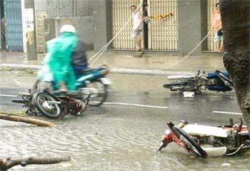


5
6 Acquisition of ALOS Data Request on ALOS emergency observation was sent to ADRC on Oct. 2. Response from JAXA DMSSO about emergency observation on Oct. 3. Emergency observation was taken at 10am, Oct. 4 over Danang City area by two sensors: AVNIR-2 2 and PALSAR
7 List of ALOS data AVNIR-2 A URGN0003-AODS A URGN0003-AODS A URGN0003-AODS A URGN0003-AODS PALSAR A URGN0003-AODS A URGN0003-AODS A URGN0003-AODS A URGN0003-AODS


8 AVNIR-2 2 Images


9 PALSAR Images
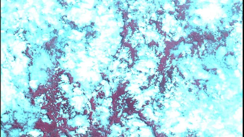
10 Data Analysis The AVNIR-2 2 images were not used due to heavy cloudiness There was no observation before typhoon An ADEOS AVNIR scene of Da Nang City taken on Apr. 18, 1997 was used for comparison study Inundated area extraction was carried out

11 ADEOS AVNIR Apr. 18, 1997 over Danang City


12 Comparison between ADEOS AVNIR (left) and ALOS PALSAR (right)


13 Inundated area extraction

14 Inundated area extraction

15 Inundated area extraction
16 Discussion Emergency observation is important for disaster management In some cases due to heavy cloudiness the optical data is less useful Multipolarized microwave data seems to be the best data source for typhoon and flood disasters
17 JAXA provided data through internet environment, time needed for downloading data depends on network environment (in case of Vietnam it took 8 hours to download 4 AVNIR-2 2 and 4 PALSAR scenes)
18 For practical use, there is requirement to develop standard products with standard processing flow for disaster management purpose. Level 1 data is still difficult for direct use. There are many geometric distortion
19 Question is how to make fast geo- reference of RS data in order to be combined with other GIS data Accuracy of geo-referencing does not need to be on high level For making the first report on disaster the following spatial data should be ready:
20 Population and administrative boundaries Road network and other infrastructure facilities DEM Geometrically corrected ALOS data before and after disaster
21 The first standard products for disaster consequence analysis: Change of vegetation index (optical data) Change of structure coefficients (optical data) Change of back scattering (microwave data) Damage level assessment Inundation level warning River or other water body overflow status
22 Making report in form of digital maps and text: targeting on qualitative assessment The first report should be generated 24 hours after observation and broadcasted on TV, radio as well as sent to the local government. My concept is: data for professionals and scientists, information for managers and public
23 Recommendation SA is composed of four components: Int. com., Space com., DRC, DA. It is useful to add in-country components which has at least two members: one from disaster management and the other from technical organization who is able to process satellite data. This component will ensure better implementation of SA.
24 Thank you for your attention
Recent development of the National Hydro-Meteorological Service (NHMS) of Viet Nam for disaster risk reduction
 of Viet Nam for disaster risk reduction") Ministry of Natural Resources and Environment National Hydro-Meteorological Service Recent development of the National Hydro-Meteorological Service (NHMS) of Viet Nam for disaster risk reduction Tran Van
Ministry of Natural Resources and Environment National Hydro-Meteorological Service Recent development of the National Hydro-Meteorological Service (NHMS) of Viet Nam for disaster risk reduction Tran Van
AND THE COOPERATION WITH SENTINEL ASIA FOR DISASTER MANAGEMENT
 Ministry of Natural resources and Environment National Remote Sensing DEpartment NATIONAL REMOTE SENSING DEPARTMENT (NRSD) AND THE COOPERATION WITH SENTINEL ASIA FOR DISASTER MANAGEMENT By: Dr. Chu Hai
Sentinel Asia System Operation for Disaster Management in Sri Lanka Major General L.B.R. Mark (Retd) Director General Disaster Management Centre
 Director General Disaster Management Centre") Sentinel Asia System Operation for Disaster Management in Sri Lanka Major General L.B.R. Mark (Retd) Director General Disaster Management Centre Government of Sri Lanka OUTLINE Background Disasters in
Sentinel Asia System Operation for Disaster Management in Sri Lanka Major General L.B.R. Mark (Retd) Director General Disaster Management Centre Government of Sri Lanka OUTLINE Background Disasters in
Capacity Building in Applications of Remote Sensing and GIS for Disaster Management
 Capacity Building in Applications of Remote Sensing and GIS for Disaster Management M.K. Hazarika, L. Samarakoon, N. Senevirathne, J.S.M. Fowze and R. de Silva Project Researcher GeoInformatics Center
Establishment of WINDS Ground Station in Sri Lanka. By G.K.D. Amarawardena Additional Secretary Ministry of Disaster Management Sri Lanka
 Establishment of WINDS Ground Station in Sri Lanka By G.K.D. Amarawardena Additional Secretary Ministry of Disaster Management Sri Lanka Contents Background SAS Implementation Progress of WINDS establishment
EXTRACTION OF FLOODED AREAS DUE THE 2015 KANTO-TOHOKU HEAVY RAINFALL IN JAPAN USING PALSAR-2 IMAGES
 EXTRACTION OF FLOODED AREAS DUE THE 2015 KANTO-TOHOKU HEAVY RAINFALL IN JAPAN USING PALSAR-2 IMAGES F. Yamazaki a, *, W. Liu a a Chiba University, Graduate School of Engineering, Chiba 263-8522, Japan
VNREDSat-1. Vietnam Natural Resources, Environment and Disaster monitoring Satellite. Lai Anh Khoi SPACE TECHNOLOGY INSTITUTE
 VNREDSat-1 Vietnam Natural Resources, Environment and Disaster monitoring Satellite Lai Anh Khoi SPACE TECHNOLOGY INSTITUTE JPTM2014 Yangon, Nov. 19-21, 2014 General information (1) Project Owner: Vietnam
Utilization of Satellite for Disaster Management with a Focus on the Sentinel Asia
 2013/01/23 Asian Conference on Reduction 2013 Utilization of Satellite for Management with a Focus on the Sentinel Asia Ichiro NAITO JAXA Space Applications and Promotion Center Management Support Systems
2014 Summer training course for slope land disaster reduction Taipei, Taiwan, Aug
 MINISTRY OF SCIENCE AND TECHNOLOGY HYDROTECH RESEARCH INSTITUTE MINISTRY OF NATURAL RESOURCES AND ENVIRONMENT VIETNAM INSTITUTE OF GEOSCIENCES AND MINERAL RESOURCES (VIGMR) 2014 Summer training course
Development of Tropical Storm Falcon (Meari) over the Philippines
 over the Philippines") Development of Tropical Storm Falcon (Meari) over the Philippines June 20-27, 2011 At the end of June, 2011, the Philippines were struck again by Tropical storm Falcon (Meari). After gaining strength over
Development of Tropical Storm Falcon (Meari) over the Philippines June 20-27, 2011 At the end of June, 2011, the Philippines were struck again by Tropical storm Falcon (Meari). After gaining strength over
Sentinel Asia Tsunami Working Group
 Sentinel Asia Tsunami Working Group Co-Chairman: Prof. Shunichi Koshimura Abdul Muhari, PhD 4 th Joint Project Team Meeting (JPTM 2017): Sentinel Asia STEP 3 Abdul MUHARI, PhD Ministry of Marine Affairs
Effective Utilization of Synthetic Aperture Radar (SAR) Imagery in Rapid Damage Assessment
 Imagery in Rapid Damage Assessment") Effective Utilization of Synthetic Aperture Radar (SAR) Imagery in Rapid Damage Assessment Case Study Pakistan Floods SUPARCO M. Maisam Raza, Ahmad H. Rabbani SEQUENCE Flood Monitoring using Satellite
Effective Utilization of Synthetic Aperture Radar (SAR) Imagery in Rapid Damage Assessment Case Study Pakistan Floods SUPARCO M. Maisam Raza, Ahmad H. Rabbani SEQUENCE Flood Monitoring using Satellite
March 2007 The Survey Department of Sri Lanka
 Contribution of Survey Department of Sri Lanka for Mitigation of Disasters in Sri Lanka K.A.U.N.Kasthuri Deputy Surveyor General (Information Technology) March 2007 The Survey Department of Sri Lanka 1
Japanese Programs on Space and Water Applications
 Japanese Programs on Space and Water Applications Tamotsu IGARASHI Remote Sensing Technology Center of Japan June 2006 COPUOS 2006 Vienna International Centre Water-related hazards/disasters may occur
INTRODUCTION OF A SUCCESS STORY IN THE PHILIPPINES
 INTRODUCTION OF A SUCCESS STORY IN THE PHILIPPINES Arturo S. Daag Department of Science and Technology Philippine Institute of Volcanology and Seismology (DOST-PHIVOLCS) Establishment of Sentinel Asia
THE STUDY ON 4S TECHNOLOGY IN THE COMMAND OF EARTHQUAKE DISASTER EMERGENCY 1
 THE STUDY ON 4S TECHNOLOGY IN THE COMMAND OF EARTHQUAKE DISASTER EMERGENCY 1 Zhou Wensheng 1, Huang Jianxi 2, Li Qiang 3, Liu Ze 3 1 Associate Professor, School of Architecture, Tsinghua University, Beijing.
Global Flood Alert System based on satellite derived rainfall data -Targeting the era of Global Precipitation Measurement (GPM)-
-") Global Flood Alert System based on satellite derived rainfall data -Targeting the era of Global Precipitation Measurement (GPM)- Riko Oki, Misako Kachi (JAXA/EORC) Kazuhiko Fukami (PWRI) and Kazuo Umeda
Global Flood Alert System based on satellite derived rainfall data -Targeting the era of Global Precipitation Measurement (GPM)- Riko Oki, Misako Kachi (JAXA/EORC) Kazuhiko Fukami (PWRI) and Kazuo Umeda
International Symposium on Natural Disaster Mitigation. Local vulnerability assessment of landslides and debris flows
 International Symposium on Natural Disaster Mitigation of landslides and debris flows Lessons learnt from Cam Pha town and Van Don district, Quang Ninh province, Vietnam Nguyen Quoc Phi Faculty of Environment
Sentinel Asia Data Provider Node Report
 Sentinel Asia Data Provider Node Report Joint Project Team Meeting for Sentinel Asia STEP3 (JPTM2018) 23 24 January 2018, Taipei, Taiwan Yuji TAKADA Space Applications and Operations Center (SAOC) Japan
Application of Satellite Data for Flood Forecasting and Early Warning in the Mekong River Basin in South-east Asia
 MEKONG RIVER COMMISSION Vientiane, Lao PDR Application of Satellite Data for Flood Forecasting and Early Warning in the Mekong River Basin in South-east Asia 4 th World Water Forum March 2006 Mexico City,
Implementation Status & Results Vietnam Danang Sustainable City Development Project (SCDP) (P123384)
 (P123384)") Public Disclosure Authorized Public Disclosure Authorized The World Bank Implementation Status & Results Vietnam Danang Sustainable City Development Project (SCDP) (P123384) Operation Name: Danang Sustainable
Public Disclosure Authorized Public Disclosure Authorized The World Bank Implementation Status & Results Vietnam Danang Sustainable City Development Project (SCDP) (P123384) Operation Name: Danang Sustainable
HEAVY RAIN OVER MID-CENTRAL REGION OF VIETNAM
 HEAVY RAIN OVER MID-CENTRAL REGION OF VIETNAM ----------------------------------------------------------------------- S.Eng. Dang Thi Mai; Dr. Nguyen Thi Tan Thanh National Hydro Meteorological Service
Utilization of Global Map for Societal Benefit Areas
 Utilization of Global Map for Societal Benefit Areas The Fourth GEOSS AP Symposium Bali Indonesia, 11th March 2010 Shuhei Kojima Geographical Survey Institute Ministry of Land, Infrastructure, Transport
FLOOD DAMAGE ASSESSMENT INTEGRATING GEOSPATIAL TECHNOLOGIES. A CASE STUDY IN HUE, VIET NAM
 Paper 5-4-2 FLOOD DAMAGE ASSESSMENT INTEGRATING GEOSPATIAL TECHNOLOGIES. A CASE STUDY IN HUE, VIET NAM DINH NGOC DAT, J. S. M. FOWZE, NGUYEN DUONG ANH, MANZUL K. HAZARIKA AND LAL SAMARAKOON GeoInformatics
GENERAL. CHAPTER 1 BACKGROUND AND PURPOSE OF THE GUIDELINES Background of the Guidelines Purpose of the Guidelines...
 GENERAL CHAPTER 1 BACKGROUND AND PURPOSE OF THE GUIDELINES... 1 1.1 Background of the Guidelines... 1 1.2 Purpose of the Guidelines... 3 CHAPTER 2 APPLICATION OF THE GUIDELINES... 3 2.1 Potential Users
10 emergency observation requests were successfully processed during the period
 ISRO s Inputs for the Sentinel Asia DPN and JPT meeting being held during 13-16, 16, November 2012 November 2012 Sentinel Asia Activity Spectrum - A dedicated Sentinel Asia server established at NRSC,
THE 3D SIMULATION INFORMATION SYSTEM FOR ASSESSING THE FLOODING LOST IN KEELUNG RIVER BASIN
 THE 3D SIMULATION INFORMATION SYSTEM FOR ASSESSING THE FLOODING LOST IN KEELUNG RIVER BASIN Kuo-Chung Wen *, Tsung-Hsing Huang ** * Associate Professor, Chinese Culture University, Taipei **Master, Chinese
Natural Disasters in Member Countries (2002 Summary)
") 4.2 Member Countries and their Disaster Characteristics: Table 5: Natural Disasters in Member Countries (2002 Summary) (Country/Disaster Type/Disaster Characteristics) Data Country DisType Count of TotAff
4.2 Member Countries and their Disaster Characteristics: Table 5: Natural Disasters in Member Countries (2002 Summary) (Country/Disaster Type/Disaster Characteristics) Data Country DisType Count of TotAff
(Refer Slide Time: 3:48)
") Introduction to Remote Sensing Dr. Arun K Saraf Department of Earth Sciences Indian Institute of Technology Roorkee Lecture 01 What is Satellite based Remote Sensing Hello, hello everyone this is Arun
Introduction to Remote Sensing Dr. Arun K Saraf Department of Earth Sciences Indian Institute of Technology Roorkee Lecture 01 What is Satellite based Remote Sensing Hello, hello everyone this is Arun
Data Provider Node Report
 Data Provider Node Report March 8, 2017 Joint Project Team Meeting for Sentinel Asia STEP3 (JPTM2017) Hani, Vietnam Yuji Takada Space Application and Operations Center Japan Aerospace Exploration Agency
COUNTRY PRESENTATION ON MR JAYNAL ABEDIN JOINT SECRETARY ( WORKS & DEVELOPMENT ) MINISTRY OF DEFENCE
 MINISTRY OF DEFENCE") COUNTRY PRESENTATION ON By MR JAYNAL ABEDIN JOINT SECRETARY ( WORKS & DEVELOPMENT ) MINISTRY OF DEFENCE Bangladesh Geographical Location of Bangladesh Bangladesh Country at a Glance Physical Features 1,230
COUNTRY PRESENTATION ON By MR JAYNAL ABEDIN JOINT SECRETARY ( WORKS & DEVELOPMENT ) MINISTRY OF DEFENCE Bangladesh Geographical Location of Bangladesh Bangladesh Country at a Glance Physical Features 1,230
Proceeding Optical Remote Sensing Method for Detecting Urban Green Space as Indicator Serving City Sustainable Development
 Proceeding Optical Remote Sensing Method for Detecting Urban Green Space as Indicator Serving City Sustainable Development Tran Thi Van *, Nguyen Dang Huyen Tran, Ha Duong Xuan Bao, Dinh Thi Thanh Phuong,
Sri Lanka Enhancing the Role of ICTs for Disaster Risk Management
 Workshop on ICT for Promoting Inclusive and Disaster Resilient Development Ulaanbaatar, Mongolia Sri Lanka Enhancing the Role of ICTs for Disaster Risk Management Kanchana Thudugala Programme Head, eservices
Bistandsprosjekter i Sørøst-Asia
 Bistandsprosjekter i Sørøst-Asia -Sikre liv og verdier Lars R. Hole, Hanneke Luijting, Tor Ivar Mathisen og Kristine Gjesdal September 2017 Norwegian Meteorological Institute Background Ministry of Foreign
Complete Weather Intelligence for Public Safety from DTN
 Complete Weather Intelligence for Public Safety from DTN September 2017 White Paper www.dtn.com / 1.800.610.0777 From flooding to tornados to severe winter storms, the threats to public safety from weather-related
DAMAGE DETECTION OF THE 2008 SICHUAN, CHINA EARTHQUAKE FROM ALOS OPTICAL IMAGES
 DAMAGE DETECTION OF THE 2008 SICHUAN, CHINA EARTHQUAKE FROM ALOS OPTICAL IMAGES Wen Liu, Fumio Yamazaki Department of Urban Environment Systems, Graduate School of Engineering, Chiba University, 1-33,
Mapping Landslide Events in Vietnam Using the Global Landslide Catalog and GIS
 Mapping Landslide Events in Vietnam Using the Global Landslide Catalog and GIS Minh NGUYEN DINH, Huong NGUYEN, Vietnam Key words: mapping, landslide events, Vietnam, global landslide catalog, GIS SUMMARY
Contribution to global Earth observation from satellites
 Contribution to global Earth observation from satellites - JAXA s Earth Observation strategy - April 16, 2008 Makoto Kajii Japan Aerospace Exploration Agency Earth Observation Summits and GEOSS 1 st EO
Performance and Application of CSPP/IMAPP in East China
 Performance and Application of CSPP/IMAPP in East China Yan-An Liu 1, Wei Gao 1, Runhe Shi 1, Allen Huang 2, Kathy Strabala 2, Liam Gumley 2 1. East China Normal University 2. University of Wisconsin-Madison
SPACE TECHNOLOGY INSTITUTE, VNREDSat-1 and DATA PROVIDER NODE (DPN) REPORT
 REPORT") 4th Joint Project Team Meeting for Sentinel Asia STEP3 (JPTM2017) 8-9 March 2017 SPACE TECHNOLOGY INSTITUTE, VNREDSat-1 and DATA PROVIDER NODE (DPN) REPORT www.sti.vast.ac.vn CONTENT 1. Overview of Space
4th Joint Project Team Meeting for Sentinel Asia STEP3 (JPTM2017) 8-9 March 2017 SPACE TECHNOLOGY INSTITUTE, VNREDSat-1 and DATA PROVIDER NODE (DPN) REPORT www.sti.vast.ac.vn CONTENT 1. Overview of Space
Queensland Floods- Part A
 Queensland Floods- Part A Floods Flooding is when the water level in a creek, river, lake or the sea rises and covers land that is normally dry. The rise in water can be due to numerous causes, although
Mapping Coastal Change Using LiDAR and Multispectral Imagery
 Mapping Coastal Change Using LiDAR and Multispectral Imagery Contributor: Patrick Collins, Technical Solutions Engineer Presented by TABLE OF CONTENTS Introduction... 1 Coastal Change... 1 Mapping Coastal
Using Reanalysis SST Data for Establishing Extreme Drought and Rainfall Predicting Schemes in the Southern Central Vietnam
 Using Reanalysis SST Data for Establishing Extreme Drought and Rainfall Predicting Schemes in the Southern Central Vietnam Dr. Nguyen Duc Hau 1, Dr. Nguyen Thi Minh Phuong 2 National Center For Hydrometeorological
KARI Activation for the International Disasters
 KARI Activation for the International Disasters 5 th Joint Project Team Meeting for Sentinel Asia STEP2 (JPTM2012) 14 th Nov 2012 Boyeol Yoon Senior Researcher, Satellite Information Research Center (SIRC)
Application of high-resolution (10 m) DEM on Flood Disaster in 3D-GIS
 DEM on Flood Disaster in 3D-GIS") Risk Analysis V: Simulation and Hazard Mitigation 263 Application of high-resolution (10 m) DEM on Flood Disaster in 3D-GIS M. Mori Department of Information and Computer Science, Kinki University, Japan
Risk Analysis V: Simulation and Hazard Mitigation 263 Application of high-resolution (10 m) DEM on Flood Disaster in 3D-GIS M. Mori Department of Information and Computer Science, Kinki University, Japan
Global Climate Change and Human Health Cycloning out of Control: Climate Change Impacts on Natural Disasters; Cyclones
 INSTRUCTOR BACKGROUND Cyclones are one of the world s most devastating natural disasters causing billions of dollars in damages to homes, building and infrastructure annually. The United Nations estimates
Use of Geospatial data for disaster managements
 Use of Geospatial data for disaster managements Source: http://alertsystemsgroup.com Instructor : Professor Dr. Yuji Murayama Teaching Assistant : Manjula Ranagalage What is GIS? A powerful set of tools
Emerging Needs, Challenges and Response Strategy
 Emerging Needs, Challenges and Response Strategy Development of Integrated Observing Systems in China JIAO Meiyan Deputy Administrator China Meteorological Administration September 2011 Geneva Outline
LESSONS FROM TYPHOON NARI
 LESSONS FROM TYPHOON NARI Storm Resistant Housing Shown To Be Effective Tran Van Giai Phong, Technical Lead ISET-Vietnam LESSONS FROM TYPHOON NARI 1 LESSONS FROM TYPHOON NARI Storm Resistant Housing Shown
Surface Connects Author Index
 Surface Connects Author Index Shixin WANG, Yi ZHOU, Gewei LI, Weiqi ZHOU, Yalan LIU & Shirong CHEN NETWORK PLATFORM OF REMOTE SENSING FOR NATURAL DISASTER MONITORING & INFORMATION SERVING AND ITS APPLICATIONS
Theme 4. Disaster Mitigation and Risk Management
 Theme 4 Disaster Mitigation and Risk Management World Flood Map in 2002 Released by WMO as of August 29 Over 17 million were affected (in more than 80 countries) 3,000 were killed Total damage of over
PAGASA s Expectations of New-generation Satellites for Hazard Monitoring
 Country Report Philippines PAGASA s Expectations of New-generation Satellites for Hazard Monitoring VICENTE P. PALCON, JR. (Assistant Weather Services Chief) Weather Division- PAGASA DOST Email: vppalconjr@pagasa.dost.gov.ph
JMA/WMO WORKSHOP ON EFFECTIVE TROPICAL CYCLONE WARNING IN SOUTHEAST ASIA
 JMA/WMO WORKSHOP ON EFFECTIVE TROPICAL CYCLONE WARNING IN SOUTHEAST ASIA TROPICAL CYCLONE MONITORING IN LAO PDR TOKYO, JAPAN 11 14 March 2014 Ministry of Natural Resource and Environment (MONRE) Department
Applied Geoscience and Technology Division SOPAC. Joy Papao, Risk Information Systems Officer
 Joy Papao, Risk Information Systems Officer Secretariat of the Pacific Community SPC 22 Pacific Island States Head office in Noumea, New Caledonia 2 Regional offices (Pohnpei and Honiara) 600 staff 9 Technical
FLOOD HAZARD MAPPING OF DHAKA-NARAYANGANJ-DEMRA (DND) PROJECT USING GEO-INFORMATICS TOOLS
 PROJECT USING GEO-INFORMATICS TOOLS") FLOOD HAZARD MAPPING OF DHAKA-NARAYANGANJ-DEMRA (DND) PROJECT USING GEO-INFORMATICS TOOLS Md. Aminul Islam MEE07178 Supervisor: Prof. Kuniyoshi TAKEUCHI ABSTRACT Dhaka-Narayanganj-Demra (DND) Project is
FLOOD HAZARD MAPPING OF DHAKA-NARAYANGANJ-DEMRA (DND) PROJECT USING GEO-INFORMATICS TOOLS Md. Aminul Islam MEE07178 Supervisor: Prof. Kuniyoshi TAKEUCHI ABSTRACT Dhaka-Narayanganj-Demra (DND) Project is
Quick Response Report #126 Hurricane Floyd Flood Mapping Integrating Landsat 7 TM Satellite Imagery and DEM Data
 Quick Response Report #126 Hurricane Floyd Flood Mapping Integrating Landsat 7 TM Satellite Imagery and DEM Data Jeffrey D. Colby Yong Wang Karen Mulcahy Department of Geography East Carolina University
FLOOD HAZARD AND RISK ASSESSMENT IN MID- EASTERN PART OF DHAKA, BANGLADESH
 FLOOD HAZARD AND RISK ASSESSMENT IN MID- EASTERN PART OF DHAKA, BANGLADESH Muhammad MASOOD MEE07180 Supervisor: Prof. Kuniyoshi TAKEUCHI ABSTRACT An inundation simulation has been done for the mid-eastern
Progress Report. Flood Hazard Mapping in Thailand
 Progress Report Flood Hazard Mapping in Thailand Prepared By: Mr. PAITOON NAKTAE Chief of Safety Standard sub-beuro Disaster Prevention beuro Department of Disaster Prevention and Mitigation THAILAND E-mail:
Briefing on the WMO Support to Viet Nam to cope with Typhoon Haiyan
 WMO Briefing on the WMO Support to Viet Nam to cope with Typhoon Haiyan A Case of WMO Emergency Response Typhoon Haiyan trajectory Background Typhoon Haiyan remained strong after devastating the Philippines
ANALYSIS OF CHANGES IN THE RIVERBANKS OF MEKONG RIVER - VIETNAM BY USING MULTI-TEMPORAL REMOTE SENSING DATA
 ANALYSIS OF CHANGES IN THE RIVERBANKS OF MEKONG RIVER - VIETNAM BY USING MULTI-TEMPORAL REMOTE SENSING DATA Lam Dao Nguyen a, Nguyen Thanh Minh a, Pham Thi Mai Thy b, Hoang Phi Phung a and Hoang Van Huan
CENSUS MAPPING WITH GIS IN NAMIBIA. BY Mrs. Ottilie Mwazi Central Bureau of Statistics Tel: October 2007
 CENSUS MAPPING WITH GIS IN NAMIBIA BY Mrs. Ottilie Mwazi Central Bureau of Statistics E-mail: omwazi@npc.gov.na Tel: + 264 61 283 4060 October 2007 Content of Presentation HISTORICAL BACKGROUND OF CENSUS
DRAFT Methodology for Remote Sensing and GIS Analysis for Multiple Indicator Rapid Need Assessment (MIRA)
") DRAFT Methodology for Remote Sensing and GIS Analysis for Multiple Indicator Rapid Need Assessment (MIRA) Context and background/introduction: The Multi-sector Initial Rapid Assessment (MIRA) is the first
DRAFT Methodology for Remote Sensing and GIS Analysis for Multiple Indicator Rapid Need Assessment (MIRA) Context and background/introduction: The Multi-sector Initial Rapid Assessment (MIRA) is the first
Report of the Working Group 2 Data Sharing and Integration for Disaster Management *
 UNITED NATIONS E/CONF.104/6 ECONOMIC AND SOCIAL COUNCIL Twentieth United Nations Regional Cartographic Conference for Asia and the Pacific Jeju, 6-9 October 2015 Item 5 of the provisional agenda Report
Geo-information and Disaster Risk Reduction in the Hindu Kush-Himalayan region
 Geo-information and Disaster Risk Reduction in the Hindu Kush-Himalayan region Basanta Shrestha, Division Head MENRIS, International Centre for Integrated Mountain Development Kathmandu, Nepal The International
Current Status of the ALOS-2 Operation and PALSAR-2 Calibration Activities
 Current Status of the ALOS-2 Operation and PALSAR-2 Calibration Activities Takeshi Motohka, Ryo Natsuaki, Yukihiro Kankaku, Shinichi Suzuki, Masanobu Shimada (JAXA) Osamu Isoguchi (RESTEC) CEOS SAR CALVAL
Optical Remote Sensing Method for Detecting Urban Green Space as Indicator Serving City Sustainable Development
 Proceedings Optical Remote Sensing Method for Detecting Urban Green Space as Indicator Serving City Sustainable Development Tran Thi Van *, Nguyen Dang Huyen Tran, Ha Duong Xuan Bao, Dinh Thi Thanh Phuong,
Data Provider Node Report ( JAXA )
") Data Provider Node Report ( JAXA ) Atsushi Ono, Secretariat, Sentinel Asia Disaster Management Support Systems Office Satellite Applications & Promotion Center Space Applications Mission Directorate Japan
Data Provider Node Report ( JAXA ) Atsushi Ono, Secretariat, Sentinel Asia Disaster Management Support Systems Office Satellite Applications & Promotion Center Space Applications Mission Directorate Japan
CEOS Overview and JAXA Plans for Water Cycle Observation
 CEOS Overview and JAXA Plans for Water Cycle Observation Asian Water Cycle Symposium November 2-4, 2005 Tokyo, Japan Chu Ishida Japan Aerospace Exploration Agency (JAXA) Contents 1. CEOS overview 2. CEOS
National Hydro-Meteorological Service
 National Hydro-Meteorological Service IMPROVING INSTITUTIONAL NAL CAPACITY (IN CASE OF VIETNAM) Country Report for the first meeting of the RA-II (Asia) Working Group on Hydrological Forecasts and Assessments
RESAP Progress Report
 RESAP Progress Report December 2016 to October 2017 Presentation to the Twenty-first session of the Intergovernmental Consultative Committee on the Regional Space Applications Programme for Sustainable
tornadoes in oklahoma Christi HAgen
 tornadoes in oklahoma Christi HAgen 17 Introduction Tornadoes are some of the world s most severe phenomena. They can be miles long, with wind speeds over two hundred miles per hour, and can develop in
Combination of Microwave and Optical Remote Sensing in Land Cover Mapping
 Combination of Microwave and Optical Remote Sensing in Land Cover Mapping Key words: microwave and optical remote sensing; land cover; mapping. SUMMARY Land cover map mapping of various types use conventional
Monitoring the earth
 Monitoring the earth Name Date Technology has provided a way to monitor and see the ever-changing and often remote corners of the Earth. Satellite imagery, ocean buoys, and thermal imaging are all used
What Are Disasters? The Rescue Kids Trio!
 The Rescue Kids Trio! What Are Disasters? This manual was made possible through funding by the Council of Local Authorities for International Relations. Disasters and emergency preparedness Emergency preparedness
Pacific Catastrophe Risk Assessment And Financing Initiative
 Pacific Catastrophe Risk Assessment And Financing Initiative PALAU September is expected to incur, on average,.7 million USD per year in losses due to earthquakes and tropical cyclones. In the next 5 years,
4 th Joint Project Team Meeting for Sentinel Asia 2011
 A Revisit on the Structural Flood Mitigation Measure with the Application of Remote Sensing and GIS in Gin River Basin, Sri Lanka 4 th Joint Project Team Meeting for Sentinel Asia 2011 Geoinformatics Center
Monitoring Urban Space Expansion Using Remote Sensing Data in Ha Long City, Quang Ninh Province in Vietnam
 Monitoring Urban Space Expansion Using Remote Sensing Data in Ha Long City, Quang Ninh Province in Vietnam MY Vo Chi, LAN Pham Thi, SON Tong Si, Viet Key words: VSW index, urban expansion, supervised classification.
Utilization of satellite precipitation data for flood management
 Utilization of satellite precipitation data for flood management Tetsuya IKEDA Infrastructure Development Institute (IDI) Japan Typhoon Committee Integrated Workshop November 7, 2011 Nha Trang, Vietnam,
Country Report. KAZAKHSTAN DAN of SENTINEL ASIA INITIATIVE
 Country Report KAZAKHSTAN DAN of SENTINEL ASIA INITIATIVE Putrajaya, 2011 LAND RESOURCES OF KAZAKHSTAN Area 2,72 mln km 2 Population 16 Mln Land use Area Mln. ha % Territory of Republic 272,4 Agriculture
Applications on Slope Land Management through GIS Technology
 Applications on Slope Land Management through GIS Technology Hsiu-Yi Ko, Jo-Yu Liu,Tai-Chung Hsiao, Tian-Ying Chou, Ying-Hui Chang Geographic Information Systems Research Center of Feng Chia University
RADAR Remote Sensing Application Examples
 RADAR Remote Sensing Application Examples! All-weather capability: Microwave penetrates clouds! Construction of short-interval time series through cloud cover - crop-growth cycle! Roughness - Land cover,
Word Cards. 2 map. 1 geographic representation. a description or portrayal of the Earth or parts of the Earth. a visual representation of an area
 Name: Date: Hour: Word Cards 1 geographic representation a description or portrayal of the Earth or parts of the Earth Example: A map is a representation of an actual location or place. 2 map a visual
DRRM in the Philippines: DRRM Projects, Geoportals and Socio-Economic Integration
 Regional workshop on Geo-referenced information system for improving disaster risk preparedness and management in Asia and the Pacific 26-27 June 2014, UNCC, Bangkok, Thailand DRRM in the Philippines:
Pacific Catastrophe Risk Assessment And Financing Initiative
 Pacific Catastrophe Risk Assessment And Financing Initiative VANUATU September 211 Country Risk Profile: VANUATU is expected to incur, on average, 48 million USD per year in losses due to earthquakes and
Development of Global Map for GEOSS SBAs US-09-03a
 Development of Global Map for GEOSS SBAs US-09-03a UIC User Engagement Session 2 November, 2010 Yoshikazu FUKUSHIMA Secretariat General of International Steering Committee for Global Mapping Geospatial
Rebuilding Flood-Conscious Society
 A zone where strong flood flow or river bank erosion by levee breach are anticipated, which likely to occur collapsing/washing away of house. Set up the joint councils by relative stakeholders(river managers,
Pacific Catastrophe Risk Assessment And Financing Initiative
 Pacific Catastrophe Risk Assessment And Financing Initiative TIMOR-LESTE September Timor-Leste is expected to incur, on average, 5.9 million USD per year in losses due to earthquakes and tropical cyclones.
Part : General Situation of Surveying and Mapping. The Development of Surveying and Mapping in China. The contents
 The Development of Surveying and Mapping in China Dr. Ping Xiao China.P.R The contents Part : General Situation of Surveying and Mapping 1. The legal systems of surveying and mapping 2. The technologies
Analyzing spatial and temporal variation of water balance components in La Vi catchment, Binh Dinh province, Vietnam
 Analyzing spatial and temporal variation of water balance components in La Vi catchment, Binh Dinh province, Vietnam Nguyen Duy Liem, Vo Ngoc Quynh Tram, Nguyen Le Tan Dat, Nguyen Kim Loi Nong Lam University-
RISK OF TYPHOON AND STORM SURGES IN COASTAL AREAS OF VIETNAM
 RISK OF TYPHOON AND STORM SURGES IN COASTAL AREAS OF VIETNAM Hoang Duc Cuong, Nguyen Ba Thuy, Nguyen Van Huong, Du Duc Tien Vietnam National Center for Hydro-meteorological Forecasting (NCHMF) Hanoi, 26-27
第 7 回南アジアにおける自然環境と人間活動に関する研 Citation 究集会 : インド亜大陸 インドシナの自然災害と人間活動 (2012)
") Title Contribution of Tropical Cyclone to Coastal Region Author(s) NGUYEN- THI, Hoang Anh; MATSUMOTO, Nobuhiko 第 7 回南アジアにおける自然環境と人間活動に関する研 Citation 究集会 : インド亜大陸 インドシナの自然災害と人間活動 (2012) Issue Date 2012-02-05
Title Contribution of Tropical Cyclone to Coastal Region Author(s) NGUYEN- THI, Hoang Anh; MATSUMOTO, Nobuhiko 第 7 回南アジアにおける自然環境と人間活動に関する研 Citation 究集会 : インド亜大陸 インドシナの自然災害と人間活動 (2012) Issue Date 2012-02-05
THE MECHANISMS OF AFTER-RUNNER STORM SURGE ALONG THE NORTH COAST OF VIETNAM
 THE MECHANISMS OF AFTER-RUNNER STORM SURGE ALONG THE NORTH COAST OF VIETNAM Nguyen Ba Thuy Marine forecasting division Vietnam National Center for Hydro-meteorological Forecasting Hanoi, 26 Februal 2018
JAXA s satellites for Disaster Risk Reduction
 JAXA s satellites for Disaster Risk Reduction October 9, 2017 Masanobu TSUJI Japan Aerospace Exploration Agency (JAXA) Panel on Space Technology and Applications in Support of theregional Roadmap for Implementing
Running Head: HAZARD MITIGATION PLAN OUTLINE FOR MISSISSIPPI 1
 Running Head: HAZARD MITIGATION PLAN OUTLINE FOR MISSISSIPPI 1 Hazard Mitigation Plan Outline for Mississippi Name: Institution: HAZARD MITIGATION PLAN OUTLINE FOR MISSISSIPPI 2 Hazard Mitigation Plan
Ms. Latoya Regis. Meteorologist Hydrometeorological Service, Guyana
 Ms. Latoya Regis Meteorologist Hydrometeorological Service, Guyana Background Ninety percent (90%) of Guyana s population resides along the (Atlantic) Coast, which is below mean sea level and accounts
National Report on Weather Forecasting Service
 MINISTRY OF WATER RESOURCES AND METEOROLOGY DEPARTMENT OF METEOROLOGY, CAMBODIA National Report on Weather Forecasting Service Tokyo, 11-15 March 2014 Department of Meteorology, Cambodia Presentation Outline
Hurricanes. Environmental Geology Mr. Paul Lowrey. Stacey Singleton, Cassandra Combs, Dwight Stephenson, Matt Smithyman
 Environmental Geology Mr. Paul Lowrey Stacey Singleton, Cassandra Combs, Dwight Stephenson, Matt Smithyman Hurricanes EMPACTS Project, Spring 2017 Northwest Arkansas Community College, Bentonville, AR
Joint Meeting of RA II WIGOS Project and RA V TT-SU on 11 October 2018 BMKG Headquarter Jakarta, Indonesia. Mrs. Sinthaly CHANTHANA
 Joint Meeting of RA II WIGOS Project and RA V TT-SU on 11 October 2018 BMKG Headquarter Jakarta, Indonesia Mrs. Sinthaly CHANTHANA Lao PDR Background Department of Meteorology and Hydrology ( DMH ) in
Short Discription of NMHS Activity
 The 5th Meeting of the Coordinating Group of the RA II WIGOS Satellite Project 21 October, Vladivostok city, Russky Island, Russia Far Eastern Federal University FSM COUNTRY REPORT SOSTEN SOS, WSS OFFICE
Remote sensing data uses and supply in Vietnam. Dr. Chu Hải Tùng National Remote Sensing Department, Ministry of Natural Resource and Environment
 Remote sensing data uses and supply in Vietnam Dr. Chu Hải Tùng National Remote Sensing Department, Ministry of Natural Resource and Environment Content Uses of remote sensing data in Vietnam Roles of