THE MODEL OF SPATIAL ORGANIZATION OF COASTAL FISHERMEN VILLAGES IN THE SOUTH CENTRAL COAST OF VIETNAM
|
|
|
- Marilynn Wells
- 6 years ago
- Views:
Transcription
1 i MINISTRY OF EDUCATION AND TRAINING MINISTRY OF CONSTRUCTION HANOI ARCHITECTURAL UNIVERSITY TRAN VAN HIEN THE MODEL OF SPATIAL ORGANIZATION OF COASTAL FISHERMEN VILLAGES IN THE SOUTH CENTRAL COAST OF VIETNAM SPECIALISATION IN: REGIONAL AND URBAN PLANNING CODE: SUMMARY OF DOCTORAL DISSERTATION HA NOI, 2017
2 ii The dissertation was completed at Hanoi Architectural University Supervisers: 1. Assoc. Prof. PhD. Ngo Tham 2. PhD. Nguyen Xuan Hinh Reviewer 1: Reviewer 2: Reviewer 3: This thesis was presented and defended at Doctorate Examination Council at Hanoi Architectural University At. date. month. year. The thesis is available at the National Library of Vietnam and Library of Hanoi Architectural University
3 1 INTRODUCTION 1. Reason for the choice The South Central Coast has a series of coastal residential areas with favorable geographic positions with great sea potential to develop service, tourism, aquaculture, coastal and offshore fishing. Demand and challenge of rural marine economic development: industrialization, modernization, rural coastal urbanization; Pressure to increase population, settle down, improve social security in rural areas; Connecting with the population system, infrastructure; Ensure efficient use and protection of resources; Disaster response: storms, floods, high waves, tides and adaptation to climate change; The risk of losing folklore nuances. The existing space structure has become overwhelmed with the current needs of fishermen. Relevant sectors must propose a plan that includes the architecture planning sector. Based on the above reasons, the topic of "The Model of Spatial Organization of Coastal Fishermen Villages in the South Central Coast of Vietnam" is aimed at finding solutions to meet development requirements, Adaptation to climate change is urgent, need to study. 2. Study objectives - Proposing a model of spatial organization of the coastal fishermen village to meet the demand for construction of rural coastal areas in the South Central Region in the new period. - Supplement scientific basis, reference sources for activities such as spatial organization, infrastructure construction, environmental protection - sustainable exploitation of coastal economic potential, response and adaptation of climate change. 3. Object and scope of the study Study subjects: Spatial organization of coastal fishing villages in the South Central region and activities to integrate climate change
4 2 adaptation solutions in spatial connection of villages. Scope of research: Geographic space: Fishing villages in three provinces: Binh Dinh, Phu Yen, Khanh Hoa in the South Central Coast. About time: By 2030 and vision to 2050 according to the objectives of construction planning, requirements for coastal rural development and climate change scenarios. 4. Study methods Thesis used: Fieldwork, collection, field survey; Method of synthesis, analysis; Professional solution; Comparative method; Modeling method; Forecasting method. 5. The scientific significance of the thesis Meaning of reasoning: Contribute to improve the theoretical basis for scientific research and training in the organization of coastal fishing village space; Proposing a model of spatial organization of coastal fishery villages in the South Central Coast to contribute to the establishment of applied research and replication. Practicality of the topic: This is a reference for assessing the current status of coastal fishing villages in the South Central Coast. The proposed model of coastal village fishery organization can be supported and applied in practice in the specific spatial organization in the study area. 6. New contributions of the thesis - An overview of the current situation of coastal village fishermen villages; - Proposed classification of coastal fishermen villages: fishermen villages in the lagoon, coastal bays; Fishermen village in coastal estuary; Coastal fishing village; - Contribute to the improvement of theoretical issues: Suggesting groups of views, principles and requirements of spatial
5 3 organization of coastal fishing villages; - Proposed model of spatial organization of coastal fishing villages in the South Central Coast; - Proposed model of space organization of fishermen in De Gi lagoon. 7. Concept a. Coastal ecological space b. Climate change and climate change adaptation c. Organize coastal fishing village space 8. Structure of the thesis Beyond the Introduction; Conclusion and Recommendations; The content of the thesis has three chapters: Chapter 1. Overview of spatial organization of coastal fishing villages in the South Central Coast Chapter 2. Scientific basis for the organization of coastal fishing villages in the South Central Coast Chapter 3. Proposed model of spatial organization of coastal fishing villages in the South Central Coast Chapter 1. OVERVIEW OF SPATIAL ORGANIZATION OF COASTAL FISHING VILLAGES IN THE SOUTH CENTRAL COAST 1.1. Overview of the formation and development of the coastal fishing village Space in Vietnam and South Central Coast Space in Vietnam's Seas: Vietnam's coastal areas are crowded. Maritime areas include: internal waters, territorial waters, contiguous territorial waters, exclusive economic zone, continental shelf under the 1982 Convention and the Law of the Sea of Vietnam 2012.
6 4 Southern Central Coast: The meticulously representative features of meteorology, hydrography, topography and geomorphology of Binh Dinh, Phu Yen and Khanh Hoa provinces are similar in character and are distinct from those in South Central Coast. This is the area with the narrowest continental shelf in the country. The steep slope, the m deep islets running close to each other, the coastline is almost exactly the north-south axis, the easternmost protruding outcrop, the steep coast, many rocks hit the sea, many bays with bays Great worm. Internal waters (three provinces) are defined by baseline benchmarks: A6-A7-A8-A9-A The formation of fishermen villages along the coast of Vietnam and the South Central Coast History of the formation of fishermen villages in coastal Vietnam: Vietnamese people tend to establish coastal villages to catch and exploit aquatic products very early. The process of forming the fishermen community divides some forms of habitat as follows: Fishermen: Fishermen gather in the hamlet - the community of fishermen - in shallow water bays covered by mountains, lagoon. Fishing village: in the new land coastal fishermen settle "non-marine", associated with sea exploitation in the progress of South Vietnamese. Fishing village: specialized development from fishing village, fishing village forming fisherfolk community for fishing is the main livelihood. Formation of fishermen villages along the coast of the South Central Coast: Formation process: Basically, coastal fishermen villages are clearly established and recognized as the Trinh - Nguyen phase. In the beginning, it was a typical fishery in the lands, estuaries, coastal estuaries and coastal areas. It was a small-scale, traditional,

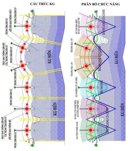
7 5 small-scale fishery, hereditary and attached to the sea. Follow time, fisheries and fishery villages have become more marked. Throughout the development process, in each fishing village there is often a combination of mining, processing, and combination of fisheries and other occupations. Villages in administrative organizations: Some communes consist of only one village but there are also several villages Situation of the organization of coastal fishing villages in the South Central Coast Space organization of coastal fishers in the study area Location: Coastal fishing villages are organized along coastal roads; Concentrate around bays, estuaries and coastal estuaries; Scattered along the coastal plain. The villages with geographic conditions, the same fishing grounds form clusters of villages. (Fig. 1.1.). Classification: based on geography - terrain, livelihood status, coastal fisherfolk villages are divided into three basic types: fisherman village in bay: concentrated in shallow waters with low depth; Fishermen village in estuaries: concentrated in coastal estuaries; VU NG BA N NGÂ P Figure 1.1. Space of coastal fishing villages

8 6 Environment - semi-tide sea water and river water; Fishermen village on the beach: concentrated in coastal sand banks; Strongly influenced by the ocean. Distribution scale: The number of administrative units considered as coastal fishing villages is about 108, accounting for more than 34%. Of which Binh Dinh: 29 units; Phu Yen: 33 units; a. Current situation Spatial structure of fishermen village clusters - coastal gulf area (example: O Loan lagoon area) b. Situation Spatial structure of fishermen village clusters - coastal estuaries (example: Tam Quan estuary) c. Situation The structure of the fishermen village cluster area - the coastal area (example: Tuy An beach Fig.1.2. Current situation Spatial structure of clusters of coastal fishing villages
9 7 Khanh Hoa: 46 units). The average population size of the coastal fishing village is about 3-5,000 people. Buildings, buildings in coastal fishing villages are built at high density and concentrated in some residential areas. Spatial structure of coastal fishing village clusters: coastal land space; Sea surface; Semi-flooded space. Current situation Spatial structure of coastal fishing village clusters: Evaluating the current situation on the basis of: functional subdivisions; Traffic connection; Climate change adaptation. (Fig. 1.2.) + Spatial structure of fishing village clusters - coastal bay area; + Spatial structure of fishing village clusters - coastal estuaries; + Spatial structure of fishing village clusters - coastal areas Space organization of functional areas coastal fishing village Functional areas and current land use status Spatial structure of coastal village space: Spatial composition of space: sea surface; Coastal land space; structures; Infrastructure - fish harbor. (Figure 1.3.). + Space structure of fishermen village - coastal bay area; + Spatial structure of fishermen village - coastal estuaries; + Space structure of fishermen village - coastal area. Space Coastal Village Landscapes: Coastal natural environment: including landscape and topography - natural sea, hills, forest ecosystems, mangroves, vegetation, sand dunes, marine ecosystems, Estuary... directly or indirectly affect the quality of the environment and the development of the village.


 of the coastal zone; Horizontal (mixed)")


10 8 Architectural landscape space includes the following areas: traditional village area, newly developed village area, adjacent area. Linkage of transportation network: waterway - the structure of the coastal fisherman village's space develops in the following directions: vertical (parallel to shore); Horizontal direction (perpendicular to shore) of the coastal zone; Horizontal (mixed) landscape line. a. Situation Space structure of fishermen village in the coastal bay area (example: Ninh Thuy village - Van Phong bay) b. Situation Space structure of fishermen village in coastal estuary (example: Phu Lac village, Da Nong river mouth) c. Situation Space structure of fishermen village - coastal area (example: Hon Yen village at Tuy An beach) Figure Current situation Space structure of coastal fishing village
11 Infrastructure and environment in coastal villages Social infrastructure + Public works: education - medical works; Offices, offices; Commercial buildings and services; Sports-culture; Religious and religious works. + Housing project: rural housing; Housing now. + Works & Services: Seafood processing industry; The cottage industry Technical and environmental infrastructure + Transportation network: Road transport: Coastal road, Commune road, Village road, People's road, Road connecting production areas; Railway traffic; Waterway. + Port works - fish landing. + Coastal environment + The environment of the wharf area - the fishing port, the coastal residential area Scientific and project works related to the topic Some scientific works are related to the topic + Coastal rural planning: introducing materials: 02 PhD theses; + Adaptation to climate change and sustainable development (SD): introduction of materials: 04 PhD theses and 03 scientific research projects in the country; 03 research projects abroad Some projects are related to the topic + Technical Assistance Project "Adaptation to climate change for sustainable development of agriculture and rural development in the coastal zone of the Mekong Delta"; + The Asian Cities Climate Change Resilience Network (ACCCRN) - "The Asian Cities Network is Resilient to Climate Change." 1.5. Issues to study in the organization of coastal villages in coastal areas of South Central Coast Some issues exist in the spatial organization of coastal fishing villages
12 10 + Structure - spatial function of coastal villages; + Landscape architecture - coastal environment; + Economic - technical infrastructure Research orientation of the thesis + Develop some views, principles and requirements for spatial organization for coastal fishing villages; + Proposed solutions to the planning of coastal fishing villages; + Proposing the model of spatial organization of coastal fishing village; + Proposed solutions for technical and environmental infrastructure; + Research proposal application. Chapter 2. SCIENTIFIC BASIS FOR THE ORGANIZATION OF COASTAL FISHING VILLAGES IN THE SOUTH CENTRAL COAST 2.1. Theoretical foundation of village space organization in coastal rural areas Coherence between sustainable rural planning and climate change adaptation + Sustainable Development and Climate Change Adaptation is a complex and systematic and interrelated relationship; + Climate change adaptation is in principle the solution to restore, maintain the environmental balance Ecosystem; + Sustainable rural development strategy is a pathway for socioeconomic development in harmony with the environment, mitigation and adaptation of climate change Organize a fisherman village space that integrates climate change issues Spatial structure of fisherman village towards sustainability: linear planning model; Form of rural settlement. (Figure 2.1.)


13 11 Figure 2.1. The settlement model is concentrated in coastal rural areas: A. Linear Village; B. Village concentration; C. Village in rounds; D. Village with walls; E. Village network Adaptation of climate change adaptation to spatial organization: integration of climate change; Integrated planning; The theory of elastic space. (Figure 2.2.) In the area of integrated planning - integration of climate change adaptation and ecosystem-based adaptation - sustainable development; The theory of elastic space is a positive trend. The rural areas can apply research in the form of organization under each zoning, the flexible area, flexible development to adapt to climate change. Figure 2.2. Compare the durability and resilience of two spaces in flood intensity 2.2. Relevant legal basis for coastal rural construction planning Development Policy & Standards Standards Relevant policy and policy: Vietnam Marine Strategy; Action Plan on agriculture, farmers and rural areas; Law of the Sea of Vietnam; Law on marine and island natural resources and environment; National target program on new rural construction;
14 12 Approving the Vietnam Sustainable Development Strategy; Strategy for sustainable exploitation and use of natural resources and protection of the marine environment; Regulations and standards for rural construction planning: National technical regulation on rural construction planning (QCXDVN14: 2009 / BXD); National set of criteria for new countryside; Rural construction planning regulations; Guidance on the selection of rural road technical sizes for the national target program on new rural construction Relevant construction plans have been approved + Planning the South Central Coast; + New rural construction planning; + Relevant branch planning: planning for the development of the fisheries sector in South Central Vietnam; Overall planning for tourism development in the South Central Coast The conditions that shape the organization of the fisherman village space Natural conditions - coastal resources + Geology - topography - soil: topography: Slope decreases from west to east; Hilly terrain types, river deltas, coastal areas and islands. Geology: The stability of the geologic layers is relatively good; Soil: Sandy soil, Saline soil. + Hydrographical climate: tropical monsoon climate in the sea; + Water resources: Fresh water is abundant; + Marine resources: Large fishing grounds, rich in seafood; Favorable aquaculture; Many beaches, tourism Impact on socio-economic development + Urbanization in the South Central Region: Promote the socioeconomic development of the region; Issue many issues to address. + Socio-economic development of the media: potential marine economy; Coastal social capacity. + Condition of application of new technology: fishing technology; Development of mechanics of ship building and repair;
15 13 The model of linking production and exploitation of marine products; Product preservation technology; Logistics base Climate Change Impact Scenario + Impact of climate change - sea level rise; + Climate change scenarios in the South Central Coast; + Forecasting the impact of Climate Change Trends in the spatial variation of coastal fishing villages in the South Central Coast Trend of overall space transformation of coastal fishing villages + Transformation within the network, the chain of coastal fishing villages; + Spatial connection of coastal fishing villages with other rural and urban areas Trends of changing coastal functional spaces + Transformation of coastal water surface: Transformation of natural water surface into aquaculture areas; Conversion of natural water surface into the water surface of the harbor; Transform natural water surface into an entertainment area. + Transformation in the space of coastal fishermen village: The trend of change inside the coastal fishing village; Trends of development go beyond coastal fishing village space Trends in the transformation of landscape space - infrastructure + Landscape space change - social infrastructure; + Space of technical infrastructure - harbor Experience organizing spat fishing villages in the countryside and in the country Some countries in the world + Korea, Saemangeum Development Project; + Autralia, Coastal Village Development Project in Moreton Bay Vietnam
16 14 + Experience on coastal sustainable development in Cu Lao Dung, Tran De and Vinh Chau Provinces of Soc Trang Province. + Experience on sustainable development of Tam Giang - Cau Hai lagoon in Thua Thien Hue coastal area. + Experience on sustainable development of coastal communes of An Hai, Phuoc Dinh, Phuoc Hai, Ninh Thuan province Summarize some lessons learned To settle, maintain and exploit in the capacity of restoring material, social and coastal resources; Relying on the relationships between people and people; Construction of spatial structures capable of carrying out their functions in a continuous and steady manner over time; Solutions based on physical infrastructure; Solution based on different funding sources; Institutions, laws, and policies. Lessons learned from the organization of the coastal village fishermen's village did not mention the village model associated with functional spaces. Chapter 3. PROPOSED MODEL OF SPATIAL ORGANIZATION OF COASTAL FISHING VILLAGES IN THE SOUTH CENTRAL COAST 3.1. Perspective, principle Perspective Five basic points: Organizing coastal fishing village space in the direction of sustainable development and adaptation to climate change; Organizing coastal village fishermen's space is carried out in the contents of: spatial development orientation and construction planning; Organize coastal fishing village space; Integrate adaptation measures to climate change; Community-based development Principle Seven Fundamental Principles: Sustainable Development; Determine the classification of coastal fishing villages; Modeling; Exploiting and using land and water surface effectively; Construction system; Technical infrastructure; Participatory planning.
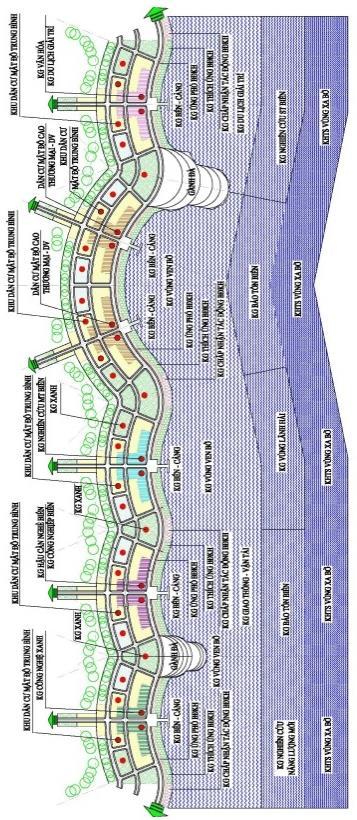
17 Proposed a number of requirements for spatial organization of coastal fishing villages Requires Sustainable Coastal Settlement Content required "Sustainable Coastal settlement": coastal ecological environment; The infrastructure; Community culture of fishermen; Mining technology, production economics; Institutional management Request for Sustainable Coastal Architecture Content required "Sustainable Coastal Architecture": Location of construction; Energy consumption; Water efficiency; Building materials; Space architectural landscape; Climate change adaptation - sea level rise; Built environment and application initiative The model of spatial organization of coastal fishing villages in the South Central Coast Functional connectivity in the coastal fishing village Functional space composition: village center space; Transition space; Sea space. Interconnection between spaces: Connection between village center space and marine space; Connection between village center space and transition space; Connection between sea space and transition space Development axis and interference space to adapt to climate change Space Development Spans: Marine Economic Axis, Connection Axis, Axis of Renewal. Interfering spaces: Cross-village space and marine space; Cross-village space space and transition space; Interfaces of transitional spaces and marine spaces; Cross village space interiors, transitional spaces and marine spaces. Organization of architectural space landscape coastal fishing village: connection space: Array - Axes - Landscapes The model of spatial organization of coastal fishing villages by classification Model of fisherman village space - coastal lagoon
18 16 + Connection between fisherman village spaces - coastal lagoon areas: Composition Spatial structure; Connection between spaces; Spatial spatial development; Main interference spaces + The model of spatial organization of fishermen's villages in coastal lagoon and sea areas: Spatial structure: population centers, roads and waterways; Functional space: Transitional space, Marine space ( Lagoon - Bay), Village center space: (Figure 3.1.) Size: 3,000-5,000 people, k = m2/person, area: 35-60ha, space of residence, production space - services, traffic space - technical infrastructure, green space, Minimize the impact of climate change. Model of spatial organization of fishermen villages in coastal estuaries + Connection between the village space of fishermen in coastal estuaries: Components of space structure, connection between spaces; Spatial spatial development; Main interference spaces + The model of spatial organization of fishermen's villages in coastal estuaries: Spatial structure: population centers, roads and waterways; Functional space: Transitional space, Marine space (Dam - Bien Bien), Village center space (Figure 3.2). Size: 3,500-5,500 people, k = m2 / person, area: 40-60ha, space of residence, production space - service, traffic space - technical infrastructure, green space, Minimize the impact of climate change. Model of space organization of coastal fishermen village + Connection between the village space of fishermen on coastal areas: Components of space structure, connection between spaces; Spatial spatial development; Main interference spaces + The model of spatial organization of coastal fishermen's village clusters: Spatial structure: population centers, roads and waterways; Functional space: Transitional spaces, Marine spaces (Dam - Bien Bien), Village center space: (Figure 3.3.) Size: 2,500-4,500 people, k = m2 / person, area: 30-
19 17 50ha, space of residence, production space - service, traffic space - technical infrastructure, green space, Minimize the impact of climate change Total planning solution for coastal fishing villages The overall space structure of the village fisherman clusters Completing the overall planning system of coastal fishing village groups, especially those with favorable and natural conditions, on the chain of fishing villages in the South Central Coast. To concentrate investment on the planning of construction of coastal fishing villages with clear hierarchy. Improve the rehabilitation capacity of fishing villages in the chain of coastal villages Organize functional space village fisherman clusters Village cluster center space: public service area; Residential area; Commercial, manufacturing and service areas. Transition space: Space for community recreation; Study space; Production space. Marine Space: Aquaculture space; New Energy Research Space - Entertainment Services; Organization of technical infrastructure space: Transportation; Marine technical infrastructure; Environment Solutions on technical infrastructure and coastal fishing village environment Construction work preparation Construction height controlled in Space Organization: Complete surface drainage system; Measures to prevent and mitigate natural disasters; Elevation of foundation; Divide by terrain elevation and distance to shore Technical Infrastructure Planning + General technical solution; Specific technical solutions; Planning a fishing harbor Some solutions to protect the coastal village fishermen + Coastal Environment Organization; Community participatory environmental management solution.


20 18 Figure 3.1. Model of spatial organization of fisherman village in coastal lagoon.


21 19 Figure 3.2. Model of spatial organization of fishermen villages in coastal estuaries

22 20 Figure 3.3. Model of space organization of coastal fishermen village
23 Study example: Spatial organization model of fishing village in De Gi Lagoon - Binh Dinh Province Some requirements in the space organization of fishermen in the De Gi lagoon area: The purpose of spatial organization; Scope and timing of planning; Views, principles; Requirement of Sustainable settlement and Sustainable architecture; Location area study area Review of the organization of fishermen's village space in De Gi lagoon: Spatial structure of fishermen village in De Gi lagoon: Spatial structure of fishermen's village; Spatial organization of the village centers along the De Gi lagoon. Natural conditions - natural resources; Socio-economic impact; Climate change impact The model of space organization of fishermen in De Gi lagoon Spatial connectivity in the fishermen's village of De Gi Lagoon: Components Spatial structure: towards sustainable development including spaces: village center space, transition space, marine space. Interconnection between spaces: Connect multiple resources; Linking habitat change; Climate change and Sea level rise; Development. Spatial development axis: Sea economic axis; Connecting shaft; Reform shaft. Main Interference Space: Climate Change Adaptation - EbA; Ecological preservation space (De Gi Lagoon); Space for ecological development; Space of ecological balance; Mixed ecological mixed space. Model of space organization of fishermen in De Gi Lagoon: Spatial structure: population centers; Road; Waterway. Functional space: transitional space; Marine space; Center space of the village - (Ngai An fishermen's village): Living space, production space - services, traffic space - technical infrastructure, green space, minimizing the impact of climate change. Figure 3.4.
24 Totalitarian planning solution for the village of fishermen in De Gi Lagoon Village center space: public service area; Residential area; Commercial - production - service area. Transition space: Space for tourism - community recreation; Study space; Production space. Marine Space: Exploiting Space; Aquaculture space; New Energy Research Space - Entertainment Services. Infrastructure planning: transport system; Marine technical infrastructure; Environment Solution on technical infrastructure planning and environment of fishermen village in De Gi Lagoon Construction work; Technical infrastructure, environment Discuss the research results Overview of spatial organization of coastal fishing villages in the South Central Coast: Through the system, analysis and assessment of the situation, the results of the overview of spatial organization of the coastal fishing village in the study area were obtained: relatively comprehensive. The synthesis and the system of related scientific backgrounds contribute to a more complete theoretical and practical basis in the development of the next steps. Model of fisher village space organization by category: Perspectives, principles, requirements for the organization of coastal fishing village space. Interactive spaces, interference is one of the preconditions for climate change adaptation, forming the network "Green countryside" coastal. Proposed application model in De Gi Lagoon: The need to use coastal space is considered and arranged in detail. The central space center of the coastal fishermen village and Ngai An village is suitable for fishermen living today. The development of coastal rural areas must be tied to the integration of specific environmental, economic, cultural and social issues in the coastal zone. The approach to organizing coastal village fishermen's village in the dissertation has somehow proved to be


25 23 suitable with the present context, which can reconcile, satisfy the requirements of sustainable development and adaptation. Figure 3.4. Organizational model of LND space in De Gi lagoon.
26 24 CONCLUSIONS AND RECOMMENDATIONS 1. Conclusion Arguments, data and model The dissertation has demonstrated the adaptability of CC and sustainable development in the spatial organization of the coastal fishing village. (1). Based on the collection and analysis of the conditions established the views, principles and requirements of spatial organization of coastal fishing villages in the South Central Coast. (2) Spatial structure of clusters of coastal fishing villages in the South Central Coast in line with sustainable development and climate change adaptation. (3) Proposed spatial organization model for fisherfolk villages in coastal areas: bay lagoons, estuaries and horizontal beach. (4) Proposing some measures to protect the environment, infrastructure in the direction of climate change adaptation - based on ecosystem. (5) Dissertation for Choi - Binh Dinh lagoon for research application. The thesis is of reference value, applied in the organization of space of coastal fishermen villages with conditions similar to the South Central Coastal region. 2. Recommendations (1). On policy - management: Specify action plans and tasks; Ensure plan integration, task connection; Improve operational efficiency. (2). Regarding the establishment and implementation of coastal space village organization: To focus on sustainable and ecosystem-based adaptation measures for coastal livelihoods; Strengthening the management of institutions, policies, science and technology, information, warning forecasting and improvement of legal documents; Mobilize community participation. (3). For research and teaching activities: To step by step build and perfect the regional and urban designing and planning programs; Research and innovation approach to coastal space organization in the direction of integrating adaptation to climate change - sea level rise.
27 25 LIST OF SCIENTIFIC RESEARCH PROJECTS DISCLOSED OF AUTHORS RELATED TO THESIS Science articles 1. Tran Van Hien (2015), Fishing ports spatial organization in coastal village with sustainable development, Journal of Vietnamese Architecture, 12/2015, ISSN Tran Van Hien (2016), Exploitation of these factors in the area characteristics of fishermen village planning "Rural New" south centralcoastal towards sustainable development, Construction Journal, Review of Ministry of Construction, No ISSN Scientific Research Conference 1. Tran Van Hien (2014), Architectural training in Central Coastal area associated with climate change and Green architecture, Scientific Conference with the theme "Renovation of teaching curricula towards green building And climate change, "Institute of Tropical Architecture - Hanoi University of Architecture, T Tran Van Hien (2015), Spatial organization of coastal fishing villages in the South Central region towards sustainable development and adaptation to climate change, Scientific Conference "Southern Central Preservation, Integration, Sustainability, Vietnam Association of Architects MienTrung University of Civil Engineering (MUCE), T
Vietnam Coastal Erosion - Cause and Challenges -
 Administration of Sea and Islands Center for Oceanography University of Transport and Communications, Hanoi Vietnam Vietnam Coastal Erosion - Cause and Challenges - Presenters: Pham Hoang KIEN Le Van CONG
Current Status of Vietnam Coastal Erosion and Major Measures for Mitigation
 Vietnam Administration of Sea and Islands Center for Oceanography University of Transport and Communications Current Status of Vietnam Coastal Erosion and Major Measures for Mitigation Case Study: Thanh
Populations effected by flood top ten districts
 2050 - Populations effected by flood top ten districts 14 Extreme A2 Extreme A2 with dyke District Area (Ha) Population 2050 People affected Percent area affected People affected Percent area affected
Land Use in the context of sustainable, smart and inclusive growth
 Land Use in the context of sustainable, smart and inclusive growth François Salgé Ministry of sustainable development France facilitator EUROGI vice president AFIGéO board member 1 Introduction e-content+
Country Fiche Lithuania
 Country Fiche Lithuania Updated June 2018 1. General information The Lithuanian maritime space is delimited by the Decree of the Government of the Republic of Lithuania of 6 December, 2004, No. 1597 and
TOWARDS CLIMATE-RESILIENT COASTAL MANAGEMENT: OPPORTUNITIES FOR IMPROVED ICZM IN BELIZE
 TOWARDS CLIMATE-RESILIENT COASTAL MANAGEMENT: OPPORTUNITIES FOR IMPROVED ICZM IN BELIZE CHANTALLE SAMUELS Coastal Zone Management Authority and Institute The Caribbean Community Climate Change Centre VULNERABILITY
National Perspectives - Portugal. Margarida Almodovar
 National Perspectives - Portugal Margarida Almodovar margarida.almodovar@mam.gov.pt from base line to the external limit of the continental shelf behind 200 miles and according to UNCLOS definitions Economic
TOWARDS STRATEGIC SPATIAL PLANNING IN JAMAICA: THE NATIONAL SPATIAL PLAN
 TOWARDS STRATEGIC SPATIAL PLANNING IN JAMAICA: THE NATIONAL SPATIAL PLAN JIEP 5th Biennial Conference on the Environment: Balancing National Development and Environmental Protection June 6, 2011 Jamaica
Proposal for Research and Investment Activities in the Coast and Estuaries (A Case Study in the North Central Coast of Viet Nam)
") 2017/SOM3/EPWG/019 Agenda Item: 7.2.3 Proposal for Research and Investment Activities in the Coast and Estuaries (A Case Study in the North Central Coast of Viet Nam) Purpose: Information Submitted by:
2017/SOM3/EPWG/019 Agenda Item: 7.2.3 Proposal for Research and Investment Activities in the Coast and Estuaries (A Case Study in the North Central Coast of Viet Nam) Purpose: Information Submitted by:
Moreton Bay and Key Geographic Concepts Worksheet
 Moreton Bay and Key Geographic Concepts Worksheet The Australian Curriculum: Geography draws on seven key geographic concepts: place scale space environment change interconnection sustainability They are
EUSAIR on sea topics from Slovenian perspective
 MINISTRY OF FOREIGN AFFAIRS REPUBLIC OF SLOVENIA EUSAIR on sea topics from Slovenian perspective Mag. Andreja Jerina National Coordinator 4 EU MRS: 270 millions of population 19 MS 12 non MS Sea basin
Welcome to GCSE Geography. Where will it take us today?
 Welcome to GCSE Geography Where will it take us today? Urban Futures Dynamic Development Resource Reliance UK in the 21 st Century Global Hazards Changing Climate Distinctive Landscapes Sustaining Ecosystems
Building the Sustainable Network of Settlements on the Caspian Sea Region of Kazakhstan
 Building the Sustainable Network of Settlements on the Caspian Sea Region of Kazakhstan Introduction The Ecological Zoning and Identification of Ecological Capacity of Natural and Socio- Economic Potential
What is Spatial Planning?
 Spatial Planning in the context of the Responsible Governance of Tenure What is Spatial Planning? Text-only version This course is funded by the European Union through the EU-FAO Improved Global Governance
International Symposium on Natural Disaster Mitigation. Local vulnerability assessment of landslides and debris flows
 International Symposium on Natural Disaster Mitigation of landslides and debris flows Lessons learnt from Cam Pha town and Van Don district, Quang Ninh province, Vietnam Nguyen Quoc Phi Faculty of Environment
CLLD Cooperation OFFER
 Title of the proposed project (English) CLLD Cooperation OFFER PARKS PROTECTION III - Management, Protection and Economic Development in Protected Areas Type of project (select as many as you want) Cooperation
DRAFT PROGRAM Registration of participants, welcome coffee, exhibition tour
 DRAFT PROGRAM 20 Feb 2018 09.00-10.00 Registration of participants, welcome coffee, exhibition tour 10.00 12.00 ROUND TABLE: INTERNATIONAL COOPERATION IN THE ARCTIC PROJECTS: CHALLENGES AND OPPORTUNITIES
GIS Geographical Information Systems. GIS Management
 GIS Geographical Information Systems GIS Management Difficulties on establishing a GIS Funding GIS Determining Project Standards Data Gathering Map Development Recruiting GIS Professionals Educating Staff
Marine/Maritime Spatial Planning Andrej Abramić
 Marine/Maritime Spatial Planning Andrej Abramić EcoAqua SUMMER SCHOOL: Ecosystem approach to aquaculture 26-29th of October 2015 Research and Technology to enhance excellence in Aquaculture development
2014 Summer training course for slope land disaster reduction Taipei, Taiwan, Aug
 MINISTRY OF SCIENCE AND TECHNOLOGY HYDROTECH RESEARCH INSTITUTE MINISTRY OF NATURAL RESOURCES AND ENVIRONMENT VIETNAM INSTITUTE OF GEOSCIENCES AND MINERAL RESOURCES (VIGMR) 2014 Summer training course
Marine Spatial Planning Leslie-Ann McGee Battelle Memorial Institute
 Marine Spatial Planning Leslie-Ann McGee Battelle Memorial Institute Rev061708 1 Marine Spatial Planning What is it? Why is it different? Where is it currently being employed? What is happening in the
This table connects the content provided by Education Perfect to the NSW Syllabus.
 Education Perfect Geography provides teachers with a wide range of quality, engaging and innovative content to drive positive student learning outcomes. Designed by teachers and written by our in-house
The UN-GGIM: Europe core data initiative to encourage Geographic information supporting Sustainable Development Goals Dominique Laurent, France
 INSPIRE conference Strasbourg 6 September 2017 The UN-GGIM: Europe core data initiative to encourage Geographic information supporting Sustainable Development Goals Dominique Laurent, France Introduction
16540/14 EE/cm 1 DG E 1A
 Council of the European Union Brussels, 5 December 2014 (OR. en) 16540/14 ENV 965 CULT 139 NOTE From: To: Subject: General Secretariat of the Council Delegations Charter of Rome on Natural and Cultural
Oceans in transition
 Oceans governance Oceans in transition OECD: Ocean industry value-added projected to double by 2030 from ~USD 1.5 to 3.0 trillion However, meeting anticipated demand for ocean space and resources will
Jordan's Strategic Research Agenda in cultural heritage
 Jordan's Strategic Research Agenda in cultural heritage Analysis of main results Alessandra Gandini Amman, Jordan 3 rd November 2013 Main objectives The work performed had the main objective of giving
Rencontres de Hanoï The Amendment to Hanoi Capital Regional Plan:
 Rencontres de Hanoï The Amendment to Hanoi Capital Regional Plan: Resuming working ties with Vietnamese urban planning authorities after 20 years of absence The Institut d Aménagement et d Urbanisme d
Disaster Prevention and Management in Asia: The Context of Human Security and Its Relevance to Infrastructure Planning and Management
 Disaster Prevention and Management in Asia: The Context of Human Security and Its Relevance to Infrastructure Planning and Management Rajib Shaw http://www.iedm.ges.kyoto-u.ac.jp/ Contents Background and
Land Use Planning and Agriculture: Austrian Experiences and Challenges I
 Land Use Planning and Agriculture: Austrian Experiences and Challenges I SULANET Summer School 2016 Walter Seher BOKU Vienna 1 Land Use Planning and Agriculture 2 Land Use Planning and Agriculture Agriculture
Investigation, assessment and warning zonation for landslides in the mountainous regions of Vietnam
 Investigation, assessment and warning zonation for landslides in the mountainous regions of Vietnam (State-Funded Landslide Project SFLP) Dr. Eng. Le Quoc Hung Add: 67 Chien Thang Street, Ha Dong District,
Sri Lanka has a coastline of km excluding the shoreline of bays and inlets.
 Defining and Demarcating Coastal zones in Sri Lanka Procedure, Challenges and What needs to be done? Dr. Anil Premaratne Director General Coast Conservation Coast Conservation Department Sri Lanka 1 Sri
Assessment of climate change impacts on salinity intrusion in Hong-Thai Binh and Dong Nai river basins
 VNU Journal of Science, Earth Sciences 27 (2011) 54-61 Assessment of climate change impacts on salinity intrusion in Hong-Thai Binh and Dong Nai river basins Tran Hong Thai, Tran Thi Van* Vietnam Institute
The Contested Cultural Landscape of a Lebanese Border Town: MARJA AYOUN
 The Contested Cultural Landscape of a Lebanese Border Town: MARJA AYOUN IBD 2013 FNAS MAY 2013 Dr. Christine Mady, City & Regional Planning NDU -FAAD In this Presentation A PLANNING PERSPECTIVE INTRODUCING
Scientific bases for defining the coastal zone of Quang Binh, Quang Tri, Thua Thien Hue provinces
 VNU Journal of Science, Earth Sciences 26 (2010) 8-18 Scientific bases for defining the coastal zone of Quang Binh, Quang Tri, Thua Thien Hue provinces Nguyen Hieu*, Nguyen Cao Huan, Dang Van Bao Hanoi
DETERMINE OF REGIONAL DEVELOPMENT STRATEGIES IN IZMIR
 Sukran Yalpir Asli Bozdag Saban Inam DETERMINE OF REGIONAL DEVELOPMENT STRATEGIES IN IZMIR Globalization INTRODUCTION Economic pressure cause Economic migration cause cause Spatial organizations Spatial
Navigable maritime and river waterways in the seaside - Danube Delta area and the connected rural development
 SUMMARY OF Ph-D Thesis, with title RESEARCH STUDIES ON MANAGEMENT IMPROVEMENT OF MARITIME AND RIVER TRANSPORT ACTIVITY IN THE COASTAL AND DANUBE DELTA AREA FROM AN ENVIROMENTAL, ECONOMIC AND SOCIAL PERSPECTIVE
Legal problems of environmental management. Spatial planning and space management. M. Gajewski 2014 / 2015
 Legal problems of environmental management Spatial planning and space management M. Gajewski 2014 / 2015 Course contents (in brief) Constitutional basis of the environment protection system. General principles
Urban Climate Resilience
 Urban Climate Resilience in Southeast Asia Partnership Project Introduction Planning for climate change is a daunting challenge for governments in the Mekong Region. Limited capacity at the municipal level,
HEAVY RAIN OVER MID-CENTRAL REGION OF VIETNAM
 HEAVY RAIN OVER MID-CENTRAL REGION OF VIETNAM ----------------------------------------------------------------------- S.Eng. Dang Thi Mai; Dr. Nguyen Thi Tan Thanh National Hydro Meteorological Service
Applying ArcGIS Online for Establishing Hanoi Agriculture Map
 Applying ArcGIS Online for Establishing Hanoi Agriculture Map Thanh Xuan Nguyen Geography Department Hanoi National University of Education mrthanhxuan@gmail.com Tien Yin Chou GIS Research Center Feng
SPLAN-Natura Towards an integrated spatial planning approach for Natura th January, 2017 Brussels. Commissioned by DG Environment
 SPLAN-Natura 2000 Towards an integrated spatial planning approach for Natura 2000 Commissioned by DG Environment 17 th January, 2017 Brussels V. Simeonova (Ph.D.) Drivers towards integrating Biodiversity
Huong River. Serial No. : Viet Nam-8 Location: Thua Thien Hue Province, Viet Nam N 16 00' '
 Viet Nam 8 Huong River Map of River Table of Basic Data Name: Huong River Serial No. : Viet Nam-8 Location: Thua Thien Hue Province, Viet Nam N 16 00' - 14 40' E 107 07' - 107 50' 2 Area: 2,830 km Length
Newsletter # 2. Pilot sites in Greece. December 2018
 A HarmonizEd framework to Mitigate coastal EroSion promoting ICZM protocol implementation Newsletter # 2 December 2018 View of a beach in Ammolofi ( Paggaio Municipality ) Pilot sites in Greece 1. Name
Department of Geography: Vivekananda College for Women. Barisha, Kolkata-8. Syllabus of Post graduate Course in Geography
 India: Regional Problems and Resource management Module 11 (Full Marks 50) Unit I: Region and Regionalisation 1.1 Various bases of regionalisation of India; problems of identification and delineation.
Seabed knowledge In support of UN SDGs
 Seabed knowledge In support of UN SDGs Evert Flier Fiskerifaglig forum 2. november 2017 Hydrography & small scale fishing Hydrography in Transition Serving the Maritime Community Hydrography in Transition
Croatian physical planning system and strategic approach to MSP
 W 1/7 Past two years all over the Europe: case studies 2 Croatian physical planning system and strategic approach to MSP Vesna Marohnić Kuzmanović Head of Department Croatian Institute for Spatial Development
Measuring Disaster Risk for Urban areas in Asia-Pacific
 Measuring Disaster Risk for Urban areas in Asia-Pacific Acknowledgement: Trevor Clifford, Intl Consultant 1 SDG 11 Make cities and human settlements inclusive, safe, resilient and sustainable 11.1: By
DAGUPAN CITY EXPERIENCES, GOOD PRACTICES, CHALLENGES AND LESSONS LEARNED ON DISASTER RISK MANAGEMENT
 DAGUPAN CITY EXPERIENCES, GOOD PRACTICES, CHALLENGES AND LESSONS LEARNED ON DISASTER RISK MANAGEMENT Reducing Vulnerability to Climate Change Impacts and Related Natural Disasters in East Asia 12 and 13
Designing Networks of Marine Protected Areas in DFO s Three Atlantic Bioregions
 Designing Networks of Marine Protected Areas in DFO s Three Atlantic Bioregions Presentation for Indigenous Protected Areas Workshop Max Westhead, DFO and Adrian Gerhartz-Abraham, Dalhousie March 29, 2017
Marine Spatial Planning as an important tool for implementing the MSFD
 Marine Spatial Planning as an important tool for implementing the MSFD Risto Kalliola Tallinn, Nov. 16 th 2012 DEPARTMENT OF GEOGRAPHY AND GEOLOGY University of Turku, Finland Ten principles to provide
BOSNIA AND HERZEGOVINA
 Studies to support the development of sea basin cooperation in the Mediterranean, Adriatic and Ionian, and Black Sea CONTRACT NUMBER MARE/2012/07 - REF. NO 2 REPORT 1 - ANNEX 2.2 COUNTRY FICHE - ANNEX
Advanced Placement Human Geography
 Advanced Placement Human Geography Introduction to AP Human Geography The Advanced Placement course in Human Geography is designed to introduce students to the systematic study of the processes that have
Tuition, Medical and Behaviour Support Service
 Tuition, Medical and Behaviour Support Service Curriculum Policy - Primary Geography Reviewed: October 2018 Next Review: October 2019 Responsibility: Andrea Snow AIMS AND PRINCIPLES The national curriculum
The National Spatial Strategy
 Purpose of this Consultation Paper This paper seeks the views of a wide range of bodies, interests and members of the public on the issues which the National Spatial Strategy should address. These views
Implementation Status & Results Vietnam Second Northern Mountains Poverty Reduction Project (P113493)
") Public Disclosure Authorized Public Disclosure Authorized The World Bank Implementation Status & Results Vietnam Second Northern Mountains Poverty Reduction Project (P113493) Operation Name: Second Northern
Public Disclosure Authorized Public Disclosure Authorized The World Bank Implementation Status & Results Vietnam Second Northern Mountains Poverty Reduction Project (P113493) Operation Name: Second Northern
Coastal Environment. Introduction. 4.1 Coastal Environment. Extent of Coastal Environment
 4 The primary objective (set out in Chapter 2) to be implemented by this Chapter is Objective 2.4 ; the following objectives are also relevant due to the objectives integrated nature: 2.1 Tāngata whenua
Why Do We Live Here? : A Historical Geographical Study of La Tabatiere, Quebec North Shore
 Why Do We Live Here? : A Historical Geographical Study of La Tabatiere, Quebec North Shore Lesson Overview Many communities and their occupants have historical connections to exploration routes and traditional
PHOTOGRAMMETRY AND GIS TECHNOL 1 OGIES FOR MONITORING COASTAL EROSION ALONG DAR ES SALAAM COASTLINE. By: Z.Y Masele, S.D Mayunga1.
 PHOTOGRAMMETRY AND GIS TECHNOL 1 OGIES FOR MONITORING COASTAL EROSION ALONG DAR ES SALAAM COASTLINE. By: Z.Y Masele, S.D Mayunga1 Abstract Dar Es salaam coastline is seriously suffering from coastal soil
Assessment of Sustainable Land Use within the Town Planning Process Experiences with a Multi Criteria Approach (MCA)
") Assessment of Sustainable Land Use within the Town Planning Process Experiences with a Multi Criteria Approach (MCA) Dipl.-Geogr. Sophie Schetke Dipl.-Ing. Benedikt Frielinghaus, University of Bonn, Germany
Assessment of Sustainable Land Use within the Town Planning Process Experiences with a Multi Criteria Approach (MCA) Dipl.-Geogr. Sophie Schetke Dipl.-Ing. Benedikt Frielinghaus, University of Bonn, Germany
Monitoring Urban Space Expansion Using Remote Sensing Data in Ha Long City, Quang Ninh Province in Vietnam
 Monitoring Urban Space Expansion Using Remote Sensing Data in Ha Long City, Quang Ninh Province in Vietnam MY Vo Chi, LAN Pham Thi, SON Tong Si, Viet Key words: VSW index, urban expansion, supervised classification.
CHAPTER 4 HIGH LEVEL SPATIAL DEVELOPMENT FRAMEWORK (SDF) Page 95
 Page 95") CHAPTER 4 HIGH LEVEL SPATIAL DEVELOPMENT FRAMEWORK (SDF) Page 95 CHAPTER 4 HIGH LEVEL SPATIAL DEVELOPMENT FRAMEWORK 4.1 INTRODUCTION This chapter provides a high level overview of George Municipality s
CHAPTER 4 HIGH LEVEL SPATIAL DEVELOPMENT FRAMEWORK (SDF) Page 95 CHAPTER 4 HIGH LEVEL SPATIAL DEVELOPMENT FRAMEWORK 4.1 INTRODUCTION This chapter provides a high level overview of George Municipality s
The Socio Economic Development of the Marine Sector in the Atlantic Area. Stephen Hynes
 The Socio Economic Development of the Marine Sector in the Atlantic Area Stephen Hynes Overview SEMRU and its role in Marine Socioeconomic analysis Defining Ocean and Coastal Economies in the Atlantic
Recent development of the National Hydro-Meteorological Service (NHMS) of Viet Nam for disaster risk reduction
 of Viet Nam for disaster risk reduction") Ministry of Natural Resources and Environment National Hydro-Meteorological Service Recent development of the National Hydro-Meteorological Service (NHMS) of Viet Nam for disaster risk reduction Tran Van
Ministry of Natural Resources and Environment National Hydro-Meteorological Service Recent development of the National Hydro-Meteorological Service (NHMS) of Viet Nam for disaster risk reduction Tran Van
Cross-border Maritime Spatial Plan for the Black sea - Romania and Bulgaria project
 Cross-border Maritime Spatial Plan for the Black sea - Romania and Bulgaria project in Romania and Bulgaria Plan Presentation A first step in the management of the marine areas of Romania and Bulgaria
EVALUATION OF THE VULNERABILITY OF TitleCOASTAL SOCIO-NATURAL SYSTEMS (EXAM FROM KHANH HOA COASTAL ZONE) Author(s) Nguyen, Thi Thuy Hang; Pham, Hung T
 Author(s) Nguyen, Thi Thuy Hang; Pham, Hung T") EVALUATION OF THE VULNERABILITY OF TitleCOASTAL SOCIO-NATURAL SYSTEMS (EXAM FROM KHANH HOA COASTAL ZONE) Author(s) Mai, Trong Nhuan; Tran, Thanh Hai; Nguyen, Thi Thuy Hang; Pham, Hung T Annual Report of
EVALUATION OF THE VULNERABILITY OF TitleCOASTAL SOCIO-NATURAL SYSTEMS (EXAM FROM KHANH HOA COASTAL ZONE) Author(s) Mai, Trong Nhuan; Tran, Thanh Hai; Nguyen, Thi Thuy Hang; Pham, Hung T Annual Report of
MEDIUM TERM DEVELOPMENT PLAN: RPJMN Director of Forestry and Water Resources Conservation Bappenas
 MEDIUM TERM DEVELOPMENT PLAN: RPJMN 2015-2019 Director of Forestry and Water Resources Conservation Bappenas Jakarta, 9 March 2015 1 I. RPJMN 2015-2019 2 VISION AND MISSION 2015-2019 VISION: INDONESIA:
Public Disclosure Copy
 Public Disclosure Authorized EAST ASIA AND PACIFIC Vietnam Environment & Natural Resources Global Practice IBRD/IDA Investment Project Financing FY 2016 Seq No: 1 ARCHIVED on 03-Nov-2016 ISR25240 Implementing
Socials Studies. Chapter 3 Canada s People 3.0-Human Geography
 Socials Studies Chapter 3 Canada s People 3.0-Human Geography Physical Geography Study of the natural features of the Earth s surface including landforms, climate, ocean currents and flora and fauna Human
State initiative following up the 2006 national planning report
 18 ness districts and public institutions, should be integrated with the opportunities for public transport services. State initiative following up the 2006 national planning report The Ministry of the
5.2. Historic heritage. Photo: Vaughan Homestead, Long Bay Regional Park, Auckland. (Source: ARC). Historic heritage
. Historic heritage") Photo: Vaughan Homestead, Long Bay Regional Park, Auckland. (Source: ARC). 274 Hazards and heritage Contents 5.2 Introduction 276 monitoring programmes 276 The state of historic heritage 277 Heritage items
Photo: Vaughan Homestead, Long Bay Regional Park, Auckland. (Source: ARC). 274 Hazards and heritage Contents 5.2 Introduction 276 monitoring programmes 276 The state of historic heritage 277 Heritage items
Disaster Management & Recovery Framework: The Surveyors Response
 Disaster Management & Recovery Framework: The Surveyors Response Greg Scott Inter-Regional Advisor Global Geospatial Information Management United Nations Statistics Division Department of Economic and
MEADOWS PRIMARY SCHOOL and NURSERY GEOGRAPHY POLICY
 MEADOWS PRIMARY SCHOOL and NURSERY GEOGRAPHY POLICY Purpose of study The teaching of Geography at Meadows is done by following the 2014 National Curriculum. The planning and teaching of the subject aims
GEOGRAPHY POLICY STATEMENT. The study of geography helps our pupils to make sense of the world around them.
 GEOGRAPHY POLICY STATEMENT We believe that the study of geography is concerned with people, place, space and the environment and explores the relationships between the earth and its peoples. The study
Declaration Population and culture
 Declaration Population and culture The ministers of the parties to the Alpine Convention regard the socio-economic and socio-cultural aspects mentioned in Article 2, Paragraph 2, Item a., as being central
WELCOME & INTRODUCTION
 MPA Management Capacity Building Training Module 1: WELCOME & INTRODUCTION Participants Distinguished Guests Welcome Site Overviews of MPAs represented Overview of Training Program What are Today s Objectives?
BURGAS CASE STUDY: LAND-SEA INTERACTIONS. Dr. Margarita Stancheva
 BURGAS CASE STUDY: LAND-SEA INTERACTIONS Dr. Margarita Stancheva Name of presentation NEED FOR COHERENCE BETWEEN LAND AND SEA ACTIVITIES Name presenter Burgas is the fourth largest city in Bulgaria and
MODELS AND TOOLS FOR GOVERNANCE OF
 Working Papers Collection No. 1/2015 MODELS AND TOOLS FOR GOVERNANCE OF THE ADRIATIC AND IONIAN SEAS www.unimc.it/maremap NATIONAL POLITICS AND EU POLITICS: THE MARITIME SPATIAL PLANNING AND INTEGRATED
EXPERT ANALYSIS ON GEOGRAPHICAL SPECIFICITIES
 EXPERT ANALYSIS ON GEOGRAPHICAL SPECIFICITIES Mountains, Islands and Sparsely Populated Areas Dr. Gilda Carbone 9 Oct 2018 Objectives: to gather basic information from relevant programming documents (PAs,
Georeferencing and Satellite Image Support: Lessons learned, Challenges and Opportunities
 Georeferencing and Satellite Image Support: Lessons learned, Challenges and Opportunities Shirish Ravan shirish.ravan@unoosa.org UN-SPIDER United Nations Office for Outer Space Affairs (UNOOSA) UN-SPIDER
International Guidelines on Access to Basic Services for All
 International Guidelines on Access to Basic Services for All Presentation and initials lessons from implementation Accessibility to services in regions and cities : measures and policies, OECD 18 June
Together towards a Sustainable Urban Agenda
 Together towards a Sustainable Urban Agenda The City We (Youth) Want Preliminary findings from youth consultations Areas Issue Papers Policy Units 1.Social Cohesion and Equity - Livable Cities 2.Urban
DEPARTMENT OF GEOGRAPHY B.A. PROGRAMME COURSE DESCRIPTION
 DEPARTMENT OF GEOGRAPHY B.A. PROGRAMME COURSE DESCRIPTION (3 Cr. Hrs) (2340100) Geography of Jordan (University Requirement) This Course pursues the following objectives: - The study the physical geographical
The Spatial Information Corridor Contributes to UNISPACE+50. JIANG HUI Director of Internation Cooperation Department
 The Spatial Information Corridor Contributes to UNISPACE+50 JIANG HUI Director of Internation Cooperation Department 01 02 03 What is Belt & Road Spatial Information Corridor? China put forward the "Belt
Strengthening the cooperation in the region: Carpathian, Tisa,, Danube and Black Sea areas
 Strengthening the cooperation in the region: Carpathian, Tisa,, Danube and Black Sea areas 14th October 2009 SEE Annual Conference Advancing development through transnational cooperation in South East
The Governance of Land Use
 The planning system Levels of government and their responsibilities The Governance of Land Use COUNTRY FACT SHEET NORWAY Norway is a unitary state with three levels of government; the national level, 19
APPLICATION OF GIS FOR ASSESSING PRAWN FARM DEVELOPMENT IN TULLY-CARDWELL, NORTH QUEENSLAND. Zainul Hidayah
 APPLICATION OF GIS FOR ASSESSING PRAWN FARM DEVELOPMENT IN TULLY-CARDWELL, NORTH QUEENSLAND Zainul Hidayah Department of Marine Science and Technology Trunojoyo University Jl. Raya Telang No 2 Kamal Bangkalan
Large-scale Human Developments and Affects on the Ocean
 Large-scale Human Developments and Affects on the Ocean Lesson Overview: The lesson investigates the impact of man-made structures such as theme parks, aquatic parks, urban areas and their resulting affects
Bishkek City Development Agency. Urban Planning Bishkek
 Bishkek City Development Agency Urban Planning Bishkek Bishkek City Development Agency Official name City budget Population Area GRP Import value Export value External trade turnover Foreign direct investments
National Disaster Management Centre (NDMC) Republic of Maldives. Location
 Republic of Maldives. Location") National Disaster Management Centre (NDMC) Republic of Maldives Location Country Profile 1,190 islands. 198 Inhabited Islands. Total land area 300 sq km Islands range b/w 0.2 5 sq km Population approx.
National Disaster Management Centre (NDMC) Republic of Maldives Location Country Profile 1,190 islands. 198 Inhabited Islands. Total land area 300 sq km Islands range b/w 0.2 5 sq km Population approx.
HCMC CLIMATE CHANGE IMPACT AND ADAPTATION ADB/HCMC PPC. Director ICEM International Centre for Environmental Management
 HCMC CLIMATE CHANGE IMPACT AND ADAPTATION STUDY ADB/HCMC PPC Jeremy Carew-Reid Jeremy Carew-Reid Director ICEM International Centre for Environmental Management Adaptation planning capacity 2 Increasing
Megacity Research Project TP. Ho Chi Minh Adaptation to Global Climate Change in Vietnam: Integrative Urban and Environmental Planning Framework
 1. Organization 2. Global Warming 3. Starting Phase 4. Results, Transdisciplinarity, Low-Rise High Density 5. Risk of Flooding 6. Partners 7. Action Field 1 8. Action Field 2 9. Urban Development Trends
INFORMATION RESOURCES FOR MARINE AND AQUATIC SCIENCES RESEARCH IN TRINIDAD AND TOBAGO
 INFORMATION RESOURCES FOR MARINE AND AQUATIC SCIENCES RESEARCH IN TRINIDAD AND TOBAGO Introduction Sharida Hosein The University of the West Indies Campus Libraries St Augustine, Trinidad and Tobago. West
Asia Protected Areas Charter
 資料 3-1 Asia Protected Areas Charter The Asia Challenge Asia is the world s most rapidly growing region as well as one of the most bio-diverse. This dynamic development has led to unprecedented growth,
Making maps: Traditions and perceptions in Europe. European spatial planning and cartographic representations
 ESPON Create Europe! Making maps: Traditions and perceptions in Europe Dr. Stefanie Dühr University of the West of England, Bristol, UK European spatial planning and cartographic representations Scenarios.
OUTLINE OF PRESENTATION
 XXIV FIG International Congress 2010 SIDS Workshop, Small Island Developing States and The Millennium Development Goals 14 th and 15 th April 2010, Sydney, Australia. Case Study of the Papua New Guinea
Spatial Planning in the Republic of Armenia
 Spatial Planning in the Republic of Armenia According to the Law of the Republic of Armenia on Urban Development, the main issues of the Republic s spatial development and actions for their solution are
Edexcel GCSE Geography A
 Edexcel GCSE Comparing the 2012 AQA GCSE specification with the new 2016 Edexcel specification This document is designed to help you compare the existing 2012 AQA GCSE specification (9030) with the new
NOAA Nautical Charts and Coastal and Marine Spatial Planning. Meredith Westington Chief Geographer NOAA/NOS/Office of Coast Survey
 NOAA Nautical Charts and Coastal and Marine Spatial Planning Meredith Westington Chief Geographer NOAA/NOS/Office of Coast Survey Ocean Policy Task Force What is CMSP? A comprehensive, adaptive, integrated,
IMA s ROLE IN COASTAL AND OCEAN GOVERNANCE IN TRINIDAD AND TOBAGO
 IMA s ROLE IN COASTAL AND OCEAN GOVERNANCE IN TRINIDAD AND TOBAGO Presented by Rahanna Juman, Deputy Director (Ag.) About the Institute of Marine Affairs Institute of Marine Affairs (IMA) was established,
The Urban Sea and Coastal Zone Management
 The Urban Sea and Coastal Zone Management David NEALE, Trinidad and Tobago Key words: hydrography, Caribbean, coastal zone management, land use. SUMMARY Within the coastal zone of Eastern Caribbean States,