Populations effected by flood top ten districts
|
|
|
- Christine Chase
- 5 years ago
- Views:
Transcription
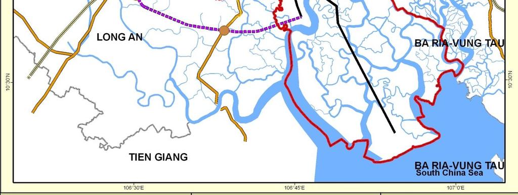
1 Populations effected by flood top ten districts 14 Extreme A2 Extreme A2 with dyke District Area (Ha) Population 2050 People affected Percent area affected People affected Percent area affected ,492,000 1,410, ,160, , , , , , , ,071,000 1,070, , , , , ,420,000 2,321, ,310, Binh Thanh , , , Nha Be , , , Can Gio , , , Binh Chanh ,483,000 1,342, ,232, Total/ average 9,835,000 8,378, ,935, Total/ average HCMC 19,345,000 11,914, ,178,


2 15 Transport master plan - roads


3 Transport master plan rail, ports and airport 16


4 Transport master plan and 2050 extreme flood 17
5 Risk indicator 0 km: Inundated <1 km: Very high risk <5 km: High risk <10km: Medium risk >10km: Low risk 2050 planned major road intersections at risk with and without the planned dyke system 18 Distance from flooded area (km) Main intersections Extreme A2 Extreme A2 with dyke National road no. 13 (Binh Phuoc intersection) Provincial road no Nga Tu Ga Provincial road no Provincial road no. 15 (Quang Trung inersection) National road no. 22 (An Suong intersection) South-Western new road Tan Tao - Cho Dem highway Provincial road no Hung Vuong (An Lac intersection) Nguyen Van Linh National road no Chanh Hung Nguyen Van Cu North-South Axis Intersection of A Area Inter-Provincial road no Inter-Provincial road no Hanoi highway (Binh Thai intersection) Saigon-Long Thanh-Dau Giay highway Saigon-Long Thanh-Dau Giay highway Tan Van intersection National road no. 1K National road no. 13 (Thu Dau Mot) Provincial road no National road no Provincial road no Provincial road no Saigon-Trung Luong highway National road no National road no. 1A (Ben Luc town, Long An) Saigon-Trung Luong highway New road (Provincial road no. 14 near Duc Hoa town National road no HCMC-Moc Bai highway National road no National road no. 1A (Trang Bom), km National road no Ring road no. 3 (Nhon Trach) North-South Axis Ring road no. 3 (Nhon Trach) Provincial road no

6 Existing and planned industrial zones in extreme 2050 flood without dyke system 19
7 Existing and planned industrial zones in extreme 2050 flood with dyke system 20
8 Risk indicator Name Izs and IPZs Type Distance from flooded area Extreme A2 Extreme A2 with dyke Hoc Mon Group Hiep Thanh IZ IZ Tan Thoi Nhat Group Tan Binh IZ IZ Vinh Loc I IZ IZ Tan Tao IZ IZ De Bo Metro Group Le Minh Xuan IZ IZ Xuan Thoi Son Group Xuan Thoi Thuong IZ IZ Vinh Loc II IZ IZ Nhat Thanh Group existing Thoi An Group Ba Diem Group and Dong Thanh IZ IZ planned Bau Dung IZ IZ West-North Cu Chi IZ IZ industrial Tan Phu Trung IZ IZ Bau Tran IZ Group zones in Phan Van Coi IZ Group extreme Phuoc Hiep IZ Group Tan Quy IZ Group Tan Tuc Group km: Inundated <1 km: Very high risk <5 km: High risk <10km: Medium risk >10km: Low risk 21 flood (i) without and (ii) with dyke system Phong Phu IZ IZ Tan Thuan IPZ IPZ Hiep Phuoc IZ IZ Quy Duc Group Hung Long Group Small enterprisez Group Cat Lai IZ IZ SaiGon Hi-Tech Park IZ Phu Huu IZ Linh Trung II IPZ Binh Chieu IZ IZ Da Phuoc Group Tan Thoi Hiep IZ` IZ

9 Water supply infrastruct ure - impact of 2050 flood 22


10 Water supply infrastructu re - impact of 2050 drought and saline intrusion 23


11 Agriculture and 4ppt saline intrusion during 2050 regular flood without dykes 24


12 Water treatment infrastructu re and land fill sites 25
13 Risk indicator 0 km: Inundated <1 km: Very high risk <5 km: High risk <10km: Medium risk >10km: Low risk Waste water treatment plants Area (ha) Capacity (m3/day) Regular flood A2 Distance from flood area(km) Extreme flood A2 Extreme flood A2 with control flood system Basin 1, THBNDT Basin 2, West HCMC Planned water treatment plants at risk with and without the dyke system 26 Basin 3,THLG Basin 4, South HCMC Basin 5, East HCMC Basin 6 North HCMC II Basin 7 North HCMC I Basin 8, Go Vap and Binh Thanh Basin 9, NLTN Basin 10, Nha Be Basin 11, Tac river, dist Basin 12, Ba Diem, Nga Ba Dong Basin 13, canal Hoc Mon, dist Hoc Mon Basin 14, Binh Tan and Binh Chanh Basin 15, canal Cau Dua, dist Hoc Mon Basin 16, Cu Chi
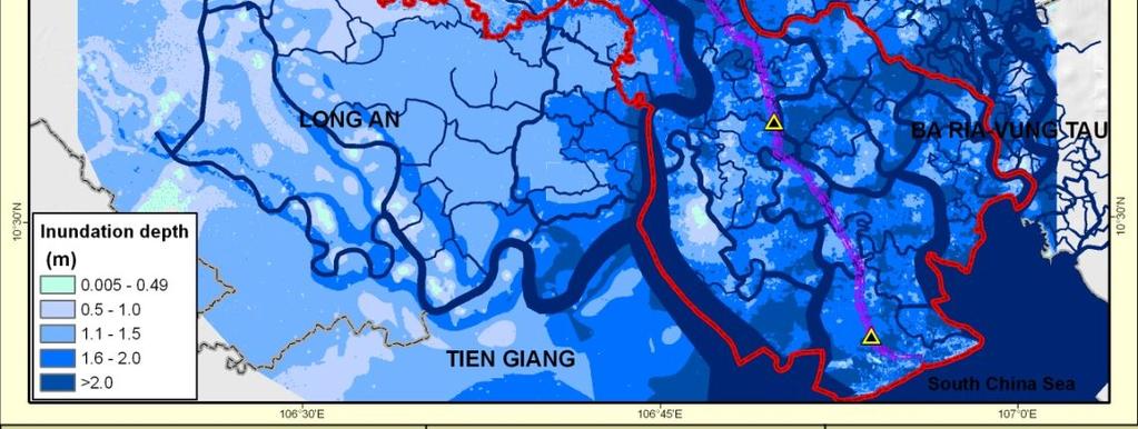
14 Some key potential risks 27 The impact of 2050 extreme and regular climate and hydrodynamic conditions on infrastructure could be extensive and far reaching in its effects on the City s economy. The transport master plan is committed to (i) major ring road construction, (ii) arterial interprovincial and national roads, and (iii) new ports and rail/metro systems. By 2050, some 30-70% of these new systems are at risk of flooding. Close to 70% of the City s remaining agriculture are at risk of salinity concentrations 4ppt Some 50% of the City s surface and ground water treatment plants are at risk of flooding and salinity of concentrations of 1ppt. 60% of the City s waste water treatment plants and 90% of land fill sites are at risk of flooding
15 Adaptation options 28 The aim to increase resilience in vulnerable communities, development sectors and areas Engineering options (eg dykes and drainage systems) Traditional local strategies Social responses (including resettlement and autonomous actions) Land use planning (eg zoning and development controls) Economic instruments (eg subsidies and tax incentives) Natural systems management (eg rehabilitation, enhancement) Sector specific adaptation practices (eg agriculture - species, regimes) Definition of associated institutional and administrative innovations
16 Integration of adaptation options Integration into overarching socio-economic and spatial and plans eg Socio-economic plan (DPI) Land use plan (DONRE) Urban Master Plan (DUPA) Construction plan (DOC) 2. Integration with sector development plans - Sector-wide adaptation policies and plans 3. Integration with Building Code and sector design standards and guidelines 4. Integrating through area specific adaptation guidelines and development controls
17 Guiding principles for HCMC adaptation Build on experience in natural disaster response 2. Rehabilitate and maintain and natural flexibility and resilience in City design 3. Promote autonomous responses amongst communities and sectors 4. Maintain and enhance natural systems 5. Maintain and enhance biodiversity for greater stability and resilience 6. Keep rivers and canals free flowing and clean 7. Ensure the poor are not worse off with climate change 8. Locate strategic infrastructure away from vulnerable areas 9. Locate sensitive industrial and commercial functions away from vulnerable areas 10. Facilitate adaptation at every level of government
18 Four approaches to integrating adaptation in development Adaptation auditing and retrofitting in existing and approved developments beginning with those in vulnerable areas 2. Integration of adaptation into future development planning for areas and sectors (requires guidance on adaptation options and hotspot profiling and assessments) 3. Assessing development plans and project proposals as they come through the planning pipeline against adaptation screening tools as part of Strategic Environmental Assessment and EIA 4. Monitoring and evaluation of implementation of adaptation measures and the opportunity and authority to require remedial and additional actions.
19 The example of water supply engineering retrofitting 32 All infrastructure is designed on current climate and sea level The key issues are flood levels and salinity intrusion Actions required on existing water supply infrastructure 1. Raising dry and wet well walls 2. Raising electricity control panels 3. Raising access roads 4. Raising reservoir walls 5. Move intakes upstream 6. Review and modify dykes systems in vicinity of infrastructure It is not if but when and by how much such retrofitting will be needed
20 Natural system adaptation 33 The flood protection dyke system phases - an opportunity to learn and adapt (exploring natural system options) The rehabilitation and extension of mangroves as a first line of defense from seaward climate River and canal bank rehabilitation the 40 m rule Reforestation and enhancement of City watersheds. The cleaning up of canals and rivers The protection and rehabilitation of urban wetlands. Promote different crops and trees for areas at risk of saline intrusion.
21 Actions required of HCMC PC 34 reform the existing natural disaster management committee into a climate change adaptation and mitigation committee prepare a HCMC climate change adaptation plan establish a climate change adaptation and mitigation fund provide special budgetary allocation for adaptation over a five year period to support
22 Actions required of DONRE 35 prepare the land use plan as a key instrument for promoting and implementing adaptation apply adaptation screening guidance for the review of sector and spatial plans, and introduce screening and assessment tools to the SEA and EIA process as another force for integration of adaptation in development planning.
23 Actions required of sectors 36 auditing existing infrastructure and development plans and orientations retrofitting adaptation measures in existing infrastructure, defining sector specific adaptation options reviewing and upgrading sector design standards (most prepared in the early 1990 s) Integrating adaptation measures into strategies and plans for the next development period, and introducing a system of monitoring, auditing and reporting on sector adaptation performance.
24 Lessons from experience 37 Adaptation needs to be placed in the context of development planning cycles Adaptation needs to be given a spatial planning context (eg local areas, provinces, catchments) Adaptation occurs at different levels regional, national and, in particular, the local level Adaptation occurs in sectors, communities and areas Local experience should be linked with national policy-making There is rich past experience in adaption to natural disasters to draw from
HCMC CLIMATE CHANGE IMPACT AND ADAPTATION ADB/HCMC PPC. Director ICEM International Centre for Environmental Management
 HCMC CLIMATE CHANGE IMPACT AND ADAPTATION STUDY ADB/HCMC PPC Jeremy Carew-Reid Jeremy Carew-Reid Director ICEM International Centre for Environmental Management Adaptation planning capacity 2 Increasing
Vietnam Coastal Erosion - Cause and Challenges -
 Administration of Sea and Islands Center for Oceanography University of Transport and Communications, Hanoi Vietnam Vietnam Coastal Erosion - Cause and Challenges - Presenters: Pham Hoang KIEN Le Van CONG
Current Status of Vietnam Coastal Erosion and Major Measures for Mitigation
 Vietnam Administration of Sea and Islands Center for Oceanography University of Transport and Communications Current Status of Vietnam Coastal Erosion and Major Measures for Mitigation Case Study: Thanh
Exploring the spatial-temporal linkages of climate response and rapid urban growth in Ho Chi Minh City
 Exploring the spatial-temporal linkages of climate response and rapid urban growth in Ho Chi Minh City 1 Introduction and Problem Overview In general, Asian cities located in deltaic regions tend to exhibit
Investigation, assessment and warning zonation for landslides in the mountainous regions of Vietnam
 Investigation, assessment and warning zonation for landslides in the mountainous regions of Vietnam (State-Funded Landslide Project SFLP) Dr. Eng. Le Quoc Hung Add: 67 Chien Thang Street, Ha Dong District,
Establishing the Method for Assessing Flood Vulnerability in Ho Chi Minh City, Vietnam A Case Study in District 6
 Journal of Environmental Science and Engineering B 7 (2018) 72-82 doi:10.17265/2162-5263/2018.02.005 D DAVID PUBLISHING Establishing the Method for Assessing Flood Vulnerability in Ho Chi Minh City, Vietnam
Hydraulic modelling for flood vulnerability assessment, case study in river basins in North Central Vietnam
 Hydraulic modelling for flood vulnerability assessment, case study in river basins in North Central Vietnam Tran Ngoc Anh 1*,2, Dang Dinh Kha 1,2, Dang Dinh Duc 2, Nguyen Thanh Son 1 1 Faculty of Hydrology
Huong River. Serial No. : Viet Nam-8 Location: Thua Thien Hue Province, Viet Nam N 16 00' '
 Viet Nam 8 Huong River Map of River Table of Basic Data Name: Huong River Serial No. : Viet Nam-8 Location: Thua Thien Hue Province, Viet Nam N 16 00' - 14 40' E 107 07' - 107 50' 2 Area: 2,830 km Length
Procurement Plan. 3. Reference to (if any) Project Operational/Procurement Manual: January 28, 2016.
 Project Operational/Procurement Manual: January 28, 2016.") Public Disclosure Authorized Public Disclosure Authorized Public Disclosure Authorized Public Disclosure Authorized I. General Plan 1. Bank s approval Date of the procurement Plan September 28, 2015 2.
Public Disclosure Authorized Public Disclosure Authorized Public Disclosure Authorized Public Disclosure Authorized I. General Plan 1. Bank s approval Date of the procurement Plan September 28, 2015 2.
SUPPLEMENTAL MATERIAL. Modulation of Daily Rainfall in Southern Vietnam by the Madden-Julian. Oscillation and Convectively Coupled Equatorial Waves
 SUPPLEMENTAL MATERIAL Modulation of Daily Rainfall in Southern Vietnam by the Madden-Julian Oscillation and Convectively Coupled Equatorial Waves Roderick van der Linden 1 Institute for Geophysics and
Implementation Status & Results Vietnam Danang Sustainable City Development Project (SCDP) (P123384)
 (P123384)") Public Disclosure Authorized Public Disclosure Authorized The World Bank Implementation Status & Results Vietnam Danang Sustainable City Development Project (SCDP) (P123384) Operation Name: Danang Sustainable
Public Disclosure Authorized Public Disclosure Authorized The World Bank Implementation Status & Results Vietnam Danang Sustainable City Development Project (SCDP) (P123384) Operation Name: Danang Sustainable
CAN THO URBAN DEVELOPMENT AND RESILIENCE PROJECT
 CAN THO URBAN DEVELOPMENT AND RESILIENCE PROJECT 1 Phnom Penh Can Tho City HCM City EAST SEA 2 1 3 Highest Water Level WATER LEVEL RAISE IN CAN THO DURING LAST 40 YEARS 4 2 Land subsidence a threat that
Impacts of climate change on the flow in Hong-Thai Binh and Dong Nai river basins
 VNU Journal of Science, Earth Sciences 27 (2011) 98-106 Impacts of climate change on the flow in Hong-Thai Binh and Dong Nai river basins Tran Hong Thai*, Tran Thuc Vietnam Institute of Meteorology, Hydrology
LESSONS FROM TYPHOON NARI
 LESSONS FROM TYPHOON NARI Storm Resistant Housing Shown To Be Effective Tran Van Giai Phong, Technical Lead ISET-Vietnam LESSONS FROM TYPHOON NARI 1 LESSONS FROM TYPHOON NARI Storm Resistant Housing Shown
Uses of The Climate and Climate-related Hazard Information in The Adaptation Strategies for Development and Spatial Planning Assessments
 Uses of The Climate and Climate-related Hazard Information in The Adaptation Strategies for Development and Spatial Planning Assessments Wilmar Salim, ST., M. Reg. Dev., Ph.D. Yogyakarta Monday, March
International Symposium on Natural Disaster Mitigation. Local vulnerability assessment of landslides and debris flows
 International Symposium on Natural Disaster Mitigation of landslides and debris flows Lessons learnt from Cam Pha town and Van Don district, Quang Ninh province, Vietnam Nguyen Quoc Phi Faculty of Environment
Satellite image-based quantitative assessment of surface urban heat island supporting environmental management at the city level
 Journal of Biodiversity and Environmental Sciences (JBES) ISSN: 2220-6663 (Print) 2222-3045 (Online) Vol. 10, No. 3, p. 224-234, 2017 http://www.innspub.net RESEARCH PAPER OPEN ACCESS Satellite image-based
E2993 v4. Background on Natural Disaster. Environmental Assessment (EA) Viet Nam Managing Natural Hazards Project (VN-Haz/WB5) ANNEX 4
 Viet Nam Managing Natural Hazards Project (VN-Haz/WB5) ANNEX 4") Public Disclosure Authorized Public Disclosure Authorized Public Disclosure Authorized Public Disclosure Authorized Environmental Assessment (EA) ANNEX 4 Background on Natural Disaster 1. This annex presents
Public Disclosure Authorized Public Disclosure Authorized Public Disclosure Authorized Public Disclosure Authorized Environmental Assessment (EA) ANNEX 4 Background on Natural Disaster 1. This annex presents
INTEGRATING CLIMATE VULNERABILITY & RISK ASSESSMENT INTO URBAN SPATIAL PLANNING PROCESS
 INTEGRATING CLIMATE VULNERABILITY & RISK ASSESSMENT INTO URBAN SPATIAL PLANNING PROCESS (CASE STUDY: BLITAR CITY, EAST JAVA, INDONESIA) SHINTA MICHIKO PUTERI, ST, MT. DR. IR. DENNY ZULKAIDI, MUP. WRITER
HEAVY RAIN OVER MID-CENTRAL REGION OF VIETNAM
 HEAVY RAIN OVER MID-CENTRAL REGION OF VIETNAM ----------------------------------------------------------------------- S.Eng. Dang Thi Mai; Dr. Nguyen Thi Tan Thanh National Hydro Meteorological Service
Assessment of climate change impacts on salinity intrusion in Hong-Thai Binh and Dong Nai river basins
 VNU Journal of Science, Earth Sciences 27 (2011) 54-61 Assessment of climate change impacts on salinity intrusion in Hong-Thai Binh and Dong Nai river basins Tran Hong Thai, Tran Thi Van* Vietnam Institute
 CLASSIFYING SMALL AREAS IN HANOI FO TitleLANSCAPE MANAGEMENT-BASED ON FACTOR CLUSTER ANALYSIS METHOD Author(s) Nguyen, Cao Huan; Nguyen, An Thinh; Sawaki, Masanori Annual Report of FY 2004, The Core Citation
International Guidelines on Access to Basic Services for All
 International Guidelines on Access to Basic Services for All Presentation and initials lessons from implementation Accessibility to services in regions and cities : measures and policies, OECD 18 June
Optical Remote Sensing Method for Detecting Urban Green Space as Indicator Serving City Sustainable Development
 Proceedings Optical Remote Sensing Method for Detecting Urban Green Space as Indicator Serving City Sustainable Development Tran Thi Van *, Nguyen Dang Huyen Tran, Ha Duong Xuan Bao, Dinh Thi Thanh Phuong,
THE MODEL OF SPATIAL ORGANIZATION OF COASTAL FISHERMEN VILLAGES IN THE SOUTH CENTRAL COAST OF VIETNAM
 i MINISTRY OF EDUCATION AND TRAINING MINISTRY OF CONSTRUCTION HANOI ARCHITECTURAL UNIVERSITY TRAN VAN HIEN THE MODEL OF SPATIAL ORGANIZATION OF COASTAL FISHERMEN VILLAGES IN THE SOUTH CENTRAL COAST OF
Proposal for Research and Investment Activities in the Coast and Estuaries (A Case Study in the North Central Coast of Viet Nam)
") 2017/SOM3/EPWG/019 Agenda Item: 7.2.3 Proposal for Research and Investment Activities in the Coast and Estuaries (A Case Study in the North Central Coast of Viet Nam) Purpose: Information Submitted by:
2017/SOM3/EPWG/019 Agenda Item: 7.2.3 Proposal for Research and Investment Activities in the Coast and Estuaries (A Case Study in the North Central Coast of Viet Nam) Purpose: Information Submitted by:
CHAPTER 4 HIGH LEVEL SPATIAL DEVELOPMENT FRAMEWORK (SDF) Page 95
 Page 95") CHAPTER 4 HIGH LEVEL SPATIAL DEVELOPMENT FRAMEWORK (SDF) Page 95 CHAPTER 4 HIGH LEVEL SPATIAL DEVELOPMENT FRAMEWORK 4.1 INTRODUCTION This chapter provides a high level overview of George Municipality s
CHAPTER 4 HIGH LEVEL SPATIAL DEVELOPMENT FRAMEWORK (SDF) Page 95 CHAPTER 4 HIGH LEVEL SPATIAL DEVELOPMENT FRAMEWORK 4.1 INTRODUCTION This chapter provides a high level overview of George Municipality s
Use of Geospatial data for disaster managements
 Use of Geospatial data for disaster managements Source: http://alertsystemsgroup.com Instructor : Professor Dr. Yuji Murayama Teaching Assistant : Manjula Ranagalage What is GIS? A powerful set of tools
Implementation Status & Results Vietnam Second Northern Mountains Poverty Reduction Project (P113493)
") Public Disclosure Authorized Public Disclosure Authorized The World Bank Implementation Status & Results Vietnam Second Northern Mountains Poverty Reduction Project (P113493) Operation Name: Second Northern
Public Disclosure Authorized Public Disclosure Authorized The World Bank Implementation Status & Results Vietnam Second Northern Mountains Poverty Reduction Project (P113493) Operation Name: Second Northern
Megacity Research Project TP. Ho Chi Minh Adaptation to Global Climate Change in Vietnam: Integrative Urban and Environmental Planning Framework
 1. Organization 2. Global Warming 3. Starting Phase 4. Results, Transdisciplinarity, Low-Rise High Density 5. Risk of Flooding 6. Partners 7. Action Field 1 8. Action Field 2 9. Urban Development Trends
VNREDSat-1. Vietnam Natural Resources, Environment and Disaster monitoring Satellite. Lai Anh Khoi SPACE TECHNOLOGY INSTITUTE
 VNREDSat-1 Vietnam Natural Resources, Environment and Disaster monitoring Satellite Lai Anh Khoi SPACE TECHNOLOGY INSTITUTE JPTM2014 Yangon, Nov. 19-21, 2014 General information (1) Project Owner: Vietnam
ME KONG RIVER COMMISSION FLASH FLOOD GUIDANCE SYSTEM (MRCFFGS)
") NATIONAL HYDRO-METEOROLOGICAL SERVICE IN VIETNAM NATIONAL CENTER FOR HYDRO-METEOROLOGICAL FORECASTING ME KONG RIVER COMMISSION FLASH FLOOD GUIDANCE SYSTEM (MRCFFGS) http://www.nchmf.gov.vn 29 Nov 1 Dec
NATIONAL HYDRO-METEOROLOGICAL SERVICE IN VIETNAM NATIONAL CENTER FOR HYDRO-METEOROLOGICAL FORECASTING ME KONG RIVER COMMISSION FLASH FLOOD GUIDANCE SYSTEM (MRCFFGS) http://www.nchmf.gov.vn 29 Nov 1 Dec
Opportunities and challenges of HCMC in the process of development
 Opportunities and challenges of HCMC in the process of development Lê Văn Thành HIDS HCMC, Sept. 16-17, 2009 Contents The city starting point Achievement and difficulties Development perspective and goals
Measuring Disaster Risk for Urban areas in Asia-Pacific
 Measuring Disaster Risk for Urban areas in Asia-Pacific Acknowledgement: Trevor Clifford, Intl Consultant 1 SDG 11 Make cities and human settlements inclusive, safe, resilient and sustainable 11.1: By
The Governance of Land Use
 The planning system Levels of government and their responsibilities The Governance of Land Use COUNTRY FACT SHEET NORWAY Norway is a unitary state with three levels of government; the national level, 19
The World Bank Cities and Climate Change (P123201)
") Public Disclosure Authorized AFRICA Mozambique Social, Urban, Rural and Resilience Global Practice Global Practice IBRD/IDA Investment Project Financing FY 2012 Seq No: 13 ARCHIVED on 17-May-2018 ISR31517
Public Disclosure Authorized AFRICA Mozambique Social, Urban, Rural and Resilience Global Practice Global Practice IBRD/IDA Investment Project Financing FY 2012 Seq No: 13 ARCHIVED on 17-May-2018 ISR31517
Proceeding Optical Remote Sensing Method for Detecting Urban Green Space as Indicator Serving City Sustainable Development
 Proceeding Optical Remote Sensing Method for Detecting Urban Green Space as Indicator Serving City Sustainable Development Tran Thi Van *, Nguyen Dang Huyen Tran, Ha Duong Xuan Bao, Dinh Thi Thanh Phuong,
Cities and Climate Change (P123201)
") Public Disclosure Authorized AFRICA Mozambique Social, Urban, Rural and Resilience Global Practice Global Practice IBRD/IDA Investment Project Financing FY 2012 Seq No: 14 ARCHIVED on 04-Nov-2018 ISR33750
Public Disclosure Authorized AFRICA Mozambique Social, Urban, Rural and Resilience Global Practice Global Practice IBRD/IDA Investment Project Financing FY 2012 Seq No: 14 ARCHIVED on 04-Nov-2018 ISR33750
2014 Summer training course for slope land disaster reduction Taipei, Taiwan, Aug
 MINISTRY OF SCIENCE AND TECHNOLOGY HYDROTECH RESEARCH INSTITUTE MINISTRY OF NATURAL RESOURCES AND ENVIRONMENT VIETNAM INSTITUTE OF GEOSCIENCES AND MINERAL RESOURCES (VIGMR) 2014 Summer training course
Coastal urban climate resilience planning in Quy Nhon, Vietnam
 Asian Cities Climate Resilience WoRKING PAPER SERIES 15: 2015 Coastal urban climate resilience planning in Quy Nhon, Vietnam By VU KIm CHI, NGUyEN THI THUy HANG, DINH THI BAo HoA, LUoNG THI VAN, NGUyEN
The World Bank. Key Dates. Project Development Objectives. Components. Public Disclosure Authorized. Implementation Status & Results Report
 Public Disclosure Authorized EAST ASIA AND PACIFIC Vietnam Transport & ICT Global Practice IBRD/IDA Specific Investment Loan FY 2008 Seq No: 16 ARCHIVED on 28-Dec-2016 ISR26429 Implementing Agencies: Hanoi
Nguyen Hoang Khanh Linh, Le Ngoc Phuong Quy, Truong Do Minh Phuong and Nguyen Trac Ba An
 Journal of Agricultural Science and Technology A and B & Hue University Journal of Science 7 (2017) 48-59 doi: 10.17265/2161-6256/2017.10.007S D DAVID PUBLISHING Application of Remote Sensing and GIS Technology
Team 09 Nguyen chau lan (Vietnam) Dilum Wannigasekara (Sri lanka)
 Dilum Wannigasekara (Sri lanka)") Team 09 Nguyen chau lan (Vietnam) Dilum Wannigasekara (Sri lanka) contents Part I: Landslide in Vietnam Part II: Case study of Landslide in sri lanka Part I: Introduction of Landslide in hoa binh province
Team 09 Nguyen chau lan (Vietnam) Dilum Wannigasekara (Sri lanka) contents Part I: Landslide in Vietnam Part II: Case study of Landslide in sri lanka Part I: Introduction of Landslide in hoa binh province
Storm Surge/Coastal Inundation State of the Union. Jamie Rhome Storm Surge Team Lead NOAA/National Hurricane Center
 Storm Surge/Coastal Inundation State of the Union Jamie Rhome Storm Surge Team Lead NOAA/National Hurricane Center 2 Tampa: Cat 5 Scenario 3 4 The Stakes are High Combination of SLR and increasing coastal
Delta Flood Protection Strategy Update. May 16, 2016
 Delta Flood Protection Strategy Update May 16, 2016 Presentation Overview 1. Background 2. Understanding the Dike Reaches/Issues 3. Future Dike Improvements 4. Next Steps Boundary Bay Village March 10,
The Governance of Land Use
 The planning system The Governance of Land Use United Kingdom Levels of government and their responsibilities The United Kingdom is a unitary state with three devolved governments in Northern Ireland,
KHI X L T SÔNG H NG VÀO SÔNG ÁY
 XÂY D NG B N NG P L T KHU V C H DU TÓM T T T KHI X L T SÔNG H NG VÀO SÔNG ÁY Lê Vi t S n 1 Bài báo này trình bày k t qu nghiên c u, ánh giá r i ro ng p l vùng h du sông áy khi x l t sông H ng vào sông
Summary. Recommendations on the Fifth Policy Document on Spatial Planning September 2001
 Summary Recommendations on the Fifth Policy Document on Spatial Planning September 2001 2 Introduction In December 2000 the Dutch Cabinet issued Part 1 of the Fifth National Policy Document on Spatial
Climate Change Impact on Intensity-Duration- Frequency Curves in Ho Chi Minh city
 Climate Change Impact on Intensity-Duration- Frequency Curves in Ho Chi Minh city Khiem Van Mai, Minh Truong Ha, Linh Nhat Luu Institute of Meteorology, Hydrology and Climate Change, Hanoi, Vietnam Hanoi,
Updating a medium-scale landslide database for high-risk areas using community surveys in Vietnam
 On-going program of the State-Funded Landslide Project (SFLP): Updating a medium-scale landslide database for high-risk areas using community surveys in Vietnam Coordinated by: Le Quoc Hung, Pham Van Son,
Monitoring Urban Space Expansion Using Remote Sensing Data in Ha Long City, Quang Ninh Province in Vietnam
 Monitoring Urban Space Expansion Using Remote Sensing Data in Ha Long City, Quang Ninh Province in Vietnam MY Vo Chi, LAN Pham Thi, SON Tong Si, Viet Key words: VSW index, urban expansion, supervised classification.
MOZAMBIQUE: Institutional Arrangements and Achievements
 UN-International Strategy for Disaster Reduction Global Platform for Disaster Risk Reduction- First Session MOZAMBIQUE: Institutional Arrangements and Achievements on Implementation of Hyogo Framework
SÁNG TH T, NGÀY
 4 SÁNG TH T, NGÀY 23.4.2008 07h00 08h30 Xe a i bi u t Vi n Toán h c lên Ba Vì 8h30 09h00 ón ti p i bi u t i Ba Vì 09h00 09h15 Khai m c H i th o 09h15 10h15 Ch t a: Hoàng Xuân Phú Hoàng T y (Bài gi ng m
Analyzing spatial and temporal variation of water balance components in La Vi catchment, Binh Dinh province, Vietnam
 Analyzing spatial and temporal variation of water balance components in La Vi catchment, Binh Dinh province, Vietnam Nguyen Duy Liem, Vo Ngoc Quynh Tram, Nguyen Le Tan Dat, Nguyen Kim Loi Nong Lam University-
TOWARDS CLIMATE-RESILIENT COASTAL MANAGEMENT: OPPORTUNITIES FOR IMPROVED ICZM IN BELIZE
 TOWARDS CLIMATE-RESILIENT COASTAL MANAGEMENT: OPPORTUNITIES FOR IMPROVED ICZM IN BELIZE CHANTALLE SAMUELS Coastal Zone Management Authority and Institute The Caribbean Community Climate Change Centre VULNERABILITY
hoctoancapba.com Kho đ ề thi THPT quốc gia, đ ề kiểm tra có đáp án, tài liệu ôn thi đại học môn toán
 hoctoncpb.com xin giới thiệu Tuyển chọn các bài ÌN Ọ KÔNG GIN trong 1 Đ Ề TI T Ử TÂY NIN 15 y vọng tài liệu này s ẽ giúp các em học sinh ôn tập tốt hơn chuyên đề ÌN Ọ KÔNG GIN trong k ỳ thi TPT QG sắp
Overview of proposed approach to the Desktop Study to inform discussion
 LTAS Phase 2: Climate Change Implications for the Human Settlements sector in South Africa Overview of proposed approach to the Desktop Study to inform discussion Project Team Project Lead: Crispian Olver
Natura 2000 and spatial planning. Executive summary
 Natura 2000 and spatial planning Executive summary DISCLAIMER The information and views set out in this study are those of the author(s) and do not necessarily reflect the official opinion of the Commission.
TOOLS FOR RISK MANAGEMENT Related to climate change
 TOOLS FOR RISK MANAGEMENT Related to climate change copyright CONTENT 1 CLIMATE CHANGE AND ENVIRONMENTAL STUDIES 2 METHODS AND TOOLS DEVELOPED BY EGIS For infrastructures For urban areas For crisis management
SESSION C: OPTICS, LASER AND APPLICATIONS November 27, 2012 (Thuesday)
") SESSION C: OPTICS, LASER AND APPLICATIONS November 27, 2012 (Thuesday) Chairperson: Prof. Dr. Tran Ba Chu (Academy of Military Sci. & Tech, Hanoi) Dr. Nguyen Huy Bang (Vinh University) (C-01) 13:30 13:55
SESSION C: OPTICS, LASER AND APPLICATIONS November 27, 2012 (Thuesday) Chairperson: Prof. Dr. Tran Ba Chu (Academy of Military Sci. & Tech, Hanoi) Dr. Nguyen Huy Bang (Vinh University) (C-01) 13:30 13:55
Urban Climate Resilience
 Urban Climate Resilience in Southeast Asia Partnership Project Introduction Planning for climate change is a daunting challenge for governments in the Mekong Region. Limited capacity at the municipal level,
EVALUATION OF THE VULNERABILITY OF TitleCOASTAL SOCIO-NATURAL SYSTEMS (EXAM FROM KHANH HOA COASTAL ZONE) Author(s) Nguyen, Thi Thuy Hang; Pham, Hung T
 Author(s) Nguyen, Thi Thuy Hang; Pham, Hung T") EVALUATION OF THE VULNERABILITY OF TitleCOASTAL SOCIO-NATURAL SYSTEMS (EXAM FROM KHANH HOA COASTAL ZONE) Author(s) Mai, Trong Nhuan; Tran, Thanh Hai; Nguyen, Thi Thuy Hang; Pham, Hung T Annual Report of
EVALUATION OF THE VULNERABILITY OF TitleCOASTAL SOCIO-NATURAL SYSTEMS (EXAM FROM KHANH HOA COASTAL ZONE) Author(s) Mai, Trong Nhuan; Tran, Thanh Hai; Nguyen, Thi Thuy Hang; Pham, Hung T Annual Report of
PROMOTING NATURE CONSERVATION AND SUSTAINABLE AGRICULTURAL DEVELOPMENT IN THE RURAL AREAS OF HONG KONG
 1 PROMOTING NATURE CONSERVATION AND SUSTAINABLE AGRICULTURAL DEVELOPMENT IN THE RURAL AREAS OF HONG KONG Director of Agriculture, Fisheries and Conservation Dr. LEUNG Siu-fai A STONE S THROW AWAY FROM
Together towards a Sustainable Urban Agenda
 Together towards a Sustainable Urban Agenda The City We (Youth) Want Preliminary findings from youth consultations Areas Issue Papers Policy Units 1.Social Cohesion and Equity - Livable Cities 2.Urban
Background and History
 p1 Background and History What is the Indian Ocean Climate Initiative? The Indian Ocean Climate Initiative (IOCI) is a strategic program of research and information transfer to support government decision-making.
Georeferencing and Satellite Image Support: Lessons learned, Challenges and Opportunities
 Georeferencing and Satellite Image Support: Lessons learned, Challenges and Opportunities Shirish Ravan shirish.ravan@unoosa.org UN-SPIDER United Nations Office for Outer Space Affairs (UNOOSA) UN-SPIDER
Recent development of the National Hydro-Meteorological Service (NHMS) of Viet Nam for disaster risk reduction
 of Viet Nam for disaster risk reduction") Ministry of Natural Resources and Environment National Hydro-Meteorological Service Recent development of the National Hydro-Meteorological Service (NHMS) of Viet Nam for disaster risk reduction Tran Van
Ministry of Natural Resources and Environment National Hydro-Meteorological Service Recent development of the National Hydro-Meteorological Service (NHMS) of Viet Nam for disaster risk reduction Tran Van
SPLAN-Natura Towards an integrated spatial planning approach for Natura th January, 2017 Brussels. Commissioned by DG Environment
 SPLAN-Natura 2000 Towards an integrated spatial planning approach for Natura 2000 Commissioned by DG Environment 17 th January, 2017 Brussels V. Simeonova (Ph.D.) Drivers towards integrating Biodiversity
Supporting Strategic Plan Development in Flanders
 Supporting Strategic Plan Development in Flanders Guy Engelen, Inge Uljee, Anne Gobin, Leen Van Esch, Hans van der Kwast VITO Flemish Institute for Technological Research Boeretang 200 2400 Mol Belgium
PURR: POTENTIAL OF RURAL REGIONS UK ESPON WORKSHOP Newcastle 23 rd November Neil Adams
 PURR: POTENTIAL OF RURAL REGIONS UK ESPON WORKSHOP Newcastle 23 rd November 2012 Neil Adams PURR: Potential of Rural Regions Introduction Context for the project A spectrum of knowledge Rural Potentials
Applying ArcGIS Online for Establishing Hanoi Agriculture Map
 Applying ArcGIS Online for Establishing Hanoi Agriculture Map Thanh Xuan Nguyen Geography Department Hanoi National University of Education mrthanhxuan@gmail.com Tien Yin Chou GIS Research Center Feng
CERTIFIED RESOLUTION. introduction: and dated May 29, 2017, as attached, as appropriate
 15322 Buena Vista Avenue, White Rock BC, Canada V4B 1Y6 www.whiterockcity.ca City of White Rock P: 604.541.22121 F: 604.541.9348 /2tC% City Clerk s Office IT E ROC K June 13,2017 Stephanie Lam, Deputy
16540/14 EE/cm 1 DG E 1A
 Council of the European Union Brussels, 5 December 2014 (OR. en) 16540/14 ENV 965 CULT 139 NOTE From: To: Subject: General Secretariat of the Council Delegations Charter of Rome on Natural and Cultural
ENSURE. Coordinator: Hormoz MODARESSI Website:
 ENSURE Coordinator: Hormoz MODARESSI h.modaressi@brgm.fr Website: http://ensureproject.eu/ The project is financed by the European Commission under the 7th Framework Programme for Research and Technological
TOWARDS STRATEGIC SPATIAL PLANNING IN JAMAICA: THE NATIONAL SPATIAL PLAN
 TOWARDS STRATEGIC SPATIAL PLANNING IN JAMAICA: THE NATIONAL SPATIAL PLAN JIEP 5th Biennial Conference on the Environment: Balancing National Development and Environmental Protection June 6, 2011 Jamaica
Port Cities Conference: How Regional Planning can Help Support a Competitive Port. Christina DeMarco Metro Vancouver
 Port Cities Conference: How Regional Planning can Help Support a Competitive Port Christina DeMarco Metro Vancouver June 12. 2008 Metro Vancouver Regional Growth Management Three ways to help support the
Tackling urban sprawl: towards a compact model of cities? David Ludlow University of the West of England (UWE) 19 June 2014
 19 June 2014") Tackling urban sprawl: towards a compact model of cities? David Ludlow University of the West of England (UWE) 19 June 2014 Impacts on Natural & Protected Areas why sprawl matters? Sprawl creates environmental,
Tackling urban sprawl: towards a compact model of cities? David Ludlow University of the West of England (UWE) 19 June 2014 Impacts on Natural & Protected Areas why sprawl matters? Sprawl creates environmental,
Urban Development (September 20, 2018)
") Urban Development (September 20, 2018) Town and Country Development Bureau Department of Public Works and Town & Country Planning Ministry of Interior, Thailand Brief Introduction of URBAN DEVELOPMENT
Urban Development (September 20, 2018) Town and Country Development Bureau Department of Public Works and Town & Country Planning Ministry of Interior, Thailand Brief Introduction of URBAN DEVELOPMENT
CHAPTER 6 CLIMATE AND CLIMATE - RELATED DISASTER PROFILE OF HA TINH
 CHAPTER 6 CLIMATE AND CLIMATE - RELATED DISASTER PROFILE OF HA TINH 6.1. Introduction This Chapter provides background climatic data for Ha Tinh, as a prelude to the climate change scenarios and vulnerability
Dar es Salaam - Reality Check Workshop
 Dar es Salaam - Reality Check Workshop hosted by GIZ and Dar es Salaam City Council Introduction: Key Urban Characteristics of Dar es Salaam Challenges and Opportunities for Resilient Development in the
IRRIGATION REHABILITATION PROGRAM 2014/2015
 IRRIGATION REHABILITATION PROGRAM 2014/2015 STATUS REPORT Prepared by Irrigation Secretariat Lethbridge, Alberta May 2016 ACKNOWLEDGEMENTS Gerald Ontkean of Alberta Agriculture and Forestry s Basin Water
Land Use in the context of sustainable, smart and inclusive growth
 Land Use in the context of sustainable, smart and inclusive growth François Salgé Ministry of sustainable development France facilitator EUROGI vice president AFIGéO board member 1 Introduction e-content+
SUPPORTS SUSTAINABLE GROWTH
 DDSS BBUUN NDDLLEE G E O S P AT I A L G O V E R N A N C E P A C K A G E SUPPORTS SUSTAINABLE GROWTH www.digitalglobe.com BRISBANE, AUSTRALIA WORLDVIEW-3 30 CM International Civil Government Programs US
DETERMINE OF REGIONAL DEVELOPMENT STRATEGIES IN IZMIR
 Sukran Yalpir Asli Bozdag Saban Inam DETERMINE OF REGIONAL DEVELOPMENT STRATEGIES IN IZMIR Globalization INTRODUCTION Economic pressure cause Economic migration cause cause Spatial organizations Spatial
HỘI NGHỊ QUANG HỌC QUANG PHỔ TOÀN QUỐC LẦN THỨ 10 ( HNQHQP-10) Hall C. November 12, 2018 (Monday)
 Hall C. November 12, 2018 (Monday)") HỘI NGHỊ QUANG HỌC QUANG PHỔ TOÀN QUỐC LẦN THỨ 10 ( HNQHQP-10) Hall C November 12, 2018 (Monday) Prof. Nguyen Manh An (Hong Duc Uni., Thanh Hoa) Dr. Pham Hong Minh (IOP, VAST, Ha Noi) (C-01) 13:30 13:55
HỘI NGHỊ QUANG HỌC QUANG PHỔ TOÀN QUỐC LẦN THỨ 10 ( HNQHQP-10) Hall C November 12, 2018 (Monday) Prof. Nguyen Manh An (Hong Duc Uni., Thanh Hoa) Dr. Pham Hong Minh (IOP, VAST, Ha Noi) (C-01) 13:30 13:55
Using Reanalysis SST Data for Establishing Extreme Drought and Rainfall Predicting Schemes in the Southern Central Vietnam
 Using Reanalysis SST Data for Establishing Extreme Drought and Rainfall Predicting Schemes in the Southern Central Vietnam Dr. Nguyen Duc Hau 1, Dr. Nguyen Thi Minh Phuong 2 National Center For Hydrometeorological
Impacts of Climate Change and Water-Related Disaster Reduction Management in the Asia-Pacific Region
 Impacts of Climate Change and Water-Related Disaster Reduction Management in the Asia-Pacific Region Katumi MUSIAKE Professor, Fukushima University Secretary General, Asia Pacific Association of Hydrology
Rencontres de Hanoï The Amendment to Hanoi Capital Regional Plan:
 Rencontres de Hanoï The Amendment to Hanoi Capital Regional Plan: Resuming working ties with Vietnamese urban planning authorities after 20 years of absence The Institut d Aménagement et d Urbanisme d
An introduction to thee Urban Oases Site Selection Tool:
 An introduction to thee Urban Oases Site Selection Tool: Created by Audubon Connecticut with assistance from a GIS Consultant/Research Assistant at the Harvard Forest Essential input provided by the New
The World Bank Metro Colombo Urban Development Project (P122735)
") Public Disclosure Authorized SOUTH ASIA Sri Lanka Social, Urban, Rural and Resilience Global Practice Global Practice IBRD/IDA Specific Investment Loan FY 2012 Seq No: 9 ARCHIVED on 11-Jul-2016 ISR23437
Public Disclosure Authorized SOUTH ASIA Sri Lanka Social, Urban, Rural and Resilience Global Practice Global Practice IBRD/IDA Specific Investment Loan FY 2012 Seq No: 9 ARCHIVED on 11-Jul-2016 ISR23437
Disaster Risk Reduction and
 6 th ICRM Symposium 2015 Disaster Risk Reduction and 2015/04/23 Resilience in Taipei Outline Natural Disaster and Loss in Taiwan Climate Change and Geohazard Hazard Alert & App Monitoring & Modeling Land
CLIMATE CHANGE IN VIET NAM: Observed and Future Projection
 2017 ACTS Workshop on Extreme Weather Forecast and Water Resources Management CLIMATE CHANGE IN VIET NAM: Observed and Future Projection Mai Van KHIEM Viet Nam Institute of Meteorology, Hydrology and Climate
The UN-GGIM: Europe core data initiative to encourage Geographic information supporting Sustainable Development Goals Dominique Laurent, France
 INSPIRE conference Strasbourg 6 September 2017 The UN-GGIM: Europe core data initiative to encourage Geographic information supporting Sustainable Development Goals Dominique Laurent, France Introduction
COSTA RICA Limon City-Port Project
 photos by Stefania Abakerli COSTA RICA Limon City-Port Project 2008 2013 Cecilia Corvalan William Reuben Stefania Abakerli Background Request from GoCR following Caldera-Port Concession Reform Since the
Linking the value of ocean space and marine ecosystem to coastal reclamation planning: A case study of Xiamen
 Linking the value of ocean space and marine ecosystem to coastal reclamation planning: A case study of Xiamen Benrong Peng, PhD Coastal and Ocean Management Institute, Xiamen University (COMI) Nov. 20,
SOCIO-ECONOMIC IMPACTS OF FLOODING IN DIRE DAWA, ETHIOPIA
 SOCIO-ECONOMIC IMPACTS OF FLOODING IN DIRE DAWA, ETHIOPIA Alemu Yonas Tadesse * Supervisor: Prof. A.W. Jayawardena ** MEE08182 ABSTRACT Dire Dawa, the second largest city of Ethiopia, has been suffering
Training Needs Assessment for Provincial and District Staff on Forecast Products and Early Warning Information
 Strengthening Capacities to Enhance Coordinated and Integrated Disaster Risk Reduction Actions and Adaptation to Climate Change in Agriculture in the Northern Mountain Regions of Viet Nam Training Needs
Towards a fully integrated urban weather environment climate service in Mexico City
 Towards a fully integrated urban weather environment climate service in Mexico City Mexico City Ministry of Environment SEDEMA Tanya Müller (Secretary of Environment), Beatriz Cárdenas (SEDEMA), Luisa
Presentation by Thangavel Palanivel Senior Strategic Advisor and Chief Economist UNDP Regional Bureau for Asia-Pacific
 Presentation by Thangavel Palanivel Senior Strategic Advisor and Chief Economist UNDP Regional Bureau for Asia-Pacific The High-Level Euro-Asia Regional Meeting on Improving Cooperation on Transit, Trade
Urbanization and Sustainable Development of Cities: A Ready Engine to Promote Economic Growth and Cooperation
 Urbanization and Sustainable Development of Cities: A Ready Engine to Promote Economic Growth and Cooperation Wan Portia Hamzah Institute of Strategic and International Studies (ISIS) Malaysia 10 September