Delta Flood Protection Strategy Update. May 16, 2016
|
|
|
- George Elliott
- 5 years ago
- Views:
Transcription


1 Delta Flood Protection Strategy Update May 16, 2016


2 Presentation Overview 1. Background 2. Understanding the Dike Reaches/Issues 3. Future Dike Improvements 4. Next Steps


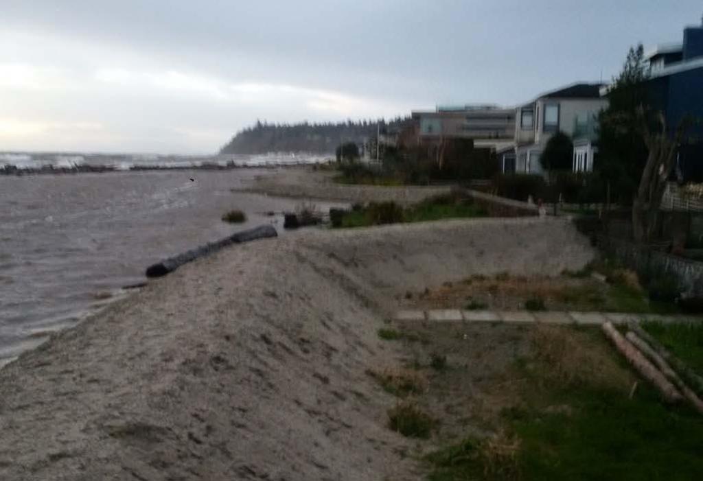
3 Boundary Bay Village March 10, 2016

4 East Delta Dike March 10, 2016

 Since 2000 Delta with Provincial and Federal funding has spent more")
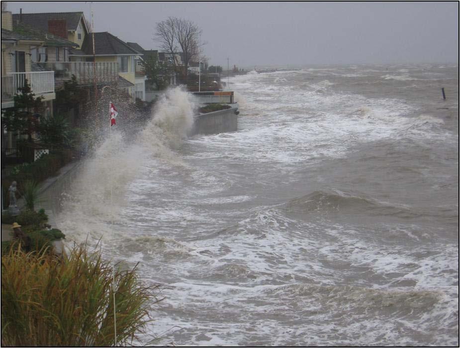
5 1. Background 1.1 Delta River & Sea Dikes Dikes are essential to protect: > $6.5 billion of land and infrastructure, Agricultural land Ladner (major dike breach could cause $1-$3 billion in damage, annual B/C ratio 2.5:1 over 50 yrs B/C >100:1 ) Since 2000 Delta with Provincial and Federal funding has spent more than $10 million on dike works, drainage pump stations, and floodbox repairs.
6 1.2 Provincial Guidelines Coastal Sea Level Rise Sea Dike Guidelines o Local governments should develop a locally appropriate long term flood protection strategy Seismic Design Guidelines o Dike upgrades requiring Dike Maintenance Act approval need a seismic assessment. (Important to do upfront, could change dike alignments.) Flood Hazard Area Land Use Management Guidelines Draft Amendments for Sections 3.5 & 3.6 o Proposed land use guideline amendments will require that land use planning in coastal areas considers sea level rise (2100 and 2200).
7 2. Understanding the Dike Reaches/Issues Coastal vs. River Dikes Foreshore Protection Provincial Regulatory Considerations o Sea Level Rise (Land Use Mgmt Guidelines, Sea Dike Guidelines) o Dike Seismic Stability Assessment

8 2.1 Delta River & Sea Dikes G F H I J A Dike Reaches A. East Delta Dike B. Beach Grove Seawall C. Boundary Bay Village D. Tsawwassen Beach E. Tsawwassen First Nation F. Brunswick Point G. Westham Island H. River Road West/Ladner I. Tilbury River Road East J. Annacis Island E B Dike Location Dike Elev. 3.5 m D C
")
9 2.2 Sea Level Rise Median sealevel rise of o 0.3m-0.5m by 2050 o 1.0m+0.2m by 2100 o Flood frequency will increase (i.e. increasing risk of dike overtopping)
10 3. Flood Protection Improvements 3.1 Update Development Policy 3.2 Dike Improvements / Upgrades
11 3.1 Update Development Policy Dike Elevation for New Developments Update Flood Protection Policy Meet future dike hieght requirements, Review Flood Construction Levels Review Official Community Plan Development Permit Areas for flood protection and report back
12 3.2 Dike Improvements / Upgrades Dike Seismic and Elevation Studies Phased Dike Upgrading / (Excavation fill program) Long Term & Sustainable Funding Program Ongoing Monitoring of Sea Level Rise
13 Dike Seismic and Elevation Studies Undertake a comprehensive seismic study for Delta dikes Dike Maintenance Approval requires that dike upgrades address seismic stability New developments adjacent to dikes to meet seismic requirements Foreshore/water level analysis

14 Phased Dike Upgrading (35 year Program) Flood Protection Levels to 2050 and 2100 Dike Height (m) Dike Reach Adapted From - Cost of Adaptation-Sea Dikes and Alternate Strategies -Oct 2012 Ministry of Forest Lands and Natural Resource Operations
15 Phased Dike Upgrading (35 yr Program) cont d Planning / dike upgrade fund for 67 km of dikes October 2012 Cost of Adaptation study by Province estimated 2100 dike upgrade cost for Delta $1.9 billion Phased program with Phase 1 upgrade to 2050 (i.e. over 35 years) preliminary costs estimated at more than $350 million (preliminary planning/studies, land/srws, managed construction in phases) excluding extensive seismic upgrading


16 Phased Dike Upgrading cont d Assess foreshore protection improvements Evaluate options for protecting the access to Ladner harbour, and improving flood protection for downtown Ladner. Commence a phase of flood protection works (based on the 2050 observed and predicted sea level rise)
17 Long Term and Sustainable Funding Program Conduct a more detailed assessment of upgrades and costs, after seismic studies. Work with the Finance Department to develop dedicated funding for a long term dike upgrading program. o. (eg. 1/3 share of a Municipal/Provincial/Federal cost shared program, dike levy for Municipal share) Participation in the Regional Flood Protection Studies and funding model development. Solicit senior government cost sharing support. (e.g. Federal, Provincial, Port Metro Vancouver)


18 Ongoing Monitoring of Sea Level Rise Sea Level Rise Monitoring Coastal Land Monitoring Participate in Regional Flood Protection Studies

19 4. Next Steps Review internal and external stakeholders (Interest Groups, Advisory Committees) Business Plan Workshop funding discussion Future Dike planning studies: Dike Elevation and Seismic Studies Water Level/Foreshore/ Flood Construction Level Studies. Commence planning for a filling/dike raising program. Ongoing work to address existing deficiencies.
20 Questions
21
Date: June 19, 2013 Meeting Date: July 5, Consideration of the City of Vancouver s Regional Context Statement
 Section E 1.5 To: From: Regional Planning and Agriculture Committee Lee-Ann Garnett, Senior Regional Planner Planning, Policy and Environment Department Date: June 19, 2013 Meeting Date: July 5, 2013 Subject:
What the. Just happened? THOMPSON WATERSHED DISASTER MITIGATION COMMUNITY FORUM FEBRUARY 14, 2018 Dwayne Meredith, P.Ag.
 What the Just happened? THOMPSON WATERSHED DISASTER MITIGATION COMMUNITY FORUM FEBRUARY 14, 2018 Dwayne Meredith, P.Ag. Agenda Historic context and recent events Policy and scientific information Why this
Randall W. Parkinson, Ph.D., P.G. Institute of Water and Environment Florida International University
 An Update on Adaptation Action Activities Undertaken Since Completion of the City of Satellite Beach (FL) Vulnerability Assessment to Rising Seas (2010) Randall W. Parkinson, Ph.D., P.G. Institute of Water
Planning for coastal hazards in a changing climate
 March 2013 Planning for coastal hazards in a changing climate Catherine Knight, Coastal and Estuary Officer Sharyn French, Manager Land and Natural Environment Presentation overview Stormy past Council
June 2018 Sediments and Dredging at GBR Ports
 June 2018 Sediments and Dredging at GBR Ports Reef 2050 Long Term Sustainability Plan The Great Barrier Reef is over 2000 km long and covers an area of approximately 350,000 square kilometres. It is a
What s next for the Port Waterfront?
 What s next for the Port Waterfront? WATERFRONT LAND USE PLAN UPDATE The Port of San Francisco s Waterfront Land Use Plan ( Waterfront Plan ) guides land use and development on the Port s 7 1/2 mile public
3.0 ROBERTS BANK TIDAL FLAT MORPHOLOGY
 Vancouver Port Authority Northwest Hydraulic Consultants Ltd. /Triton Consultants Ltd. Roberts Bank Container Expansion File: 33863 Coastal Geomorphology Study - 19 - November 2004 3.0 ROBERTS BANK TIDAL
INDUSTRIAL MARKET OVERVIEW
 INDUSTRIAL MARKET OVERVIEW Presented to: Metro Vancouver Planning Committee Presented by: Curtis Scott Manager, Market Intelligence Western Roy Pat Industrial Sales & Leasing Canada Vancouver PRESENTATION
Application #: TEXT
 TOWN OF FORT MYERS BEACH 2008 PROPOSED COMPREHENSIVE PLAN AMENDMENTS Application #: 2008-13-TEXT Description: Modify the Coastal Management and Future Land Use Elements to reflect the state s new definition
Attachment 3. Updating UBC s Regional Context Statement. University of British Columbia CONSIDERATION MEMORANDUM OF CONSULTATION INPUT
 Attachment 3 University of British Columbia Updating UBC s Regional Context Statement CONSIDERATION MEMORANDUM OF CONSULTATION INPUT Campus and Community Planning February 24, 2014 1 CONSIDERATION MEMORANDUM
Moved by T. Dejong, seconded by Councillor Barkman, that the minutes of the Regular meeting of the MPDDI Committee, held May 17, 2012, be received.
 August 16, 2012, at 9:03 a.m. in Room 530 of Abbotsford City Hall Page 1 Committee Present: Councillor M. Gill (Chair), Councillor, L. D. Kampman; and T. Dejong Barkman, F. Keis, Staff Present: Director
Public Disclosure Copy
 Public Disclosure Authorized EAST ASIA AND PACIFIC Vietnam Environment & Natural Resources Global Practice IBRD/IDA Investment Project Financing FY 2016 Seq No: 1 ARCHIVED on 03-Nov-2016 ISR25240 Implementing
Uses of The Climate and Climate-related Hazard Information in The Adaptation Strategies for Development and Spatial Planning Assessments
 Uses of The Climate and Climate-related Hazard Information in The Adaptation Strategies for Development and Spatial Planning Assessments Wilmar Salim, ST., M. Reg. Dev., Ph.D. Yogyakarta Monday, March
The Governance of Land Use
 The planning system Levels of government and their responsibilities The Governance of Land Use COUNTRY FACT SHEET NORWAY Norway is a unitary state with three levels of government; the national level, 19
DEPARTMENT OF GEOLOGY AND MINERAL INDUSTRIES WAYS & MEANS SUBCOMMITTEE ON NATURAL RESOURCES MARCH 2, 2017
 DEPARTMENT OF GEOLOGY AND MINERAL INDUSTRIES WAYS & MEANS SUBCOMMITTEE ON NATURAL RESOURCES MARCH 2, 2017 1 ABOUT DOGAMI AGENCY MISSION, VISION & GOALS 2 Lidar image of a stream network along the Umpqua
NORTH VANCOUVER ISLAND MARINE PLAN: OVERVIEW 2015
 NORTH VANCOUVER ISLAND MARINE PLAN: OVERVIEW 2015 North Vancouver Island Marine Plan Overview Refers to: Marine Planning Partnership Initiative. 2015. North Vancouver Island Marine Plan. Copyright 2015
CERTIFIED RESOLUTION. introduction: and dated May 29, 2017, as attached, as appropriate
 15322 Buena Vista Avenue, White Rock BC, Canada V4B 1Y6 www.whiterockcity.ca City of White Rock P: 604.541.22121 F: 604.541.9348 /2tC% City Clerk s Office IT E ROC K June 13,2017 Stephanie Lam, Deputy
Development of Global Map for GEOSS SBAs US-09-03a
 Development of Global Map for GEOSS SBAs US-09-03a UIC User Engagement Session 2 November, 2010 Yoshikazu FUKUSHIMA Secretariat General of International Steering Committee for Global Mapping Geospatial
Growth Management: Analysis of Comments Received and Responses Comments received as of October 16, 2017
 Growth Management: Analysis of Comments Received and s Comments received as of October 16, Comments informing the Region of Peel s growth management work have been summarized with responses below. These
Country Fiche Latvia Updated October 2016
 Country Fiche Latvia Updated October 2016 1. General information Marine area under Latvian jurisdiction includes inland sea waters, Territorial sea (12 nautical miles from the baseline) and exclusive economic
Baldwin County, Alabama
 2015 Baldwin County, Alabama Multi-Hazard Mitigation Plan I. Comprehensive Plan A multi-jurisdiction plan City of Bay Minette City of Daphne Town of Elberta City of Fairhope City of Foley City of Gulf
Status and Challenges on Geo-DRM Information Systems in Tonga
 Name: Mafua- i-vai utukakau Maka Status and Challenges on Geo-DRM Information Systems in Tonga 1 Roles and Relationships Land and Geographic Information Systems (LGIS) Unit: Establish updated high-resolution
NEEA Refresh aka 3D Nation Requirements and Benefits Study. Allyson Jason, Carol Ostergren, Xan Fredericks and Lou Driber November 9, 2017
 + NEEA Refresh aka 3D Nation Requirements and Benefits Study Allyson Jason, Carol Ostergren, Xan Fredericks and Lou Driber November 9, 2017 + 2 Study Context Background The National Enhanced Elevation
2007 / 2008 GeoNOVA Secretariat Annual Report
 2007 / 2008 GeoNOVA Secretariat Annual Report Prepared for: Assistant Deputy Minister and Deputy Minister of Service Nova Scotia and Municipal Relations BACKGROUND This report reflects GeoNOVA s ongoing
Edward R. Sajecki Commissioner of Planning and Building. Conservation Authority Regulations and Mapping
 Corporate Report Clerk s Files Originator s Files EC.19.CON DATE: TO: FROM: SUBJECT: Chair and Members of Planning and Development Committee Meeting Date: April 3, 2006 Edward R. Sajecki Commissioner of
Floods 2014 a wake up call to natural hazards
 Floods 2014 a wake up call to natural hazards Floods affected 119 municipalities (out of 165) 22% of total population affected by floods More than 30 municipalities sustained extensive damage 57 lives
REPORT TO THE PLANNING, TRANSPORTATION AND PROTECTIVE SERVICES COMMITTEE MEETING OF JUNE 26, 2013
 PPS/PS 2013-07 REPORT TO THE PLANNING, TRANSPORTATION AND PROTECTIVE SERVICES COMMITTEE MEETING OF JUNE 26, 2013 SUBJECT UPDATES TO THE CAPITAL REGIONAL DISTRICT MODELLING OF POTENTIAL TSUNAMI INUNDATION
CHAPTER FIVE: THE LOWER MISSISSIPPI REGION AND PLAQUEMINES PARISH
 CHAPTER FIVE: THE LOWER MISSISSIPPI REGION AND PLAQUEMINES PARISH 5.1 Overview Plaquemines Parish is the area where the last portion of the Mississippi River flows out into the Gulf of Mexico (see Figures
New Zealand s Next Top Model: integrating tsunami modelling into land use planning
 New Zealand s Next Top Model: integrating tsunami modelling into land use planning Wendy Saunders (MZNZPI), Gegar Prasetya, Graham Leonard GNS Science, Lower Hutt, w.saunders@gns.cri.nz In April 2011 a
Country Fiche Estonia
 Country Fiche Estonia Deleted: October Updated May 2018 Deleted: 7 1. General information Size of internal waters (to the baseline) and territorial sea (12-nm zone from the baseline) approximately 25 200
Erosion Information Paper - Barrow, Alaska Current as of September 14, 2007
 U.S. Army Corps of Engineers ALASKA BASELINE EROSION ASSESSMENT Erosion Information Paper - Barrow, Alaska Current as of September 14, 2007 Community Information Barrow (BARE-row, a.k.a. Ukpeagvik), population
Proposed Scope of Work Village of Farmingdale Downtown Farmingdale BOA Step 2 BOA Nomination Study / Draft Generic Environmental Impact Statement
 Proposed Scope of Work Village of Farmingdale Downtown Farmingdale BOA Step 2 BOA Nomination Study / Draft Generic Environmental Impact Statement The scope of work that follows incorporates and covers
Pacific Catastrophe Risk Assessment And Financing Initiative
 Pacific Catastrophe Risk Assessment And Financing Initiative PALAU September is expected to incur, on average,.7 million USD per year in losses due to earthquakes and tropical cyclones. In the next 5 years,
ENGINEERING APPROACHES TO SHORELINE PLACEMENT FROM COAST TO COAST
 ENGINEERING APPROACHES TO SHORELINE PLACEMENT FROM COAST TO COAST 237 237 237 217 217 217 200 200 200 0 0 0 163 163 163 131 132 122 80 119 27 252 174.59 83 36 118 110 135 120 112 92 56 62 102 130 Comparing
Large Scale Mapping Policy for the Province of Nova Scotia
 Large Scale Mapping Policy for the Province of Nova Scotia December, 2005 Version 1.0 TABLE OF CONTENTS PAGE BACKGROUND...3 POLICY...5 Policy 1.0 Large Scale Mapping Program...5 Policy 2.0 Service Offering...5
Background and Purpose of Meeting. River Towers Meeting. Flood Risk Management Study Alternatives Overview
 1 and Purpose of Meeting River Towers Meeting Flood Risk Management Study Alternatives Overview September 23, 2014 There is no "proposed" flood risk management solution for this area at this time Fairfax
Subcommittee on Sedimentation Draft Sediment Analysis Guidelines for Dam Removal
 Subcommittee on Sedimentation Draft Sediment Analysis Guidelines for Dam Removal August 4, 2011 Jennifer Bountry, M.S., P.E. Tim Randle, M.S., P.E., D.WRE. Blair Greimann, Ph.D., P.E. Sedimentation and
PROPOSED UNESCO FUNDY BIOSPHERE RESERVE
 OVERVIEW PROPOSED UNESCO FUNDY BIOSPHERE RESERVE NEW BRUNSWICK, CANADA NOMINATION DOCUMENT April 10, 2007 The United Nations Educational, Scientific and Cultural Organization (UNESCO) Man and the Biosphere
Country Fiche Estonia
 Country Fiche Estonia Updated October 2017 1. General information Size of internal waters (to the baseline) and territorial sea (12-nm zone from the baseline) approximately 25 200 km 2. Exclusive economic
Coordinated Transit and Land Use Planning in the Region of Waterloo
 Coordinated Transit and Land Use Planning in the Region of Waterloo Jeffrey M. Casello University of Waterloo Kevin Curtis Graham Vincent Region of Waterloo Transportation Research Board Best Practices:
CLIMATE READY BOSTON. Climate Projections Consensus ADAPTED FROM THE BOSTON RESEARCH ADVISORY GROUP REPORT MAY 2016
 CLIMATE READY BOSTON Sasaki Steering Committee Meeting, March 28 nd, 2016 Climate Projections Consensus ADAPTED FROM THE BOSTON RESEARCH ADVISORY GROUP REPORT MAY 2016 WHAT S IN STORE FOR BOSTON S CLIMATE?
SEISMIC RISK ASSESSMENT IN ARMENIA
 SEISMIC RISK ASSESSMENT IN ARMENIA Hovhannes Khangeldyan Head of National Crisis Management Center Rescue Service Ministry of Emergency Situations of the Republic of Armenia Tokyo, 2016 ARMENIA: GEOGRAPHICAL
Exploring GIS Potential for Northwestern Ontario Land Information Ontario
 Exploring GIS Potential for Northwestern Ontario Land Information Ontario May 13, 2015 The LIO Vision LIO Vision: That all geographic information about Ontario is fully integrated and accessible LIO Goal:
Climate Change and the Implications for the Management of Coastal Landslides. James Houghton Senior Geotechnical Engineer Isle of Wight Council
 Climate Change and the Implications for the Management of Coastal Landslides James Houghton Senior Geotechnical Engineer Isle of Wight Council Outline Background to landsliding on the Isle of Wight Current
Looking after Lyme Regis
 Looking after Lyme Regis Lyme Regis sits on one of the most unstable stretches of coastline in the country. The highly active and unstable nature of the land which Lyme Regis is built upon can easily be
Law on Spatial Planning
 UNITED NATIONS United Nations Interim Administration Mission in Kosovo UNMIK NATIONS UNIES Mission d Administration Intérimaire des Nations Unies au Kosovo PROVISIONAL INSTITUTIONS OF SELF GOVERNMENT Law
NCAVES - Global initiative and national pilots
 NCAVES - Global initiative and national pilots Kavita Sharma UN Environment Pretoria, March 2018 Outline 1. Global initiative > Introduction > Objectives and deliverables >Activities in 2017 and 2018 2.
Community and Infrastructure Services Committee
 REPORT TO: DATE OF MEETING: November 7, 2016 Community and Infrastructure Services Committee SUBMITTED BY: Cynthia Fletcher, Interim Executive Director INS 519-741- PREPARED BY: WARD(S) INVOLVED: 2600
Scenarios for the NI coast in the 21 st Century
 Scenarios for the NI coast in the 21 st Century Prof Julian Orford Geography, Archaeology & Palaeoecology Queen s University, Belfast Challenging perspective Living by the coast is good for your health!
Draft Urban Hamilton Official Plan. Amendment No. XX
 1 of 52 The following text, together with: Draft Appendix A Volume 1, Schedule E Urban Structure Appendix B Volume 1, Schedule E-1 Urban Land Use Designations Appendix C Volume 1, Appendix A Parks Classification
Pacific Catastrophe Risk Assessment And Financing Initiative
 Pacific Catastrophe Risk Assessment And Financing Initiative VANUATU September 211 Country Risk Profile: VANUATU is expected to incur, on average, 48 million USD per year in losses due to earthquakes and
Coastal Sea Level Rise Risk Assessment
 Attachment 1 to Appendix A Capital Regional District Coastal Sea Level Rise Risk Assessment Prepared by: AECOM 200 415 Gorge Road East Victoria, BC, Canada V8T 2W1 www.aecom.com January 2015 Statement
Pacific Catastrophe Risk Assessment And Financing Initiative
 Pacific Catastrophe Risk Assessment And Financing Initiative TIMOR-LESTE September Timor-Leste is expected to incur, on average, 5.9 million USD per year in losses due to earthquakes and tropical cyclones.
Manitoba s Elevation (LiDAR) & Imagery Datasets. Acquisition Plans & Opportunities for Collaboration
 & Imagery Datasets. Acquisition Plans & Opportunities for Collaboration") Manitoba s Elevation (LiDAR) & Imagery Datasets Acquisition Plans & Opportunities for Collaboration Manitoba Planning Conference May 2017 Presentation Outline Manitoba s Elevation (LiDAR) and Imagery Datasets
Manitoba s Elevation (LiDAR) & Imagery Datasets Acquisition Plans & Opportunities for Collaboration Manitoba Planning Conference May 2017 Presentation Outline Manitoba s Elevation (LiDAR) and Imagery Datasets
Vulnerability of Bangladesh to Cyclones in a Changing Climate
 Vulnerability of Bangladesh to Cyclones in a Changing Climate Susmita Dasgupta Kiran Pandey Mainul Huq Zahirul Huq Khan M.M. Zahid Ahmed Nandan Mukherjee Malik Fida Khan 2010 Bangladesh: Tropical Cyclone
Planning for the Shoreline
 Planning for the Shoreline A Summary of the roundtable discussion at Georgia Strait Alliance s second Waterfront Forum June 23, 2014 SFU Harbour Centre Vancouver, BC Planning for the Shoreline Georgia
Preparing the GEOGRAPHY for the 2011 Population Census of South Africa
 Preparing the GEOGRAPHY for the 2011 Population Census of South Africa Sharthi Laldaparsad Statistics South Africa; E-mail: sharthil@statssa.gov.za Abstract: Statistics South Africa (Stats SA) s Geography
EABRN, 20 years of History and its Future (East Asia Biosphere Reserve Network)
") EABRN, 20 years of History and its Future (East Asia Biosphere Reserve Network) Choi Jongwon Director, MoE, Republic of Korea Contents 1 Overview and History 2 Key Activities (1) Regional Network Meetings
EABRN, 20 years of History and its Future (East Asia Biosphere Reserve Network) Choi Jongwon Director, MoE, Republic of Korea Contents 1 Overview and History 2 Key Activities (1) Regional Network Meetings
Pacific Catastrophe Risk Assessment And Financing Initiative
 Pacific Catastrophe Risk Assessment And Financing Initiative TUVALU is expected to incur, on average,. million USD per year in losses due to earthquakes and tropical cyclones. In the next 5 years, has
RESPONDING TO NUISANCE FLOODING OF COASTAL HIGHWAYS: OPTIONS FOR MUNICIPALITIES
 RESPONDING TO NUISANCE FLOODING OF COASTAL HIGHWAYS: OPTIONS FOR MUNICIPALITIES Read Porter Marine Affairs Institute / Rhode Island Sea Grant Legal Program Climate Adaptation Academy Workshop: Legal Issues
Seismic Hazard Abatement Program
 Seismic Hazard Abatement Program Recommendations To take the first steps toward a seismic mitigation program for older existing buildings To improve our current regulatory system for implementation of
Strategic Framework on Geospatial Information and Services for Disasters
 Strategic Framework on Geospatial Information and Services for Disasters Case Studies for the Caribbean and the Philippines --- Kunming Forum on United Nations Global Geospatial Information Management
Disaster Risk Management in India. Kamal Kishore New Delhi, 27 October 2016
 Disaster Risk Management in India Kamal Kishore New Delhi, 27 October 2016 Hazard, Exposure and Vulnerability Disaster Prevention Mitigation Hurricane Matthew: Cuba & Haiti Emergency Response Coordination
Coastal Flood Risk Study Project for East Coast Central Florida Study Area
 Coastal Flood Risk Study Project for East Coast Central Florida Study Area St Lucie County, Florida Flood Risk Review Meeting March 28, 2017 Introductions Risk MAP Project Team FEMA Region IV BakerAECOM,
An overview of the applications for early warning and mapping of the flood events in New Brunswick
 Flood Recovery, Innovation and Reponse IV 239 An overview of the applications for early warning and mapping of the flood events in New Brunswick D. Mioc 1, E. McGillivray 2, F. Anton 1, M. Mezouaghi 2,
Norwegian spatial data infrastructure supporting disaster risk management Norwegian Mapping Authority
 Norwegian spatial data infrastructure supporting disaster risk management Norwegian Mapping Authority Arvid Lillethun, Norwegian Mapping Authority Land and Poverty 2018 Conference, World Bank 19.-23. March
Strategic approach towards Post Tsunami Mitigation and Conservation of the Sri Lankan coastline
 Strategic approach towards Post Tsunami Mitigation and Conservation of the Sri Lankan coastline Dr. S.S.L.Hettiarachchi Dr. S.P.Samarawickrama University of Moratuwa Illustrated via a Case Study for the
The World Bank Cities and Climate Change (P123201)
") Public Disclosure Authorized AFRICA Mozambique Social, Urban, Rural and Resilience Global Practice Global Practice IBRD/IDA Investment Project Financing FY 2012 Seq No: 13 ARCHIVED on 17-May-2018 ISR31517
Public Disclosure Authorized AFRICA Mozambique Social, Urban, Rural and Resilience Global Practice Global Practice IBRD/IDA Investment Project Financing FY 2012 Seq No: 13 ARCHIVED on 17-May-2018 ISR31517
New Jersey Department of Transportation Extreme Weather Asset Management Pilot Study
 New Jersey Department of Transportation Extreme Weather Asset Management Pilot Study Overview Prepared for: June 26, 2018 Introduction Overview of Pilot Study New Jersey s Climate New Jersey s Transportation
Solutions to Flooding on Pescadero Creek Road
 Hydrology Hydraulics Geomorphology Design Field Services Photo courtesy Half Moon Bay Review Solutions to Flooding on Pescadero Creek Road Prepared for: San Mateo County Resource Conservation District
930 West 1 st Street, Suite 202, North Vancouver, BC V7P 3N4. Tel: (604) Tel:
 Tel:") 930 1 st Street, Suite 202, North Vancouver, BC V7P 3N4 Tel: (604) 998-4175 Tel: 1888 668-4216 www.sabinagoldsilver.com July 24, 2013 SBB NR 13-12 SBB.T SABINA GOLD & SILVER ANNOUNCES POSITIVE RESULTS
930 1 st Street, Suite 202, North Vancouver, BC V7P 3N4 Tel: (604) 998-4175 Tel: 1888 668-4216 www.sabinagoldsilver.com July 24, 2013 SBB NR 13-12 SBB.T SABINA GOLD & SILVER ANNOUNCES POSITIVE RESULTS
Risk-based land use and spatial planning
 Risk-based land use and spatial planning Miho OHARA International Centre for Water Hazards and Risk Management (ICHARM) Public Works Research Institute PWRI), Japan Under the auspices of UNESCO Introduction
DISASTER INFORMATION MANAGEMENT SYSTEM Sri Lanka
 DISASTER INFORMATION MANAGEMENT SYSTEM Sri Lanka 15 March 2016 - Partnership Meeting Global Centre for Disaster Statistics SRIMAL SAMANSIRI ASSISTANT DIRECTOR R&D DISASTER MANAGEMENT CENTRE Overview Country
James Francis Natukunda
 James Francis Natukunda Department of Geological Surveys and Mines Ministry of Energy and Mineral Development, Uganda Regional stakeholders workshop for EARS countries and partners Nairobo, Kenya 15-17
King City URA 6D Concept Plan
 King City URA 6D Concept Plan King City s Evolution Among the fastest growing cities 2000 Census 1,949 2010 Census 3,111 60% increase 2016 Census estimate 3,817 23% increase Average annual rate 4.3% Surpassing
Public Disclosure Copy
 Public Disclosure Authorized EAST ASIA AND PACIFIC Vanuatu Social, Urban, Rural and Resilience Global Practice Global Practice Recipient Executed Activities Technical Assistance Loan FY 2013 Seq No: 7
Assessing Sea Level Rise, Storm Surge and Flooding Risks at the Ogunquit Wastewater Treatment Facility COMMITMENT & INTEGRITY DRIVE RESULTS
 Assessing Sea Level Rise, Storm Surge and Flooding Risks at the Ogunquit Wastewater Treatment Facility September 27, 2012 Presentation Outline Reasons for the Study Sea Level Rise, Storm Surge & Flooding
Flood Risk Mapping and Forecasting in England
 Flood Risk Mapping and Forecasting in England Mark Franklin Environment Agency, England NORDESS Workshop on Risk Assessment and Acceptable Risk Outline Flood risk in England Who we are and how we work
State initiative following up the 2006 national planning report
 18 ness districts and public institutions, should be integrated with the opportunities for public transport services. State initiative following up the 2006 national planning report The Ministry of the
Country Fiche Latvia.
 Country Fiche Latvia 1. General information Marine waters under Latvian jurisdiction include inland sea waters, territorial sea (12 nautical miles from the baseline) and exclusive economic zone (EEZ) waters.
POLISH LAW ON MSP. Andrzej Cieślak Maritime Office in Gdynia
 POLISH LAW ON MSP Andrzej Cieślak Maritime Office in Gdynia Preconditions Ownership/management of allsea areas (internal sea waters, territorial sea, EEZ): the State, and in its name the Minister responsible
Public Disclosure Copy. Implementation Status & Results Report Somali Core Economic Institutions and Opportunities Program (SCORE) (P152241)
 (P152241)") Public Disclosure Authorized AFRICA Somalia Trade & Competitiveness Global Practice Recipient Executed Activities Investment Project Financing FY 2016 Seq No: 2 ARCHIVED on 29-Nov-2016 ISR25649 Implementing
Public Disclosure Authorized AFRICA Somalia Trade & Competitiveness Global Practice Recipient Executed Activities Investment Project Financing FY 2016 Seq No: 2 ARCHIVED on 29-Nov-2016 ISR25649 Implementing
COASTAL FLOOD RISK MODELING TOOL (Preliminary assessment of impact of climate change in north Jakarta coastal area)
") COASTAL FLOOD RISK MODELING TOOL (Preliminary assessment of impact of climate change in north Jakarta coastal area) Prof. Dr. rer.nat. Muh Aris Marfai, M.Sc Dr. Philip Ward Workshop-Seminar Jakarta Climate
COASTAL FLOOD RISK MODELING TOOL (Preliminary assessment of impact of climate change in north Jakarta coastal area) Prof. Dr. rer.nat. Muh Aris Marfai, M.Sc Dr. Philip Ward Workshop-Seminar Jakarta Climate
Regional Snapshot Series: Transportation and Transit. Commuting and Places of Work in the Fraser Valley Regional District
 Regional Snapshot Series: Transportation and Transit Commuting and Places of Work in the Fraser Valley Regional District TABLE OF CONTENTS Complete Communities Daily Trips Live/Work Ratio Commuting Local
Landslide/Flood Hazard Areas B & C October 13, 2016 Page 2 of 3
 Landslide/Flood Hazard Areas B & C October 13, 2016 Page 2 of 3 explained that she has shared this study with Island Timberlands, Western Forest Products and BC Timber Sales and made it clear that their
DFO Maritimes Region Update. Gulf of Maine Council - Coastal and Marine Spatial Planning (CMSP) Committee Web-Ex May 16, 2017
 Committee Web-Ex May 16, 2017") DFO Maritimes Region Update Gulf of Maine Council - Coastal and Marine Spatial Planning (CMSP) Committee Web-Ex May 16, 2017 1 National Oceans Priorities Marine Conservation Targets Oceans Protection Plan
DFO Maritimes Region Update Gulf of Maine Council - Coastal and Marine Spatial Planning (CMSP) Committee Web-Ex May 16, 2017 1 National Oceans Priorities Marine Conservation Targets Oceans Protection Plan
Maritime Spatial Planning in Germany and Mecklenburg-Vorpommern
 Integrated Sea Use Planning Followings the Ecosystem Approach 2.10.08 Maritime Spatial Planning in Germany and Mecklenburg-Vorpommern by Helmuth von Nicolai Spatial Planning Department Ministry of Transport,
Sri Lanka has a coastline of km excluding the shoreline of bays and inlets.
 Defining and Demarcating Coastal zones in Sri Lanka Procedure, Challenges and What needs to be done? Dr. Anil Premaratne Director General Coast Conservation Coast Conservation Department Sri Lanka 1 Sri
BURGAS CASE STUDY: LAND-SEA INTERACTIONS
 BURGAS CASE STUDY: LAND-SEA INTERACTIONS Dr. Margarita Stancheva IO-BAS, Bulgaria Name of presentation CROSS BORDER MARITIME SPATIAL PLANNING IN THE BLACK SEA ROMANIA AND BULGARIA (MARSPLAN BS) Project
Virginia Shoreline Mapping Tools
 Virginia Shoreline Mapping Tools December 15, 2017 Karen Duhring Center for Coastal Resources Management Virginia Institute of Marine Science College of William & Mary Virginia Shoreline Mapping Tools
Measuring ecosystems and biodiversity and related goods and services
 Measuring ecosystems and biodiversity and related goods and services World Bank, WAVES Partnership Meeting Michael Bordt, EASD Statistics Canada March 30, 2011 Outline What exists already in Canada and
Cities and Climate Change (P123201)
") Public Disclosure Authorized AFRICA Mozambique Social, Urban, Rural and Resilience Global Practice Global Practice IBRD/IDA Investment Project Financing FY 2012 Seq No: 14 ARCHIVED on 04-Nov-2018 ISR33750
Public Disclosure Authorized AFRICA Mozambique Social, Urban, Rural and Resilience Global Practice Global Practice IBRD/IDA Investment Project Financing FY 2012 Seq No: 14 ARCHIVED on 04-Nov-2018 ISR33750
Public Disclosure Copy
 Public Disclosure Authorized SOUTH ASIA Nepal Agriculture Global Practice IBRD/IDA Investment Project Financing FY 2008 Seq No: 23 ARCHIVED on 26-Jul-2018 ISR33099 Implementing Agencies: Poverty Alleviation
Coastal Management on the Isle of Wight
 Coastal Management on the Isle of Wight Setting the scene The Isle of Wight has 65 miles of spectacular coastline, 28 miles of which are designated Heritage Coast. This varied coastline is one of the Island
CAN THO URBAN DEVELOPMENT AND RESILIENCE PROJECT
 CAN THO URBAN DEVELOPMENT AND RESILIENCE PROJECT 1 Phnom Penh Can Tho City HCM City EAST SEA 2 1 3 Highest Water Level WATER LEVEL RAISE IN CAN THO DURING LAST 40 YEARS 4 2 Land subsidence a threat that
Presented by: Bryan Bloch GIS Specialist DNREC Division of Watershed Stewardship
 Presented by: Bryan Bloch GIS Specialist DNREC Division of Watershed Stewardship Bryan Hall, AICP Sussex County Circuit Rider Planner, Office of State Planning Coordination, OMB November 19, 2012 UD Sustainable
Pre-Disaster Natural Hazard Mitigation Plan Guilford, Connecticut History of Hazard Mitigation Planning Authority Disaster Mitigation Act of 2000 (ame
 Pre-Disaster Natural Hazard Mitigation Plan Guilford, Connecticut History of Hazard Mitigation Planning Authority Disaster Mitigation Act of 2000 (amendments to Stafford Act of 1988) Presented by: David
Chelmsford Borough Council LDF: Level 1 SFRA
 Chelmsford Borough Council LDF: Level 1 SFRA Urban Capacity Study Sites PPS25 Flood Zones 2007 Figure B20-1 Preliminary Core Strategy Assessment Flood Zone Potential Housing Potential Employment 1, 2 &
Land Use Planning and Agriculture: Austrian Experiences and Challenges I
 Land Use Planning and Agriculture: Austrian Experiences and Challenges I SULANET Summer School 2016 Walter Seher BOKU Vienna 1 Land Use Planning and Agriculture 2 Land Use Planning and Agriculture Agriculture
The Governance of Land Use
 The Governance of Land Use Country fact sheet Czech Republic The planning system Levels of government and their responsibilities The Czech Republic is a unitary state with 3 levels of government: the national