Rencontres de Hanoï The Amendment to Hanoi Capital Regional Plan:
|
|
|
- Anastasia Louise McCoy
- 6 years ago
- Views:
Transcription

1 Rencontres de Hanoï The Amendment to Hanoi Capital Regional Plan: Resuming working ties with Vietnamese urban planning authorities after 20 years of absence


2 The Institut d Aménagement et d Urbanisme d Ile-de-France (IAU-IdF) at a glance

 is the Planning and Development Institute for the")


3 A regional agency for metropolitan planning & development serving the French Capital Region The Institut d Aménagement et d Urbanisme d Ile-de-France (IAU-IdF) is the Planning and Development Institute for the French capital region of Paris "Ile-de-France". Originally set up in 1960 to draft the first master plan for the Paris region by the State government, it was transferred to the Ile-de-France Region in 1982 and is thus now chaired by the President of the Regional Council. Its board of directors includes 25 members such as the Regional Prefect, the Chairman of the Regional Economic & Social Council, regional councilors and representatives of the Government and of various economic and financial institutions.


,")

.")
4 A regional agency for metropolitan planning in charge of revising Ile-de-France s master plan Today, IAU-IdF's primary mission is to propose planning and development policies for the Ile-de- France region and to implement them. It takes into account their spatial aspects (from local to regional scales, and with respect to French and European policy), and sectorial aspects (planning, transport, and environment projects, housing and urban regeneration policies, etc.) It is in particular responsible for drafting the Ile-de- France Regional Master Plan SDRIF (or Ile-de- France 2030 ). Connecting - Structuring Focusing - Balancing Preserving - Enhancing
 is the centerpiece of")

5 A regional agency for metropolitan planning taking part in the development of the Grand Paris Project The Grand Paris transportation project (Grand Paris Express) is the centerpiece of Ile-de-France 2030 s transport policies and urban development orientations. When completed, this new metro network will offer in particular excellent connections with the high speed railway network.

, 2 administrative departments (human")

6 A regional agency for metropolitan planning & development efficiently structured IAU-IdF s workforce is split among: 5 technical departments (Urban planning & Design, Transportation, Environment, Economy, Housing & Sociology), 5 cross-departments (communication, GIS, information, media library and publishing studio), 2 administrative departments (human resources and finance) and 3 specialized units in the field of health, security and sport. In addition to this, IAU-IdF is an active member of the French Federation of Urban Planning Agencies (FNAU )


7 A regional agency for metropolitan planning & development with a wide range of expertises Beyond its standing role as provider of expertise and proposals to the Regional Council, and the departments thereof, for all planning policies in the French capital region, IAU-IdF is a multi-disciplinary metropolitan planning and urban design consultancy. In this context, it works on master plans at various scales for many local authorities in Ile-de-France, in other regions, as well as abroad,. More than 190 people are enrolled at IAU-IdF, including some 140 top professionals from the various fields of urban and rural planning and development: physical planning, economic planning, environment, demography, housing, transport, GIS and other information technologies.


8 A regional agency for metropolitan planning & development with a strong international focus From Shanghai to Hanoi, from Casablanca to Beyrouth, and from Phnom Penh to Mumbai, more than 60 countries or metropolises have already called on the services of IAU- IdF to advise them as regards their development strategies, urban design projects & guidelines, sector-based surveys, or managing and programming their growth.


9 A regional agency for metropolitan planning & development with a strong international focus In this framework, a broad range of consultancies may be performed, from master planning studies at metropolitan & city levels to consultations on specific policies & development projects, and training actions. Funding either comes from the French technical cooperation, or from international bodies, through direct allocations (UNDP, World Bank), or local consultancy contracts.


10 A regional agency for metropolitan planning & development at the forefront of IT applications Another important role of IAU-IdF is to be a center for regional development analysis and futures studies by means of a range of indicators on population, housing, employment, natural resources, transportation, pollution, noise etc., which are feeding our Regional Geographical Information System (SIGR). IAU-IdF s IT and geomatics experts are constantly developing new 2D & 3D cartographic and web applications to enhance our spatial analysis and communications skills.


 and digest notes (")


11 A regional agency for metropolitan planning & development with key outreach activities IAU-IdF publishes a quarterly journal ( Les Cahiers) and digest notes ( Notes Rapides ) on various issues of interest for the planning community and its web site enjoys a large audience. It organizes or attend to numerous training sessions, conferences and exhibitions worldwide.

12 More information on IAU-IdF


13 The Amendment to Hanoi Capital Regional Plan Resuming working ties with Vietnamese urban planning authorities after 20 years

14 HCR s Planning & Management Framework (source VIUP)


15 Each province is quite autonomous in terms of planning HẢI DƯƠNG VĨNH PHÚC THÁI NGUYÊN PHÚ THỌ BẮC GIANG HƯNG YÊN HÒA BÌNH HÀ NỘI BẮC NINH HÀ NAM Many construction master plans seem quite ambitious in terms of urban development and infrastructure provisions: political will or wishful thinking? (source VIUP)

 Quite a")

16 Proposed Amendment Timeline (as of 08/2013) Quite a tight schedule right from the start! (source VIUP)

17 IAU-IdF s Scope of Works TASK 1: DEVELOPMENT FORECASTING T.1.1.SWOT Analysis T.1.2.Economic Growth Forecasting T.1.3.Population & Labor Growth Forecasting T.1.4.Land Consumption Forecasting T.1.5.Urbanization Capacity and Environmental Impact Assessment T.1.6.Regional/Provincial Socio-Economic Development Models Assessment T.1.7.International Benchmarking of Regional Development Models T.1.8. Regional Development Visions and Objectives TASK 2: TRANSPORTATION PLANNING T.2.1.Transportation System & Traffic Assessment for Goods T.2.2.Transportation System & Traffic Assessment for Passengers T.2.3.International Benchmarking of Transportation Strategies T.2.4.Traffic Development Forecasting for Goods T.2.5.Traffic Development Forecasting for Passengers T.2.6.Orientations for Freight Transport Networks and Logistics Hubs T.2.7.Orientations for Passengers Transport Networks and Intermodal Hubs T.2.8.Orientations for the Regional Airport System T.1.9.Socio-economic & Spatial Development Scenarios T.1.10.Master Plan Implementation Strategy

18 Project Team s Organization Chart


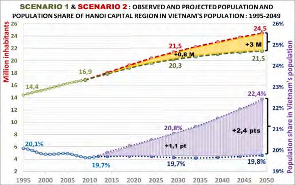
19 The HCR Plan approved in 2008 A planning region of: - 7 provinces - 13,500 km M inhabitants It set key development orientations, in particular 2 east-west mixed transportation corridors and the promotion of Hai Duong to the status of «regional» city by 2030 (source NIURP/Hansen Partnership)
.")
20 Overview of Hanoi Capital Region Today The scope of the revision includes Ha Noi capital and 9 provinces: Vinh Phuc, Bac Ninh, Hai Duong, Hung Yen, Ha Nam, Hoa Binh, Phu Tho, Thai Nguyen and Bac Giang. HCR reaches today a total area of 24,314 km2 and a population of approximately 17.5 M people (i.e. 19.1% of VN s population). A bigger region in terms of population and space, but not necessarily in terms of wealth per capita because the 3 new provinces are mainly rural (source VIUP)


21 Land use and urban network of HCR Farmland & forests: 1,702,233 Ha Residential lands: 147,775 Ha Other developed lands: 222,100 Ha Unused & vacant lands: 165,028 Ha > 454,000 Ha requested by 2020 for HCR s food security Regional urban system: 136 cities/towns Regional percentage of urban population: 30% (same as VN as whole) Average population size: 35,000 people per city/town One of the most intensely populated regions in the world, with rural densities reaching up to 1,500 people/sq.km and urban ones up to 40,000 people/sq.km (i.e a desakota ) (source VIUP)

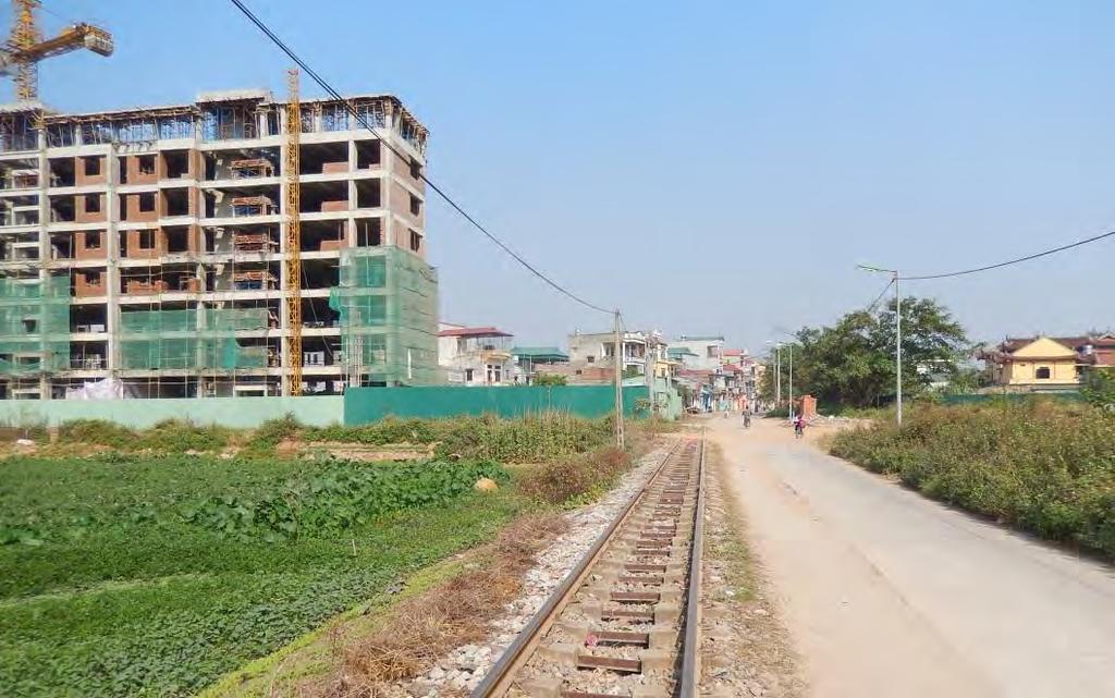


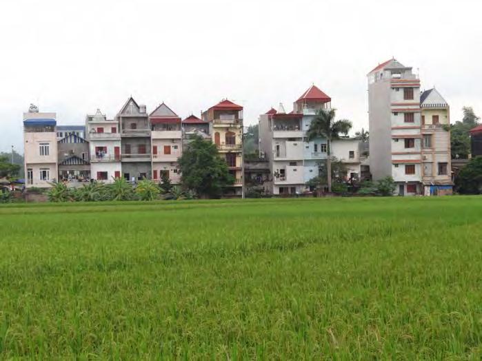
22 A desakota undergoing rapid transformations Significant and hard to manage changes, yet not as radical as in China!


23 Transportation networks of HCR A need to catch up with many big infrastructure projects, particularly in Hanoi Capital (source VIUP)


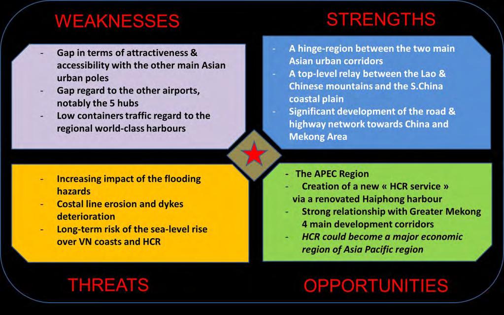

24 SWOT Analysis Quite useful to launch the debate on key development issues!

25 Benchmark of Regional «Models» Often requested yet seldom used: an exercise in style in some ways!

26 Analysis, Diagnosis & Forecasting Socioeconomic databases in Vietnam must make some progresses


27 Spatial Visions & Development Orientations HOW TO MAKE HCR INTO A LARGE POLYCENTRIC & INTEGRATED METROPOLITAN REGION? WORK IN PROGRESS!
28 Our main inputs in the project International (i.e. not only «French») expertise and knowledge in «strategic» metropolitan planning and benchmarking Capacity to adapt and tailor our «European know-how» to vietnamese planning procedures and technical skills Ability to quickly produce spatial concepts and socioeconomic growth scenarios Capacity to balance «scientific» planning approaches (statistically and GIS-driven) with more pragmatic expertises


29 Key moments in the project
30 Thank you! Xin trân trọng cảm ơn!
The World Bank. Key Dates. Project Development Objectives. Components. Public Disclosure Authorized. Implementation Status & Results Report
 Public Disclosure Authorized EAST ASIA AND PACIFIC Vietnam Transport & ICT Global Practice IBRD/IDA Specific Investment Loan FY 2008 Seq No: 16 ARCHIVED on 28-Dec-2016 ISR26429 Implementing Agencies: Hanoi
Implementation of the ESPON 2020 cooperation program. 16 January 2017 Anneloes van Noordt
 Implementation of the ESPON 2020 cooperation program 16 January 2017 Anneloes van Noordt Outline! ESPON Cooperation Program! Specific Objectives! Applied Research! Targeted Analysis! Database & Tools!
Urbanization and Sustainable Development of Cities: A Ready Engine to Promote Economic Growth and Cooperation
 Urbanization and Sustainable Development of Cities: A Ready Engine to Promote Economic Growth and Cooperation Wan Portia Hamzah Institute of Strategic and International Studies (ISIS) Malaysia 10 September
GIS Geographical Information Systems. GIS Management
 GIS Geographical Information Systems GIS Management Difficulties on establishing a GIS Funding GIS Determining Project Standards Data Gathering Map Development Recruiting GIS Professionals Educating Staff
Public Disclosure Copy. Implementation Status & Results Report Vietnam: Project for Improved Land Governance and Databases (VILG) (P154387)
 (P154387)") Public Disclosure Authorized EAST ASIA AND PACIFIC Vietnam Social, Urban, Rural and Resilience Global Practice Global Practice IBRD/IDA Investment Project Financing FY 2017 Seq No: 4 ARCHIVED on 07-Dec-2017
Public Disclosure Authorized EAST ASIA AND PACIFIC Vietnam Social, Urban, Rural and Resilience Global Practice Global Practice IBRD/IDA Investment Project Financing FY 2017 Seq No: 4 ARCHIVED on 07-Dec-2017
An online data and consulting resource of THE UNIVERSITY OF TOLEDO THE JACK FORD URBAN AFFAIRS CENTER
 An online data and consulting resource of THE JACK FORD URBAN AFFAIRS CENTER THE CENTER FOR GEOGRAPHIC INFORMATION SCIENCE AND APPLIED GEOGRAPHICS DEPARTMENT OF GEOGRAPHY AND PLANNING THE UNIVERSITY OF
Opportunities and challenges of HCMC in the process of development
 Opportunities and challenges of HCMC in the process of development Lê Văn Thành HIDS HCMC, Sept. 16-17, 2009 Contents The city starting point Achievement and difficulties Development perspective and goals
International Guidelines on Access to Basic Services for All
 International Guidelines on Access to Basic Services for All Presentation and initials lessons from implementation Accessibility to services in regions and cities : measures and policies, OECD 18 June
Regional Growth Strategy Work Session Growth Management Policy Board
 Regional Growth Strategy Work Session Growth Management Policy Board September 6, 2018 1 Overview Recap June GMPB work session Objectives and outcomes Regional geographies Growth scenarios Breakout Discussion:
Spatial information in strategic city planning - Zagreb experience. Darko Šiško City office for strategic planning, Zagreb
 Spatial information in strategic city planning - Zagreb experience Darko Šiško City office for strategic planning, Zagreb Overview Strategic city planning GI tools and trends Spatial data for strategic
Urban-Rural Partnerships in Europe
 Disclaimer: The views expressed in this document are those of the author, and do not necessarily reflect the views and policies of the Asian Development Bank (ADB), its Board of Directors, or the governments
Investigation, assessment and warning zonation for landslides in the mountainous regions of Vietnam
 Investigation, assessment and warning zonation for landslides in the mountainous regions of Vietnam (State-Funded Landslide Project SFLP) Dr. Eng. Le Quoc Hung Add: 67 Chien Thang Street, Ha Dong District,
Land Use in the context of sustainable, smart and inclusive growth
 Land Use in the context of sustainable, smart and inclusive growth François Salgé Ministry of sustainable development France facilitator EUROGI vice president AFIGéO board member 1 Introduction e-content+
ESPON 2020 Cooperation Programme. Anneloes van Noordt MC-member Belgium
 ESPON 2020 Cooperation Programme Anneloes van Noordt MC-member Belgium Anneloes.vannoordt@vlaanderen.be Outline ESPON 2020 Cooperation Programme Applied Research Targeted Analysis Database & Tools Outreach
Building the Sustainable Network of Settlements on the Caspian Sea Region of Kazakhstan
 Building the Sustainable Network of Settlements on the Caspian Sea Region of Kazakhstan Introduction The Ecological Zoning and Identification of Ecological Capacity of Natural and Socio- Economic Potential
KUNMING FORUM ON UNITED NATIONS GLOBAL GEOSPATIAL INFORMATION MANAGEMENT CITIES OF THE FUTURE: SMART, RESILIENT
 KUNMING FORUM ON UNITED NATIONS GLOBAL GEOSPATIAL INFORMATION MANAGEMENT CITIES OF THE FUTURE: SMART, RESILIENT and SUSTAINABLE Yunnan Zhenzhuang Guest House, Kunming, China 10 12 May 2017 BACKGROUND CONCEPT
SPIMA Spatial dynamics and strategic planning in metropolitan areas
 SPIMA Spatial dynamics and strategic planning in metropolitan areas Dr. Vanya Simeonova Wageningen Environmental Research Wageningen University and research, The Netherlands Key outcomes: SPIMA Framework
AND THE COOPERATION WITH SENTINEL ASIA FOR DISASTER MANAGEMENT
 Ministry of Natural resources and Environment National Remote Sensing DEpartment NATIONAL REMOTE SENSING DEPARTMENT (NRSD) AND THE COOPERATION WITH SENTINEL ASIA FOR DISASTER MANAGEMENT By: Dr. Chu Hai
Joint Planning Advisory Council July 19, 2011
 Joint Planning Advisory Council July 19, 2011 Global Cities Program Objectives Helping advance strategic thinking in a variety of critical areas. Facilitating informed decisionmaking on the part of public
The Governance of Land Use
 The planning system The Governance of Land Use United Kingdom Levels of government and their responsibilities The United Kingdom is a unitary state with three devolved governments in Northern Ireland,
SPIMA Spatial dynamics and strategic planning in metropolitan areas
 Targeted Analysis SPIMA Spatial dynamics and strategic planning in metropolitan areas Executive Summary Conference version 1 February 2018 0 1. Background To address the challenges of metropolitan development
World Bank Group GEF Program
 World Bank Group GEF Program Global Environment Facility: -Transport World Bank GEF Coordination Team Content How does GEF work? World Bank s role in the GEF partnership The GEF transport activities What
GSDI: Towards a Spatially Enabled Society
 GSDI: Towards a Spatially Enabled Society Dr. David J. Coleman, President Global Spatial Data Infrastructure Association UN Regional Cartographic Conference for the Americas, United Nations, New York,
DBSA Knowledge Week Yusuf Patel South African Planning Institute
 Sustainable Human Settlements - Institutional Issues DBSA Knowledge Week Yusuf Patel South African Planning Institute 20 October 2010 Spatial Planning for Long Term Apartheid engineered spatial economy
The Department of Urban Planning and Design offers a postgraduate course leading to the degree of Master of Science in Urban Planning.
 (THESE SYLLABUSES ARE APPLICABLE TO MASTER OF SCIENCE IN URBAN PLANNING CANDIDATES ADMITTED TO THE CURRICULUM IN THE ACADEMIC YEAR 2016-2017 AND THEREAFTER) SYLLABUSES FOR THE DEGREE OF MASTER OF SCIENCE
Public Disclosure Copy. Implementation Status & Results Report KH - Livelihood Enhancement and Association of the Poor Project (LEAP) (P153591)
 (P153591)") Public Disclosure Authorized EAST ASIA AND PACIFIC Cambodia Agriculture Global Practice IBRD/IDA Investment Project Financing FY 2017 Seq No: 1 ARCHIVED on 17-Jun-2017 ISR28362 Implementing Agencies: Ministry
Public Disclosure Authorized EAST ASIA AND PACIFIC Cambodia Agriculture Global Practice IBRD/IDA Investment Project Financing FY 2017 Seq No: 1 ARCHIVED on 17-Jun-2017 ISR28362 Implementing Agencies: Ministry
Date: March 31, 2014 PATE; fyril 2.3,2 >H
 aj BRAMPTON fifs Rower City XH-l-f r.t "»* City Council The Corporation of the City of Brampton SRAMPTON CITY COUNCIL Date: March 31, 2014 PATE; fyril 2.3,2 >H File: POO GR VisWhtoJed ^t'th-meeh'^a Subject:
Presentation by Thangavel Palanivel Senior Strategic Advisor and Chief Economist UNDP Regional Bureau for Asia-Pacific
 Presentation by Thangavel Palanivel Senior Strategic Advisor and Chief Economist UNDP Regional Bureau for Asia-Pacific The High-Level Euro-Asia Regional Meeting on Improving Cooperation on Transit, Trade
NCAVES - Global initiative and national pilots
 NCAVES - Global initiative and national pilots Kavita Sharma UN Environment Pretoria, March 2018 Outline 1. Global initiative > Introduction > Objectives and deliverables >Activities in 2017 and 2018 2.
Economic and Social Council
 United Nations Economic and Social Council Distr.: General 18 July 2016 Original: English Committee of Experts on Global Geospatial Information Management Sixth session New York, 3-5 August 2016 Item 2
Article: National Geographic Department
 Article: National Geographic Department A glimpse of the organization and its activities in brief June 2016 By: Mr. Khachonesack DOUANGPHOUTHA 1. Introduction Lao People s Democratic Republic or Laos is
UN-GGIM: Strengthening Geospatial Capability
 Fifth Plenary Meeting of UN-GGIM: Europe Brussels, 6-7 June 2018 UN-GGIM: Strengthening Geospatial Capability Walking the talk to leave no one behind Greg Scott, UN-GGIM Secretariat Environmental Statistics
Spatially Enabled Society
 International Seminar on Land Administration Trends and Issues in Asia and the Pacific Region Spatially Enabled Society Abbas Rajabifard Vice Chair PCGIAP-WG3 Vice-President (President Elect), GSDI Association
The international patterns of spatial planning system and choice of China. Cai yumei China land use planning and surveying institute (China, beijing)
") FIG Working Week, Rome, Italy 6 10 May 2012 The international patterns of spatial system and choice of China Cai yumei China land use and surveying institute (China, beijing) Outline Background Problem
FIG Working Week, Rome, Italy 6 10 May 2012 The international patterns of spatial system and choice of China Cai yumei China land use and surveying institute (China, beijing) Outline Background Problem
Legal problems of environmental management. Spatial planning and space management. M. Gajewski 2014 / 2015
 Legal problems of environmental management Spatial planning and space management M. Gajewski 2014 / 2015 Course contents (in brief) Constitutional basis of the environment protection system. General principles
The Governance of Land Use
 The Governance of Land Use Country fact sheet Austria The planning system Levels of government and their responsibilities Austria is a federal state with three levels of government; the national level,
D2. Addressing tourism related mobility
 14-15 MAY 2018 NICOSIA, CYPRUS D2. Addressing tourism related mobility FROM SUMP TO SRTMP ALONG DANUBE Prof. Lucia Ilieva CSDCS, Bulgaria Agnes Kurzweil Environmental Agency, Austria, Andreas Friedwagner
The Council Study: Social assessment approach and methodology
 Preliminary draft for internal discussion The Council Study: Social assessment approach and methodology Vientiane, September 24 2015 Social /economic assessment team Basin Development Plan (BDP) Programme
UNESCO World Heritage Centre - Arab States Unit
 UNESCO World Heritage Centre - Arab States Unit Post-Conflict Reconstruction in the Middle East Context and in the Old City of Aleppo in Particular UNESCO Headquarter, 18-19 June 2015 ACTION PLAN resulting
Land Use Planning and Agriculture: Austrian Experiences and Challenges I
 Land Use Planning and Agriculture: Austrian Experiences and Challenges I SULANET Summer School 2016 Walter Seher BOKU Vienna 1 Land Use Planning and Agriculture 2 Land Use Planning and Agriculture Agriculture
THE ROLE OF REGIONAL SPATIAL PLANNING IN SUPPORTING LONG-TERM ECONOMIC GROWTH IN NORTHERN IRELAND
 THE ROLE OF REGIONAL SPATIAL PLANNING IN SUPPORTING LONG-TERM ECONOMIC GROWTH IN NORTHERN IRELAND Jenny Pyper Director 6 th Annual ICLRD Conference 20 January 2011 PURPOSE OF REGIONAL PLANNING Framework
Identifying Megaregions in the US: Implications for Infrastructure Investment
 7. 10. 2 0 08 Identifying Megaregions in the US: Implications for Infrastructure Investment Dr. Myungje Woo Dr. Catherine L. Ross Jason Barringer Harry West Jessica Lynn Harbour Doyle Center for Quality
Proposed Scope of Work Village of Farmingdale Downtown Farmingdale BOA Step 2 BOA Nomination Study / Draft Generic Environmental Impact Statement
 Proposed Scope of Work Village of Farmingdale Downtown Farmingdale BOA Step 2 BOA Nomination Study / Draft Generic Environmental Impact Statement The scope of work that follows incorporates and covers
Vietnam Coastal Erosion - Cause and Challenges -
 Administration of Sea and Islands Center for Oceanography University of Transport and Communications, Hanoi Vietnam Vietnam Coastal Erosion - Cause and Challenges - Presenters: Pham Hoang KIEN Le Van CONG
Advanced Readings. Environment and Land Use Concentration The following seminars and studios would apply
 Community Development and Housing Concentration URP 720 Urban Housing Policies URP 722 Community Development and Housing URP 724 Urban Revitalization Studio URP 726 Citizen Participation Strategies URP
The National Spatial Strategy
 Purpose of this Consultation Paper This paper seeks the views of a wide range of bodies, interests and members of the public on the issues which the National Spatial Strategy should address. These views
THE ROLE OF GEOSPATIAL AT THE WORLD BANK
 THE ROLE OF GEOSPATIAL AT THE WORLD BANK INSPIRE Conference Barcelona, Spain September 26, 2016 Kathrine Kelm Senior Land Administration Specialist Global Land and Geospatial Unit The World Bank Group
Current Status of Vietnam Coastal Erosion and Major Measures for Mitigation
 Vietnam Administration of Sea and Islands Center for Oceanography University of Transport and Communications Current Status of Vietnam Coastal Erosion and Major Measures for Mitigation Case Study: Thanh
The Governance of Land Use
 The Governance of Land Use COUNTRY FACT SHEET SPAIN The planning system Levels of government and their responsibilities Spain is defined by the OECD as a quasi-federal state with 4 levels of government;
DETERMINE OF REGIONAL DEVELOPMENT STRATEGIES IN IZMIR
 Sukran Yalpir Asli Bozdag Saban Inam DETERMINE OF REGIONAL DEVELOPMENT STRATEGIES IN IZMIR Globalization INTRODUCTION Economic pressure cause Economic migration cause cause Spatial organizations Spatial
Third Cohesion report February 2004
 February 2004 A new partnership for cohesion Convergence, Competitiveness and Co-operation METREX meeting S. Sebastian, Luisa Sanches DG REGIO The 3rd CR structure 1. Analysis of situation and trends in
Esri and GIS Education
 Esri and GIS Education Organizations Esri Users 1,200 National Government Agencies 11,500 States & Regional Agencies 30,800 Cities & Local Governments 32,000 Businesses 8,500 Utilities 12,600 NGOs 11,000
Institute of Statistical and Geographical Information of Jalisco State Geospatial Technologies, platforms and services at a subnational level
 Institute of Statistical and Geographical Information of Jalisco State Geospatial Technologies, platforms and services at a subnational level México, November 2017 Unique organization in its type SDG 17.18:
Section 2. Indiana Geographic Information Council: Strategic Plan
 Section 2. Indiana Geographic Information Council: Strategic Plan Introduction A geographic information system (GIS) is an automated tool that allows the collection, modification, storage, analysis, and
Why care about metropolitan and regional perspectives?
 Metropolitan challenges and solutions Why care about metropolitan and regional perspectives? Irma Karjalainen, Director, Helsinki Region Environmental Services Authority HSY, LUMAT Conference, 25 September
The Efforts of Building GIS Infrastructure in a Newly Independent State: The case of Timor Leste *
 UNITED NATIONS E/CONF.100/IP.12 ECONOMIC AND SOCIAL COUNCIL Eighteenth United Nations Regional Cartographic Conference for Asia and the Pacific Bangkok, 26-29 October 2009 Item 7(b) of the provisional
Together towards a Sustainable Urban Agenda
 Together towards a Sustainable Urban Agenda The City We (Youth) Want Preliminary findings from youth consultations Areas Issue Papers Policy Units 1.Social Cohesion and Equity - Livable Cities 2.Urban
ESPON evidence on European cities and metropolitan areas
 BEST METROPOLISES Final Conference 18 April 2013, Warsaw ESPON evidence on European cities and metropolitan areas Michaela Gensheimer Structure of Intervention Content Part I: What is the ESPON 2013 Programme?
Introduction and Project Overview
 Greater New Orleans Regional Land Use Modeling GIS Techniques in a P olitical C ontext Louisiana Remote Sensing and GIS Workshop Wednesday, April 24, 2013 Working Towards a Shared Regional Vision Introduction
Vincent Goodstadt. Head of European Affairs METREX European Network
 Vincent Goodstadt Head of European Affairs METREX European Network METREX (Network of 50 European Metropolitan Regions and Areas ) Exchanging Knowledge (e.g. Benchmarking) Climate Change CO2/80/50 Expertise
Subject: Note on spatial issues in Urban South Africa From: Alain Bertaud Date: Oct 7, A. Spatial issues
 Page 1 of 6 Subject: Note on spatial issues in Urban South Africa From: Alain Bertaud Date: Oct 7, 2009 A. Spatial issues 1. Spatial issues and the South African economy Spatial concentration of economic
THE MODEL OF SPATIAL ORGANIZATION OF COASTAL FISHERMEN VILLAGES IN THE SOUTH CENTRAL COAST OF VIETNAM
 i MINISTRY OF EDUCATION AND TRAINING MINISTRY OF CONSTRUCTION HANOI ARCHITECTURAL UNIVERSITY TRAN VAN HIEN THE MODEL OF SPATIAL ORGANIZATION OF COASTAL FISHERMEN VILLAGES IN THE SOUTH CENTRAL COAST OF
Sustainable Development Goal 11 and the New Urban Agenda: can planning deliver? Vanessa Watson University of Cape Town 2016
 Sustainable Development Goal 11 and the New Urban Agenda: can planning deliver? Vanessa Watson University of Cape Town 2016 .to reinvigorate the global political commitment to the sustainable development
The Department of Urban Planning and Design offers a postgraduate course leading to the degree of Master of Science in Urban Planning.
 (THESE SYLLABUSES ARE APPLICABLE TO MASTER OF SCIENCE IN URBAN PLANNING CANDIDATES ADMITTED TO THE CURRICULUM IN THE ACADEMIC YEAR 2017-2018 AND THEREAFTER) SYLLABUSES FOR THE DEGREE OF MASTER OF SCIENCE
Assessment of Sustainable Land Use within the Town Planning Process Experiences with a Multi Criteria Approach (MCA)
") Assessment of Sustainable Land Use within the Town Planning Process Experiences with a Multi Criteria Approach (MCA) Dipl.-Geogr. Sophie Schetke Dipl.-Ing. Benedikt Frielinghaus, University of Bonn, Germany
Assessment of Sustainable Land Use within the Town Planning Process Experiences with a Multi Criteria Approach (MCA) Dipl.-Geogr. Sophie Schetke Dipl.-Ing. Benedikt Frielinghaus, University of Bonn, Germany
PRIMA. Planning for Retailing in Metropolitan Areas
 PRIMA Planning for Retailing in Metropolitan Areas Metropolitan Dimension to sustainable retailing futures Metropolitan strategies Retailing in city and town centres will be a primary component of any
Experience and perspectives of using EU funds and other funding for the implementation of district renovation projects
 Experience and perspectives of using EU funds and other funding for the implementation of district renovation projects Ministry of the Interior of Lithuania Regional policy department Administration, coordination,
The Governance of Land Use
 The planning system Levels of government and their responsibilities The Governance of Land Use COUNTRY FACT SHEET NORWAY Norway is a unitary state with three levels of government; the national level, 19
Tackling urban sprawl: towards a compact model of cities? David Ludlow University of the West of England (UWE) 19 June 2014
 19 June 2014") Tackling urban sprawl: towards a compact model of cities? David Ludlow University of the West of England (UWE) 19 June 2014 Impacts on Natural & Protected Areas why sprawl matters? Sprawl creates environmental,
Tackling urban sprawl: towards a compact model of cities? David Ludlow University of the West of England (UWE) 19 June 2014 Impacts on Natural & Protected Areas why sprawl matters? Sprawl creates environmental,
Voices from Private Sector: Insights for Future NSDI Development in Indonesia
 Voices from Private Sector: Insights for Future NSDI Development in Indonesia Ta n d a n g Yu l i a d i D w i P u t ra, Ryosuke S h i b a s a k i I n st i t u t e o f I n d u st r i a l S c i e n c e,
The Governance of Land Use
 The planning system Levels of government and their responsibilities The Governance of Land Use Country fact sheet Germany Germany is a federal country with four levels of government. Below the national
Urbis Hanoi 2010, GIS Instrument for Comprehensive Management of Urban Development Information
 Urbis Hanoi 2010, GIS Instrument for Comprehensive Management of Urban Development Information Ir Michel VAN ACKER, Belgium Key word: GIS, Hanoi, cadastre, patrimony, town planning SUMMARY The rapid growth
ESPON support for Targeted Analyses Ilona Raugze Director
 ESPON support for Targeted Analyses Ilona Raugze Director ESPON EGTC 14 November 2017 ESPON EGTC workshop Targeted Analysis in support of better policy making in cities and regions Inspire policy making
STRATEGY FOR SPATIAL PLANNING AND RENEWAL OF URBAN POLICY: THE SOFA OF CENTRAL METROPOLITAN AREA
 KINGDOM OF MOROCCO MINISTRY OF SPATIAL DEVELOPMENT, WATER AND ENVIRONMENT STRATEGY FOR SPATIAL PLANNING AND RENEWAL OF URBAN POLICY: THE SOFA OF CENTRAL METROPOLITAN AREA STATE AND ORIENTATION OF THE SNAT
2018/1 The integration of statistical and geospatial information. The Regional Committee of UN-GGIM: Americas:
 The following are the conclusions and recommendations of the Regional Committee of the United Nations on Global Geospatial Information Management for the Americas, during its Fifth Session, Thursday 8
Excel Geomatics: Offering Excellence with Unique Consultancy & Services
 Excel Geomatics: Offering Excellence with Unique Consultancy & Services Providing consultancy and value Added Services using Remote Sensing, Photogrammetry and LiDAR in areas such as Agriculture, Forestry,
Conference on Urban Development Strategies in the Mediterranean Barcelona, March 14-15, 2011
 Analysing Urban Development Strategies: the OECD Approach by Adam Knelman Ostry Counsellor, Regional Development Policy adam.ostry@oecd.org Conference on Urban Development Strategies in the Mediterranean
2007 / 2008 GeoNOVA Secretariat Annual Report
 2007 / 2008 GeoNOVA Secretariat Annual Report Prepared for: Assistant Deputy Minister and Deputy Minister of Service Nova Scotia and Municipal Relations BACKGROUND This report reflects GeoNOVA s ongoing
2 nd Semester. Core Courses. C 2.1 City and Metropolitan Planning. Module 1: Urban Structure and Growth Implications
 2 nd Semester Core Courses C 2.1 City and Metropolitan Planning Module 1: Urban Structure and Growth Implications Growth of cities; cities as engine of growth; urban sprawl; land value, economic attributes
SDI Developments in the World s Currently Existing Mega Cities
 SDI Developments in the World s Currently Existing Mega Cities Silke Boos and Hartmut Müller FIG Working Week 2009 Surveyors Key Role in Accelerated Development, Eilat, Israel, 3-8 May 2009 TS 1B SDI in
Frequently Asked Questions
 What is the Regional Transit Engagement Series? As one of the fastest growing regions in the country, there is recognition that long-term transit planning efforts should be accelerated if we are to remain
geographic patterns and processes are captured and represented using computer technologies
 Proposed Certificate in Geographic Information Science Department of Geographical and Sustainability Sciences Submitted: November 9, 2016 Geographic information systems (GIS) capture the complex spatial
National SDG Data Hubs: Statistical integration and geographic disaggregation (Philippines)
") National SDG Data Hubs: Statistical integration and geographic disaggregation (Philippines) 5 th High Level Forum on United Nations Global Geospatial Information Management Implementing the Sustainable
National SDG Data Hubs: Statistical integration and geographic disaggregation (Philippines) 5 th High Level Forum on United Nations Global Geospatial Information Management Implementing the Sustainable
A Method for Mapping Settlement Area Boundaries in the Greater Golden Horseshoe
 A Method for Mapping Settlement Area Boundaries in the Greater Golden Horseshoe Purpose This paper describes a method for mapping and measuring the lands designated for growth and urban expansion in the
Study on Shandong Expressway Network Planning Based on Highway Transportation System
 Study on Shandong Expressway Network Planning Based on Highway Transportation System Fei Peng a, Yimeng Wang b and Chengjun Shi c School of Automobile, Changan University, Xian 71000, China; apengfei0799@163.com,
CREATIVITY, CULTURE & TERRITORIAL ATTRACTIVENESS IN URBAN RENEWAL AREA : THE CASE OF VAULX-EN-VELIN
 CREATIVITY, CULTURE & TERRITORIAL ATTRACTIVENESS IN URBAN RENEWAL AREA : THE CASE OF VAULX-EN-VELIN Stéphane BIENVENUE: Mayor s advisor. City of Vaulx-en-Velin 1. Situation GreaterLyon and its57 cities
SOUTH DAKOTA BOARD OF REGENTS. Academic and Student Affairs ******************************************************************************
 SOUTH DAKOTA BOARD OF REGENTS Academic and Student Affairs AGENDA ITEM: 7 C (4) DATE: June 28-30, 2016 ****************************************************************************** SUBJECT: New Minor:
5 Principles. RehabiMed Method for the rehabilitation of Traditional Mediterranean Architecture ORIENTATION DIAGNOSIS STRATEGY ACTION FOLLOW-UP
 Principles Integration (versus isolation) Globalism (versus specialization) Coordination (sharing versus selfishness) Flexibility (versus rigidity) Adaptability ( versus univocal attitude) RehabiMed Method
EUROPEAN INVESTMENT BANK
 EUROPEAN INVESTMENT BANK RISC Consortium and the UNU-CRIS Summer School/ Students Research Symposium, 3 rd July 2012, Luxembourg Regional Projects good practice? Kamil Dörfler 1 Outline General background
The World Bank Ho Chi Minh City Green Transport Development (P126507)
") Public Disclosure Authorized EAST ASIA AND PACIFIC Vietnam Transport & ICT Global Practice IBRD/IDA Investment Project Financing FY 2015 Seq No: 6 ARCHIVED on 25-Dec-2017 ISR31002 Implementing Agencies:
Public Disclosure Authorized EAST ASIA AND PACIFIC Vietnam Transport & ICT Global Practice IBRD/IDA Investment Project Financing FY 2015 Seq No: 6 ARCHIVED on 25-Dec-2017 ISR31002 Implementing Agencies:
Experiences of public-private partnerships in the Euromediterranean relations and in the Po Valley, promoting a more balanced European territory
 Experiences of public-private partnerships in the Euromediterranean relations and in the Po Valley, promoting a more balanced European territory Claudio Tolomelli PolyMetrexPlus project s objectives To
COURSES OUTSIDE THE JOURNALISM SCHOOL
 COURSES OUTSIDE THE JOURNALISM SCHOOL Students are not limited to the science courses on this list and may select classes from additional specialties. In accordance with University policy, 400-level courses
Low Density Areas : Places of Opportunity. Enrique Garcilazo, OECD Directorate for Public Governance and Territorial Development
 Low Density Areas : Places of Opportunity Enrique Garcilazo, OECD Directorate for Public Governance and Territorial Development Open Days, Brussels, 11 th October, 2016 Outline 1. Performance low density
MALDIVES. Regional Expert Workshop On Land Accounting For SDG Monitoring & Reporting (25-27 th Sept 2017) - Fathimath Shanna, Aishath Aniya -
 - Fathimath Shanna, Aishath Aniya -") MALDIVES Regional Expert Workshop On Land Accounting For SDG Monitoring & Reporting (25-27 th Sept 2017) - Fathimath Shanna, Aishath Aniya - ABOUT MALDIVES Approximately 860 km long and 120 km wide Consists
MALDIVES Regional Expert Workshop On Land Accounting For SDG Monitoring & Reporting (25-27 th Sept 2017) - Fathimath Shanna, Aishath Aniya - ABOUT MALDIVES Approximately 860 km long and 120 km wide Consists
Dr.Sinisa Vukicevic Dr. Robert Summers
 Dr.Sinisa Vukicevic Dr. Robert Summers "Planning" means the scientific, aesthetic, and orderly disposition of land, resources, facilities and services with a view to securing the physical, economic and
Date: June 19, 2013 Meeting Date: July 5, Consideration of the City of Vancouver s Regional Context Statement
 Section E 1.5 To: From: Regional Planning and Agriculture Committee Lee-Ann Garnett, Senior Regional Planner Planning, Policy and Environment Department Date: June 19, 2013 Meeting Date: July 5, 2013 Subject:
Making maps: Traditions and perceptions in Europe. European spatial planning and cartographic representations
 ESPON Create Europe! Making maps: Traditions and perceptions in Europe Dr. Stefanie Dühr University of the West of England, Bristol, UK European spatial planning and cartographic representations Scenarios.
REGIONAL SDI DEVELOPMENT
 REGIONAL SDI DEVELOPMENT Abbas Rajabifard 1 and Ian P. Williamson 2 1 Deputy Director and Senior Research Fellow Email: abbas.r@unimelb.edu.au 2 Director, Professor of Surveying and Land Information, Email:
Geospatial Information and Services for Disasters (GIS4D)
") Geospatial Information and Services for Disasters (GIS4D) 31 July 2017 Tae Hyung KIM ICT and Disaster Risk Reduction Division (IDD) UNESCAP 1 About ESCAP Who is ESCAP? United Nations Economic and Social
Geospatial Information and Services for Disasters (GIS4D) 31 July 2017 Tae Hyung KIM ICT and Disaster Risk Reduction Division (IDD) UNESCAP 1 About ESCAP Who is ESCAP? United Nations Economic and Social
Strengthening the cooperation in the region: Carpathian, Tisa,, Danube and Black Sea areas
 Strengthening the cooperation in the region: Carpathian, Tisa,, Danube and Black Sea areas 14th October 2009 SEE Annual Conference Advancing development through transnational cooperation in South East