Objective To enhance the management of defended coastlines through integration of coastal erosion and flood risk models
|
|
|
- Derick Page
- 5 years ago
- Views:
Transcription
1 School of Oriental and African Studies, 4 th October 2011 Practitioner workshop on asset management Shoreline evolution for flood risk assessment Dr Stuart Stripling EPSRC Grant: EP/FP202511/1 FRMRC2 WP4.3 Broad Scale Integration of Coastal Flood and Erosion Risk Models Research carried out by HR Wallingford Ltd. Industrial support from Halcrow Objective To enhance the management of defended coastlines through integration of coastal erosion and flood risk models
2 FRMRC2 WP4.3 Broad Scale Integration of Coastal Flood and Erosion Risk Models Research carried out by HR Wallingford Ltd. Industrial support from Halcrow Objective To enhance the management of defended coastlines through integration of coastal erosion and flood risk models Today s Contents Scope of research Probabilistic modelling (Erosion Risk Model) Application of ERM Integration of erosion and flood risk models Model operability Application of integrated model at Pilot site
3 Scope (1 st Phase) Rapid broad scale shoreline evolution modelling Numerical scheme reliable, fast and accurate Probabilistic shoreline evolution modelling Stochastic nature allows event based input e.g. Rivers, Cliffs Provides stochastic output Mean, maximum, minimum positions Histograms (cliff top position, toe level at seawall) Scope (1 st Phase) Rapid broad scale shoreline evolution modelling Numerical scheme reliable, fast and accurate Probabilistic (erosion risk) model Stochastic nature allows event based input e.g. Rivers, Cliffs Provides stochastic output Mean, maximum, minimum positions Histograms (cliff top position, toe level at seawall)
4 Scope (1 st Phase) Rapid broad scale shoreline evolution modelling Numerical scheme reliable, fast and accurate Probabilistic (erosion risk) model Stochastic nature allows event based input e.g. Rivers, Cliffs Provides stochastic output Mean, maximum, minimum positions Histograms (cliff top position, toe level at seawall) Scope (1 st Phase) Rapid broad scale shoreline evolution modelling Numerical scheme reliable, fast and accurate Probabilistic (erosion risk) modelling Stochastic nature allows event based input e.g. Rivers, Cliffs Provides stochastic output Mean, maximum, minimum positions Histograms (cliff top position, toe level at seawall)
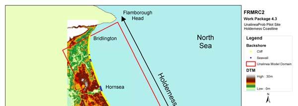
5 Scope (2 nd Phase) Moulding of existing RASP SU flood risk model FRA presently considers beach to be static defence Modified to accept histogram i.e. dynamic defence Integrated model of erosion and flood risk Pilot site proof of concept application Holderness coastline, Hornsea in particular Scope (2 nd Phase) Moulding of existing RASP SU flood risk model FRA presently considers beach to be static defence Modified to accept histogram i.e. dynamic defence Integrated model of erosion and flood risk Pilot site proof of concept application Holderness coastline, Hornsea in particular
")
6 Scope (2 nd Phase) Moulding of existing RASP SU flood risk model FRA presently considers beach to be static defence Modified to accept histogram i.e. dynamic defence Integrated model of erosion and flood risk Pilot site proof of concept application Holderness coastline, Hornsea in particular Scope (2 nd Phase) Moulding of existing RASP SU flood risk model Flood risk model considers beach to be static defence Modified to accept histogram i.e. dynamic defence Integrated model of erosion and flood risk Pilot site proof of concept application Holderness coastline, Hornsea in particular
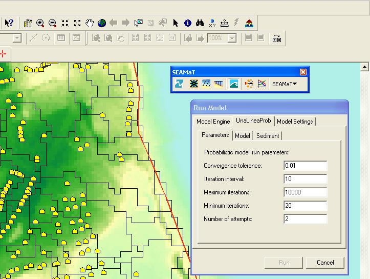
7 s18 Probabilistic Modelling Stable, rapid and accurate deterministic model Becomes an erosion risk model when likelihood of beach behaviour is established: 1. Derive morphological events from wave time series 2. Sample X years of morphological events at random 3. Simulate shoreline evolution with deterministic model 4. Repeat 2. and 3. above from same shoreline start position until variance of the mean of the final shoreline position converges Stochastic modelling allows event based sources s23 Probabilistic Modelling Stable, rapid and accurate deterministic model Becomes an erosion risk model when likelihood of beach behaviour is established: 1. Derive morphological events from wave time series 2. Sample X years of morphological events at random 3. Simulate shoreline evolution with deterministic model 4. Repeat 2. and 3. above from same shoreline start position until variance of the mean of the final shoreline position converges Stochastic modelling allows event based sources
8 Slide 13 s18 Or you could use the slides that were presented earlier this week for this bit. They are appended at the end of this.ppt for convenience. ss, 09/07/2010 Slide 14 s23 Or you could use the slides that were presented earlier this week for this bit. They are appended at the end of this.ppt for convenience. ss, 09/07/2010
9 s30 Probabilistic Modelling Stable, rapid and accurate deterministic model Becomes an erosion risk model when likelihood of beach behaviour is established: 1. Derive morphological events from wave time series 2. Sample X years of morphological events at random 3. Simulate shoreline evolution with deterministic model 4. Repeat 2. and 3. above from same shoreline start position until variance of the mean of the final shoreline position converges Stochastic modelling allows event based sources s24 Probabilistic Modelling Stable, rapid and accurate deterministic model Becomes an erosion risk model when likelihood of beach behaviour is established: 1. Derive morphological events from wave time series 2. Sample X years of morphological events at random 3. Simulate shoreline evolution with deterministic model 4. Repeat 2. and 3. above from same shoreline start position until variance of the mean of the final shoreline position converges Stochastic modelling allows event based sources
10 Slide 15 s30 Or you could use the slides that were presented earlier this week for this bit. They are appended at the end of this.ppt for convenience. ss, 09/07/2010 Slide 16 s24 Or you could use the slides that were presented earlier this week for this bit. They are appended at the end of this.ppt for convenience. ss, 09/07/2010
11 s25 Probabilistic Modelling Stable, rapid and accurate deterministic model Becomes an erosion risk model when likelihood of beach behaviour is established: 1. Derive morphological events from wave time series 2. Sample X years of morphological events at random 3. Simulate shoreline evolution with deterministic model 4. Repeat 2. and 3. above from same shoreline start position until variance of the mean of the final shoreline position converges Stochastic modelling allows event based sources s26 Probabilistic Modelling Stable, rapid and accurate deterministic model Becomes an erosion risk model when likelihood of beach behaviour is established: 1. Derive morphological events from wave time series 2. Sample X years of morphological events at random 3. Simulate shoreline evolution with deterministic model 4. Repeat 2. and 3. above from same shoreline start position until variance of the mean of the final shoreline position converges Stochastic modelling allows event based sources
12 Slide 17 s25 Or you could use the slides that were presented earlier this week for this bit. They are appended at the end of this.ppt for convenience. ss, 09/07/2010 Slide 18 s26 Or you could use the slides that were presented earlier this week for this bit. They are appended at the end of this.ppt for convenience. ss, 09/07/2010
13 s22 Probabilistic Modelling Stable, rapid and accurate deterministic model Becomes an erosion risk model when likelihood of beach behaviour is established: Derive morphological events from wave time series Sample year of morphological events at random Simulate shoreline evolution with deterministic model Repeat above from same shoreline start position until variance of the mean of the final shoreline position converges Stochastic modelling allows event based sources Event based Sources River loading Nourishment Simple soft cliff recession model Based on observed cliff behaviour Pre fall slope (assigned confidence limits) Post fall stable slope (assigned confidence limits) Toe position provided by shoreline model System state test (ie fail or no fail) each time step
14 Slide 19 s22 Or you could use the slides that were presented earlier this week for this bit. They are appended at the end of this.ppt for convenience. ss, 09/07/2010
 Toe position provided by shoreline model System state test (ie fail or no fail) each time step s28 Application: Fiume Savuto, Italy River loads From river model Load v RP River")
15 Event based Sources River loading Nourishment Simple soft cliff recession model Based on observed cliff behaviour Pre fall slope (assigned confidence limits) Post fall stable slope (assigned confidence limits) Toe position provided by shoreline model System state test (ie fail or no fail) each time step s28 Application: Fiume Savuto, Italy River loads From river model Load v RP River engineering Random sampling
16 Slide 22 s28 Or you could use the slides that were presented earlier this week for this bit. They are appended at the end of this.ppt for convenience. ss, 09/07/2010
17 s29 Application: Fiume Savuto, Italy Nourishment South of river User defined Event based Sources River loading Nourishment Simple soft cliff recession module Based on observed cliff behaviour Pre fall slope (assigned confidence limits) Post fall stable slope (assigned confidence limits)
18 Slide 23 s29 Or you could use the slides that were presented earlier this week for this bit. They are appended at the end of this.ppt for convenience. ss, 09/07/2010


19 Event based Sources River loading Nourishment Simple soft cliff recession module Based on observed cliff behaviour Pre fall slope (assigned confidence limits) Post fall stable slope (assigned confidence limits) Simple Cliff recession Model As beach width reduces, cliff toe recedes Pre fall slope required

 Data management by GIS")
20 Simple Cliff recession Model Cliff fails Post fall stable slope required Probabilistic Model Summary Provides measure of long term Erosion Risk Histogram of cliff top position Histogram of shoreline position Histogram of toe levels at seawalls Allows incorporation of event based sources Rapid (~seconds/minutes) Data management by GIS data model
21 Probabilistic Model Summary Provides measure of long term Erosion Risk Histogram of cliff top position Histogram of shoreline position Histogram of toe levels at seawalls Allows incorporation of event based sources Rapid (~seconds/minutes) Data management by GIS data model Probabilistic Model Summary Provides measure of long term Erosion Risk Histogram of cliff top position Histogram of shoreline position Histogram of toe levels at seawalls Allows incorporation of event based sources Rapid (~seconds/minutes) Data management by GIS data model
22 Probabilistic Model Summary Provides measure of long term Erosion Risk Histogram of cliff top position Histogram of shoreline position Histogram of toe levels at seawalls Allows incorporation of event based sources Rapid (~seconds/minutes) Data management by GIS data model Probabilistic Model Summary Provides measure of long term Erosion Risk Histogram of cliff top position Histogram of shoreline position Histogram of toe levels at seawalls Allows incorporation of event based sources Rapid (~seconds/minutes) Data management by GIS data model PRINCIPLES CONFORM WITH THE METHODS USED TO ESTABLISH FLOOD RISK UNDER EA s NaFRA
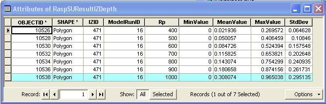
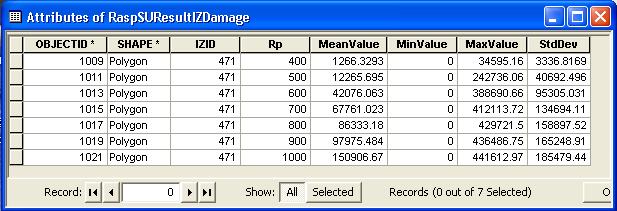
23 NaFRA: RASP SU Risk Assessment for Strategic Planning RASP SU models provide a Monte Carlo coastal flood risk simulation framework for exploration of uncertainty in various modelling parameters and input variables RASP SU results include histograms of overtopping volume, probability of inundation, expected annual damage (EAD) and flood depths NaFRA: RASP SU Risk Assessment for Strategic Planning RASP SU models provides Monte Carlo coastal flood risk simulation framework for exploration of uncertainty in various modelling parameters and input variables RASP SU results include statistics of overtopping volume, probability of inundation, expected annual damage (EAD) and flood depths
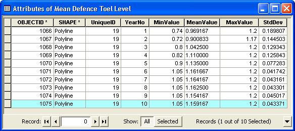
24 Integrated Modelling for each defence length. HISTOGRAM OF TOE LEVELS CREST LEVEL OT RATE FOR RP NO FAIL SYSTEM STATE SAMPLED FROM DEFENCE FRAGILITY FAIL RFSM/ EAD Integrated Modelling Requires thorough data management model Ease of operation..

25 Integrated Modelling Requires thorough data management model Ease of operation.. Model Operability
26 Model Operability Model Operability
27 Model Operability Model Operability
28 Model Operability Pilot Site: Location


29 Pilot Site: Seawall and Cliff.. Pilot Site: Groynes.


30 Pilot Site: Erosion Risk Model Pilot Site: Erosion Risk Model HISTOGRAM OF TOE LEVELS


31 Pilot Site: Cliff recession Module Pilot Site: RFSM Impact Zones


32 Pilot Site: Selected Impact Zone Pilot Site: Property and Defences
33 Pilot Site: Toe levels for defences Pilot Site: Toe levels for defences
34 Pilot Site: Flood depths Pilot Site: Flood depths
35 Pilot Site: Expected damage ( ) Pilot Site: Expected damage ( )
36 Scenario Testing Return to deterministic shoreline evolution model and, e.g; Remove groynes Add groynes Nourish Increase sea level Not presented here, but the underlined models would then return new statistics for flood depth, EAD etc. and allow scheme appraisal/ optimisation Summary Fast, reliable and accurate broad scale 1 line model Consider the beach as a system of elements Defence types, backshore types Monte Carlo running of ERM to give beach statistics Underlining of ERM and RFSM Allows improved scenario testing that takes into account the dynamic behaviour of beaches
37 Where next? Consideration of additional structures in ERM Improve seawalls/ groynes/ beach levels Include breakwaters Include further backshore modules in ERM Dunes/ barrier beaches Auto calibration of ERM Climate impacts Nearshore seabed updating Software optimisation for ease of scenario modelling Acknowledgements FLOODsite FRMRC Autorita di Bacino Regione Calabria, Italy HR Wallingford Uni. Oxford (Knowledge Transfer Secondment) Regione Veneto, Italy

38 s31 Simple scenario Model Development s32 Model Development Investigation of numerical scheme performance for broad scale application of 1 line model
39 Slide 63 s31 Illustration of stability issues (at a groyne) for long time and large spatial discretisation for a variety of numerical solution methods. Explicit: Euler, Adams-Bashforth, Runge-Kutta Implicit: Crank-Nicholson 3-level Graph also includes analytical solution ss, 09/07/2010 Slide 64 s32 Illustration of stability issues (at a groyne) for long time and large spatial discretisation for a variety of numerical solution methods. Explicit: Euler, Adams-Bashforth, Runge-Kutta Implicit: Crank-Nicholson 3-level Graph also includes analytical solution ss, 09/07/2010
 Groyne")

40 s33 Model Development Optimisation of time and space discretisation Comparison of stability (Euler) Groyne Point source Model Development Seasonal variation in beach slope alters yswash Typical seasonal beach slopes required
41 Slide 65 s33 Interesting schematisation of stability issues for numerical solver (only one of those we have tested/ are testing) given varying time and space discretisation. ss, 09/07/2010

42 s27 Application: Fiume Savuto, Italy Location
43 Slide 67 s27 Or you could use the slides that were presented earlier this week for this bit. They are appended at the end of this.ppt for convenience. ss, 09/07/2010
A GIS framework for probabilistic modelling of coastal erosion and flood risk
 A GIS framework for probabilistic modelling of coastal erosion and flood risk M Panzeri 1, S Stripling 2 and T Chesher 3 1 Principal Scientist, Flood Management Group, HR Wallingford Ltd, Howbery Park,
Numerical models in context of coastal climate change, adaptation and protection schemes. Nils Drønen Head of Innovation, CED, DHI
 Numerical models in context of coastal climate change, adaptation and protection schemes Nils Drønen Head of Innovation, CED, DHI Agenda Introduction How can we quantify coastal response to climate change
SHORELINE AND BEACH PROCESSES: PART 2. Implications for Coastal Engineering
 SHORELINE AND BEACH PROCESSES: PART 2 Implications for Coastal Engineering Objectives of the lecture: Part 2 Show examples of coastal engineering Discuss the practical difficulties of ocean engineering
New modelling tools for coastal problems related to climate change
 New modelling tools for coastal problems related to climate change Nils Drønen Coastal and Estuarine Department, CED, DHI Climate change and coastal engineering Natural system Beach and dune system Coastal
Probabilistic Coastal Flood Forecasting Nigel Tozer HR Wallingford
 Probabilistic Coastal Flood Forecasting Nigel Tozer HR Wallingford Peter Hawkes, Tim Pullen, HR Wallingford Angela Scott, UKCMF / Environment Agency Jonathan Flowerdew, Ken Mylne, Francois Xavier-Bocquet,
Flood Risk Mapping and Forecasting in England
 Flood Risk Mapping and Forecasting in England Mark Franklin Environment Agency, England NORDESS Workshop on Risk Assessment and Acceptable Risk Outline Flood risk in England Who we are and how we work
Holderness Erosion and Evolution of the Spurn Peninsula
 Holderness Erosion and Evolution of the Spurn Peninsula Prof. Ken Pye and Dr. Simon Blott Kenneth Pye Associates Ltd. Outline of the Presentation Overview of historical erosion trends Effects of coast
The use of MIKE21 to study the. barrier beach system of Inner Dingle Bay, Co. Kerry, Ireland. Dr. Michael O Shea Malachy Walsh and Partners
 The use of MIKE21 to study the morphodynamic evolution of the mid-bay barrier beach system of Inner Dingle Bay, Co. Kerry, Ireland Dr. Michael O Shea Malachy Walsh and Partners Contents Why Study Morphodynamics
RISC-KIT: EWS-DSS Hotspot Tool
 RISC-KIT: EWS-DSS Hotspot Tool Robert McCall Ap van Dongeren Deltares www.risckit.eu This project has received funding from the European Union s Seventh Programme for Research, Technological Development
RISK ASSESSMENT OF COASTAL DEFENCES
 RISK ASSESSMENT OF COASTAL DEFENCES TERRY HEDGES (University of Liverpool) MARIA TERESA REIS (Posford Duvivier) T.S.Hedges & M.T.Reis, June 1999 PARASODE (Probabilistic Assessment of Risks Associated with
Mapping of Future Coastal Hazards. for Southern California. January 7th, David Revell, Ph.D. E.
 Mapping of Future Coastal Hazards for Southern California January 7th, 2014 David Revell, Ph.D. drevell@esassoc.com E. Vandebroek, 2012 Outline Coastal erosion hazard zones Flood hazard zones: Coastal
Protection of Coasts
 Protection of Coasts [Coastal Zones] Jan van de Graaff Delft University of Technology 1 Coastal Zone: many definitions here: rather narrow strip of land adjacent to sea or large inland water (say: 150
12 th Polish German Seminar on Coastal Research The Baltic Sea at the middle of 21 th century
 Risk Analyis for Coastal Areas 12 th Polish German Seminar on Coastal Research The Baltic Sea at the middle of 21 th century M.Sc. Angelika Gruhn, Dipl.-Ing. Dörte Salecker, Prof. Dr.-Ing. Peter Fröhle
Application of a GIS-based numerical modelling system at Marina di Rimini, Italy
 Conférence Méditerranéenne Côtière et Maritime EDITION 1, HAMMAMET, TUNISIE (2009) Coastal and Maritime Mediterranean Conference Disponible en ligne http://www.paralia.fr Available online Application of
Coastal flood risk from storm surge to inundation. Introduction Peter Stansby University of Manchester. 26 May 2011
 Climate GCM RCM (Met Office) www.floodrisk.org.uk Coastal flood risk from storm surge to inundation Introduction Peter Stansby University of Manchester EPSRC Grant: EP/FP202511/1 ROAD MAP Historical ERA-40
HRPP 436. Application of a GIS-based numerical modelling system at Marina di Rimini, Italia. Stuart Stripling and Mario Bernero
 HRPP 436 Application of a GIS-based numerical modelling system at Marina di Rimini, Italia Stuart Stripling and Mario Bernero Reproduced from a paper presented at: Coastal and Maritime Mediterranean Conference
A Detailed First Pass coastal hazard assessment for a long complex coast: Kingborough LGA, Tasmania
 A Detailed First Pass coastal hazard assessment for a long complex coast: Kingborough LGA, Tasmania Chris Sharples & Paul Donaldson University of Tasmania September 2012 Kingborough LGA, south-eastern
Phillip Island Nature Parks Coastal Process Study 8 October 2014
 Phillip Island Nature Parks Coastal Process Study 8 October 2014 Project Overview Coastal Geology Basaltic and fragmented lavas, granite at Pyramid Rock and Cape Woolamai Weathered basalt (>10m thick)
A Generic Coastal Erosion Hazard Zoning for Tasmania. Chris Sharples, Hannah Walford & Luke Roberts April 2014
 A Generic Coastal Erosion Hazard Zoning for Tasmania Chris Sharples, Hannah Walford & Luke Roberts April 2014 Why do we need comprehensive coastal erosion hazard zones for Tasmania? Roches Beach 2011 Why
Predicting present and future coastal flood risk in North East Wales
 Predicting present and future coastal flood risk in North East Wales Fay Fishford & Thomas Bennett-Lloyd, JBA Consulting Benjamin Hext, Natural Resources Wales 1 st International Workshop on Waves, Storm
Geol 117 Lecture 18 Beaches & Coastlines. I. Types of Coastlines A. Definition:
 I. Types of Coastlines A. Definition: 1. Shore = narrow zone where ocean meets land (e.g. beach) 2. Coast is a broad area where both ocean and land processes act a. Includes onshore marshes, dunes, sea
Risk assessment in pumped catchments
 Risk assessment in pumped catchments Owen Tarrant Environment Agency Jaap Flikweert Royal Haskoning Why is understanding risk to pumped catchments so important? Hull s pumped drainage and public sewerage
Appendix O. Sediment Transport Modelling Technical Memorandum
 Appendix O Sediment Transport Modelling Technical Memorandum w w w. b a i r d. c o m Baird o c e a n s engineering l a k e s design r i v e r s science w a t e r s h e d s construction Final Report Don
Process-based Long Term Morphological Modelling the present state-of-the-art and the way ahead. Dirk-Jan Walstra
 Process-based Long Term Morphological Modelling the present state-of-the-art and the way ahead Dirk-Jan Walstra Deltares Delft Hydraulics Delft University of Technology Les littoraux à l heure du changement
26 Coastal erosion and accretion
 26 Coastal erosion and accretion 26.1 Rate of erosion and accretion 26.2 Length of protected coastline 26.3 Volume of sand nourishment Fig. 26.1: Coastline dynamics of the South East Baltic region Key
Scenarios for the NI coast in the 21 st Century
 Scenarios for the NI coast in the 21 st Century Prof Julian Orford Geography, Archaeology & Palaeoecology Queen s University, Belfast Challenging perspective Living by the coast is good for your health!
Scotland s centre of expertise for waters. Dynamic Coast - National Coastal Change Assessment: Defence Asset Database
 Scotland s centre of expertise for waters Dynamic Coast - National Coastal Change Assessment: Defence Asset Database Scotland s centre of expertise for waters Published by CREW Scotland s Centre of Expertise
Landscape Systems: Coasts 3 days
 AS Level Geography Edexcel Landscape Systems: Coasts 3 days Deliver two days of fieldwork within an inspiring physical environment covering all the recommended themes in depth. Prepare AS level students
Integrated Design of Coastal Structures and Adaptation to Climate Change Hazards
 5 th International Conference on Environmental Science and Technology Rhodes, Greece, 3 August to 2 September 27 Integrated Design of Coastal Structures and Adaptation to Climate Change Hazards Mallıourı
structure Networking for the future addressing climate change effects on slope instability Tom Dijkstra and Neil Dixon Loughborough University, UK
 Networking for the future addressing climate change effects on slope instability Tom Dijkstra and Neil Dixon Loughborough University, UK structure 1. CLIFFS an introduction 2. UK climate change forecasts
Copernicus EMS: Αξιολόγηση πολλαπλών φυσικών κινδύνων - Σχεδιασμός και Ανάκτηση
 Building Capacity for a Centre of Excellence for EO-based monitoring of Natural Disasters Copernicus EMS: Αξιολόγηση πολλαπλών φυσικών κινδύνων - Σχεδιασμός και Ανάκτηση Γιάννης Παπουτσής ΙΑΑΔΕΤ Εθνικό
The Coast: Beaches and Shoreline Processes
 1 2 3 4 5 6 7 8 9 The Coast: es and Shoreline Processes Trujillo & Thurman, Chapter 10 Oceanography 101 Chapter Objectives Recognize the various landforms characteristic of beaches and coastal regions.
Monte Carlo Simulations for Probabilistic Flood Hazard Assessment
 Monte Carlo Simulations for Probabilistic Flood Hazard Assessment Jemie Dababneh, Ph.D., P.E., 1 and Mark Schwartz, P.E. 1 1 RIZZO Associates, Monroeville, Pennsylvania Presentation to PSA 2017 International
The Coast: Beaches and Shoreline Processes Trujillo & Thurman, Chapter 10
 The Coast: es and Shoreline Processes Trujillo & Thurman, Chapter 10 Oceanography 101 Chapter Objectives Recognize the various landforms characteristic of beaches and coastal regions. Identify seasonal
Uncertainty propagation in a sequential model for flood forecasting
 Predictions in Ungauged Basins: Promise and Progress (Proceedings of symposium S7 held during the Seventh IAHS Scientific Assembly at Foz do Iguaçu, Brazil, April 2005). IAHS Publ. 303, 2006. 177 Uncertainty
MODELLING MEMORY OF COASTAL FLOOD SYSTEMS
 MODELLING MEMORY OF COASTAL FLOOD SYSTEMS Harshinie Karunarathna 1, Jennifer Brown 2, Riccardo Briganti 3, Dubravka Pockrajac 4, Ivan Haigh 5, Christian Beck 6, Pushpa Dissanayake 1, Diego Pedrozo-Acuna
Strategic approach towards Post Tsunami Mitigation and Conservation of the Sri Lankan coastline
 Strategic approach towards Post Tsunami Mitigation and Conservation of the Sri Lankan coastline Dr. S.S.L.Hettiarachchi Dr. S.P.Samarawickrama University of Moratuwa Illustrated via a Case Study for the
Water Research Laboratory. Never Stand Still Faculty of Engineering School of Civil and Environmental Engineering
 Water Research Laboratory Never Stand Still Faculty of Engineering School of Civil and Environmental Engineering Eurobodalla Coastal Hazard Assessment WRL Technical Report 2017/09 October 2017 by I R Coghlan,
A methodology for impact, vulnerability and adaptation assessment in the coastal zone
 UNFCCC expert meeting on methods and tools and on data and observations under the Nairobi work programme on impacts, vulnerability and adaptation to climate change Mexico City, Mexico, 4-7 March 2008 A
Beach nourishment behaviour Modeling of beach nourishment planform evolution: a case study of the coast of North Zealand
 Institut for Geovidenskab og Naturforvaltning Beach nourishment behaviour Modeling of beach nourishment planform evolution: a case study of the coast of North Zealand Serena Pilunnguaq Sørensen & Sofie
Supplemental Slides. Shore: Junction of Land & Water. Junction of Land & Water. Sea Level Variations. Shore vs. Coast. Sea Level Variations
 Shore: Junction of Land & Water Supplemental Slides Sediments come off land Most get dumped at the beach Sediment interacts with ocean waves and currents Junction of Land & Water Features: Breaking waves,
Shore: Junction of Land & Water. Sediments come off land Most get dumped at the beach Sediment interacts with ocean waves and currents
 Shore: Junction of Land & Water Supplemental Slides Sediments come off land Most get dumped at the beach Sediment interacts with ocean waves and currents Junction of Land & Water Features: Breaking waves,
Mapping Coastal Change Using LiDAR and Multispectral Imagery
 Mapping Coastal Change Using LiDAR and Multispectral Imagery Contributor: Patrick Collins, Technical Solutions Engineer Presented by TABLE OF CONTENTS Introduction... 1 Coastal Change... 1 Mapping Coastal
SEGMENTED BREAKWATERS AND THEIR USE IN COASTAL LOUISIANA
 SEGMENTED BREAKWATERS AND THEIR USE IN COASTAL LOUISIANA Prepared by: Louisiana Coastal Protection and Restoration Authority Engineering Division March 2016 The geology of Louisiana s coastal zone is intimately
In 1990, 50% of the U.S. population lived within 75 km of a coast. By 2010, 75% of the U.S. population will live within 75 km of a coast.
 In 1990, 50% of the U.S. population lived within 75 km of a coast. By 2010, 75% of the U.S. population will live within 75 km of a coast. High Tech Methods for Surveying the Deep Sea Floor Fig. 20.18 1
MODELLING LONG-TERM COASTAL MORPHOLOGY USING EOF METHOD
 MODELLING LONG-TERM COASTAL MORPHOLOGY USING EOF METHOD Fernando Álvarez 1 and Shunqi Pan 2 Coastline is constantly changing due to the action of wind, waves, tides and sea level variations. Coastal erosion
Ed Curtis, PE, CFM, FEMA Region IX and Darryl Hatheway, CFM, AECOM ASFPM 2016, Grand Rapids, MI
 Methodology to Determine Process-Based Total Water Level Profiles in Areas Dominated by Wave Runup Ed Curtis, PE, CFM, FEMA Region IX and Darryl Hatheway, CFM, AECOM ASFPM 2016, Grand Rapids, MI Thurs.
Northern Sea Wall, Kent
 Northern Sea Wall, Kent The North Kent Shoreline Management Plan (SMP) defines management units along the North Kent coast ranging from Management Unit 4a - 1A at the Isle of Grain, to Management Unit
Wainui Beach Management Strategy (WBMS) Summary of Existing Documents. GNS Tsunami Reports
 Summary of Existing Documents. GNS Tsunami Reports") Wainui Beach Management Strategy (WBMS) Summary of Existing Documents GNS Tsunami Reports a) Review of Tsunami Hazard and Risk in New Zealand ( National Risk Report ) b) Review of New Zealand s Preparedness
Wainui Beach Management Strategy (WBMS) Summary of Existing Documents GNS Tsunami Reports a) Review of Tsunami Hazard and Risk in New Zealand ( National Risk Report ) b) Review of New Zealand s Preparedness
Looking after Lyme Regis
 Looking after Lyme Regis Lyme Regis sits on one of the most unstable stretches of coastline in the country. The highly active and unstable nature of the land which Lyme Regis is built upon can easily be
Planning for coastal hazards in a changing climate
 March 2013 Planning for coastal hazards in a changing climate Catherine Knight, Coastal and Estuary Officer Sharyn French, Manager Land and Natural Environment Presentation overview Stormy past Council
Modelling Breach Formation through Embankments
 Modelling Breach Formation through Embankments Mohamed A. A. Mohamed, Paul G. Samuels, Mark W. Morris, Gurmel S. Ghataora 2 HR Wallingford Howbery Park, Wallingford, Oxon, OX 8BA, UK 2 School of Civil
Coastal Systems and Landscapes
 AQA Geography A-level Coastal Systems and Landscapes PMT Education Written by Jeevan Singh Coastal Systems and Landscapes Features of Coastal Zones Coastal zones develop from interactions between the winds,
Conwy Tidal Flood Risk Assessment Pensarn to Kinmel Bay Flood Inundation Modelling
 Conwy Tidal Flood Risk Assessment Pensarn to Kinmel Bay Flood Inundation Modelling Report EX 4916 Release 1.5 December 2009 Document Information Project Conwy Tidal Flood Risk Assessment Report title Client
Uncertainty on coastal flood risk calculations, and how to deal with it in coastal management. Case of the Belgian coastal zone.
 Uncertainty on coastal flood risk calculations, and how to deal with it in coastal management. Case of the Belgian coastal zone. By oon Verwaest 1, Wouter Vanneuville 1, Patrik Peeters 1, ina Mertens,
Reliability analysis of the Caldicot Levels flood defence system by using Dutch reliability methods for flood defences. Flooding of Caldicot Levels
 Reliability analysis of the Caldicot Levels flood defence system by using Dutch reliability methods for flood defences Flooding of Caldicot Levels Failure of embankment without additional structures Failure
Aim and objectives Components of vulnerability National Coastal Vulnerability Assessment 2
 ASSESSING THE UTILITY OF GEOMORPHIC SENSITIVITY MAPPING ON THE ILLAWARRA COAST Pamela Abuodha, Christina Baker, Chris Sharples, Darren Skene and Colin Woodroffe Geoquest Research Centre, University of
Mapping, monitoring, and modeling: USGS Coastal and Marine Geology activities along the Northeast coast
 Mapping, monitoring, and modeling: USGS Coastal and Marine Geology activities along the Northeast coast Coastal and Marine Geology Program Woods Hole Coastal and Marine Science Center St. Petersburg Coastal
Asst. Prof. of Geotechnical, Earthquake, and Risk Engineering
 RISK ANALYSIS OF THE CALIFORNIA BAY DELTA LEVEE SYSTEM Robb Eric S. Moss, Ph.D., P.E. Asst. Prof. of Geotechnical, Earthquake, and Risk Engineering Interstate and State Highways Rail Corridors and Infrastructure
SHORT AND LONG TERM IMPACTS OF THE CONSTRUCTION OF COAST DEFENCES ON COASTAL EROSION
 SHORT AND LONG TERM IMPACTS OF THE CONSTRUCTION OF COAST DEFENCES ON COASTAL EROSION by 1, Kevin Burgess 1 and Ben Hamer 1 1 Halcrow Group Ltd, Burderop Park, Swindon, Wiltshire, SN4 0QD Abstract: Significant
QU: Where does sand do jail time? AIM: To explain the sediment cell concept as a system and what human and natural factors create/upset a dynamic
 QU: Where does sand do jail time? AIM: To explain the sediment cell concept as a system and what human and natural factors create/upset a dynamic equilibrium. ST: On your copy draw and label future depositional
Lyme Bay and South Devon Shoreline Management Plan: comments of West Dorset Coastal Research Group.
 Lyme Bay and South Devon Shoreline Management Plan: comments of West Dorset Coastal Research Group. The following represents the WDCRG consultation response to the draft SMP. Its scope is restricted to
BEFORE THE ENVIRONMENTAL PROTECTION AUTHORITY AT WELLINGTON
 BEFORE THE ENVIRONMENTAL PROTECTION AUTHORITY AT WELLINGTON IN THE MATTER of the Exclusive Economic Zone and Continental Shelf (Environmental Effects) Act 2012 (EEZ Act) AND IN THE MATTER BETWEEN AND AND
Uncertainty in energy system models
 Uncertainty in energy system models Amy Wilson Durham University May 2015 Table of Contents 1 Model uncertainty 2 3 Example - generation investment 4 Conclusion Model uncertainty Contents 1 Model uncertainty
Erosion Information Paper - Barrow, Alaska Current as of September 14, 2007
 U.S. Army Corps of Engineers ALASKA BASELINE EROSION ASSESSMENT Erosion Information Paper - Barrow, Alaska Current as of September 14, 2007 Community Information Barrow (BARE-row, a.k.a. Ukpeagvik), population
Assessing Sea Level Rise, Storm Surge and Flooding Risks at the Ogunquit Wastewater Treatment Facility COMMITMENT & INTEGRITY DRIVE RESULTS
 Assessing Sea Level Rise, Storm Surge and Flooding Risks at the Ogunquit Wastewater Treatment Facility September 27, 2012 Presentation Outline Reasons for the Study Sea Level Rise, Storm Surge & Flooding
Term Knowledge Using and applying Grade Criteria Autumn 1 Assessment window October Natural hazards pose major risks to people and property.
 Assessment Schedule Year 9 2015/6 Term Knowledge Using and applying Grade Criteria Autumn 1 Assessment window October 2015 3.1.1.2 Tectonic Natural hazards pose major risks to people and property. Definition
Modeling Great Britain s Flood Defenses. Flood Defense in Great Britain. By Dr. Yizhong Qu
 Modeling Great Britain s Flood Defenses AIRCurrents Editor s note: AIR launched its Inland Flood Model for Great Britain in December 2008. The hazard module captures the physical processes of rainfall-runoff
INSTRUCTIONS TO CANDIDATES
 SPECIMEN Advanced Subsidiary GCE Geography F761 QP Unit F761: Managing Physical Environments Specimen Paper Additional Materials: Booklet (8 pages) Insert Morning/Afternoon Time: 1 hour 30 minutes INSTRUCTIONS
Sea-level Rise on Cape Cod: How Vulnerable Are We? Rob Thieler U.S. Geological Survey Woods Hole, MA
 Sea-level Rise on Cape Cod: How Vulnerable Are We? Rob Thieler U.S. Geological Survey Woods Hole, MA Outline Sea-level and coastal processes Past sea-level change Predictions for the future Coastal responses
FAILURE MECHANISMS OF SEA DIKES- INVENTORY AND SENSITIVITY ANALYSIS
 FAILURE MECHANISMS OF SEA DIKES- INVENTORY AND SENSITIVITY ANALYSIS C. Mai Van 1,2, P.H.A.J.M. van Gelder 1 & J.K. Vrijling 1 This paper aims at probabilistic investigation of various possible failure
Modelling Under Risk and Uncertainty
 Modelling Under Risk and Uncertainty An Introduction to Statistical, Phenomenological and Computational Methods Etienne de Rocquigny Ecole Centrale Paris, Universite Paris-Saclay, France WILEY A John Wiley
BUREAU OF METEOROLOGY
 BUREAU OF METEOROLOGY Building an Operational National Seasonal Streamflow Forecasting Service for Australia progress to-date and future plans Dr Narendra Kumar Tuteja Manager Extended Hydrological Prediction
Beach Recovery Processes in Urban Beach Systems : A Study in Hong Kong after an Extreme Storm Event
 Beach Recovery Processes in Urban Beach Systems : A Study in Hong Kong after an Extreme Storm Event LIFE+ FLANDRE international workshop "Management of coastal dunes and sandy beaches" Session 1. Climate
Adapting to Coastal Change along England's Southern Shorelines SCOPAC 'ACCESS' Study
 good practice guide 2.1.qxp 29/07/2011 10:56 Page 1 Adapting to Coastal Change along England's Southern Shorelines SCOPAC 'ACCESS' Study good practice guide 2.1.qxp 29/07/2011 10:56 Page 2 The SCOPAC 'ACCESS'
Impact of Climate Change on Indian Marine Fisheries. Lecture Notes. Part 2. Compiled and Edited by
 CMFRI Winter School on Impact of Climate Change on Indian Marine Fisheries Lecture Notes Part 2 Compiled and Edited by E. Vivekanandan and J. Jayasankar Central Marine Fisheries Research Institute (CMFRI),
Landslide & Coastal Erosion Risk Reduction at Oregon s Water/Wastewater Networks
 Landslide & Coastal Erosion Risk Reduction at Oregon s Water/Wastewater Networks Laura Gabel, RG (with Bill Burns, RG & Jonathan Allan, Ph. D) Oregon Department of Geology and Mineral Industries (541)
Initial-Value Problems for ODEs. Introduction to Linear Multistep Methods
 Initial-Value Problems for ODEs Introduction to Linear Multistep Methods Numerical Analysis (9th Edition) R L Burden & J D Faires Beamer Presentation Slides prepared by John Carroll Dublin City University
Operative Chapter 13 Natural Hazards 31 January 2015 NATURAL HAZARDS
 CHAPTER 13: NATURAL HAZARDS 13.0 INTRODUCTION Natural hazards have the potential to damage property, infrastructure and ecosystems, and threaten health and safety. Remedying the damage can cost individuals
Temporal and spatial scales of the features and processes forming the Polish Baltic Sea coast
 The coasts of the North Sea and the Baltic Sea under climate change - synthesis of German and Polish strategies for development and prediction, Hamburg, 11 12 October, 2016, German Polish Seminar Temporal
Bob Van Dolah. Marine Resources Research Institute South Carolina Department of Natural Resources
 Bob Van Dolah Marine Resources Research Institute South Carolina Department of Natural Resources Shoreline Change Will Occur! On our front beaches where it is not easy to retreat Shoreline Change Will
AS & A2 Geography for OCR. Tailored Courses. Slapton Ley
 AS & A2 Geography for OCR Tailored Courses Slapton Ley Please visit http://www.field-studies-council.org/outdoorclassroom/geography/aqa/ for alternative A-level AQA programmes OVERVIEW Since the assessment
The Marine Environment
 The Marine Environment SECTION 16.1 Shoreline Features In your textbook, read about erosional landforms, beaches, estuaries, longshore currents, and rip currents. For each statement below, write true or
La fascia costiera emiliano-romagnola: dinamiche e criticità The coastline of Emilia-Romagna: dynamic and hazards Luisa Perini
 La fascia costiera emiliano-romagnola: dinamiche e criticità The coastline of Emilia-Romagna: dynamic and hazards Luisa Perini IMPORTANCE OF THE COASTAL ZONE strategic importance of coastal zone & conflicts
I CAN DO sheets Southchurch High School
 Rate your confidence in the following topic content and geographical skills by ticking the appropriate column beside each point: Red = Not confident Yellow = Almost there Green = Confident Changing landscapes
USING MIKE TO MODEL COASTAL CATASTROPHE RISK
 USING MIKE TO MODEL COASTAL CATASTROPHE RISK Nicola Howe, Christopher Thomas, Joss Matthewman, John Maskell* 1 SUMMARY About RMS Who are we and what do we do? How do we use MIKE in our workflow? Case study:
COASTAL FLOODING RISK CALCULATIONS FOR THE BELGIAN COAST
 COASTAL FLOODING RISK CALCULATIONS FOR THE BELGIAN COAST Verwaest, T. 1, Van der Biest, K. 1, Vanpouce, P. 2, Reyns, J. 2, Vanderimpen, P. 3, De Vos, L. 2, De Rouc, J. 2, Mertens, T. 4 This paper details
COASTAL DATA APPLICATION
 2015 Coastal GeoTools Proactive By Design. Our Company Commitment COASTAL DATA APPLICATION Projecting Future Coastal Flood Risk for Massachusetts Bay Bin Wang, Tianyi Liu, Daniel Stapleton & Michael Mobile
Probabilistic design of levee and floodwall heights for the Hurricane Protection System in the New Orleans area
 Probabilistic design of levee and floodwall heights for the Hurricane Protection System in the New Orleans area Mathijs van Ledden (Haskoning Inc.), Pat Lynett (Texas A&M), Don Resio (ERDC) and Nancy Powell
New Zealand s Next Top Model: integrating tsunami modelling into land use planning
 New Zealand s Next Top Model: integrating tsunami modelling into land use planning Wendy Saunders (MZNZPI), Gegar Prasetya, Graham Leonard GNS Science, Lower Hutt, w.saunders@gns.cri.nz In April 2011 a
New GCSE Geography AQA
 Learning Checklist Half Term 1 26 th September 3 rd October 10 th October 17 th October 1.1.1 Tectonic Hazards Plate tectonics theory. Global distribution of earthquakes and volcanic eruptions and their
At the start of the talk will be a trivia question. Be prepared to write your answer.
 Operational hydrometeorological forecasting activities of the Australian Bureau of Meteorology Thomas Pagano At the start of the talk will be a trivia question. Be prepared to write your answer. http://scottbridle.com/
Ch 10 Deposition Practice Questions
 1. Base your answer to the following question on the data table below. Six identical cylinders, A through F, were filled with equal volumes of sorted spherical particles. The data table shows the particle
The SedAlp Project: WP6: INTERACTION WITH STRUCTURES
 The SedAlp Project: WP6: INTERACTION WITH STRUCTURES 6 th International conference Water in the Alps Herrenchiemsee, 12 th of October, 2016 Jošt Sodnik Contents Structure of SedAlp project (www.sedalp.eu)
Erosion along the Holderness Coast
 PT-2013: Coastal and Ocean Engineering ENGI.8751 Undergraduate Student Forum Faculty of Engineering and Applied Science, Memorial University, St. John s, NL, Canada March, 2013 Paper Code. (PT-2013 - Carson)
The management of Pevensey shingle barrier
 The management of Pevensey shingle barrier James Sutherland 1 and Ian Thomas 2 1 HR Wallingford, Howbery Park, Wallingford, Oxfordshire, OX10 8BA, UK. Email: j.sutherland@hrwallingford.com (corresponding
A probabilistic storm surge risk model for the German North and Baltic Sea coast
 A probabilistic storm surge risk model for the German North and Baltic Sea coast Jan-Henrik Grabbert 1), Jan Deepen 2), Andreas Reiner 2), Stephan Mai 3), Harvey Rodda 4), Dietmar Pfeifer 5) and Andreas
Seaton to Seaton Hole SUMMARY OF PREFERRED PLAN RECOMMENDATIONS AND JUSTIFICATION
 Location reference: Policy Unit reference: Plan: Seaton to Seaton Hole 6a29 and 6a30 SUMMARY OF PREFERRED PLAN RECOMMENDATIONS AND JUSTIFICATION The large number of properties and assets at risk in the
Coastal Erosion Risks - Beaches. Objectives
 Coastal Erosion Risks - Beaches Risk Management in Civil Engineering, Advanced Course Lisbon, November 21 st, 2008 Objectives To briefly introduce coastal processes governing sediment transport and beach
GOAL-BASED NEW SHIP CONSTRUCTION STANDARDS General principles for structural standards MSC 80/6/6
 GOAL-BASED NEW SHIP CONSTRUCTION STANDARDS General principles for structural standards MSC 80/6/6 Rolf Skjong, Dr Rolf.Skjong@dnv.com IMO MSC 80, Lunch Presentation May 12th, 2005 1 Goal Based Construction