Mapping, monitoring, and modeling: USGS Coastal and Marine Geology activities along the Northeast coast
|
|
|
- Cuthbert Golden
- 6 years ago
- Views:
Transcription

1 Mapping, monitoring, and modeling: USGS Coastal and Marine Geology activities along the Northeast coast Coastal and Marine Geology Program Woods Hole Coastal and Marine Science Center St. Petersburg Coastal and Marine Science Center U.S. Department of the Interior U.S. Geological Survey
2 Contributors Woods Hole Coastal and Marine Science Center -Walter Barnhardt, John Warner, Maitane Olabarrieta, Bill Schwab, Rob Thieler, Neil Ganju St. Petersburg Coastal and Marine Science Center - Joe Long, Nathaniel Plant, Hilary Stockdon, Cheryl Hapke


3 USGS Coastal and Marine Geology Program Provide the Nation With Reliable Impartial Scientific Information Research Focus is on Coastal and Submerged Lands Understand Geologic Processes that Create, Modify & Maintain the Coast and Ocean Floor Image courtesy of IVS ( - Etopo5 Data


4 USGS Coastal and Marine Geology Program Research and mapping designed to: Describe marine and coastal systems Understand the processes that create, modify, and maintain these systems Develop predictive models to support resource management decisions
5 Research Capabilities Topo-bathymetric LiDAR: EAARL-B Assessing sand resources: offshore bathymetry and geologic framework Understanding oceanographic processes: measurements and numerical modeling Probabilistic assessments: Bayesian modeling of geomorphic change likelihood Coastal hazards: storm tide monitoring (WRD)
 laser pulse; low pulse energy (60 µj) Narrow beam divergence and radically narrow receiver FOV(1.")
6 EAARL-A Research Capabilities: Experimental LiDAR Originally developed during at NASA Goddard Space Flight Center, Wallops Flight Facility Green wavelength, sub-aerial and submerged topography in the same overflight Short (~1.3 ns) laser pulse; low pulse energy (60 µj) Narrow beam divergence and radically narrow receiver FOV(1.5-2 mrad), as compared with conventional bathy systems EAARL-B Enhanced mapping of shallow and turbid environments sample rate, pulse width (700 ps FWHM), >5x increase in laser pulse energy Outgoing beam optically segmented into 3 small footprint beamlets High spatial resolution where surface refraction and water column scattering are minimal Deep water channel (channel 4) with wider FOV
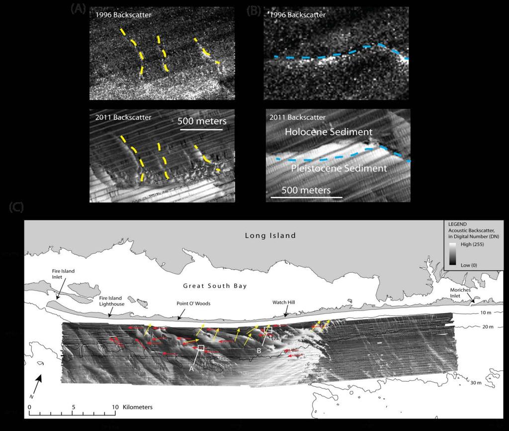
7 Research Capabilities: Offshore bathymetry and geologic framework (A) (B)

8 Research Capabilities: Numerical modeling

9 Research Capabilities: Numerical modeling

10 Research Capabilities: Bayesian modeling

11 Research Capabilities: storm tide monitoring
12 Results of interest to USACE effort Coastal geomorphic changes Conceptual models of sediment transport Coupled numerical modeling strategies Likelihood of barrier island change Extreme subtidal water levels and coastal flooding
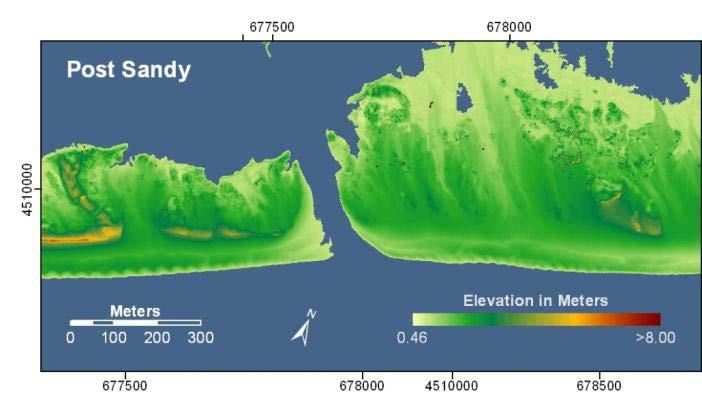
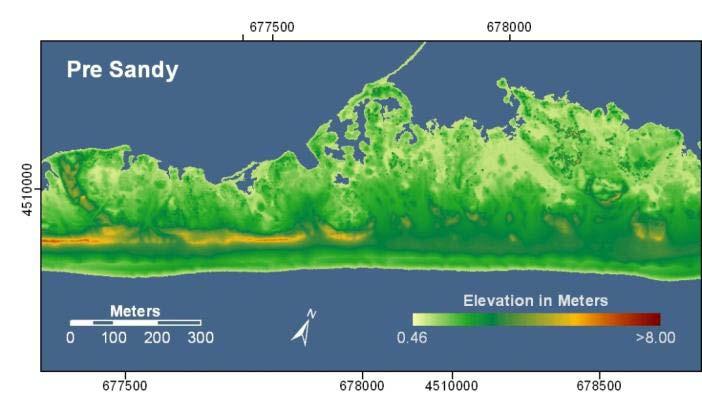
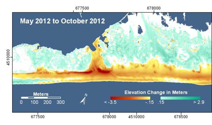
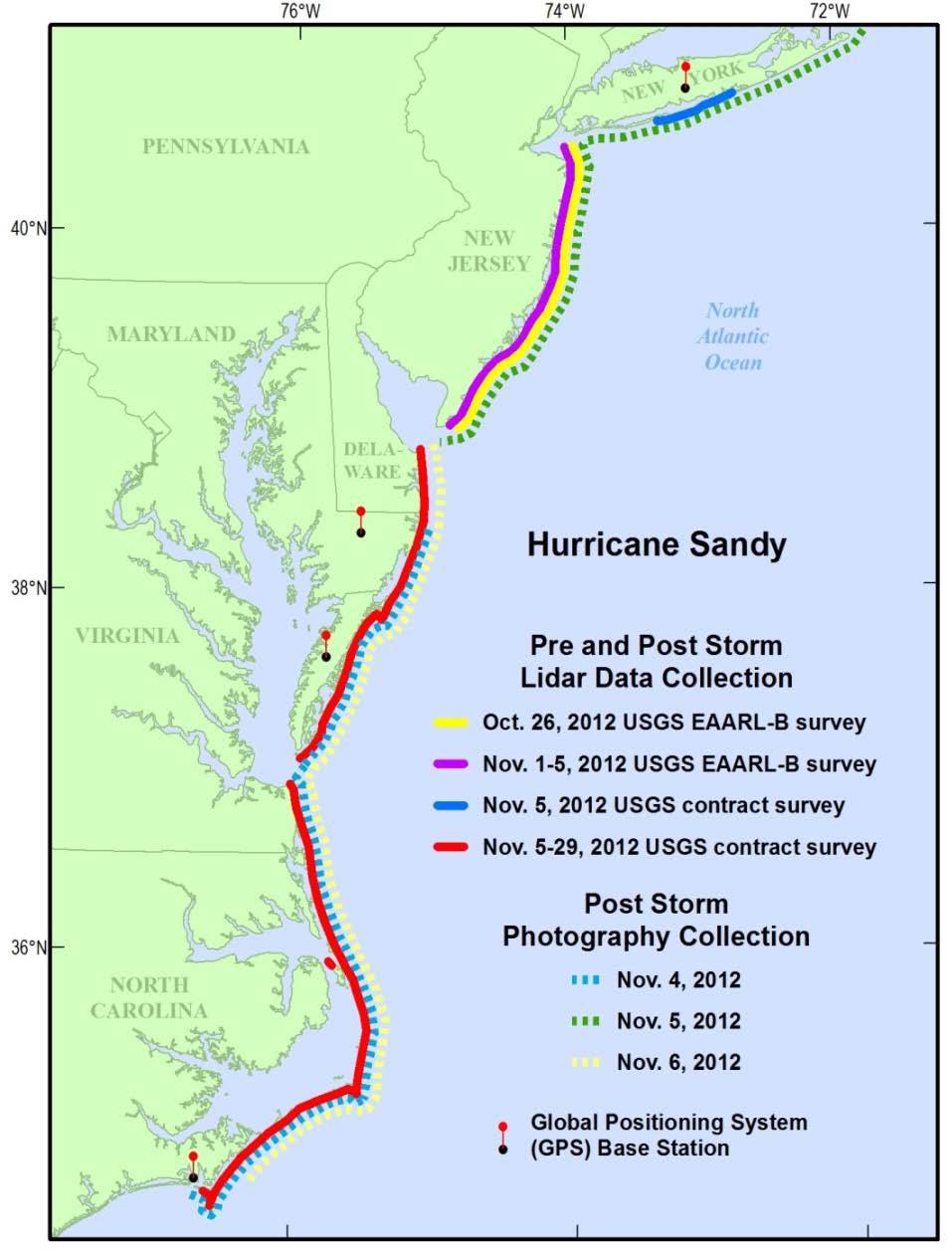
13 Post-Sandy LiDAR collection
14 Results of interest to USACE effort Coastal geomorphic changes Conceptual models of sediment transport Coupled numerical modeling strategies Likelihood of barrier island change Extreme subtidal water levels and coastal flooding
15 Results of interest to USACE effort Coastal geomorphic changes Conceptual models of sediment transport Coupled numerical modeling strategies Likelihood of barrier island change Extreme subtidal water levels and coastal flooding

16 Coupled numerical modeling strategies Importance of passing wave height to atmospheric model

17 Coupled numerical modeling strategies Importance of passing currents to wave model

18 Process-Based Storm Response Model water levels beach/dune morphology offshore wave forcing; water levels XBEACH: High resolution numerical simulation of waves, water levels, overwash, inundation, dune and beach change

19 Hurricane Isaac: Chandeleur Islands, LA Pre-Storm Measured Post-Storm Measured Modeled
20 Results of interest to USACE effort Coastal geomorphic changes Conceptual models of sediment transport Coupled numerical modeling strategies Likelihood of barrier island change Extreme subtidal water levels and coastal flooding
 Inundation (outer) Long Island, NY 93 12 4 New Jersey 98 54 21 Delmarva 91 55 22 New York New Jersey Delaware Maryland")
21 Hurricane Sandy Real-Time Forecast of Coastal Erosion % of coast very likely to experience coastal change : Dune erosion (inner ) Overwash (middle) Inundation (outer) Long Island, NY New Jersey Delmarva New York New Jersey Delaware Maryland Virginia


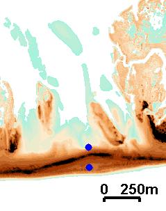
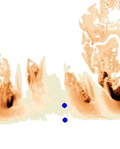
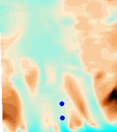
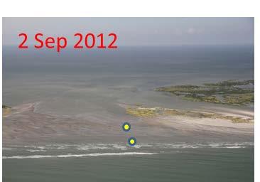
22 Successful prediction of inundation: USGS models indicated a 61% likelihood of inundation at this location on Fire Island. NOAA imagery shows a breach in the island. Fire Island National Seashore, NY EROSION Probability of coastal change Likely As likely as not Unlikely
23 Increased vulnerability to future storms: Pre-Sandy (2010) vulnerability 20% of Fire Island was likely to overwash during Hurricane Sandy. Post-Sandy (2012) vulnerability 70% of Fire Island is likely to overwash during conditions similar to Sandy.


24 Identifying Future Risks Global forcing using the latest climate models Drives global and regional wave models Scaled down to local hazards projections
25 USGS linkages to USACE effort Provide updated topo-bathy data wherever possible Share modeling strategies, forcing data, and assessment data sets (water levels, currents, waves, etc) Provide parallel products to jointly assess coastal vulnerability Share data and model output from regional efforts (Fire Island, Barnegat Bay, Assateague Island)


 H br MSL (datum) SLR only SLR + annual storm")
26 Identifying Future Risks wave run-up wave set-up storm surge seasonal effects tide difference sea level rise h R h wv h ss h se h tide h slr swash zone 2 m m 1.0 m 0.3 m 2 m 1 m breaker zone H decreases rapidly due to breaking d br waves increase in height towards breaking zone (shoaling) H br MSL (datum) SLR only SLR + annual storm Stinson Beach 50 cm SLR
An overview of USGS Hurricane Sandy Supplemental Studies along the Delmarva Peninsula
 An overview of USGS Hurricane Sandy Supplemental Studies along the Delmarva Peninsula Neil K. Ganju, Laura L. Brothers, Nathaniel G. Plant, Christopher G. Smith, E. Robert Thieler Coastal and Marine Geology
A process-based approach toward assessing the coastal impact of projected sea level rise and severe storms
 A process-based approach toward assessing the coastal impact of projected sea level rise and severe storms Patrick Barnard 1, Cheryl Hapke 2, Li Erikson 1, Amy Foxgrover 1, and Maarten van Ormondt 3 1
Geology Setting Management Options Management Structure
 Geology Setting Management Options Management Structure WFF = Wallops Flight Facility LST = Longshore sediment transport SLR = Sea level rise September 29, 2015 Accomack County/Accomack Northampton County
COASTAL EVOLUTION AND CLIMATE CHANGE: CHALLENGES OF MULTI-SCALE SPATIAL AND TEMPORAL VARIABILITY
 COASTAL EVOLUTION AND CLIMATE CHANGE: CHALLENGES OF MULTI-SCALE SPATIAL AND TEMPORAL VARIABILITY Dr. Jennifer L. Miselis Naval Research Laboratory Stennis Space Center, MS jmiselis@nrlssc.navy.mil 1 PRIMARY
JALBTCX AND THE USACE NATIONAL COASTAL MAPPING PROGRAM
 JALBTCX AND THE USACE NATIONAL COASTAL MAPPING PROGRAM 237 237 237 217 217 217 200 200 200 80 119 27 252 174.59 1 255 255 255 0 0 0 163 163 163 131 132 122 239 65 53 110 135 120 112 92 56 62 102 130 102
Summary Visualizations for Coastal Spatial Temporal Dynamics
 Summary Visualizations for Coastal Spatial Temporal Dynamics October 24 2011 Providence, RI Sidharth Thakur 1, Laura Tateosian 2, Helena Mitasova, Eric Hardin, and Margery Overton 1. sthakur@renci.org,
Impacts of Hurricane Rita on the Beaches of Western Louisiana
 Impacts of Hurricane Rita on the Beaches of Western Louisiana By Hilary F. Stockdon, Laura A. Fauver, Asbury H. Sallenger, Jr., and C. Wayne Wright Hurricane Rita made landfall as a category 3 storm in
Some Thoughts on the Role of Elevation
 Some Thoughts on the Role of Elevation Data in Sea-level Rise Impact Assessments Rob Thieler* U.S. Geological Survey Coastal and Marine Geology Program Woods Hole, MA *i l d t i l d f D C h D G h *includes
Sea-level Rise on Cape Cod: How Vulnerable Are We? Rob Thieler U.S. Geological Survey Woods Hole, MA
 Sea-level Rise on Cape Cod: How Vulnerable Are We? Rob Thieler U.S. Geological Survey Woods Hole, MA Outline Sea-level and coastal processes Past sea-level change Predictions for the future Coastal responses
Regional-scale understanding of the geologic character and sand resources of the Atlantic inner continental shelf, Maine to Virginia
 Regional-scale understanding of the geologic character and sand resources of the Atlantic inner continental shelf, Maine to Virginia Workshop on Dredging, Beach Nourishment and Bird Conservation Atlantic
Extreme Changes to Barrier Islands Along the Central Gulf of Mexico Coast During Hurricane Katrina
 Extreme Changes to Barrier Islands Along the Central Gulf of Mexico Coast During Hurricane Katrina By Asbury Sallenger, Wayne Wright, Jeff Lillycrop, Peter Howd, Hilary Stockdon, Kristy Guy, and Karen
Developing Long-Term Coastal Erosion Hazard Maps ASFPM Conference Seattle, WA
 ASFPM 2014 Annual Conference Developing Long-Term Coastal Erosion Hazard Maps ASFPM Conference Seattle, WA Jeremy Mull, P.E. Elena Drei-Horgan, Ph.D. June 5 th, 2014 Presentation Outline Overview of Great
Mapping of Future Coastal Hazards. for Southern California. January 7th, David Revell, Ph.D. E.
 Mapping of Future Coastal Hazards for Southern California January 7th, 2014 David Revell, Ph.D. drevell@esassoc.com E. Vandebroek, 2012 Outline Coastal erosion hazard zones Flood hazard zones: Coastal
Modeling Coastal Change Using GIS Technology
 Emily Scott NRS 509 Final Report December 5, 2013 Modeling Coastal Change Using GIS Technology In the past few decades, coastal communities around the world are being threatened by accelerating rates of
Coastal Inlets Research Program US Army Corps of Engineers Engineering Research and Development Center
 Coastal Inlets Research Program US Army Corps of Engineers Engineering Research and Development Center Site of Moriches Inlet Nov. 1951 Julie Dean Rosati and Nicholas C. Kraus, CIRP Program Manager Shinnecock
The Field Research Facility, Duck, NC Warming Ocean Observations and Forecast of Effects
 The Field Research Facility, Duck, NC Warming Ocean Observations and Forecast of Effects A potential consequence of a warming ocean is more frequent and more intense wind events (Hurricanes & Typhoons)
North Atlantic Coast Comprehensive Study (NACCS) APPENDIX A: ENGINEERING
 APPENDIX A: ENGINEERING") North Atlantic Coast Comprehensive Study (NACCS) APPENDIX A: ENGINEERING NORTH ATLANTIC COAST COMPREHENSIVE STUDY: RESILIENT ADAPTATION TO INCREASING RISK Appendix A - Engineering Table of Contents North
North Atlantic Coast Comprehensive Study (NACCS) APPENDIX A: ENGINEERING NORTH ATLANTIC COAST COMPREHENSIVE STUDY: RESILIENT ADAPTATION TO INCREASING RISK Appendix A - Engineering Table of Contents North
Development of a coastal modeling system
 Development of a coastal modeling system John Warner US Geological Survey Coastal and Marine Geology Program Woods Hole, MA U.S. Department of the Interior U.S. Geological Survey Jeff List Rob Thieler
The use of MIKE21 to study the. barrier beach system of Inner Dingle Bay, Co. Kerry, Ireland. Dr. Michael O Shea Malachy Walsh and Partners
 The use of MIKE21 to study the morphodynamic evolution of the mid-bay barrier beach system of Inner Dingle Bay, Co. Kerry, Ireland Dr. Michael O Shea Malachy Walsh and Partners Contents Why Study Morphodynamics
Primer on Coastal Erosion And Habitat Creation
 2 nd Regional Conference Dredging, Beach Nourishment & Bird Conservation Primer on Coastal Erosion And Habitat Creation Timothy Kana Ph.D Source: Newsday 1962 Photo by Kelsey Aerials 1978 Source: U Mass
Australian Coastal Councils Conference
 Australian Coastal Councils Conference 11 March 2015 Estimating Future Coastal Inundation and Erosion Hazards Dr Andrew McCowan Dr Christine Lauchlan-Arrowsmith Warwick Bishop Background Victorian Future
USING MIKE TO MODEL COASTAL CATASTROPHE RISK
 USING MIKE TO MODEL COASTAL CATASTROPHE RISK Nicola Howe, Christopher Thomas, Joss Matthewman, John Maskell* 1 SUMMARY About RMS Who are we and what do we do? How do we use MIKE in our workflow? Case study:
Importance of Understanding Coastal Landforms
 Importance of Understanding Coastal Landforms Costa Concordia Shipwreck, Isola del Giglio, Italy Depositional Coastal Landforms Can interpret landforms in light of geomorphic processes, both terrestrial
Mapping Coastal Change Using LiDAR and Multispectral Imagery
 Mapping Coastal Change Using LiDAR and Multispectral Imagery Contributor: Patrick Collins, Technical Solutions Engineer Presented by TABLE OF CONTENTS Introduction... 1 Coastal Change... 1 Mapping Coastal
Geol 117 Lecture 18 Beaches & Coastlines. I. Types of Coastlines A. Definition:
 I. Types of Coastlines A. Definition: 1. Shore = narrow zone where ocean meets land (e.g. beach) 2. Coast is a broad area where both ocean and land processes act a. Includes onshore marshes, dunes, sea
Analysis of Tides and Storm Surge from Observational Records in the Delaware Inland Bays
 Analysis of Tides and Storm Surge from Observational Records in the Delaware Inland Bays John Callahan Delaware Geological Survey Coastal GeoTools Conference March 30 April 2, 2015 Charleston, SC Outline
Preliminary Vulnerability Assessment of Coastal Flooding Threats - Taylor County, Florida
 Preliminary Vulnerability Assessment of Coastal Flooding Threats - Taylor County, Florida North Central Florida Regional Planning Council Northeast Florida Regional Council April 28, 2016 BACKGROUND This
The Marine Environment
 The Marine Environment SECTION 16.1 Shoreline Features In your textbook, read about erosional landforms, beaches, estuaries, longshore currents, and rip currents. For each statement below, write or. 1.
Probabilistic prediction of barrier-island response to hurricanes
 JOURNAL OF GEOPHYSICAL RESEARCH, VOL. 117,, doi:10.1029/2011jf002326, 2012 Probabilistic prediction of barrier-island response to hurricanes Nathaniel G. Plant 1 and Hilary F. Stockdon 1 Received 4 January
Impact of Changes in Morphology on Extent and Duration of Inundation during Tropical Cyclones
 DISTRIBUTION STATEMENT A. Approved for public release; distribution is unlimited. Impact of Changes in Morphology on Extent and Duration of Inundation during Tropical Cyclones Jayaram Veeramony Code 7322,
The Marine Environment
 The Marine Environment SECTION 16.1 Shoreline Features In your textbook, read about erosional landforms, beaches, estuaries, longshore currents, and rip currents. For each statement below, write true or
Draft for Discussion 11/11/2016
 Coastal Risk Consulting (CRC) Climate Vulnerability Assessment for Village of Key Biscayne Deliverable 1.1 in Statement of Work. Preliminary Vulnerability Assessment Identifying Flood Hotspots Introduction...
Lab 12 Coastal Geology
 Lab 12 Coastal Geology I. Fluvial Systems Hydrologic Cycle Runoff that flows into rivers = precipitation (rain and snowmelt) [infiltration (loss to groundwater) + evaporation (loss to atmosphere) + transpiration
Adaptation to Sea Level Rise A Regional Approach
 Adaptation to Sea Level Rise A Regional Approach Project Partners: in Saco Bay, ME Peter Slovinsky, Marine Geologist Maine Geological Survey, Department of Conservation Project Funding from: Saco Bay Hazards
Sea-level Rise and Storm Effects on Coastal Systems under Changing Global Climate. Cape May, NJ 12 January 2009
 Sea-level Rise and Storm Effects on Coastal Systems under Changing Global Climate 2009 Delaware Estuary Science Summit Cape May, NJ 12 January 2009 S. Jeffress Williams Senior Coastal Marine Geologist
National Assessment of Hurricane-Induced Coastal Erosion Hazards: Southeast Atlantic Coast
 National Assessment of Hurricane-Induced Coastal Erosion Hazards: Southeast Atlantic Coast By Hilary F. Stockdon, Kara J. Doran, David M. Thompson, Kristin L. Sopkin, and Nathaniel G. Plant Open-File Report
Coastal Zone Mapping and Imaging Lidar (CZMIL)
") Coastal Zone Mapping (CZMIL) Shallow Survey 2012 Wellington, New Zealand Christopher L. Macon U.S. Army Corps of Engineers, Mobile District Joint Airborne Lidar Bathymetry Technical Center of expertise
Coastal Zone Mapping (CZMIL) Shallow Survey 2012 Wellington, New Zealand Christopher L. Macon U.S. Army Corps of Engineers, Mobile District Joint Airborne Lidar Bathymetry Technical Center of expertise
GenCade. Combining and Extending the GENESIS and Cascade Models for Planning and Design in a Regional Sediment Management Framework
 GenCade Combining and Extending the GENESIS and Cascade Models for Planning and Design in a Regional Sediment Management Framework G Presented by Nicholas C. Kraus For the GenCade Development Team Ken
Critical Issues in Assessment of Offshore Wind Farm Development on Dispersion and Settling of Scallop Larvae in the Northeast U.S.
 Critical Issues in Assessment of Offshore Wind Farm Development on Dispersion and Settling of Scallop Larvae in the Northeast U.S. Coastal Ocean Changsheng Chen School for Marine Science and Technology
Development of Operational Storm Surge Guidance to Support Total Water Predictions
 Development of Operational Storm Surge Guidance to Support Total Water Predictions J. Feyen 1, S. Vinogradov 1,2, T. Asher 3, J. Halgren 4, Y. Funakoshi 1,5 1. NOAA/NOS//Development Laboratory 2. ERT,
Coastal Cities-Coastal Impacts: 'The Tides They Are A-Changin
 Coastal Cities-Coastal Impacts: 'The Tides They Are A-Changin Susan K. Avery Woods Hole Oceanographic Institution Thanks to: Jeff Donnelly, Chris Reddy, Porter Hoagland, Jim Price, Dennis McGillicuddy,
Hurricane Matthew Threats and Impacts Briefing for Eastern NC
 Hurricane Matthew Threats and Impacts Briefing for Eastern NC October 6 th, 2016 Date/Time Created: 10/6/2016, Noon EDT National Weather Service Newport/Morehead City, NC Hurricane Matthew Key Points Changes
RISC-KIT: EWS-DSS Hotspot Tool
 RISC-KIT: EWS-DSS Hotspot Tool Robert McCall Ap van Dongeren Deltares www.risckit.eu This project has received funding from the European Union s Seventh Programme for Research, Technological Development
Donald K. Stauble and Bill Birkemeier Coastal and Hydraulics Laboratory US Army Corps of Engineers
 Donald K. Stauble and Bill Birkemeier Coastal and Hydraulics Laboratory US Army Corps of Engineers Define the Problem Navigation Shore Protection Environmental Political So what is the problem? Management
Tony Pratt, DNREC to The Center for the Inland Bays Scientific and Technical Advisory Committee. August 21, 2009
 Sea Level Rise in Delaware Presented by Tony Pratt, DNREC to The Center for the Inland Bays Scientific and Technical Advisory Committee August 21, 2009 Sea level has been fluctuating ever since there have
THE INFLUENCE OF WASHOVER DIMENSIONS AND BEACH CHARACTERISTICS ON THE SEDIMENT TRANSPORT DURING INUNDATION. Abstract
 THE INFLUENCE OF WASHOVER DIMENSIONS AND BEACH CHARACTERISTICS ON THE SEDIMENT TRANSPORT DURING INUNDATION Daan Wesselman 1, Maarten van der Vegt 1 and Renske de Winter 1 Abstract Barrier islands need
STORM IMPACT MODELING ANALYSIS FOR THE RESTORATION OF GULF STATE PARK, AL
 STORM IMPACT MODELING ANALYSIS FOR THE RESTORATION OF GULF STATE PARK, AL Jordon Cheifet, PE, CFM Joao Dobrochinski, MSc Morjana Signorin APTIM Senior Project Engineer APTIM Numerical Modeling Lead APTIM
MONITORING AND MODELING NATURAL AND ANTHROPOGENIC TERRAIN CHANGE
 MONITORING AND MODELING NATURAL AND ANTHROPOGENIC TERRAIN CHANGE Spatial analysis and simulations of impact on landscape processess Helena MITASOVA, Russell S. HARMON, David BERNSTEIN, Jaroslav HOFIERKA,
Monitoring Shoreline Change along Assateague Barrier Island: The First Trend Report
 Journal of Coastal Research SI 64 8-84 ICS211 (Proceedings) Poland ISSN 749-28 Monitoring Shoreline Change along Assateague Barrier Island: The First Trend Report N. P. Psuty and T. M. Silveira Marine
A Multi-Hazard Evaluation of Vulnerability using GIS along Cape Hatteras National Seashore, NC
 A Multi-Hazard Evaluation of Vulnerability using GIS along Cape Hatteras National Seashore, NC Tom Allen¹, Burrell Montz¹, JP Walsh¹, Tom Crawford² ¹East Carolina University, ²Saint Louis University Presented
SLOSH New Orleans Basin 2012 Update
 SLOSH New Orleans Basin 2012 Update Michael Koziara Science and Operations Officer National Weather Service Slidell, LA The Basics What is storm surge? What is SLOSH? Details Assumptions Inundation = Storm
DUNE EROSION NEAR SEA WALLS: MODEL-DATA COMPARISON
 DUNE EROSION NEAR SEA WALLS: MODEL-DATA COMPARISON Pieter van Geer 1, Bram de Vries 2, Ap van Dongeren 1 and Jaap van Thiel de Vries 1,2 This paper describes the validation of the dune erosion model XBeach
Subaqueous Soils A A New Frontier in Soil Survey. By Jim Turenne
 Subaqueous Soils A A New Frontier in Soil Survey By Jim Turenne http://nesoil.com.sas Subaqueous History Traditional soil survey conducted on land. Not a lot of work in wetlands and tidal marshes until
Turn and Face the Strange: Economic Impacts of Climate Change Sea Level Rise and Coastal Flooding E2Tech Forum June 21, 2018
 Turn and Face the Strange: Economic Impacts of Climate Change Sea Level Rise and Coastal Flooding E2Tech Forum June 21, 2018 Peter A. Slovinsky, Marine Geologist Maine Geological Survey Image from Chebeague.org
Storm Surge/Coastal Inundation State of the Union. Jamie Rhome Storm Surge Team Lead NOAA/National Hurricane Center
 Storm Surge/Coastal Inundation State of the Union Jamie Rhome Storm Surge Team Lead NOAA/National Hurricane Center 2 Tampa: Cat 5 Scenario 3 4 The Stakes are High Combination of SLR and increasing coastal
Computing the Joint Probability of Hurricane Sandy and Historical Coastal Storm Forcing Parameters from Maine to Virginia
 Computing the Joint Probability of Hurricane Sandy and Historical Coastal Storm Forcing Parameters from Maine to Virginia Chris Massey and Jeff Melby USACE-ERDC Coastal & Hydraulics Lab Chris.Massey@usace.army.mil
Location: Jacksonville, FL December 11, 2012
 Technical Update Meeting Northeast Florida Surge Study Location: Jacksonville, FL December 11, 2012 Agenda 2:00 2:15 Welcome/Introductions Tucker Mahoney, FEMA Region IV Michael DelCharco, BakerAECOM 2:15
COASTAL DATA APPLICATION
 2015 Coastal GeoTools Proactive By Design. Our Company Commitment COASTAL DATA APPLICATION Projecting Future Coastal Flood Risk for Massachusetts Bay Bin Wang, Tianyi Liu, Daniel Stapleton & Michael Mobile
Storm Induced Coastal Erosion for Flood Insurance Studies and Forecasting Coastal Flood Damage Impacts: Erosion, Runup & Overtopping
 Storm Induced Coastal Erosion for Flood Insurance Studies and Forecasting Coastal Flood Damage Impacts: Erosion, Runup & Overtopping Jeff Gangai- Dewberry Tucker Mahoney FEMA HQ Introduction Background
Oceanography. Oceanography is the study of the deep sea and shallow coastal oceans.
 Oceanography Oceanography is the study of the deep sea and shallow coastal oceans. Studying the Ocean Floor To determine the shape and composition of the ocean floor, scientists use techniques such as
Erich Gundlach, Ph.D.
 Oil Shoreline Interactions: Deepwater Horizon SETAC Boston, November 2011 Erich Gundlach, Ph.D. E-Tech International Inc. New York, USA ErichEti@ cs.com www.oil-spill-info.com What s Going On Shorelines
Latest trends in sea level rise and storm surges in Maine Peter A. Slovinsky, Marine Geologist
 Latest trends in sea level rise and storm surges in Maine Peter A. Slovinsky, Marine Geologist Image from Chebeague.org Maine s glacial geology and historic sea level rise trends Current sea level trends
5/25/2017. What is projected for Coastal texas? PROTECTING CRITICAL WATER INFRASTRUCTURE FROM SEA LEVEL RISE
 PROTECTING CRITICAL WATER INFRASTRUCTURE FROM SEA LEVEL RISE What is projected for Coastal texas? Mean Sea Level has risen 3 18 to 37 above Mean Sea Level 1800-1992 1992-2015 2030 2060 2100 Mean Sea Level
Earth-Space Science 6 12
 Earth-Space Science 6 12 Section 08 1 Knowledge of the nature of science 1. Identify the components of scientific inquiry. 2. Identify the consistent patterns that govern the occurrence of most natural
Queensland Storm Surge Forecasting Model Design Using Sensitivity Analysis
 21st International Congress on Modelling and Simulation, Gold Coast, Australia, 29 Nov to 4 Dec 215 www.mssanz.org.au/modsim215 Queensland Storm Surge Forecasting Model Design Using Sensitivity Analysis
The Coast: Beaches and Shoreline Processes Trujillo & Thurman, Chapter 10
 The Coast: es and Shoreline Processes Trujillo & Thurman, Chapter 10 Oceanography 101 Chapter Objectives Recognize the various landforms characteristic of beaches and coastal regions. Identify seasonal
Forecast of Nearshore Wave Parameters Using MIKE-21 Spectral Wave Model
 Forecast of Nearshore Wave Parameters Using MIKE-21 Spectral Wave Model Felix Jose 1 and Gregory W. Stone 2 1 Coastal Studies Institute, Louisiana State University, Baton Rouge, LA 70803 2 Coastal Studies
The Coast: Beaches and Shoreline Processes
 1 2 3 4 5 6 7 8 9 The Coast: es and Shoreline Processes Trujillo & Thurman, Chapter 10 Oceanography 101 Chapter Objectives Recognize the various landforms characteristic of beaches and coastal regions.
SAGE. Systems Approach to Geomorphic Engineering. Barnegat Bay Pilot. Heather Jensen Philadelphia District. US Army Corps of Engineers BUILDING STRONG
 SAGE Systems Approach to Geomorphic Engineering Barnegat Bay Pilot Heather Jensen Philadelphia District US Army Corps of Engineers SAGE Nationwide program with a Regional Approach Innovative approach to
The Science of Sea Level Rise and the Impact of the Gulf Stream
 Old Dominion University ODU Digital Commons July 29, 2016: The Latest in Sea Level Rise Science Hampton Roads Sea Level Rise/Flooding Adaptation Forum 7-29-2016 The Science of Sea Level Rise and the Impact
Climate Change Impacts and Adaptation for Coastal Transport Infrastructure in Caribbean SIDS
 UNCTAD National Workshop Saint Lucia 24 26 May 2017, Rodney Bay, Saint Lucia Climate Change Impacts and Adaptation for Coastal Transport Infrastructure in Caribbean SIDS LISCoAsT Large Scale Integrated
Current and Future Technology Applications for Coastal Zone Management. Bruce K. Carlisle, Acting Director Office of Coastal Zone Management
 Current and Future Technology Applications for Coastal Zone Management Bruce K. Carlisle, Acting Director Office of Coastal Zone Management The Massachusetts Coastal Zone Management Program Approved in
HURRICANE IRENE. CONFERENCE CALL BRIEFING SLIDES Saturday August 27, :30 AM
 HURRICANE IRENE CONFERENCE CALL BRIEFING SLIDES Saturday August 27, 2011 8:30 AM NHC TRACK AND CONE HURRICANE IRENE WATCHES/WARNINGS Hurricane Warning along south coast including all of Cape Cod and Islands
NOAA s National Ocean Service. Center for Operational Oceanographic Products and Services
 NOAA s National Ocean Service Center for Operational Oceanographic Products and Services Richard Edwing, CO-OPS Acting Director January 27, 2010 Outline CO-OPS Overview Programs Observing Systems PORTS
GLY Coastal Geomorphology Notes
 GLY 4734 - Coastal Geomorphology Notes Dr. Peter N. Adams Spring 2011 2 Coastal Classification In this lecture, we discuss some successful classification schemes of the coastal landscape, and pay particular
MARINE GEOLOGY & GEOGRAPHY
 MARINE GEOLOGY MARINE GEOLOGY & GEOGRAPHY Marine Geology 4 LAYERS OF THE EARTH CRUST THICKNESS: VARIES BETWEEN OCEAN & CONTINENTS 5-40 KM STATE: SOLID ELEMENTS: SILICON, ALUMINUM, CALCIUM, SODIUM, POTASSIUM
MARINE GEOLOGY & GEOGRAPHY
 MARINE GEOLOGY & GEOGRAPHY Bathymetry BATHYMETRY BATHYMETRY THE UNDERWATER EQUIVALENT TO TOPOGRAPHY THE STUDY OF WATER DEPTH A BATHYMETRIC MAP SHOWS FLOOR RELIEF OR TERRAIN AS CONTOUR LINES Bathymetry
Phillip Island Nature Parks Coastal Process Study 8 October 2014
 Phillip Island Nature Parks Coastal Process Study 8 October 2014 Project Overview Coastal Geology Basaltic and fragmented lavas, granite at Pyramid Rock and Cape Woolamai Weathered basalt (>10m thick)
Landslide & Coastal Erosion Risk Reduction at Oregon s Water/Wastewater Networks
 Landslide & Coastal Erosion Risk Reduction at Oregon s Water/Wastewater Networks Laura Gabel, RG (with Bill Burns, RG & Jonathan Allan, Ph. D) Oregon Department of Geology and Mineral Industries (541)
EVALUATION TECHNIQUES FOR THE PROTECTIVE BENEFITS OF DUNE SYSTEMS TO COASTAL HAZARDS
 EVALUATION TECHNIQUES FOR THE PROTECTIVE BENEFITS OF DUNE SYSTEMS TO COASTAL HAZARDS 5 th Coastal Hazards Symposium Key West 2015 Matthew Janssen Thomas Herrington Jon Miller 1 Abstract Quantify and predict
Angelica Murdukhayeva NRS509 Report Fall 2010 GIS and Coastal Environments
 Angelica Murdukhayeva NRS509 Report Fall 2010 GIS and Coastal Environments The coastal zone contains unique natural resources that are critical to biological and economic productivity. It is also subject
CHAPTER 1 INTRODUCTION
 1 CHAPTER 1 INTRODUCTION 1.1 GENERAL Washover sandsheets are often found in low-lying coastal embayment s (Sedgwick and Davis 2003). Washover deposition of marine sand is usually attributed to storm activity
Modeling hurricane impacts on beaches, dunes and barrier islands
 Modeling hurricane impacts on beaches, dunes and barrier islands Dano Roelvink, Ad Reniers, Ap van Dongeren, Jaap van Thiel de Vries, Jamie Lescinski, Dirk-Jan Walstra Motivation 2004 Hurricane season
Modeling multiple sea level rise stresses reveals up to twice the land at risk compared to strictly passive flooding methods
 www.nature.com/scientificreports Received: 1 June 2018 Accepted: 12 September 2018 Published: xx xx xxxx OPEN Modeling multiple sea level rise stresses reveals up to twice the land at risk compared to
Impact of Sea Level Rise on Future Storm-induced Coastal Inundation
 Impact of Sea Level Rise on Future Storm-induced Coastal Inundation Changsheng Chen School for Marine Science and Technology, University of Massachusetts-Dartmouth Email: c1chen@umassd.edu 04/14/2015 Outline
Town of Old Orchard Beach: A summary of sea level rise science, storm surge, and some highlighted results from SLAWG work efforts
 Town of Old Orchard Beach: A summary of sea level rise science, storm surge, and some highlighted results from SLAWG work efforts October 15, 2013 Peter A. Slovinsky, Marine Geologist Maine Geological
Hurricane Harvey: Texas Coastal Erosion Hot Spot Analysis
 Hurricane Harvey: Texas Coastal Erosion Hot Spot Analysis Texas ASBPA Symposium April 24, 2018 Alan Johnson, FEMA Chris Levitz, Compass Agenda Introduction Hurricane Harvey Erosion Hot Spot Analysis Purpose
Adapting to Rising Sea Level & Extreme Weather Events:
 Adapting to Rising Sea Level g & Extreme Weather Events: A Florida Perspective Randall W. Parkinson, Ph.D., P.G. President RWParkinson Consulting, Inc. Melbourne, Florida & Administrator Space Coast Climate
Miami-Dade County Technical Update Meeting South Florida Coastal Study. May 11, 2016
 Miami-Dade County Technical Update Meeting South Florida Coastal Study May 11, 2016 Welcome and Introductions FEMA Region IV Christina Lindemer Technical Lead Production and Technical Services (PTS) Contractor
Flood and Sea Level Rise Mapping Methodologies: The Way Forward
 Flood and Sea Level Rise Mapping Methodologies: The Way Forward Malcolm L. Spaulding Professor Emeritus, Ocean Engineering University of Rhode Island spaulding@egr.uri.edu Interagency Coordination Meeting
Coastal Erosion Risks - Beaches. Objectives
 Coastal Erosion Risks - Beaches Risk Management in Civil Engineering, Advanced Course Lisbon, November 21 st, 2008 Objectives To briefly introduce coastal processes governing sediment transport and beach
SHORELINE AND BEACH PROCESSES: PART 2. Implications for Coastal Engineering
 SHORELINE AND BEACH PROCESSES: PART 2 Implications for Coastal Engineering Objectives of the lecture: Part 2 Show examples of coastal engineering Discuss the practical difficulties of ocean engineering
Regional Sediment Management
 Regional Sediment Management Linda S. Lillycrop Program Manager Coastal Engineer US Army Engineer Research and Development Center Coastal and Hydraulics Laboratory Q AVG Coastal Resilience: The Environmental,
HAZUS th Annual Conference
 HAZUS 2014 7 th Annual Conference VALIDATING THE HAZUS COASTAL SURGE MODEL FOR SUPERSTORM SANDY Spiridon Katehis 1 Jordan T. Hastings 1 1 University of Southern California 1 Superstorm Sandy, Oct 12 2
XBeach modeling at various temporal and spatial scales
 //oss.deltares.nl/web/xbeach XBeach modeling at various temporal and spatial scales Ad Reniers, RSMAS, UM : Impact of time and process scales XBeach modeling concepts avalanching dune Wave groups c g Bound
MISSISSIPPI COASTAL IMPROVEMENTS
 MISSISSIPPI COASTAL IMPROVEMENTS PROGRAM (MsCIP) Comprehensive Barrier 237 27 200 237 27 200 Island 237 Restoration 27 200 Plan 80 9 27 252 74.59 255 255 255 0 0 0 63 63 63 3 32 22 239 65 53 0 35 20 2
A Detailed First Pass coastal hazard assessment for a long complex coast: Kingborough LGA, Tasmania
 A Detailed First Pass coastal hazard assessment for a long complex coast: Kingborough LGA, Tasmania Chris Sharples & Paul Donaldson University of Tasmania September 2012 Kingborough LGA, south-eastern
WP4: COASTAL PROCESSES
 WP4: COASTAL PROCESSES Coordinator: G. EBERHARDS Faculty of Geography and Earth Sciences, University of Latvia Daugavpils, 2008 Goal: The objective of this study is analysis of coastal changes and forecast
A Perfect Storm: The Collision of Tropical Cyclones, Climate Change and Coastal Population Growth. Jeff Donnelly Woods Hole Oceanographic Institution
 A Perfect Storm: The Collision of Tropical Cyclones, Climate Change and Coastal Population Growth Jeff Donnelly Woods Hole Oceanographic Institution Recent Hurricane Trends What Might the Future Hold?
Applications of GIS in assessing Coastal Change Rachel Hehre November 30, 2004 NRS 509 OVERVIEW
 Applications of GIS in assessing Coastal Change Rachel Hehre November 30, 2004 NRS 509 OVERVIEW ITRODUCTION Due to the dynamic nature of coastal systems, representing coastal change with precision and