Subaqueous Soils A A New Frontier in Soil Survey. By Jim Turenne
|
|
|
- Patience Hancock
- 6 years ago
- Views:
Transcription

1 Subaqueous Soils A A New Frontier in Soil Survey By Jim Turenne

2 Subaqueous History Traditional soil survey conducted on land. Not a lot of work in wetlands and tidal marshes until the 70 s. In 1993 Submerged Soils: A New Frontier in Soil Survey by George Demas published in Soil Survey Horizons. Most work in Chesapeake Bay Region Maryland/Delaware. George pioneered the concept of Subaqueous Soils differentiating them from sediment. George Demas


3 Is it Soil or Sediment? Qualifying Criteria: 1. Supplies nutrients to plants 2. Forms horizons in place Eel Grass
![Definition of Soil Soil is a natural body that occurs on the land surface, and is characterized by [either] 1.](/docs-images/77/75240991/images/4-0.jpg "Horizons, or layers, that are distinguishable from the initial material as a result of additions, losses, transfers, and transformations of energy and matter or 2.")
4 Definition of Soil Soil is a natural body that occurs on the land surface, and is characterized by [either] 1. Horizons, or layers, that are distinguishable from the initial material as a result of additions, losses, transfers, and transformations of energy and matter or 2. The ability to support rooted plants in a natural environment.
![Definition of Soil The upper limit of soil is the boundary between soil and air [or] shallow water [not] too deep (typically more than 2.](/docs-images/77/75240991/images/5-0.jpg "5 m*) for the growth of rooted plants. Added to Soil Taxonomy in 1999 as a result of work in Maryland/Delaware.")
5 Definition of Soil The upper limit of soil is the boundary between soil and air [or] shallow water [not] too deep (typically more than 2.5 m*) for the growth of rooted plants. Added to Soil Taxonomy in 1999 as a result of work in Maryland/Delaware. *Arbitrary Arbitrary depth set as a cut-off for soil survey. Cowardin Wetlands Classification
6 Factors of Subaqueous Soil Formation Combination of Jenny s s soil forming factors and Folger s sediment genesis factors: Ss = f(c,, O, B, F, P, T, W, CE) Ss = subaqueous soil C = Climate/temp. O = Organisms B = Bathymetry F = Flow Regime P = Parent Material T = Time W = Water column attributes CE = Catastrophic events Demas, Rabenhorst. 2001Factors of Subaqueous Soil Formation.
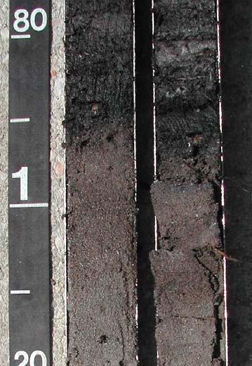
. Numerous buried A and O horizons.")
7 Soil Formation: Soil Horizons Organic (O) and mineral (A and C) horizons. Predominantly dealing with AC type soils (Entisols). Numerous buried A and O horizons. Some subaqueous and submerged soils have buried B horizons.


8
9 Soil Formation: Additions/Losses/Transfers Additions Additions of mineral sediments alluvial deposits. Biological additions shells, organisms. Anthropogenic additions dredge material, mechanical disturbance. Losses Erosion losses wave and storm losses, tidal currents. Decomposition of organic matter. Transfers Diffusion hi to low concentrations. Bioturbation. Bottom Line: Shallow Water Environments can best be studied as SOIL!
10 Significance and Value of Subaqueous Soil Inventory Sediment characteristics presented to a greater depth (2 m), rather than a surficial approach. Provides a comprehensive classification scheme (Soil Taxonomy, SSM) for shallow water sediments. Could provide a major or missing data set for SAV restoration, estuarine protection, planning and management. NRCS responsibility to inventory soils.
11 Specific Soil Based Interpretations SAV Restoration Crab Habitat Clam Stocking Management for Sustainable Shellfish Production Nutrient Reduction Pathogens Pfesteria Cyst Residence Sites Benthic Preservation Site Identification Wildlife Management Wading Shore Birds, Migratory Waterfowl, Nurseries and Spawning Areas Habitat Protection for Horseshoe Crab and Diamondback Terrapin Dredging Island Creation Tidal Marsh Protection and Creation Bathymetric Map Navigational Channel Creation/Maintenance Effects of Dredging on Benthic Ecology Off Site Disposal of Dredge Spoil Acid-Sulfate Weathering Hazards Dune and Beach Maintenance/Replenishment Carbon Sequestration
12 Users of Subaqueous soil survey data for specific resource Management (Phil King Delaware NRCS). Resource Managers US-EPA, MD-DNR, MDE Chesapeake Bay Program DE Inland Bay Program Maryland Coastal Bays Program Egg Harbor, NJ Baltimore Harbor/Bay Dredging US-ACE US-ACE, US-DI Pamlico-Albermarle Sound NEP Program NOAA US-ACE, MD-DNR, Wor SWCD, DI Assateague Island National Park Private Aquaculture Industry Shellfish Harvest Industry NRCS, RCD, DE CIB, DNREC DE Sierra Club DNREC
13 Subaqueous Mapping Procedure Need to develop a bathymetric map which is used for subaqueous landform identification. Can use existing NOAA charts (order 3 mapping) or create detailed bathymetry using fathometer and survey equipment. Remote sensing including LIDAR, Side Scan Sonar, GPR (freshwater only), RTK GPS.
14

15 Shoal Mainland Submerged Beach Barrier Cove Barrier Submerged Beach


16 Storm Surge Washover Flat Flood Tidal Delta Slope Flood Tidal Delta Flat Storm Surge Washover Flat GLOSSARY OF TERMS FOR SUBAQUEOUS SOILS, ASSOCIATED LANDSCAPES, LANDFORMS, AND RELATED MATERIALS
17 Subaqueous Soil Mapping Procedure Develop subaqueous soil series and map unit Legend. Identify and delineate landforms to determine soil map unit breaks. Map the area using standard NCSS procedure. Bucket augers and McCauley peat corers are used to investigate morphology. Vibracore techniques are used for deep and detailed observations. Determine map unit composition, inclusions, ROC, and other information compile map.
18 Problems/Considerations Difficult mapping conditions and procedure (augering in water, describing profiles, etc.). Need inter-discipline collaboration (coastal geology, marine ecology, biologist, etc.). Alluvial soils are very variable and subject to change (seasonal and long term). Seasonal mapping (bathymetry year round). Safety concerns (weather, boating, environmental). Requires some additional equipment, storage space, and maintenance.
19 Final Product Soil Survey of Coastal, Subaqueous and Submerged Soils of MLRA s s 144A, 149B (MO (MO-12) Maps showing the spatial distribution. Manuscript: 1. Description of the soils. 2. Formation, genesis, classification. 3. Use, interpretations, and management ecological, fisheries, SAV, engineering, hazards, etc.
 sand flats of the flood-tidal delta.")

20 Date: 9/18/00 Sample: VBG Mapping Unit: Glacial Fluvial Point Bar Location Description: East of Grassy point Vibra-Core Depth 51 cm. Notes: Live quohog at 5-10 cm. Ftd Flood-tidal Delta Flat, sand flats: These soils are found on the very shallow (<1.1 m) sand flats of the flood-tidal delta. The subaqueous soils of this unit are characterized by black, very dark gray, and dark gray, sands with low (<0.5%) amounts of organic carbon. Buried horizons and stratification are occasionally identified. Most soils are classified as Typic Psammaquents. Submerged topography is flat or slightly undulating. Remnant and active channels are common inclusions in this unit. Eelgrass is virtually absent

21 Terrestrial Soil Survey
22 Seamless Soil Survey


23 Bathymetry Vibracore

24 Hand Tools


25

26 END Visit: for more information
Introduction to Subaqueous Soils and MapCoast. James D. Turenne Assistant State Soil Scientist Rhode Island (The Ocean State) USDA-NRCS
 USDA-NRCS") Introduction to Subaqueous Soils and MapCoast. James D. Turenne Assistant State Soil Scientist Rhode Island (The Ocean State) USDA-NRCS Subaqueous History Traditional soil survey conducted on land. Not
Introduction to Subaqueous Soils and MapCoast. James D. Turenne Assistant State Soil Scientist Rhode Island (The Ocean State) USDA-NRCS Subaqueous History Traditional soil survey conducted on land. Not
NCSS Soil Survey Updates & Intro to Coastal Zone and Subaqueous Soil Data
 NCSS Soil Survey Updates & Intro to Coastal Zone and Subaqueous Soil Data Jim Turenne, CPSS Assistant State Soil Scientist RI USDA NRCS http://nesoil.com/sas and www.mapcoast.org Digital Soils Data CT,
Developing Soil Maps and Interpretations for Shallow Subtidal Habitats
 Developing Soil Maps and Interpretations for Shallow Subtidal Habitats James D. Turenne Assistant State Soil Scientist Rhode Island (The Ocean State) USDA-NRCS Narragansett Bay Estuary LNB Coastal Lagoons
Sediment Management in the Coastal Bays
 Sediment Management in the Coastal Bays Introduction Need for ecosystem view of sediment management in Coastal Bays Island loss and restoration Navigation needs Habitat Trade offs Living Shoreline Requirements
Subaqueous Landforms, Features, and Materials ( much content from Jim Turenne, NRCS, & Mark Stolt, URI )
") Subaqueous Landforms, Features, and Materials ( much content from Jim Turenne, NRCS, & Mark Stolt, URI ) 1) Discrete underwater features or geoforms (that commonly can support rooted plants), and adjacent
Subaqueous Landforms, Features, and Materials ( much content from Jim Turenne, NRCS, & Mark Stolt, URI ) 1) Discrete underwater features or geoforms (that commonly can support rooted plants), and adjacent
Quantifying effects of oil on coastal dune vegetation. Thomas Miller and Elise Gornish Biological Science, Florida State University
 Quantifying effects of oil on coastal dune vegetation Thomas Miller and Elise Gornish Biological Science, Florida State University Natural History of Barrier Islands in the Northern Gulf Make up ~70% of
Case Study: Soil Mapping in Chincoteague Bay Maryland. Martin C. Rabenhorst Environmental Science and Technology University of Maryland
 Case Study: Soil Mapping in Chincoteague Bay Maryland Martin C. Rabenhorst Environmental Science and Technology University of Maryland Based upon the PhD work of Danielle Balduff Currently: USDA-NRCS Wetland
Coastal Inlets Research Program US Army Corps of Engineers Engineering Research and Development Center
 Coastal Inlets Research Program US Army Corps of Engineers Engineering Research and Development Center Site of Moriches Inlet Nov. 1951 Julie Dean Rosati and Nicholas C. Kraus, CIRP Program Manager Shinnecock
Landscapes & Hydric Soils Bruce Vasilas University of Delaware
 Landscapes & Hydric Soils Bruce Vasilas University of Delaware Hydric soils are defined as soils that formed under conditions of saturation, flooding, or ponding long enough during the growing season to
Current and Future Technology Applications for Coastal Zone Management. Bruce K. Carlisle, Acting Director Office of Coastal Zone Management
 Current and Future Technology Applications for Coastal Zone Management Bruce K. Carlisle, Acting Director Office of Coastal Zone Management The Massachusetts Coastal Zone Management Program Approved in
Opening their Shells Getting commercial clammers involved in marine spatial planning
 Opening their Shells Getting commercial clammers involved in marine spatial planning Ed Lewandowski Coastal Communities Development Specialist University of Delaware/Delaware Sea Grant Highlights Background
Regional-scale understanding of the geologic character and sand resources of the Atlantic inner continental shelf, Maine to Virginia
 Regional-scale understanding of the geologic character and sand resources of the Atlantic inner continental shelf, Maine to Virginia Workshop on Dredging, Beach Nourishment and Bird Conservation Atlantic
ΛTKINS. Applications of Regional Sediment Management Concepts in Texas Estuarine Restoration Projects. Riparian Workshop Fort Worth, October 17, 2012
 Juan C Moya, PhD., PG Coastal Planning and Restoration Applications of Regional Sediment Management Concepts in Texas Estuarine Restoration Projects Riparian Workshop Fort Worth, October 17, 2012 West
SAGE. Systems Approach to Geomorphic Engineering. Barnegat Bay Pilot. Heather Jensen Philadelphia District. US Army Corps of Engineers BUILDING STRONG
 SAGE Systems Approach to Geomorphic Engineering Barnegat Bay Pilot Heather Jensen Philadelphia District US Army Corps of Engineers SAGE Nationwide program with a Regional Approach Innovative approach to
Mapping, monitoring, and modeling: USGS Coastal and Marine Geology activities along the Northeast coast
 Mapping, monitoring, and modeling: USGS Coastal and Marine Geology activities along the Northeast coast Coastal and Marine Geology Program Woods Hole Coastal and Marine Science Center St. Petersburg Coastal
MISSISSIPPI COASTAL IMPROVEMENTS
 MISSISSIPPI COASTAL IMPROVEMENTS PROGRAM (MsCIP) Comprehensive Barrier 237 27 200 237 27 200 Island 237 Restoration 27 200 Plan 80 9 27 252 74.59 255 255 255 0 0 0 63 63 63 3 32 22 239 65 53 0 35 20 2
MEMORANDUM FOR SWG
 MEMORANDUM FOR SWG-2007-1623 Subject: Jurisdictional Determination (JD) for SWG-2007-1623 on Interdunal Wetlands Adjacent to Traditional Navigable Waters (TNWs) Summary The U.S. Environmental Protection
Evaluation of Potential for Sedimentation on Natural Oyster Bar 8-11 from Dike Construction at the Poplar Island Environmental Restoration Project
 Department of Natural Resources Resource Assessment Service MARYLAND GEOLOGICAL SURVEY Emery T. Cleaves, Director COASTAL AND ESTUARINE GEOLOGY FILE REPORT NO. 02-05 Evaluation of Potential for Sedimentation
Developed in Consultation with Florida Educators
 Developed in Consultation with Florida Educators Table of Contents Next Generation Sunshine State Standards Correlation Chart... 7 Benchmarks Chapter 1 The Practice of Science...................... 11
Appendix E: Cowardin Classification Coding System
 Appendix E: Cowardin Classification Coding System The following summarizes the Cowardin classification coding system and the letters and numbers used to define the USFWS NWI wetland types and subtypes:
Lab 12 Coastal Geology
 Lab 12 Coastal Geology I. Fluvial Systems Hydrologic Cycle Runoff that flows into rivers = precipitation (rain and snowmelt) [infiltration (loss to groundwater) + evaporation (loss to atmosphere) + transpiration
An overview of USGS Hurricane Sandy Supplemental Studies along the Delmarva Peninsula
 An overview of USGS Hurricane Sandy Supplemental Studies along the Delmarva Peninsula Neil K. Ganju, Laura L. Brothers, Nathaniel G. Plant, Christopher G. Smith, E. Robert Thieler Coastal and Marine Geology
Geology Setting Management Options Management Structure
 Geology Setting Management Options Management Structure WFF = Wallops Flight Facility LST = Longshore sediment transport SLR = Sea level rise September 29, 2015 Accomack County/Accomack Northampton County
Subtidal permanently flooded with tidal water. Irregularly exposed surface exposed by tides less often than daily
 Types of Wetlands Tidal Systems COASTAL WETLAND ECOSYSTEMS Tidal Salt Marshes Tidal Freshwater Marshes Mangrove Wetlands Tidal Estuarine Wetland 1 Definition and Formation of Estuaries u Estuary : partially
Types of Wetlands. Tidal Systems
 Types of Wetlands Tidal Systems 1 COASTAL WETLAND ECOSYSTEMS Tidal Salt Marshes Tidal Freshwater Marshes Mangrove Wetlands 2 Tidal Estuarine Wetland 3 Definition and Formation of Estuaries Estuary: : partially
Relatively little hard substrate occurs naturally in the
 CHAPTER FIVE Rock Habitats Relatively little hard substrate occurs naturally in the estuary, owing mainly to the vast quantities of fine sediment that have been deposited by the rivers. Rock habitat is
Joint Federal Agency Submerged Aquatic Vegetation Survey Guidance for the New England Region Updated August 11, 2016
 Joint Federal Agency Submerged Aquatic Vegetation Survey Guidance for the New England Region Updated August 11, 2016 FOREWORD This guidance is the result of on-going interagency collaboration between the
Maryland Oyster Stock Assessment Update. December 18, 2017 St. Mary s City, MD
 Maryland Oyster Stock Assessment Update December 18, 2017 St. Mary s City, MD 1 What are the goals of a stock assessment? Stock assessments : 1. Estimate current fish stock status relative to relative
Subaqueous Soil-Landscape Relationships in a Rhode Island Estuary
 Subaqueous Soil-Landscape Relationships in a Rhode Island Estuary Michael P. Bradley* and Mark H. Stolt ABSTRACT 1941) support the inclusion of these substrates within Subaqueous soils occur from the lower
South Carolina Coastal Habitats
 South Carolina Coastal Habitats By C. Livingston, 2009 Earth Where is South Carolina? North America United States of America SC Here we are! South Carolina borders the Atlantic Ocean. Did you know? South
Quantifying Coastal Evolution using Remote Sensing Approaches
 Quantifying Coastal Evolution using Remote Sensing Approaches Sojan Mathew, Linh Truong Hong, Xavier Pellicer*, Colman Gallagher University College Dublin Geological Survey of Ireland* INFOMAR SEMINAR,
Create your own map for tidepooling, beach field trips, boating, camping, kayaking, fishing, and exploring the beaches in Southcentral Alaska.
 Create your own map for tidepooling, beach field trips, boating, camping, kayaking, fishing, and exploring the beaches in Southcentral Alaska. Here s an opportunity to download and customize your own free
Australian Coastal Councils Conference
 Australian Coastal Councils Conference 11 March 2015 Estimating Future Coastal Inundation and Erosion Hazards Dr Andrew McCowan Dr Christine Lauchlan-Arrowsmith Warwick Bishop Background Victorian Future
MONITORING AND MODELING NATURAL AND ANTHROPOGENIC TERRAIN CHANGE
 MONITORING AND MODELING NATURAL AND ANTHROPOGENIC TERRAIN CHANGE Spatial analysis and simulations of impact on landscape processess Helena MITASOVA, Russell S. HARMON, David BERNSTEIN, Jaroslav HOFIERKA,
Ground Water Control of Tree Island Origin, Genesis and Destruction. By John F. Meeder and Peter W. Harlem SERC,FIU
 Ground Water Control of Tree Island Origin, Genesis and Destruction By John F. Meeder and Peter W. Harlem SERC,FIU Functional Definition Our functional definition of a Tree Island is; an isolated scrub
High Resolution Numerical Models of Tidal Marshes in the Delaware Bay
 High Resolution Numerical Models of Tidal Marshes in the Delaware Bay Ramona Stammermann Dept. of Civil, Architectural & Environmental Engineering, Drexel University, Philadelphia, PA Michael Piasecki
EAGLES NEST AND PIASA ISLANDS
 EAGLES NEST AND PIASA ISLANDS HABITAT REHABILITATION AND ENHANCEMENT PROJECT MADISON AND JERSEY COUNTIES, ILLINOIS ENVIRONMENTAL MANAGEMENT PROGRAM ST. LOUIS DISTRICT FACT SHEET I. LOCATION The proposed
West Galveston Bay Regional Sediment Management Plan (An Eco-geomorphologic Approach)
") West Galveston Bay Regional Sediment Management Plan (An Eco-geomorphologic Approach) Juan Moya, Matthew Mahoney and Mike Smith Restore America s Estuaries Conference Tampa, FL, October 23, 2012 Atkins
West Galveston Bay Regional Sediment Management Plan (An Eco-geomorphologic Approach) Juan Moya, Matthew Mahoney and Mike Smith Restore America s Estuaries Conference Tampa, FL, October 23, 2012 Atkins
The River Restoration Centre therrc.co.uk. Understanding Fluvial Processes: supporting River Restoration. Dr Jenny Mant
 The River Restoration Centre therrc.co.uk Understanding Fluvial Processes: supporting River Restoration Dr Jenny Mant Jenny@therrc.co.uk Understanding your catchment Hydrology Energy associated with the
Geol 117 Lecture 18 Beaches & Coastlines. I. Types of Coastlines A. Definition:
 I. Types of Coastlines A. Definition: 1. Shore = narrow zone where ocean meets land (e.g. beach) 2. Coast is a broad area where both ocean and land processes act a. Includes onshore marshes, dunes, sea
Changes in Texas Ecoregions
 Comment On Lesson Changes in Texas Ecoregions The state of Texas can be divided into 10 distinct areas based on unique combinations of vegetation, topography, landforms, wildlife, soil, rock, climate,
COASTAL QUATERNARY GEOLOGY MAPPING FOR NSW: EXAMPLES AND APPLICATIONS
 COASTAL QUATERNARY GEOLOGY MAPPING FOR NSW: EXAMPLES AND APPLICATIONS A Troedson Geological Survey of New South Wales Abstract Detailed geological mapping of the coastal plains of regional NSW was undertaken
Coastal Barrier Island Network (CBIN): Management strategies for the future
: Management strategies for the future") Coastal Barrier Island Network (CBIN): Management strategies for the future Heather Joesting*, Amy Williams**, Rusty Feagin**, and William K. Smith* *Department of Biology, Wake Forest University, Winston
Coastal Barrier Island Network (CBIN): Management strategies for the future Heather Joesting*, Amy Williams**, Rusty Feagin**, and William K. Smith* *Department of Biology, Wake Forest University, Winston
Integrating new coastline information and geographically coordinated coastal geomorphology data
 Integrating new coastline information and geographically coordinated coastal geomorphology data NOAA Contemporary Shoreline DOE Coastal Geomorphology Cynthia Miller Corbett Jeff Simley 1 National Hydrography
Some Thoughts on the Role of Elevation
 Some Thoughts on the Role of Elevation Data in Sea-level Rise Impact Assessments Rob Thieler* U.S. Geological Survey Coastal and Marine Geology Program Woods Hole, MA *i l d t i l d f D C h D G h *includes
The Coast: Beaches and Shoreline Processes
 1 2 3 4 5 6 7 8 9 The Coast: es and Shoreline Processes Trujillo & Thurman, Chapter 10 Oceanography 101 Chapter Objectives Recognize the various landforms characteristic of beaches and coastal regions.
The Coast: Beaches and Shoreline Processes Trujillo & Thurman, Chapter 10
 The Coast: es and Shoreline Processes Trujillo & Thurman, Chapter 10 Oceanography 101 Chapter Objectives Recognize the various landforms characteristic of beaches and coastal regions. Identify seasonal
Use of Remote Sensing and GIS for Wetland, Riparian, and Watershed Assessment, Restoration, and Monitoring
 Use of Remote Sensing and GIS for Wetland, Riparian, and Watershed Assessment, Restoration, and Monitoring Ralph Tiner Wetland Ecologist U.S. Fish & Wildlife Service National Wetlands Inventory Program
The Use of Geographic Information Systems to Assess Change in Salt Marsh Ecosystems Under Rising Sea Level Scenarios.
 The Use of Geographic Information Systems to Assess Change in Salt Marsh Ecosystems Under Rising Sea Level Scenarios Robert Hancock The ecological challenges presented by global climate change are vast,
Connecticut Coastal Management Program
 Connecticut Coastal Management Program Fact Sheet for SHORELINE FLOOD AND EROSION CONTROL STRUCTURES What are Shoreline Flood and Erosion Control Structures? The Connecticut General Statutes (CGS) define
Depositional Environment
 Depositional Environment Sedimentary depositional environment describes the combination of physical, chemical and biological processes associated with the deposition of a particular type of sediment. Types
Planning for the Future of Humboldt Bay: Sea Level Rise, Sediment Management, Sand Spits and Salt Marshes. Joel Gerwein
 Planning for the Future of Humboldt Bay: Sea Level Rise, Sediment Management, Sand Spits and Salt Marshes Joel Gerwein Introduction to Humboldt Bay Setting Economy, community, and environment Sediment
L7/ Historical Perspec=ve, Deltas
 Colin Woodroffe (2002) Coasts: Form, Process and Evolu=on, Outline of Chapter 7: L7/1 L7/2 7.1. Historical Perspec=ve, 7.1.1. Deltas Herodotus (450, B.C.) delta = Shape of Nile River Delta = Δ Gilbert
Paleo Lab #4 - Sedimentary Environments
 Paleo Lab #4 - Sedimentary Environments page - 1. CHARACTERISTICS OF SEDIMENT Grain size and grain shape: The sizes and shapes of sedimentary particles (grains) are modified considerably during their transportation
Introduction: The Gulf of Mexico Alliance. The Gulf GAME project MERMAid and PHINS Results & Conclusions What s next? Examples
 AAG Las Vegas March 25, 2009 Introduction: Ocean governance and Ecosystem-Based Management The Gulf of Mexico Alliance Habitat Identification and Characterization The Gulf GAME project MERMAid and PHINS
Sediment and Sedimentary rock
 Sediment and Sedimentary rock Sediment: An accumulation of loose mineral grains, such as boulders, pebbles, sand, silt or mud, which are not cemented together. Mechanical and chemical weathering produces
Presentation Outline. Project Overview. Sea Level Rise Assessment & Decision Tools. Community Engagement. Tina Whitman, Friends of the San Juans
 Healthy Beaches for People & Fish Sea Level Rise Adaptation Tools for San Juan County, WA Tina Whitman & Andrea MacLennan December 10, 2015 Presentation Outline Project Overview Tina Whitman, Friends of
Highland Lake Bathymetric Survey
 Highland Lake Bathymetric Survey Final Report, Prepared For: The Town of Highland Lake 612 Lakeshore Drive Oneonta, AL 35121 Prepared By: Tetra Tech 2110 Powers Ferry Road SE Suite 202 Atlanta, GA 30339
II Why study coastal landforms?
 COASTAL LANDFORMS (32) I Main topics A Why study coastal landforms? B Sediment budget and system response C Coastal landforms 3/26/15 GG454 1 II Why study coastal landforms? A Dynamic systems B Reflect
The History of Sea Level Rise in Delaware Bay: SLR has Little Impact on the Morphology of Limulus or its Functional Spawning Habitat
 The History of Sea Level Rise in Delaware Bay: SLR has Little Impact on the Morphology of Limulus or its Functional Spawning Habitat Bob Loveland (Rutgers Univ.) & Mark Botton (Fordham Univ.) There are
CZSS and Our Future. You don t know where to go unless you know where you ve come from Jan Mackinnon. Barret M. Wessel, Martin C.
 CZSS and Our Future You don t know where to go unless you know where you ve come from Jan Mackinnon Barret M. Wessel, Martin C. Rabenhorst University of Maryland Rhode River A 1000 acre subestuary of the
EARTH SYSTEM: HISTORY AND NATURAL VARIABILITY - Vol. IV - Major Coastal and Tidal Ecosystems - Robbins L.L.
 MAJOR COASTAL AND TIDAL ECOSYSTEMS Robbins L.L. USGS Center for Coastal Geology and Regional Marine Studies, St. Petersburg, Florida, USA Keywords: coast, tidal systems, shoreline, sea level, shoreline
SEGMENTED BREAKWATERS AND THEIR USE IN COASTAL LOUISIANA
 SEGMENTED BREAKWATERS AND THEIR USE IN COASTAL LOUISIANA Prepared by: Louisiana Coastal Protection and Restoration Authority Engineering Division March 2016 The geology of Louisiana s coastal zone is intimately
A History of Subaqueous Soil Survey 2018 Coastal Zone Soil Survey (CZSS) Work Planning Conference Savannah, GA January 8 th 12 th, 2018
 Work Planning Conference Savannah, GA January 8 th 12 th, 2018") A History of Subaqueous Soil Survey 2018 Coastal Zone Soil Survey (CZSS) Work Planning Conference Savannah, GA January 8 th 12 th, 2018 Martin C. Rabenhorst Univ. of Maryland Mark H. Stolt Univ. of Rhode
A History of Subaqueous Soil Survey 2018 Coastal Zone Soil Survey (CZSS) Work Planning Conference Savannah, GA January 8 th 12 th, 2018 Martin C. Rabenhorst Univ. of Maryland Mark H. Stolt Univ. of Rhode
Lab 7: Sedimentary Structures
 Name: Lab 7: Sedimentary Structures Sedimentary rocks account for a negligibly small fraction of Earth s mass, yet they are commonly encountered because the processes that form them are ubiquitous in the
Sea Level Rise Providing Nature A-Right-of Way
 Sea Level Rise Providing Nature A-Right-of Way Study Area Site 2: Skagit Bay Initial Condition 11.2 Inches by 2050 No Dikes 27.3 Inches by 2100 No Dikes The Problem Loss of coastal wetlands due to submergence
Earth Science Lesson Plan Quarter 2, Week 10, Day 1
 Earth Science Lesson Plan Quarter 2, Week 10, Day 1 Outcomes for Today Standard Focus: PREPARE 1. Background knowledge necessary for today s reading. Beaches are created by the actions of waves, tides,
Seagrass Transplantation & Environmental & Marine Consulting Services, Inc. Drew Campbell, Vice President & Lead Scientst.
 Indian River Lagoon Symposium Seagrass Transplantation & Project Considerations Environmental & Marine Consulting Services, Inc. Drew Campbell, Vice President & Lead Scientst March 26 th, 2013 Regulatory
ICAN Great Lakes 2010 Workshop
 ICAN Great Lakes 2010 Workshop Chris Cortina Maryland s Chesapeake & Coastal Program MD Department of Natural Resources Maryland s Coastal Atlas: What is it? The Coastal Atlas is an online mapping and
THIN-LAYER PLACEMENT OF DREDGE MATERIAL FOR MARSH NOURISHMENT, RESOTRATION, AND RESPONSE TO SEA LEVEL RISE
 THIN-LAYER PLACEMENT OF DREDGE MATERIAL FOR MARSH NOURISHMENT, RESOTRATION, AND RESPONSE TO SEA LEVEL RISE Case studies and lesson learned regarding thin-layer deposition projects in Delaware, New Jersey,
Sea-level Rise on Cape Cod: How Vulnerable Are We? Rob Thieler U.S. Geological Survey Woods Hole, MA
 Sea-level Rise on Cape Cod: How Vulnerable Are We? Rob Thieler U.S. Geological Survey Woods Hole, MA Outline Sea-level and coastal processes Past sea-level change Predictions for the future Coastal responses
Donald K. Stauble and Bill Birkemeier Coastal and Hydraulics Laboratory US Army Corps of Engineers
 Donald K. Stauble and Bill Birkemeier Coastal and Hydraulics Laboratory US Army Corps of Engineers Define the Problem Navigation Shore Protection Environmental Political So what is the problem? Management
Lecture 05: Ocean Basins. Hypsometric Curve. Consider Ocean Basins: What is the elevation of Chambana?
 Lecture 05: Ocean Basins 1 Hypsometric Curve What is the elevation of Chambana? Shows distribution of surface relative to sea level ~67% below sea level Mean ocean depth ~ -3.7 km (well below sea level)
ENGINEERING APPROACHES TO SHORELINE PLACEMENT FROM COAST TO COAST
 ENGINEERING APPROACHES TO SHORELINE PLACEMENT FROM COAST TO COAST 237 237 237 217 217 217 200 200 200 0 0 0 163 163 163 131 132 122 80 119 27 252 174.59 83 36 118 110 135 120 112 92 56 62 102 130 Comparing
4.2 Tidal Wetlands. Phragmites Australis
 4.2 Tidal Wetlands Few topics elicit such strong emotions in Guilford as the current state of salt marshes. These marshes, more broadly known as tidal wetlands, are undergoing a transformation as sea level
Erosion and Deposition along Rivers and Seashores - Part 1: Modeling in the Classroom
 Erosion and Deposition along Rivers and Seashores - Part 1: Modeling in the Classroom Lesson Focus: Erosion and Deposition Learning Objectives: Students will learn to recognize landforms found on Earth.
Maggie Payne Jim Turenne
 Maggie Payne Jim Turenne USDA-NRCS 60 Quaker Lane, Suite 46 Warwick, RI. 02886 401-822-8832 maggie.payne@ri.usda.gov U.S. Department of Agriculture 1935: Soil Conservation Service (SCS) Natural Resources
Sedimentary Basins. Gerhard Einsele. Springer-Verlag Berlin Heidelberg New York London Paris Tokyo Hong Kong Barcelona Budapest
 Gerhard Einsele Sedimentary Basins Evolution, Facies, and Sediment Budget With 269 Figures Springer-Verlag Berlin Heidelberg New York London Paris Tokyo Hong Kong Barcelona Budapest Contents Part I Types
Classification of geodiversity in a natural tidal inlet system based on topobathymetric LiDAR data
 Classification of geodiversity in a natural tidal inlet system based on topobathymetric LiDAR data MSc Thesis, September 2015 Mikkel Skovgaard Andersen DANCORE, 2/10-2015, Copenhagen Content 1. Motivation
Introduction to Soil Science and Wetlands Kids at Wilderness Camp
 Introduction to Soil Science and Wetlands Kids at Wilderness Camp Presented by: Mr. Brian Oram, PG, PASEO B.F. Environmental Consultants http://www.bfenvironmental.com and Keystone Clean Water Team http://www.pacleanwater.org
Wetland Sediment Dynamics at Crissy Field Marsh Annual Report
 Wetland Sediment Dynamics at Crissy Field Marsh 27 Annual Report John Callaway Department of Environmental Science University of San Francisco 217 Fulton St. San Francisco, CA 94117 (415) 422-572 callaway@usfca.edu
1.1 What is Site Fingerprinting?
 Site Fingerprinting Utilizing GIS/GPS Technology 1.1 What is Site Fingerprinting? Site fingerprinting is a planning tool used to design communities where protection of natural resources is the primary
What is weathering and how does it change Earth s surface? Answer the question using
 7 th Grade Lesson What is weathering and how does it change Earth s surface? Answer the question using the sentence frame. You have 4 minutes. Weathering is. This changes the Earth s surface because. 1
RESULTS FROM THE TEXAS COASTAL SEDIMENT SOURCES: A GENERAL EVALUATION STUDY
 RESULTS FROM THE TEXAS COASTAL SEDIMENT SOURCES: A GENERAL EVALUATION STUDY JUAN MOYA KELSEY CALVEZ CRIS WEBER ANTHONY RISKO *KEVIN FRENZEL FREESE AND NICHOLS, INC. COASTAL AND WATERWAYS GROUP OBJECTIVES
Understanding Earth Fifth Edition
 Understanding Earth Fifth Edition Grotzinger Jordan Press Siever Chapter 5: SEDIMENTATION: Rocks Formed by Surface Processes Lecturer: H Mohammadzadeh Assistant professors, Department of Geology, FUM Copyright
Coastal issues: Beaches and Estuaries
 Coastal issues: Beaches and Estuaries Definitions: Coast = broad zone where both marine & terrestrial processes act It includes the beach, lagoons, marshes, bars etc. Coastal processes act to shape the
Ms. A. Mormando's Class *
 8 th Grade Science Essential Standard: 8.E.1.1 Explain the structure of the hydrosphere including: Water distribution on Earth; Local river basin and water availability Stream - A stream is a body of water
Naturally. Westport... Wet and Wild...
 Westport... Wet and Wild... Naturally A revitalization concept for the City of Westport and Port of Grays Harbor presented by FOGH (Friends of Grays Harbor), Wildlife Forever of Grays Harbor and other
Primer on Coastal Erosion And Habitat Creation
 2 nd Regional Conference Dredging, Beach Nourishment & Bird Conservation Primer on Coastal Erosion And Habitat Creation Timothy Kana Ph.D Source: Newsday 1962 Photo by Kelsey Aerials 1978 Source: U Mass
Natural Shoreline Landscapes on Michigan Inland Lakes
 Natural Shoreline Landscapes on Michigan Inland Lakes Excerpts from Chapters 2 and 3 Photo Photo by Jane by Jane Herbert Herbert Did you know? Twenty-four species of amphibians, 25 species of reptiles,
Analysis of Tides and Storm Surge from Observational Records in the Delaware Inland Bays
 Analysis of Tides and Storm Surge from Observational Records in the Delaware Inland Bays John Callahan Delaware Geological Survey Coastal GeoTools Conference March 30 April 2, 2015 Charleston, SC Outline
Coastal and Marine Ecological Classification Standard (CMECS)
") Coastal and Marine Ecological Classification Standard (CMECS) Kathy Goodin, NatureServe EMECS, August 2011 Baltimore, MD 1 Outline Objectives & Process Classification Content Questions 2 Objectives Develop
Coastal and Marine Ecological Classification Standard (CMECS) Kathy Goodin, NatureServe EMECS, August 2011 Baltimore, MD 1 Outline Objectives & Process Classification Content Questions 2 Objectives Develop
The Refugia Concept: Using Watershed Analysis to Prioritize Salmonid Habitat for Conservation and Restoration
 The Refugia Concept: Using Watershed Analysis to Prioritize Salmonid Habitat for Conservation and Restoration Christopher May Battelle & UW Cumulative Impacts of Urbanization Landscape Alterations Loss
Changes in Texas Ecoregions Copy the questions and answers
 Changes in Texas Ecoregions Copy the questions and answers 1. What are some kinds of damage that hurricanes cause? Roads and bridges might be washed away. Trees and power lines can be knocked down. Area
GLOSSARY OF TERMS FOR SUBAQUEOUS SOILS, LANDSCAPES, LANDFORMS, AND PARENT MATERIALS OF ESTUARIES AND LAGOONS
 GLOSSARY OF TERMS FOR SUBAQUEOUS SOILS, LANDSCAPES, LANDFORMS, AND PARENT MATERIALS OF ESTUARIES AND LAGOONS Subaqueous Soils Subcommittee of the Standing Committee on NCSS Standards National Cooperative
Weathering of Rocks. Weathering - Breakdown of rocks into pieces (sediment) 2 main types of weathering to rocks
 2 main types of weathering to rocks") Weathering of Rocks Weathering - Breakdown of rocks into pieces (sediment) 2 main types of weathering to rocks Mechanical weathering requires physical forces to break rocks into smaller pieces. Chemical
Weathering of Rocks Weathering - Breakdown of rocks into pieces (sediment) 2 main types of weathering to rocks Mechanical weathering requires physical forces to break rocks into smaller pieces. Chemical
Ecological and Economic Effects of Derelict Fishing Gear in the Chesapeake Bay. Amy V. Uhrin Chief Scientist NOAA Marine Debris Program
 Ecological and Economic Effects of Derelict Fishing Gear in the Chesapeake Bay Amy V. Uhrin Chief Scientist NOAA Marine Debris Program Briefing for: Chesapeake Bay Program Management Board October 13,
Modeling Sea-Level Rise in Coastal Wetlands: Understanding Potential Impacts and Their Implications for Management on Cape Cod
 Modeling Sea-Level Rise in Coastal Wetlands: Understanding Potential Impacts and Their Implications for Management on Cape Cod C a p e C o a s t a l C o n f e r e n c e H y a n n i s R e s o r t a n d
Factors of subaqueous soil formation: a system of quantitative pedology for submersed environments
 Ž. Geoderma 102 2001 189 204 www.elsevier.nlrlocatergeoderma Factors of subaqueous soil formation: a system of quantitative pedology for submersed environments George P. Demas a,1, Martin C. Rabenhorst
WATER LEVEL REGIMES CLIMATE CHANGE SCENARIOS TRANSITIONAL HABITATS AND REFUGIA
 WATER LEVEL REGIMES CLIMATE CHANGE SCENARIOS TRANSITIONAL HABITATS AND REFUGIA Scudder D. Mackey University of Windsor/Habitat Solutions Funded by the Great Lakes Fishery Commission USFWS Restoration Act