Landscapes & Hydric Soils Bruce Vasilas University of Delaware
|
|
|
- Brittany Garrison
- 5 years ago
- Views:
Transcription


1 Landscapes & Hydric Soils Bruce Vasilas University of Delaware


2 Hydric soils are defined as soils that formed under conditions of saturation, flooding, or ponding long enough during the growing season to develop anaerobic conditions in the upper part.
3 Overview Landscape position & the movement of water within the landscape dictate the distribution of wetlands. The characteristics of each wetland type are determined to a great extent by landscape position. Landscape position & surface shape impacts hydrologic characteristics. Hydric soil morphology is strongly influenced by hydrologic characteristics of a given wetland. Specific hydric soil morphologies are associated with each wetland type.
4 Hydroperiod: seasonal pattern of water table depth (inches) in a wetland Wetland A Wetland B

5 Short Duration Saturation-Redox Concentrations


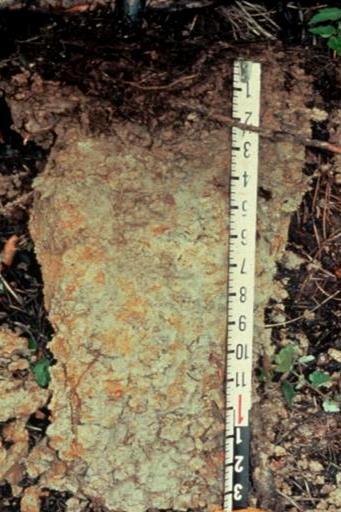
6 Long Duration Saturation Grey-Stripped mineral grains Black & brown-organic matter
7 Landscapes & Landforms Landscape: a collection of spatially-related landforms. Landform: a naturally-occurring physical feature on the earth s surface with a characteristic shape. Example: a prairie landscape is a relatively flat & grass dominated area with hills, rivers, & depressions. Wetland landscape position: location of a wetland relative to other landforms

8 Landscapes vs. Landforms Photo by Ben Kimball, NHDFL

9 Divergent & Convergent Landscape Positions
10 Landscape Position-Slope Shape Divergent slopes (A) disperse surface water, whereas convergent slopes (B) concentrate surface water. Surface flow paths are indicated by arrows.
11 Landscape Position-Surface Shape Linear
12 Hillslope Position Effects Toeslope Erosional position: Soil material moves downslope or downstream Shallow soil, coarser texture, low o.m. Depositional position: Soil material moves in from another location Deep soil, finer texture, more o.m.
13 Wetland Landscapes Tidal marshes Peat bogs Mineral soil flats Riverine wetlands Slope wetlands Depressions


14 Wet Wetter Wettest A A O A horizons Organic coated mineral grains O horizons Organic


15 Histosols, Organic Soils High primary productivity Low decomposition rates Long-term saturation/inundation Low temperatures O O

16 Tidal Marshes Surface water-tidal Peraquic moisture regime: always saturated High primary productivity Erosional & depositional surfaces Hydrogen sulfide-rotten egg smell


17 Tidal Marsh Soils Soil forming processes: sedimentation & organic matter accretion Subsiding landscape-relative sea level rise 1. organic soils, 2. mineral soils, 3. soils with upland characteristics 1 2 3

18 Tidal Marsh Soils
 Submerged: benign Disturbed: FeS 2 + O 2 = sulfuric acid +")
19 Acid Sulfate Soils High levels of iron sulfide minerals (Pyrite, FeS 2 ) Submerged: benign Disturbed: FeS 2 + O 2 = sulfuric acid + iron


20 Organic Soil Flats-Northern Peat Bog Permanently saturated Low temperatures, acidic conditions Low decomposition rates-organic soils


21 Riverine Wetlands Overbank flow, groundwater discharge Transient flooding to long-term ponding Floodplains may be both erosional & depositional depending on the energy in the moving water. High energy: erosional-low o.m., sandy soils Low energy: depositional-loamy soils


22 Riverine Wetlands-Accretion Floodplains Overbank flooding Young soils: limited development


23 Floodplain-Stratified Layers Multiple thin horizons representing different parent materials. Large variability in textures Buried O & A horizons


24 Riverine Wetlands-Backswamps Groundwater discharge Infrequent overbank flooding Long-duration ponding Organic soils

.")
25 Backslope Wetlands Discharge systems release groundwater to the land surface (seeps, springs). Erosional surface: shallow soils


26 Toeslope Wetlands Depositional surface: deep soils Seasonal to near-permanent inundation Floodplain characteristics


27 Closed Depressions Subject to ponding: seasonal or long term Precipitation, surface flow, groundwater Depositional surface: loamy soils

28 Depressional Wetlands Center: seasonal ponding Umbric surface-thick, dark A Edge: transient ponding Thin A, redox concentrations


29 Mineral Soil Flats Seasonally saturated Seasonal or no inundation Dynamic water table O thin or absent Thin A Redox concentrations
30 Take Home Messages 1. Hydric soil morphology reflects ecosystem characteristics, especially landscape position & long-term hydrologic condition. 2. Landscape position & surface shape has a strong influence on hydrologic characteristics of each wetland.
31 Take Home Messages 3. Since each wetland class has characteristic hydrologic conditions, each wetland class has characteristic hydric soils. a. Long-term inundation &/or near-constant shallow saturation: organic soils (tidal marsh, peat bog) b. Seasonal inundation: well developed O ; thick, dark A (depressions) c. Seasonal saturation: O is thin or absent (mineral soil flats) d. Flowing surface water: stratified layers (floodplains, toeslopes)
32
HYDRIC SOILS. Background
 Background HYDRIC SOILS Soils consist of natural bodies that occur on a landform within a landscape and have properties that result from the integrated effects of climate and living organisms, acting on
Introduction to the Hydrogeomorphic (HGM) Classification System
 Classification System") Introduction to the Hydrogeomorphic (HGM) Classification System Objectives The Student Will be Able to: Define the 7 HGM Classes List the 3 Parameters That Define HGM Classes List the Major Water Budget
Introduction to the Hydrogeomorphic (HGM) Classification System Objectives The Student Will be Able to: Define the 7 HGM Classes List the 3 Parameters That Define HGM Classes List the Major Water Budget
Introduction to Soil Science and Wetlands Kids at Wilderness Camp
 Introduction to Soil Science and Wetlands Kids at Wilderness Camp Presented by: Mr. Brian Oram, PG, PASEO B.F. Environmental Consultants http://www.bfenvironmental.com and Keystone Clean Water Team http://www.pacleanwater.org
RALPH SIMMONS STATE FOREST 2016 LAND MANAGEMENT PLAN EXHIBITS
 RALPH SIMMONS STATE FOREST 2016 LAND MANAGEMENT PLAN EXHIBITS EXHIBIT A Location Map Exhibit A EXHIBIT B Management Accomplishment Summary for RSSF EXHIBIT C Proximity to Other Public Lands Exhibit C
Guidelines for Using the NTCHS Indicators of Hydric Soils. 1.NTCHS Indicators of Hydric Soils (p1)
") Guidelines for Using the NTCHS Indicators of Hydric Soils Outline: 1. Glossary of Terms and Guides Used with Soil Descriptions 2. Soil Plug Extraction Procedure 3. Caveats for Using the Indicators Ref:
Guidelines for Using the NTCHS Indicators of Hydric Soils Outline: 1. Glossary of Terms and Guides Used with Soil Descriptions 2. Soil Plug Extraction Procedure 3. Caveats for Using the Indicators Ref:
Ground Water Control of Tree Island Origin, Genesis and Destruction. By John F. Meeder and Peter W. Harlem SERC,FIU
 Ground Water Control of Tree Island Origin, Genesis and Destruction By John F. Meeder and Peter W. Harlem SERC,FIU Functional Definition Our functional definition of a Tree Island is; an isolated scrub
Soil Formation. Lesson Plan: NRES B2-4
 Soil Formation Lesson Plan: NRES B2-4 1 Anticipated Problems 1. What are five different factors that affect soil formation? 2. What are some different types of parent material that affect soils? 3. What
MEMORANDUM FOR SWG
 MEMORANDUM FOR SWG-2007-1623 Subject: Jurisdictional Determination (JD) for SWG-2007-1623 on Interdunal Wetlands Adjacent to Traditional Navigable Waters (TNWs) Summary The U.S. Environmental Protection
Geology and New England Landscapes
 Geology and New England Landscapes Jim Turenne, CPSS USDA-NRCS Warwick, RI. http://nesoil.com Why Geology? Provides the big picture of site conditions. Major part of soil formation (parent material and
Unit E: Basic Principles of Soil Science. Lesson 2: Understanding Soil Formation
 Unit E: Basic Principles of Soil Science Lesson 2: Understanding Soil Formation Important Terms Alluvium Bedrock Chemical weathering Climate Glacial till Loess Native vegetation Organic matter Outwash
Permafrost-influenced Geomorphic Processes
 Section 4 Permafrost-influenced Geomorphic Processes Geomorphic processes vary greatly among ecoregions in northern Alaska, extending from the Beaufort Sea coast to the Brooks Range (Figure 4.1). Regional
Lecture 7: Introduction to Soil Formation and Classification
 Lecture 7: Introduction to Soil Formation and Classification Soil Texture and Color Analysis Lab Results Soil A: Topsoil from Prof. Catalano s backyard Soil B: Soil above beach at Castlewood State Park
Classification according to patent rock material/origin, soil distribution and orders
 Classification according to patent rock material/origin, soil distribution and orders Alluvial Soils Shales and Sandstone Soils Limestone Soils Chocolate Hills: Limestone formation Andesite and Basalt
Jim Turenne. Soils on Social Media
 Jim Turenne USDA-NRCS 60 Quaker Lane, Suite 46 Warwick, RI. 02886 401-822-8832 Jim.turenne@ri.usda.gov Soils on Social Media www.twitter.com/soilsne www.fb.com/soilsne www.nesoil.com U.S. Department of
Chapter 2. Regional Landscapes and the Hydrologic Cycle
 Chapter 2. Regional Landscapes and the Hydrologic Cycle W. Lee Daniels Department of Crop and Soil Environmental Sciences, Virginia Tech Table of Contents Introduction... 23 Soils and landscapes of the
APPENDIX G GLOSSARY. Mn/DOT/WR-0200
 APPENDIX G GLOSSARY Mn/DOT/WR-0200 Alluvial - comprised of clay, silt, sand, gravel, and/or other detritus deposited by water. Usually refers to accretionary overbank, floodplain or levee deposits. Biomantling
Properties and Characterization of Subaqueous Soils
 Properties and Characterization of Subaqueous Soils Martin C. Rabenhorst Environmental Science and Technology University of Maryland Mark H. Stolt Natural Resources Science University of Rhode Island What
Soils of Rhode Island
 Soils of Rhode Island Jim Turenne, RI State Soil Scientist USDA-NRCS 60 Quaker Ln. Suite 46 Warwick, RI. 02886 401-822-8830 http://nesoil.com Jim.turenne@ri.usda.gov About NRCS Established as the Soil
Background information of groundwater dependent ecosystems (GDE) on Estonian Gauja-Koiva river basin
 on Estonian Gauja-Koiva river basin") Background information of groundwater dependent ecosystems (GDE) on Estonian Gauja-Koiva river basin Elve Lode & Martin Küttim Content Some facts about the Koiva river Something about GDEs Ecological data
Background information of groundwater dependent ecosystems (GDE) on Estonian Gauja-Koiva river basin Elve Lode & Martin Küttim Content Some facts about the Koiva river Something about GDEs Ecological data
Weathering, Erosion & Soils Quiz
 Weathering, Erosion & Soils Quiz Multiple Choice Identify the choice that best completes the statement or answers the question. 1. The diagram below shows a cross-section of a rock layer. Erosion is the
±10.89 AC. Lincreek Drive Columbia, South Carolina. Site. Property Features. For Sale. Tom Milliken
 For Sale ±10.89 AC Site ive Columbia, South Carolina Tombo Milliken +1 803 744 9852 tombo.milliken@naiavant.com Tom Milliken +1 803 744 9837 tmilliken@naiavant.com Property Features ±10.89 AC on ive near
 12 10 8 6 4 2 0 40-50 50-60 60-70 70-80 80-90 90-100 Fresh Water What we will cover The Hydrologic Cycle River systems Floods Groundwater Caves and Karst Topography Hot springs Distribution of water in
Ecoregions Glossary. 7.8B: Changes To Texas Land Earth and Space
 Ecoregions Glossary Ecoregions The term ecoregions was developed by combining the terms ecology and region. Ecology is the study of the interrelationship of organisms and their environments. The term,
Soil Map Polk County, Florida
 Soil Map Polk County, Florida 28 9' 21'' 28 8' 23'' 3113000 3113200 3113400 3113600 3113800 3114000 3114200 3114400 3114600 81 51' 19'' 81 51' 19'' 416000 416000 ± 416200 416200 68 416400 68 416400 7 13
Custom Soil Resource Report for Forrest County, Mississippi
 United States Department of Agriculture Natural Resources Conservation Service A product of the National Cooperative Soil Survey, a joint effort of the United States Department of Agriculture and other
Standards and Procedures for Site Specific Soil Mapping in Rhode Island. Pg 1
 Standards and Procedures for Site Specific Soil Mapping in Rhode Island Pg 1 The Task Take This and Create This The Task Take This and Create This and a Report Pg 2 How is this different than the RI Soil
Lecture 29: Soil Formation
 Lecture 29: Soil Formation Factors Controlling Soil Formation 1. Parent material: Soil precursor 2. Climate: Temperature and precipitation 3. Biota: Native vegetation, microbes, soil animals, humans 4.
River floodplain regime and stratigraphy. Drs. Nanette C. Kingma.
 River floodplain regime and stratigraphy. Drs. Nanette C. Kingma. Formation of floodplain. Formation of floodplains: lateral channel migration in channel deposition suspended-load fall out during higher
Factors influencing nutrient and sediment retention by riverine wetlands in the Chesapeake watershed Greg Noe, Cliff Hupp, Ed Schenk, Nancy Rybicki
 Factors influencing nutrient and sediment retention by riverine wetlands in the Chesapeake watershed Greg Noe, Cliff Hupp, Ed Schenk, Nancy Rybicki National Research Program, Reston VA U.S. Department
Environmental Science
 Environmental Science A Study of Interrelationships Cui Jiansheng Hebei University of Science and Technology CH06 Kinds of Ecosystems and Communities Chapter Objectives After reading this chapter, you
2017 NACTA Contest FAQs for 2-Year and 4-Year Universities
 2017 NACTA Contest FAQs for 2-Year and 4-Year Universities 1. Have you determined how many practice days there will be? a. We plan on having 10 practice sites. They will be open on Tuesday, Wednesday,
9 th INTECOL Orlando, Florida June 7, 2012
 Restoration of the Everglades Saline Wetlands and Florida Bay: Responses Driven from Land and Sea David Rudnick 1, Colin Saunders 2, Carlos Coronado 2, Fred Sklar 2 Erik Stabenau 1, Vic Engel 1, Rene Price
Acid sulfate soils in Finland Anton Boman
 Acid sulfate soils in Finland Anton Boman Senior Scientist, Environmental geology, GTK Definition of acid sulfate soils (ASS) ASS are defined as any soil, sediment, till or peat that contain sulfidic material
A Help Guide for Using gssurgo to Find Potential Wetland Soil Landscapes
 A Help Guide for Using gssurgo to Find Potential Wetland Soil Landscapes Wetland Mapping Consortium Webinar September 17, 2014 Dr. John M. Galbraith Crop & Soil Environmental Sciences Virginia Tech Wetland
Cook Road Ridgeway, South Carolina
 For Sale or Ground Lease ±66.0 AC Industrial Land k Rd Coo Cook Road Ridgeway, South Carolina THE INFORMATION CONTAINED HEREIN HAS BEEN GIVEN TO US BY THE OWNER OF THE PROPERTY OR OTHER SOURCES WE DEEM
Simulating the groundwater discharge to wetlands. Mukwonago Basin Example and Potential Application in Dane County
 Simulating the groundwater discharge to wetlands Mukwonago Basin Example and Potential Application in Dane County Conceptual Model Topography is major control on flow to wetlands Land Surface Water Table
Diagnostic materials
 Diagnostic materials It appeared appropriate to define diagnostic soil materials. These diagnostic soil materials are intended to reflect the original parent materials, in which pedogenetic processes have
Name Date Class. biota climate decomposition horizon organic matter parent material pore sediment soil topography. Clues
 Content Vocabulary Directions: Use the clues and the terms listed below to complete the puzzle. NOTE: There is no empty square in the puzzle between the words of two-word terms. Some words may not be used.
Surface Processes Focus on Mass Wasting (Chapter 10)
") Surface Processes Focus on Mass Wasting (Chapter 10) 1. What is the distinction between weathering, mass wasting, and erosion? 2. What is the controlling force in mass wasting? What force provides resistance?
Surface Processes Focus on Mass Wasting (Chapter 10) 1. What is the distinction between weathering, mass wasting, and erosion? 2. What is the controlling force in mass wasting? What force provides resistance?
Each basin is surrounded & defined by a drainage divide (high point from which water flows away) Channel initiation
 Channel initiation") DRAINAGE BASINS A drainage basin or watershed is defined from a downstream point, working upstream, to include all of the hillslope & channel areas which drain to that point Each basin is surrounded &
DRAINAGE BASINS A drainage basin or watershed is defined from a downstream point, working upstream, to include all of the hillslope & channel areas which drain to that point Each basin is surrounded &
Developing a Landscape-Level Reference Standard Wetland Profile for the Prairie Pothole Region, Montana
 Developing a Landscape-Level Reference Standard Wetland Profile for the Prairie Pothole Region, Montana Prepared for: The U.S. Environmental Protection Agency Prepared by: Melissa Hart and Linda Vance
Ms. A. Mormando's Class *
 8 th Grade Science Essential Standard: 8.E.1.1 Explain the structure of the hydrosphere including: Water distribution on Earth; Local river basin and water availability Stream - A stream is a body of water
Subtidal permanently flooded with tidal water. Irregularly exposed surface exposed by tides less often than daily
 Types of Wetlands Tidal Systems COASTAL WETLAND ECOSYSTEMS Tidal Salt Marshes Tidal Freshwater Marshes Mangrove Wetlands Tidal Estuarine Wetland 1 Definition and Formation of Estuaries u Estuary : partially
Types of Wetlands. Tidal Systems
 Types of Wetlands Tidal Systems 1 COASTAL WETLAND ECOSYSTEMS Tidal Salt Marshes Tidal Freshwater Marshes Mangrove Wetlands 2 Tidal Estuarine Wetland 3 Definition and Formation of Estuaries Estuary: : partially
Field Handbook for the Soils of Western Canada. Section 2. Site and Sampling Point Description. November Dan Pennock University of Saskatchewan
 Field Handbook for the Soils of Western Canada Section 2 Site and Sampling Point Description November 2015 Dan Pennock University of Saskatchewan This is one section of a Field Handbook for the Soils of
Laboratory Exercise #3 The Hydrologic Cycle and Running Water Processes
 Laboratory Exercise #3 The Hydrologic Cycle and Running Water Processes page - 1 Section A - The Hydrologic Cycle Figure 1 illustrates the hydrologic cycle which quantifies how water is cycled throughout
Nitrogen and phosphorus dynamics in restored riverine floodplains in intensively managed watersheds
 Nitrogen and phosphorus dynamics in restored riverine floodplains in intensively managed watersheds Sara McMillan 1, Alex Johnson 1, Celena Alford 1, Greg Noe 2, Venkatesh Merwade 1, Sayan Dey, 1 Siddharth
Appendix E: Cowardin Classification Coding System
 Appendix E: Cowardin Classification Coding System The following summarizes the Cowardin classification coding system and the letters and numbers used to define the USFWS NWI wetland types and subtypes:
Monday, Oct Field trip A1 & A2 signups: make sure you are where you think you should be
 Monday, Oct. 4 1. Field trip A1 & A2 signups: make sure you are where you think you should be 2. 5 credit people, field trip introduction in lab today 1. If you are unable to attend THIS SATURDAY, let
The physical breakdown and chemical alteration of rocks and minerals at or near Earth s surface.
 The physical breakdown and chemical alteration of rocks and minerals at or near Earth s surface. The material that is chemically and mechanically weathered to yield sediment and soil. Regolith consisting
Natural Shoreline Landscapes on Michigan Inland Lakes
 Natural Shoreline Landscapes on Michigan Inland Lakes Excerpts from Chapters 2 and 3 Photo Photo by Jane by Jane Herbert Herbert Did you know? Twenty-four species of amphibians, 25 species of reptiles,
Betsy Stevenson and Allison Mohrs (Skagit County Planning and Development Services) Jenny Baker, The Nature Conservancy
 Jenny Baker, The Nature Conservancy") TC Fisher Slough Final Design and Permitting Subject: Well Review Memorandum To: From: Betsy Stevenson and Allison Mohrs (Skagit County Planning and Development Services) Jenny Baker, The ature Conservancy
TC Fisher Slough Final Design and Permitting Subject: Well Review Memorandum To: From: Betsy Stevenson and Allison Mohrs (Skagit County Planning and Development Services) Jenny Baker, The ature Conservancy
Subaqueous Soils A A New Frontier in Soil Survey. By Jim Turenne
 Subaqueous Soils A A New Frontier in Soil Survey By Jim Turenne http://nesoil.com.sas Subaqueous History Traditional soil survey conducted on land. Not a lot of work in wetlands and tidal marshes until
Custom Soil Resource Report Soil Map
 77 35' 22'' W Custom Soil Resource Report Soil Map 77 35' 0'' W 282170 282220 282270 282320 282370 282420 282470 282520 282570 282620 40 59' 2'' N 40 58' 52'' N 4539900 4539950 4540000 4540050 4540100
Fairfield Hill Road Winnsboro, South Carolina
 Fairfield Hill Road Winnsboro, South Carolina Tom Milliken +1 803 331 6999 tmilliken@naiavant.com Tombo Milliken +1 803 206 8384 tombo.milliken@naiavant.com THE INFORMATION CONTAINED HEREIN HAS BEEN GIVEN
Riparian Assessment. Steps in the right direction... Drainage Basin/Watershed: Start by Thinking Big. Riparian Assessment vs.
 Riparian Assessment vs. Monitoring Riparian Assessment What is a healthy stream? Determine stream/riparian health Determine change or trend, especially in response to mgmt Classification = designation
Hydric Rating by Map Unit Harrison County, Mississippi 30 27' 27'' 30 26' 57''
 Hydric Rating by Map Unit Harrison County, Mississippi 30 27' 27'' 30 26' 57'' 3370400 3370500 3370600 3370700 3370800 3370900 3371000 3371100 3371200 89 2' 40'' 89 2' 41'' 303700 303700 303800 303800
Lab 7: Sedimentary Structures
 Name: Lab 7: Sedimentary Structures Sedimentary rocks account for a negligibly small fraction of Earth s mass, yet they are commonly encountered because the processes that form them are ubiquitous in the
Chemical Weathering and Soils
 Chemical Weathering and Soils Fresh rocks and minerals that once occupied the outermost position reached their present condition of decay through a complex of interacting physical, chemical, and biological
The River Restoration Centre therrc.co.uk. Understanding Fluvial Processes: supporting River Restoration. Dr Jenny Mant
 The River Restoration Centre therrc.co.uk Understanding Fluvial Processes: supporting River Restoration Dr Jenny Mant Jenny@therrc.co.uk Understanding your catchment Hydrology Energy associated with the
±3.18 AC. 512 Rebecca Drive Leesville, South Carolina. Lakefront Lot. Property Features. For more information:
 For Sale ±3.18 AC Lakefront Lot *Lake level down 6 at time photo was taken 512 ive Leesville, South Carolina Property Features ±3.18 acre lot for sale on Lake Murray Bank owned Located on the Lexington
University of Pretoria. Matthys Dippenaar and Louis van Rooy Engineering Geology and Hydrogeology, Geology Department July 2017, Livingstone, Zambia
 University of Pretoria Contributions to the Characterisation of the Vadose Zone f or Hydrogeological and Geotechnical Applications Matthys Dippenaar and Louis van Rooy Engineering Geology and Hydrogeology,
Upper Truckee River Restoration Lake Tahoe, California Presented by Brendan Belby Sacramento, California
 Upper Truckee River Restoration Lake Tahoe, California Presented by Brendan Belby Sacramento, California Mike Rudd (Project Manager), Charley Miller & Chad Krofta Declines in Tahoe s Water Clarity The
ES 105 Surface Processes I. Hydrologic cycle A. Distribution % in oceans 2. >3% surface water a. +99% surface water in glaciers b.
 ES 105 Surface Processes I. Hydrologic cycle A. Distribution 1. +97% in oceans 2. >3% surface water a. +99% surface water in glaciers b. >1/3% liquid, fresh water in streams and lakes~1/10,000 of water
STUDY GUIDE FOR CONTENT MASTERY. Surface Water Movement
 Surface Water SECTION 9.1 Surface Water Movement In your textbook, read about surface water and the way in which it moves sediment. Complete each statement. 1. An excessive amount of water flowing downslope
3.3 CLIMATE, GEOLOGY, TOPOGRAPHY, AND SOILS CLIMATE GEOLOGY TOPOGRAPHY
 3.3 CLIMATE, GEOLOGY, TOPOGRAPHY, AND SOILS This section describes the climate, geology, topography, and soil resource characteristics of the Yolo Bypass Wildlife Area (Wildlife Area). Agricultural soil
Maggie Payne Jim Turenne
 Maggie Payne Jim Turenne USDA-NRCS 60 Quaker Lane, Suite 46 Warwick, RI. 02886 401-822-8832 maggie.payne@ri.usda.gov U.S. Department of Agriculture 1935: Soil Conservation Service (SCS) Natural Resources
ADDRESSING GEOMORPHIC AND HYDRAULIC CONTROLS IN OFF-CHANNEL HABITAT DESIGN
 ADDRESSING GEOMORPHIC AND HYDRAULIC CONTROLS IN OFF-CHANNEL HABITAT DESIGN Conor Shea - Hydrologist U.S. Fish and Wildlife Service Conservation Partnerships Program Arcata, CA Learning Objectives Examine
Wetland Definition Diagram
 Wetland Organisms 1 Wetland Definition Diagram 2 Stress Experienced In Wetlands Anoxia Salt Concentrations Water Fluctuation 3 Anoxic Conditions Soils saturated/inundated Anaerobic Conditions May vary
Which map shows the stream drainage pattern that most likely formed on the surface of this volcano? A) B)
 B)") 1. When snow cover on the land melts, the water will most likely become surface runoff if the land surface is A) frozen B) porous C) grass covered D) unconsolidated gravel Base your answers to questions
1. When snow cover on the land melts, the water will most likely become surface runoff if the land surface is A) frozen B) porous C) grass covered D) unconsolidated gravel Base your answers to questions
Temperature and Precipitation. Next stage will depend on climate and parent materials
 Next stage will depend on climate and parent materials Rainfall and temperature will determine nature of vegetation Resistance of parent material to weathering will determine rate and type of clay formation,
Wetland & Floodplain Functional Assessments and Mapping To Protect and Restore Riverine Systems in Vermont. Mike Kline and Laura Lapierre Vermont DEC
 Wetland & Floodplain Functional Assessments and Mapping To Protect and Restore Riverine Systems in Vermont Mike Kline and Laura Lapierre Vermont DEC NWI+ Hydro-Geomorphic Characterization of Wetlands and
Nutrient and Sediment Cycling and Retention in Urban Floodplain Wetlands
 Nutrient and Sediment Cycling and Retention in Urban Floodplain Wetlands Greg Noe, Cliff Hupp, Nancy Rybicki, Ed Schenk, and Jackie Batson National Research Program, Reston VA U.S. Department of the Interior
Hydric Rating by Map Unit Harrison County, Mississippi. Web Soil Survey National Cooperative Soil Survey
 89 9' 7'' W 89 8' 38'' W 30 34' 13'' N 30 33' 57'' N 3383480 3383560 3383640 3383720 3383800 3383880 3383960 293640 293720 293800 293880 293960 294040 294120 294200 294280 294360 3383480 3383560 3383640
Removal of riverbank protection along the River Rhine (the Netherlands)
") RR 2004 3rd European Conference on River Restoration RIVER RESTORATION 2004 Zagreb, Croatia, 17-21 May 2004 Removal of riverbank protection along the River Rhine (the Netherlands) L.J. Bolwidt, H.E.J.
RR 2004 3rd European Conference on River Restoration RIVER RESTORATION 2004 Zagreb, Croatia, 17-21 May 2004 Removal of riverbank protection along the River Rhine (the Netherlands) L.J. Bolwidt, H.E.J.
Wessinger Road, Hilton Area Chapin, South Carolina
 779' For Sale 191' 182' 171'! A! B 858' 4.84 ± Acres 788' 4.25 ± Acres 60' 241' 321' Wessinger Road, Hilton Area Chapin, South Carolina 357' 115' 51' 294'! C! D 6.51 ± Acres 902' 8.35 ± Acres 246' 60'
On-Site Soils Investigation. Buttermilk Way Storm water Treatment Project Buzzards Bay. MA. February 28 th, 2012
 1 On-Site Soils Investigation Buttermilk Way Storm water Treatment Project Buzzards Bay. MA February 28 th, 2012 Glenn Stanisewski, Resource Soil Scientist, USDA-NRCS, West Wareham, MA Introduction: The
Class Schedule and Assignments
 Class Schedule and Assignments Course Title: Soil Morphology and Mapping (PLNTSOIL 597T) Instructor: Time: Peter Fletcher (www.pfdigsoil@gmail.com) Home phone: (774) 202-5695 Cell phone: (508) 524-1397
CHAPTER 6 & 7 VOCABULARY
 CHAPTER 6 & 7 VOCABULARY 1. Biome 2. Climate 3. Latitude 4. Altitude 5. Emergent layer 6. Epiphyte 7. Understory 8. Permafrost 9. Wetland 10.Plankton 11.Nekton 12.Benthos 13.Littoral zone 14.Benthic zone
DETERMINING SOIL PATTERNS IN SINGLETON TRAINING AREA NOT IDENTIFIED BY GEOLOGY AND CATENARY POSITION
 DETERMINING SOIL PATTERNS IN SINGLETON TRAINING AREA NOT IDENTIFIED BY GEOLOGY AND CATENARY POSITION Robert Gourlay and Brian Tunstall 1994 ABSTRACT A prior soil survey of the Singleton Training Area identified
Earth: The Water Planet
 Earth: The Water Planet Water is essential for living things to grow, reproduce, and carry out important processes. About 97% of Earth s water is salt water found in the ocean, while the other 3% is fresh
±35.80 AC. E/S Old Brickyard Road Irmo, South Carolina. Site. Gerald Steele Property Features.
 Site For Sale ±35.80 AC Dutch Fork Middle School Dutch Fork High School E/S Old Brickyard Road Irmo, South Carolina Gerald Steele +1 803 744 9851 gsteele@naiavant.com Property Features ±35.80 Acres for
DISTRIBUTION OF METALS IN PARTICLE SIZE FRACTIONS IN SOILS OF TWO FORESTED CATENAS (SMOLENSK MOSCOW UPLAND)
") 28 GEOGRAPHY Olga A. Samonova 1, Elena N. Aseyeva 2 * 1 Faculty of Geography, Moscow State University, Moscow, 119991, Russia; e-mail: оsamonova@mail.ru 2 Faculty of Geography, Moscow State University,
28 GEOGRAPHY Olga A. Samonova 1, Elena N. Aseyeva 2 * 1 Faculty of Geography, Moscow State University, Moscow, 119991, Russia; e-mail: оsamonova@mail.ru 2 Faculty of Geography, Moscow State University,
Beaver Dam Influence on Wet Meadow Habitat
 Beaver Dam Influence on Wet Meadow Habitat HOPE FISHER WRITER S COMMENT: I ve always been fascinated by the natural world. This deep appreciation for nature and passion for conservation inspired me to
6.1 Water. The Water Cycle
 6.1 Water The Water Cycle Water constantly moves among the oceans, the atmosphere, the solid Earth, and the biosphere. This unending circulation of Earth s water supply is the water cycle. The Water Cycle
Aquifer an underground zone or layer of sand, gravel, or porous rock that is saturated with water.
 Aggradation raising of the streambed by deposition that occurs when the energy of the water flowing through a stream reach is insufficient to transport sediment conveyed from upstream. Alluvium a general
Prentice Hall EARTH SCIENCE
 Prentice Hall EARTH SCIENCE Tarbuck Lutgens Running Water and Groundwater Running Water The Water Cycle Water constantly moves among the oceans, the atmosphere, the solid Earth, and the biosphere. This
Changes in Texas Ecoregions Copy the questions and answers
 Changes in Texas Ecoregions Copy the questions and answers 1. What are some kinds of damage that hurricanes cause? Roads and bridges might be washed away. Trees and power lines can be knocked down. Area
How Do Human Impacts and Geomorphological Responses Vary with Spatial Scale in the Streams and Rivers of the Illinois Basin?
 How Do Human Impacts and Geomorphological Responses Vary with Spatial Scale in the Streams and Rivers of the Illinois Basin? Bruce Rhoads Department of Geography University of Illinois at Urbana-Champaign
The combination of factors required for the accumulation of sulphides occurs in three distinct environments (Pons and van Breemen 1982):
:") 6 Soil patterns 6.1 Potential acid sulphate environments Soil variation is always a problem for land-use planning and management. Acid sulphate soils are notoriously localised. Even within a single area
6 Soil patterns 6.1 Potential acid sulphate environments Soil variation is always a problem for land-use planning and management. Acid sulphate soils are notoriously localised. Even within a single area
Subaqueous Landforms, Features, and Materials ( much content from Jim Turenne, NRCS, & Mark Stolt, URI )
") Subaqueous Landforms, Features, and Materials ( much content from Jim Turenne, NRCS, & Mark Stolt, URI ) 1) Discrete underwater features or geoforms (that commonly can support rooted plants), and adjacent
Subaqueous Landforms, Features, and Materials ( much content from Jim Turenne, NRCS, & Mark Stolt, URI ) 1) Discrete underwater features or geoforms (that commonly can support rooted plants), and adjacent
Surface Water Short Study Guide
 Name: Class: Date: Surface Water Short Study Guide Multiple Choice Identify the letter of the choice that best completes the statement or answers the question. 1. The three ways in which a stream carries
AQUATIC RESOURCES DELINEATION REFRESHER
 AQUATIC RESOURCES DELINEATION REFRESHER James Jamie Robb Wetland Specialist, Office of the Chief 12 October 2016 US Army Corps of Engineers Ordinary High Water Mark (OHWM) How is the OHWM characterized
Soil Surveys. What are the most important properties to consider in a taxonomic system used for making a soil survey?
 Soil Surveys What are the most important properties to consider in a taxonomic system used for making a soil survey? What is a Soil Survey? Inventory of soil resources Delineation of spatial distribution
Wisconsin s Hydrogeology: an overview
 2012 Soil and Water Conservation Society Conference Stevens Point, WI Feb 9, 2012 Wisconsin s Hydrogeology: an overview Ken Bradbury Wisconsin Geological and Natural History Survey University of Wisconsin-Extension
Running Water Earth - Chapter 16 Stan Hatfield Southwestern Illinois College
 Running Water Earth - Chapter 16 Stan Hatfield Southwestern Illinois College Hydrologic Cycle The hydrologic cycle is a summary of the circulation of Earth s water supply. Processes involved in the hydrologic
STREAM SYSTEMS and FLOODS
 STREAM SYSTEMS and FLOODS The Hydrologic Cycle Precipitation Evaporation Infiltration Runoff Transpiration Earth s Water and the Hydrologic Cycle The Hydrologic Cycle The Hydrologic Cycle Oceans not filling
Precipitation Evaporation Infiltration Earth s Water and the Hydrologic Cycle. Runoff Transpiration
 STREAM SYSTEMS and FLOODS The Hydrologic Cycle Precipitation Evaporation Infiltration Earth s Water and the Hydrologic Cycle Runoff Transpiration The Hydrologic Cycle The Hydrologic Cycle Oceans not filling
Custom Soil Resource Report Soil Map
 121 3' 56'' W Custom Soil Resource Report Soil Map 121 2' 49'' W 45 16' 39'' N 5013800 5014000 5014200 5014400 5014600 5014800 5015000 5015200 5015400 5015600 651800 652000 652200 652400 652600 652800
Hydric Rating by Map Unit Harrison County, Mississippi
 89 6' 12'' W 89 5' 54'' W 30 28' 47'' N 30 28' 26'' N 3373210 3373290 3373370 3373450 3373530 3373610 3373690 3373770 3373850 298080 298160 298240 298320 298400 298480 298560 30 28' 47'' N Soil Map may