Some Thoughts on the Role of Elevation
|
|
|
- Lucinda Nichols
- 5 years ago
- Views:
Transcription
1 Some Thoughts on the Role of Elevation Data in Sea-level Rise Impact Assessments Rob Thieler* U.S. Geological Survey Coastal and Marine Geology Program Woods Hole, MA *i l d t i l d f D C h D G h *includes material drawn from Don Cahoon, Dean Gesch, and John Masterson.


2 We need better science* to prepare our local responses to climate change, especially in our coastal areas. (David Carter, Delaware Coastal Management) *science = better understanding of processes + better situation awareness


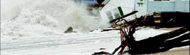
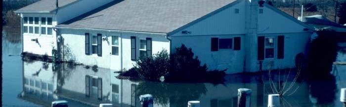
3 Coastal Flooding in Charleston, SC (Built environment impacts) NOAA NWS Charleston issues shallow coastal flooding advisories for 7 ft tides 7 ft tides typically predicted to occur twice a year With 1.6 ft of relative sealevel rise, this advisory could be issued 355 times (NOAA CSC)
4 Sea-level rise rates since the Last Glacial Maximum mwp-ia mwp-ib Global delta initiation (Stanley and Warne, 1994) U.S. Atlantic, U.K. wetland initiation; barrier island stability (Shennan and Horton, 2002; Engelhart et al., in press) Rate of SLR (mm m/yr) Thousands of 14 C years before present (SLR rate based on Fairbanks, 1989)
5 Past and Projected Sea-level Rise There are now several projections that suggest ~ cm rise is possible over the next century IPCC AR4 A1B envelope (modified after Rahmstorf, 2007; AR4 data from Bindoff, 2007)
6 Issue: Potential future rates of SLR far exceed recent experience 20 th Century eustatic rate was 1.7 mm/yr IPCC (2007) rates for the decade A1FI : mm/yr A1B : mm/yr There are only a few places in the world currently experiencing >5 mm/yr Geologic past (Fairbanks, 1989; Horton et al. 2009) Projections (Rahmstorf, 2007) Instrumental record (Church and White, 2006) Rate of SLR (mm/yr) Years before present
7 Coastal Vulnerability to Sea-level Rise: A Preliminary National Assessment (Thieler and Hammar-Klose 1999, 2000a, 2000b) Vulnerability Ranking


8 Coastal Vulnerability Studies in the National Parks Study sites in the Contiguous U.S. Study sites in Hawaii, Alaska, and U.S. Territories Cape Cod NS Cumberland Island NS Golden Gate NRA Fire Island NS Assateague Island NS Point Reyes NS Gateway NRA Dry Tortugas NP Olympic NP Gulf Islands NS Padre Island NS Apostle Islands NL Cape Hatteras NS Channel Islands NP Indiana Dunes NL Sleeping Bear Dunes NL Kenai Fjord NP Glacier Bay NPP Kaloko-Honokohau NHP NP of American Samoa Virgin Islands NP War in the Pacific NHP


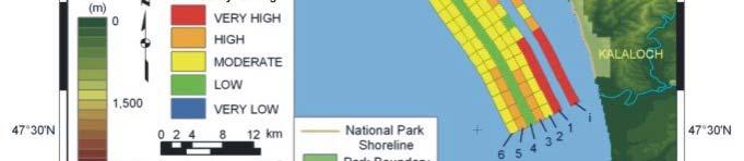
9 Cape Alava Assessments help managers plan for hazards Sand Point Norwegian Memorial


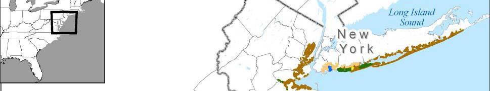
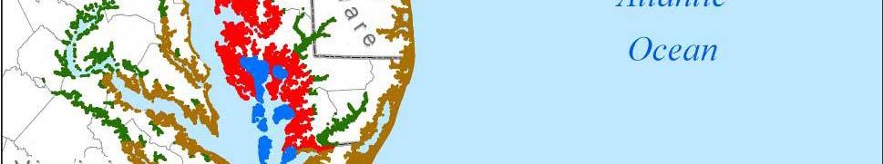
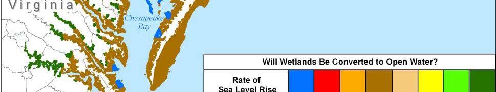
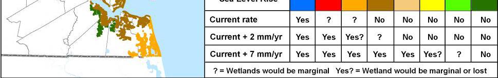
10 Coastal Sensitivity to Sea-Level Rise: A Focus on the Mid-Atlantic Region U.S. Climate Change Science Program Synthesis and Assessment Product 4.1

 Current elevation")


 would be valuable (Gesch")
11 Coastal Elevations Elevation is a critical factor in assessing potential impacts (specifically, inundation) Current elevation data do not provide the degree of confidence needed for quantitative assessments for local decision making Collection of high-quality elevation data (lidar) would be valuable (Gesch et al., 2009)


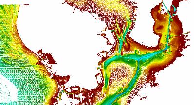
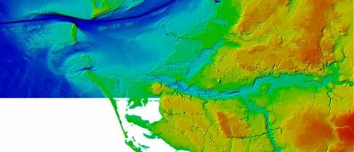
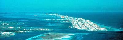
12 Eastern North Carolina Kilometers Elevation source: 30-m DEM Elevation source: 3-m lidar data Dark blue Land 1 meter elevation Light blue Area of uncertainty associated with 1 meter elevation High quality elevation data reduce uncertainty of potentially inundated areas (Gesch et al., 2009)


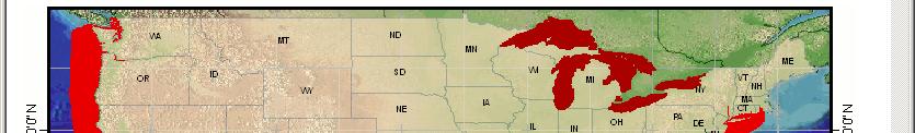
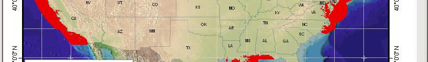
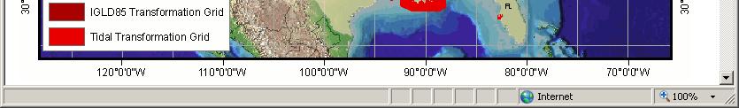
13 Geoid Tide Ellipsoid model model model USGS topography NOAA bathymetry Integrated topo/bathy elevation model

14
15 Coastal Elevations - Key Findings Elevation is a critical factor in assessing potential socioeconomic and environmental impacts in areas that are vulnerable to inundation It is important to understand the accuracy of the elevation data used in sea-level el rise assessments and its effects on the uncertainty of any resulting vulnerability maps and statistics Most current elevation data do not provide the degree of confidence needed for quantitative assessments for local decision making Collection of high-quality elevation data (lidar) will narrow the range of elevation uncertainty and improve the ability to conduct detailed assessments SAP 4.1 Coastal Sensitivity to Sea-level Rise
16 CCSP SAP 4.1 Coastal Elevations Future SLR vulnerability assessments: Determine where inundation will be the primary response to sea-level rise Use lidar elevation data (or other high-resolution, high-accuracy elevation source) Test and report absolute vertical accuracy as a measure of elevation uncertainty Apply elevation uncertainty t information in development of vulnerability maps and area statistics Produce spatially explicit maps and detailed statistics that can be used in local decision making
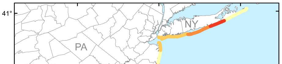
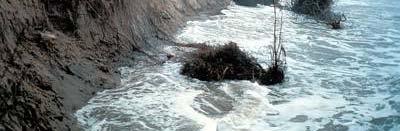
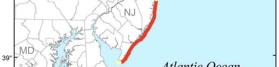
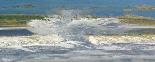
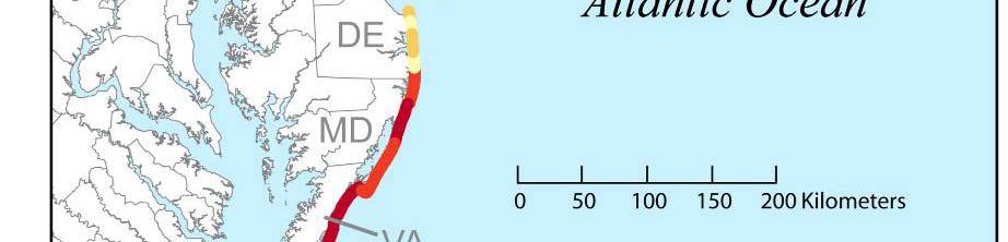

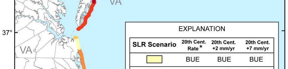
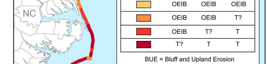
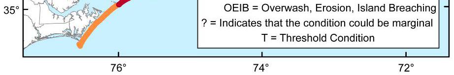

17 Mid-Atlantic Assessment of Potential Dynamic Coastal Responses to Sea-level Rise Bluff erosion Overwash Island Breaching (Gutierrez et al., 2009) Threshold Crossing


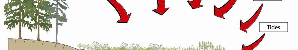

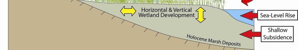
18 Coastal Wetlands Respond Dynamically to Environmental Change R. Carlson Wetland Vertical Development Mineral sediment deposition Plant matter accumulation - soil (root production/decomposition) Compaction Shrink-Swell D. Cahoon (Cahoon et al., 2009) D. Cahoon


19 Mid-Atlantic Wetlands Assessment (Cahoon et al., 2009)


20 Assessing wetland vulnerability to sea-level rise: STEP #1: Determine the elevation of your marsh relative to local sea level. Is your marsh located high s you a s ocated g or low within its optimum growth range?
 to tidal datums: a")
21 Elevation Capital McKee, K. L. & W. H. Patrick, Jr The relationship of smooth cordgrass (Spartina alterniflora) to tidal datums: a review. Estuaries 11:
22 Elevation Deficit Relative to Sea-Level Rise Marsh elevation gradually gets lower within the growth range, which leads to increased hydroperiod (frequency, depth and duration of flooding). When marsh elevation reaches the bottom of the growth range, the vegetation becomes stressed. Eventually marsh elevation falls below optimum growth range, the plants die, and marsh habitat converts to intertidal mudflat or subtidal open water.
23 For Spartina alterniflora salt marsh, plant production increases as depth of flooding increases. Big Egg Marsh, Jamaica Bay, New York City, Aug 2007
24 Jamaica Bay, New York City, April 2002 Remnant marsh peat Severely degraded marsh Black Wall Marsh, Jamaica Bay, NY
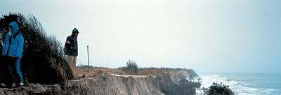
25 Assessing wetland vulnerability to sea-level rise: STEP #2: Determine the trend in elevation change of your marsh relative to local sea level. Is your marsh keeping pace with the local rate of sea-level rise or is it experiencing an elevation deficit?


26 Keeping Pace vs. Surviving Keeping Pace: no Surviving: no Keeping Pace: maybe? Surviving: yes, elevation capital Even though this marsh appears healthy, it could be experiencing an elevation deficit, and is surviving on its elevation capital


 Marker")
27 SET-MH Method The surface elevation table marker horizon method provides high resolution measures of vertical accretion, elevation change, and shallow subsidence such that the separate influence of surface and subsurface processes on elevation can be determined Surface Elevation Table (SET) Marker Horizon Cahoon et al. 1995
28 Assessing wetland vulnerability to sea-level rise: STEP #3: Determine the factors controlling elevation change (i.e., vertical development) in your marsh. Which environmental drivers and surface and subsurface processes most control elevation change in your marsh? Improve your ability to manage your marsh to Improve your ability to manage your marsh to survive future climate change!
29 Environmental Drivers Influencing Vertical and Horizontal Wetland Development Wetland Vertical Development Mineral sediment deposition Plant matter accumulation - soil (root production/decomposition) Compaction Shrink-Swell Cahoon et al CCSP SAP 4.1
30 Assessing wetland vulnerability to sea-level rise: STEP #4: Estimate the ability of your marsh to build vertically under future sea-level rise and global change scenarios using models developed d with the information acquired in Steps 1-3. Improve your ability to manage your marsh to survive future climate change!
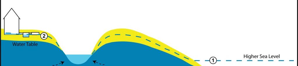
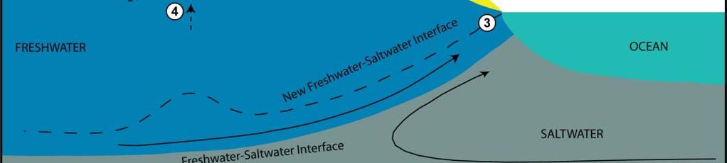
31 SLR Effects on Groundwater Flow
32 Change in Water-Table Elevation Subsurface flooding: Subterranean structures Septic systems Beach erosion Increased Surface-Water Discharge: Increased streamflow Expansion of riparian wetland areas Changes in hydraulic gradients Changes in delivery mechanism by which nutrients discharge to coast


33 Freshwater Flow Lens: Cape Cod, MA Source: Masterson and Garabedian (2007)


34 Freshwater Flow Lens: Cape Cod, MA Modified from McCobb and Weiskel (2003)
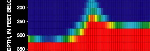
35 Depth to Water: Shoreline Erosion Coastal Stabilization, Inc., 1989

36

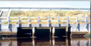
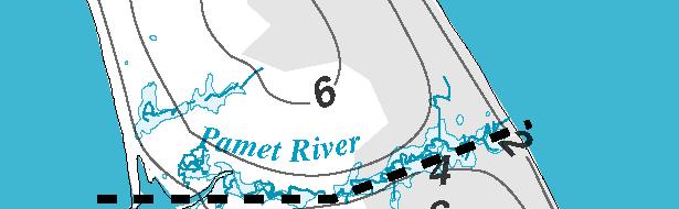
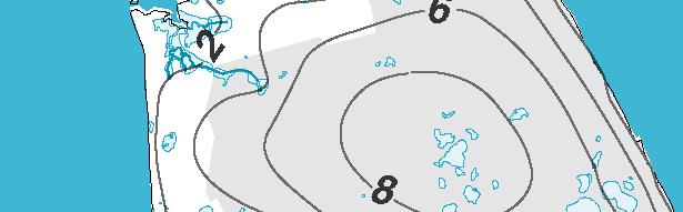
37 Tide Control Structure: CCNS Marsh restoration would improve: flushing rate, water quality, habitat diversity, and regain balance between local sea level and wetlands in upper Pamet basin Marsh restoration efforts hindered by local community concerns regarding water supply and flooding


38 South North N S
39 Summary There are good protocols for integrating survey and lidar data, and how to express bathtub-type inundation i model results Outstanding potential to address salt marsh and gp groundwater issues
Sea-level Rise on Cape Cod: How Vulnerable Are We? Rob Thieler U.S. Geological Survey Woods Hole, MA
 Sea-level Rise on Cape Cod: How Vulnerable Are We? Rob Thieler U.S. Geological Survey Woods Hole, MA Outline Sea-level and coastal processes Past sea-level change Predictions for the future Coastal responses
Sea-level Rise and Storm Effects on Coastal Systems under Changing Global Climate. Cape May, NJ 12 January 2009
 Sea-level Rise and Storm Effects on Coastal Systems under Changing Global Climate 2009 Delaware Estuary Science Summit Cape May, NJ 12 January 2009 S. Jeffress Williams Senior Coastal Marine Geologist
Tony Pratt, DNREC to The Center for the Inland Bays Scientific and Technical Advisory Committee. August 21, 2009
 Sea Level Rise in Delaware Presented by Tony Pratt, DNREC to The Center for the Inland Bays Scientific and Technical Advisory Committee August 21, 2009 Sea level has been fluctuating ever since there have
Mapping, monitoring, and modeling: USGS Coastal and Marine Geology activities along the Northeast coast
 Mapping, monitoring, and modeling: USGS Coastal and Marine Geology activities along the Northeast coast Coastal and Marine Geology Program Woods Hole Coastal and Marine Science Center St. Petersburg Coastal
Australian Coastal Councils Conference
 Australian Coastal Councils Conference 11 March 2015 Estimating Future Coastal Inundation and Erosion Hazards Dr Andrew McCowan Dr Christine Lauchlan-Arrowsmith Warwick Bishop Background Victorian Future
Subtidal permanently flooded with tidal water. Irregularly exposed surface exposed by tides less often than daily
 Types of Wetlands Tidal Systems COASTAL WETLAND ECOSYSTEMS Tidal Salt Marshes Tidal Freshwater Marshes Mangrove Wetlands Tidal Estuarine Wetland 1 Definition and Formation of Estuaries u Estuary : partially
Types of Wetlands. Tidal Systems
 Types of Wetlands Tidal Systems 1 COASTAL WETLAND ECOSYSTEMS Tidal Salt Marshes Tidal Freshwater Marshes Mangrove Wetlands 2 Tidal Estuarine Wetland 3 Definition and Formation of Estuaries Estuary: : partially
Sea-Level Rise for the Coasts of California, Oregon, and Washington: Past, Present, and Future
 Sea-Level Rise for the Coasts of California, Oregon, and Washington: Past, Present, and Future Robert A. Dalrymple Committee Chair and Johns Hopkins University June 20, 2012 Global sea level is rising
Mapping of Future Coastal Hazards. for Southern California. January 7th, David Revell, Ph.D. E.
 Mapping of Future Coastal Hazards for Southern California January 7th, 2014 David Revell, Ph.D. drevell@esassoc.com E. Vandebroek, 2012 Outline Coastal erosion hazard zones Flood hazard zones: Coastal
9 th INTECOL Orlando, Florida June 7, 2012
 Restoration of the Everglades Saline Wetlands and Florida Bay: Responses Driven from Land and Sea David Rudnick 1, Colin Saunders 2, Carlos Coronado 2, Fred Sklar 2 Erik Stabenau 1, Vic Engel 1, Rene Price
Past, present and future
 Southern New Jersey and Delaware sea levels: Past, present and future Benjamin P. Horton Sea Level Research Department of Marine and Coastal Science Rutgers University bphorton@marine.rutgers.edu DRIVERS
Wetland Sediment Dynamics at Crissy Field Marsh Annual Report
 Wetland Sediment Dynamics at Crissy Field Marsh 27 Annual Report John Callaway Department of Environmental Science University of San Francisco 217 Fulton St. San Francisco, CA 94117 (415) 422-572 callaway@usfca.edu
A process-based approach toward assessing the coastal impact of projected sea level rise and severe storms
 A process-based approach toward assessing the coastal impact of projected sea level rise and severe storms Patrick Barnard 1, Cheryl Hapke 2, Li Erikson 1, Amy Foxgrover 1, and Maarten van Ormondt 3 1
Primer on Coastal Erosion And Habitat Creation
 2 nd Regional Conference Dredging, Beach Nourishment & Bird Conservation Primer on Coastal Erosion And Habitat Creation Timothy Kana Ph.D Source: Newsday 1962 Photo by Kelsey Aerials 1978 Source: U Mass
An overview of USGS Hurricane Sandy Supplemental Studies along the Delmarva Peninsula
 An overview of USGS Hurricane Sandy Supplemental Studies along the Delmarva Peninsula Neil K. Ganju, Laura L. Brothers, Nathaniel G. Plant, Christopher G. Smith, E. Robert Thieler Coastal and Marine Geology
The Use of Geographic Information Systems to Assess Change in Salt Marsh Ecosystems Under Rising Sea Level Scenarios.
 The Use of Geographic Information Systems to Assess Change in Salt Marsh Ecosystems Under Rising Sea Level Scenarios Robert Hancock The ecological challenges presented by global climate change are vast,
Angelica Murdukhayeva NRS509 Report Fall 2010 GIS and Coastal Environments
 Angelica Murdukhayeva NRS509 Report Fall 2010 GIS and Coastal Environments The coastal zone contains unique natural resources that are critical to biological and economic productivity. It is also subject
The rate and fate of coastal carbon burial
 The rate and fate of coastal carbon burial Matthew L. Kirwan, Virginia Institute of Marine Science Main Points Marsh size Marsh accretion 1. SLR drives wetland carbon burial in vertical and lateral dimensions
Should (R)SET-MH data be used to forecast the effects of sea level rise on wetland resilience and carbon sequestration?
SET-MH data be used to forecast the effects of sea level rise on wetland resilience and carbon sequestration?") Should (R)SET-MH data be used to forecast the effects of sea level rise on wetland resilience and carbon sequestration? Randall W. Parkinson, Ph.D., P.G. Institute for Water and Environment Florida International
Should (R)SET-MH data be used to forecast the effects of sea level rise on wetland resilience and carbon sequestration? Randall W. Parkinson, Ph.D., P.G. Institute for Water and Environment Florida International
Adaptation to Sea Level Rise A Regional Approach
 Adaptation to Sea Level Rise A Regional Approach Project Partners: in Saco Bay, ME Peter Slovinsky, Marine Geologist Maine Geological Survey, Department of Conservation Project Funding from: Saco Bay Hazards
Taunton River Salt Marsh Assessment Results from 2014 season
 Taunton River Salt Marsh Assessment Results from 2014 season December, 2014 During the late summer and fall of 2014, Save The Bay evaluated salt marshes in Assonet Bay, Freetown and Broad Cove in Dighton
Sea Level Rise and the Scarborough Marsh Scarborough Land Trust Annual Meeting April 24, 2018
 Sea Level Rise and the Scarborough Marsh Scarborough Land Trust Annual Meeting April 24, 2018 Peter A. Slovinsky, Marine Geologist Maine Geological Survey Funded by: 50% 40% Figure modified from Griggs,
Sediment Management in the Coastal Bays
 Sediment Management in the Coastal Bays Introduction Need for ecosystem view of sediment management in Coastal Bays Island loss and restoration Navigation needs Habitat Trade offs Living Shoreline Requirements
Planning for the Future of Humboldt Bay: Sea Level Rise, Sediment Management, Sand Spits and Salt Marshes. Joel Gerwein
 Planning for the Future of Humboldt Bay: Sea Level Rise, Sediment Management, Sand Spits and Salt Marshes Joel Gerwein Introduction to Humboldt Bay Setting Economy, community, and environment Sediment
Presentation Outline. Project Overview. Sea Level Rise Assessment & Decision Tools. Community Engagement. Tina Whitman, Friends of the San Juans
 Healthy Beaches for People & Fish Sea Level Rise Adaptation Tools for San Juan County, WA Tina Whitman & Andrea MacLennan December 10, 2015 Presentation Outline Project Overview Tina Whitman, Friends of
Regional-scale understanding of the geologic character and sand resources of the Atlantic inner continental shelf, Maine to Virginia
 Regional-scale understanding of the geologic character and sand resources of the Atlantic inner continental shelf, Maine to Virginia Workshop on Dredging, Beach Nourishment and Bird Conservation Atlantic
Coastal Vulnerability Assessment in Semarang City, Indonesia Based on Sea Level Rise and Land Subsidence Scenarios
 Coastal Vulnerability Assessment in Semarang City, Indonesia Based on Sea Level Rise and Land Subsidence Scenarios I. M. Radjawane, D. Hartadi and W. R. Lusano Oceanography Research Division Fac. of Earth
The Coast: Beaches and Shoreline Processes
 1 2 3 4 5 6 7 8 9 The Coast: es and Shoreline Processes Trujillo & Thurman, Chapter 10 Oceanography 101 Chapter Objectives Recognize the various landforms characteristic of beaches and coastal regions.
The Coast: Beaches and Shoreline Processes Trujillo & Thurman, Chapter 10
 The Coast: es and Shoreline Processes Trujillo & Thurman, Chapter 10 Oceanography 101 Chapter Objectives Recognize the various landforms characteristic of beaches and coastal regions. Identify seasonal
Scenarios for the NI coast in the 21 st Century
 Scenarios for the NI coast in the 21 st Century Prof Julian Orford Geography, Archaeology & Palaeoecology Queen s University, Belfast Challenging perspective Living by the coast is good for your health!
Sea level change around the Philippines
 Sea level Sea level around the Philippines Institute of Environmental Science for Social Change (ESSC) Conference on Internal Migration and Displacement Davao City, Philippines 20 May 2012 Regional How
Research Background: Researcher Sam Bond taking Sediment Elevation Table (SET) measurements in the marsh. A view of salt marsh hay growing in a marsh
 measurements in the marsh. A view of salt marsh hay growing in a marsh") Name Keeping up with the sea level Featured scientist: Anne Giblin from the Marine Biological Laboratory and the Plum Island Ecosystems Long-Term Ecological Research site Research Background: Salt marshes
Name Keeping up with the sea level Featured scientist: Anne Giblin from the Marine Biological Laboratory and the Plum Island Ecosystems Long-Term Ecological Research site Research Background: Salt marshes
Town of Old Orchard Beach: A summary of sea level rise science, storm surge, and some highlighted results from SLAWG work efforts
 Town of Old Orchard Beach: A summary of sea level rise science, storm surge, and some highlighted results from SLAWG work efforts October 15, 2013 Peter A. Slovinsky, Marine Geologist Maine Geological
Summary Visualizations for Coastal Spatial Temporal Dynamics
 Summary Visualizations for Coastal Spatial Temporal Dynamics October 24 2011 Providence, RI Sidharth Thakur 1, Laura Tateosian 2, Helena Mitasova, Eric Hardin, and Margery Overton 1. sthakur@renci.org,
Signals of sea-level rise in Delaware and Chesapeake Bay tides
 Signals of sea-level rise in Delaware and Chesapeake Bay tides Andrew C. Ross and Raymond G. Najjar Pennsylvania State University Also thanks to Ming Li, Serena Lee, Fan Zhang, Wei Liu Observations show
Coastal Tidal Marshes
 Virginia s Wetlands Coastal Tidal Marshes Hydrology driven by lunar tides; Stresses include tidal inundation and/or salts; Found along high latitudes along intertidal coasts; Comprise ~ 70% wetlands of
Developed in Consultation with Florida Educators
 Developed in Consultation with Florida Educators Table of Contents Next Generation Sunshine State Standards Correlation Chart... 7 Benchmarks Chapter 1 The Practice of Science...................... 11
Assessing the Permanence of Blue Carbon Sinks
 Assessing the Permanence of Blue Carbon Sinks with Rising Sea Levels Gail L. Chmura and Dante D. Torio Department of Geography, McGill University and Global Environmental and Climate Change Centre Montreal,
Should I Sell My Shore House? NJ As a Natural Laboratory for Sea-level Change Ken Miller, Chair of Geological Sciences (FAS)
") Should I Sell My Shore House? NJ As a Natural Laboratory for Sea-level Change Ken Miller, Chair of Geological Sciences (FAS) Hurricane Isabelle, Avalon, NJ 9/18/2003 December Nor easter, LBI, 12/1993 Ash
Should I Sell My Shore House? NJ As a Natural Laboratory for Sea-level Change Ken Miller, Chair of Geological Sciences (FAS) Hurricane Isabelle, Avalon, NJ 9/18/2003 December Nor easter, LBI, 12/1993 Ash
USGS efforts to model sea-level rise impact to tidal marshes along the California coast.
 USGS efforts to model sea-level rise impact to tidal marshes along the California coast. Karen Thorne 1 J.Y Takekawa 1, K. Buffington 1, K. Swanson 2, J. Drexler 2, D.Schoellhamer 2, M. Casazza 3, and
Assessing marsh response from sea-level rise applying local site conditions: Humboldt Bay wetlands
 Assessing marsh response from sea-level rise applying local site conditions: Humboldt Bay wetlands U. S. Geological Survey, Western Ecological Research Center Addendum - Data Summary Report February 23,
From Vulnerability to Resilience And the Tools to Get There. Out of Harm s Way Partnership for the Delaware Estuary August 1, 2012
 From Vulnerability to Resilience And the Tools to Get There Out of Harm s Way Partnership for the Delaware Estuary August 1, 2012 Today s Presentation Tour of New Jersey Challenges Definitions so we re
Modeling Sea-Level Rise in Coastal Wetlands: Understanding Potential Impacts and Their Implications for Management on Cape Cod
 Modeling Sea-Level Rise in Coastal Wetlands: Understanding Potential Impacts and Their Implications for Management on Cape Cod C a p e C o a s t a l C o n f e r e n c e H y a n n i s R e s o r t a n d
Active Coastal Processes in the Lubec Embayment
 The Lubec Embayment Maine Geologic Facts and Localities August, 1998 Active Coastal Processes in the Lubec Embayment 44 49 50.51 N, 66 59 34.16 W Text by Joseph T. Kelley, Department of Agriculture, Conservation
Supplemental Slides. Shore: Junction of Land & Water. Junction of Land & Water. Sea Level Variations. Shore vs. Coast. Sea Level Variations
 Shore: Junction of Land & Water Supplemental Slides Sediments come off land Most get dumped at the beach Sediment interacts with ocean waves and currents Junction of Land & Water Features: Breaking waves,
Shore: Junction of Land & Water. Sediments come off land Most get dumped at the beach Sediment interacts with ocean waves and currents
 Shore: Junction of Land & Water Supplemental Slides Sediments come off land Most get dumped at the beach Sediment interacts with ocean waves and currents Junction of Land & Water Features: Breaking waves,
Coastal Processes 101 & The Regs. Greg Berman (Woods Hole Sea Grant & Cape Cod Cooperative Extension)
") Coastal Processes 101 & The Regs Greg Berman (Woods Hole Sea Grant & Cape Cod Cooperative Extension) March 26, 2019 Coastal Processes 101 & The Regs Outline: ~15 min talk Coastal Processes What is Erosion?
Coastal Processes 101 & The Regs Greg Berman (Woods Hole Sea Grant & Cape Cod Cooperative Extension) March 26, 2019 Coastal Processes 101 & The Regs Outline: ~15 min talk Coastal Processes What is Erosion?
Modeling the Fate of New Jersey s Salt Marshes Under Future Sea Level Rise
 Modeling the Fate of New Jersey s Salt Marshes Under Future Sea Level Rise Richard Lathrop and John Bognar Contact: lathrop@crssa.rutgers.edu Center for Remote Sensing & Spatial Analysis, Rutgers University
Tidal Wetlands & Climate Change
 Tidal Wetlands & Climate Change Tom Parker (SF State) John Callaway (Univ SF) Lisa Schile (UCB); Ellen Herbert (Indiana U); Evyan Borgnis (USF, SFSU) Jessica Vandenberg (SFSU) Vance Vredenburg (SF State)
IS THERE ENOUGH SEDIMENT? Presentation at the State of the Estuary Conference San Francisco, CA, October 9-10, By Philip B.
 IS THERE ENOUGH SEDIMENT? Presentation at the State of the Estuary Conference San Francisco, CA, October 9-10, 2001 By Philip B. Williams 1. INTRO I AM TEMPTED TO MAKE THIS THE SHORTEST TALK OF THE CONFERENCE:
Town of Cape Elizabeth: A summary of some of the latest sea level rise science and storm surge data to help guide municipal ordinance changes
 Town of Cape Elizabeth: A summary of some of the latest sea level rise science and storm surge data to help guide municipal ordinance changes May 29, 2014 Peter A. Slovinsky, Marine Geologist Maine Geological
Analysis of Tides and Storm Surge from Observational Records in the Delaware Inland Bays
 Analysis of Tides and Storm Surge from Observational Records in the Delaware Inland Bays John Callahan Delaware Geological Survey Coastal GeoTools Conference March 30 April 2, 2015 Charleston, SC Outline
Sea Level Rise in Miami-Dade County Florida Implications for Management of Coastal Wetlands and the Everglades
 Sea Level Rise in Miami-Dade County Florida Implications for Management of Coastal Wetlands and the Everglades Peter W. Harlem Dr. John F. Meeder Florida International University Southeast Environmental
Section 145 Climate Change and Sea Level Rise
 Section 145 Climate Change and Sea Level Rise A. Definitions Rhode Island Coastal Resources Management Program 1. Climate is the long-term weather average observed within a geographic region, and climate
Subaqueous Soils A A New Frontier in Soil Survey. By Jim Turenne
 Subaqueous Soils A A New Frontier in Soil Survey By Jim Turenne http://nesoil.com.sas Subaqueous History Traditional soil survey conducted on land. Not a lot of work in wetlands and tidal marshes until
Carbon Sequestration Potential from Coastal Wetlands Restoration Sites
 Carbon Sequestration Potential from Coastal Wetlands Restoration Sites Insert then choose Picture select your picture. Right click your picture and Send to back. Paul Krause, Alyssa Beach Emily Cooper,
Everglades National Park
 National Park Service U.S. Department of the Interior Climate Variability and the Coastal Physical Environment (Florida Bay) Presented by: Erik Stabenau - National Park Service Contributions from: Christina
Coastal Vulnerability and Risk Parameters
 European Water 11/12: 3-7, 2005. 2005 E.W. Publications Coastal Vulnerability and Risk Parameters E. Doukakis National Technical University of Athens-Dept. of Rural and Surveying Engineering, Lab. of Higher
HURRICANE SANDY LIMITED REEVALUATION REPORT UNION BEACH, NEW JERSEY DRAFT ENGINEERING APPENDIX SUB APPENDIX C SEA LEVEL RISE ANALYSIS
 HURRICANE SANDY LIMITED REEVALUATION REPORT UNION BEACH, NEW JERSEY DRAFT ENGINEERING APPENDIX SUB APPENDIX C SEA LEVEL RISE ANALYSIS Rev. 18 Feb 2015 1.0 Introduction 1.1 Guidance The Department of the
Sea Level Rise and Coastal Inundation Thursday 11 th October, 2012, 1.00pm, With lunch in the Legislative Council Committee Room
 The Presiding Officers invite Parliamentarians and Staff to a Science Briefing on Sea Level Rise and Coastal Inundation Thursday 11 th October, 2012, 1.00pm, With lunch in the Legislative Council Committee
Long-Term Patterns of Coastal Response to Changing Land Use and Climate: Examples from the Atlantic and Gulf Coastal Plains
 Long-Term Patterns of Coastal Response to Changing Land Use and Climate: Examples from the Atlantic and Gulf Coastal Plains Debra Willard, Christopher Bernhardt, and Miriam Jones U.S. Geological Survey,
Sea Level Rise in Connecticut A Risk-Informed Approach
 GZA GeoEnvironmental, Inc. CAFM Conference October 25, 2017 Proactive By Design. Our Company Commitment Proactive By Design. Our Company Commitment Sea Level Rise in Connecticut A Risk-Informed Approach
Semi-enclosed seas. Estuaries are only a particular type of semi-enclosed seas which are influenced by tides and rivers
 Semi-enclosed seas Estuaries are only a particular type of semi-enclosed seas which are influenced by tides and rivers Other semi-enclosed seas vary from each other, mostly by topography: Separated from
GLOBAL WARMING: GLOBAL WARMING. landscape implications. Andrew Goudie St Cross College Oxford
 GLOBAL WARMING: GLOBAL WARMING landscape implications Andrew Goudie St Cross College Oxford THE PROCESS OF CHANGE HAS STARTED IPCC 2007 Increased Glacier retreat since the early 1990s Area of seasonally
Preliminary Data Release for the Humboldt Bay Sea Level Rise Vulnerability Assessment: Humboldt Bay Sea Level Rise Inundation Mapping
 Preliminary Data Release for the Humboldt Bay Sea Level Rise Vulnerability Assessment: Humboldt Bay Sea Level Rise Inundation Mapping Prepared by: Jeff Anderson, Northern Hydrology & Engineering (jeff@northernhydrology.com)
The Systems Approach. Alun Williams, ABPmer
 The Systems Approach Alun Williams, ABPmer Overview What is A Systems Approach? Behavioural / Qualitative Modelling? System Definition / Mapping (Behavioural Statements Objective) What is a Systems Approach?
Eco-hydromorphic Characterization of the Louisiana Coastal Region Using Multiple Remotely Sensed Data Sources and Analyses
 National Wetlands Research Center Eco-hydromorphic Characterization of the Louisiana Coastal Region Using Multiple Remotely Sensed Data Sources and Analyses 1Holly Beck, 2 Brady Couvillion, 1 Nadine Trahan
Geol 117 Lecture 18 Beaches & Coastlines. I. Types of Coastlines A. Definition:
 I. Types of Coastlines A. Definition: 1. Shore = narrow zone where ocean meets land (e.g. beach) 2. Coast is a broad area where both ocean and land processes act a. Includes onshore marshes, dunes, sea
THE USE OF GEOSPATIAL DATA TO SUPPORT VULNERABILITY MAPPING OF THE OREGON COAST. Kelvin Raiford MS Candidate Geography Department of Geosciences
 THE USE OF GEOSPATIAL DATA TO SUPPORT VULNERABILITY MAPPING OF THE OREGON COAST Kelvin Raiford MS Candidate Geography Department of Geosciences INTRODUCTION This study is an outcome of the project Geospatial
Coastal Processes 101. Greg Berman (Woods Hole Sea Grant & Cape Cod Cooperative Extension)
") Coastal Processes 101 Greg Berman (Woods Hole Sea Grant & Cape Cod Cooperative Extension) January 23, 2019 Coastal Processes 101 Outline: ~30 min talk Coastal Processes What is Erosion? Value of the Ecosystem
Coastal Processes 101 Greg Berman (Woods Hole Sea Grant & Cape Cod Cooperative Extension) January 23, 2019 Coastal Processes 101 Outline: ~30 min talk Coastal Processes What is Erosion? Value of the Ecosystem
Future Sea Level Rise and its Implications for SIDS and LDCs
 Future Sea Level Rise and its Implications for SIDS and LDCs Bill Hare, Michiel Schaeffer, Mahé Perrette, Matthias Mengel COP17, Durban, 2 nd December Overview Part 1: Global sea level: past and future
A geological perspective on sea-level rise and its impacts
 A geological perspective on sea-level rise and its impacts K.G. Miller, R.E. Kopp, B.H. Horton, J.V. Browning, A.C. Kemp Front Pages November 1, 2012 kgm@rutgers.edu Ship Bottom, Long Beach Island, NJ
The Science of Sea Level Rise and the Impact of the Gulf Stream
 Old Dominion University ODU Digital Commons July 29, 2016: The Latest in Sea Level Rise Science Hampton Roads Sea Level Rise/Flooding Adaptation Forum 7-29-2016 The Science of Sea Level Rise and the Impact
APPENDIX F SEDIMENT DEPOSITION AND HABITAT CONVERSION ANALYSIS
 APPENDIX F SEDIMENT DEPOSITION AND HABITAT CONVERSION ANALYSIS San Dieguito Lagoon W-19 Restoration Project Draft EIR March 2017 Appendices Introduction: The following is an analysis to provide the volume
What are the different ways rocks can be weathered?
 Romano - 223 What are the different ways rocks can be weathered? Weathering - the breakdown of rocks and minerals at the Earth s surface 1. 2. PHYSICAL WEATHERING Rock is broken into smaller pieces with
Assessing the Vulnerability of Alaska s Coastal Habitats to Accelerating Sea-level Rise Using the SLAMM Model: A Case Study for Cook Inlet
 Assessing the Vulnerability of Alaska s Coastal Habitats to Accelerating Sea-level Rise Using the SLAMM Model: A Case Study for Cook Inlet Photo by: David Wigglesworth, USFWS Region 7 Coastal Program Prepared
Ground Water Control of Tree Island Origin, Genesis and Destruction. By John F. Meeder and Peter W. Harlem SERC,FIU
 Ground Water Control of Tree Island Origin, Genesis and Destruction By John F. Meeder and Peter W. Harlem SERC,FIU Functional Definition Our functional definition of a Tree Island is; an isolated scrub
South Carolina Coastal Habitats
 South Carolina Coastal Habitats By C. Livingston, 2009 Earth Where is South Carolina? North America United States of America SC Here we are! South Carolina borders the Atlantic Ocean. Did you know? South
Everglades National Park
 National Park Service U.S. Department of the Interior Water Budget, Climate Variability, and Predicting Salinity for Eastern Florida Bay Erik Stabenau and Kevin Kotun National Park Service Erik_Stabenau@nps.gov
Lu, S., P. Craig, C. Wallen, Z. Liu, A. Stoddard, W. McAnnally and E. Maak. Dynamic Solutions, Knoxville, TN USACOE, Sacramento District
 An Extended-Delta Hydrodynamic Model Framework for Sea Level Rise Analysis to Support Resource Management Planning for the Sacramento-San Joaquin River Delta Lu, S., P. Craig, C. Wallen, Z. Liu, A. Stoddard,
Application of the Sea-Level Affecting Marshes Model (SLAMM 6) to Texas Point NWR
 to Texas Point NWR") Application of the Sea-Level Affecting Marshes Model (SLAMM 6) to Texas Point NWR U. S. Fish and Wildlife Service National Wildlife Refuge System Division of Natural Resources and Conservation Planning
Application of the Sea-Level Affecting Marshes Model (SLAMM 6) to Texas Point NWR U. S. Fish and Wildlife Service National Wildlife Refuge System Division of Natural Resources and Conservation Planning
Sediment Dynamics in Restored Tidal Wetlands of San Francisco Bay
 Sediment Dynamics in Restored Tidal Wetlands of San Francisco Bay John Callaway & Jennifer Gagnon (USF) Lisa Schile (UC Berkeley) Evyan Borgnis & Tom Parker (SFSU) Donna Ball (HT Harvey & Assoc.) Gene
Pablo Bay in Sonoma, Solano, and Napa Counties. It is owned and managed by the U.S. Fish and Wildlife
 Appendix L San Pablo Bay Marsh Introduction San Pablo Bay National Wildlife Refuge marsh (hereafter San Pablo) is located on the north shore of San Pablo Bay in Sonoma, Solano, and Napa Counties. It is
Supplementary Figure 1. Summary of timeframe for experiments and monitoring presented in
 Supplementary Figure 1. Summary of timeframe for experiments and monitoring presented in this study and the Palmer Drought Severity Index (PDSI) for coastal South Carolina (in grey) and Georgia (in black)
2010 Tied as warmest year 1.34 o F (0.8 o C) total warming
 total warming") 2010 Tied as warmest year 1.34 o F (0.8 o C) total warming 2010, tied for warmest year Chip Fletcher, University of Hawaii at Manoa School of Ocean and Earth Science and Technology, Global Surface Temperature
2010 Tied as warmest year 1.34 o F (0.8 o C) total warming 2010, tied for warmest year Chip Fletcher, University of Hawaii at Manoa School of Ocean and Earth Science and Technology, Global Surface Temperature
Landslide & Coastal Erosion Risk Reduction at Oregon s Water/Wastewater Networks
 Landslide & Coastal Erosion Risk Reduction at Oregon s Water/Wastewater Networks Laura Gabel, RG (with Bill Burns, RG & Jonathan Allan, Ph. D) Oregon Department of Geology and Mineral Industries (541)
LONDON & TE December 2009
 LONDON & TE2100 10 December 2009 Tim Reeder Environment Agency How is London vulnerable to CC? Flooding Overheating Water resources Air Quality Subsidence and heave Wind storms Global climate events What
Sea Level Rise Study Summary Town of South Bethany
 Sea Level Rise Study Summary Town of South Bethany This presentation was prepared by Anchor QEA for the Town of South Bethany using Federal Funds under award NA14 NOS 419 0123 from the Delaware Coastal
Shoreline Mapping & Erosion Patterns. Julia Knisel Julia Knisel Coastal Shoreline & Floodplain Manager
 Shoreline Mapping & Erosion Patterns Along the Massachusetts Coast Julia Knisel Julia Knisel Coastal Shoreline & Floodplain Manager CZM Shoreline Change Project Timeline 1989: produced coast wide maps
Potential for Shoreline Changes Due to Sea-Level Rise Along the U.S. Mid-Atlantic Region
 Potential for Shoreline Changes Due to Sea-Level Rise Along the U.S. Mid-Atlantic Region By Benjamin T. Gutierrez, S. Jeffress Williams, and E. Robert Thieler Report Series 2007 1278 U.S. Department of
Sea Level Affecting Marshes Model (SLAMM) for Coastal Long Island Sound:
 for Coastal Long Island Sound:") 2100 DATA VIEWER MANUAL Sea Level Affecting Marshes Model (SLAMM) for Coastal Long Island Sound: Using a Web Mapping Application Data Viewer to Examine Predicted Land Cover Change for 2100 AUTHOR: KEVIN
2100 DATA VIEWER MANUAL Sea Level Affecting Marshes Model (SLAMM) for Coastal Long Island Sound: Using a Web Mapping Application Data Viewer to Examine Predicted Land Cover Change for 2100 AUTHOR: KEVIN
Mark L. Botton 1 and Robert E. Loveland 2
 Sea level rise and the significance of marginal beaches for horseshoe crab spawning Mark L. Botton 1 and Robert E. Loveland 2 1 Fordham University, Dept. Natural Sciences and Environmental Science Program
Shoreline and Climate Change Adaptation Alternatives for The Letter Parcel, Bolinas Lagoon
 Shoreline and Climate Change Adaptation Alternatives for The Letter Parcel, Bolinas Lagoon Scenic shoreline vista of Bolinas Lagoon and ridges, from Letter Parcel, March 2016 Peter Baye, Coastal Ecologist
Modeling habitat suitability for the European green crab using the ShoreZone mapping system
 Modeling habitat suitability for the European green crab using the ShoreZone mapping system Jodi N. Harney, Ph.D. and John R. Harper, Ph.D. Coastal and Ocean Resources Inc. Mary Morris, R.P. Bio. Archipelago
Monitoring seasonal variability of the soil profile with paired deep and shallow Surface Elevation Tables (SET) in the southwest coastal Everglades.
 in the southwest coastal Everglades.") Monitoring seasonal variability of the soil profile with paired deep and shallow Surface Elevation Tables (SET) in the southwest coastal Everglades. Karen M. Balentine Advisor: Dr. Larry Rex Ellis University
Monitoring seasonal variability of the soil profile with paired deep and shallow Surface Elevation Tables (SET) in the southwest coastal Everglades. Karen M. Balentine Advisor: Dr. Larry Rex Ellis University
4.2 Tidal Wetlands. Phragmites Australis
 4.2 Tidal Wetlands Few topics elicit such strong emotions in Guilford as the current state of salt marshes. These marshes, more broadly known as tidal wetlands, are undergoing a transformation as sea level
Importance of Understanding Coastal Landforms
 Importance of Understanding Coastal Landforms Costa Concordia Shipwreck, Isola del Giglio, Italy Depositional Coastal Landforms Can interpret landforms in light of geomorphic processes, both terrestrial
Evaluation of dynamic coastal response to sea-level rise modifies inundation likelihood
 SUPPLEMENTARY INFORMATION DOI: 10.1038/NCLIMATE2957 Evaluation of dynamic coastal response to sea-level rise modifies inundation likelihood 7 Evaluating Coastal Landscape Response to Sea-Level Rise in
Latest trends in sea level rise and storm surges in Maine Peter A. Slovinsky, Marine Geologist
 Latest trends in sea level rise and storm surges in Maine Peter A. Slovinsky, Marine Geologist Image from Chebeague.org Maine s glacial geology and historic sea level rise trends Current sea level trends
Planning for Annapolis Sea Level Rise and Future Extreme Water Levels
 Planning for Annapolis Sea Level Rise and Future Extreme Water Levels U.S. Naval Academy Sea Level Rise Advisory Council 31 October 2017 CAPT Emil Petruncio, USN (Ret.), PhD Associate Professor Gina Henderson