Signals of sea-level rise in Delaware and Chesapeake Bay tides
|
|
|
- Oswin Scott
- 5 years ago
- Views:
Transcription

1 Signals of sea-level rise in Delaware and Chesapeake Bay tides Andrew C. Ross and Raymond G. Najjar Pennsylvania State University Also thanks to Ming Li, Serena Lee, Fan Zhang, Wei Liu
2 Observations show tides are changing Flick et al. (2003): 2 / 23
: Redman (1877) Doodson (1924) Ray (2006) Jay (2009) Woodworth (2010) Müller et")
3 Observations show tides are changing Flick et al. (2003): Redman (1877) Doodson (1924) Ray (2006) Jay (2009) Woodworth (2010) Müller et al. (2011) Feng et al. (2015) 2 / 23
4 Tides control many estuarine processes Mixing and distribution of salinity, nutrients, and pollutants (e.g., Simpson et al., 1990; Prandle, 2004; Li and Zhong, 2009; Wei et al., 2016) Suspension, transportation, and deposition of sediment (e.g., Scully and Friedrichs, 2007) Growth and development of salt marshes (Friedrichs and Perry, 2001; Kirwan and Guntenspergen, 2010) and erosion of shorelines (Rosen, 1977) Flooding in coastal cities (Zhang and Sheng, 2013; Ezer and Atkinson, 2014) 3 / 23
5 Questions for this talk How are tides changing in Delaware and Chesapeake Bays? What is causing these changes and trends? Sea-level rise? How might tides change in the future? 4 / 23
6 Components of the tide 1.0 M2 N2 S2 K1 O1 Water level (m) Water level (m) Jul datetime Observations M Jul / 23
7 Methods overview 1. Calculate trends in observed tidal properties 2. Determine sensitivity of tidal properties to mean sea level Compare observed sensitivity (from statistical model) with predicted sensitivity (from numerical model) 3. Calculate trends after removing effect of mean sea level 6 / 23
8 Observations: tide gauges 40 N 38 N 36 N 34 N 32 N p l m b a q c n d o e f g h j i k r 76 W 74 W 72 W 70 W Model depth (m) Observation site a Tolchester Beach b Baltimore c Annapolis d Cambridge e Solomons Island f Lewisetta g Windmill Point h Yorktown i Sewells Point j Kiptopeke k CBBT l Philadelphia m Reedy Point n Cape May o Lewes p Sandy Hook q Atlantic City r Duck 7 / 23
9 Observations: data processing Split each tide gauge time series into chunks by year. Use least squares harmonic analysis to calculate amplitudes and phases for each component of tides, for each year, for each site. 8 / 23
10 Example: M 2 amplitude time series Amplitude (cm) Amplitude (cm) 25 Upper Chesapeake Cambridge 20 Lewisetta Tolchester Beach Windmill Point Baltimore Solomons Island 15 Annapolis Delaware Bay 80 Reedy Point Philadelphia 70 Cape May 60 Lewes Amplitude (cm) Amplitude (cm) 40 Lower Chesapeake Kiptopeke 38 Sewells Point CBBT Yorktown Mid Atlantic Bight Sandy Hook Atlantic City 50 Duck Type: Raw time series Nodal cycle removed 9 / 23
11 Observations: statistical model for sensitivity y = β H H + β t t + β 3 sin(ω) + β 4 cos(ω) + β 5 sin(2ω) + β 6 cos(2ω) + β 0 + ɛ y is the time series of amplitude or phase (one value per year) H is the annual mean sea level t is the year β H is the sensitivity to sea level β t is the trend not explained by sea level 10 / 23
12 Numerical model: domain Finite Volume Coastal Ocean Model (FVCOM) (Chen et al., 2003, 2006) Resolution varies from less than 200 m in the bays to several kilometers in the deep ocean 40 N 38 N 36 N 34 N 32 N l m b a c d e f g h j i k r n o q p 76 W 74 W 72 W 70 W Model depth (m) Observation site a Tolchester Beach b Baltimore c Annapolis d Cambridge e Solomons Island f Lewisetta g Windmill Point h Yorktown i Sewells Point j Kiptopeke k CBBT l Philadelphia m Reedy Point n Cape May o Lewes p Sandy Hook q Atlantic City r Duck 11 / 23
13 Numerical model: configuation Runs in full 3D mode with forcing from atmosphere, ocean boundary, and rivers. Tides specified at the ocean boundary using data from TPXO8. No inundation/wetting and drying of land. Model performance in Chesapeake is good; DE tides are too strong. 12 / 23
14 Numerical model: experiments Two main experiments, each one year long: Control (present-day sea levels) Historical (sea levels reduced by 25 cm) Sensitivity to sea level: y/ H y is the change in model-simulated amplitude or phase H is the change in mean sea level (imposed and simulated) 13 / 23
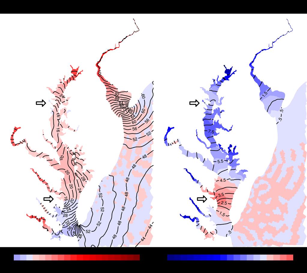
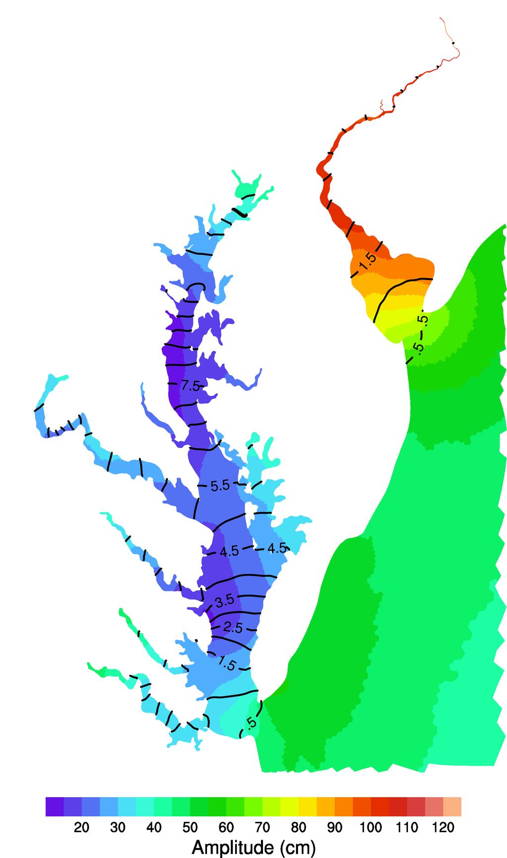
15 M 2 trends Trend (% / century) M2 amplitude Chesapeake Delaware Mid Atlantic Trend (min / century) CBBT Kiptopeke Sewells Point Yorktown Windmill Point Lewisetta Solomons Island Cambridge M2 phase Annapolis Baltimore Tolchester Beach Lewes Cape May Reedy Point Philadelphia Duck Atlantic City Sandy Hook 14 / 23
16 M 2 sensitivity to sea level M2 amplitude 30 Chesapeake Delaware Mid Atlantic A/ h (cm / m) M2 phase φ/ h (min / m) CBBT Kiptopeke Sewells Point Yorktown Windmill Point Lewisetta Solomons Island Cambridge Source: Model Annapolis Baltimore Tolchester Beach Observed Lewes Cape May Reedy Point Philadelphia Duck Atlantic City Sandy Hook 15 / 23
17 M 2 trends, removing sea level 10 M2 amplitude Chesapeake Delaware Mid Atlantic Trend (% / century) Trend (min / century) CBBT Kiptopeke Sewells Point Yorktown Windmill Point Lewisetta Solomons Island Cambridge M2 phase Annapolis Baltimore Tolchester Beach Lewes Cape May Reedy Point Philadelphia Duck Atlantic City Sandy Hook 16 / 23
18 Sea-level rise and background trend are the best explanation for most observed tide changes Things that do not sufficiently explain tide changes: Abrupt, large-scale tide trends River discharge Errors and instrument problems in tide gauge data Dredging and channel deepening (known periods excluded from analysis) 17 / 23
 analytical model. A/ H (cm/m): 18 / 23")
19 Sensitivity to sea level is nearly linear Toffolon and Savenije (2011) analytical model. A/ H (cm/m): 18 / 23

20 But, future changes might depend on inundation Past inundation of wetlands and low-lying areas is insignificant compared to future predictions. Future inundation increases friction, lowering amplitudes. Hall et al. (2013): 19 / 23
21 Conclusions How are tides changing in Delaware and Chesapeake Bays? Different M 2 amplitude trends; many negative M 2 phase trends. What is causing these changes and trends? Combination of sea-level rise and large-scale changes. How might tides change in the future? Large increases possible if no new inundation; smaller changes with inundation. 20 / 23
22 Chen, C., R. C. Beardsley, and G. Cowles, 2006: An unstructured grid, Finite-Volume Coastal Ocean Model (FVCOM) system. Oceanography, 19, Chen, C., H. Liu, and R. C. Beardsley, 2003: An unstructured grid, finite-volume, three-dimensional, primitive equations ocean model: Application to coastal ocean and estuaries. Journal of Atmospheric and Oceanic Technology, 20, Doodson, A. T., 1924: Perturbations of harmonic tidal constants. Proceedings of the Royal Society of London Series A, 106, Ezer, T., and L. P. Atkinson, 2014: Accelerated flooding along the U.S. East Coast: On the impact of sea-level rise, tides, storms, the Gulf Stream, and the North Atlantic Oscillations. Earth s Future, 2, Feng, X., M. N. Tsimplis, and P. L. Woodworth, 2015: Nodal variations and long-term changes in the main tides on the coasts of China. Journal of Geophysical Research: Oceans, 120, Flick, R. E., J. F. Murray, and L. C. Ewing, 2003: Trends in United States tidal datum statistics and tide range. Journal of Waterway, Port, Coastal, and Ocean Engineering, 129, Friedrichs, C. T., and J. E. Perry, 2001: Tidal salt marsh morphodynamics: a synthesis. Journal of Coastal Research, (Special Issue No. 27), Hall, G. F., D. F. Hill, B. Horton, S. E. Engelhart, and W. R. Peltier, 2013: A high-resolution study of tides in the Delaware Bay: Past conditions and future scenarios. Geophysical Research Letters, 40, Jay, D. A., 2009: Evolution of tidal amplitudes in the eastern Pacific Ocean. Geophysical Research Letters, 36, doi: /2008gl Kirwan, M. L., and G. R. Guntenspergen, 2010: Influence of tidal range on the stability of coastal marshland. Journal of Geophysical Research: Earth Surface, 115, doi: /2009jf Li, M., and L. Zhong, 2009: Flood ebb and spring neap variations of mixing, stratification and circulation in Chesapeake Bay. Continental Shelf Research, 29, Müller, M., B. K. Arbic, and J. X. Mitrovica, 2011: Secular trends in ocean tides: Observations and model results. Journal of Geophysical Research, 116, doi: /2010jc Prandle, D., 2004: How tides and river flows determine estuarine bathymetries. Progress in Oceanography, 61, Ray, R. D., 2006: Secular changes of the M2 tide in the Gulf of Maine. Continental Shelf Research, 26, Redman, J. B., 1877: The River Thames. Proceedings of the Institution of Civil Engineers, 49, Rosen, P. S., 1977: Increasing shoreline erosion rates with decreasing tidal range in the Virginia Chesapeake Bay. Chesapeake Science, 18, Scully, M. E., and C. T. Friedrichs, 2007: Sediment pumping by tidal asymmetry in a partially mixed estuary. Journal of Geophysical Research, 112, doi: /2006jc Simpson, J. H., J. Brown, J. Matthews, and G. Allen, 1990: Tidal straining, density currents, and stirring in the control of estuarine stratification. Estuaries, 13, Toffolon, M., and H. H. G. Savenije, 2011: Revisiting linearized one-dimensional tidal propagation. Journal of 21 / 23
23
24
North Atlantic Coast Comprehensive Study (NACCS) APPENDIX A: ENGINEERING
 APPENDIX A: ENGINEERING") North Atlantic Coast Comprehensive Study (NACCS) APPENDIX A: ENGINEERING NORTH ATLANTIC COAST COMPREHENSIVE STUDY: RESILIENT ADAPTATION TO INCREASING RISK Appendix A - Engineering Table of Contents North
North Atlantic Coast Comprehensive Study (NACCS) APPENDIX A: ENGINEERING NORTH ATLANTIC COAST COMPREHENSIVE STUDY: RESILIENT ADAPTATION TO INCREASING RISK Appendix A - Engineering Table of Contents North
Semi-enclosed seas. Estuaries are only a particular type of semi-enclosed seas which are influenced by tides and rivers
 Semi-enclosed seas Estuaries are only a particular type of semi-enclosed seas which are influenced by tides and rivers Other semi-enclosed seas vary from each other, mostly by topography: Separated from
Is sea level rise accelerating in the Chesapeake Bay? A demonstration of a novel new approach for analyzing sea level data
 GEOPHYSICAL RESEARCH LETTERS, VOL. 39,, doi:10.1029/2012gl053435, 2012 Is sea level rise accelerating in the Chesapeake Bay? A demonstration of a novel new approach for analyzing sea level data Tal Ezer
Sensitivity Analysis of Sea Level Rise Simulation To the Ocean Open Boundary Specification Using the 2017 CH3D-ICM
 Sensitivity Analysis of Sea Level Rise Simulation To the Ocean Open Boundary Specification Using the 2017 CH3D-ICM STAC WQSTM Peer Review July 7, 2017 Lew Linker, Ping Wang, Richard Tian, and the CBPO
Prediction of changes in tidal system and deltas at Nakdong estuary due to construction of Busan new port
 Prediction of changes in tidal system and deltas at Nakdong estuary due to construction of Busan new port H. Gm1 & G.-Y. park2 l Department of Civil & Environmental Engineering, Kookmin University, Korea
Sediment Transport at Density Fronts in Shallow Water: a Continuation of N
 DISTRIBUTION STATEMENT A. Approved for public release; distribution is unlimited. Sediment Transport at Density Fronts in Shallow Water: a Continuation of N00014-08-1-0846 David K. Ralston Applied Ocean
WIND EFFECTS ON CHEMICAL SPILL IN ST ANDREW BAY SYSTEM
 WIND EFFECTS ON CHEMICAL SPILL IN ST ANDREW BAY SYSTEM PETER C. CHU, PATRICE PAULY Naval Postgraduate School, Monterey, CA93943 STEVEN D. HAEGER Naval Oceanographic Office, Stennis Space Center MATHEW
Analysis of tidal amplitude changes using the EMD method
 Manuscript (non-latex) Click here to download Manuscript (non-latex) tide_r1_final.pdf 1 Analysis of tidal amplitude changes using the EMD method 2 3 4 5 6 7 Yongcun Cheng 1*, Tal Ezer 1, Larry P. Atkinson
Dynamics of the Ems Estuary
 Dynamics of the Ems Estuary Physics of coastal systems Jerker Menninga 0439738 Utrecht University Institute for Marine and Atmospheric research Utrecht Lecturer: Prof. dr. H.E. de Swart Abstract During
Tony Pratt, DNREC to The Center for the Inland Bays Scientific and Technical Advisory Committee. August 21, 2009
 Sea Level Rise in Delaware Presented by Tony Pratt, DNREC to The Center for the Inland Bays Scientific and Technical Advisory Committee August 21, 2009 Sea level has been fluctuating ever since there have
Coastal Tidal Marshes
 Virginia s Wetlands Coastal Tidal Marshes Hydrology driven by lunar tides; Stresses include tidal inundation and/or salts; Found along high latitudes along intertidal coasts; Comprise ~ 70% wetlands of
IRENE: Visitor from the Extratidal World
 IRENE: Visitor from the Extratidal World John Boon Professor Emeritus Virginia Institute of Marine Science School of Marine science College of William and Mary Hurricane Irene did not come to Hampton Roads
The Science of Sea Level Rise and the Impact of the Gulf Stream
 Old Dominion University ODU Digital Commons July 29, 2016: The Latest in Sea Level Rise Science Hampton Roads Sea Level Rise/Flooding Adaptation Forum 7-29-2016 The Science of Sea Level Rise and the Impact
Coastal Oceanography. Coastal Oceanography. Coastal Waters
 Coastal Oceanography Coastal Oceanography 95% of ocean life is in coastal waters (320 km from shore) Estuaries and wetlands are among most productive ecosystems on Earth Major shipping routes, oil and
Advances in Coastal Inundation Simulation Using Unstructured-Grid Coastal Ocean Models
 Advances in Coastal Inundation Simulation Using Unstructured-Grid Coastal Ocean Models Bob Beardsley (WHOI) Changsheng Chen (UMass-Dartmouth) Bob Weisberg (U. South Florida) Joannes Westerink (U. Notre
An Investigation of the Influence of Waves on Sediment Processes in Skagit Bay
 DISTRIBUTION STATEMENT A. Approved for public release; distribution is unlimited. An Investigation of the Influence of Waves on Sediment Processes in Skagit Bay Geoffrey W. Cowles School for Marine Science
Numerical Experiment on the Fortnight Variation of the Residual Current in the Ariake Sea
 Coastal Environmental and Ecosystem Issues of the East China Sea, Eds., A. Ishimatsu and H.-J. Lie, pp. 41 48. by TERRAPUB and Nagasaki University, 2010. Numerical Experiment on the Fortnight Variation
Critical Issues in Assessment of Offshore Wind Farm Development on Dispersion and Settling of Scallop Larvae in the Northeast U.S.
 Critical Issues in Assessment of Offshore Wind Farm Development on Dispersion and Settling of Scallop Larvae in the Northeast U.S. Coastal Ocean Changsheng Chen School for Marine Science and Technology
FIG Working Week May, Bulgaria From the wisdom of the ages to the challanges of modern world
 FIG Working Week 17-21 May, Bulgaria From the wisdom of the ages to the challanges of modern world COASTAL RISK ANALYSIS OF THE BLACK SEA UNDER THE SEA LEVEL RISE N e v i n B e t u l A V S A R, S e n o
High Resolution Numerical Models of Tidal Marshes in the Delaware Bay
 High Resolution Numerical Models of Tidal Marshes in the Delaware Bay Ramona Stammermann Dept. of Civil, Architectural & Environmental Engineering, Drexel University, Philadelphia, PA Michael Piasecki
Unit 1: Water Systems on Earth Chapter 2
 Unit 1: Water Systems on Earth Chapter 2 Create a mind map with the driving question, Why are Oceans Important? Remember: Why are oceans so important? Why are oceans so important? Primary water source
POLCOMS Metadata for the ARCoES project Keywords: POLCOMS, WAM, residual circulation, waves, Liverpool Bay, UK shelf
 POLCOMS Metadata for the ARCoES project Keywords: POLCOMS, WAM, residual circulation, waves, Liverpool Bay, UK shelf POLCOMS is the Proudman Oceanographic Laboratory Coastal Ocean Modelling System. It
9 th INTECOL Orlando, Florida June 7, 2012
 Restoration of the Everglades Saline Wetlands and Florida Bay: Responses Driven from Land and Sea David Rudnick 1, Colin Saunders 2, Carlos Coronado 2, Fred Sklar 2 Erik Stabenau 1, Vic Engel 1, Rene Price
Oceanography. Oceanography is the study of the deep sea and shallow coastal oceans.
 Oceanography Oceanography is the study of the deep sea and shallow coastal oceans. Studying the Ocean Floor To determine the shape and composition of the ocean floor, scientists use techniques such as
Cookie Settings Accept Cookies
 1 of 10 10/7/2018, 3:07 PM The U.S. East Coast is sinking, worsening floods from sea level rise 2 of 10 10/7/2018, 3:07 PM sea level rise, which has been occurring faster in the western Atlantic Ocean
Science 8 - Water Systems Test - Chapters 1-2
 Science 8 - Water Systems Test - Chapters 1-2 Multiple Choice (30 marks) Identify the choice that best completes the statement or answers the question. 1. What percentage represents the amount of fresh
Regional-scale understanding of the geologic character and sand resources of the Atlantic inner continental shelf, Maine to Virginia
 Regional-scale understanding of the geologic character and sand resources of the Atlantic inner continental shelf, Maine to Virginia Workshop on Dredging, Beach Nourishment and Bird Conservation Atlantic
Research of the Influential Factors on the Simulation of Storm Surge in the Bohai Sea
 Send Orders for Reprints to reprints@benthamscience.net The Open Mechanical Engineering Journal, 2014, 8, 151-156 151 Open Access Research of the Influential Factors on the Simulation of Storm Surge in
EVALUATION OF A THREE-DIMENSIONAL HYDRODYNAMIC MODEL APPLIED TO CHESAPEAKE BAY THROUGH LONG-TERM SIMULATION OF TRANSPORT PROCESSES 1
 AMERICAN WATER RESOURCES ASSOCIATION EVALUATION OF A THREE-DIMENSIONAL HYDRODYNAMIC MODEL APPLIED TO CHESAPEAKE BAY THROUGH LONG-TERM SIMULATION OF TRANSPORT PROCESSES 1 Sung-Chan Kim 2 ABSTRACT: A numerical
Developed in Consultation with Florida Educators
 Developed in Consultation with Florida Educators Table of Contents Next Generation Sunshine State Standards Correlation Chart... 7 Benchmarks Chapter 1 The Practice of Science...................... 11
Australian Coastal Councils Conference
 Australian Coastal Councils Conference 11 March 2015 Estimating Future Coastal Inundation and Erosion Hazards Dr Andrew McCowan Dr Christine Lauchlan-Arrowsmith Warwick Bishop Background Victorian Future
Oceanography II Notes
 Oceanography II Notes Tides The rise and fall in sea level is called a tide. Caused by a giant wave and the gravitational pull of the moon and sun on the ocean One low-tide/high-tide cycle takes about
Subtidal permanently flooded with tidal water. Irregularly exposed surface exposed by tides less often than daily
 Types of Wetlands Tidal Systems COASTAL WETLAND ECOSYSTEMS Tidal Salt Marshes Tidal Freshwater Marshes Mangrove Wetlands Tidal Estuarine Wetland 1 Definition and Formation of Estuaries u Estuary : partially
Types of Wetlands. Tidal Systems
 Types of Wetlands Tidal Systems 1 COASTAL WETLAND ECOSYSTEMS Tidal Salt Marshes Tidal Freshwater Marshes Mangrove Wetlands 2 Tidal Estuarine Wetland 3 Definition and Formation of Estuaries Estuary: : partially
COASTAL DATA APPLICATION
 2015 Coastal GeoTools Proactive By Design. Our Company Commitment COASTAL DATA APPLICATION Projecting Future Coastal Flood Risk for Massachusetts Bay Bin Wang, Tianyi Liu, Daniel Stapleton & Michael Mobile
Oceanography Quiz 2. Multiple Choice Identify the choice that best completes the statement or answers the question.
 Oceanography Quiz 2 Multiple Choice Identify the choice that best completes the statement or answers the question. 1. The highest and lowest tides are known as the spring tides. When do these occur? a.
Past, present and future
 Southern New Jersey and Delaware sea levels: Past, present and future Benjamin P. Horton Sea Level Research Department of Marine and Coastal Science Rutgers University bphorton@marine.rutgers.edu DRIVERS
Ria de Aveiro marginal flooding: dependence on oceanic and fluvial drivers and on morphological evolution
 Ria de Aveiro marginal flooding: dependence on oceanic and fluvial drivers and on morphological evolution C.L. Lopes 1, I. Alvarez 1,2 and J.M. Dias 1 1 carinalopes@ua.pt NMEC, CESAM, Physics Department
Effect of coastal resolution on global estimates of tidal energy dissipation
 Effect of coastal resolution on global estimates of tidal energy dissipation Maialen Irazoqui Apecechea, Martin Verlaan Contents The GTSMv2.0 model Characteristics Major developments Applications Coastal
Modeling New York in D-Flow FM
 Modeling New York in D-Flow FM Delft, 30 th of October 2013 Internship Tuinhof, T.J. (Taco) August - October 2013 Supervisors: Sander Post (Royal HaskoningDHV) Maarten van Ormondt (Deltares) Contents Introduction...
NTHMP Grant Close-Out Narrative Report November 27, Award Number: NA14NWS
 NTHMP Grant Close-Out Narrative Report November 27, 2015 Award Number: NA14NWS4670041 Project Dates: September 1, 2014 August 31, 2015 Recipient: University of Delaware Contact: James T. Kirby Center for
The rate and fate of coastal carbon burial
 The rate and fate of coastal carbon burial Matthew L. Kirwan, Virginia Institute of Marine Science Main Points Marsh size Marsh accretion 1. SLR drives wetland carbon burial in vertical and lateral dimensions
Topics 1. IOOS on the US East Coast. 2. Regional Physical & Ecosystem Modeling Efforts
 Topics 1. IOOS on the US East Coast National Federation of Regional Associations http://usnfra.org - NERACOOS - MACOORA 2. Regional Physical & Ecosystem Modeling Efforts Northeast Regional Association
Coastal Sediment Properties and Longshore Sediment Transport
 Coastal Sediment Properties and Longshore Sediment Transport Julie Rosati Julie.D.Rosati@erdc.usace.army.mil 601-634-3005 Coastal Planning Course Lesson #8 Tuesday 8:00-9:00 am CEM III-1, III-2 1. Coastal
Linking Sediment Transport in the Hudson from the Tidal River to the Estuary
 Linking Sediment Transport in the Hudson from the Tidal River to the Estuary Or, what happened to all the mud from Irene? David Ralston, Rocky Geyer, John Warner, Gary Wall Hudson River Foundation seminar
Estimating the Mean Temperature and Salinity of the Chesapeake Bay Mouth
 Estuaries Vol. 25, No. 1, p. 1 5 February 2002 Estimating the Mean Temperature and Salinity of the Chesapeake Bay Mouth RICARDO A. LOCARNINI,LARRY P. ATKINSON*, and ARNOLDO VALLE-LEVINSON Center for Coastal
Mark L. Botton 1 and Robert E. Loveland 2
 Sea level rise and the significance of marginal beaches for horseshoe crab spawning Mark L. Botton 1 and Robert E. Loveland 2 1 Fordham University, Dept. Natural Sciences and Environmental Science Program
OCEANOGRAPHY II NOTES
 TIDES OCEANOGRAPHY II NOTES MRS. BURKEY EARTH SPACE SCIENCE CY CREEK HS THE RISE AND FALL IN SEA LEVEL IS CALLED A TIDE. CAUSED BY A GIANT WAVE. AVERAGE LOW-TIDE/HIGH-TIDE CYCLE TAKES ABOUT 12 HRS AND
Lu, S., P. Craig, C. Wallen, Z. Liu, A. Stoddard, W. McAnnally and E. Maak. Dynamic Solutions, Knoxville, TN USACOE, Sacramento District
 An Extended-Delta Hydrodynamic Model Framework for Sea Level Rise Analysis to Support Resource Management Planning for the Sacramento-San Joaquin River Delta Lu, S., P. Craig, C. Wallen, Z. Liu, A. Stoddard,
Some Thoughts on the Role of Elevation
 Some Thoughts on the Role of Elevation Data in Sea-level Rise Impact Assessments Rob Thieler* U.S. Geological Survey Coastal and Marine Geology Program Woods Hole, MA *i l d t i l d f D C h D G h *includes
Mapping of tide and tidal flow fields along a tidal channel with vessel-based observations
 JOURNAL OF GEOPHYSICAL RESEARCH, VOL. 109,, doi:10.1029/2003jc001992, 2004 Mapping of tide and tidal flow fields along a tidal channel with vessel-based observations Chunyan Li and Jack Blanton Skidaway
Agenda FVCOM Users Workshop Bedford Institute of Oceanography, Dartmouth October 20-22, Oral Program. Day 1: October 20
 Agenda FVCOM Users Workshop Bedford Institute of Oceanography, Dartmouth October 20-22, 2015 Oral Program 8:30 Registration Day 1: October 20 9:00 Welcome S. Haigh/D. Greenberg Session 1 C. Chen 9:10 A
Ocean facts continued
 Ocean Facts A dynamic system in which many chemical and physical changes take place Formed over millions of years as precipitation filled low areas on Earth called basins and now covers 70% of the Earth
West Florida Shelf and Tampa Bay Responses to Hurricane Irma: What Happened and Why
 West Florida Shelf and Tampa Bay Responses to Hurricane Irma: What Happened and Why R.H. Weisberg Y. Liu J. Chen College of Marine Science University of South Florida St. Petersburg, FL SECOORA Webinar
Sea-level Rise Projections
 Updating Maryland s Sea-level Rise Projections Scientific and Technical Working Group Maryland Climate Change Commission June 26, 2013 1 5 8 16 18 Table of contents Introduction 1 Sea-level Rise and the
Extremes and even Changing Tides. Philip Woodworth, POL. with thanks to Ivan Haigh (Southampton) and Melisa Menendez (Santander)
 and Melisa Menendez (Santander)") Changing Sea Level Means and Extremes and even Changing Tides Philip Woodworth, POL with thanks to Ivan Haigh (Southampton) and Melisa Menendez (Santander) Contents UK Mean Sea Level change revisited Components
Changing Sea Level Means and Extremes and even Changing Tides Philip Woodworth, POL with thanks to Ivan Haigh (Southampton) and Melisa Menendez (Santander) Contents UK Mean Sea Level change revisited Components
L7/ Historical Perspec=ve, Deltas
 Colin Woodroffe (2002) Coasts: Form, Process and Evolu=on, Outline of Chapter 7: L7/1 L7/2 7.1. Historical Perspec=ve, 7.1.1. Deltas Herodotus (450, B.C.) delta = Shape of Nile River Delta = Δ Gilbert
Analysis of Tides and Storm Surge from Observational Records in the Delaware Inland Bays
 Analysis of Tides and Storm Surge from Observational Records in the Delaware Inland Bays John Callahan Delaware Geological Survey Coastal GeoTools Conference March 30 April 2, 2015 Charleston, SC Outline
PREDICTING TROPICAL CYCLONE FORERUNNER SURGE. Abstract
 PREDICTING TROPICAL CYCLONE FORERUNNER SURGE Yi Liu 1 and Jennifer L. Irish 1 Abstract In 2008 during Hurricane Ike, a 2-m forerunner surge, early surge arrival before tropical cyclone landfall, flooded
Predicting the implications of tidal energy barrages: the use of analogues in exploring environmental issues
 Predicting the implications of tidal energy barrages: the use of analogues in exploring environmental issues Roger Morris Bright Angel Coastal Consultants Structure of this presentation Introduction to
Savannah Harbor Expansion Project
 Savannah Harbor Expansion Project Evaluation of Hurricane Surge Impacts with Proposed Mitigation Plan December 2007 Introduction This report summarizes the results of hurricane surge impacts with implementation
West Galveston Bay Regional Sediment Management Plan (An Eco-geomorphologic Approach)
") West Galveston Bay Regional Sediment Management Plan (An Eco-geomorphologic Approach) Juan Moya, Matthew Mahoney and Mike Smith Restore America s Estuaries Conference Tampa, FL, October 23, 2012 Atkins
West Galveston Bay Regional Sediment Management Plan (An Eco-geomorphologic Approach) Juan Moya, Matthew Mahoney and Mike Smith Restore America s Estuaries Conference Tampa, FL, October 23, 2012 Atkins
1.2 DEVELOPMENT OF THE NWS PROBABILISTIC EXTRA-TROPICAL STORM SURGE MODEL AND POST PROCESSING METHODOLOGY
 1.2 DEVELOPMENT OF THE NWS PROBABILISTIC EXTRA-TROPICAL STORM SURGE MODEL AND POST PROCESSING METHODOLOGY Huiqing Liu 1 and Arthur Taylor 2* 1. Ace Info Solutions, Reston, VA 2. NOAA / NWS / Science and
HYDROGRAPHIC AND FLOW STRUCTURE IN THE CHESAPEAKE BAY MOUTH AND PLUME REGION UNDER HIGH FRESHWATER DISCHARGE CONDITIONS. Kristine Holderied *
 HYDROGRAPHIC AND FLOW STRUCTURE IN THE CHESAPEAKE BAY MOUTH AND PLUME REGION UNDER HIGH FRESHWATER DISCHARGE CONDITIONS Kristine Holderied * Arnoldo Valle-Levinson Center for Coastal Physical Oceanography
The Use of Geographic Information Systems to Assess Change in Salt Marsh Ecosystems Under Rising Sea Level Scenarios.
 The Use of Geographic Information Systems to Assess Change in Salt Marsh Ecosystems Under Rising Sea Level Scenarios Robert Hancock The ecological challenges presented by global climate change are vast,
NORTHEAST COASTAL OCEAN FORECAST SYSTEM (NECOFS)
") NORTHEAST COASTAL OCEAN FORECAST SYSTEM (NECOFS) R. C. Beardsley and C. Chen MITSG 13-27 Sea Grant College Program Massachusetts Institute of Technology Cambridge, Massachusetts 02139 NOAA Grant No. NA10OAR4170086
NORTHEAST COASTAL OCEAN FORECAST SYSTEM (NECOFS) R. C. Beardsley and C. Chen MITSG 13-27 Sea Grant College Program Massachusetts Institute of Technology Cambridge, Massachusetts 02139 NOAA Grant No. NA10OAR4170086
Development of Modeling System to Simulate Hydrodynamic and Environmental Quantities in the Hai Phong Estuary, Vietnam
 34 th IAHR World Congress - Balance and Uncertainty 6 June - 1 July 011, Brisbane, Australia 33 rd Hydrology & Water Resources Symposium 10 th Hydraulics Conference Development of Modeling System to Simulate
Storm Surge Computations for the North Carolina Sea Level Rise Risk Management Study
 Storm Surge Computations for the North Carolina Sea Level Rise Risk Management Study A RENCI Technical Report TR-12-04 Brian Blanton, PhD Renaissance Computing Institute (RENCI) University of North Carolina
Section 2.1 Ocean Basins. - Has helped determine where ocean basins are located. - Tectonic plates move changing the position of the continents.
 Science 8 Unit 1: Water Systems on Earth Chapter 2: Oceans Control the Water Cycle Section 2.1 Ocean Basins Oceans are important because: 1. Primary water source for the water cycle 2. Control weather
Influence of morphological changes in a lagoon flooding extension: case study of Ria de Aveiro (Portugal)
") 1158 Lopes, et al. Influence of morphological changes in a lagoon flooding extension: case study of Ria de Aveiro (Portugal) Carina L. Lopes, Sandra Plecha, Paulo A. Silva, and João M. Dias NMEC, CESAM
1158 Lopes, et al. Influence of morphological changes in a lagoon flooding extension: case study of Ria de Aveiro (Portugal) Carina L. Lopes, Sandra Plecha, Paulo A. Silva, and João M. Dias NMEC, CESAM
The Coast: Beaches and Shoreline Processes
 1 2 3 4 5 6 7 8 9 The Coast: es and Shoreline Processes Trujillo & Thurman, Chapter 10 Oceanography 101 Chapter Objectives Recognize the various landforms characteristic of beaches and coastal regions.
Sea-level Rise on Cape Cod: How Vulnerable Are We? Rob Thieler U.S. Geological Survey Woods Hole, MA
 Sea-level Rise on Cape Cod: How Vulnerable Are We? Rob Thieler U.S. Geological Survey Woods Hole, MA Outline Sea-level and coastal processes Past sea-level change Predictions for the future Coastal responses
INVESTIGATION OF LONG-TERM TRANSPORT
 INVESTIGATION OF LONG-TERM TRANSPORT IN TANSHUI RIVER ESTUARY, TAIWAN By Wen-Cheng Liu, 1 Ming-Hsi Hsu, 2 and Albert Y. Kuo, 3 Member, ASCE ABSTRACT: The net, long-term transport of materials in estuaries
Impact of stratification and climatic perturbations to stratification on barotropic tides
 Impact of stratification and climatic perturbations to stratification on barotropic tides Applied & Interdisciplinary Mathematics University of Michigan, Ann Arbor May 23, 213 Supported by funding from:
Year 6. Geography. Revision
 Year 6 Geography Revision November 2017 Rivers and World knowledge How the water cycle works and the meaning of the terms evaporation, condensation, precipitation, transpiration, surface run-off, groundwater
The Coast: Beaches and Shoreline Processes Trujillo & Thurman, Chapter 10
 The Coast: es and Shoreline Processes Trujillo & Thurman, Chapter 10 Oceanography 101 Chapter Objectives Recognize the various landforms characteristic of beaches and coastal regions. Identify seasonal
Understanding The Seafloor. Dr. Frank R. Hall. Resources for pictures, etc. used in this presentation
 Slide 1 Understanding The Seafloor Dr. Frank R. Hall Geological Oceanographer University of New Orleans New Orleans, LA 2003 This is a presentation prepared in the Summer 2003 for the Gulf Coast COSSEE
Applying Gerris to Mixing and Sedimentation in Estuaries
 Applying Gerris to Mixing and Sedimentation in Estuaries Timothy R. Keen U.S. Naval Research Laboratory Stennis Space Center, Mississippi, U.S.A. 4 July 2011 Université Pierre et Marie Curie Paris, France
Casco Bay Estuary Partnership (CBEP) USM Muskie School 34 Bedford St 228B. Portland, ME
 USM Muskie School 34 Bedford St 228B. Portland, ME") Casco Bay Estuary Partnership (CBEP) USM Muskie School 34 Bedford St 228B Wishcamper Center Portland, ME 04104 9300 Malcolm L. Spaulding Applied Science Associates 55 Village Square Drive South Kingstown,
Casco Bay Estuary Partnership (CBEP) USM Muskie School 34 Bedford St 228B Wishcamper Center Portland, ME 04104 9300 Malcolm L. Spaulding Applied Science Associates 55 Village Square Drive South Kingstown,
ΛTKINS. Applications of Regional Sediment Management Concepts in Texas Estuarine Restoration Projects. Riparian Workshop Fort Worth, October 17, 2012
 Juan C Moya, PhD., PG Coastal Planning and Restoration Applications of Regional Sediment Management Concepts in Texas Estuarine Restoration Projects Riparian Workshop Fort Worth, October 17, 2012 West
Projection of Extreme Wave Climate Change under Global Warming
 Hydrological Research Letters, 4, 15 19 (2010) Published online in J-STAGE (www.jstage.jst.go.jp/browse/hrl). DOI: 10.3178/HRL.4.15 Projection of Extreme Wave Climate Change under Global Warming Nobuhito
Primer on Coastal Erosion And Habitat Creation
 2 nd Regional Conference Dredging, Beach Nourishment & Bird Conservation Primer on Coastal Erosion And Habitat Creation Timothy Kana Ph.D Source: Newsday 1962 Photo by Kelsey Aerials 1978 Source: U Mass
Coastal and Hydraulics Laboratory
 ERDC/CHL TR-05-6 Texas City Ship Channel Deepening Study, Hydrodynamic Model Lisa M. Lee, Jennifer N. Tate, and R. C. Berger August 2005 Coastal and Hydraulics Laboratory Approved for public release; distribution
The Delaware Environmental Monitoring & Analysis Center
 The Delaware Environmental Monitoring & Analysis Center Tina Callahan Delaware Estuary Science & Environmental Summit 2013 January 27-30, 2013 What is DEMAC? Delaware Environmental Monitoring & Analysis
Storm surge forecasting and other Met Office ocean modelling
 Storm surge forecasting and other Met Office ocean modelling EMODnet stakeholder meeting Clare O Neill + many others Outline Ocean modelling at the Met Office Storm surge forecasting Current operational
Unit 8 Test Review -- Oceanography
 Unit 8 Test Review -- Oceanography Multiple Choice Identify the choice that best completes the statement or answers the question. D 1. A large body of saline water that may be surrounded by land is a(n)
Modelling the estuarine circulation of the Port of Saint John: Visualizing complex sound speed distribution.
 Modelling the estuarine circulation of the Port of Saint John: Visualizing complex sound speed distribution. Ian CHURCH, John HUGHES CLARKE, Susan HAIGH and Reenu TOODESH, Canada Key words: Hydrodynamic
Supplemental Slides. Shore: Junction of Land & Water. Junction of Land & Water. Sea Level Variations. Shore vs. Coast. Sea Level Variations
 Shore: Junction of Land & Water Supplemental Slides Sediments come off land Most get dumped at the beach Sediment interacts with ocean waves and currents Junction of Land & Water Features: Breaking waves,
Shore: Junction of Land & Water. Sediments come off land Most get dumped at the beach Sediment interacts with ocean waves and currents
 Shore: Junction of Land & Water Supplemental Slides Sediments come off land Most get dumped at the beach Sediment interacts with ocean waves and currents Junction of Land & Water Features: Breaking waves,
Numerical Simulation of Hydrodynamic for Abrupt Bathymetry in Palu River Estuary
 Indian Journal of Science and Technology, Vol 10(29), DOI: 10.17485/ijst/2017/v10i29/116502, August 2017 ISSN (Print) : 0974-6846 ISSN (Online) : 0974-5645 Numerical Simulation of Hydrodynamic for Abrupt
In 1990, 50% of the U.S. population lived within 75 km of a coast. By 2010, 75% of the U.S. population will live within 75 km of a coast.
 In 1990, 50% of the U.S. population lived within 75 km of a coast. By 2010, 75% of the U.S. population will live within 75 km of a coast. High Tech Methods for Surveying the Deep Sea Floor Fig. 20.18 1
HFR Surface Currents Observing System in Lower Chesapeake Bay and Virginia Coast
 HFR Surface Currents Observing System in Lower Chesapeake Bay and Virginia Coast Larry P. Atkinson, Teresa Garner, and Jose Blanco Center for Coastal Physical Oceanography Old Dominion University Norfolk,
A System View of Water Level Processes in the Lower Columbia River
 A System View of Water Level Processes in the Lower Columbia River David Jay Department of Civil & Environmental Engineering Portland State University, Portland, OR Amy Borde and Heida Diefenderfer Pacific
Ocean circulation, sedimentation in the San Juans - compilation of mainstream scientific literature by Dave Hyde -
 Ocean circulation, sedimentation in the San Juans - compilation of mainstream scientific literature by Dave Hyde - Salish Sea has 3 principal estuaries SG, JDF,PS San Juan Islands ocean setting uniquely
Sea Level Rise in Miami-Dade County Florida Implications for Management of Coastal Wetlands and the Everglades
 Sea Level Rise in Miami-Dade County Florida Implications for Management of Coastal Wetlands and the Everglades Peter W. Harlem Dr. John F. Meeder Florida International University Southeast Environmental
Salt intrusion response to changes in tidal amplitude during low river flow in the Modaomen Estuary, China
 IOP Conference Series: Earth and Environmental Science PAPER OPEN ACCESS Salt intrusion response to changes in tidal amplitude during low river flow in the Modaomen Estuary, China To cite this article:
Coupling of Wave and Hydrodynamic Models for Predicting Coastal Inundation: A case study in Jakarta and Semarang
 Coupling of Wave and Hydrodynamic Models for Predicting Coastal Inundation: A case study in Jakarta and Semarang http://peta-maritim.bmkg.go.id/cifdp/maps Nelly Florida Riama,Andri Ramdhani, Andi Eka Sakya,,
Sediment Management in the Coastal Bays
 Sediment Management in the Coastal Bays Introduction Need for ecosystem view of sediment management in Coastal Bays Island loss and restoration Navigation needs Habitat Trade offs Living Shoreline Requirements
SEDIMENT TRANSPORT IN RIVER MOUTH ESTUARY
 SEDIMENT TRANSPORT IN RIVER MOUTH ESTUARY Katsuhide YOKOYAMA, Dr.Eng. dredge Assistant Professor Department of Civil Engineering Tokyo Metropolitan University 1-1 Minami-Osawa Osawa, Hachioji,, Tokyo,
Modeling Tsunami Inundation and Assessing Tsunami Hazards for the U. S. East Coast (Phase 3) NTHMP Semi-Annual Report May 21, 2015
 NTHMP Semi-Annual Report May 21, 2015") Modeling Tsunami Inundation and Assessing Tsunami Hazards for the U. S. East Coast (Phase 3) NTHMP Semi-Annual Report May 21, 2015 Project Progress Report Award Number: NA14NWS4670041 National Weather
Modeling Tsunami Inundation and Assessing Tsunami Hazards for the U. S. East Coast (Phase 3) NTHMP Semi-Annual Report May 21, 2015 Project Progress Report Award Number: NA14NWS4670041 National Weather