Tidal Wetlands & Climate Change
|
|
|
- Brendan Horton
- 5 years ago
- Views:
Transcription
1 Tidal Wetlands & Climate Change Tom Parker (SF State) John Callaway (Univ SF) Lisa Schile (UCB); Ellen Herbert (Indiana U); Evyan Borgnis (USF, SFSU) Jessica Vandenberg (SFSU) Vance Vredenburg (SF State)

2 Data comes from these wetlands
3 What do we know?
4 Observed Species Diversity Increases as Salinity Decreases China Camp Petaluma River Coon Rush Ranch Browns Island Sand Mound Slough Freshwater-Oligo/MesoBrackish Individuals Brackish-Salt Marsh
5 Average Number of Species per Plot (20mx 50m) B B B A A 8 A CC PRM CI RR BRI SMS Site
6 Productivity (g m -2 ) Productivity in strongly reduced by salinity China Camp High salinity Petaluma River Coon Rush Ranch Browns Sand Mound Freshwater
7 Biomass (g/m 3 ) Biomass (g/m 2 ) Belowground biomass is also quite high High Low 0 High Low Petaluma River Marsh Browns Island
8 Inundation reduces productivity when interacting with salinity. Productivity in well-drained and poorly-drained sites Plant height in well-drained and poorly-drained sites Schile et al. Wetlands in press
9 What aspects of climate change will impact SF Bay-Delta tidal wetlands?
10 Climate change and tidal wetlands Increased CO 2 Increased temperatures during growing season Increased rate of sea level rise Increased salinity in brackish and freshwater tidal areas Decreased freshwater flows in summer and fall Salinity stress increases due to summer evapotranspiration
11 What are we sure about? Increasing salinity strongly influences composition, and reduces diversity and productivity Inundation reduces diversity and productivity
12 Can tidal wetlands keep up with sea level rise? Relative Wetland surface elevation

13 Processes contributing to elevation decline Subsidence & compaction Relative Wetland surface elevation Sea Level Rise

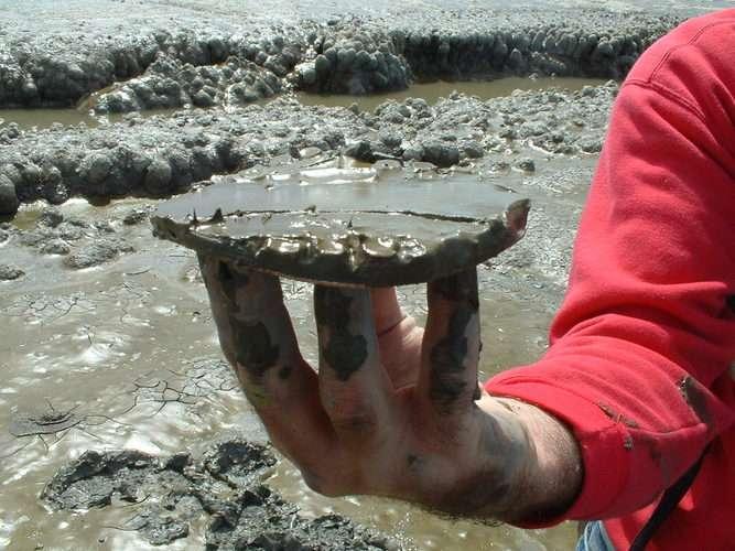
14 Processes contributing to elevation increase Sediment supply Relative Wetland surface elevation Plant organic matter
15 Processes that promote accretion Gains Sediment supply Losses Suspended sediment Erosion Gains Plant organic matter Losses Species composition Below ground productivity Above ground productivity Macrodetritivores Microbial decomposition


16 Gains Sediment supply Losses Suspended sediment Erosion Feldsparmarker horizons SET- Sediment Erosion Tables


17 Gains Plant organic matter Losses Species composition Below ground productivity Above ground productivity Macrodetritivores Microbial decomposition
18 Is sediment supply sufficient?
19 Short-term Sediment Accretion Rates using feldspar markers: MID-MARSH LOCATIONS North Bay rates based on one year of data 3.3 mm/yr 4.9 mm/yr 3.1 mm/yr 2.2 mm/yr 3.4 mm/yr South Bay rates based on six years of data 3.9 mm/yr 5.9 mm/yr

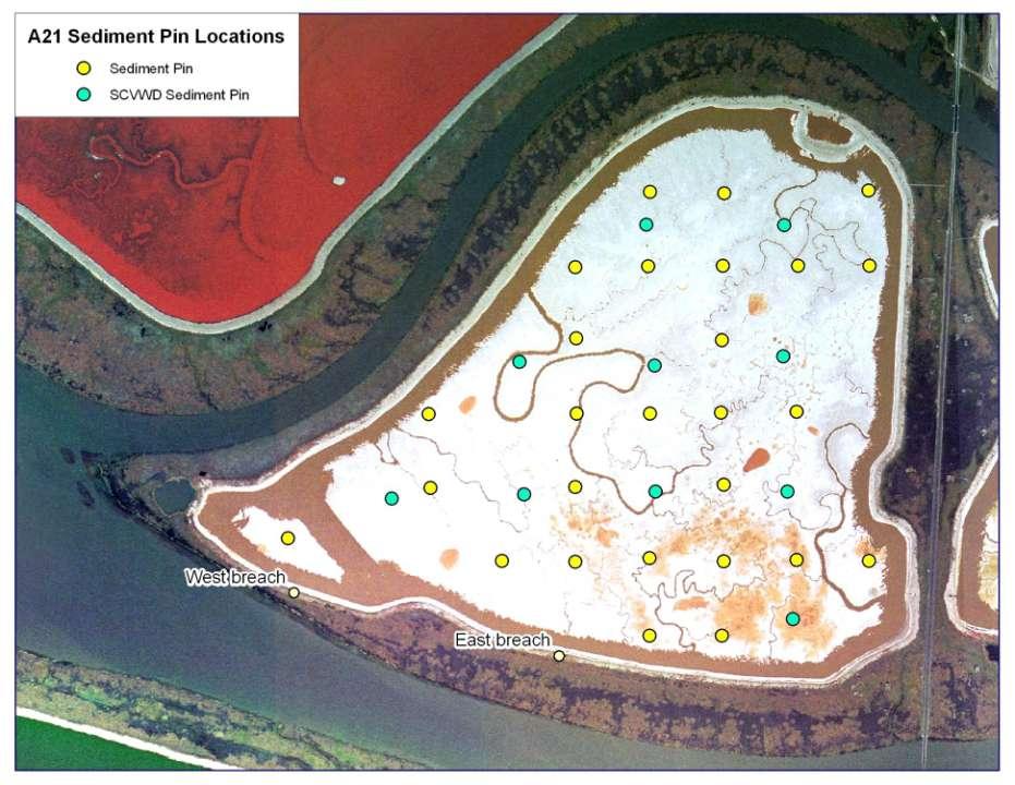
20 Island Ponds Pond A21 Breached March 2006

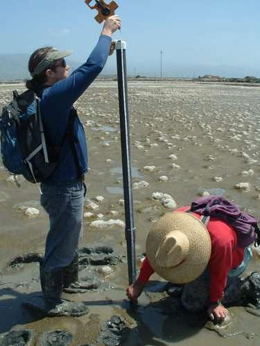
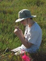
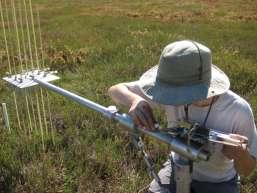
21 Sediment pins
22
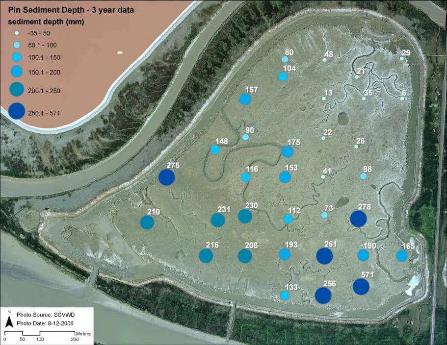
23
24

25 High rates of sedimentation-colonization in the 3 rd year Photos Cris Benton

26 Carl s Marsh at 8 years post-restoration
27 Suspended sediment currently is sufficient; other researcher s estimate it will not keep up with higher rates of sea level rise, especially in some areas of the Bay. Organic matter additions? Very high productivity and high belowground biomass: Decomposition?
28 Freshwater Typha latifolia Saline Current data indicate 5-10% lasting to the end of the second Schoenoplectus year. Differences acutus among species and wetlands decrease. Sarcocornia pacifica

29 Long-term Sediment Accretion Rates ( 137 Cs and 210 Pb dating-) 1-3 mm/yr 1-3 mm/yr These values incorporate sediment, organic matter and compaction 5 mm/yr* Data from Callaway et al. (unpublished) *data or *Patrick from and Patrick Lehune and (1990) DeLaune (1990) 4 mm/yr* 3-4 mm/yr 3-6 mm/yr 42 mm/yr*
30 Gaps in our knowledge CO 2 Temperature Impact on plant physiology and interactions
31 Impacts of CO 2 Plant resource, especially for C3 plants Shown to stimulate root growth in 2 experiments (Maryland, Louisiana)
32 Direct effects-temperature Influence on photosynthesis/respiration balance of dominant plants rate photosynthesis respiration temperature
33 Direct effects-temperature Influence on photosynthesis/respiration balance of dominant plants Increase in ANPP rate Decrease in ANPP Mortality temperature
34 Interactions among all these processes?
Sediment Dynamics in Restored Tidal Wetlands of San Francisco Bay
 Sediment Dynamics in Restored Tidal Wetlands of San Francisco Bay John Callaway & Jennifer Gagnon (USF) Lisa Schile (UC Berkeley) Evyan Borgnis & Tom Parker (SFSU) Donna Ball (HT Harvey & Assoc.) Gene
Pablo Bay in Sonoma, Solano, and Napa Counties. It is owned and managed by the U.S. Fish and Wildlife
 Appendix L San Pablo Bay Marsh Introduction San Pablo Bay National Wildlife Refuge marsh (hereafter San Pablo) is located on the north shore of San Pablo Bay in Sonoma, Solano, and Napa Counties. It is
DYNAMICS OF SEDIMENT ACCUMULATION IN POND A21 AT THE ISLAND PONDS
 DYNAMICS OF SEDIMENT ACCUMULATION IN POND A21 AT THE ISLAND PONDS John C. Callaway 1 V. Thomas Parker 2 Lisa M. Schile 3 Ellen R. Herbert 2 Evyan L. Borgnis 1 Submitted to: Ann Buell California State Coastal
Wetland Sediment Dynamics at Crissy Field Marsh Annual Report
 Wetland Sediment Dynamics at Crissy Field Marsh 27 Annual Report John Callaway Department of Environmental Science University of San Francisco 217 Fulton St. San Francisco, CA 94117 (415) 422-572 callaway@usfca.edu
9 th INTECOL Orlando, Florida June 7, 2012
 Restoration of the Everglades Saline Wetlands and Florida Bay: Responses Driven from Land and Sea David Rudnick 1, Colin Saunders 2, Carlos Coronado 2, Fred Sklar 2 Erik Stabenau 1, Vic Engel 1, Rene Price
Coastal Tidal Marshes
 Virginia s Wetlands Coastal Tidal Marshes Hydrology driven by lunar tides; Stresses include tidal inundation and/or salts; Found along high latitudes along intertidal coasts; Comprise ~ 70% wetlands of
Taunton River Salt Marsh Assessment Results from 2014 season
 Taunton River Salt Marsh Assessment Results from 2014 season December, 2014 During the late summer and fall of 2014, Save The Bay evaluated salt marshes in Assonet Bay, Freetown and Broad Cove in Dighton
The rate and fate of coastal carbon burial
 The rate and fate of coastal carbon burial Matthew L. Kirwan, Virginia Institute of Marine Science Main Points Marsh size Marsh accretion 1. SLR drives wetland carbon burial in vertical and lateral dimensions
Some Thoughts on the Role of Elevation
 Some Thoughts on the Role of Elevation Data in Sea-level Rise Impact Assessments Rob Thieler* U.S. Geological Survey Coastal and Marine Geology Program Woods Hole, MA *i l d t i l d f D C h D G h *includes
Elkhorn Slough Marsh Stratigraphy
 Elkhorn Slough Marsh Stratigraphy Prehistoric marsh extent & recent sediment accretion Elizabeth Burke Watson, Ph.D. U.S. Environmental Protection Agency Narragansett, RI Paleoecology: Reconstruction of
Planning for the Future of Humboldt Bay: Sea Level Rise, Sediment Management, Sand Spits and Salt Marshes. Joel Gerwein
 Planning for the Future of Humboldt Bay: Sea Level Rise, Sediment Management, Sand Spits and Salt Marshes Joel Gerwein Introduction to Humboldt Bay Setting Economy, community, and environment Sediment
Nutrient and Carbon Sequestration by Salt Marsh Plants in the Face of Eutrophication and Sea Level Rise
 Nutrient and Carbon Sequestration by Salt Marsh Plants in the Face of Eutrophication and Sea Level Rise Tracy Elsey, Jack Gallagher, and Denise Seliskar Halophyte Biotechnology Center College of Marine
Should (R)SET-MH data be used to forecast the effects of sea level rise on wetland resilience and carbon sequestration?
SET-MH data be used to forecast the effects of sea level rise on wetland resilience and carbon sequestration?") Should (R)SET-MH data be used to forecast the effects of sea level rise on wetland resilience and carbon sequestration? Randall W. Parkinson, Ph.D., P.G. Institute for Water and Environment Florida International
Should (R)SET-MH data be used to forecast the effects of sea level rise on wetland resilience and carbon sequestration? Randall W. Parkinson, Ph.D., P.G. Institute for Water and Environment Florida International
Considering Nitrogen and Black Mangrove in Context: Lessons Learned
 Considering Nitrogen and Black Mangrove in Context: Lessons Learned Christine N. Pickens 1 Karen L. McKee 2 Mark W. Hester 1 1 Coastal Plant Ecology Laboratory, University of Louisiana at Lafayette 2 US
Estuarine marshes along the Elbe: past, present and future
 Universität Hamburg Deltas and Climate Change - : past, present and future Kai Jensen & S. Albrecht, Chr. Butzeck, G. Engels, F. Müller, U. Schröder Universität Hamburg kai.jensen@botanik.uni-hamburg.de
IS THERE ENOUGH SEDIMENT? Presentation at the State of the Estuary Conference San Francisco, CA, October 9-10, By Philip B.
 IS THERE ENOUGH SEDIMENT? Presentation at the State of the Estuary Conference San Francisco, CA, October 9-10, 2001 By Philip B. Williams 1. INTRO I AM TEMPTED TO MAKE THIS THE SHORTEST TALK OF THE CONFERENCE:
APPENDIX F SEDIMENT DEPOSITION AND HABITAT CONVERSION ANALYSIS
 APPENDIX F SEDIMENT DEPOSITION AND HABITAT CONVERSION ANALYSIS San Dieguito Lagoon W-19 Restoration Project Draft EIR March 2017 Appendices Introduction: The following is an analysis to provide the volume
Carbon Sequestration Potential from Coastal Wetlands Restoration Sites
 Carbon Sequestration Potential from Coastal Wetlands Restoration Sites Insert then choose Picture select your picture. Right click your picture and Send to back. Paul Krause, Alyssa Beach Emily Cooper,
Assessing marsh response from sea-level rise applying local site conditions: Humboldt Bay wetlands
 Assessing marsh response from sea-level rise applying local site conditions: Humboldt Bay wetlands U. S. Geological Survey, Western Ecological Research Center Addendum - Data Summary Report February 23,
Types of Wetlands. Tidal Systems
 Types of Wetlands Tidal Systems 1 COASTAL WETLAND ECOSYSTEMS Tidal Salt Marshes Tidal Freshwater Marshes Mangrove Wetlands 2 Tidal Estuarine Wetland 3 Definition and Formation of Estuaries Estuary: : partially
Subtidal permanently flooded with tidal water. Irregularly exposed surface exposed by tides less often than daily
 Types of Wetlands Tidal Systems COASTAL WETLAND ECOSYSTEMS Tidal Salt Marshes Tidal Freshwater Marshes Mangrove Wetlands Tidal Estuarine Wetland 1 Definition and Formation of Estuaries u Estuary : partially
Efficiency in assessment and monitoring methods: scaling down gradient-directed transects
 Efficiency in assessment and monitoring methods: scaling down gradient-directed transects V. THOMAS PARKER, 1, LISA M. SCHILE, 1,3 MICHAEL C. VASEY, 1 AND JOHN C. CALLAWAY 2 1 Department of Biology, San
netw rks Guided Reading Activity Essential Question: How does geography influence the way people live? Earth's Physical Geography
 Guided Reading Activity Lesson 1 Earth and the Sun Essential Question: How does geography influence the way people live? Looking at Earth Directions: What are the layers that make up Earth? Use your textbook
Optimal Design of Sediment Diversions for Delta Restoration: lessons learned from examples
 Optimal Design of Sediment Diversions for Delta Restoration: lessons learned from examples Samuel Bentley 1, Angelina Freeman 2, Clinton S. Willson 1, Liviu Giosan 3, Jaye Cable 4 1 LSU 2 EDF 3 WHOI 4
Home About Us Articles Press Releases Image Gallery Contact Us Media Kit Free Subscription 10/5/2006 5:56:35 PM
 Home About Us Articles Press Releases Image Gallery Contact Us Media Kit Free Subscription 10/5/2006 5:56:35 PM Industry Resources Industry Directory NASA Links Missions/Launches Calendar Human development
Limits and Potentials of High Resolution Terrestrial Laser Scanning in Monitoring Estuarine Geomorphologic Variability.
 Limits and Potentials of High Resolution Terrestrial Laser Scanning in Monitoring Estuarine Geomorphologic Variability Charlie Endris January 20, 2010 Elkhorn Slough: Erosion and Habitat Loss Evolution
The Role of the Mangrove Ecotone Region in Regulating Nutrient Cycling and Wetland Productivity in South Florida
 The Role of the Mangrove Ecotone Region in Regulating Nutrient Cycling and Wetland Productivity in South Florida Victor H. Rivera-Monroy, Stephen E. Davis III, Robert R. Twilley, Daniel L. Childers, Marc
Landscapes & Hydric Soils Bruce Vasilas University of Delaware
 Landscapes & Hydric Soils Bruce Vasilas University of Delaware Hydric soils are defined as soils that formed under conditions of saturation, flooding, or ponding long enough during the growing season to
Ecosystems Chapter 4. What is an Ecosystem? Section 4-1
 Ecosystems Chapter 4 What is an Ecosystem? Section 4-1 Ecosystems Key Idea: An ecosystem includes a community of organisms and their physical environment. A community is a group of various species that
COASTAL WETLAND ENGINEERING: DESIGNING FOR FUNCTION, CASE STUDIES, AND MODELING TOOLS
 COASTAL WETLAND ENGINEERING: DESIGNING FOR FUNCTION, CASE STUDIES, AND MODELING TOOLS Candice Piercy, PhD, PE Susan Bailey, PE ERDC - Environmental Laboratory TAMU Ocean Engineering EWN Lecture Series
UNIT 2 WARM UP. List the OCEANS. Bonus: Name the Largest LAKE on Earth
 UNIT 2 WARM UP List the OCEANS Bonus: Name the Largest LAKE on Earth Land Forms Land Mountain Hill Cliff Butte Mesa Plateau Cave Volcano Desert Plains Prairie Steppe Marsh Swamp Tundra Glacier Continent
ABSTRACT TRENDS IN ESTUARINE WETLANDS AND RELATIONSHIPS TO SALINITY AND SEDIMENT STRATIGRAPHY. Leah Hope-Menzies Beckett, Doctor of Philosophy, 2012
 ABSTRACT Title of dissertation: SUBSIDENCE, ACCRETION, AND ELEVATION TRENDS IN ESTUARINE WETLANDS AND RELATIONSHIPS TO SALINITY AND SEDIMENT STRATIGRAPHY Leah Hope-Menzies Beckett, Doctor of Philosophy,
Using Remote Sensing to Map the Evolution of Marsh Vegetation in the South Bay of San Francisco
 Using Remote Sensing to Map the Evolution of Marsh Vegetation in the South Bay of San Francisco Brian Fulfrost Design, Community and Environment (DC&E) 6 th Annual Bay-Delta Science Conference PROJECT
USGS efforts to model sea-level rise impact to tidal marshes along the California coast.
 USGS efforts to model sea-level rise impact to tidal marshes along the California coast. Karen Thorne 1 J.Y Takekawa 1, K. Buffington 1, K. Swanson 2, J. Drexler 2, D.Schoellhamer 2, M. Casazza 3, and
Connectivity Between the Mangrove Ecotone Region and Florida Bay: Current Understanding in Carbon and Nutrient Fluxes
 Connectivity Between the Mangrove Ecotone Region and Florida Bay: Current Understanding in Carbon and Nutrient Fluxes Victor H. Rivera-Monroy, Stephen E. Davis III, Robert R. Twilley, Daniel L. Childers,
Regional Sediment Management Science Workshop: Sediment in San Francisco Bay
 Regional Sediment Management Science Workshop: Sediment in San Francisco Bay Purpose Co-sponsored by BCDC and USGS April 19-20, 2010 at USGS, Menlo Park, CA Discuss recent scientific results related to
CHAPTER 6 & 7 VOCABULARY
 CHAPTER 6 & 7 VOCABULARY 1. Biome 2. Climate 3. Latitude 4. Altitude 5. Emergent layer 6. Epiphyte 7. Understory 8. Permafrost 9. Wetland 10.Plankton 11.Nekton 12.Benthos 13.Littoral zone 14.Benthic zone
Shoreline and Climate Change Adaptation Alternatives for The Letter Parcel, Bolinas Lagoon
 Shoreline and Climate Change Adaptation Alternatives for The Letter Parcel, Bolinas Lagoon Scenic shoreline vista of Bolinas Lagoon and ridges, from Letter Parcel, March 2016 Peter Baye, Coastal Ecologist
Generalized Conceptual Models Wetlands Regional Monitoring Program Compiled for the PEEIR
 1 Generalized Conceptual Models Wetlands Regional Monitoring Program 2002 Compiled for the PEEIR 2 1. MANAGEMENT QUESTIONS DRIVE INDICATOR DEVELOPMENT The overarching wetland management questions are:
Sediment Management in the Coastal Bays
 Sediment Management in the Coastal Bays Introduction Need for ecosystem view of sediment management in Coastal Bays Island loss and restoration Navigation needs Habitat Trade offs Living Shoreline Requirements
Mangrove Restoration and Migration in a Changing Climate: Climatic Drivers and Shifting Ecotones
 Mangrove Restoration and Migration in a Changing Climate: Climatic Drivers and Shifting Ecotones Michael J. Osland & Richard H. Day U.S. Geological Survey, National Wetlands Research Center U.S. Department
Reducing Nitrogen Removal Uncertainty for Operation of Mississippi River Sediment Diversions: Nitrate Reduction Rates In Turbulent Flow Conditions
 Reducing Nitrogen Removal Uncertainty for Operation of Mississippi River Sediment Diversions: Nitrate Reduction Rates In Turbulent Flow Conditions Nia R. Hurst, John R. White, Kehui Xu, and MingCheng Ren
Lu, S., P. Craig, C. Wallen, Z. Liu, A. Stoddard, W. McAnnally and E. Maak. Dynamic Solutions, Knoxville, TN USACOE, Sacramento District
 An Extended-Delta Hydrodynamic Model Framework for Sea Level Rise Analysis to Support Resource Management Planning for the Sacramento-San Joaquin River Delta Lu, S., P. Craig, C. Wallen, Z. Liu, A. Stoddard,
GLOBAL WARMING: GLOBAL WARMING. landscape implications. Andrew Goudie St Cross College Oxford
 GLOBAL WARMING: GLOBAL WARMING landscape implications Andrew Goudie St Cross College Oxford THE PROCESS OF CHANGE HAS STARTED IPCC 2007 Increased Glacier retreat since the early 1990s Area of seasonally
Baseline Estuarine-Upland Transition Zone
 Baseline Estuarine-Upland Transition Zone in SF, San Pablo and Suisun Bays 10/5/18 Prepared for San Francisco Bay Joint Venture (SFBJV) Prepared by Brian Fulfrost, Principal bfaconsult@gmail.com with additional
An Integrated Storm Surge, Hurricane Wave, Salinity and Sediment Transport Modeling System for Breton Sound, LA
 An Integrated Storm Surge, Hurricane Wave, Salinity and Sediment Transport Modeling System for Breton Sound, LA Q. Jim Chen Department of Civil and Environmental Engineering qchen@lsu.edu Acknowledgements
Design of Levee Breaches in Sheltered Water for Flood Risk Reduction & Marsh Restoration ASFMP; June 5, 2014 Presented By:
 Design of Levee Breaches in Sheltered Water for Flood Risk Reduction & Marsh Restoration ASFMP; June 5, 2014 Presented By: Rohin Saleh Alameda County Flood Control District Matt Powers, P.E. GEI Consultants
Australian Coastal Councils Conference
 Australian Coastal Councils Conference 11 March 2015 Estimating Future Coastal Inundation and Erosion Hazards Dr Andrew McCowan Dr Christine Lauchlan-Arrowsmith Warwick Bishop Background Victorian Future
4.2 Tidal Wetlands. Phragmites Australis
 4.2 Tidal Wetlands Few topics elicit such strong emotions in Guilford as the current state of salt marshes. These marshes, more broadly known as tidal wetlands, are undergoing a transformation as sea level
Improving marsh restoration: leaf tissue chemistry identifies factors limiting production in Spartina patens
 Plant Ecol (2010) 207:141 148 DOI 10.1007/s11258-009-9660-x Improving marsh restoration: leaf tissue chemistry identifies factors limiting production in Spartina patens V. D. Tobias Æ J. A. Nyman Æ R.
The Coast: Beaches and Shoreline Processes
 1 2 3 4 5 6 7 8 9 The Coast: es and Shoreline Processes Trujillo & Thurman, Chapter 10 Oceanography 101 Chapter Objectives Recognize the various landforms characteristic of beaches and coastal regions.
The Coast: Beaches and Shoreline Processes Trujillo & Thurman, Chapter 10
 The Coast: es and Shoreline Processes Trujillo & Thurman, Chapter 10 Oceanography 101 Chapter Objectives Recognize the various landforms characteristic of beaches and coastal regions. Identify seasonal
Tidal Wetland Vegetation
 Wetlands Regional Monitoring Program Plan 00 Data Collection Protocol Michael Vasey San Francisco State University San Francisco CA John Callaway University of San Francisco San Francisco CA V. Thomas
Coastal Processes 101 & The Regs. Greg Berman (Woods Hole Sea Grant & Cape Cod Cooperative Extension)
") Coastal Processes 101 & The Regs Greg Berman (Woods Hole Sea Grant & Cape Cod Cooperative Extension) March 26, 2019 Coastal Processes 101 & The Regs Outline: ~15 min talk Coastal Processes What is Erosion?
Coastal Processes 101 & The Regs Greg Berman (Woods Hole Sea Grant & Cape Cod Cooperative Extension) March 26, 2019 Coastal Processes 101 & The Regs Outline: ~15 min talk Coastal Processes What is Erosion?
Ground Water Control of Tree Island Origin, Genesis and Destruction. By John F. Meeder and Peter W. Harlem SERC,FIU
 Ground Water Control of Tree Island Origin, Genesis and Destruction By John F. Meeder and Peter W. Harlem SERC,FIU Functional Definition Our functional definition of a Tree Island is; an isolated scrub
Eco-hydromorphic Characterization of the Louisiana Coastal Region Using Multiple Remotely Sensed Data Sources and Analyses
 National Wetlands Research Center Eco-hydromorphic Characterization of the Louisiana Coastal Region Using Multiple Remotely Sensed Data Sources and Analyses 1Holly Beck, 2 Brady Couvillion, 1 Nadine Trahan
Introduction to the Hydrogeomorphic (HGM) Classification System
 Classification System") Introduction to the Hydrogeomorphic (HGM) Classification System Objectives The Student Will be Able to: Define the 7 HGM Classes List the 3 Parameters That Define HGM Classes List the Major Water Budget
Introduction to the Hydrogeomorphic (HGM) Classification System Objectives The Student Will be Able to: Define the 7 HGM Classes List the 3 Parameters That Define HGM Classes List the Major Water Budget
Freshwater-Tidal Gradients: Eco-geomorphology Linkages to Watershed-Estuarine Dynamics
 Freshwater-Tidal Gradients: Eco-geomorphology Linkages to Watershed-Estuarine Dynamics Kathy Boomer (The Nature Conservancy) Scott Ensign (Stroud Research) Greg Noe (USGS) Concluding Speculations: It s
VEGETATION EVA BOEHRINGER
 VEGETATION EVA BOEHRINGER April 2, 2014 WUP CONSULTATIVE COMMITTEE WUP Consultative Committee (WUP CC) recognized that riparian and wetland vegetation in the reservoir drawdown zone is valuable for fish,
Section 145 Climate Change and Sea Level Rise
 Section 145 Climate Change and Sea Level Rise A. Definitions Rhode Island Coastal Resources Management Program 1. Climate is the long-term weather average observed within a geographic region, and climate
W he natural resources of Adams
 Above: Houghton Rock, Town of Adams. Following Page: "The Hole in the Rock" on Rattlesnake Mound--both remnants of rock formed by ancient seas hundreds of millions of year5 ago. (Courtesy, H.H. Bennett
II Why study coastal landforms?
 COASTAL LANDFORMS (32) I Main topics A Why study coastal landforms? B Sediment budget and system response C Coastal landforms 3/26/15 GG454 1 II Why study coastal landforms? A Dynamic systems B Reflect
The Mississippi River: Its Role in Restoration Efforts and Potential Effects of Climate Change
 The Mississippi River: Its Role in Restoration Efforts and Potential Effects of Climate Change Clinton S. Willson, P.E., Ph.D. Department of Civil & Environmental Engineering Louisiana State University
AN ASSESSMENT OF RIVER RESOURCES FOR LOUISIANA COASTAL LAND PRESERVATION
 AN ASSESSMENT OF RIVER RESOURCES FOR LOUISIANA COASTAL LAND PRESERVATION Approved for Public Release; distribution unlimited Biedenharn Group, LLC Vicksburg, Mississippi Report Documentation Page Form
From micro to macro scale the impact on the sediment discharge after construction of the Three Gorges Dam on Yangtze River (Changjiang)
") From micro to macro scale the impact on the sediment discharge after construction of the Three Gorges Dam on Yangtze River (Changjiang) Aleksandra Dewiszek 9th International SedNet conference Solving societal
From micro to macro scale the impact on the sediment discharge after construction of the Three Gorges Dam on Yangtze River (Changjiang) Aleksandra Dewiszek 9th International SedNet conference Solving societal
Life EBRO-ADMICLIM: Adaptation and mitigation measures to climate change in the Ebro Delta
 Life EBRO-ADMICLIM: Adaptation and mitigation measures to climate change in the Ebro Delta Dr. Carles Ibáñez IRTA Aquatic Ecosystems Program 04/12/2014 0 Summary 1) Global change pressures in deltas 2)
Primer on Coastal Erosion And Habitat Creation
 2 nd Regional Conference Dredging, Beach Nourishment & Bird Conservation Primer on Coastal Erosion And Habitat Creation Timothy Kana Ph.D Source: Newsday 1962 Photo by Kelsey Aerials 1978 Source: U Mass
Sea-level Rise on Cape Cod: How Vulnerable Are We? Rob Thieler U.S. Geological Survey Woods Hole, MA
 Sea-level Rise on Cape Cod: How Vulnerable Are We? Rob Thieler U.S. Geological Survey Woods Hole, MA Outline Sea-level and coastal processes Past sea-level change Predictions for the future Coastal responses
Port Susan Bay Estuary Restoration Project Post Construction Monitoring
 Port Susan Bay Estuary Restoration Project Post Construction Monitoring The Nature Conservancy ESRP Project: Port Susan Bay Estuary Restoration ESRP, RCO #11-1650R, Amendment #2 The Port Susan Bay Dike
Coastal Ecosystems: Salt Marshes and Mangroves. Marine Biology Dr. Ouida Meier
 Coastal Ecosystems: Salt Marshes and Mangroves Marine Biology Dr. Ouida Meier Factors Driving Coastal Ecosystems Latitude temperature light, seasonality Tidal cycles amplitude frequency Wave energy Degree
Critical Coastal Habitat Assessment. Long-term monitoring in Tampa Bay
 Critical Coastal Habitat Assessment Long-term monitoring in Tampa Bay Kara Radabaugh, Ryan Moyer, Ed Sherwood, Gary Raulerson, Amanda Chappel, Taylor Nielsen, Reba Campbell, and Emma Dontis. Critical Coastal
Assessing the Permanence of Blue Carbon Sinks
 Assessing the Permanence of Blue Carbon Sinks with Rising Sea Levels Gail L. Chmura and Dante D. Torio Department of Geography, McGill University and Global Environmental and Climate Change Centre Montreal,
Extreme Weather Events: Infrastructure Damage and Impact on Vulnerable Populations
 Extreme Weather Events: Infrastructure Damage and Impact on Vulnerable Populations Cindy L. Parker MD, MPH Physicians for Social Responsibility Johns Hopkins Bloomberg School of Public Health 1 Climate
2017 Delaware Estuary Science and Environmental Summit Cape May, NJ January
 2017 Delaware Estuary Science and Environmental Summit Cape May, NJ January 22 25 2017 Beatrice O Hara Dr. Daria Nikitina, Advisor West Chester University of Pennsylvania Department of Earth and Space
Eco Bay Pathways Watershed related exhibits in the Exploratorium
 Eco Bay Pathways Watershed related exhibits in the Exploratorium This Pathwa y is a guide to engagement wi th museu m exhibit s at the Explo ratorium and includes activiti es for p re- an d post-fi eldtri
Morro Bay National Estuary Program. Sediment Monitoring Report 2016
 Morro Bay National Estuary Program Sediment Monitoring Report 2016 Prepared by Morro Bay National Estuary Program 601 Embarcadero, Suite 11 Morro Bay, CA 93442 October 2017 TABLE OF CONTENTS Executive
What two factors have the most important effect on a region's climate?
 Chapter 4 - Kinds of Ecosystems 4.1 Forests biome - climate - weather conditions - What two factors have the most important effect on a region's climate? Types of Forests Tropical Rain Forests location
7.3 Paleoenvironmental History of Jamaica Bay Marshes, New York
 7.3 Paleoenvironmental History of Jamaica Bay Marshes, New York Dorothy Peteet and Louisa Lieberman 7.3.1 INTRODUCTION Jamaica Bay Wildlife Refuge, a U.S. National Park, is internationally and nationally
SUMMARY. Sediment Properties Grain Sizes and Densities Bulk Density, Cohesion, Strength. Compaction & Dewatering
 Wind Waves and Wetlands Workshop: Assessing the Need for and Approaches to Attenuate Wind-Wave Energy in Tidal Wetland Systems March 18, 2008, San Francisco, CA Sponsors: San Francisco Bay Conservation
Tony Pratt, DNREC to The Center for the Inland Bays Scientific and Technical Advisory Committee. August 21, 2009
 Sea Level Rise in Delaware Presented by Tony Pratt, DNREC to The Center for the Inland Bays Scientific and Technical Advisory Committee August 21, 2009 Sea level has been fluctuating ever since there have
Influence of the Major Drainages to the Mississippi River and Implications for System Level Management
 Influence of the Major Drainages to the Mississippi River and Implications for System Level Management Brian M. Vosburg Geologist Louisiana Coastal Protection and Restoration Authority brian.vosburg@la.gov
2.1. Site-Specific Scenarios for Wetlands Accretion as Sea Level Rises in the Mid-Atlantic Region
 2.1. Site-Specific Scenarios for Wetlands Accretion as Sea Level Rises in the Mid-Atlantic Region Authors: Denise J. Reed Dana A. Bishara Department of Earth and Environmental Sciences, University of New
Coastal Vulnerability and Risk Parameters
 European Water 11/12: 3-7, 2005. 2005 E.W. Publications Coastal Vulnerability and Risk Parameters E. Doukakis National Technical University of Athens-Dept. of Rural and Surveying Engineering, Lab. of Higher
Beneficial Reuse of Dredge Material for Salt Marsh Restoration: Early Recovery of Vegetation and Epifaunal Macroinvertebrate
 Metthea Yepsen myepsen@tnc.org Adrianna Zito-Livingston Jessie Buckner Projects funded by New Jersey Department of Environmental Protection and Department of Transportation, The National Fish and Wildlife
HISTORIC SEDIMENT ACCRETION RATES IN A LOUISIANA COASTAL MARSH AND IMPLICATIONS FOR SUSTAINABILITY. A Thesis
 HISTORIC SEDIMENT ACCRETION RATES IN A LOUISIANA COASTAL MARSH AND IMPLICATIONS FOR SUSTAINABILITY A Thesis Submitted to the Graduate Faculty of the Louisiana State University and Agricultural and Mechanical
Whiskey Island Marsh Creation Rolling with the Punches
 Whiskey Island Marsh Creation Rolling with the Punches Santiago Alfageme, M&N Jerry Carroll, LADNR Brad Miller, LADNR Project Location Historic Island Retreat Previous Restoration Project Whiskey Island
Descriptions and Performance
 LSU AgCenter Coastal Plants Program Smooth Cordgrass Varieties: Descriptions and Performance Smooth cordgrass (Spartina alterniflora Loisel.) is a perennial grass native to intertidal saline marshes along
Canary in the Coal Mine: Subsidence in Coastal Louisiana Press Conference
 Canary in the Coal Mine: Subsidence in Coastal Louisiana Press Conference Samuel Bentley, LSU Department of Geology & Geophysics professor and Billy and Ann Harrison chair in sedimentary geology Mead Allison,
ERDC/LAB TR-0X-X 100. Figure 7-3 Maximum velocity magnitudes for existing conditions for 100-year flood event
 ERDC/LAB TR-0X-X 100 Figure 7-3 Maximum velocity magnitudes for existing conditions for 100-year flood event ERDC/LAB TR-0X-X 101 Figure 7-4 Model schematization of Option 1 Figure 7-5 Bed displacement
MEMORANDUM FOR SWG
 MEMORANDUM FOR SWG-2007-1623 Subject: Jurisdictional Determination (JD) for SWG-2007-1623 on Interdunal Wetlands Adjacent to Traditional Navigable Waters (TNWs) Summary The U.S. Environmental Protection
MARK SCHEME for the October/November 2015 series 9693 MARINE SCIENCE
 CAMBRIDGE INTERNATIONAL EXAMINATIONS Cambridge International Advanced Subsidiary Level MARK SCHEME for the October/November 2015 series 9693 MARINE SCIENCE 9693/01 Paper 1 (AS Structured Questions), maximum
A Thesis. The Department of Oceanography and Coastal Sciences. by Lauren Land B.S., University of Maryland College Park, 2008 December 2010
 PHYSICAL AND MICROBIAL RESPONSES OF DREDGED SEDIMENT TO TWO SOIL- STABILIZING AMENDMENTS, XANTHAN GUM AND GUAR GUM, FOR USE IN COASTAL WETLAND RESTORATION A Thesis Submitted to the Graduate Faculty of
Kakagon Sloughs, Bad River Reservation 1980s Jim Meeker, Northland College
 Natural history of coastal wetlands in the greater Chequamegon Bay region Kakagon Sloughs, Bad River Reservation 1980s Jim Meeker, Northland College small large northern Great Lake wetlands are dominated
Georgia Performance Standards for Urban Watch Restoration Field Trips
 Georgia Performance Standards for Field Trips 6 th grade S6E3. Students will recognize the significant role of water in earth processes. a. Explain that a large portion of the Earth s surface is water,
Third Annual Monitoring Report Tidal Wetland Restoration 159 Long Neck Point Road, Darien, CT NAE
 1) Project Overview Third Annual Monitoring Report Tidal Wetland Restoration 159 Long Neck Point Road, Darien, CT NAE-2007-1130 December 15, 2014 This is the third year of a five year monitoring program
THE IMPORTANCE OF SCIENCE IN COASTAL RESTORATION IN LOUISIANA
 THE IMPORTANCE OF SCIENCE IN COASTAL RESTORATION IN LOUISIANA Barb Kleiss USACE, Mississippi Valley Division August 3, 2011 LCA S&T Office Authorized under WRDA 2007 Designed to address technical issues
Smooth Cordgrass Varieties. Description and Performance
 Smooth Cordgrass Varieties Description and Performance Smooth cordgrass (Spartina alterniflora Loisel.) is a perennial grass native to intertidal saline marshes along the Gulf of Mexico and Atlantic coasts.
Ontario Science Curriculum Grade 9 Academic
 Grade 9 Academic Use this title as a reference tool. SCIENCE Reproduction describe cell division, including mitosis, as part of the cell cycle, including the roles of the nucleus, cell membrane, and organelles
LINKING DOWNSCALED GLOBAL CLIMATE MODELS TO PLANNING LEVEL ECOSYSTEM MODELS
 LINKING DOWNSCALED GLOBAL CLIMATE MODELS TO PLANNING LEVEL ECOSYSTEM MODELS Eric White 1, Ehab Meselhe 1, Angelina Freeman 2, Mandy Green 2, David Lindquist 2, Alaina Grace 1, Denise Reed 1, and Yushi
Mechanisms for persistence of Gracilariopsis andersonii in the Elkhorn Slough: links to sediments. Megan Wehrenberg Moss Landing Marine Labs
 Mechanisms for persistence of Gracilariopsis andersonii in the Elkhorn Slough: links to sediments Megan Wehrenberg Moss Landing Marine Labs Gracilariopsis andersonii in Central CA Intertidal Open Coast