Kakagon Sloughs, Bad River Reservation 1980s Jim Meeker, Northland College
|
|
|
- Kristian Logan
- 5 years ago
- Views:
Transcription

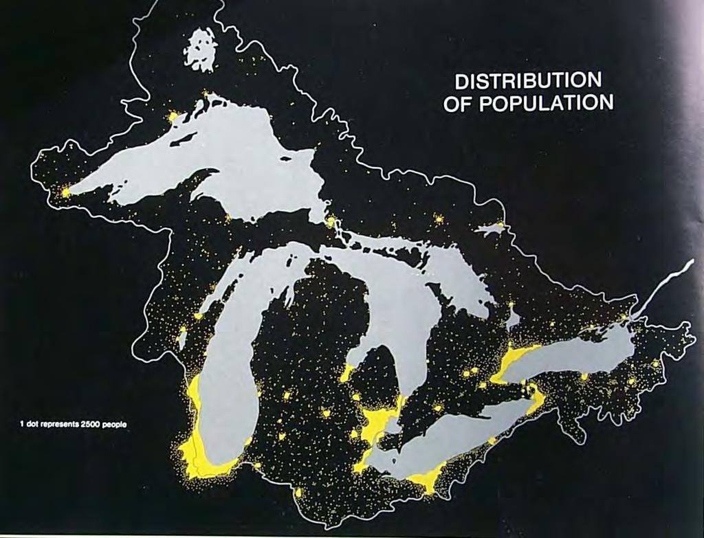
1 Natural history of coastal wetlands in the greater Chequamegon Bay region Kakagon Sloughs, Bad River Reservation 1980s Jim Meeker, Northland College


2 small large northern Great Lake wetlands are dominated by peatlands with fewer marshes, compared to the lower Great Lakes old new
3
4 General location of lake-connected coastal wetlands relative to degree of protection and isostatic rebound

5 Isostatic rebound The lake s outlet is rebounding faster Than this end

6 What was the pre-settlement vegetation in these areas?
7 We come to a bay 25 miles around (Chequamegon Bay). In it there is a channel where we take a great store of fish: sturgeons of vast bigness and pike seven feet long. At the end of the bay we land. Pierre Esprit Radisson 1658


8 shore fen Sphagnum lawn Sedge meadow Different from inland peatland types (e.g. Honest John Lake) Tamarack swamp


9 Big Change!! Duluth Harbor Today Duluth Harbor ca 1870 Peatlands

10 Cedar swamps The forest sponge

11 Coastal Peatlands in flux - 1 Altered shore fens, Allouez Bay, WI. half way in the Peatland to Marsh Transition Degraded Peatland Added sediment Developing Marshes

12 Coastal Peatlands in flux -2 Beginning Nutrient enrichment of shore fens (Port Wing, WI)
13 The Only Constant is Change With or without humans, natural systems are dynamic, that is, they change from one state to another. How does one separate natural change from human-caused or anthropogenic change? Or can we do this?
14 Water/Hydrology is the key Quantity and timing of water Changes occur: - Daily tides, seiches, wind, waves - Annually timing of peaks (early or late summer) Year to year fluctuations e.g high water Longer term changes relative to isostatic rebound /stream capture

15 1986 to to 2002 Hydrological pulses in Lake Superior

16 Classic zonation w/ drawdown Northern sedge meadow Mud flat annuals
17 High water year Wild-rice response to a drawdown 1)migration into channel 2)approximate 40% increase in stem density Low water year
 Bogs between the ridges (Approx.")
18 Long Island/ Chequamegon Point Panne (damp sand) (30 yrs) Developing sedge meadow (30-50 yrs) Bogs between the ridges (Approx yrs) Interdunal pools (>50 <100 yrs)
19 Developing sedge meadow Increasers (29%) blue joint grass (C. canadensis) +186% (8%) tussock sedge (Carex stricta) +128% (4%) woolgrass (Scirpus cyperinus) +76% (2%) swamp candles (Lysimachia terrestris) + 43% Decreasers (23%) wiregrass (Carex lasiocarpa) -81% (14%) bladderwort (Utricularia intermedia) -100% (2%) baltic rush (Juncus articus) -57%
 wide-lvd cattail (Typha latifolia) +272% Interdunal Pond Decreasers: (9%) hard stemmed bulrush (Scirpus acutus) 87% (3%) Naiad (Najas flexilis)")
20 Increasers: (45%) wiregrass sedge (Carex lasiocarpa) +58% (15%) bladderwort (Utricularia intermedia) +110% (13%) beaked sedge (Carex utricularia) +800% (10%) wide-lvd cattail (Typha latifolia) +272% Interdunal Pond Decreasers: (9%) hard stemmed bulrush (Scirpus acutus) 87% (3%) Naiad (Najas flexilis) -100%
 + 47% Bog Swale Neutral: (51%) Sphagnum spp. +1% Decreasers: (2%) wide lvd. cattail (T. latifolia) - 77% (1.")
21 Increasers: (33%) leatherleaf (C. calyculata) +38% (4%) sweet gale (Myrica gale) + 21% (3%) tag alder (Alnus incana) +89% (2%) cranberry (Vaccinium spp.) + 47% Bog Swale Neutral: (51%) Sphagnum spp. +1% Decreasers: (2%) wide lvd. cattail (T. latifolia) - 77% (1.5%) water-arum (Calla palustris) 75% (1%) cotton grass (Eriophorum sp.) -100%
22 The ultimate question is which changes are directional and which are cyclic? We are now able to predict how these wetland communities might change the next time they experience significant high water, that is, if they are following a cyclic pattern, or a directional change like the peatland to marsh process we have seen in many other systems. Need high water again!!!!!

23 Rogue s Gallery of Invaders Purple loosestrife n. l. cattail Common reed Reed canary

24 Narrow vs. Wide Leaf Typha
25 Kakagon Sloughs Drowned Delta
26 Monitoring included: 1) Assessing vegetation in quadrats (1 m 2) along two types of transects 2) delineating clone size (for narrow leaf/hybrid cat-tail only) Tangential transect Perpendicular transect
27 Changes in cattail abundance wide vs. narrow lf (& hybrid) % Frequency Stem Density Wide leaf Narrow Lf. (perp.) Narrow lf. (tang.)
28 Bad River entering into Lake Superior and spilling into Bad River sloughs after a rain event

29 Steam Capture ca 750 yrs ago Catastrophic Change White R. Bad R.

30 Newer peatland Older peatland Old White R. channel
31 Bad River fluvial dynamics Former White River channel
32 Bad River sediment supply, today it transports the sediment from both the Bad and the White Rivers Long Island recurved spit Oak (Brush) Point recurved spit Added sediment from the capture of the White River added enough extra sediment to build Chequamegon Point
33 All dates older than Long Island 760 +/- 50 BP 710 +/- 60 BP /- 50 BP Former White River Channel
34 Summary So. In the light of all this change ( natural, anthropogenic), Which wetlands do we have the best chance of holding on to pre-settlement conditions the longest? Stockton Island, Apostle Islands National Park E. Epstein photo


35 Much more to explore - Questions??
36 Honest John Lake
Ms. A. Mormando's Class *
 8 th Grade Science Essential Standard: 8.E.1.1 Explain the structure of the hydrosphere including: Water distribution on Earth; Local river basin and water availability Stream - A stream is a body of water
Taunton River Salt Marsh Assessment Results from 2014 season
 Taunton River Salt Marsh Assessment Results from 2014 season December, 2014 During the late summer and fall of 2014, Save The Bay evaluated salt marshes in Assonet Bay, Freetown and Broad Cove in Dighton
2017 Aquatic Plant Survey: Silver Lake (WBIC# )
") Aquatic Plants in Silver Lake; Hennepin County, MN August 07 577 Creekside Lane Osseo, MN 5569 james@freshwatersci.com (65) 6-8696 07 Aquatic Plant Survey: Silver Lake (WBIC# 7-06-00) Surveyed August,
Aquatic Plants in Silver Lake; Hennepin County, MN August 07 577 Creekside Lane Osseo, MN 5569 james@freshwatersci.com (65) 6-8696 07 Aquatic Plant Survey: Silver Lake (WBIC# 7-06-00) Surveyed August,
Geol 117 Lecture 18 Beaches & Coastlines. I. Types of Coastlines A. Definition:
 I. Types of Coastlines A. Definition: 1. Shore = narrow zone where ocean meets land (e.g. beach) 2. Coast is a broad area where both ocean and land processes act a. Includes onshore marshes, dunes, sea
7.3 Paleoenvironmental History of Jamaica Bay Marshes, New York
 7.3 Paleoenvironmental History of Jamaica Bay Marshes, New York Dorothy Peteet and Louisa Lieberman 7.3.1 INTRODUCTION Jamaica Bay Wildlife Refuge, a U.S. National Park, is internationally and nationally
Quantifying effects of oil on coastal dune vegetation. Thomas Miller and Elise Gornish Biological Science, Florida State University
 Quantifying effects of oil on coastal dune vegetation Thomas Miller and Elise Gornish Biological Science, Florida State University Natural History of Barrier Islands in the Northern Gulf Make up ~70% of
Learning Objectives: I can identify and interpret river flows and directions.
 Learning Objectives: I can identify and interpret river flows and directions. Bellringer Review: Check for Understanding Questions: 1 2 What Are The Key Parts Of A River s Anatomy? In your data notebooks
Great Lakes Coastal Wetlands Classification First Revision (July 2003)
") Great Lakes Coastal Wetlands Classification First Revision (July 2003) D. A. Albert, J. Ingram, T. Thompson, D. Wilcox, on behalf of the Great Lakes Coastal Wetland Consortium (GLCWC) Great Lakes coastal
Great Lakes Coastal Wetlands Classification First Revision (July 2003) D. A. Albert, J. Ingram, T. Thompson, D. Wilcox, on behalf of the Great Lakes Coastal Wetland Consortium (GLCWC) Great Lakes coastal
Diagnostic Geomorphic Methods for Understanding Future Behavior of Lake Superior Streams What Have We Learned in Two Decades?
 Diagnostic Geomorphic Methods for Understanding Future Behavior of Lake Superior Streams What Have We Learned in Two Decades? Faith Fitzpatrick USGS WI Water Science Center, Middleton, WI fafitzpa@usgs.gov
Purple Loosestrife Project Biocontrol Sites:
 Purple Loosestrife Project Biocontrol Sites: Interim results of a cooperative project between Michigan State University and Michigan Sea Grant Extension Photos, Maps and Layout by Jason K. Potter 2002
Types of Wetlands. Tidal Systems
 Types of Wetlands Tidal Systems 1 COASTAL WETLAND ECOSYSTEMS Tidal Salt Marshes Tidal Freshwater Marshes Mangrove Wetlands 2 Tidal Estuarine Wetland 3 Definition and Formation of Estuaries Estuary: : partially
Subtidal permanently flooded with tidal water. Irregularly exposed surface exposed by tides less often than daily
 Types of Wetlands Tidal Systems COASTAL WETLAND ECOSYSTEMS Tidal Salt Marshes Tidal Freshwater Marshes Mangrove Wetlands Tidal Estuarine Wetland 1 Definition and Formation of Estuaries u Estuary : partially
Plate 27.-Two habitats are shown here. Classification of nonvegetated zone: SYSTEM Riverine, SUBSYSTEM Tidal, CLASS Unconsolidated
 72 Plate 27.-Two habitats are shown here. Classification of nonvegetated zone: SYSTEM Riverine, SUBSYSTEM Tidal, CLASS Unconsolidated Shore, SUBCLASS Mud, WATER REGIME Regularly Flooded, WATER CHEMISTRY
Developed in Consultation with Florida Educators
 Developed in Consultation with Florida Educators Table of Contents Next Generation Sunshine State Standards Correlation Chart... 7 Benchmarks Chapter 1 The Practice of Science...................... 11
THE DELINEATION OF WETLANDS IN THE WQODHAVEN VILLAGE DEVELOPMENT THE OLD BRIDGE PLANNING BOARD
 A" oii CA002364E REPORT ON THE DELINEATION OF WETLANDS IN THE WQODHAVEN VILLAGE DEVELOPMENT AREA Presented to: THE OLD BRIDGE PLANNING BOARD Presented by: Norbert P. Psuty Charles T. Roman MAY 13, 1986
Lake Vermilion ( ) Aquatic Vegetation Survey
 Aquatic Vegetation Survey") Lake Vermilion (69-0378 - 00) Aquatic Vegetation Survey 22796 County Highway 6 Detroit Lakes, MN 56501 (218) 846-1465 www.rmbel.info Table of Contents Executive Summary... 3 Introduction... 4 Methods...
Lake Vermilion (69-0378 - 00) Aquatic Vegetation Survey 22796 County Highway 6 Detroit Lakes, MN 56501 (218) 846-1465 www.rmbel.info Table of Contents Executive Summary... 3 Introduction... 4 Methods...
Lab 2 The reinvasion of flowering plants into aquatic habitats
 Lab 2 The reinvasion of flowering plants into aquatic habitats BIOL 3601: PLANT DIVERSITY Lab Goals: To learn about adaptations of aquatic plants in different aquatic zones To learn common aquatic plants
TEST NAME: Biome Test 10/7 TEST ID: GRADE:05 - Fifth Grade SUBJECT:Life and Physical Sciences TEST CATEGORY: My Classroom
 TEST NAME: Biome Test 10/7 TEST ID:1239163 GRADE:05 - Fifth Grade SUBJECT:Life and Physical Sciences TEST CATEGORY: My Classroom Biome Test 10/7 Page 1 of 8 10/07/16, Biome Test 10/7 Student: Class: Date:
4.2 Tidal Wetlands. Phragmites Australis
 4.2 Tidal Wetlands Few topics elicit such strong emotions in Guilford as the current state of salt marshes. These marshes, more broadly known as tidal wetlands, are undergoing a transformation as sea level
Coastal Tidal Marshes
 Virginia s Wetlands Coastal Tidal Marshes Hydrology driven by lunar tides; Stresses include tidal inundation and/or salts; Found along high latitudes along intertidal coasts; Comprise ~ 70% wetlands of
2.2.7 Backbarrier flats
 FIGURE 24. VERTICAL PHOTOGRAPH SHOWING THE DEVELOPMENT OF SMALL PARABOLIC DUNES FROM BLOWOUTS IN A LARGE RELICT FOREDUNE NORTHWEST OF HUNTER'S CREEK. PHOTOGRAPH COURTESY OF CAR'T'ER HOLT HARVEY FORESTS
How Do Human Impacts and Geomorphological Responses Vary with Spatial Scale in the Streams and Rivers of the Illinois Basin?
 How Do Human Impacts and Geomorphological Responses Vary with Spatial Scale in the Streams and Rivers of the Illinois Basin? Bruce Rhoads Department of Geography University of Illinois at Urbana-Champaign
MEMORANDUM FOR SWG
 MEMORANDUM FOR SWG-2007-1623 Subject: Jurisdictional Determination (JD) for SWG-2007-1623 on Interdunal Wetlands Adjacent to Traditional Navigable Waters (TNWs) Summary The U.S. Environmental Protection
CHAPTER 6 & 7 VOCABULARY
 CHAPTER 6 & 7 VOCABULARY 1. Biome 2. Climate 3. Latitude 4. Altitude 5. Emergent layer 6. Epiphyte 7. Understory 8. Permafrost 9. Wetland 10.Plankton 11.Nekton 12.Benthos 13.Littoral zone 14.Benthic zone
Background information of groundwater dependent ecosystems (GDE) on Estonian Gauja-Koiva river basin
 on Estonian Gauja-Koiva river basin") Background information of groundwater dependent ecosystems (GDE) on Estonian Gauja-Koiva river basin Elve Lode & Martin Küttim Content Some facts about the Koiva river Something about GDEs Ecological data
Background information of groundwater dependent ecosystems (GDE) on Estonian Gauja-Koiva river basin Elve Lode & Martin Küttim Content Some facts about the Koiva river Something about GDEs Ecological data
Environmental Science
 Environmental Science A Study of Interrelationships Cui Jiansheng Hebei University of Science and Technology CH06 Kinds of Ecosystems and Communities Chapter Objectives After reading this chapter, you
South Carolina Coastal Habitats
 South Carolina Coastal Habitats By C. Livingston, 2009 Earth Where is South Carolina? North America United States of America SC Here we are! South Carolina borders the Atlantic Ocean. Did you know? South
Using core samples from lakes to understand past ecological changes and the impacts of land use: manoomin project
 Using core samples from lakes to understand past ecological changes and the impacts of land use: manoomin project Amy Myrbo LacCore/Limnological Research Center University of Minnesota, Minneapolis Lakes
Coastal Ecosystems: Salt Marshes and Mangroves. Marine Biology Dr. Ouida Meier
 Coastal Ecosystems: Salt Marshes and Mangroves Marine Biology Dr. Ouida Meier Factors Driving Coastal Ecosystems Latitude temperature light, seasonality Tidal cycles amplitude frequency Wave energy Degree
Supplemental Slides. Shore: Junction of Land & Water. Junction of Land & Water. Sea Level Variations. Shore vs. Coast. Sea Level Variations
 Shore: Junction of Land & Water Supplemental Slides Sediments come off land Most get dumped at the beach Sediment interacts with ocean waves and currents Junction of Land & Water Features: Breaking waves,
Shore: Junction of Land & Water. Sediments come off land Most get dumped at the beach Sediment interacts with ocean waves and currents
 Shore: Junction of Land & Water Supplemental Slides Sediments come off land Most get dumped at the beach Sediment interacts with ocean waves and currents Junction of Land & Water Features: Breaking waves,
Stephen J. Souza, Ph.D. Princeton Hydro, LLC
 Stephen J. Souza, Ph.D. Princeton Hydro, LLC SSouza@PrincetonHydro.com Project Overview Project Team Princeton Hydro, LLC Simone & Collins, LA Aquetong Creek a first & second order stream - Ingham Spring
Field Guide. To The Aquatic Plants of. Cobbett s Pond. May Improvement Association. Prepared for: Prepared by:
 To The Aquatic Plants of Cobbett s Pond May 2010 Prepared for: Cobbett s Pond Improvement Association Prepared by: 289 Great Rd., Acton, MA 01720 (978) 263-9588 This to the Aquatic Plants of Cobbett s
Ecological Patterns and Processes in Ghost Tree Islands of the Everglades
 Ecological Patterns and Processes in Ghost Tree Islands of the Everglades Sharon M. L. Ewe 1, Binhe Gu 2, Jennifer Vega 1 and Kristin Vaughan 1 1 Ecology and Environment Inc., 12300 South Shore Blvd, Wellington,
Big Red Fish / Walton
 Aquatic plant data collected on July 26, 2000 Big Red Fish / Walton Percent area covered with aquatic vegetation (PAC, %). Percent of lake's volume filled with vegetation (PVI, %). Average emergent plant
Elkhorn Slough Marsh Stratigraphy
 Elkhorn Slough Marsh Stratigraphy Prehistoric marsh extent & recent sediment accretion Elizabeth Burke Watson, Ph.D. U.S. Environmental Protection Agency Narragansett, RI Paleoecology: Reconstruction of
What is a landform? These shapes (except for bodies of water) on the earth s surface are all examples of landforms.
 on the earth s surface are all examples of landforms.") Landforms What is a landform? These shapes (except for bodies of water) on the earth s surface are all examples of landforms. archipelago a large group of many islands. The Hawaiian Islands Lighthouse
Landforms What is a landform? These shapes (except for bodies of water) on the earth s surface are all examples of landforms. archipelago a large group of many islands. The Hawaiian Islands Lighthouse
Lake-Level Variability and Water Availability in the Great Lakes
 National Water Availability and Use Program Lake-Level Variability and Water Availability in the Great Lakes Circular 1311 U.S. Department of the Interior U.S. Geological Survey Front-cover photo: Drowned-river-mouth
Overview of Methods. Terrestrial areas that are most important for conservation Conservation
 Overview of Methods The goal of the Western Lake Erie Coastal Conservation Vision project (WLECCV) is to define where we should be working locally to optimally achieve regional conservation impact. The
Steven Noble MDEQ - WRD Enbridge Response Unit
 EPA situation report, October 19, 2012 Steven Noble MDEQ - WRD Enbridge Response Unit Brief history of the spill Monitoring Monitoring the impacts Follow the oil The Current Situation A Look at the Future
HISTORICAL DELTA LANDSCAPES Conceptual models for building a diverse and resilient future
 HISTORICAL DELTA LANDSCAPES ITEM REMOVED DUE TO COPYRIGHT STATUS Conceptual models for building a diverse and resilient future Robin Grossinger and Alison Whipple San Francisco Estuary Institute/Aquatic
Briggs Lake Water Quality Report 2014
 Briggs Lake Water Quality Report 2014 Seasonal Report for Briggs Lake Green Oak Township, Livingston Co. T1N, R6E, Sec. 3,4 74 Surface Acres 414 Hadley Street Holly, MI 48442 Main Phone: 248-634-8388 Northern
Overview of fluvial and geotechnical processes for TMDL assessment
 Overview of fluvial and geotechnical processes for TMDL assessment Christian F Lenhart, Assistant Prof, MSU Research Assoc., U of M Biosystems Engineering Fluvial processes in a glaciated landscape Martin
Catastrophic Events Impact on Ecosystems
 Catastrophic Events Impact on Ecosystems Hurricanes Hurricanes An intense, rotating oceanic weather system with sustained winds of at least 74 mph and a welldefined eye Conditions for formation: Warm water
Island Design. UMRS EMP Regional Workshop. Presentation for the
 Island Design Presentation for the UMRS EMP Regional Workshop by Jon Hendrickson Hydraulic Engineer Regional Technical Specialist, Water Quality and Habitat Restoration August 17 19, 2005 Project Delivery
Vegetation and Terrestrial Wildlife
 Vegetation and Terrestrial Wildlife Vegetation Plant Communities Disturbance Unique Communities Wildlife Amphibians and Reptiles Birds Mammals Terrestrial Ecology: Vegetation Goals of vegetation sampling
W he natural resources of Adams
 Above: Houghton Rock, Town of Adams. Following Page: "The Hole in the Rock" on Rattlesnake Mound--both remnants of rock formed by ancient seas hundreds of millions of year5 ago. (Courtesy, H.H. Bennett
FIELD GUIDE BOREAL WETLAND CLASSES IN THE BOREAL PLAINS ECOZONE OF CANADA
 FIELD GUIDE BOREAL WETLAND CLASSES IN THE BOREAL PLAINS ECOZONE OF CANADA FIRST EDITION VERSION 1.1 JANUARY 2015 VERSION 1.1 ISBN 978-0-9812303-2-0 January 2015 FIELD GUIDE BOREAL WETLAND CLASSES IN THE
Criteria for delineating a new boundary for the Fisher Bay Park Reserve, Manitoba
 1 Criteria for delineating a new boundary for the Fisher Bay Park Reserve, Manitoba R. A. Lastra Department of Botany, University of Manitoba, Winnipeg, MB, Canada, R3T 2N2 1. INTRODUCTION Historic park
A hydrological study of Waen y Griafolen blanket bog, North Wales
 A hydrological study of Waen y Griafolen blanket bog, North Wales GRAHAM HALL, ROGER CRATCHLEY & SARAH JOHNSON Centre for Arid Zone Studies, School of Agricultural and Forest Sciences, University of Wales,
Prepared by the North American Ice Service. 4 December Seasonal Outlook Great Lakes Winter
 Prepared by the North American Ice Service A collaboration of the Canadian Ice Service and the National/Naval Ice Center 4 December 2008 Seasonal Outlook Great Lakes Winter 2008-2009 - 1 - Table of contents
Aquatic Plant Community of the Red Cedar Lakes
 2011, Freshwater Scientific Services, LLC Page 1 of 69. Aquatic Plant Community of the Red Cedar Lakes, July/Aug 2011 www.fixmylake.com 18029 83 rd Avenue North Maple Grove, MN 55311 mail@freshwatersci.com
Chapter 6, Part Colonizers arriving in North America found extremely landscapes. It looked different to region showing great.
 Social Studies 9 Unit 1 Worksheet Chapter 6, Part 1. 1. Colonizers arriving in North America found extremely landscapes. It looked different to region showing great. 2. The Earth is years old and is composed
Shoreline Protection by Native Vegetation
 Shoreline Protection by Native Vegetation Native Vegetation listed in this presentation protect both the shoreline and the water beyond. Various mixtures of these native species provide a filter that interrupts
Module 3. Basic Ecological Principles
 Module 3. Basic Ecological Principles Ecosystem Components Abiotic Biotic Species & Habitat The Biomes of North America Communities Energy & Matter Cycles in Ecosystems Primary Productivity Simple Ecosystem
The Geology of Sebago Lake State Park
 Maine Geologic Facts and Localities September, 2002 43 55 17.46 N, 70 34 13.07 W Text by Robert Johnston, Department of Agriculture, Conservation & Forestry 1 Map by Robert Johnston Introduction Sebago
The Coast: Beaches and Shoreline Processes
 1 2 3 4 5 6 7 8 9 The Coast: es and Shoreline Processes Trujillo & Thurman, Chapter 10 Oceanography 101 Chapter Objectives Recognize the various landforms characteristic of beaches and coastal regions.
The Coast: Beaches and Shoreline Processes Trujillo & Thurman, Chapter 10
 The Coast: es and Shoreline Processes Trujillo & Thurman, Chapter 10 Oceanography 101 Chapter Objectives Recognize the various landforms characteristic of beaches and coastal regions. Identify seasonal
BIOSPHERE. Vegetation plant succession Psammoseres sand dune successions
 Vegetation plant succession Psammoseres sand dune successions 1 What do you need to know? Evolution of vegetation communities to climax states Example: Coastal dune belts 2/3 examples of plants and their
Australian Coastal Councils Conference
 Australian Coastal Councils Conference 11 March 2015 Estimating Future Coastal Inundation and Erosion Hazards Dr Andrew McCowan Dr Christine Lauchlan-Arrowsmith Warwick Bishop Background Victorian Future
STUDY GUIDE FOR CONTENT MASTERY. Surface Water Movement
 Surface Water SECTION 9.1 Surface Water Movement In your textbook, read about surface water and the way in which it moves sediment. Complete each statement. 1. An excessive amount of water flowing downslope
Woodstock, Route 26 Stream Relocation Project
 MAINE DEPARTMENT OF TRANSPORTATION 2006 POST - CONSTRUCTION MONITORING REPORT: Woodstock, Route 26 Stream Relocation Project Year 1 of 5 Compensation for the Woodstock, Route 26 Highway Reconstruction
Abiotic Dominant Dominant Factors Plants Animals
 TERRESTRIAL BIOMES Abiotic Dominant Dominant Factors Plants Animals Tropical Rain Forest Hot & wet year round Ferns Woody vines Broad leaved evergreen trees Sloths Jaguars Monkeys Toucans Tropical Dry
How does erosion happen?
 How does erosion happen? By National Geographic, adapted by Newsela staff on 10.03.17 Word Count 682 Level 830L These rock formations, in Bryce Canyon National Park, Utah, are called hoodoos. Although
Long-Term Patterns of Coastal Response to Changing Land Use and Climate: Examples from the Atlantic and Gulf Coastal Plains
 Long-Term Patterns of Coastal Response to Changing Land Use and Climate: Examples from the Atlantic and Gulf Coastal Plains Debra Willard, Christopher Bernhardt, and Miriam Jones U.S. Geological Survey,
Carbon Assimilation and Its Variation among Plant Communities
 Carbon Assimilation and Its Variation among Plant Communities Introduction By, Susan Boersma, Andrew Wiersma Institution: Calvin College Faculty Advisor: David Dornbos Currently, global warming remains
Moosehead Lake and the Tale of Two Rivers
 Maine Geologic Facts and Localities June, 2005 45 o 53 5.09 N, 69 o 42 14.54 W Text by Kelley, A.R.; Kelley, J.T.; Belknap, D.F.; and Gontz, A.M. Department of Earth Sciences, University of Maine, Orono,
Descriptions and Performance
 LSU AgCenter Coastal Plants Program Smooth Cordgrass Varieties: Descriptions and Performance Smooth cordgrass (Spartina alterniflora Loisel.) is a perennial grass native to intertidal saline marshes along
Coastal Processes 101. Greg Berman (Woods Hole Sea Grant & Cape Cod Cooperative Extension)
") Coastal Processes 101 Greg Berman (Woods Hole Sea Grant & Cape Cod Cooperative Extension) January 23, 2019 Coastal Processes 101 Outline: ~30 min talk Coastal Processes What is Erosion? Value of the Ecosystem
Coastal Processes 101 Greg Berman (Woods Hole Sea Grant & Cape Cod Cooperative Extension) January 23, 2019 Coastal Processes 101 Outline: ~30 min talk Coastal Processes What is Erosion? Value of the Ecosystem
What is a landform? These shapes (except for bodies of water) on the earth s surface are all examples of landforms.
 on the earth s surface are all examples of landforms.") Landforms What is a landform? These shapes (except for bodies of water) on the earth s surface are all examples of landforms. archipelago a large group of many islands. The Hawaiian Islands Lighthouse
Landforms What is a landform? These shapes (except for bodies of water) on the earth s surface are all examples of landforms. archipelago a large group of many islands. The Hawaiian Islands Lighthouse
George Host and Tom Hollenhorst Natural Resources Research Institute University of Minnesota Duluth
 George Host and Tom Hollenhorst Natural Resources Research Institute University of Minnesota Duluth Marc Hershfield Minnesota Pollution Control Agency Duluth, MN St. Louis River watershed Duluth-Superior
Coastal Processes 101 & The Regs. Greg Berman (Woods Hole Sea Grant & Cape Cod Cooperative Extension)
") Coastal Processes 101 & The Regs Greg Berman (Woods Hole Sea Grant & Cape Cod Cooperative Extension) March 26, 2019 Coastal Processes 101 & The Regs Outline: ~15 min talk Coastal Processes What is Erosion?
Coastal Processes 101 & The Regs Greg Berman (Woods Hole Sea Grant & Cape Cod Cooperative Extension) March 26, 2019 Coastal Processes 101 & The Regs Outline: ~15 min talk Coastal Processes What is Erosion?
The River Restoration Centre therrc.co.uk. Understanding Fluvial Processes: supporting River Restoration. Dr Jenny Mant
 The River Restoration Centre therrc.co.uk Understanding Fluvial Processes: supporting River Restoration Dr Jenny Mant Jenny@therrc.co.uk Understanding your catchment Hydrology Energy associated with the
Moreton Bay and Key Geographic Concepts Worksheet
 Moreton Bay and Key Geographic Concepts Worksheet The Australian Curriculum: Geography draws on seven key geographic concepts: place scale space environment change interconnection sustainability They are
Aquatic Plant Survey Methods
 Aquatic Plant Survey Methods Field Methods Harmony Environmental employed a point intercept method for the macrophyte sampling. The Wisconsin Department of Natural Resources (Wisconsin DNR) generated the
Northern Bog Aster. Summary. Protection Threatened in New York State, not listed federally.
 Northern Bog Aster Symphyotrichum boreale Scientific Name Family Name Symphyotrichum boreale (Torr. & Gray) A. & D. Löve Asteraceae Aster Family Photo credits: Robert H. Mohlenbrock. USDA SCS. 1989; downloaded
Changes to Land 5.7B. landforms: features on the surface of Earth such as mountains, hills, dunes, oceans and rivers
 All the landforms on Earth have changed over time and continue to change. Many of the changes were caused by wind, moving water, and moving ice. Mountains have grown and shrunk. Rivers have cut away land
Sediment Management in the Coastal Bays
 Sediment Management in the Coastal Bays Introduction Need for ecosystem view of sediment management in Coastal Bays Island loss and restoration Navigation needs Habitat Trade offs Living Shoreline Requirements
Ecological Succession
 Ecological Succession Primary succession will ALWAYS be on areas where there is NO SOIL a) bare rock from a retreating glacier, b) newly cooled lava; c) abandoned lot with an impervious surface (parking
Biomes of the World What is a Biome?
 Biomes of the World What is a Biome? A large, relatively distinct terrestrial region with characteristic Climate Soil Plants Animals Interacting landscapes 1 Terrestrial Biomes Using Precipitation And
Think about the landforms where you live. How do you think they have changed over time? How do you think they will change in the future?
 reflect All the landforms on Earth have changed over time and continue to change. Many of the changes were caused by wind, moving water, and moving ice. Mountains have grown and shrunk. Rivers have cut
Changes in Texas Ecoregions
 Comment On Lesson Changes in Texas Ecoregions The state of Texas can be divided into 10 distinct areas based on unique combinations of vegetation, topography, landforms, wildlife, soil, rock, climate,
EQ: Discuss main geographic landforms of the U.S. & Canada and examine varied landforms in relation to their lifestyles.
 EQ: Discuss main geographic landforms of the U.S. & Canada and examine varied landforms in relation to their lifestyles. Places & Terms for Discussion Appalachian Mountains Great Plains Canadian Shield
Coastal issues: Beaches and Estuaries
 Coastal issues: Beaches and Estuaries Definitions: Coast = broad zone where both marine & terrestrial processes act It includes the beach, lagoons, marshes, bars etc. Coastal processes act to shape the
Wetlands in a Watershed/Landscape Context Vegetation & Wildlife August 15, Kendra Moseley, Regional ESS, Soil Science Division
 Wetlands in a Watershed/Landscape Context Vegetation & Wildlife August 15, 2018 - Kendra Moseley, Regional ESS, Soil Science Division Vegetation in Wetlands Vegetation as an Indicator of Hydrology Vegetation
e Southeast Region of the United Statesg
 e Southeast of the United Statesg - relative location: the location of a place in relation to another place (i.e. south, near, bordering, next to) - barrier islands: located off the southeast coast of
Tony Pratt, DNREC to The Center for the Inland Bays Scientific and Technical Advisory Committee. August 21, 2009
 Sea Level Rise in Delaware Presented by Tony Pratt, DNREC to The Center for the Inland Bays Scientific and Technical Advisory Committee August 21, 2009 Sea level has been fluctuating ever since there have
Human Impacts to Rivers
 Human Impacts to Rivers Sediment Water Wood Confinement Valley slope Channel morphology Bank material Flow obstructions Riparian vegetation Human Impacts on Rivers dams channelization loss of woody debris/riparian
Carbon Sequestration Potential from Coastal Wetlands Restoration Sites
 Carbon Sequestration Potential from Coastal Wetlands Restoration Sites Insert then choose Picture select your picture. Right click your picture and Send to back. Paul Krause, Alyssa Beach Emily Cooper,
Protecting the Storm Damage Prevention and Flood Control Interests of Coastal Resource Areas
 Protecting the Storm Damage Prevention and Flood Control Interests of Coastal Resource Areas Presented by: Massachusetts Department of Environmental Protection & Massachusetts Office of Coastal Zone Management
Wetland & Floodplain Functional Assessments and Mapping To Protect and Restore Riverine Systems in Vermont. Mike Kline and Laura Lapierre Vermont DEC
 Wetland & Floodplain Functional Assessments and Mapping To Protect and Restore Riverine Systems in Vermont Mike Kline and Laura Lapierre Vermont DEC NWI+ Hydro-Geomorphic Characterization of Wetlands and
Flowering Rush (Butomus umbellatus) in Flathead Lake and River: An Integrated Invasive Plant Management Project
 in Flathead Lake and River: An Integrated Invasive Plant Management Project") Flowering Rush (Butomus umbellatus) in Flathead Lake and River: An Integrated Invasive Plant Management Project Mara Johnson, Center for Invasive Plant Management; Peter Rice, University of Montana; Virgil
Flowering Rush (Butomus umbellatus) in Flathead Lake and River: An Integrated Invasive Plant Management Project Mara Johnson, Center for Invasive Plant Management; Peter Rice, University of Montana; Virgil
Wetland attenuation of Hurricane Rita s storm surge
 Wetland attenuation of Hurricane Rita s storm surge Pat Fitzpatrick, Yee Lau, Yongzuo Li, Nam Tran, Chris Hill, and Suzanne Shean Geosystems Research Institute, Mississippi State University Sponsors: NOAA
Lab 12 Coastal Geology
 Lab 12 Coastal Geology I. Fluvial Systems Hydrologic Cycle Runoff that flows into rivers = precipitation (rain and snowmelt) [infiltration (loss to groundwater) + evaporation (loss to atmosphere) + transpiration
Natural Shoreline Landscapes on Michigan Inland Lakes
 Natural Shoreline Landscapes on Michigan Inland Lakes Excerpts from Chapters 2 and 3 Photo Photo by Jane by Jane Herbert Herbert Did you know? Twenty-four species of amphibians, 25 species of reptiles,
Mammoth Cave National Park, Kentucky
 Mammoth Cave National Park, Kentucky Objectives of Today s Lecture Refresher on Sedimentary Depositional Systems and Rock Classifications Transgressive and Regressive Marine Environments Carbonate Depositional
Why Geomorphology for Fish Passage
 Channel Morphology - Stream Crossing Interactions An Overview Michael Love Michael Love & Associates mlove@h2odesigns.com (707) 476-8938 Why Geomorphology for Fish Passage 1. Understand the Scale of the
Smooth Cordgrass Varieties. Description and Performance
 Smooth Cordgrass Varieties Description and Performance Smooth cordgrass (Spartina alterniflora Loisel.) is a perennial grass native to intertidal saline marshes along the Gulf of Mexico and Atlantic coasts.
3.2.2 Ecological units of the Des Quinze lake proposed biodiversity reserve
 3.2.2 Ecological units of the proposed biodiversity reserve An intact forest mass The proposed biodiversity reserve (see appendix 3) protects terrestrial environments almost exclusively. Proximity of Des
netw rks Guided Reading Activity Essential Question: How does geography influence the way people live? Earth's Physical Geography
 Guided Reading Activity Lesson 1 Earth and the Sun Essential Question: How does geography influence the way people live? Looking at Earth Directions: What are the layers that make up Earth? Use your textbook