Critical Coastal Habitat Assessment. Long-term monitoring in Tampa Bay
|
|
|
- Delphia Porter
- 5 years ago
- Views:
Transcription


1 Critical Coastal Habitat Assessment Long-term monitoring in Tampa Bay Kara Radabaugh, Ryan Moyer, Ed Sherwood, Gary Raulerson, Amanda Chappel, Taylor Nielsen, Reba Campbell, and Emma Dontis.
2 Critical Coastal Habitat Assessment (CCHA) CCHA methodology designed for long-term monitoring of coastal habitat response to sea-level rise. Elevation & sediment accretion Flora/fauna species composition Porewater & sediment characteristics Recently completed project baseline Sites to be revisited every 3-5 years

3 Tampa Bay Locations Five sites previously completed by TBEP and Atkins Four additional sites with new EPA funding Instructional manual and video to be released on monitoring methods

4 Site selection Distributed across Tampa Bay Located on conservation land Accessible for monitoring Have a moderate slope that extends through 3-7 zones of vegetation within 200 m

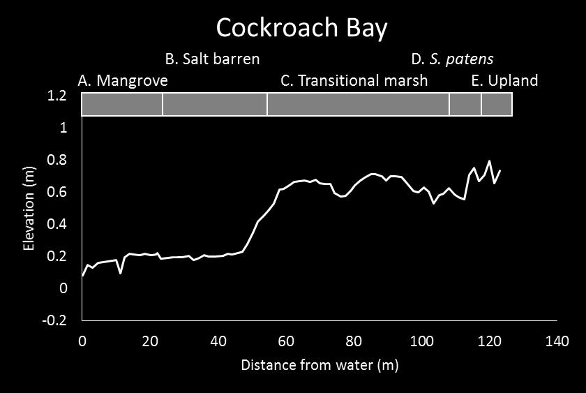
5 Habitat Zonation Transect extends (roughly) perpendicular from water s edge to upland habitat Habitat transitions identified by Shifts in plant species Elevation changes

 using and RTK")

6 Elevation surveys Elevation surveyed every 5 ft (1.5 m) using and RTK GPS. Benchmarks added to beginning and end of transect.


7 Transect sampling 0.5 x 0.5 m quadrat placed along the transect Percent basal cover recorded for all plant species, woody debris, pneumatophores, and macroalgae Photo taken every 2.5 m

8 Sampling design


9 Random plots Vegetation basal % cover Canopy cover canopy densitometer and spherical densiometer Uca sp. burrows Mangrove tree crabs Littorina sp.


 or absolute cover (basal")
10 Point Centered Quarter (PCQ) Measure distance to nearest tree within each of four quarters, record tree diameter and tree height Calculate species-specific density (trees / hectare) or absolute cover (basal area m 2 / hectare)


11 Feldspar horizons Core in 6-12 months, measure millimeters of accretion Does not work in erosional or high-energy environments


12 Porewater and soil Determine porewater salinity and depth Save soil sample of top 5 cm


13 Soil analysis Organic matter content determined by loss on ignition procedures Grain size determined through sieve analysis


14 Sum of % basal cover Veg. Results Transect shows range of each species with respect to elevation and distance from water.
15 Veg. Results PCQ sampling provides metrics of tree abundance and diversity Species-specific density (trees / hectare) Species-specific absolute cover (basal area m 2 / hectare)
16 % organic matter Percent Sediment Majority of sediment fine sand ( µm) Fort de Soto A B C D E F G More organic matter in surface soil of mangroves and upland zones Sediment size fraction Vegetation zone
17 Percent Sediment Majority of sediment fine sand ( µm) Fort de Soto A B C D E F G More organic matter in surface soil of mangroves and upland zones Sediment size fraction
18 Porewater salinity Depth to water (cm) Porewater results Elevation correlated with depth of water table (p<0.0001, r = ) Porewater salinity not correlated with elevation (p = 0.32) Cockroach Bay 30 Fort DeSoto 20 Harbor Palms 10 Weedon Island Elevation (m) Cockroach Bay 60 Fort DeSoto Harbor Palms 50 Weedon Island Elevation (m)
19 Sea-level rise 19 cm avg global SLR since 1901 (IPCC AR5) Low emission scenario (RCP2.6, shown in blue) predicts ~50 cm additional SLR by 2100 (~70 cm total) High emission scenario (RCP8.5, shown in red) predicts ~80 cm additional SLR by 2100 (~1 m total) IPCC AR5 (Church et al. 2013)
 Existing SLR (19 cm) Elevation surveyed using NAVD")
20 High emissions SLR 2100 (1 m) Low emissions SLR 2100 (70 cm) Existing SLR (19 cm) Elevation surveyed using NAVD 88

21 Fort de Soto
22

23 Cockroach Bay

24 High emissions SLR Low emissions SLR Existing SLR


25 Weedon Island
26 High emissions SLR Low emissions SLR

27 Harbor Palms
28 Conclusions Methodology enables long-term study of abiotic conditions and flora/fauna response to sea-level rise. Written and video training manuals SLR scenarios (omitting coastal wetland accretion rates) Low emissions scenario: MSL at elevation of existing salt barrens by 2100 High emissions scenario: MSL at elevation of upland or transitional high marsh by 2100 Landward migration restricted by urban development, roadways, elevation Existing conservation lands with natural buffer vitally important

29 Acknowledgements Funding provided by EPA Regional Wetland Program Development Grant CD-00D Methodology originally developed by Doug Robison, Environmental Science Associates Pamela Latham, Research Planning Inc. Lindsay Cross, Tampa Bay Estuary Program David Loy, Atkins North America Elevation surveys completed by the lab of Dr. Ping Wang, University of South Florida. Field assistance provided by Zachary Westfall, Jun Cheng, Josh Breithaupt, Regi Rodriguez, and Alexis Schefka Land access granted by Pinellas county (Pam Leasure) and Hillsborough County (Mary Barnwell) Church, J.A., P.U. Clark, A. Cazenave, and others 2013: Sea Level Change. In: Climate Change 2013: The Physical Science Basis. Contribution of Working Group I to the Fifth Assessment Report of the Intergovernmental Panel on Climate Change [Stocker, T.F., and others (eds.)]. Cambridge University Press, Cambridge, United Kingdom and New York, NY, USA.
UPDATE ON THE TAMPA BAY CRITICAL COASTAL HABITAT ASSESSMENT
 UPDATE ON THE TAMPA BAY CRITICAL COASTAL HABITAT ASSESSMENT CHIMMP Meeting September 15, 2015 Lindsay Cross, Ed Sherwood Tampa Bay Estuary Program PURPOSE OF PROJECT Develop a long term monitoring program
Section 145 Climate Change and Sea Level Rise
 Section 145 Climate Change and Sea Level Rise A. Definitions Rhode Island Coastal Resources Management Program 1. Climate is the long-term weather average observed within a geographic region, and climate
Sediment Dynamics in Restored Tidal Wetlands of San Francisco Bay
 Sediment Dynamics in Restored Tidal Wetlands of San Francisco Bay John Callaway & Jennifer Gagnon (USF) Lisa Schile (UC Berkeley) Evyan Borgnis & Tom Parker (SFSU) Donna Ball (HT Harvey & Assoc.) Gene
Pablo Bay in Sonoma, Solano, and Napa Counties. It is owned and managed by the U.S. Fish and Wildlife
 Appendix L San Pablo Bay Marsh Introduction San Pablo Bay National Wildlife Refuge marsh (hereafter San Pablo) is located on the north shore of San Pablo Bay in Sonoma, Solano, and Napa Counties. It is
Bob Van Dolah. Marine Resources Research Institute South Carolina Department of Natural Resources
 Bob Van Dolah Marine Resources Research Institute South Carolina Department of Natural Resources Shoreline Change Will Occur! On our front beaches where it is not easy to retreat Shoreline Change Will
Sea Level Rise in Connecticut A Risk-Informed Approach
 GZA GeoEnvironmental, Inc. CAFM Conference October 25, 2017 Proactive By Design. Our Company Commitment Proactive By Design. Our Company Commitment Sea Level Rise in Connecticut A Risk-Informed Approach
9 th INTECOL Orlando, Florida June 7, 2012
 Restoration of the Everglades Saline Wetlands and Florida Bay: Responses Driven from Land and Sea David Rudnick 1, Colin Saunders 2, Carlos Coronado 2, Fred Sklar 2 Erik Stabenau 1, Vic Engel 1, Rene Price
Modeling Sea-Level Rise in Coastal Wetlands: Understanding Potential Impacts and Their Implications for Management on Cape Cod
 Modeling Sea-Level Rise in Coastal Wetlands: Understanding Potential Impacts and Their Implications for Management on Cape Cod C a p e C o a s t a l C o n f e r e n c e H y a n n i s R e s o r t a n d
Types of Wetlands. Tidal Systems
 Types of Wetlands Tidal Systems 1 COASTAL WETLAND ECOSYSTEMS Tidal Salt Marshes Tidal Freshwater Marshes Mangrove Wetlands 2 Tidal Estuarine Wetland 3 Definition and Formation of Estuaries Estuary: : partially
Subtidal permanently flooded with tidal water. Irregularly exposed surface exposed by tides less often than daily
 Types of Wetlands Tidal Systems COASTAL WETLAND ECOSYSTEMS Tidal Salt Marshes Tidal Freshwater Marshes Mangrove Wetlands Tidal Estuarine Wetland 1 Definition and Formation of Estuaries u Estuary : partially
How will mangrove encroachment and eroding impoundments impact coastal protection?
 How will mangrove encroachment and eroding impoundments impact coastal protection? A Case Study in the Merritt Island National Wildlife Refuge Cheryl Doughty 1, Kyle Cavanaugh 1, & Samantha Chapman 2 1
Sea-level Rise on Cape Cod: How Vulnerable Are We? Rob Thieler U.S. Geological Survey Woods Hole, MA
 Sea-level Rise on Cape Cod: How Vulnerable Are We? Rob Thieler U.S. Geological Survey Woods Hole, MA Outline Sea-level and coastal processes Past sea-level change Predictions for the future Coastal responses
The rate and fate of coastal carbon burial
 The rate and fate of coastal carbon burial Matthew L. Kirwan, Virginia Institute of Marine Science Main Points Marsh size Marsh accretion 1. SLR drives wetland carbon burial in vertical and lateral dimensions
CHAPTER 6 & 7 VOCABULARY
 CHAPTER 6 & 7 VOCABULARY 1. Biome 2. Climate 3. Latitude 4. Altitude 5. Emergent layer 6. Epiphyte 7. Understory 8. Permafrost 9. Wetland 10.Plankton 11.Nekton 12.Benthos 13.Littoral zone 14.Benthic zone
Should (R)SET-MH data be used to forecast the effects of sea level rise on wetland resilience and carbon sequestration?
SET-MH data be used to forecast the effects of sea level rise on wetland resilience and carbon sequestration?") Should (R)SET-MH data be used to forecast the effects of sea level rise on wetland resilience and carbon sequestration? Randall W. Parkinson, Ph.D., P.G. Institute for Water and Environment Florida International
Should (R)SET-MH data be used to forecast the effects of sea level rise on wetland resilience and carbon sequestration? Randall W. Parkinson, Ph.D., P.G. Institute for Water and Environment Florida International
SLR: Nuisance flooding patterns along the Coastal Bend
 SLR: Nuisance flooding patterns along the Coastal Bend Philippe Tissot Conrad Blucher Institute Resilient Texas: Planning for Sea Level Rise August 8, 2017 Hurricane Ike - 9/13/2008 Marina Photos Courtesy
Sea Level Rise in Miami-Dade County Florida Implications for Management of Coastal Wetlands and the Everglades
 Sea Level Rise in Miami-Dade County Florida Implications for Management of Coastal Wetlands and the Everglades Peter W. Harlem Dr. John F. Meeder Florida International University Southeast Environmental
Oyster Reef for Shoreline Stabilization and Restoration. Jason Kirkpatrick Conservation Program Manager MacDill AFB Tampa, Florida
 Oyster Reef for Shoreline Stabilization and Restoration Jason Kirkpatrick Conservation Program Manager MacDill AFB Tampa, Florida Interbay Penninsula Port of Tampa X The few remaining mangroves are being
USGS efforts to model sea-level rise impact to tidal marshes along the California coast.
 USGS efforts to model sea-level rise impact to tidal marshes along the California coast. Karen Thorne 1 J.Y Takekawa 1, K. Buffington 1, K. Swanson 2, J. Drexler 2, D.Schoellhamer 2, M. Casazza 3, and
Jun Cheng School of Geosciences, University of South Florida 4202 E. Fowler Ave., NES 117, Tampa, FL 33620
 EDUCATION Jun Cheng 4202 E. Fowler Ave., NES 117, Tampa, FL 33620 Phone: 813-974-2759 Email: jun@mail.usf.ed University of South Florida (Tampa, FL) Ph.D. in Geology, 2015 Dissertation: Multiple Scale
Current and Future Technology Applications for Coastal Zone Management. Bruce K. Carlisle, Acting Director Office of Coastal Zone Management
 Current and Future Technology Applications for Coastal Zone Management Bruce K. Carlisle, Acting Director Office of Coastal Zone Management The Massachusetts Coastal Zone Management Program Approved in
Assessing the Permanence of Blue Carbon Sinks
 Assessing the Permanence of Blue Carbon Sinks with Rising Sea Levels Gail L. Chmura and Dante D. Torio Department of Geography, McGill University and Global Environmental and Climate Change Centre Montreal,
Shoreline and Climate Change Adaptation Alternatives for The Letter Parcel, Bolinas Lagoon
 Shoreline and Climate Change Adaptation Alternatives for The Letter Parcel, Bolinas Lagoon Scenic shoreline vista of Bolinas Lagoon and ridges, from Letter Parcel, March 2016 Peter Baye, Coastal Ecologist
Ecosystem History of Florida Bay and the Southern Estuaries Five Year Update. G. Lynn Wingard (USGS)
") Ecosystem History of Florida Bay and the Southern Estuaries Five Year Update G. Lynn Wingard (USGS) Progress since 2003 Florida Bay Science Conference Expansion of Ecosystem History Research into surrounding
Ecosystem History of Florida Bay and the Southern Estuaries Five Year Update G. Lynn Wingard (USGS) Progress since 2003 Florida Bay Science Conference Expansion of Ecosystem History Research into surrounding
Planning for the Future of Humboldt Bay: Sea Level Rise, Sediment Management, Sand Spits and Salt Marshes. Joel Gerwein
 Planning for the Future of Humboldt Bay: Sea Level Rise, Sediment Management, Sand Spits and Salt Marshes Joel Gerwein Introduction to Humboldt Bay Setting Economy, community, and environment Sediment
4.2 Tidal Wetlands. Phragmites Australis
 4.2 Tidal Wetlands Few topics elicit such strong emotions in Guilford as the current state of salt marshes. These marshes, more broadly known as tidal wetlands, are undergoing a transformation as sea level
Earth s Major Terrerstrial Biomes. *Wetlands (found all over Earth)
") Biomes Biome: the major types of terrestrial ecosystems determined primarily by climate 2 main factors: Depends on ; proximity to ocean; and air and ocean circulation patterns Similar traits of plants
Biomes Biome: the major types of terrestrial ecosystems determined primarily by climate 2 main factors: Depends on ; proximity to ocean; and air and ocean circulation patterns Similar traits of plants
Quality Assurance Project Plan (QAPP) - Vegetation Survey of Huron Creek Houghton, MI
 - Vegetation Survey of Huron Creek Houghton, MI") Quality Assurance Project Plan (QAPP) - Vegetation Survey of Huron Creek Houghton, MI Prepared By: Linda D. Kersten, Dr. Alex S. Mayer Michigan Technological University, Center for Water & Society Prepared
Quality Assurance Project Plan (QAPP) - Vegetation Survey of Huron Creek Houghton, MI Prepared By: Linda D. Kersten, Dr. Alex S. Mayer Michigan Technological University, Center for Water & Society Prepared
Land Use Methods & Metrics Development Outcome
 Quarterly Progress Meeting November 15, 2018 Land Use Methods & Metrics Development Outcome Peter Claggett, USGS LUWG Coordinator Through the Chesapeake Bay Watershed Agreement, the Chesapeake Bay Program
The Use of Geographic Information Systems to Assess Change in Salt Marsh Ecosystems Under Rising Sea Level Scenarios.
 The Use of Geographic Information Systems to Assess Change in Salt Marsh Ecosystems Under Rising Sea Level Scenarios Robert Hancock The ecological challenges presented by global climate change are vast,
Mapping of Future Coastal Hazards. for Southern California. January 7th, David Revell, Ph.D. E.
 Mapping of Future Coastal Hazards for Southern California January 7th, 2014 David Revell, Ph.D. drevell@esassoc.com E. Vandebroek, 2012 Outline Coastal erosion hazard zones Flood hazard zones: Coastal
Appendix F: Projecting Future Sea Level Rise with the SLRRP Model
 Appendix F: Projecting Future Sea Level Rise with the SLRRP Model The Sea Level Rise Rectification Program (SLRRP) is a software package designed with a user-friendly interface to generate a suite of future
Shoreline Mapping & Erosion Patterns. Julia Knisel Julia Knisel Coastal Shoreline & Floodplain Manager
 Shoreline Mapping & Erosion Patterns Along the Massachusetts Coast Julia Knisel Julia Knisel Coastal Shoreline & Floodplain Manager CZM Shoreline Change Project Timeline 1989: produced coast wide maps
Florida Panhandle and Alabama Beaches Welcome Spring Break: Free of Tar Balls at Last
 Florida Panhandle and Alabama Beaches Welcome Spring Break: Free of Tar Balls at Last Ping Wang, James H. Kirby III, and Jun Cheng Coastal Research Laboratory, Department of Geology, University of South
Sediment Management in the Coastal Bays
 Sediment Management in the Coastal Bays Introduction Need for ecosystem view of sediment management in Coastal Bays Island loss and restoration Navigation needs Habitat Trade offs Living Shoreline Requirements
Eco-hydromorphic Characterization of the Louisiana Coastal Region Using Multiple Remotely Sensed Data Sources and Analyses
 National Wetlands Research Center Eco-hydromorphic Characterization of the Louisiana Coastal Region Using Multiple Remotely Sensed Data Sources and Analyses 1Holly Beck, 2 Brady Couvillion, 1 Nadine Trahan
Wetland Sediment Dynamics at Crissy Field Marsh Annual Report
 Wetland Sediment Dynamics at Crissy Field Marsh 27 Annual Report John Callaway Department of Environmental Science University of San Francisco 217 Fulton St. San Francisco, CA 94117 (415) 422-572 callaway@usfca.edu
Sea Level Rise and the Scarborough Marsh Scarborough Land Trust Annual Meeting April 24, 2018
 Sea Level Rise and the Scarborough Marsh Scarborough Land Trust Annual Meeting April 24, 2018 Peter A. Slovinsky, Marine Geologist Maine Geological Survey Funded by: 50% 40% Figure modified from Griggs,
Mussel Powered Living Shorelines for Salt Marsh Erosion Control
 Mussel Powered Living Shorelines for Salt Marsh Erosion Control Laura Whalen Danielle Kreeger David Bushek Angela Padeletti Josh Moody Partnership for the Delaware Estuary Haskin Shellfish Research Lab
Mangrove Restoration and Migration in a Changing Climate: Climatic Drivers and Shifting Ecotones
 Mangrove Restoration and Migration in a Changing Climate: Climatic Drivers and Shifting Ecotones Michael J. Osland & Richard H. Day U.S. Geological Survey, National Wetlands Research Center U.S. Department
Scenarios for the NI coast in the 21 st Century
 Scenarios for the NI coast in the 21 st Century Prof Julian Orford Geography, Archaeology & Palaeoecology Queen s University, Belfast Challenging perspective Living by the coast is good for your health!
Beneficial Reuse of Dredge Material for Salt Marsh Restoration: Early Recovery of Vegetation and Epifaunal Macroinvertebrate
 Metthea Yepsen myepsen@tnc.org Adrianna Zito-Livingston Jessie Buckner Projects funded by New Jersey Department of Environmental Protection and Department of Transportation, The National Fish and Wildlife
Ground Water Control of Tree Island Origin, Genesis and Destruction. By John F. Meeder and Peter W. Harlem SERC,FIU
 Ground Water Control of Tree Island Origin, Genesis and Destruction By John F. Meeder and Peter W. Harlem SERC,FIU Functional Definition Our functional definition of a Tree Island is; an isolated scrub
Factors Governing Successful Tidal Wetland Mitigation. Walter I. Priest, III Wetland Design and Restoration ASWM Webinar 16 July 2018
 Factors Governing Successful Tidal Wetland Mitigation Walter I. Priest, III Wetland Design and Restoration ASWM Webinar 16 July 2018 Goals and Objectives Successful Tidal Wetland Mitigation Primary production
2017 Delaware Estuary Science and Environmental Summit Cape May, NJ January
 2017 Delaware Estuary Science and Environmental Summit Cape May, NJ January 22 25 2017 Beatrice O Hara Dr. Daria Nikitina, Advisor West Chester University of Pennsylvania Department of Earth and Space
Preliminary Results from Coordinated Sea-Level Rise Modeling Using SLAMM, the Sea Level Affecting Marshes Model, Across the US Gulf of Mexico Coast
 Preliminary Results from Coordinated Sea-Level Rise Modeling Using SLAMM, the Sea Level Affecting Marshes Model, Across the US Gulf of Mexico Coast James W. Pahl, Ph.D., and Kristin DeMarco, State of Louisiana
April 9, Phosphate Mining and Reclamation Overview
 April 9, 2012 Phosphate Mining and Reclamation Overview Business & Mission Mosaic produces the majority of the phosphate used by American farmers Employs approximately 7,000 people worldwide, 3,000 in
Considering Nitrogen and Black Mangrove in Context: Lessons Learned
 Considering Nitrogen and Black Mangrove in Context: Lessons Learned Christine N. Pickens 1 Karen L. McKee 2 Mark W. Hester 1 1 Coastal Plant Ecology Laboratory, University of Louisiana at Lafayette 2 US
A Sedimentological and Granulometric Atlas of the Beach Sediments of Florida s Southwest Coast and Keys
 A Sedimentological and Granulometric Atlas of the Beach Sediments of Florida s Southwest Coast and Keys Daniel C. Phelps, Michelle M. L. Ladle, and Adel A. Dabous The Florida Geological Survey Coastal
Tony Pratt, DNREC to The Center for the Inland Bays Scientific and Technical Advisory Committee. August 21, 2009
 Sea Level Rise in Delaware Presented by Tony Pratt, DNREC to The Center for the Inland Bays Scientific and Technical Advisory Committee August 21, 2009 Sea level has been fluctuating ever since there have
Some Thoughts on the Role of Elevation
 Some Thoughts on the Role of Elevation Data in Sea-level Rise Impact Assessments Rob Thieler* U.S. Geological Survey Coastal and Marine Geology Program Woods Hole, MA *i l d t i l d f D C h D G h *includes
Primer on Coastal Erosion And Habitat Creation
 2 nd Regional Conference Dredging, Beach Nourishment & Bird Conservation Primer on Coastal Erosion And Habitat Creation Timothy Kana Ph.D Source: Newsday 1962 Photo by Kelsey Aerials 1978 Source: U Mass
Application of the Sea-Level Affecting Marshes Model (SLAMM 5.0) to Green Cay National Wildlife Refuge
 to Green Cay National Wildlife Refuge") Application of the Sea-Level Affecting Marshes Model (SLAMM 5.0) to Green Cay National Wildlife Refuge Prepared For: Dr. Brian Czech, Conservation Biologist U. S. Fish and Wildlife Service National Wildlife
Application of the Sea-Level Affecting Marshes Model (SLAMM 5.0) to Green Cay National Wildlife Refuge Prepared For: Dr. Brian Czech, Conservation Biologist U. S. Fish and Wildlife Service National Wildlife
Tidal Wetlands & Climate Change
 Tidal Wetlands & Climate Change Tom Parker (SF State) John Callaway (Univ SF) Lisa Schile (UCB); Ellen Herbert (Indiana U); Evyan Borgnis (USF, SFSU) Jessica Vandenberg (SFSU) Vance Vredenburg (SF State)
Marl Prairie vegetation response to 20th century land use and its implications for management in the Everglades
 Marl Prairie vegetation response to 20th century land use and its implications for management in the Everglades C. Bernhardt, D. Willard, B. Landacre US Geological Survey Reston, VA USA U.S. Department
Mark H. Horwitz Ping Wang PhD Coastal Research Laboratory, School of Geosciences University of South Florida
 Mark H. Horwitz Ping Wang PhD Coastal Research Laboratory, School of Geosciences University of South Florida American Shore & Beach Preservation Association 2015 National Coastal Conference, New Orleans,
Boston Coastal Flooding Analysis and Mapping
 Boston Coastal Flooding Analysis and Mapping Philip Orton, Dara Mendeloff, Jane Mills, Malgosia Madajewicz Funding This research was funded by the National Oceanic and Atmospheric Administration (NOAA)
Coastal Processes 101 & The Regs. Greg Berman (Woods Hole Sea Grant & Cape Cod Cooperative Extension)
") Coastal Processes 101 & The Regs Greg Berman (Woods Hole Sea Grant & Cape Cod Cooperative Extension) March 26, 2019 Coastal Processes 101 & The Regs Outline: ~15 min talk Coastal Processes What is Erosion?
Coastal Processes 101 & The Regs Greg Berman (Woods Hole Sea Grant & Cape Cod Cooperative Extension) March 26, 2019 Coastal Processes 101 & The Regs Outline: ~15 min talk Coastal Processes What is Erosion?
Vegetation Structure Assessment (VSA):
:") Vegetation Structure Assessment (VSA): LFA Procedures for Measuring Vegetation Structure and its Functional Role Vegetation plays an important functional role in providing goods and services for both itself
Vegetation Structure Assessment (VSA): LFA Procedures for Measuring Vegetation Structure and its Functional Role Vegetation plays an important functional role in providing goods and services for both itself
Application of the Sea-Level Affecting Marshes Model (SLAMM 5.0) to Cabo Rojo and Laguna Cartagena National Wildlife Refuge
 to Cabo Rojo and Laguna Cartagena National Wildlife Refuge") Application of the Sea-Level Affecting Marshes Model (SLAMM 5.0) to Cabo Rojo and Laguna Cartagena National Wildlife Refuge Prepared For: Dr. Brian Czech, Conservation Biologist U. S. Fish and Wildlife
Application of the Sea-Level Affecting Marshes Model (SLAMM 5.0) to Cabo Rojo and Laguna Cartagena National Wildlife Refuge Prepared For: Dr. Brian Czech, Conservation Biologist U. S. Fish and Wildlife
Protecting the Storm Damage Prevention and Flood Control Interests of Coastal Resource Areas
 Protecting the Storm Damage Prevention and Flood Control Interests of Coastal Resource Areas Presented by: Massachusetts Department of Environmental Protection & Massachusetts Office of Coastal Zone Management
Application of the Sea-Level Affecting Marshes Model (SLAMM 6) to Back Bay NWR
 to Back Bay NWR") Application of the Sea-Level Affecting Marshes Model (SLAMM 6) to Back Bay NWR U. S. Fish and Wildlife Service National Wildlife Refuge System Division of Natural Resources and Conservation Planning Conservation
Application of the Sea-Level Affecting Marshes Model (SLAMM 6) to Back Bay NWR U. S. Fish and Wildlife Service National Wildlife Refuge System Division of Natural Resources and Conservation Planning Conservation
Seagrass Transplantation & Environmental & Marine Consulting Services, Inc. Drew Campbell, Vice President & Lead Scientst.
 Indian River Lagoon Symposium Seagrass Transplantation & Project Considerations Environmental & Marine Consulting Services, Inc. Drew Campbell, Vice President & Lead Scientst March 26 th, 2013 Regulatory
Future Sea Level Rise and its Implications for SIDS and LDCs
 Future Sea Level Rise and its Implications for SIDS and LDCs Bill Hare, Michiel Schaeffer, Mahé Perrette, Matthias Mengel COP17, Durban, 2 nd December Overview Part 1: Global sea level: past and future
THE GULF COAST VULNERABILITY ASSESSMENT:
 THE GULF COAST VULNERABILITY ASSESSMENT: Informing Adaptation Options in Landscape Conservation Design Cynthia Edwards GCPO and GCP LCC Wildlife Management Institute Peninsular Florida LCC Steering Committee
Taunton River Salt Marsh Assessment Results from 2014 season
 Taunton River Salt Marsh Assessment Results from 2014 season December, 2014 During the late summer and fall of 2014, Save The Bay evaluated salt marshes in Assonet Bay, Freetown and Broad Cove in Dighton
Baseline Estuarine-Upland Transition Zone
 Baseline Estuarine-Upland Transition Zone in SF, San Pablo and Suisun Bays 10/5/18 Prepared for San Francisco Bay Joint Venture (SFBJV) Prepared by Brian Fulfrost, Principal bfaconsult@gmail.com with additional
Application of the Sea-Level Affecting Marshes Model (SLAMM 6) to Texas Point NWR
 to Texas Point NWR") Application of the Sea-Level Affecting Marshes Model (SLAMM 6) to Texas Point NWR U. S. Fish and Wildlife Service National Wildlife Refuge System Division of Natural Resources and Conservation Planning
Application of the Sea-Level Affecting Marshes Model (SLAMM 6) to Texas Point NWR U. S. Fish and Wildlife Service National Wildlife Refuge System Division of Natural Resources and Conservation Planning
Application of the Sea-Level Affecting Marshes Model (SLAMM 6) to John Heinz NWR
 to John Heinz NWR") Application of the Sea-Level Affecting Marshes Model (SLAMM 6) to John Heinz NWR Prepared for: U. S. Fish and Wildlife Service National Wildlife Refuge System Division of Natural Resources and Conservation
Application of the Sea-Level Affecting Marshes Model (SLAMM 6) to John Heinz NWR Prepared for: U. S. Fish and Wildlife Service National Wildlife Refuge System Division of Natural Resources and Conservation
Climate Change and Biomes
 Climate Change and Biomes Key Concepts: Greenhouse Gas WHAT YOU WILL LEARN Biome Climate zone Greenhouse gases 1. You will learn the difference between weather and climate. 2. You will analyze how climate
Adaptation to Sea Level Rise A Regional Approach
 Adaptation to Sea Level Rise A Regional Approach Project Partners: in Saco Bay, ME Peter Slovinsky, Marine Geologist Maine Geological Survey, Department of Conservation Project Funding from: Saco Bay Hazards
HAW CREEK, PIKE COUNTY, MISSOURI-TRIB TO SALT RIVER ERODING STREAM THREATHENING COUNTY ROAD #107, FOURTEEN FT TALL ERODING BANK WITHIN 4 FT OF THE
 HAW CREEK, PIKE COUNTY, MISSOURI-TRIB TO SALT RIVER ERODING STREAM THREATHENING COUNTY ROAD #107, FOURTEEN FT TALL ERODING BANK WITHIN 4 FT OF THE ROAD, PROJECT CONSTRUCTED IN 1 DAY, MARCH 10, 2009 BY
Long-Term Patterns of Coastal Response to Changing Land Use and Climate: Examples from the Atlantic and Gulf Coastal Plains
 Long-Term Patterns of Coastal Response to Changing Land Use and Climate: Examples from the Atlantic and Gulf Coastal Plains Debra Willard, Christopher Bernhardt, and Miriam Jones U.S. Geological Survey,
General Information about Tampa Bay
 General Information about Tampa Bay 400 square miles Watershed is 6 times that size Over 100 + tributaries Phytoplankton is the primary producer More than 200 fish species Five counties: Pasco, Polk, Pinellas,
Using Remote Sensing to Map the Evolution of Marsh Vegetation in the South Bay of San Francisco
 Using Remote Sensing to Map the Evolution of Marsh Vegetation in the South Bay of San Francisco Brian Fulfrost Design, Community and Environment (DC&E) 6 th Annual Bay-Delta Science Conference PROJECT
Coastal Inundation Risk for SE Florida Incorporating Climate Change Impact on Hurricanes & Sea Level Rise
 Coastal Inundation Risk for SE Florida Incorporating Climate Change Impact on Hurricanes & Sea Level Rise Y. Peter Sheng and V.A. Paramygin Justin R. Davis, Andrew Condon, Andrew Lapetina, Tianyi Liu,
Presentation Outline. Project Overview. Sea Level Rise Assessment & Decision Tools. Community Engagement. Tina Whitman, Friends of the San Juans
 Healthy Beaches for People & Fish Sea Level Rise Adaptation Tools for San Juan County, WA Tina Whitman & Andrea MacLennan December 10, 2015 Presentation Outline Project Overview Tina Whitman, Friends of
Modeling the Fate of New Jersey s Salt Marshes Under Future Sea Level Rise
 Modeling the Fate of New Jersey s Salt Marshes Under Future Sea Level Rise Richard Lathrop and John Bognar Contact: lathrop@crssa.rutgers.edu Center for Remote Sensing & Spatial Analysis, Rutgers University
The Role of the Mangrove Ecotone Region in Regulating Nutrient Cycling and Wetland Productivity in South Florida
 The Role of the Mangrove Ecotone Region in Regulating Nutrient Cycling and Wetland Productivity in South Florida Victor H. Rivera-Monroy, Stephen E. Davis III, Robert R. Twilley, Daniel L. Childers, Marc
Getting that Sinking Feeling: Analysis and Impacts of Sea Level Rise on Three National Parks along the East Coast, USA
 Student Publications Student Scholarship Spring 2017 Getting that Sinking Feeling: Analysis and Impacts of Sea Level Rise on Three National Parks along the East Coast, USA Julia K. Deros '17, Gettysburg
Moreton Bay and Key Geographic Concepts Worksheet
 Moreton Bay and Key Geographic Concepts Worksheet The Australian Curriculum: Geography draws on seven key geographic concepts: place scale space environment change interconnection sustainability They are
Pinellas County Seagrass Resource Assessment & Monitoring Program Status Report
 Pinellas County Seagrass Resource Assessment & Monitoring Program Status Report 998- Rob Burnes, Melissa Harrison, and Kelli Hammer Levy Pinellas County Department of Environment and Infrastructure Watershed
1.1 What is Site Fingerprinting?
 Site Fingerprinting Utilizing GIS/GPS Technology 1.1 What is Site Fingerprinting? Site fingerprinting is a planning tool used to design communities where protection of natural resources is the primary
Coastal and Marine Projections for the Natural Resource Management Regions of Australia
 Coastal and Marine Projections for the Natural Resource Management Regions of Australia The Australian Coastal Councils Association Conference, May 4, 2016, Rockingham, WA Kathleen McInnes John Church,
7.34 Spartina (Spartina anglica)
") 7.34 Spartina (Spartina anglica) Why is it a threat? Spartina is a sward forming grass that originates from the United Kingdom. It grows from underground rhizomes. The rhizomes break off and establish
7.34 Spartina (Spartina anglica) Why is it a threat? Spartina is a sward forming grass that originates from the United Kingdom. It grows from underground rhizomes. The rhizomes break off and establish
Coastal Processes 101. Greg Berman (Woods Hole Sea Grant & Cape Cod Cooperative Extension)
") Coastal Processes 101 Greg Berman (Woods Hole Sea Grant & Cape Cod Cooperative Extension) January 23, 2019 Coastal Processes 101 Outline: ~30 min talk Coastal Processes What is Erosion? Value of the Ecosystem
Coastal Processes 101 Greg Berman (Woods Hole Sea Grant & Cape Cod Cooperative Extension) January 23, 2019 Coastal Processes 101 Outline: ~30 min talk Coastal Processes What is Erosion? Value of the Ecosystem
SEAGRASS COVERAGE TRENDS IN THE INDIAN RIVER LAGOON SYSTEM
 Biological Sciences SEAGRASS COVERAGE TRENDS IN THE INDIAN RIVER LAGOON SYSTEM R. W. VIRNSTEIN *,J.S.STEWARD, AND L. J. MORRIS St. Johns River Water Management District, Palatka, FL 32178 ABSTRACT: We
Comparing the Land Use and Land Cover Changes Between the North and South Louisiana Using Data Mining
 Comparing the Land Use and Land Cover Changes Between the North and South Louisiana Using Data Mining Yi Qiang and Nina Lam Department of Environmental Sciences Louisiana State University yqiang1@lsu.edu,
Planning for Sea Level Rise in the Matanzas Basin
 Planning for Sea Level Rise in the Matanzas Basin Appendix C: Application of the Sea Level Affecting Marshes Model (SLAMM) in the Matanzas Basin June, 2015 Prepared by: Dr. Anna Cathey Linhoss and Dr.
TRB First International Conference on Surface Transportation Resilience
 TRB First International Conference on Surface Transportation Resilience Applying the Sea-Level Scenario Sketch Planning Tool to Enhance the Resilience of Long-Range Transportation Plans: Lessons Learned
Natural Shoreline Landscapes on Michigan Inland Lakes
 Natural Shoreline Landscapes on Michigan Inland Lakes Excerpts from Chapters 2 and 3 Photo Photo by Jane by Jane Herbert Herbert Did you know? Twenty-four species of amphibians, 25 species of reptiles,
Beach Nourishment on the Florida East Coast. Boca Raton
 Beach Nourishment on the Florida East Coast Past Future Boca Raton Erosion is the Main Reason for Beach Past - Erosion on the east coast was mainly caused by inlets created or modified for navigation Nourishment
SIF_7.1_v2. Indicator. Measurement. What should the measurement tell us?
 Indicator 7 Area of natural and semi-natural habitat Measurement 7.1 Area of natural and semi-natural habitat What should the measurement tell us? Natural habitats are considered the land and water areas
Ecology Lab WETLANDS COMMUNITY THEORY GRASSLANDS OTHER FORESTS BRYOPHYTES. Steve Henstra Glen Porter Alison Campbell
 WETLANDS Steve Henstra Glen Porter Alison Campbell GRASSLANDS Robbie Lee FORESTS Scott Black Kaeli Stark Gary Lewis Tania Perzoff Andre Arsenault Andrea Lawson Rosemary Mason Daniel Gagnon Bradfield Plant
Sea Level Affecting Marshes Model (SLAMM) for Coastal Long Island Sound:
 for Coastal Long Island Sound:") 2100 DATA VIEWER MANUAL Sea Level Affecting Marshes Model (SLAMM) for Coastal Long Island Sound: Using a Web Mapping Application Data Viewer to Examine Predicted Land Cover Change for 2100 AUTHOR: KEVIN
2100 DATA VIEWER MANUAL Sea Level Affecting Marshes Model (SLAMM) for Coastal Long Island Sound: Using a Web Mapping Application Data Viewer to Examine Predicted Land Cover Change for 2100 AUTHOR: KEVIN
Carbon Sequestration Potential from Coastal Wetlands Restoration Sites
 Carbon Sequestration Potential from Coastal Wetlands Restoration Sites Insert then choose Picture select your picture. Right click your picture and Send to back. Paul Krause, Alyssa Beach Emily Cooper,
High Resolution Numerical Models of Tidal Marshes in the Delaware Bay
 High Resolution Numerical Models of Tidal Marshes in the Delaware Bay Ramona Stammermann Dept. of Civil, Architectural & Environmental Engineering, Drexel University, Philadelphia, PA Michael Piasecki
THIN-LAYER PLACEMENT OF DREDGE MATERIAL FOR MARSH NOURISHMENT, RESOTRATION, AND RESPONSE TO SEA LEVEL RISE
 THIN-LAYER PLACEMENT OF DREDGE MATERIAL FOR MARSH NOURISHMENT, RESOTRATION, AND RESPONSE TO SEA LEVEL RISE Case studies and lesson learned regarding thin-layer deposition projects in Delaware, New Jersey,
2010 Tied as warmest year 1.34 o F (0.8 o C) total warming
 total warming") 2010 Tied as warmest year 1.34 o F (0.8 o C) total warming 2010, tied for warmest year Chip Fletcher, University of Hawaii at Manoa School of Ocean and Earth Science and Technology, Global Surface Temperature
2010 Tied as warmest year 1.34 o F (0.8 o C) total warming 2010, tied for warmest year Chip Fletcher, University of Hawaii at Manoa School of Ocean and Earth Science and Technology, Global Surface Temperature
MAINTENANCE DREDGE BENTHIC ASSESSMENT SUNSET POINT FARM LLC LONG POINT KEY MONROE COUNTY, FLORIDA. Prepared by:
 MAINTENANCE DREDGE BENTHIC ASSESSMENT SUNSET POINT FARM LLC LONG POINT KEY MONROE COUNTY, FLORIDA Prepared by: December 11, 2016 INTRODUCTION The owners of the Sunset Point Farms LLC, located on the northern