April 9, Phosphate Mining and Reclamation Overview
|
|
|
- Juniper Richards
- 6 years ago
- Views:
Transcription

1 April 9, 2012 Phosphate Mining and Reclamation Overview


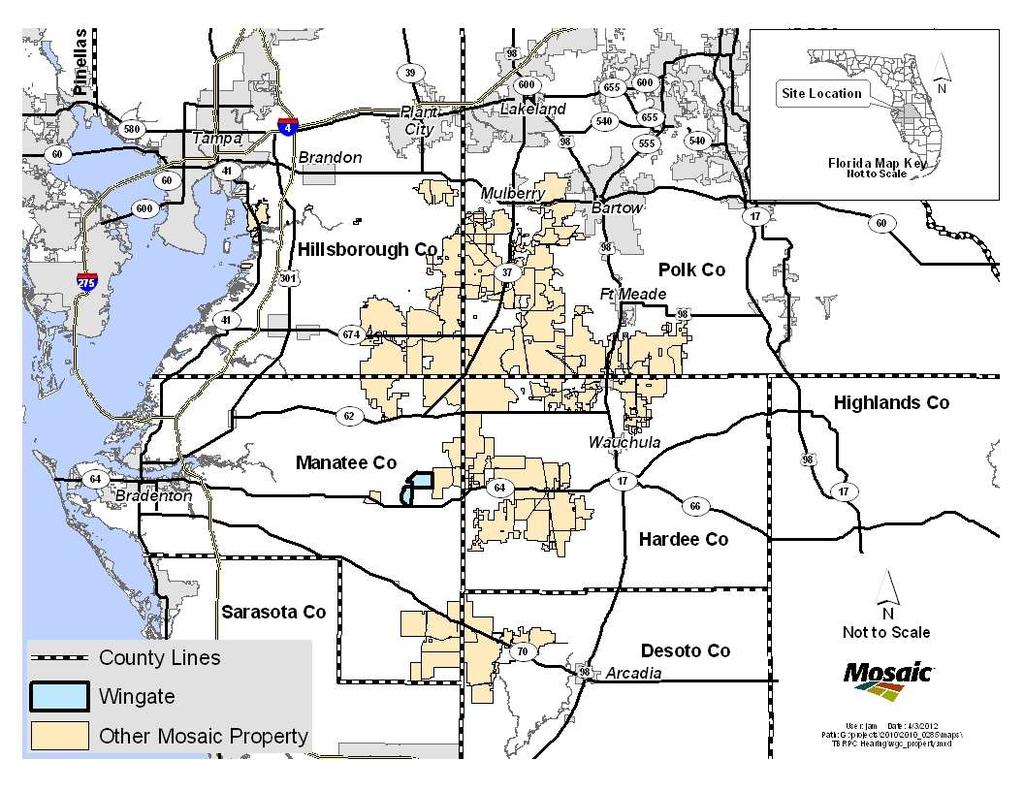
2 Business & Mission Mosaic produces the majority of the phosphate used by American farmers Employs approximately 7,000 people worldwide, 3,000 in Florida Mission To help the world grow the food it needs.


3 Mosaic: Key Role of Phosphate Phosphorus is essential to sustain all plant and animal life Required for Crop Production No Synthetic Substitute
4 U.S. Phosphate Deposits Idaho Utah North Carolina Hamilton County, Florida Central Florida
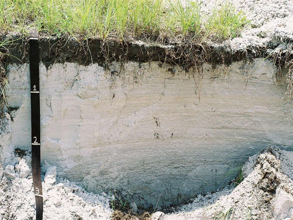
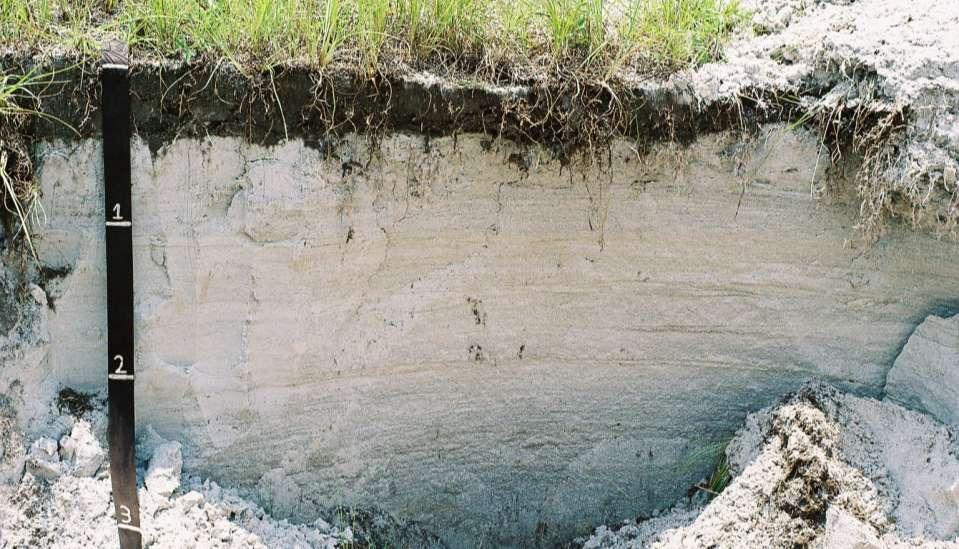
5 Geology Ground surface Overburden (sand and clay) avg 15 to 40 feet thick Matrix (ore) avg 10 to 40 feet thick Limey Bed Clay
6 Mosaic Regulatory Permits U.S. Environmental Protection Agency U.S. Fish and Wildlife Service Florida Department of Environmental Protection Florida Department of Community Affairs Florida Division of Historical Resources Southwest Florida Water Management District County Approval Hillsborough Manatee Hardee Polk DeSoto U.S Army Corps of Engineers Florida Fish and Wildlife Conservation Commission Regional Planning Council Central Florida Tampa Bay
7
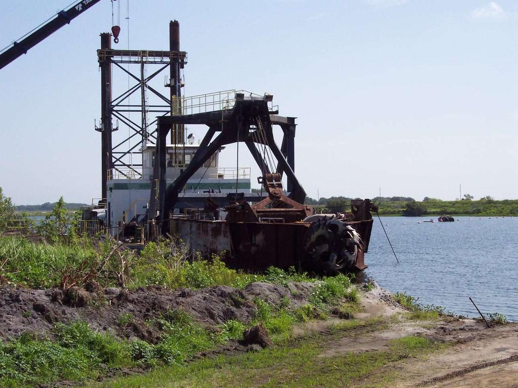
8 Spuds hold the barge in place
9 Phosphate Mining and Processing Mine Matrix Washer Dredge #2 Dredge #1 Dredge Pond Overburden Clay Slurry Phosphate Rock Stockpile Clay Settling Area
10 Phosphate Mining and Processing Oversize Mine Matrix Feed Sizing and Conditioning Washer Dredge #2 Dredge #1 Dredge Pond Overburden Clay Slurry Concentrate Phosphate Rock Stockpile Flotation Tailings sand Clay Settling Area Clay Slurry Reclamation
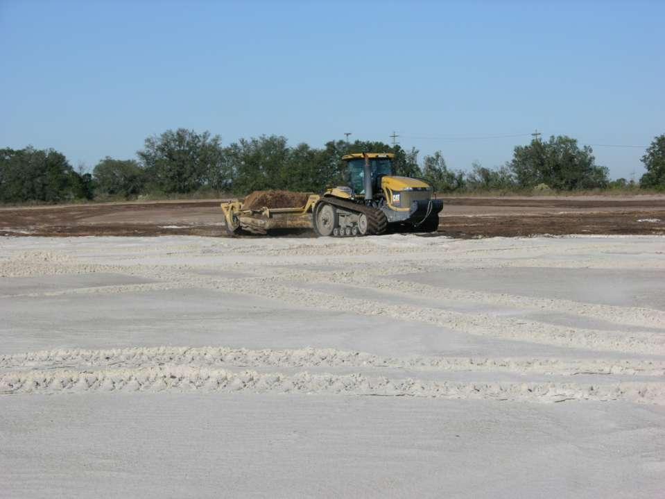
11 Mine Water Recirculation System Phosphate Mining and Processing Mine Water Recirculation System Oversize Mine Matrix Feed Sizing and Conditioning Washer Dredge Pond Overburden Clay Slurry Concentrate Phosphate Rock Stockpile Flotation Deep Well make up water Tailings sand Clay Settling Area Clay Slurry Rainfall NPDES Discharge Tailings Water and Stormwater Return To River or Stream Reclamation

")
12 NPDES Discharge Structure (Upstream Side) NPDES Discharge Structure (Downstream Side)
13 Mandatory Reclamation Under Florida Law, Mandatory Reclamation Requirements Imposed on all Lands Mined after 1975
14 Reclamation Methods Sand Backfill Shaped Fill (Land and Lakes) Crustal Development (Clay Settling Area)
15 Reclamation Methods Sand Backfill Shaped Fill (Land and Lakes) Crustal Development (Clay Settling Area)
16 Reclamation by Sand Backfill Sand Backfill Water
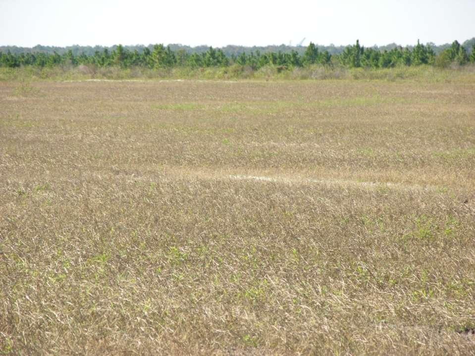
17 Reclamation by Sand Backfill Revegetation

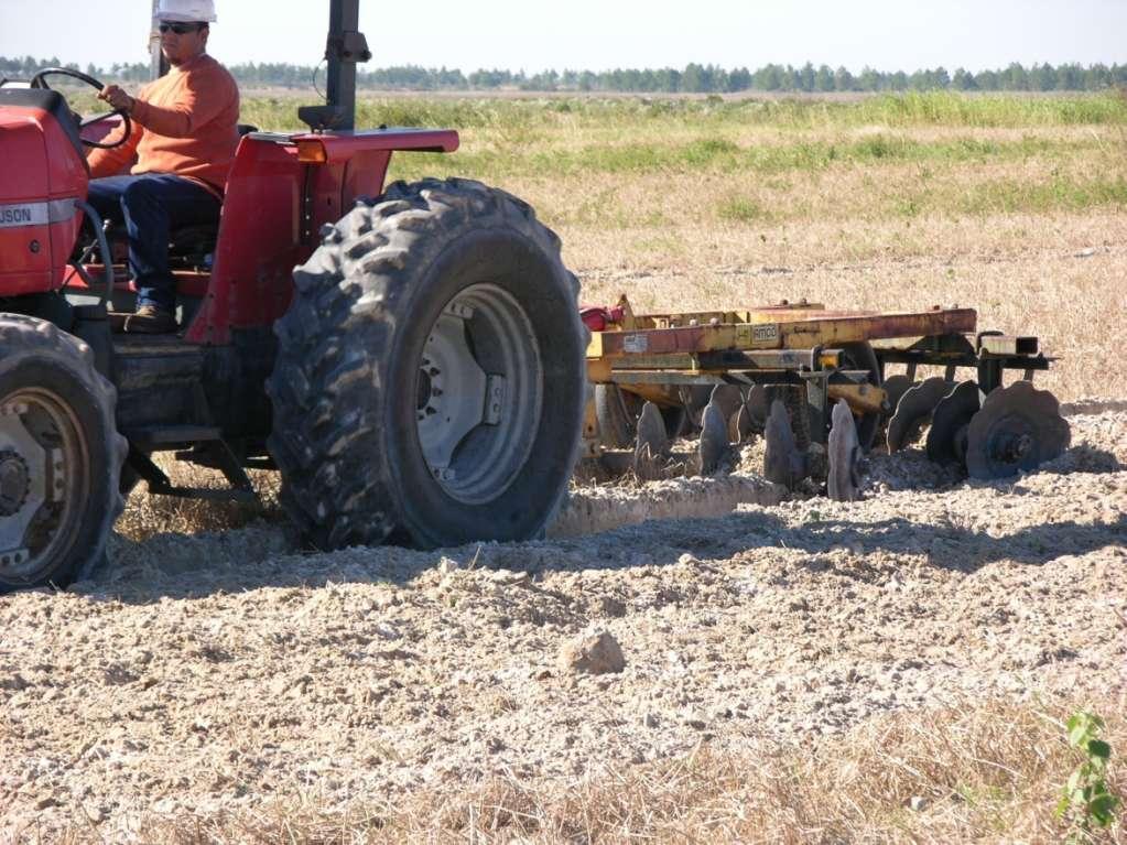
18 Surface Elevation Control GPS Antenna Blade Elevation Sensor Tractor Equipped with GPS-based Precision Grade Control

19 Surface Elevation Control Tractor Cab Display for GPS-based Precision Grade Control
20
21
22

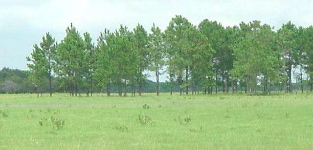
23 Reclaimed Land Unmined Land Unmined Land Reclaimed Land
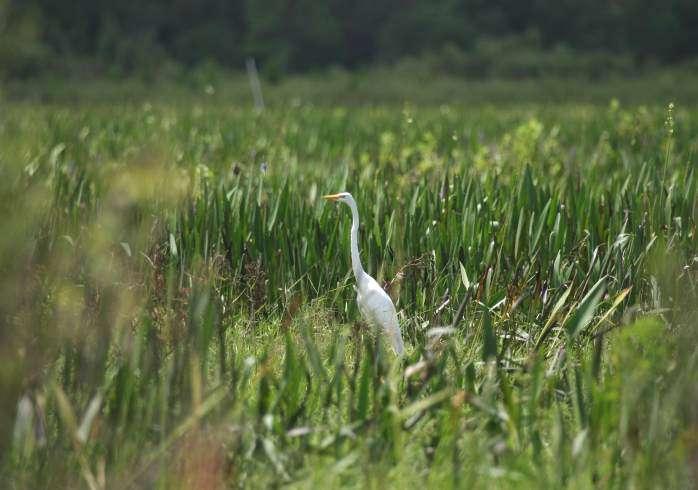
24 Freshwater Marsh:


25 Pre-Mining vs. Post Reclamation Herbaceous Wetlands Reclamation Pre-Mining
26 20
27
28 Reclamation Methods Sand Backfill Shaped Fill (Land and Lakes) Crustal Development (Clay Settling Area)
29 Reclamation by Shaped Fill (Land and Lakes) Surface Contouring
30 Reclamation by Shaped Fill (Land and Lakes)
31 Reclaimed Lake
32
33 Reclamation Methods Sand Backfill Shaped Fill (Land and Lakes) Crustal Development (Clay Settling Area)
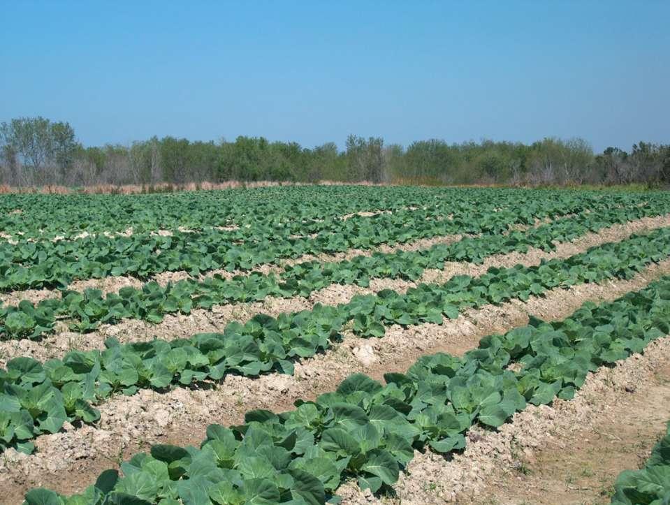
34 Reclamation by Crustal Development Dam
35 Reclamation by Crustal Development Dam Filling Complete Dam
36 Reclamation by Crustal Development Rim Ditch Constructed, Surface Dewatered, Crust Developed Dam
37
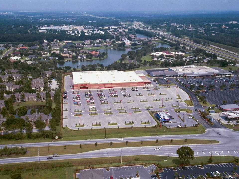
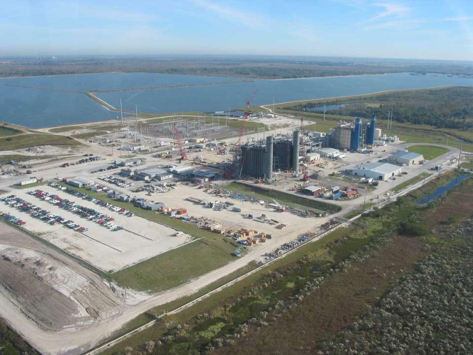
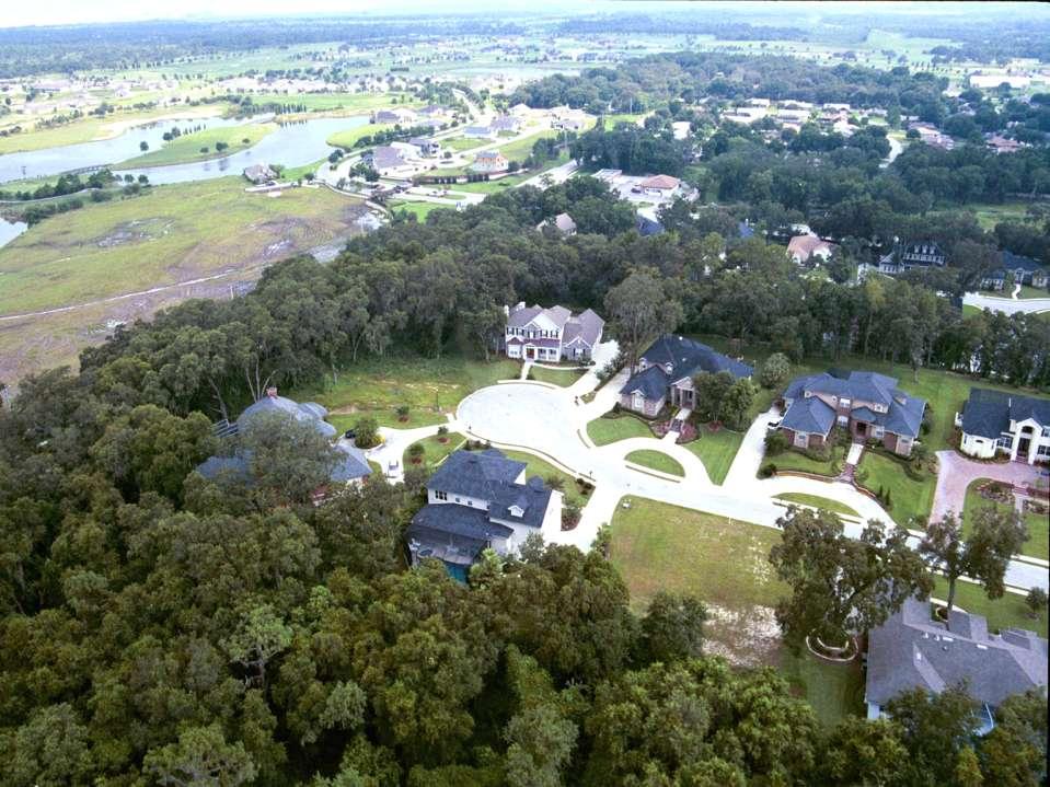
38 Reclamation by Crustal Development Dam Reshaped
39 Reclamation by Crustal Development Revegetation Complete

40 Reclamation of Clay Settling Areas Pasture on Reclaimed Clay Settling Area Fort Green Mine, FG-SP(8)
41

42 Collard Greens
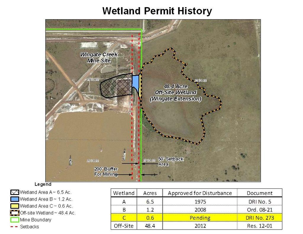
43 Cabbage

44 Broccoli Grown on Reclaimed Clay Soil

45 Cucumber Watermelon Sorghum Rice Soybeans
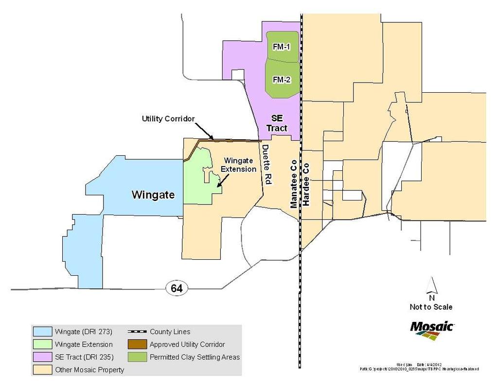
46 Post Reclamation Land Use
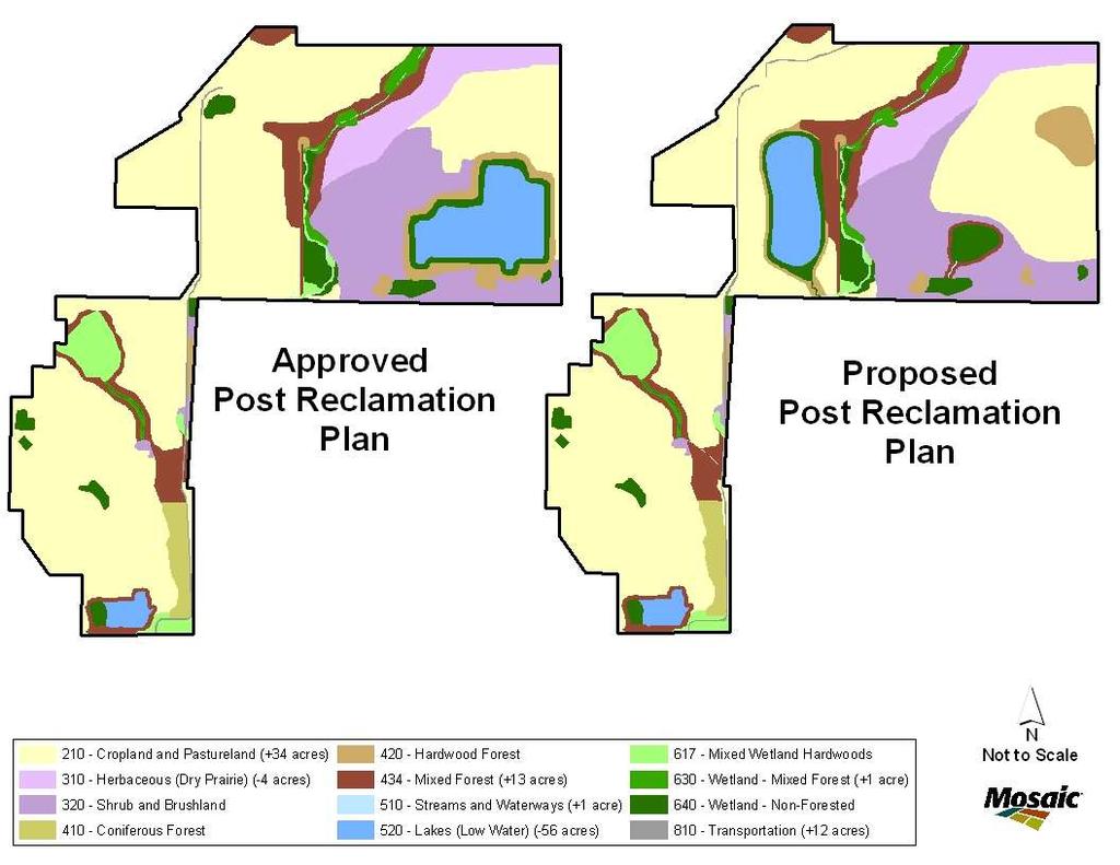
47
48
49


50 Alafia River State Park
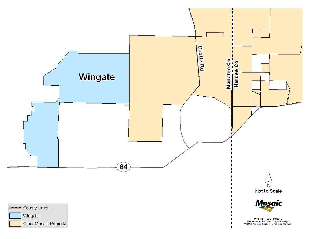
51 Wingate Creek Mine Substantial Deviation (DRI 273) Tampa Bay Regional Planning Council April 9, 2012
52
53
54 Proposed DRI-273: Wingate Substantial Deviation Process phosphate ore from Wingate Mine and Wingate Extension (adjacent Mine) to the existing Wingate Plant; Allow exchange of materials (sand, overburden, clay) between Wingate, Wingate Extension and SE Tract Modify the waste disposal plan to allow mining of Wingate Creek Mine s clay settling area Extend the mine life of Wingate Creek Mine for mining and trucking until July 2023 with reclamation continuing until December 2027 (+/-9 years) Approve the mining of 652 acres of land previously approved for disturbance within the Wingate Mine Approve the mining of 15 acres of land previously designated as undisturbed Revise mining and reclamation plans to allow the proposed activities

55 Approved Plan

56 Proposed Plan
57

58 Proposed PRLU Plan
59

60 Reclaimed Lake
61
62 No Change No Change to Water Use No Change to NPDES Outfalls No Change to Plant Capacity or Processes No Change to Shipping Methods No Change to Air Emissions No Change to Mining Methods No Change to Preservation Areas No Change to the level of employment, but existing jobs will be extended for +/- 9 years
63 Tampa Bay Regional Planning Council April 9, 2012
EAGLES NEST AND PIASA ISLANDS
 EAGLES NEST AND PIASA ISLANDS HABITAT REHABILITATION AND ENHANCEMENT PROJECT MADISON AND JERSEY COUNTIES, ILLINOIS ENVIRONMENTAL MANAGEMENT PROGRAM ST. LOUIS DISTRICT FACT SHEET I. LOCATION The proposed
Template for Sediment and Erosion Control Plan General Instructions. Section Instructions
 Template for Sediment and Erosion Control Plan General Instructions Introduction: Soil erosion and sediment deposition from farmlands can contribute to degraded surface water quality. Sediment delivery
Electronic Submission Format Guide Anthracite Preparation Plant Permit Application
 Electronic Submission Format Guide Anthracite Preparation Plant Permit Application Module 1: Application Section A through Section J, the Application Checklist, and all narrative responses Act 67 / 68
PolyMet Mining, Inc. NorthMet Project
 PolyMet Mining, Inc. NorthMet Project Addendum 01 Supplemental Information to the Wetland Delineation Report EIS Report/Study RS-14 Submitted in Support of the PolyMet Mining Inc s NorthMet Mine and Ore
Template for Sediment and Erosion Control Plan General Instructions
 Template for Sediment and Erosion Control Plan General Instructions Introduction: Soil erosion and sediment deposition from farmlands can contribute to degraded surface water quality. Sediment delivery
WELCOME Lake Wabukayne OPEN HOUSE
 WELCOME Lake Wabukayne Sediment Removal Project OPEN HOUSE We are here to: Update you, the community, on recent developments and activities at Lake Wabukayne Present the preferred alternative and receive
Analysis of Environmental Impacts from the Port of Miami Expansion. Julienne Beblo
 Analysis of Environmental Impacts from the Port of Miami Expansion Julienne Beblo 6.28.16 The Port of Miami One of the most prominent ports for global tourism and commerce Contributes $28 billion/yr to
Electronic Submission Format Guide Bituminous Coal Surface Mine Permit Application (5600-PM-BMP0311)
") Electronic Submission Format Guide Bituminous Coal Surface Mine Permit Application (5600-PM-BMP0311) Module 1: Application Section A through Section J, the Application Checklist, and all narrative responses.
Electronic Submission Format Guide Bituminous Coal Surface Mine Permit Application (5600-PM-BMP0311) Module 1: Application Section A through Section J, the Application Checklist, and all narrative responses.
Materials. Use materials meeting the following.
 208.01 Section 208. SOIL EROSION AND SEDIMENTATION CONTROL 208.01 Description. Install and maintain erosion and sedimentation controls to minimize soil erosion and to control sedimentation from affecting
Highland Lake Bathymetric Survey
 Highland Lake Bathymetric Survey Final Report, Prepared For: The Town of Highland Lake 612 Lakeshore Drive Oneonta, AL 35121 Prepared By: Tetra Tech 2110 Powers Ferry Road SE Suite 202 Atlanta, GA 30339
TAMPA BAY TRIBUTARIES BASIN. Hydrogeological Setting
 TAMPA BAY TRIBUTARIES BASIN Hydrogeological Setting Aquifers within the Tampa Bay Tributaries Basins ground water flow system include the Floridan aquifer system, the intermediate aquifer system, and the
Electronic Submission Format Guide Large Noncoal (Industrial Minerals) Mine Permit Application (5600-PM-BMP0315)
 Mine Permit Application (5600-PM-BMP0315)") Electronic Submission Format Guide Large Noncoal (Industrial Minerals) Mine Permit Application (5600-PM-BMP0315) Module 1: Application Section A through Section I, the Application Checklist, and all narrative
Electronic Submission Format Guide Large Noncoal (Industrial Minerals) Mine Permit Application (5600-PM-BMP0315) Module 1: Application Section A through Section I, the Application Checklist, and all narrative
Grand Canyon Sediment Augmentation Study. Tim Randle, P.E. Manager, Sedimentation and River Hydraulics Group, Denver, Colorado
 Grand Canyon Sediment Augmentation Study Tim Randle, P.E. Manager, Sedimentation and River Hydraulics Group, Denver, Colorado Sediment Augmentation Objectives Seasonally increase turbidity to provide cover
Continuing Education Associated with Maintaining CPESC and CESSWI Certification
 Continuing Education Associated with Maintaining CPESC and CESSWI Certification Module 2: Stormwater Management Principles for Earth Disturbing Activities Sponsors: ODOTs Local Technical Assistance Program
Oyster Reef for Shoreline Stabilization and Restoration. Jason Kirkpatrick Conservation Program Manager MacDill AFB Tampa, Florida
 Oyster Reef for Shoreline Stabilization and Restoration Jason Kirkpatrick Conservation Program Manager MacDill AFB Tampa, Florida Interbay Penninsula Port of Tampa X The few remaining mangroves are being
CR AAO Bridge. Dead River Flood & Natural Channel Design. Mitch Koetje Water Resources Division UP District
 CR AAO Bridge Dead River Flood & Natural Channel Design Mitch Koetje Water Resources Division UP District Old County Road AAO Bridge Map courtesy of Marquette County Silver Lake Basin McClure Basin
December 16, Mr. Lee Hughes Southwest Florida Water Management District Tampa Service Office 7601 Highway 301 North Tampa, FL 33637
 December 16, 2015 Mr. Lee Hughes Southwest Florida Water Management District Tampa Service Office 7601 Highway 301 North Tampa, FL 33637 RE: Response to SWFWMD Supplemental Information Request Dear Mr.
Section B - Chapter 13 Neuse River Subbasin Bay River and Pamlico Sound
 Section B - Chapter 13 Neuse River Subbasin 3-4-13 Bay River and Pamlico Sound 13.1 Subbasin Overview Subbasin 3-4-13 at a Glance Land and Water Area Total area: 277 mi 2 Land area: 145 mi 2 Water area:
1.0 PURPOSE AND FORMAT OF THE FINAL EIR
 1.0 PURPOSE AND FORMAT OF THE FINAL EIR 1.1 PROJECT OVERVIEW CEMEX (RMC Pacific Materials, dba CEMEX) operates the Bonny Doon Shale and Limestone Quarries in Santa Cruz County for the production of Portland
LOCATED IN INDIAN RIVER COUNTY PREPARED FOR S.J.R.W.M.D. AND F.W.C.D. DECEMBER, 2003 Updated 2007 Updated May 2014 PREPARED BY
 FELLSMERE WATER CONTROL DISTRICT EAST MASTER DRAINAGE PLAN AND STORMWATER HYDROLOGIC ANALYSIS OF THE GRAVITY DRAINAGE SYSTEM LOCATED BETWEEN THE EAST BOUNDARY, LATERAL U, THE MAIN CANAL, AND DITCH 24 LOCATED
The following maps must be provided as a part of the ADA. The appropriate scale for each map should be determined at the pre application conference.
 Main Street @ Coconut Creek DRI QUESTION 9 MAPS The following maps must be provided as a part of the ADA. The appropriate scale for each map should be determined at the pre application conference. Map
Subcommittee on Sedimentation Draft Sediment Analysis Guidelines for Dam Removal
 Subcommittee on Sedimentation Draft Sediment Analysis Guidelines for Dam Removal August 4, 2011 Jennifer Bountry, M.S., P.E. Tim Randle, M.S., P.E., D.WRE. Blair Greimann, Ph.D., P.E. Sedimentation and
4th Grade U.S. Regional Geography
 4th Grade U.S. Regional Geography Multiple Choice Identify the choice that best completes the statement or answers the question. What does the term mainland mean in the sentence above? A the continent
In-channel coarse sediment trap Best Management Practice
 In-channel coarse sediment trap Best Management Practice By Henry R. Hudson July 2002 Environmental Management Associates Ltd., Christchurch Complexity Environmental Value Cost Low Moderate High Low Moderate
INFLOW DESIGN FLOOD CONTROL SYSTEM PLAN 40 C.F.R. PART PLANT YATES ASH POND 2 (AP-2) GEORGIA POWER COMPANY
 GEORGIA POWER COMPANY") INFLOW DESIGN FLOOD CONTROL SYSTEM PLAN 40 C.F.R. PART 257.82 PLANT YATES ASH POND 2 (AP-2) GEORGIA POWER COMPANY EPA s Disposal of Coal Combustion Residuals from Electric Utilities Final Rule (40 C.F.R.
INFLOW DESIGN FLOOD CONTROL SYSTEM PLAN 40 C.F.R. PART 257.82 PLANT YATES ASH POND 2 (AP-2) GEORGIA POWER COMPANY EPA s Disposal of Coal Combustion Residuals from Electric Utilities Final Rule (40 C.F.R.
SAN FRANCISCO DISTRICT INFORMATION REQUESTED FOR VERIFICATION OF CORPS JURISDICTION
 DEPARTMENT OF THE ARMY SAN FRANCISCO DISTRICT, U.S. ARMY CORPS OF ENGINEERS 1455 MARKET STREET SAN FRANCISCO, CALIFORNIA 94103-1398 SAN FRANCISCO DISTRICT INFORMATION REQUESTED FOR VERIFICATION OF CORPS
TPDES: Soil, Erosion and Sedimentation Methods
 SAWS TPDES: Soil, Erosion and Sedimentation Methods Philip Handley Supervisor-Resource Protection & Compliance August 25, 2014 TPDES: Soil, Erosion and Sedimentation Methods Soil Common term: Dirt Common
TREASURE EXCAVATION MANAGEMENT PLAN. PREPARED FOR: MPE INC. PO BOX 2429 PARK CITY, UTAH
 TREASURE EXCAVATION MANAGEMENT PLAN PREPARED FOR: MPE INC. PO BOX 2429 PARK CITY, UTAH 84060 psbro23@mac.com December 15, 2008 December 15, 2008 Park City Municipal Corporation Planning Commission P.O.
Provincial Standards for Early Exploration
 Introduction Provincial Standards for Early Exploration Effective April 10, 2018 These Provincial Standards have been developed as part of the implementation of the graduated regulatory regime for early
THE MINISTRY OF ENERGY AND ENERGY INDUSTRIES MINERALS DIVISION MINE DESIGN TEMPLATE OPERATOR NAME: OPERATOR ADDRESS: PHONE NUMBER: FACSIMILE:
 THE MINISTRY OF ENERGY AND ENERGY INDUSTRIES MINERALS DIVISION MINE DESIGN TEMPLATE 1.0 GENERAL INFORMATION OPERATOR NAME: OPERATOR ADDRESS: PHONE NUMBER: FACSIMILE: NAME OF CONTACT: CELLULAR PHONE: EMAIL
Bank Erosion and Morphology of the Kaskaskia River
 Bank Erosion and Morphology of the Kaskaskia River US Army Corps Of Engineers St. Louis District Fayette County Soil and Water Conservation District Team Partners : Carlyle Lake Ecosystem Partnership Vicinity
HISTORY OF CONSTRUCTION FOR EXISTING CCR SURFACE IMPOUNDMENT PLANT GASTON ASH POND 40 CFR (c)(1)(i) (xii)
(1)(i) (xii)") HISTORY OF CONSTRUCTION FOR EXISTING CCR SURFACE IMPOUNDMENT PLANT GASTON ASH POND 40 CFR 257.73(c)(1)(i) (xii) (i) Site Name and Ownership Information: Site Name: E.C. Gaston Steam Plant Site Location:
HISTORY OF CONSTRUCTION FOR EXISTING CCR SURFACE IMPOUNDMENT PLANT GASTON ASH POND 40 CFR 257.73(c)(1)(i) (xii) (i) Site Name and Ownership Information: Site Name: E.C. Gaston Steam Plant Site Location:
Illinois River Sediment Quality and Beneficial Use Options
 Illinois River Sediment Quality and Beneficial Use Options John C. Marlin Illinois Sustainable Technology Center Robert G. Darmody Dept. of Natural Resources and Environmental Science University of Illinois
Chapter 3 Erosion in the Las Vegas Wash
 Chapter 3 Erosion in the Las Vegas Wash Introduction As described in Chapter 1, the Las Vegas Wash (Wash) has experienced considerable change as a result of development of the Las Vegas Valley (Valley).
APPENDIX B HYDROLOGY
 APPENDIX B HYDROLOGY TABLE OF CONTENTS 1.0 INTRODUCTION... 1 2.0 PROBABLE MAXIMUM PRECIPITATION (PMP)... 1 3.0 DESIGN FLOW CALCULATION... 1 4.0 DIVERSION CHANNEL SIZING... 2 5.0 REFERENCES... 4 LIST OF
Stormwater Guidelines and Case Studies. CAHILL ASSOCIATES Environmental Consultants West Chester, PA (610)
") Stormwater Guidelines and Case Studies CAHILL ASSOCIATES Environmental Consultants West Chester, PA (610) 696-4150 www.thcahill.com Goals and Challenges for Manual State Stormwater Policy More Widespread
Stormwater Guidelines and Case Studies CAHILL ASSOCIATES Environmental Consultants West Chester, PA (610) 696-4150 www.thcahill.com Goals and Challenges for Manual State Stormwater Policy More Widespread
Geomorphic Assessment of the Middle and Lower Swan Lake Watershed, Calhoun Division of Two Rivers National Wildlife Refuge.
 Geomorphic Assessment of the Middle and Lower Swan Lake Watershed, Calhoun Division of Two Rivers National Wildlife Refuge Report Figures 33 34 Figure 1. Location of Middle and Lower Swan Lake watersheds
low turbidity high turbidity
 What is Turbidity? Turbidity refers to how clear the water is. The greater the amount of total suspended solids (TSS) in the water, the murkier it appears and the higher the measured turbidity. Excessive
REGULATION OF PLACER (GOLD) MINING
 MINING") REGULATION OF PLACER (GOLD) MINING Paper presented by Brendan Gordon Placer Inspector Ministry of Energy, Mines and Petroleum Resources REGULATION OF PLACER (GOLD) MINING GENERAL GEOLOGY OF BRITISH COLUMBIA
REGULATION OF PLACER (GOLD) MINING Paper presented by Brendan Gordon Placer Inspector Ministry of Energy, Mines and Petroleum Resources REGULATION OF PLACER (GOLD) MINING GENERAL GEOLOGY OF BRITISH COLUMBIA
Regulations concerning protection of Bjørnøya Nature Reserve in Svalbard
 Regulations concerning protection of Bjørnøya Nature Reserve in Svalbard Laid down by the Royal Decree of 16 August 2002 pursuant to sections 12 and 17 of the Act of 15 June 2001 No. 79 relating to the
Alamito Creek Preserve Ranches for Sale Marfa, Presidio County, Texas
 Alamito Creek Preserve Ranches for Sale Marfa, Presidio County, Texas James King, Agent Office 432 426.2024 Cell 432 386.2821 James@KingLandWater.com Alamito Creek Preserve Various size Ranch Properties,
Implementing a Project with 319 Funds: The Spring Brook Meander Project. Leslie A. Berns
 Implementing a Project with 319 Funds: The Spring Brook Meander Project Leslie A. Berns "...to acquire... and hold lands... for the purpose of protecting and preserving the flora, fauna and scenic beauties...
MIDDLESEX COUNTY Department of Planning and Community Development P.O. Box 427, Saluda, VA Phone: Fax:
 MIDDLESEX COUNTY Department of Planning and Community Development P.O. Box 427, Saluda, VA 23149 Phone: 804-758-3382 Fax: 804-758-0061 LAND DISTURBANCE PERMIT SUBMISSION REQUIREMENTS In order to expedite
East Branch Grand Calumet River Great Lakes Legacy Act Sediment Remediation and Restoration Project
 East Branch Grand Calumet River Great Lakes Legacy Act Sediment Remediation and Restoration Project Jointly funded by the U.S. EPA Great Lakes Legacy Act, Indiana Department of Environmental Management
How & Where does infiltration work? Summary of Geologic History Constraints/benefits for different geologic units
 June 26, 2007: Low Impact Development 1 Associated Earth Sciences, Inc. Associated Earth Sciences, Inc. Presented by: Matthew A. Miller, PE April 24, 2012 How & Where does infiltration work? Summary of
REDWOOD VALLEY SUBAREA
 Independent Science Review Panel Conceptual Model of Watershed Hydrology, Surface Water and Groundwater Interactions and Stream Ecology for the Russian River Watershed Appendices A-1 APPENDIX A A-2 REDWOOD
Surface Water Short Study Guide
 Name: Class: Date: Surface Water Short Study Guide Multiple Choice Identify the letter of the choice that best completes the statement or answers the question. 1. The three ways in which a stream carries
Application #: TEXT
 TOWN OF FORT MYERS BEACH 2008 PROPOSED COMPREHENSIVE PLAN AMENDMENTS Application #: 2008-13-TEXT Description: Modify the Coastal Management and Future Land Use Elements to reflect the state s new definition
Stream Geomorphology. Leslie A. Morrissey UVM July 25, 2012
 Stream Geomorphology Leslie A. Morrissey UVM July 25, 2012 What Functions do Healthy Streams Provide? Flood mitigation Water supply Water quality Sediment storage and transport Habitat Recreation Transportation
HISTORY OF CONSTRUCTION FOR EXISTING CCR SURFACE IMPOUNDMENT PLANT GADSDEN ASH POND 40 CFR (c)(1)(i)-(xii)
(1)(i)-(xii)") HISTORY OF CONSTRUCTION FOR EXISTING CCR SURFACE IMPOUNDMENT PLANT GADSDEN ASH POND 40 CFR 257.73(c)(1)(i)-(xii) (i) Site Name and Ownership Information: Site Name: Site Location: Site Address: Gadsden
HISTORY OF CONSTRUCTION FOR EXISTING CCR SURFACE IMPOUNDMENT PLANT GADSDEN ASH POND 40 CFR 257.73(c)(1)(i)-(xii) (i) Site Name and Ownership Information: Site Name: Site Location: Site Address: Gadsden
DEPARTMENT OF GEOLOGY AND MINERAL INDUSTRIES WAYS & MEANS SUBCOMMITTEE ON NATURAL RESOURCES MARCH 2, 2017
 DEPARTMENT OF GEOLOGY AND MINERAL INDUSTRIES WAYS & MEANS SUBCOMMITTEE ON NATURAL RESOURCES MARCH 2, 2017 1 ABOUT DOGAMI AGENCY MISSION, VISION & GOALS 2 Lidar image of a stream network along the Umpqua
Sediment Traps. CAG Meeting May 21, 2012
 Sediment Traps CAG Meeting May 21, 2012 Agenda Background Fundamentals of Sediment Transport Sediment Trap Existing Information Next Steps 2 The Site Saginaw River 22 mile river beginning at confluence
White River Update. Jeanne Stypula, Supervising Engineer. Advisory Committee Meeting April 26, 2016
 White River Update Jeanne Stypula, Supervising Engineer Advisory Committee Meeting April 26, 2016 Department of Natural Resources and Parks Water and Land Resources Division River and Floodplain Management
City of Six Project. Gold Mining Property in Downieville, CA. 60 Acres of Claims. Estimated Resource of over 8,800 ounces of Gold
 City of Six Project Gold Mining Property in Downieville, CA 60 Acres of Claims Estimated Resource of over 8,800 ounces of Gold Adjoining the famous Ruby Mine Property Located on a Rich Tertiary Channel
 Red River Flooding June 2015 Caddo and Bossier Parishes Presented by: Flood Technical Committee Where the Rain Falls Matters I-30 versus I-20 I-20 Backwater and Tributary Floods (Localized) 2016 Flood
U.S. ARMY CORPS OF ENGINEERS
 CORPS FACTS Regulating Mississippi River Navigation Pools U.S. ARMY CORPS OF ENGINEERS BUILDING STRONG Historical Background Federal improvements in the interest of navigation on the Mississippi River
Hydraulic Impacts of Limestone Quarries and Gravel Pits. Jeff Green Minnesota DNR-Division of Ecological & Water Resources
 Hydraulic Impacts of Limestone Quarries and Gravel Pits Jeff Green Minnesota DNR-Division of Ecological & Water Resources The Hydraulic Impacts of Limestone Quarries and Gravel Pits Study was funded by
FOR PROJECTS INITIATED AFTER NOVEMBER 1, 2008 ITEM 716 EMBANKMENT EARTH OUTLET SEDIMENT TRAP
 AFTER NOVEMBER 1, 2008 ITEM 716 EMBANKMENT EARTH OUTLET SEDIMENT TRAP 716.1 Description. This work shall consist of furnishing, installing, maintaining, and removing temporary erosion protection and sediment
Griswold Creek August 22, 2013
 Creek August 22, 2013 1 Lake Erie Protection Fund Creek Study ver Evaluate the overall condition of Creek Determine stable channel dimensions & appropriate restoration techniques Starting Stat gpoint for
Ms. A. Mormando's Class *
 8 th Grade Science Essential Standard: 8.E.1.1 Explain the structure of the hydrosphere including: Water distribution on Earth; Local river basin and water availability Stream - A stream is a body of water
1.1 What is Site Fingerprinting?
 Site Fingerprinting Utilizing GIS/GPS Technology 1.1 What is Site Fingerprinting? Site fingerprinting is a planning tool used to design communities where protection of natural resources is the primary
NRCS - THUNDER ROAD #3, TRIBUTARY TO QUILEUTE RIVER CULVERT REMOVAL AND REPLACEMENT PLAN CLALLAM COUNTY, WA., WRIA: 20, SITE:
 WDFW CONTROL POINT #1 Re-Bar, Elevation Northing 10004.441 Easting 8002.5905 WDFW CONTROL POINT #2 Re-Bar, Elevation 101.36 Northing 10031.6683 Easting 846.0623 Spike in Tree Elevation = 102.95 Elevation
APPROVED JURISDICTIONAL DETERMINATION FORM U.S. Army Corps of Engineers
 APPROVED JURISDICTIONAL DETERMINATION FORM U.S. Army Corps of Engineers This form should be completed by following the instructions provided in Section IV of the JD Form Instructional Guidebook. SECTION
Learning Objectives: I can identify and interpret river flows and directions.
 Learning Objectives: I can identify and interpret river flows and directions. Bellringer Review: Check for Understanding Questions: 1 2 What Are The Key Parts Of A River s Anatomy? In your data notebooks
NRCS - THUNDER ROAD #2, TRIBUTARY TO QUILEUTE RIVER CULVERT REMOVAL AND REPLACEMENT PLAN CLALLAM COUNTY, WA., WRIA: 20, SITE:
 WDFW CONTROL POINT #1 Re-Bar, Elevation 100.00 Northing 10004.441 Easting 8002.5905 WDFW CONTROL POINT #2 Re-Bar, Elevation 101.36 Northing 10031.6683 Easting 846.0623 WDFW TBM #1 Spike in Tree Elevation
Changes in Texas Ecoregions Copy the questions and answers
 Changes in Texas Ecoregions Copy the questions and answers 1. What are some kinds of damage that hurricanes cause? Roads and bridges might be washed away. Trees and power lines can be knocked down. Area
4.9 GEOLOGY AND SOILS
 4.9 GEOLOGY AND SOILS 4.9.1 EXISTING CONDITIONS TOPOGRAPHY AND RELIEF Zone 40 is located in the central portion of Sacramento County. The topography of the county is represented by three physiographic
GEOLOGY AND SOILS. This chapter summarizes geologic and geotechnical aspects of the site as they relate to the Project.
 9 GEOLOGY AND SOILS INTRODUCTION This chapter summarizes geologic and geotechnical aspects of the site as they relate to the Project. This chapter utilizes information from the following reports prepared
Lake Sedimentation Survey of Siloam Springs State Park Lake, Adams County, Illinois
 Contract Report 567 Lake Sedimentation Survey of Siloam Springs State Park Lake, Adams County, Illinois by Richard L. Allgire Office of Sediment & Wetland Studies Prepared for the Illinois Department of
Earth Wind & Fire. Game Changing Restoration Options in the Texas Chenier Plain
 Earth Wind & Fire Game Changing Restoration Options in the Texas Chenier Plain EARTH: The Chenier Plain is a 5 million acre coastal region in Southwest Louisiana and Southeast Texas providing landscape
Reconnaissance of Coal-Slurry Deposits in Indiana. IGS Web Report
 Reconnaissance of Coal-Slurry Deposits in Indiana Denver Harper Chris Dintaman Maria Mastalerz Sally Letsinger August 1, 2006 - April 30, 2007 Indiana Geological Survey Bloomington, Indiana 1 IGS Web Report
Considerations for Mechanical Dredging, Hydraulic Dredging and Mechanical Dewatering of Sediments
 Considerations for Mechanical Dredging, Hydraulic Dredging and Mechanical Dewatering of Sediments Authors: Jerry Vetter & Eric Zeigler Contractor s Perspective Previous Dredging and Dewatering Projects
3.11 Floodplains Existing Conditions
 Other stormwater control practices may be needed to mitigate water quality impacts. In addition to detention facilities, other practices such as vegetated basins/buffers, infiltration basins, and bioswales
IMPORTANCE OF GEOLOGIC CHARACTERIZATION FOR LEVEE FOUNDATION AND BORROW MATERIALS AS STUDIED AT THE INDIAN GRAVES LEVEE DISTRICT, ADAMS COUNTY, IL
 IMPORTANCE OF GEOLOGIC CHARACTERIZATION FOR LEVEE FOUNDATION AND BORROW MATERIALS AS STUDIED AT THE INDIAN GRAVES LEVEE DISTRICT, ADAMS COUNTY, IL Conor Watkins Missouri University of Science and Technology
Mineral Resources
 Sacramento Local Agency Formation Commission Mineral Resources 3.11 - Mineral Resources 3.11.1 - Introduction This section describes and evaluates potential environmental impacts to mineral resources resulting
Project (Project No. US-CA-62-2) Maintenance Inspection and Reports (Subtask 14.1) Inspection Report No.2
 Maintenance Inspection and Reports (Subtask 14.1) Inspection Report No.2") MEMORANDUM TO: FROM: Jim Well, Ducks Unlimited Mike Harvey, PhD, PG SUBJECT: M&T/ Llano Seco Fish Screen Project (Project No. US-CA-62-2) Maintenance Inspection and Reports (Subtask 14.1) Inspection Report
MEMORANDUM TO: FROM: Jim Well, Ducks Unlimited Mike Harvey, PhD, PG SUBJECT: M&T/ Llano Seco Fish Screen Project (Project No. US-CA-62-2) Maintenance Inspection and Reports (Subtask 14.1) Inspection Report
Island Design. UMRS EMP Regional Workshop. Presentation for the
 Island Design Presentation for the UMRS EMP Regional Workshop by Jon Hendrickson Hydraulic Engineer Regional Technical Specialist, Water Quality and Habitat Restoration August 17 19, 2005 Project Delivery
4.12 Mineral Resources
 4.12.1 Setting Section 2.2, Project Location, provides general information about the Project s regional and local setting. This Section 4.12.1 provides setting information specific to mineral resources.
Kootenai River Habitat Restoration Program Update
 Kootenai River Habitat Restoration Program Update Kootenai Tribe of Idaho Kootenai Valley Resource Initiative November 19, 2012 Bonners Ferry, Idaho Changes to Kootenai Basin Beaver trapping Floodplain
Delaware Bay Dikes Repair and Prevention Project Preliminary Design for New Castle Dikes
 City of New Castle Presentation Delaware Bay Dikes Repair and Prevention Project Preliminary Design for New Castle Dikes New Castle Conservation District DNREC August 22, 2012 Agenda Project Background
Why Geomorphology for Fish Passage
 Channel Morphology - Stream Crossing Interactions An Overview Michael Love Michael Love & Associates mlove@h2odesigns.com (707) 476-8938 Why Geomorphology for Fish Passage 1. Understand the Scale of the
STUDY GUIDE FOR CONTENT MASTERY. Surface Water Movement
 Surface Water SECTION 9.1 Surface Water Movement In your textbook, read about surface water and the way in which it moves sediment. Complete each statement. 1. An excessive amount of water flowing downslope
GROUNDWATER MONITORING DATA 2016 SAMPLING EVENT HARSHAW CHEMICAL COMPANY FUSRAP SITE
 GROUNDWATER MONITORING DATA 2016 SAMPLING EVENT HARSHAW CHEMICAL COMPANY FUSRAP SITE U.S. Army Corps of Engineers Buffalo District Building Strong April 2017 ly Utilized Sites Remedial Action Program The
Planning for the Future of Humboldt Bay: Sea Level Rise, Sediment Management, Sand Spits and Salt Marshes. Joel Gerwein
 Planning for the Future of Humboldt Bay: Sea Level Rise, Sediment Management, Sand Spits and Salt Marshes Joel Gerwein Introduction to Humboldt Bay Setting Economy, community, and environment Sediment
Roger Andy Gaines, Research Civil Engineer, PhD, P.E.
 Roger Andy Gaines, Research Civil Engineer, PhD, P.E. Research Civil Engineer/Regional Technical Specialist Memphis District August 24, 2010 Objectives Where we have been (recap of situation and what s
3.3 CLIMATE, GEOLOGY, TOPOGRAPHY, AND SOILS CLIMATE GEOLOGY TOPOGRAPHY
 3.3 CLIMATE, GEOLOGY, TOPOGRAPHY, AND SOILS This section describes the climate, geology, topography, and soil resource characteristics of the Yolo Bypass Wildlife Area (Wildlife Area). Agricultural soil
Controlling Processes That Change Land
 1 Name Date Controlling Processes That Change Land People try to control some of the processes that change land. To do this, people apply technology- the use of science to solve problems in everyday life.
Fate of historic metal releases from the Coeur d Alene mining district Northern Idaho
 Fate of historic metal releases from the Coeur d Alene mining district Northern Idaho Stephen E. Box US Geological Survey U.S. Metal Production Coeur d'alene, ID Butte, MT Tintic-East Tintic, UT Ag (10
Natural Shoreline Landscapes on Michigan Inland Lakes
 Natural Shoreline Landscapes on Michigan Inland Lakes Excerpts from Chapters 2 and 3 Photo Photo by Jane by Jane Herbert Herbert Did you know? Twenty-four species of amphibians, 25 species of reptiles,
ATTACHMENT D SNOW REMOVAL AND DE-ICING PROCEDURES
 Interstate Reliability Project 345-kV Transmission Lines Development & Management Plan Volume 2 ATTACHMENT D SNOW REMOVAL AND DE-ICING PROCEDURES INTERSTATE RELIABILITY PROJECT The Interstate Reliability
Chapter 2 Roanoke River Subbasin Including: Dan and Mayo Rivers, Pawpaw and Jacobs Creek
 Chapter 2 Roanoke River Subbasin 03-02-02 Including: Dan and Mayo Rivers, Pawpaw and Jacobs Creek 2.1 Subbasin Overview Subbasin 03-02-02 at a Glance Land and Water Area Total area: 231 mi 2 Land area:
CWC Water Plan
 CWC Water Plan ----------------------------------------------------------------------------------------------------------------------------- IMPLEMENTATION: MISSISSIPPI RIVER The begins as a trickle flowing
Doug Belden, Tax Collector. Detailed Distribution Data Report
 Doug Belden, Tax Collector Hillsborough County Tax Collector P.O. Box 30012 Tampa, Florida 33630-3012 http://www.hillstax.org Detailed Distribution Data Report Run: 09/30/2014 Report Description DISTRIBUTION
LESSONS LEARNED FROM MINING-INFLUENCED WATERS STUDIES AT THE NEW MEXICO BUREAU OF GEOLOGY AND MINERAL RESOURCES
 LESSONS LEARNED FROM MINING-INFLUENCED WATERS STUDIES AT THE NEW MEXICO BUREAU OF GEOLOGY AND MINERAL RESOURCES Virginia T. McLemore New Mexico Bureau of Geology and Mineral Resources New Mexico Institute
TRI-STATE WATERS COMMISSON An Inventory of Its Red River of the North Drainage Basin Maps and Graphs
 MINNESOTA HISTORICAL SOCIETY Minnesota State Archives TRI-STATE WATERS COMMISSON An Inventory of Its Red River of the North Drainage Basin Maps and Graphs OVERVIEW OF THE RECORDS Agency: Tri-State Waters
NORTHUMBERLAND COUNTY, PA
 QUAKER RUN Stream and Wetland Restoration As-Built Completion Report and First Year Monitoring Data Coal Township NORTHUMBERLAND COUNTY, PA Upstream Before Upstream After Prepared for: COAL TOWNSHIP 805
6 MACRAES MINING PROJECT MINERAL ZONE
 6 MACRAES MINING PROJECT MINERAL ZONE 6.1 ZONE STATEMENT The Macraes Mining Zone applies to the area of land controlled by Macraes Mining Limited and included in Mining Permit 41-064 at the date of public
Stormwater Outlet Sediment Traps
 Stormwater Outlet Traps SEDIMENT CONTROL TECHNIQUES Photo 1 Excavated sediment trap just prior to scheduled clean-out (note energy dissipater at end of pipe) Photo 2 A supplementary straw bale barrier
MAPS AND THEIR CLASSIFICATION
 MAPPING MAPS AND THEIR CLASSIFICATION WHAT IS A MAP? A map is representation of the Earth's surface, showing how things are related to each other by distance, direction, and size. Maps are a way of showing
A Geomorphologist's Perspective on "Natural Stream" Applications in Mine Reclamation
 A Geomorphologist's Perspective on "Natural Stream" Applications in Mine Reclamation Dr. Steve Kite, West Virginia University Department of Geology & Geography National Interactive Forum on Geomorphic