Stormwater Guidelines and Case Studies. CAHILL ASSOCIATES Environmental Consultants West Chester, PA (610)
|
|
|
- Ferdinand O’Connor’
- 5 years ago
- Views:
Transcription
1 Stormwater Guidelines and Case Studies CAHILL ASSOCIATES Environmental Consultants West Chester, PA (610)
2 Goals and Challenges for Manual State Stormwater Policy More Widespread Use of BMPs Address All Elements of Stormwater: Volume Peak Rate (Municipal Ordinance) Channel Protection Quality Recharge
3 Stormwater Forum May 28th 2004 Guideline 1 1. Hold the runoff volume constant for up to the 2 year storm. 2. Peak Rates held to predevelopment levels for the year storm. 3. Quality - Reduction of 85% of particulate associated pollutants (as represented by TSS) and 50% of solutes (as represented by NO3-N)
4 Stormwater Forum May 28th 2004 Guideline 2 Special Areas 1. Baseflow! Infiltrate Runoff from the first 1 of Rainfall 2. Quality! Reduction of 85% of particulate associated pollutants (as represented by TSS) and 50% of solutes (as represented by NO3-N) 3. Channel Protection! Release the post construction 1 year (24 hr) storm over at least 24 hours. 4. Flood Protection! Peak Rates held to predevelopment levels for the year storm
5 Challenges More Widespread Use of BMPS, but How to Calculate? How to Show Compliance? Municipal Review and Approval Peak Rate Attenuation There is no benefit to the developer if the Design Engineer cannot get credit for BMPs.
6
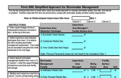
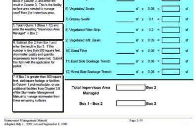
7 What Have Other States/Cities Done? Portland, OR Simplified Method Worksheets Specific Details for BMPs Alternative Methods Allowed
8

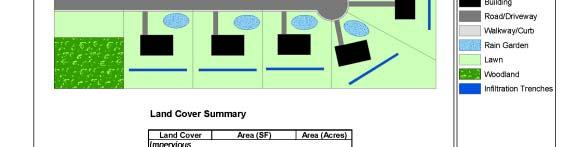
9 BMPs that receive direct credit Deciduous Trees = 100 SF 6 Trees = 600 SF Impervious Area that is managed
10 Planter Box 1000 SF Impervious x 0.06 = 60 SF


11 Vegetated Filter Strip 2,600 SF Impervious x 0.2 = 520 SF
12 Portland, OR Simplified Method Add up Areas Managed by Different BMPs Tells User How Much of a BMP is needed If Less Than 500 Square Feet Unmanaged, You re Done! Alternative Methods Allowed
13 What Have Other States/Cities Done? Georgia Manual Water Quality Worksheets Credit for Structural Non-structural Submitted for Regulatory Review
14 Drainage Area 01 Land Use Distribution (acres) Enter Total Area : Enter Impervious Area (IA) : Enter Disturbed Pervious Area (DP) : Enter Natural Conservation Area (NC) : NC 20% IA 40% Total Area for check : Percent Imperviousness (%) : 40% DP 40% Non-Structural Controls (Site Design Credits) Water Quality Volume (WQ V ) Natural Conservation Area (acres): 2.00 WQ V (ac-ft) w/o Credits = Enter Area (acres) Treated by (if applicable): Undisturbed Stream Buffers : 2.00 Vegetated Channels : 2.00 Overland Flow Filtration / Recharge : Total Area receiving Credits (acres): 6.00 WQv (acre-feet) WQ V w/ Non-Struc. Credits = w/o Credits w/ Credits
15 Structural Controls Select Structural Control(s) Control 1 Bioretention Area BRA-01-1 Control 2 NONE NONE Control 3 NONE NONE Control 4 NONE NONE Control 5 NONE NONE TSS Reduction Chart TSS Reduction from Control ID 80% Structural Controls: Additional Downstream Treatment If the runoff leaving this drainage area is treated by one or more additional structural controls downstream, please specify the appropriate drainage area(s) below: Total TSS Reduction Using Non-Structural Controls (Site Design Credits), Structural Controls, and Additional Downstream Treatment (if applicable): 84% Local Government Specific Information (fill in only if required by Development Review Department) TSS Reduction 100% 75% 50% 25% 0% 1 Cumulative Reduction Efficiency Adjusted BMP Efficiency Reduction Target Control Number DA 2 DA 3 DA 4 DA 5 DA 6 DA 7 DA 8 DA 9 DA 10 Watershed Basin: District/LL/Parcel: Comm. District:
16 Name of Developer: Development Name: Site Location / Address: Development Type: Area of Development (acres): Georgia Stormwater Management Manual Stormwater Quality Site Development Review Tool John Q. Developer Happy Acres Office/Professional General Information Date Submitted: Permit Number: Developer Contact: Phone Number: Name of Engineer(s): Maintenance Responsibility: Number of Drainage Areas: Total # of Structural Controls Used: 1 General Application Structural Stormwater Limited Application Structural Stormwater Controls Controls Stormwater Pond 0 Filter Strip 0 Sum of Drainage Areas (ac) : Stormwater Wetland 0 Grass Channel 0 Bioretention Area 1 Organic Filter 0 Total (IA) Impervious Area (ac) : 4.00 Sand Filter 0 Underground Sand Filter 0 Total (DP) Disturbed Pervious Area (ac) : 4.00 Infiltration Trench 0 Submerged Gravel Wetland 0 Total (NC) Natural Conservation Area (ac) : 2.00 Enhanced Swales 0 Gravity (Oil-Grit) Separator 0 TSS Reduction Detention Structural Stormwater Controls Porous Concrete** 0 Percent Imperviousness (%) : 40% Dry Detention / Dry ED Basin 0 Modular Porous Paver System** 0 TSS Reduction Total TSS Reduction (%) : 84% 100% 75% 50% 25% 84% Summary of Site and Structural Control Information Land Use Distribution Pie NC 20% DP 40% IA 40% Multi-Purpose Detention Area 0 Alum Treatment System 0 Underground Detention 0 Proprietary Structural Control*** 0 Tracking #: Reviewed By: Date Approved: Conditions of Approval: Official Use Only 0% 0% 0% 0% 0% 0% 0% 0% DA1 0% DA2 DA3 DA4 DA5 0% DA6 DA7 DA8 DA9 DA10
17 Other States New Jersey Worksheet to Calculate Required Recharge Pervious and Impervious Calculated Separately Delaware DURMM Quality and Infiltration One BMP
18 Proposal for Pennsylvania: A Simplified Method Worksheet for Designers Demonstrate Compliance for: Volume Rate Water Quality Stream Protection Municipal Approval and NPDES Permit Alternative Methodologies Accepted
19 Critical Challenges: Linking Volume, Rate, and Quality Decentralized Linking Many BMPs Providing a Tool for LID Design Calculations Providing a Tool to Calculate Volume How Does the Designer Provide Stormwater Calculations?
20
21
22 Residential Two Case Studies Ten Lots Conveyance to Detention Basin 20% Impervious Commercial Big Box 52,000 Square Feet Building, 248 Parking Spaces Detention Basin 60% Impervious Compare Conventional and BMP Design


23 Site Assumptions Ten Acres Undeveloped 70% Meadow, 30% Woods C Soils 8% Slope
24 Methodology USDA NRCS Cover Complex Mitigate Peak Rates 2-Year to 100-Year Events 1-Year 2.4 in 2-Year 2.8 in 10-Year 4.3 in 100-Year 5.8 (Blair County) Impervious and Pervious Areas Considered Separately Curve Number Time of Concentration Tc Infiltration: National Engineering Handbook Chapter 12 Site Average affected by Head Provide Calculations for Municipal Approval


25 Detention Basin Storage: 40,000 cubic-feet 20% Impervious

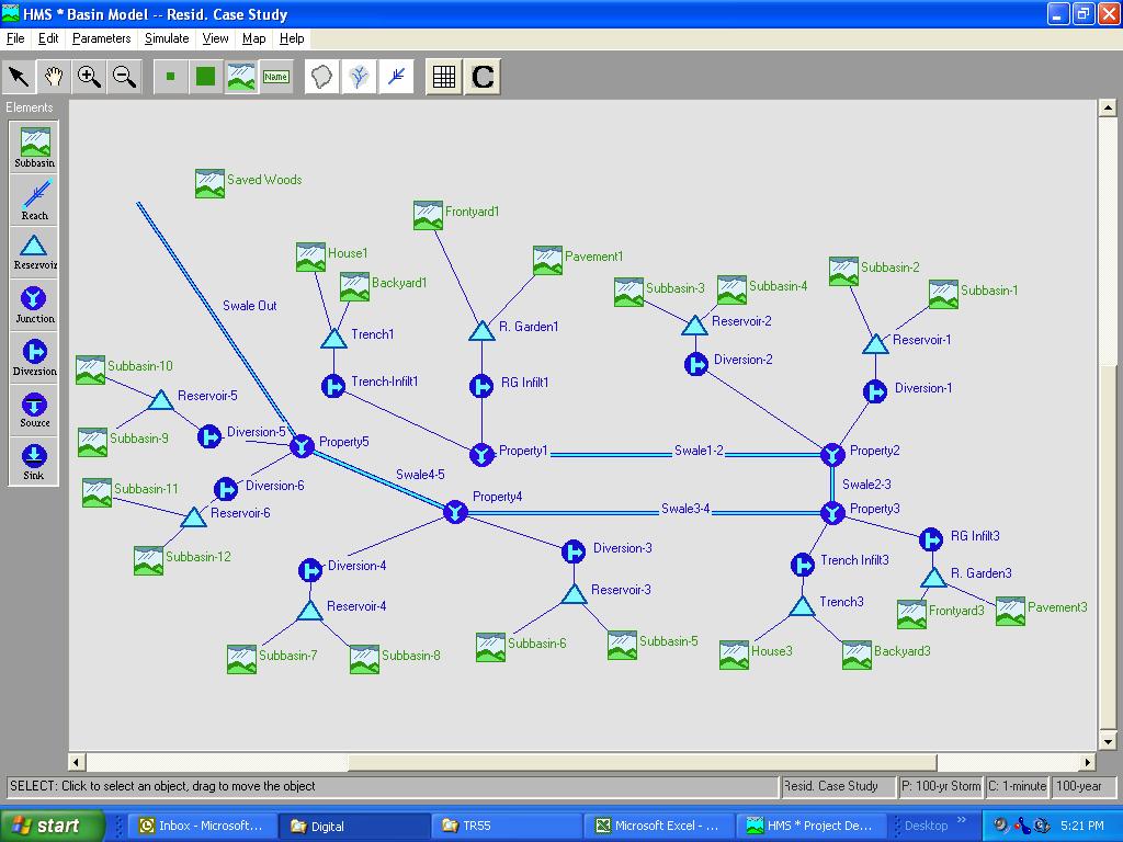
26 Residential Routing Through Detention Basin
27 Residential Detention Basin BB Elevation Elev. (ft) Area (ft 2 ) Volume in Pipes (ft 3 ) Volume a (ft 3 ) Total Storage Volume (ft 3 ) Total Storage Volume (ac-ft) For Rectangular Weir Head (ft) Discharge Coefficien t, Cd Weir Length (ft) Capacity (cfs) Low-flow Infiltration Orifice Q=A*Infiltr ation Rate b (cfs) Q=CdA(2 gh) 1/2 (cfs) Q, total c (cfs) Stage Storage Discharge Table 40,000 cubic-feet Multi-Stage Outlet Only Managed Large Storm Peak
28 yr Storm Hydrograph Comparison - Residential Case Study Detention Basin Pre-Dev. Det. Basin Post-Dev. no mitigation Flow (cfs) :00 3:00 6:00 9:00 12:00 15:00 18:00 21:00 0:00 Time

29 BMP Design


30 20% Impervious 2,000 SF Rain Garden on each Lot Infiltration Trench/Vegetated Swale for Conveyance Storage in BMPs = 2-year Volume Increase 27,600 CF
31 2-year Storm Land Cover Area (SF) Curve Initial Abstraction 2.8 inches Number (I a ), in. Inches CF Lawn 304, ,521 R. Gardens 20, ,282 Impervious 87, ,652 Meadow Woods 23, ,200 TOTAL 435, ,655 Lawn Det. Basin Impervious Meadow 304, ,469 Woods 130, ,600 TOTAL Net Difference 435, ,069 27,586 Proposed Existing 2-Year Volume Increase = 27,600 CF
32 Designer s Question: Rain Gardens sound good, but how do I calculate Peak Rate Control and gain Municipal Approval?? Residential Routing Through Detention Basin
33
34 INFILTRATION TRENCH TABLE Stage (ft) Storage Total Discharge Infilt. (cfs) (CF) (cfs) RAIN GARDEN TABLE Stage (ft) Storage Total Infilt. (cfs) (CF) Discharge (cfs) Stage-Storage- Discharge Table for Every BMP?! Route every BMP to Calculate Peak Rate from Site?! What was my budget for this job? Forget It!
35 We did the calculations Compare Runoff Volume Compare Peak Rates Can BMP Method Mitigate Peak Rate for Municipal Approval?
36 Peak Rate Mitigation Detention Storm Event Pre-Dev. Peak (cfs) Post-Dev. Peak (cfs) Post-Dev. Peak w/ Basin (cfs) Change (%) % % % % Storm Event Pre-Dev. Peak (cfs) BMP Design Post-Dev. Peak (cfs) Post-Dev. Peak w/ Volume Control (cfs) Change (%) % % % %
37 Increase in Volume Detention Storm Pre-Dev. Post-Dev. Event Runoff (in.) Runoff (in.) Change (%) % % % % BMPs Storm Pre-Dev. Post-Dev. Event Runoff (in.) Runoff (in.) Change (%) % % % %
38 Residential Development 2-Year 7 Pre-Dev. 6 Det. Basin BMP Design 5 Flow (cfs) :00 3:00 6:00 9:00 12:00 15:00 18:00 21:00 0:00 Time
39 Residential Development 100-Year 35 Pre-Dev. 30 Det. Basin BMP Design 25 Flow (cfs) :00 3:00 6:00 9:00 12:00 15:00 18:00 21:00 0:00 Time

40

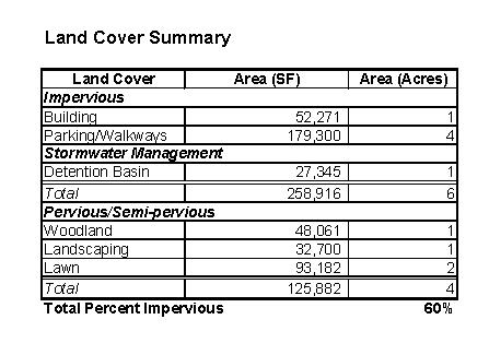
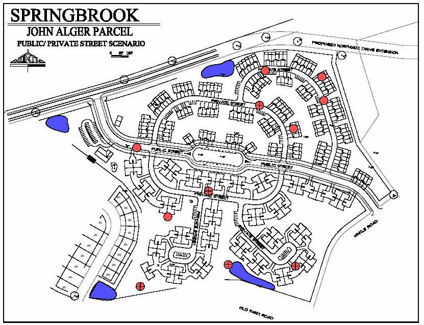
41 Second Case Study: Commercial Conventional 52,000 Square Feet Building, 248 Parking Spaces 1.46 acre-feet Detention Basin 60% Impervious
42 Commercial Conventional

43 Routing Through Detention Basin
44 Commercial Detention Basin BB Elevation Elev. (ft) Area (ft 2 ) Volume in Pipes (ft 3 ) Volume a (ft 3 ) Total Storage Volume (ft 3 ) Total Storage Volume (ac-ft) For Rectangular Weir Head (ft) Discharge Coefficien t, Cd Weir Length (ft) Capacity (cfs) Low-flow Infiltration Orifice Q=A*Infiltr ation Rate b (cfs) Q=CdA(2 gh) 1/2 (cfs) Q, total c (cfs) Tc Before = 20 Minutes Tc After = 15 Minutes Pervious Tc After = 6 Minutes Impervious
45 Alternative Design Commercial Bioretention Areas Storage/Infiltration Beneath Parking Area National Engineering Handbook, Chap 12 Conservative Estimate Swales to Lengthen Tc Storage Equal to 2-Year Increase in Volume: 1.05 acre-feet
46 Commercial BMP
47 Commercial BMP
48 Proposed Condition BMP Design 2-year Storm Land Cover Area (SF) Curve Initial Abstraction 2.8 inches Number (I a ), in. Inches CF Lawn/Landscaping 82, ,212 Building 52, ,191 Impervious 179, ,387 Bioretention ,533 Meadow Woods ,343 TOTAL 435, ,665 Existing Condition 2-year Storm Land Cover Area (SF) Curve Initial Abstraction 2.8 inches Number (I a ), in. Inches CF Lawn Impervious Meadow 304, ,469 Woods 130, ,600 TOTAL 435, ,069 Net Difference BMP Design 45,596 cf 2-Year Volume Increase = 45,596 CF = 1.05 AF

49 Commercial BMP How to Model / Calculate?

50 Routing Through BMPs
51 Routing BMP Design BB Elevation Elev. (ft) Area (ft 2 ) Volume in Pipes (ft 3 ) Surface Storage (ft 3 ) Total Storage Volume (ft 3 ) Total Storage Volume (ac-ft) Nyloplast Inlet Head (ft) Discharge Coefficient, Cd Weir Length (ft) Capacity from graph (cfs) Infiltration Q=A*Infiltration Rate b (cfs) Low-flow Orifice Q=CdA(2gh) 1/2 (cfs) Outlet Orifice Q=CdA(2gh) 1/2 (cfs) Q, total (cfs) Bioretention Storage/Infiltration Beneath Parking Vegetated Drainage Swales Undisturbed Woods instead of Basin
52 % % % % Peak Rate Mitigation Detention Storm Event Pre-Dev. Peak (cfs) Post-Dev. Peak (cfs) Post-Dev. Peak w/ Basin (cfs) Change (%) % % % % BMP Design Storm Event Pre-Dev. Peak (cfs) Post-Dev. Peak (cfs) Post-Dev. Peak w/ Basin (cfs) Change (%)
53 Increase in Volume Detention Storm Event Pre-Dev. Runoff (in.) Post-Dev. Runoff (in.) Change (%) % % % % BMPs Storm Event Pre-Dev. Runoff (in.) Post-Dev. Runoff (in.) Change (%) % % % %
54 Commercial Development 2-Year 2-yr Storm Hydrograph Comparison Flow (cfs) :00 9:00 18:00 Time (hrs) Det. Basin BMP Design Pre-Dev.
55 Commercial Development 100-Year 100-yr Storm Hydrograph Comparison Flow (cfs) :00 9:00 18:00 Time (hrs) Det. Basin BMP Design Pre-Dev.
56 Proposal for BMP Manual: Simplified Method and Worksheets Calculate Volume Increase from Land Use Change Calculate Contribution of BMPs Detailed Routing May Be Waived Design Standards Must Be Met Alternative Analysis Accepted
57 Volume Calculation WORKSHEET 1. CHANGE IN RUNOFF VOLUME FOR 2-YR STORM EVENT PROJECT: Big Box Store DA: 1 2-Year Rainfall: 2.8 Existing Conditions: Cover Type Soil Area CN S Ia Runoff Runoff Type (ac) (in) (CF) Woodland C ,058 Meadow C ,399 TOTAL: 10 22,457 Developed Conditions: Cover Type Soil Area CN S Ia Runoff Runoff Type (sf) (in) (CF) Lawn C ,110 Impervious C ,174 Landscaping C ,843 Detention Basin C ,875 Meadow C Woods C ,420 TOTAL: 10 69,423 2-Year Volume Increase (cf): 46,965 AF 1.1
58 PROJECT: Big Box SUB-BASIN: 1 Required Control Volume 46,965 cf Proposed Measures Measure Type Area Storage Volume Provided per SF* Net Storage Volume (sf) (cf/sf) (cf) Structural Storage/Infiltration Bed 22, ,700 Bioretention 19, ,865 Vegetated Swale 1, Tree Trench Green Roof Wet Pond Non-Structural Riparian Buffer Woodland Protection TOTAL STORAGE : REQ'D STORAGE (WS 1): DIFFERENCE 100
59 Proposal for BMP Manual: If 2-Year Volume Increase Can Be Managed by BMPs: Water Quality Requirement Met Channel Protection Requirement Met Peak Rate Requirement Met If not Water Quality Peak Rate (Routing) Channel Protection
60 Water Quality Calculation WORKSHEET 3. WATER QUALITY - 85% TSS CONTROL PROJECT: Big Box Store DA: 1 2-Year Rainfall: 2.8 Existing Conditions: Cover Type TSS EMC Runoff TSS Load mg/l (CF) (lbs) Woodland 40 7, Meadow 70 15, TOTAL: 22, Developed Conditions: Cover Type TSS EMC Runoff TSS Load mg/l (CF) (lbs) Lawn 100 8, Impervious , Landscaping 100 2, Detention Basin 100 5, Meadow Woods 40 2, TOTAL: 69, TSS Load Increase (lb): 70
61 Why Do We Need This? Linking Volume, Rate, and Quality Decentralized Linking Many BMPs Providing a Tool for LID Design Calculations
62
63
64
65 Stormwater Forum May 28th 2004 Guideline 1 1. Hold the runoff volume constant for up to the 2 year storm. 2. Peak Rates held to predevelopment levels for the year storm. 3. Quality - Reduction of 85% of particulate associated pollutants (as represented by TSS) and 50% of solutes (as represented by NO3-N)
66 Stormwater Forum May 28th 2004 Guideline 2 Special Areas 1. Baseflow! Infiltrate Runoff from the first 1 of Rainfall 2. Quality! Reduction of 85% of particulate associated pollutants (as represented by TSS) and 50% of solutes (as represented by NO3-N) 3. Channel Protection! Release the post construction 1 year (24 hr) storm over at least 24 hours. 4. Flood Protection! Peak Rates held to predevelopment levels for the year storm
STREUVER FIDELCO CAPPELLI, LLC YONKERS DOWNTOWN DEVELOPMENT PHASE 1. DRAFT ENVIRONMENTAL IMPACT STATEMENT For: PALISADES POINT
 STREUVER FIDELCO CAPPELLI, LLC YONKERS DOWNTOWN DEVELOPMENT PHASE 1 DRAFT ENVIRONMENTAL IMPACT STATEMENT For: PALISADES POINT Prepared by: PAULUS, SOKOLOWSKI & SARTOR STORMWATER MANAGEMENT 1. Methodology
City of Columbia BMP Manual. Detailed Unified Sizing Criteria Example Wet Pond Design
 City of Columbia BMP Manual Detailed Unified Sizing Criteria Example Wet Pond Design April 17, 2013 Wet Pond Example: Unified Sizing Criteria Methodology Base Data Location: Rome, GA Site Drainage Area
STORMWATER MANAGEMENT COMPUTATIONS. Mount Prospect
 STORMWATER MANAGEMENT COMPUTATIONS Mount Prospect MHG PROJECT No. 2011.173.11 November 6, 2014 Prepared for: Piney Meetinghouse Investments c/o Mr. Dennis Fling 14801 Clopper Road Boyds, MD 20841 (301)
WATER MANAGEMENT REPORT FOR PAGE ESTATES
 WATER MANAGEMENT REPORT FOR PAGE ESTATES SLB Consulting of SW Florida, LLC PO Box 2826 Bonita Springs, FL. 34133 Phone: 239-948-9566 sandra@slbconsult.com C.O.A. # 25395 September 1, 2014 Sandra L. Bottcher
ARTICLE 5 (PART 2) DETENTION VOLUME EXAMPLE PROBLEMS
 DETENTION VOLUME EXAMPLE PROBLEMS") ARTICLE 5 (PART 2) DETENTION VOLUME EXAMPLE PROBLEMS Example 5.7 Simple (Detention Nomograph) Example 5.8 Offsite and Unrestricted Areas (HEC-HMS) Example 5.9 Ponds in Series w/ Tailwater (HEC-HMS) Example
ARTICLE 5 (PART 2) DETENTION VOLUME EXAMPLE PROBLEMS Example 5.7 Simple (Detention Nomograph) Example 5.8 Offsite and Unrestricted Areas (HEC-HMS) Example 5.9 Ponds in Series w/ Tailwater (HEC-HMS) Example
STORMWATER REPORT FRITO LAY SUBDIVISION NO. 3
 STORMWATER REPORT FRITO LAY SUBDIVISION NO. 3 May 2018 STORMWATER REPORT I. Subdivision Data a. The parcel is adjacent to the existing Frito Lay property in Topeka; and the subject plat application encompasses
Continuing Education Course #101 Drainage Design with WinTR-55
 1 of 5 Continuing Education Course #101 Drainage Design with WinTR-55 1. WinTR-55 uses the Kinematic Wave method for calculating storm runoff rates and volumes. 2. According to the Velocity Method, the
DAVID NOEL KELLY CIVIL. David Noel Kelly :24:14-04'00'
 DAVID NOEL KELLY CIVIL David Noel Kelly 2014.07.22 10:24:14-04'00' TABLE OF CONTENTS Stormwater Management Summary Checklist for Stormwater Report Illicit Discharge Statement Runoff Summary Existing Conditions
City of Thornton Attn: Tim Semones Development Engineeering 9500 Civic Center Dr. Thornton, CO 80229
 Development Engineering Land Surveying Construction Administration District Services October 20, 2017 City of Thornton Attn: Tim Semones Development Engineeering 9500 Civic Center Dr. Thornton, CO 80229
Section 4: Model Development and Application
 Section 4: Model Development and Application The hydrologic model for the Wissahickon Act 167 study was built using GIS layers of land use, hydrologic soil groups, terrain and orthophotography. Within
LOCATED IN INDIAN RIVER COUNTY PREPARED FOR S.J.R.W.M.D. AND F.W.C.D. DECEMBER, 2003 Updated 2007 Updated May 2014 PREPARED BY
 FELLSMERE WATER CONTROL DISTRICT EAST MASTER DRAINAGE PLAN AND STORMWATER HYDROLOGIC ANALYSIS OF THE GRAVITY DRAINAGE SYSTEM LOCATED BETWEEN THE EAST BOUNDARY, LATERAL U, THE MAIN CANAL, AND DITCH 24 LOCATED
INFLOW DESIGN FLOOD CONTROL SYSTEM PLAN 40 C.F.R. PART PLANT YATES ASH POND 2 (AP-2) GEORGIA POWER COMPANY
 GEORGIA POWER COMPANY") INFLOW DESIGN FLOOD CONTROL SYSTEM PLAN 40 C.F.R. PART 257.82 PLANT YATES ASH POND 2 (AP-2) GEORGIA POWER COMPANY EPA s Disposal of Coal Combustion Residuals from Electric Utilities Final Rule (40 C.F.R.
INFLOW DESIGN FLOOD CONTROL SYSTEM PLAN 40 C.F.R. PART 257.82 PLANT YATES ASH POND 2 (AP-2) GEORGIA POWER COMPANY EPA s Disposal of Coal Combustion Residuals from Electric Utilities Final Rule (40 C.F.R.
EROSION CONTROL NARRATIVE
 EROSION CONTROL NARRATIVE Erosion and sediment control has been designed for the Willow Bend Phase I Subdivision according to UDFCD and the City of Thornton criteria, in order to minimize erosion and sediment
WQ Outlet Design Single Orifice Orifice diameter = 24. Perforated riser/orifice Plate Outlet area per perforation row = 4
 These calculations should be used when designing the outlet structures for extended wet and dry detention basins (Sections 4. 7 and 4.8). The water quality outlet size and the trash rack design will vary
This site will utilize an infiltration berm to manage the two-year/24-hour volume increase.
 Gates TETRA TECH, INC. By: RH Date: 1/30/2017 Subject: Gates Road Checked By: JB Date: 2/1/2017 PCSM Design and Evaluation PURPOSE: The purpose of these calculations is to design a Post-Construction Stormwater
STORMWATER MANAGEMENT REPORT
 STORMWATER MANAGEMENT REPORT THE FAIRWAYS AT EDGEWOOD LOTS 5 & 6, BLOCK 1201 TOWNSHIP OF RIVER VALE BERGEN COUNTY, NEW JERSEY PREPARED BY: DAPHNE A. GALVIN PROFESSIONAL ENGINEER LICENSE NO. 24GE03434900
TPDES: Soil, Erosion and Sedimentation Methods
 SAWS TPDES: Soil, Erosion and Sedimentation Methods Philip Handley Supervisor-Resource Protection & Compliance August 25, 2014 TPDES: Soil, Erosion and Sedimentation Methods Soil Common term: Dirt Common
Sacramento Area Hydrology Model (SAHM) Guidance Document. Clear Creek Solutions, Inc.
 Guidance Document. Clear Creek Solutions, Inc.") Sacramento Area Hydrology Model (SAHM) Guidance Document Clear Creek Solutions, Inc. www.clearcreeksolutions.com ii To download the Sacramento Area Hydrology Model and the electronic version of this document,
Sacramento Area Hydrology Model (SAHM) Guidance Document Clear Creek Solutions, Inc. www.clearcreeksolutions.com ii To download the Sacramento Area Hydrology Model and the electronic version of this document,
Project Description. Project Options. End Analysis On... Apr 26, :00:00. Rainfall Details
 Project Description File Name... 323 - Att Pond 3 East PIPES ONLY.SPF Project Options Flow Units... Elevation Type... Hydrology Method... EPA SWMM Infiltration Method... Link Routing Method... Enable Overflow
This site will utilize an infiltration berm to manage the two-year/24-hour volume increase.
 Gates TETRA TECH, INC. By: RH Date: 11/11/2016 Subject: Gates Road Checked By: JB Date: 11/13/2016 PCSM Design and Evaluation PURPOSE: The purpose of these calculations is to design a Post-Construction
This site will utilize an infiltration berm to manage the two-year/24-hour volume increase.
 High Street TETRA TECH, INC. By: RH Date: 1/30/2017 Subject: High Street Checked By: JB Date: 2/1/2017 PCSM Design and Evaluation PURPOSE: The purpose of these calculations is to design a Post-Construction
HYDROLOGY REPORT Tentative Tract No. 5978
 ATTACHMENT 5 October 2016 HYDROLOGY REPORT Tentative Tract No. 5978 City of Simi Valley County of Ventura Prepared For: Landsea Holdings Corporation 7525 Irvine Center Drive Suite 200 Irvine, CA 92618
Monitoring Considerations and Costs
 Monitoring Considerations and Costs Stormwater BMP Selection, Design, and Monitoring Florida Stormwater Association September 9, 2016 Harvey H. Harper, Ph.D., P.E. Environmental Research & Design, Inc.
Continuing Education Associated with Maintaining CPESC and CESSWI Certification
 Continuing Education Associated with Maintaining CPESC and CESSWI Certification Module 2: Stormwater Management Principles for Earth Disturbing Activities Sponsors: ODOTs Local Technical Assistance Program
D.M. Wills Associates Limited PARTNERS IN ENGINEERING. Stormwater Management Report. City of Peterborough
 Stormwater Management Report City of Peterborough P-20-12 Parkway Corridor Class Environmental Assessment Jackson Park Parkhill Road West to Chemong Road D.M. Wills Project No. 12-5061 D.M. Wills Associates
Sediment Control Practices. John Mathews Ohio Dept. of Natural Resources, Division of Soil and Water Resources
 Sediment Control Practices John Mathews Ohio Dept. of Natural Resources, Division of Soil and Water Resources Practices Treat the Largest Soil Particles Sand Sand Silt Clay Treated Untreated Settleable
The Effect of Stormwater Controls on Sediment Transport in Urban Streams
 Hydrology Days 2004 The Effect of Stormwater Controls on Sediment Transport in Urban Streams Christine A. Rohrer, P.E. 1 Master s Candidate, Department of Civil Engineering, Colorado State University,
Sediment Capture in Pervious Concrete Pavement tsystems: Effects on Hydrological Performance and Suspended Solids
 Concrete Sustainability Conference April 14 th 2010, Tempe, AZ Sediment Capture in Pervious Concrete Pavement tsystems: Effects on Hydrological l Performance and Suspended Solids Discharge Luis A. Mata,
The effectiveness of the Natural Resource Conservation Service (NRCS) and Huff rainfall distribution methods for use in detention basin design
 and Huff rainfall distribution methods for use in detention basin design") Scholars' Mine Masters Theses Student Theses and Dissertations Spring 2010 The effectiveness of the Natural Resource Conservation Service (NRCS) and Huff rainfall distribution methods for use in detention
Scholars' Mine Masters Theses Student Theses and Dissertations Spring 2010 The effectiveness of the Natural Resource Conservation Service (NRCS) and Huff rainfall distribution methods for use in detention
DRAINAGE REPORT FOR THORNTON SELF STORAGE THORNTON, COLORADO
 DRAINAGE REPORT FOR THORNTON SELF STORAGE THORNTON, COLORADO Prepared by: Bowman Consulting 603 Park Point Dr. Suite 100 Golden, CO 80401 (303)-801-2900 June 29, 2015 Revised August 14, 2015 CERTIFICATE
Chapter 10 - Sacramento Method Examples
 Chapter 10 Sacramento Method Examples Introduction Overview This chapter presents two example problems to demonstrate the use of the Sacramento method. These example problems use the SACPRE and HEC-1 computer
Table of Contents Project Description... 1 Summary of Existing Conditions... 1 Summary of Proposed Conditions... 1 Stormwater Compliance... 2 Collecti
 Table of Contents Project Description... 1 Summary of Existing Conditions... 1 Summary of Proposed Conditions... 1 Stormwater Compliance... 2 Collection... 2 Treatment... 3 Storage... 3 Disposal... 4 Soils...
INTRODUCTION TO HYDROLOGIC MODELING USING HEC-HMS
 INTRODUCTION TO HYDROLOGIC MODELING USING HEC-HMS By Thomas T. Burke, Jr., PhD, PE Luke J. Sherry, PE, CFM Christopher B. Burke Engineering, Ltd. October 8, 2014 1 SEMINAR OUTLINE Overview of hydrologic
September 6, City of Thornton 9500 Civic Center Drive Thornton, CO (303) RE: Maverik Thornton, CO - Drainage Report
 RE: Maverik Thornton, CO - Drainage Report") September 6, 2016 City of Thornton 9500 Civic Center Drive Thornton, CO 80229 (303) 538-7295 RE: Maverik Thornton, CO - Drainage Report As per your request, we are submitting to you the drainage report
September 6, 2016 City of Thornton 9500 Civic Center Drive Thornton, CO 80229 (303) 538-7295 RE: Maverik Thornton, CO - Drainage Report As per your request, we are submitting to you the drainage report
Drainage Analysis. Appendix F
 Drainage Analysis Appendix F Golden View Drive Elizabeth Street LMORE CREEK Ricky Road Rabbit Creek Road LITTLE RABBIT CREEK East 156th Avenue MOA Project #10-026 Golden View Drive Intersection
Urban Hydrology for Small Watersheds
 United States Department of Agriculture Natural Resources Conservation Service Conservation Engineering Division Urban Hydrology for Small Watersheds TR-55 Technical Release 55 June 1986 To show bookmarks
Section 3.0 Existing Systems Hydrology and Hydraulics
 Section 3.0 Existing Systems Hydrology and Hydraulics This chapter summarizes the results and methodology of MACTEC s evaluation of the existing drainage systems and lakes for the City of Maitland, Florida.
Standards for Soil Erosion and Sediment Control in New Jersey May 2012
 STANDARD FOR SEDIMENT BASIN Definition A barrier, dam, excavated pit, or dugout constructed across a waterway or at other suitable locations to intercept and retain sediment. Basins created by construction
Hydrology and Hydraulics Design Report. Background Summary
 To: National Park Services Montezuma Castle National Monument Richard Goepfrich, Facility Manager From: Multicultural Technical Engineers Date: Tuesday - February 13, 2018 Subject: 30% Hydrology and Hydraulics
Advanced /Surface Hydrology Dr. Jagadish Torlapati Fall 2017 MODULE 2 - ROUTING METHODS
 Routing MODULE - ROUTING METHODS Routing is the process of find the distribution of flow rate and depth in space and time along a river or storm sewer. Routing is also called Flow routing or flood routing.
PONDNET.WK1 - Flow and Phosphorus Routing in Pond Networks
 PONDNET.WK1 - Flow and Phosphorus Routing in Pond Networks Version 2.1 - March 1989 William W. Walker, Jr. Ph.D., Environmental Engineer 1127 Lowell Road, Concord, Massachusetts 01742 508-369-8061 PONDNET.WK1
SWAMP GIS: A spatial decision support system for predicting and treating stormwater runoff. Michael G. Wing 1 * and Derek Godwin
 Journal of Spatial Hydrology Vol. 11, No. 2 Fall 2011 SWAMP GIS: A spatial decision support system for predicting and treating stormwater runoff Michael G. Wing 1 * and Derek Godwin Abstract SWAMP GIS
FHWA - HIGHWAY HYDROLOGY
 The unit peak discharge is computed with Equation 5.6 by interpolating c 0, c, and c Table 5.5 using a type II distribution. The peak discharge is also calculated as follows. from Variable SI Unit U Unit.5444
Coal Combustion Residuals Unit Inflow Design Flood Control System Plan
 Coal Combustion Residuals Unit Inflow Design Flood Control System Plan Virginia Electric and Power Company Chesterfield Power Station Upper (East) Pond Chesterfield County, Virginia GAI Project Number:
PARADIGM ODP FORT COLLINS, CO 80525
 DRAINAGE REPORT PARADIGM ODP FORT COLLINS, CO 80525 Prepared For: Paradigm Properties, LLC 2186 Knoll Drive Ventura, CA 93003 Prepared By Coffey Engineering & Surveying 4045 St. Cloud Drive, Suite 180
Implementing a Thermal Urban Runoff Model (TURM)
") 20 Implementing a Thermal Urban Runoff Model (TURM) K.E. Arrington, J.M. Norman, A. Roa-Espinosa and S.J. Ventura An Erosion Control and Stormwater Management Ordinance was recently adopted in Dane County,
20 Implementing a Thermal Urban Runoff Model (TURM) K.E. Arrington, J.M. Norman, A. Roa-Espinosa and S.J. Ventura An Erosion Control and Stormwater Management Ordinance was recently adopted in Dane County,
Suitable Applications Sediment traps should be considered for use:
 Categories EC Erosion Control SE Sediment Control TC Tracking Control WE Wind Erosion Control Non-Stormwater NS Management Control Waste Management and WM Materials Pollution Control Legend: Primary Objective
STORMWATER DESIGN CALCULATIONS
 STORMWATER DESIGN CALCULATIONS REF : C7011-2390 AT 19a-23 MEMORIAL AVENUE BLACKWALL FOR MR KERR Contents 1.0 Detention System Requirements 1.1 Storage-Area calcs. 1.2 Data Files for Pre & Post Developed
******************* Project Description ******************* File Name... NAAF Stormwater Improvement Project 11_21_2014.SPF
 Autodesk Storm and Sanitary Analysis 2014 - Version 8.1.62 (Build 1) ----------------- *** Project Description *** File Name... NAAF Stormwater Improvement Project 11_21_2014.SPF Analysis Options Flow
BRANDON LAKES AVENUE PRE AND POST CONDITIONS DRAINAGE REPORT
 BRANDON LAKES AVENUE PRE AND POST CONDITIONS DRAINAGE REPORT Hillsborough County Public Works County Center, 22nd Floor 601 E. Kennedy Blvd. Tampa, FL 33602 BRANDON LAKES AVENUE DRAINAGE IMPROVEMENTS Capital
STORMWATER MANAGEMENT ASSESSMENT TECHNICAL MEMORANDUM DRAFT FINAL FOSTER DRIVE AREA SANITARY SERVICING AND STORMWATER MANAGEMENT CLASS EA
 The City of Committed to Total Service Excellence STORMWATER MANAGEMENT ASSESSMENT TECHNICAL MEMORANDUM DRAFT FINAL FOSTER DRIVE AREA SANITARY SERVICING AND STORMWATER MANAGEMENT CLASS EA April 2015 Revised
Stage Discharge Tabulation for Only Orifice Flow
 Stage Discharge Tabulation for Only Orifice Flow DEPTH STAGE DISCHARGE (meters) (feet) (meters) (feet) (m 3 /s) (ft 3 /s) 0 0.20 0.40 0.60 0.80 1.00 1.20 1.40 1.60 1.80 2.00 0.7 1.3 2.0 2.6 3.3 3.9 4.6
CITY OF CAPE CORAL STORMWATER MASTER PLAN PHASE II - PART 1 BASINS 4, 10, & 14 SUB-BASIN DRAINAGE IMPROVEMENTS HYDRAULIC ANALYSIS SUMMARY
 CITY OF CAPE CORAL STORMWATER MASTER PLAN PHASE II - PART 1 BASINS 4, 10, & 14 SUB-BASIN DRAINAGE IMPROVEMENTS HYDRAULIC ANALYSIS SUMMARY Cape Coral, FL Prepared for: The City of Cape Coral Public Works
MIDDLESEX COUNTY Department of Planning and Community Development P.O. Box 427, Saluda, VA Phone: Fax:
 MIDDLESEX COUNTY Department of Planning and Community Development P.O. Box 427, Saluda, VA 23149 Phone: 804-758-3382 Fax: 804-758-0061 LAND DISTURBANCE PERMIT SUBMISSION REQUIREMENTS In order to expedite
Sediment Trap. A temporary runoff containment area, which promotes sedimentation prior to discharge of the runoff through a stabilized spillway.
 Sediment Trap SC-15 Source: Caltrans Construction Site Best Management Practices Manual, 2003. Description A temporary runoff containment area, which promotes sedimentation prior to discharge of the runoff
3.11 Floodplains Existing Conditions
 Other stormwater control practices may be needed to mitigate water quality impacts. In addition to detention facilities, other practices such as vegetated basins/buffers, infiltration basins, and bioswales
Sediment Trap. At multiple locations within the project site where sediment control is needed.
 Sediment Trap SE-3 Objectives EC Erosion Control SE Sediment Control TR Tracking Control WE Wind Erosion Control Non-Stormwater NS Management Control Waste Management and WM Materials Pollution Control
APPENDIX B DESIGN CRITERIA FOR TEMPORARY WATER QUALITY BMPS USED DURING CONSTRUCTION
 APPENDIX B DESIGN CRITERIA FOR TEMPORARY WATER QUALITY BMPS USED DURING CONSTRUCTION This Appendix presents design criteria and example calculations for the following temporary water quality BMPs for use
Hydrology Study Report
 Hafeez Consulting www.hafeezconsulting.com Civil/ Structural Engineering, Design & Construction 1451 S. Hacienda St. Anaheim CA 92804 (714) 225-4565 Fax (714)917-2977 engineer@hafeezconsulting.com Hydrology
Submitted to: St. Johns River Power Park New Berlin Road Jacksonville, FL 32226
 RUN-ON/RUN-OFF CONTROL SYSTEM PLAN RUN-ON AND RUN-OFF CONTROL SYSTEM PLAN St. Johns River Power Park Byproduct Storage Area B Phase I Development Submitted to: St. Johns River Power Park 11201 New Berlin
How & Where does infiltration work? Summary of Geologic History Constraints/benefits for different geologic units
 June 26, 2007: Low Impact Development 1 Associated Earth Sciences, Inc. Associated Earth Sciences, Inc. Presented by: Matthew A. Miller, PE April 24, 2012 How & Where does infiltration work? Summary of
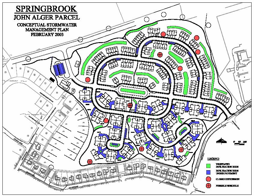
University of the Virgin Islands Conceptual Stormwater Management Plan Coral Bay Watershed Final Letter Report (May 2005)
") Final Letter Report (May 2005) Background The Coral Bay watershed, shown in Figure 1, is located in the southeastern portion of the island of St. John, U.S. Virgin Islands (USVI) and consists of approximately
Final Letter Report (May 2005) Background The Coral Bay watershed, shown in Figure 1, is located in the southeastern portion of the island of St. John, U.S. Virgin Islands (USVI) and consists of approximately
Simulating the groundwater discharge to wetlands. Mukwonago Basin Example and Potential Application in Dane County
 Simulating the groundwater discharge to wetlands Mukwonago Basin Example and Potential Application in Dane County Conceptual Model Topography is major control on flow to wetlands Land Surface Water Table
WELCOME Lake Wabukayne OPEN HOUSE
 WELCOME Lake Wabukayne Sediment Removal Project OPEN HOUSE We are here to: Update you, the community, on recent developments and activities at Lake Wabukayne Present the preferred alternative and receive
North Wales PRP for Wissahickon Creek Nutrients
 North Wales PRP for Wissahickon Creek Nutrients July 14, 2017 Revised September 7, 2017 Revised August 9, 2018 Prepared for: North Wales Borough 300 School Street North Wales, PA 19454 Corporate Headquarters
EROSION CONTROL NARRATIVE
 EROSION CONTROL NARRATIVE Erosion and sediment control has been designed for the Willow Bend Phase I Subdivision according to UDFCD and the City of Thornton criteria, in order to minimize erosion and sediment
D. B. G R A Y E N G I N E E R I N G I N C.
 STORMWATER MANAGEMENT REPORT 948 Hunt lub Road Ottawa, Ontario Report No. 12020-SWM August 27, 2012 Revised April 21, 2014 Revised December 9, 2014 Revised April 14, 2015 D. B. G R A Y E N G I N E E R
Final Drainage Report
 Final Drainage Report Expo Rail Operations and Maintenance Facility Santa Monica, California Prepared for: Exposition Metro Line Construction Authority Prepared by: W2 Design, Inc. 50 S. De Lacey Avenue
Rucker Pond. Background
 Rucker Pond Background The Rucker Basin consists of two subbasins (East and West) that drain to a single area known as Rucker Pond. Both subbasins have the same hydraulic parameters, but have different
Watershed Analysis Using Remote Sensing and GPS
 25 th Annual Louisiana Remote Sensing and GIS Workshop Baton Rouge, 2009 Watershed Analysis Using Remote Sensing and GPS Warren L. Kron, Jr. Quang Tran Baton Rouge City-Parish Planning Commission José
Urban Mapping and Providing Partner Services Utilizing GIS Presenter: Josh Garver. GISP, Assistant Director;
 Urban Mapping and Providing Partner Services Utilizing GIS Presenter: Josh Garver. GISP, Assistant Director; jgarver@franklinswcd.org What I d Like You to do: Think Spatially Look for Shapes Look for Patterns
FINAL DRAINAGE REPORT Villages at Riverdale Carriage Homes Thornton, CO
 FINAL DRAINAGE REPORT Villages at Riverdale Carriage Homes Thornton, CO October 14, 2016 Revised: March 30, 2017 JN: 15096 Prepared for: PCS Group, Inc. 1001 16 th Street #3 B-180 Denver, CO 80265 P: 303.561.4905
Stone Outlet Sediment Trap
 3.12 Sediment Control Description: A stone outlet sediment trap is a small detention area formed by placing a stone embankment with an integral stone filter outlet across a drainage swale for the purpose
SERVICING BRIEF & STORMWATER MANAGEMENT REPORT Colonial Road Sarsfield (Ottawa), Ontario. Report No June 15, 2017
, Ontario. Report No June 15, 2017") SERVICING BRIEF & STORMWATER MANAGEMENT REPORT 2980 Colonial Road Sarsfield (Ottawa), Ontario Report No. 16033 June 15, 2017 D. B. G R A Y E N G I N E E R I N G I N C. Stormwater Management - Grading &
SERVICING BRIEF & STORMWATER MANAGEMENT REPORT 2980 Colonial Road Sarsfield (Ottawa), Ontario Report No. 16033 June 15, 2017 D. B. G R A Y E N G I N E E R I N G I N C. Stormwater Management - Grading &
Stormwater Capacity Analysis for Westover Branch Watershed
 Stormwater Capacity Analysis for Westover Branch Watershed Pimmit Run Little Pimmit Run, Mainstem Stohman's Run Gulf Branch Pimmit Run Tributary Little Pimmit Run, W. Branch Little Pimmit Run, E. Branch
Selected Site BMPs: Why s the Water Muddy? John C. Hayes, Ph.D., P. E. Biosystems Engineering Clemson University
 Selected Site BMPs: Why s the Water Muddy? John C. Hayes, Ph.D., P. E. Biosystems Engineering Clemson University The BMP worked fine until last week when it rained! Turbidity Best Management Practices
Materials. Use materials meeting the following.
 208.01 Section 208. SOIL EROSION AND SEDIMENTATION CONTROL 208.01 Description. Install and maintain erosion and sedimentation controls to minimize soil erosion and to control sedimentation from affecting
FUNCTIONAL SERVICING REPORT AND SWM REPORT
 FUNCTIONAL SERVICING REPORT AND SWM REPORT 104 WHITE CRESCENT CITY OF BARRIE, COUNTY OF SIMCOE December 2018 18058 TABLE OF CONTENTS 1. INTRODUCTION... 4 2. SUPPORTING DOCUMENTS... 4 3. DESIGN POPULATION...
Vegetated Swales in Urban Stormwater Modeling and Management
 Vegetated Swales in Urban Stormwater Modeling and Management Kyle W. White Thesis submitted to the faculty of the Virginia Polytechnic Institute and State University in partial fulfillment of the requirements
Stream Geomorphology. Leslie A. Morrissey UVM July 25, 2012
 Stream Geomorphology Leslie A. Morrissey UVM July 25, 2012 What Functions do Healthy Streams Provide? Flood mitigation Water supply Water quality Sediment storage and transport Habitat Recreation Transportation
Template for Sediment and Erosion Control Plan General Instructions. Section Instructions
 Template for Sediment and Erosion Control Plan General Instructions Introduction: Soil erosion and sediment deposition from farmlands can contribute to degraded surface water quality. Sediment delivery
Savannah District s Revised SOP: Moving Towards A Functional Approach. US Army Corps of Engineers BUILDING STRONG
 Savannah District s Revised SOP: Moving Towards A Functional Approach US Army Corps of Engineers Agenda SOP Revision Concept New Aquatic Resource Credit Types New Urban Mitigation Service Area Filter Background
Bushkill Creek 3 rd Street Dam Removal Analysis
 Bushkill Creek 3 rd Street Dam Removal Analysis HEC HMS Runoff and Routing Model Stephen Beavan, Melanie DeFazio, David Gold, Peter Mara and Dan Moran CE 421: Hydrology Fall 2010 December 15, 2010 Contents
Objectives: After completing this assignment, you should be able to:
 Data Analysis Assignment #1 Evaluating the effects of watershed land use on storm runoff Assignment due: 21 February 2013, 5 pm Objectives: After completing this assignment, you should be able to: 1) Calculate
Homework 10. Logan Dry Canyon Detention Basin Design Case Study Date: 4/14/14 Due: 4/25/14
 Homework 10. Logan Dry Canyon Detention Basin Design Case Study Date: 4/14/14 Due: 4/25/14 Section 1: Case Study Introduction This case study serves as an integrative problem based learning exercise. In
Stormwater Drainage Design Report. Reeve & Associates, Inc. Maverik, Inc. 88th Avenue and Pecos Street. Thornton, CO
 88th Avenue and Pecos Street Stormwater Drainage Design Report Reeve & Associates, Inc. Solutions You Can Build On for Maverik, Inc. 88th Avenue and Pecos Street Thornton, CO submitted to Reeve & Associates,
REPORT FOR: ISLAND LAKE ESTATES 4275 Placida Road Englewood, FL 34224
 REPORT FOR: ISLAND LAKE ESTATES 4275 Placida Road Englewood, FL 34224 OWNER/APPLICANT: Edgewater Opportunity Fund II Contact: Ronald S Greenland 300 East Bay Heights Road Englewood, FL 34223 SUBMITTED
Weighting of Field Monitoring Data With Probability Distributions of Daily Rainfall
 Weighting of Field Monitoring Data With Probability Distributions of Daily Rainfall Abstract James H. Lenhart, PE, D.WRE and Scott A. de Ridder CONTECH Stormwater Solutions, 11835 NE Glenn Widing Drive,
MAIDENCREEK TOWNSHIP BOARD OF SUPERVISORS
 Maidencreek Township, Berks County POLLUTANT REDUCTION PLAN (PRP) Willow Creek MS4 Prepared for MAIDENCREEK TOWNSHIP BOARD OF SUPERVISORS 1 Quarry Road Blandon, PA 19510 Maidencreek Township, Berks County,
Chapter 13. Editing Intermediate Files. Overview
 Chapter 13 Editing Intermediate Files Overview The SACPRE intermediate file is an ASCII file that contains records or lines of information. In SACPRE and HEC-1 each record represents a command for the
Figure 0-18: Dendrogeomorphic analysis of streambank erosion and floodplain deposition (from Noe and others, 2015a)
") Appendix 9A: Stream to River During the development of the Phase 6 Watershed Model, multiple methods for determining coefficients were often attempted. In some cases, the methods are averaged or otherwise
Appendix 9A: Stream to River During the development of the Phase 6 Watershed Model, multiple methods for determining coefficients were often attempted. In some cases, the methods are averaged or otherwise
STUDY GUIDE FOR CONTENT MASTERY. Surface Water Movement
 Surface Water SECTION 9.1 Surface Water Movement In your textbook, read about surface water and the way in which it moves sediment. Complete each statement. 1. An excessive amount of water flowing downslope
SINCE 1959 SITE NARRATIVE Major Site Plan Application Lot 18 Harbinger Park Powells Point, Currituck County, North Carolina Prepared For: Richard M No
 SINCE 1959 SITE NARRATIVE Major Site Plan Application Lot 18 Harbinger Park Powells Point, Currituck County, North Carolina Prepared For: Richard M Norris & Brooke R Norris 101 Baker Ave. Kill Devil Hills,
Table 1 - Infiltration Rates
 Stantec Consulting Ltd. 100-300 Hagey Boulevard, Waterloo ON N2L 0A4 November 14, 2017 File: 161413228/10 Attention: Mr. Michael Witmer, BES, MPA, MCIP, RPP City of Guelph 1 Carden Street Guelph ON N1H
BROADSTONE VANTAGE POINT APARTMENTS NE corner of S. Parker Road, and E. Cottonwood Drive Parker, Colorado
 BROADSTONE VANTAGE POINT APARTMENTS NE corner of S. Parker Road, and E. Cottonwood Drive Parker, Colorado PRELIMINARY DRAINAGE REPORT Strategic Land Solutions, Inc. JN: 16-002-15 Report Date/History: July
Drainage Study for Civic Center Way
 Drainage Study for 23401 Civic Center Way P.C.C.E. INC. CIVIL ENGINEERING AND DESIGN Drainage Study for 23401 Civic Center Way WHOLE FOODS AT THE PARK Prepared by: P.C.C.E. INC STEPHEN R. SMITH, P.E. 23801
APPENDIX A: EROSION & SEDIMENT CONTROL FORMS
 APPENDIX A: EROSION & SEDIMENT CONTROL FORMS Croy Engineering # 1580.08 EROSION & SEDIMENT CONTROL FORMS Appendix-1 This page intentionally left blank. Croy Engineering # 1580.08 EROSION & SEDIMENT CONTROL
How Do Human Impacts and Geomorphological Responses Vary with Spatial Scale in the Streams and Rivers of the Illinois Basin?
 How Do Human Impacts and Geomorphological Responses Vary with Spatial Scale in the Streams and Rivers of the Illinois Basin? Bruce Rhoads Department of Geography University of Illinois at Urbana-Champaign
Caledon Villas Corporation
 Caledon Villas Corporation Functional Servicing Report Caledon Villas Residential Subdivision Town of Caledon Project No. L11-557 April 2014 Caledon Villas Corporation Town of Caledon Caledon Villas Residential
HOTEL KANATA 160 HEARST WAY KANATA, ONTARIO SERVICING REPORT. Prepared for: David Johnston Architect. Prepared By:
 HOTEL KANATA 160 HEARST WAY KANATA, ONTARIO SERVICING REPORT Prepared for: David Johnston Architect Prepared By: BaseTech Consulting Inc. 309 Roywood Crescent Newmarket, Ontario L3Y 1A6 BCI Project No.