Illinois River Sediment Quality and Beneficial Use Options
|
|
|
- Noel Hoover
- 5 years ago
- Views:
Transcription

1 Illinois River Sediment Quality and Beneficial Use Options John C. Marlin Illinois Sustainable Technology Center Robert G. Darmody Dept. of Natural Resources and Environmental Science University of Illinois
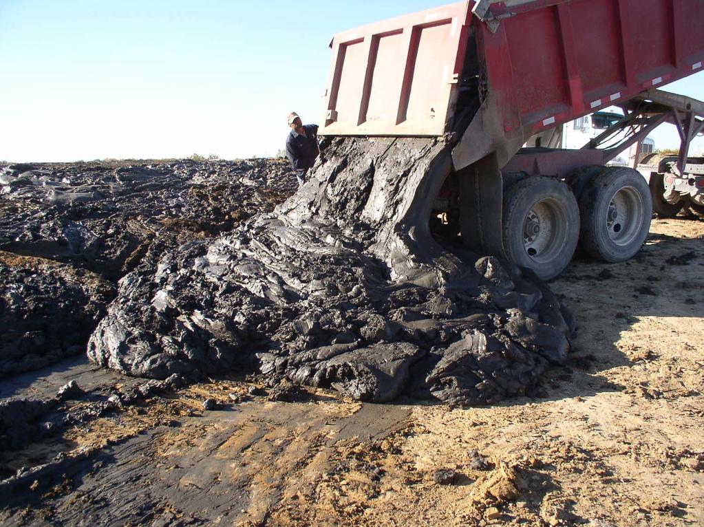
2 Reservoirs, river backwaters, and detention ponds are filling with sediment washed from land and stream banks. This destroys aquatic habitat, recreational potential and water supply functions. If a use can be found for the sediment, dredging to restore water depth becomes more feasible. Dredged material with suitable chemical and physical properties can provide needed topsoil at a variety of sites. This beneficial use can make dredging more economical as value is added at the restored site as well as the location receiving soil. It will also reduce the amount of soil taken from one area to benefit another.
3 Some Acknowledgements Dr. Robert Darmody Dr. Misganaw Demissie Richard Cahill Dr. Nani Bohwmik Jim Slowikowski DNR Field Staff and Site Managers Illinois river Coordinating Council Midwest Foundation Artco Fleeting Caterpillar Inc Kress Corp Brennan Marine Tricounty Regional Planning Commission
4 Beneficial Use as Soil can Restore economic and ecological values in aquatic systems Provide soil for restoration and remediation Reduce the need for taking soil from one area to benefit another
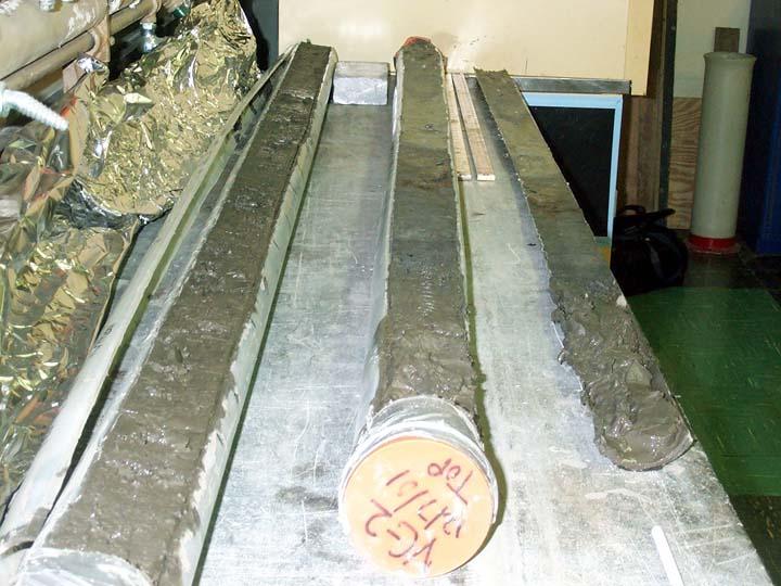
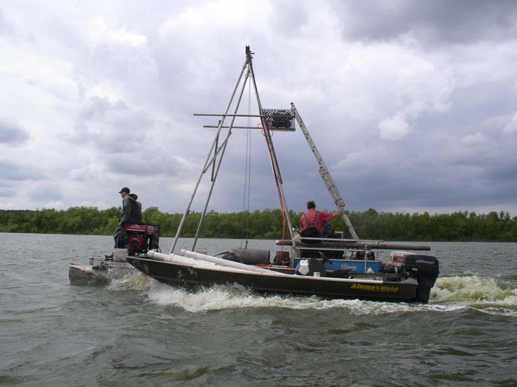
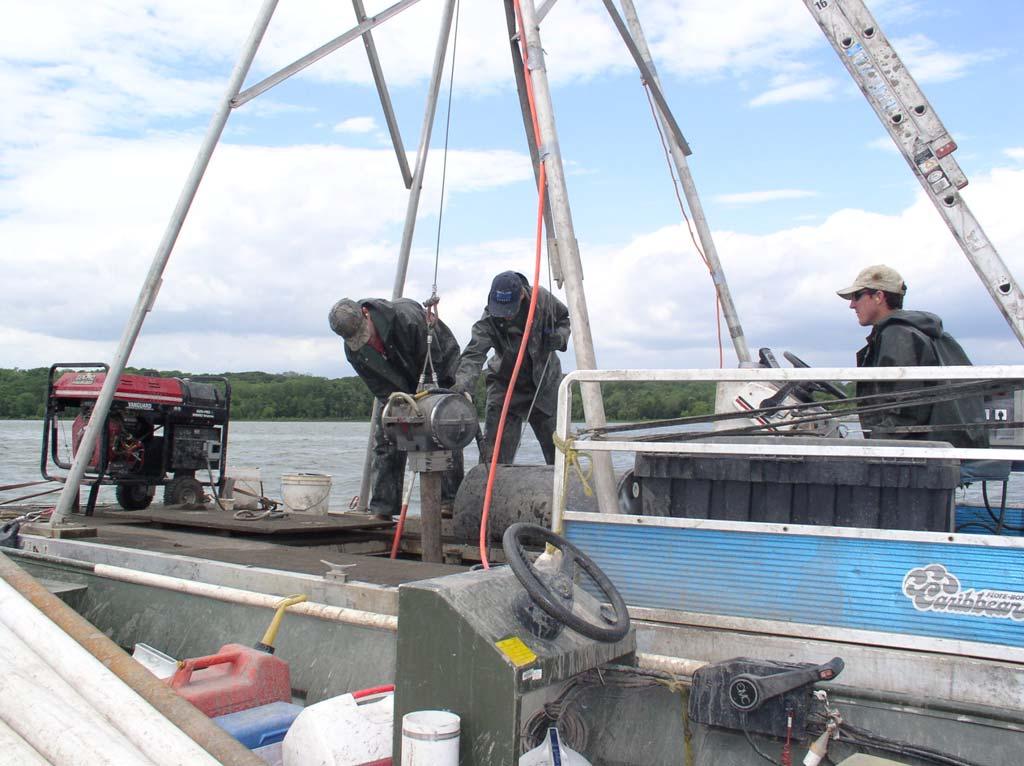
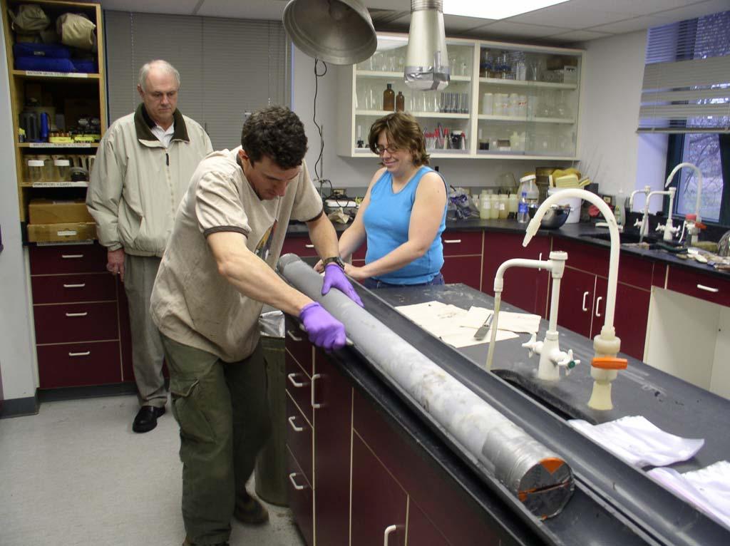
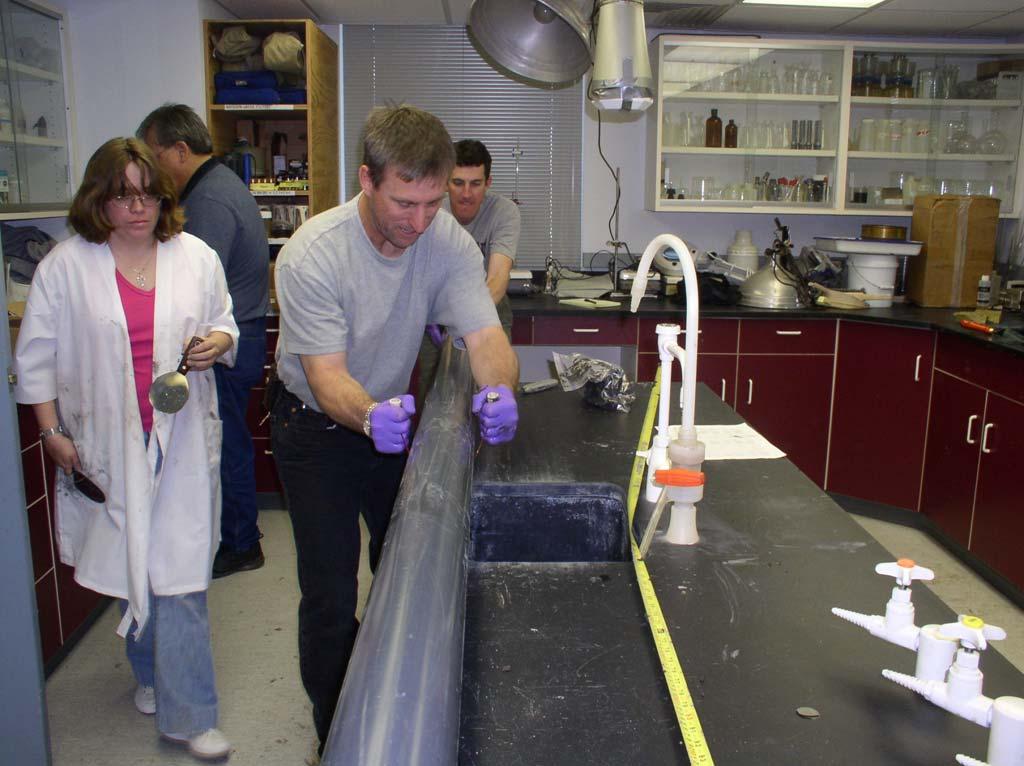
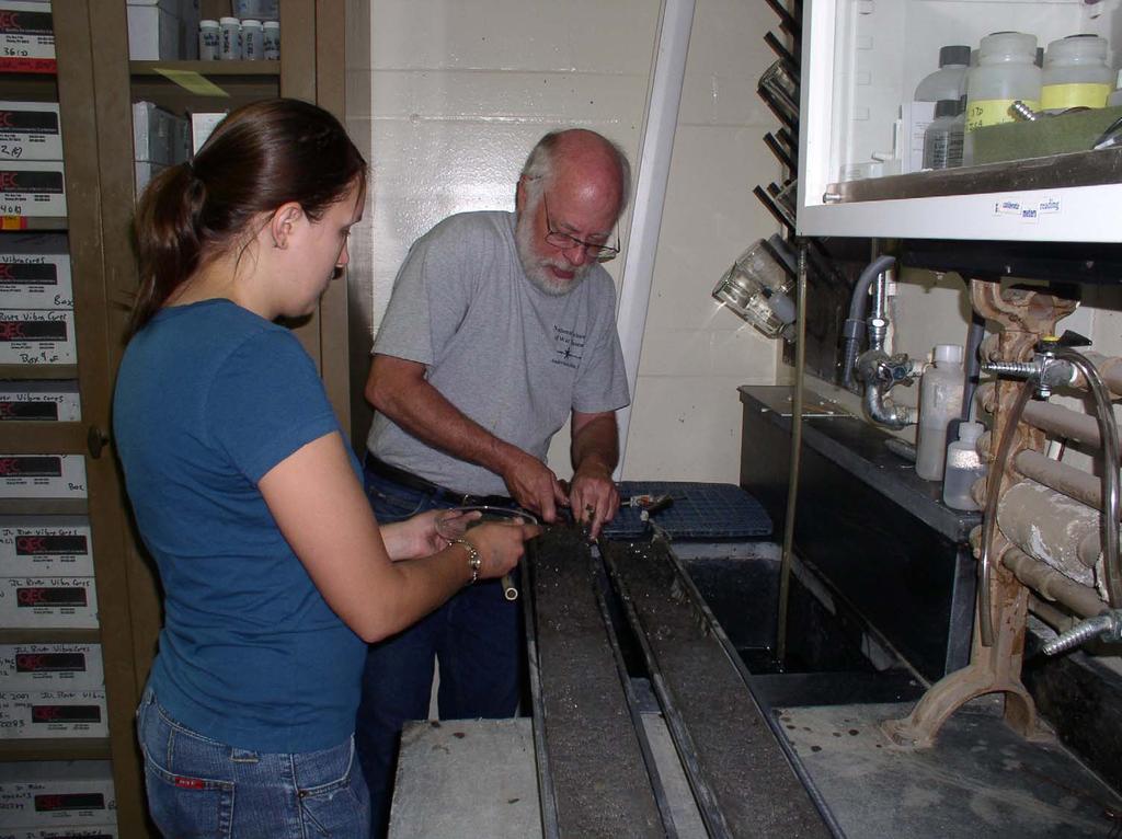
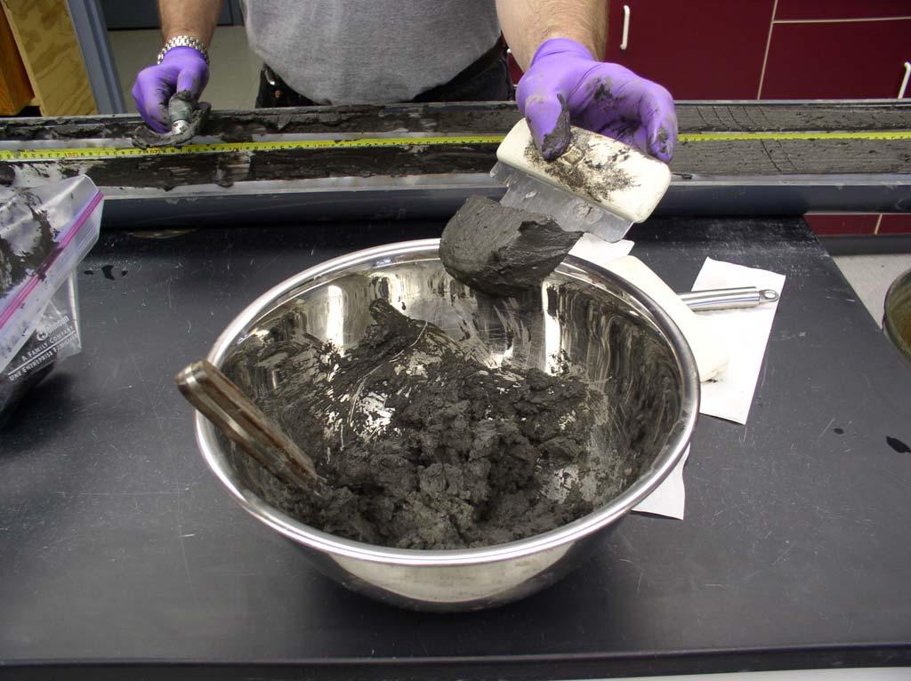
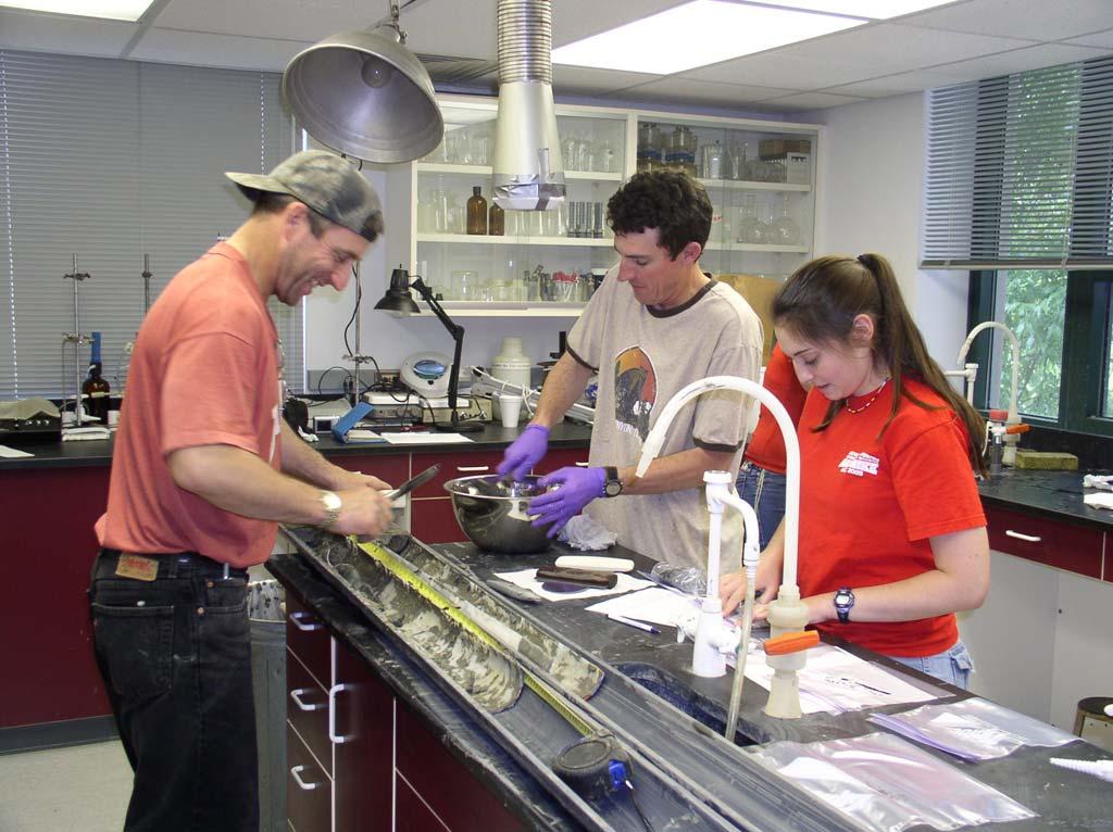
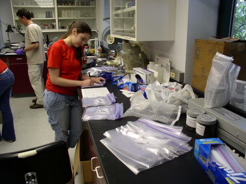
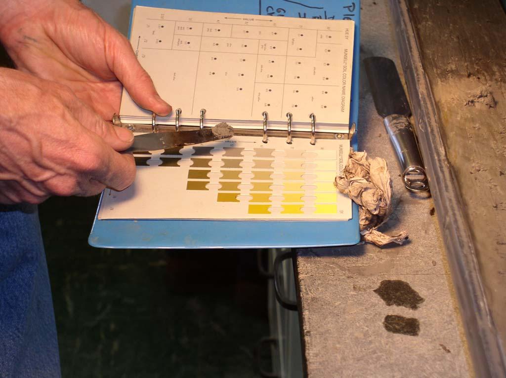
5 The Illinois State Water Survey operates a coring rig capable of penetrating ten feet of mud. The cores are carefully opened in a laboratory, photographed, and described. Slices are taken along the length for chemical analysis, fertility testing, agronomic characterization, and determination of various physical properties.
6
7

8

9
10
11 Evaluation of Sediment Cores Potential Chemical Contaminants Agronomic Fertility Soil Classification and Consistence Grain Size Moisture Content, Density, etc.
12
13

14
15

16

17

18

19
20
21
22
23

24
25 Cores collected from Putnam to Cass County have been analyzed and described. The following slides provide draft data on the properties of several cores. Collectively they illustrate the differences within individual locations as well as over the length of a core. These differences are due to such factors as the depth of water created by the diversion and dams, sedimentation rates, and discharge of chemical contaminants over the decades.
26


")
27 Upper and Lower Segments of Cores in Various Ill River Lakes Goose Lk.,. Fulton Co. 295a 0 38 cm 295c cm Lower Peoria Lk. Near Channel, River mile a 0 48 cm 195 f cm Sawyer Slough (lower end) Marshal Co. 277a 0 36 cm 277d cm


28 Six Segments of Core 384 from inside East Port Marina Lower Peoria Lk. 384a 0-34 cm 384c cm 384e cm 384f cm 384h cm 384j cm
29 Texture and Organic Matter of Sediment along East Port Channel in Lower Peoria Lake at Various Depths Approximate depth in cm Core 195 USDA Texture Core 197 USDA Texture Core 384 USDA texture Silty Clay Loam Silt Loam Silty Clay Silty Clay Loam Sandy Loam Peaty Silty Clay Loam Silty Clay Loam Clay Loam Silty Clay Loam Silty Clay Loam Silty Clay Organic matter content at various depths Core 195 Core 197 Core 384 Composite cm = 4.4% cm = 4.6% cm = 4.35 % cm = 5.3% cm = 49.7 % cm = 3.9% cm = 2.79 % cm = 1.9% cm = 3.21 %
30 Selected Physical and Agronomic Properties of Core 279 from Babb s Slough Depth cm consistence (feel) texture (feel) % sand (feel) moisture (% wet) organic matter % extractable P ppm paste Silt Loam (peaty) < paste Silty Clay Loam very friable Silty Clay friable Silty Clay Loam friable Sandy Loam core 279
31 Physical and Agronomic Properties of Core 277 from Babb s Slough Depth cm consistence (feel) texture (feel) % sand (feel) moisture (% wet) organic matter % extractable P ppm fluid Silty Clay Loam paste Silty Clay Loam very firm Silty Clay firm Silty Clay firm Clay Loam friable Clay Loam core 277
32 Contaminant Testing 24 metals 22 pesticides 7 PCB arachlors 72 semi volatile organics, including PAH
33 Concentration of Selected Chemicals in Sediment Cores from Various Backwater Lakes in Illinois (preliminary data) Chemical Arsenic mg/kg Lead mg/kg Zinc mg/kg Dieldrin ug/kg PCB 1254 ug/kg BAP ug/kg Wightman Lk. Lacon IL. Ill. River N=5 9.6 R R R <22 R 55.4 R R Babb Slough Lacon IL. Ill. River N=7 4.9 R R R < 12 R 25.9 R R Lower Peoria Lk. (East Port) Ill. River N=8 7.3 R R R < 22 R 91 R R Muscootin Bay Beardstown Ill. River N=3 5.0 R R R < 2.9 R < 28 R <56 R N= number of cores, R = range, core length varies from.7 to over 2 meters, * J values Sturgeon Bay, New Boston IL Miss. River N=5 6.2 R R R <6 R < 26 R 14.2 R *

34 Concentration of Selected Chemicals from Sediment Cores in Wightman Lake near Lacon Core / Chemical cm cm cm cm cm ISWS map Arsenic mg/kg Lead mg/kg Zinc mg/kg Dieldrin ug/kg PCB 1254 ug/kg BAP ug/kg <22 <17 <12 <6.6 <

35 Concentration of Selected Chemicals in Segments of Sediment Core 197 from East Port Channel, Lower Peoria Lake Core/ Chemical cm cm cm Arsenic mg/kg ISWS Map Lead mg/kg Zinc mg/kg Dieldrin ug/kg PCB 1254 ug/kg <16 <3.5 <22 78 <35 <44 BAP ug/kg
36 Sediment has been used as topsoil at several sites in Illinois including a strip mined area, three landfills, and two industrial sites converted to parks. The following slides show the placement of mud from the Illinois River at East Peoria on the Banner Marsh State Fish and Wildlife Area and the Pekin Landfill. Both sites experienced excellent plant growth on the sediment which was easily handled by conventional equipment.

37

38 July 22, 2004, Banner Marsh

39 August 17, 2004, Banner Marsh

40 March 18, 2005 Banner Marsh

41

42 June 22, 2006 Banner Marsh

43 July 7, 2007 Banner Marsh

44

45
46

47 Pekin Landfill October 2007

48

49 Pekin landfill August 2008 clay liner/sediment cap
50
51 Illinois Sustainable Technology Center: (click initiatives) Illinois River Decision Support System
BACKWATER RESTORATION OPPORTUNITIES: ILLINOIS RIVER. John C. Marlin
 BACKWATER RESTORATION OPPORTUNITIES: ILLINOIS RIVER John C. Marlin Waste Management and Research Center, Illinois Department of Natural Resources One E. Hazelwood Dr., Champaign, Illinois 61801 E-mail:
Beneficial Use of Illinois River Sediment for Agricultural and Landscaping Applications. John C. Marlin
 ISTC Reports Illinois Sustainable Technology Center Beneficial Use of Illinois River Sediment for Agricultural and Landscaping Applications John C. Marlin Illinois Sustainable Technology Center Robert
East Branch Grand Calumet River Great Lakes Legacy Act Sediment Remediation and Restoration Project
 East Branch Grand Calumet River Great Lakes Legacy Act Sediment Remediation and Restoration Project Jointly funded by the U.S. EPA Great Lakes Legacy Act, Indiana Department of Environmental Management
EAGLES NEST AND PIASA ISLANDS
 EAGLES NEST AND PIASA ISLANDS HABITAT REHABILITATION AND ENHANCEMENT PROJECT MADISON AND JERSEY COUNTIES, ILLINOIS ENVIRONMENTAL MANAGEMENT PROGRAM ST. LOUIS DISTRICT FACT SHEET I. LOCATION The proposed
Stickney Avenue Depositional Zone (SADZ) Investigation
 Investigation") The Ottawa River: A Report to the Community Stickney Avenue Depositional Zone (SADZ) Investigation May 22, 2007 Presented by: Scott Bell, P.E., BCEE (LimnoTech) Kelly Bensman (Hull & Associates) SADZ Location
The Ottawa River: A Report to the Community Stickney Avenue Depositional Zone (SADZ) Investigation May 22, 2007 Presented by: Scott Bell, P.E., BCEE (LimnoTech) Kelly Bensman (Hull & Associates) SADZ Location
Diagnostic Geomorphic Methods for Understanding Future Behavior of Lake Superior Streams What Have We Learned in Two Decades?
 Diagnostic Geomorphic Methods for Understanding Future Behavior of Lake Superior Streams What Have We Learned in Two Decades? Faith Fitzpatrick USGS WI Water Science Center, Middleton, WI fafitzpa@usgs.gov
January Submitted by: 2200 Commonwealth Blvd, Suite 300 Ann Arbor, MI Ph: Fax:
 BOARDMAN RIVER FEASIBILITY STUDY A Report on Boardman River Existing Sediment Chemistry Data January 2009 Submitted by: 2200 Commonwealth Blvd, Suite 300 Ann Arbor, MI 48105 Ph: 734-769-3004 Fax: 734-769-3164
Source Control Early Action Focused Feasibility Study
 Source Control Early Action Focused Feasibility Study Empirical Mass Balance Model Results or the Lower Passaic River Edward A. Garvey, PhD, PG Malcolm Pirnie, Inc. Remedial Options Workgroup Meeting June
Sediment Management in the Coastal Bays
 Sediment Management in the Coastal Bays Introduction Need for ecosystem view of sediment management in Coastal Bays Island loss and restoration Navigation needs Habitat Trade offs Living Shoreline Requirements
Heather Schlosser Army Corps of Engineers Coastal Studies Group August 28, 2008
 Got sand? Regional Sediment Management in Orange County Heather Schlosser Army Corps of Engineers Coastal Studies Group August 28, 2008 Regional Sediment Management Regional sediment management recognizes
ATTACHMENT A WEAVER BOTTOMS SEDIMENT BASIN MAINTENANCE PROJECT PROJECT REPORT SUMMARY (APRIL 7, 2014)
") ATTACHMENT A WEAVER BOTTOMS SEDIMENT BASIN MAINTENANCE PROJECT PROJECT REPORT SUMMARY (APRIL 7, 2014) PRE-PROJECT DREDGE MATERIAL SEDIMENT CORE AND BASELINE CONTAMINANT ANALYSIS PREPARED BY BRAUN INTERTEC
ATTACHMENT A WEAVER BOTTOMS SEDIMENT BASIN MAINTENANCE PROJECT PROJECT REPORT SUMMARY (APRIL 7, 2014) PRE-PROJECT DREDGE MATERIAL SEDIMENT CORE AND BASELINE CONTAMINANT ANALYSIS PREPARED BY BRAUN INTERTEC
Red River Levee Panel
 Red River Levee Panel Mississippi River Commission Monday, August 9, 2017 Red River Levees in LA & AR NONE along TX & OK Boarder Red River Levee Issues Caddo Levee Cherokee Park Authorization Bossier Levee
April 9, Phosphate Mining and Reclamation Overview
 April 9, 2012 Phosphate Mining and Reclamation Overview Business & Mission Mosaic produces the majority of the phosphate used by American farmers Employs approximately 7,000 people worldwide, 3,000 in
3.11 Floodplains Existing Conditions
 Other stormwater control practices may be needed to mitigate water quality impacts. In addition to detention facilities, other practices such as vegetated basins/buffers, infiltration basins, and bioswales
Long-Distance Pumping and Opportunities for Engineering with Nature
 Long-Distance Pumping and Opportunities for Engineering with Nature Tim Welp and Derek Wilson Tim Welp Research Hydraulic Engineer Coastal and Hydraulics Laboratory 23 October 2012 Engineering with Nature
A PRIMER ON DAM REMOVALS IN MICHIGAN. Joe Rathbun Michigan Dept. Environmental Quality
 A PRIMER ON DAM REMOVALS IN MICHIGAN Joe Rathbun Michigan Dept. Environmental Quality rathbunj@michigan.gov Talk Outline Michigan dam factoids Effects of dams Removing a dam Steps Potential stumbling blocks
State Water Survey Division SURFACE WATER SECTION
 State Water Survey Division SURFACE WATER SECTION AT THE UNIVERSITY OF ILLINOIS Illinois Department of Energy and Natural Resources SWS Miscellaneous Publication 88 SEDIMENTATION OF POOL 19 ON THE MISSISSIPPI
Influence of the Major Drainages to the Mississippi River and Implications for System Level Management
 Influence of the Major Drainages to the Mississippi River and Implications for System Level Management Brian M. Vosburg Geologist Louisiana Coastal Protection and Restoration Authority brian.vosburg@la.gov
How Do Human Impacts and Geomorphological Responses Vary with Spatial Scale in the Streams and Rivers of the Illinois Basin?
 How Do Human Impacts and Geomorphological Responses Vary with Spatial Scale in the Streams and Rivers of the Illinois Basin? Bruce Rhoads Department of Geography University of Illinois at Urbana-Champaign
Kootenai River Habitat Restoration Program Update
 Kootenai River Habitat Restoration Program Update Kootenai Tribe of Idaho Kootenai Valley Resource Initiative November 19, 2012 Bonners Ferry, Idaho Changes to Kootenai Basin Beaver trapping Floodplain
Fish Passage Studies III: Sediment Redistribution and Impact Analysis: Springborn Dam - Enfield, Connecticut
 University of Massachusetts Amherst ScholarWorks@UMass Amherst International Conference on Engineering and Ecohydrology for Fish Passage International Conference on Engineering and Ecohydrology for Fish
Subcommittee on Sedimentation Draft Sediment Analysis Guidelines for Dam Removal
 Subcommittee on Sedimentation Draft Sediment Analysis Guidelines for Dam Removal August 4, 2011 Jennifer Bountry, M.S., P.E. Tim Randle, M.S., P.E., D.WRE. Blair Greimann, Ph.D., P.E. Sedimentation and
Soil Map Polk County, Florida
 Soil Map Polk County, Florida 28 9' 21'' 28 8' 23'' 3113000 3113200 3113400 3113600 3113800 3114000 3114200 3114400 3114600 81 51' 19'' 81 51' 19'' 416000 416000 ± 416200 416200 68 416400 68 416400 7 13
Regional Sediment Management
 Regional Sediment Management Linda S. Lillycrop Program Manager Coastal Engineer US Army Engineer Research and Development Center Coastal and Hydraulics Laboratory Q AVG Coastal Resilience: The Environmental,
3. MARINE HABITAT RESTORATION
 Feasibility Study for Restoration of Titlow Lagoon Fish Passage South Puget Sound Salmon Enhancement Group 3. MARINE HABITAT RESTORATION Marine habitat restoration at Titlow Park could include restoration
Illinois State Water Survey Division
 Illinois State Water Survey Division SURFACE WATER SECTION SWS Contract Report 413 AT THE UNIVERSITY OF ILLINOIS SEDIMENTATION SURVEY OF DAWSON LAKE, MORAINE VIEW STATE PARK, MC LEAN COUNTY, ILLINOIS by
Aquatic Sediment Sampling and Analyses
 Aquatic Sediment Sampling and Analyses Richard B. Shepard, Ph.D. March 16, 2011 Introduction Collecting sediment samples for analysis of contaminants particularly in river systems is not just a matter
Estimating Remedial Volumes for a GLLA Project on the Milwaukee River
 Estimating Remedial Volumes for a GLLA Project on the Milwaukee River Mike Ciarlo, Jamie Beaver, Mike Powell, Jason Byler EA Engineering, Science, and Technology, Inc. Marsha Burzynski, William Fitzpatrick
Redwood City Harbor, California, Navigation Improvement Feasibility Study. Appendix D. Geotechnical Engineering. DRAFT April 2015
 1 Redwood City Harbor, California, Navigation Improvement Feasibility Study Appendix D Geotechnical Engineering DRAFT April 2015 2 Contents 1 Purposes of Report... 3 2 Background... 3 3 References and
Description DESCRIPTION
 DESCRIPTION The location of the Upper James Watershed is located in northeastern South Dakota as well as southeastern North Dakota. It includes the following counties located in North Dakota Barnes, Dickey,
Port of Kalama, 2013 TEMCO Berth Maintenance Dredging and In-water Flow-Lane Placement Project
 2014 WEDA ENVIRONMENTAL EXCELLENCE AWARDS Category: Navigation Dredging Port of Kalama, 2013 TEMCO Berth Maintenance Dredging and In-water Flow-Lane Placement Project Port of Kalama, Washington 18 April
PEORIA LAKE SEDIMENT INVESTIGATION
 SURFACE WATER SECTION AT THE UNIVERSITY OF ILLINOIS Illinois Department of Energy and Natural Resources SWS Contract Report 371 PEORIA LAKE SEDIMENT INVESTIGATION by Misganaw Demissie and Nani G. Bhowmik
Solutions to Flooding on Pescadero Creek Road
 Hydrology Hydraulics Geomorphology Design Field Services Photo courtesy Half Moon Bay Review Solutions to Flooding on Pescadero Creek Road Prepared for: San Mateo County Resource Conservation District
RANCHO de DOS PALMAS DAVIS, California, AC +/-
 RANCHO de DOS PALMAS DAVIS, California, 507.28 AC +/- Boundary Transmission Line Pond / Tank Well SCOTT STONE P: (530) 662-4094 sastone57@gmail.com 37874 County Road 28, Woodland, Ca. 95695 The information
Curriculum Links AS and A level Field Studies
 Equipment Includes Human Geography Coastal Management Students examine the conflicts that arise from coastal erosion and the options for coastal management. They investigate different types of coastal
Lake Sedimentation Survey of Siloam Springs State Park Lake, Adams County, Illinois
 Contract Report 567 Lake Sedimentation Survey of Siloam Springs State Park Lake, Adams County, Illinois by Richard L. Allgire Office of Sediment & Wetland Studies Prepared for the Illinois Department of
Dam Removal Analysis Guidelines for Sediment
 A review of: Dam Removal Analysis Guidelines for Sediment Joe Rathbun (Retired) rathbunj@sbcglobal.net Some Potential Sediment Issues Reservoir restoration Downstream water quality Downstream deposition
EVALUATION OF SEDIMENT REMOVAL OPTIONS AND BENEFICIAL USE OF DREDGED MATERIAL FOR ILLINOIS RIVER RESTORATION: PRELIMINARY REPORT
 EVALUATION OF SEDIMENT REMOVAL OPTIONS AND BENEFICIAL USE OF DREDGED MATERIAL FOR ILLINOIS RIVER RESTORATION: PRELIMINARY REPORT John C. Marlin 1 ABSTRACT The overall habitat quality of the Illinois River
Seagrass Transplantation & Environmental & Marine Consulting Services, Inc. Drew Campbell, Vice President & Lead Scientst.
 Indian River Lagoon Symposium Seagrass Transplantation & Project Considerations Environmental & Marine Consulting Services, Inc. Drew Campbell, Vice President & Lead Scientst March 26 th, 2013 Regulatory
CRUM RANCH AREA MAP YOLO COUNTY, California, AC +/-
 CRUM RANCH AREA MAP YOLO COUNTY, California, 235.59 AC +/- Map data 2016 Google Imagery 2016, CAPCOG, DigitalGlobe, Texas Orthoimagery Program, U.S. Geological Survey, USDA Farm Service Agency Boundary
Island Design. UMRS EMP Regional Workshop. Presentation for the
 Island Design Presentation for the UMRS EMP Regional Workshop by Jon Hendrickson Hydraulic Engineer Regional Technical Specialist, Water Quality and Habitat Restoration August 17 19, 2005 Project Delivery
Soil Map Boulder County Area, Colorado (Planet Blue Grass) Web Soil Survey National Cooperative Soil Survey
 Web Soil Survey National Cooperative Soil Survey") 475910 476000 476090 476180 476270 476360 105 16' 21'' W 476450 476540 476630 476720 476810 4453350 4453440 4453260 4453350 4453170 4453260 4453080 4453170 4453080 475820 475910 4452990 476000 476090 476180
475910 476000 476090 476180 476270 476360 105 16' 21'' W 476450 476540 476630 476720 476810 4453350 4453440 4453260 4453350 4453170 4453260 4453080 4453170 4453080 475820 475910 4452990 476000 476090 476180
Custom Soil Resource Report. Soil Map. Map projection: Web Mercator Corner coordinates: WGS84 Edge tics: UTM Zone 14N WGS84. Feet.
 Custom Soil Resource Report Soil Map 3188500 3188700 3188900 3189100 3189300 3189500 3189700 96 43' 30'' W 3188500 3188700 3188900 3189100 3189300 3189500 3189700 96 42' 11'' W 28 48' 59'' N 28 48' 59''
Overview of Methods. Terrestrial areas that are most important for conservation Conservation
 Overview of Methods The goal of the Western Lake Erie Coastal Conservation Vision project (WLECCV) is to define where we should be working locally to optimally achieve regional conservation impact. The
Limitation to qualitative stability indicators. the real world is a continuum, not a dichotomy ~ 100 % 30 % ~ 100 % ~ 40 %
 Stream Stability Assessment & BEHI Surveys Joe Rathbun MDEQ Water Resources Division rathbunj@michigan.gov 517--373 517 373--8868 Stability Stream can transport its water and sediment inputs without changing
March 13, 2015 Presented at the Western Dredging Association, Midwest Chapter Meeting March 11 13, 2015, Milwaukee, Wisconsin
 In Situ Stabilization/Solidification (ISS), Another Tool for Remediation of Contaminated Sediments Christopher A. Robb, PE Thomas J. degrood Richard H. Weber, PE Natural Resource Technology, Inc. March
Crows Landing Naval Base Easement
 1 of 15 West Stanislaus Resource Conservation District Crows Landing Naval Base Easement Annual Reserve Monitoring Report Jamie McFarlin 11/112012 2 of 15 West Stanislaus Resource Conservation District
Displayed with permission The American Surveyor Vol. 9 No. 8 Copyright 2012 Cheves Media
 Barr Engineering s John Novack pilots the vessel while Jim Staberg reviews readings from the Hypack software which merges data from the Odom sounder and Topcon HiPer Lite+ GPS. A Superior Effort Engineering
Appendix I. Dredged Volume Estimates. Draft Contractor Document: Subject to Continuing Agency Review
 Appendix I Dredged Volume Estimates Draft Contractor Document: Subject to Continuing Agency Review Interoffice Correspondence Date: April 6, 2007 To: L. Bossi (WHI) Copy: S. Thompson (WHI), B. Fidler (NNJ)
Surface Water Short Study Guide
 Name: Class: Date: Surface Water Short Study Guide Multiple Choice Identify the letter of the choice that best completes the statement or answers the question. 1. The three ways in which a stream carries
Home About Us Articles Press Releases Image Gallery Contact Us Media Kit Free Subscription 10/5/2006 5:56:35 PM
 Home About Us Articles Press Releases Image Gallery Contact Us Media Kit Free Subscription 10/5/2006 5:56:35 PM Industry Resources Industry Directory NASA Links Missions/Launches Calendar Human development
Web Soil Survey National Cooperative Soil Survey
 121 52' 18'' W Irrigated Capability Class Sutter County, California () 121 51' 49'' W 597600 597700 597800 597900 598000 598100 598200 39 6' 27'' N 39 6' 27'' N 39 5' 57'' N 4328400 4328500 4328600 4328700
Ecological Land Cover Classification For a Natural Resources Inventory in the Kansas City Region, USA
 Ecological Land Cover Classification For a Natural Resources Inventory in the Kansas City Region, USA by Applied Ecological Services, Inc. In cooperation with the Mid-America Regional Council 600 Broadway,
Grand Canyon Sediment Augmentation Study. Tim Randle, P.E. Manager, Sedimentation and River Hydraulics Group, Denver, Colorado
 Grand Canyon Sediment Augmentation Study Tim Randle, P.E. Manager, Sedimentation and River Hydraulics Group, Denver, Colorado Sediment Augmentation Objectives Seasonally increase turbidity to provide cover
Procedure for Determining Near-Surface Pollution Sensitivity
 Procedure for Determining Near-Surface Pollution Sensitivity Minnesota Department of Natural Resources Division of Ecological and Water Resources County Geologic Atlas Program March 2014 Version 2.1 I.
Implementing a Project with 319 Funds: The Spring Brook Meander Project. Leslie A. Berns
 Implementing a Project with 319 Funds: The Spring Brook Meander Project Leslie A. Berns "...to acquire... and hold lands... for the purpose of protecting and preserving the flora, fauna and scenic beauties...
Planning for the Future of Humboldt Bay: Sea Level Rise, Sediment Management, Sand Spits and Salt Marshes. Joel Gerwein
 Planning for the Future of Humboldt Bay: Sea Level Rise, Sediment Management, Sand Spits and Salt Marshes Joel Gerwein Introduction to Humboldt Bay Setting Economy, community, and environment Sediment
 Red River Flooding June 2015 Caddo and Bossier Parishes Presented by: Flood Technical Committee Where the Rain Falls Matters I-30 versus I-20 I-20 Backwater and Tributary Floods (Localized) 2016 Flood
Strategies for managing sediment in dams. Iwona Conlan Consultant to IKMP, MRCS
 Strategies for managing sediment in dams Iwona Conlan Consultant to IKMP, MRCS 1 Sediment trapping by dams Active storage capacity Dead storage coarse material (bed load) Fine materials (suspension) Francis
GEOG 1010 B. Come to the PASS workshop with your mock exam complete. During the workshop you can work with other students to review your work.
 It is most beneficial to you to write this mock midterm UNDER EXAM CONDITIONS. This means: Complete the midterm in 2 hours. Work on your own. Keep your notes and textbook closed. Attempt every question.
This is start of the single grain view
 SOIL TEXTURE, PARTICLE SIZE DISTRIBUTION, SPECIFIC SURFACE AND CLAY MINERALS We will assess the physical realm of soil science in a piecewise fashion starting with the physical phases of soil, -- a single
Weathering and Soil Formation. Chapter 10
 Weathering and Soil Formation Chapter 10 Old and New Mountains The Appalachian Mountains appear very different from the Sierra Mountains. The Appalachians are smaller, rounded, gently sloping, and covered
Shallow Karst Aquifer System of the Lake Belt Study Area, Miami-Dade County, Florida, USA EXTENDED ABSTRACT
 Second International Conference on Saltwater Intrusion and Coastal Aquifers Monitoring, Modeling, and Management. Merida, Mexico, March 30 April 2, 2003 Shallow Karst Aquifer System of the Lake Belt Study
ILLINOIS RIVER BASIN RESTORATION COMPREHENSIVE PLAN WITH INTEGRATED ENVIRONMENTAL ASSESSMENT APPENDIX B
 ILLINOIS RIVER BASIN RESTORATION COMPREHENSIVE PLAN WITH INTEGRATED ENVIRONMENTAL ASSESSMENT APPENDIX B SYSTEM ECOLOGY ILLINOIS RIVER BASIN RESTORATION COMPREHENSIVE PLAN WITH INTEGRATED ENVIRONMENTAL
Custom Soil Resource Report Soil Map
 78 10' 44'' W Custom Soil Resource Report Soil Map 78 9' 40'' W 40 37' 18'' N 738700 738800 738900 739000 739100 739200 739300 739400 739500 739600 739700 739800 739900 740000 740100 40 37' 18'' N 4499700
Studying Rocks and Soil
 Studying Rocks and Soil How do rocks form? Rocks Rock is found in nature. Rock is solid. It is nonliving matter. All rocks are made of one or more minerals. A mineral is a natural material that forms from
How & Where does infiltration work? Summary of Geologic History Constraints/benefits for different geologic units
 June 26, 2007: Low Impact Development 1 Associated Earth Sciences, Inc. Associated Earth Sciences, Inc. Presented by: Matthew A. Miller, PE April 24, 2012 How & Where does infiltration work? Summary of
Habitat Assessment. Peggy Compton UW-Extension Water Action Volunteers Program Coordinator
 Habitat Assessment Peggy Compton UW-Extension Water Action Volunteers Program Coordinator Adapted from a presentation by Jean Unmuth, Water Quality Biologist, WI DNR dnr.wi.gov www.uwex.edu erc.cals.wisc.edu
Swift Creek Sediment Management Action Plan (SCSMAP)
") Swift Creek Sediment Management Action Plan (SCSMAP) PHASE 3 PROJECT PLAN PROPOSAL Whatcom County Public Works Department 322 N. Commercial Street, Suite 210 Bellingham, WA 98225 (360) 676-6692 June 2013
Swift Creek Sediment Management Action Plan (SCSMAP) PHASE 3 PROJECT PLAN PROPOSAL Whatcom County Public Works Department 322 N. Commercial Street, Suite 210 Bellingham, WA 98225 (360) 676-6692 June 2013
THIN-LAYER PLACEMENT OF DREDGE MATERIAL FOR MARSH NOURISHMENT, RESOTRATION, AND RESPONSE TO SEA LEVEL RISE
 THIN-LAYER PLACEMENT OF DREDGE MATERIAL FOR MARSH NOURISHMENT, RESOTRATION, AND RESPONSE TO SEA LEVEL RISE Case studies and lesson learned regarding thin-layer deposition projects in Delaware, New Jersey,
BUNCOMBE COUNTY NORTH CAROLINA
 PROJECT SITE ² 0 0. 75 1. 5 LOCATION MAP MARCH 2018 2. 25 3 Mil es AID: PROJECT # 2018-01122 18.05301 Sheet 1 of 7 Sources: Esri, HERE, DeLorme, USGS, Intermap, INCREMENT P, NRCan, Esri Japan, METI, Esri
Chapter Five. Synopsis
 Chapter Five Synopsis .0 Proposed Level Assessments. Prioritization of Level Assessments. Recommended Level P Locations.3 Level RAPP Locations 5 & Mosley Creek & RA.0 Proposed Level Assessments Based on
Material Workshop. Galveston District 2012 Beneficial Use of Dredged. Material Workshop. Custodians of the Coast
 Galveston District 2012 Beneficial Use of Dredged Material Workshop Galveston District 2012 Beneficial Use of Dredged Material Workshop US Army Corps of Engineers BUILDING STRONG Welcome Opening Remarks
Custom Soil Resource Report Soil Map
 121 3' 56'' W Custom Soil Resource Report Soil Map 121 2' 49'' W 45 16' 39'' N 5013800 5014000 5014200 5014400 5014600 5014800 5015000 5015200 5015400 5015600 651800 652000 652200 652400 652600 652800
Environmental impact assessment study of the new offshore dumping sites for Šventoji port in Lithuania
 Environmental impact assessment study of the new offshore dumping sites for Šventoji port in Lithuania Introduction Summary In 2003 Lithuanian Ministry of Transport initiated the preparation of feasibility
Bathymetric and Sediment Survey of Atchison County Lake, Atchison County, Kansas
 Bathymetric and Sediment Survey of Atchison County Lake, Atchison County, Kansas Kansas Biological Survey Applied Science and Technology for Reservoir Assessment (ASTRA) Program Report 2010-04 (November
Bank Erosion and Morphology of the Kaskaskia River
 Bank Erosion and Morphology of the Kaskaskia River US Army Corps Of Engineers St. Louis District Fayette County Soil and Water Conservation District Team Partners : Carlyle Lake Ecosystem Partnership Vicinity
Stream Restoration and Environmental River Mechanics. Objectives. Pierre Y. Julien. 1. Peligre Dam in Haiti (deforestation)
") Stream Restoration and Environmental River Mechanics Pierre Y. Julien Malaysia 2004 Objectives Brief overview of environmental river mechanics and stream restoration: 1. Typical problems in environmental
Stream Restoration and Environmental River Mechanics Pierre Y. Julien Malaysia 2004 Objectives Brief overview of environmental river mechanics and stream restoration: 1. Typical problems in environmental
2012 Rainfall, Runoff, Water Level & Temperature Beebe Lake Wright County, MN (# )
") www.fixmylake.com 18029 83 rd Avenue North Maple Grove, MN 55311 mail@freshwatersci.com (651) 336-8696 2012 Rainfall, Runoff, Water Level & Temperature Beebe Lake Wright County, MN (#86-0023) Prepared
www.fixmylake.com 18029 83 rd Avenue North Maple Grove, MN 55311 mail@freshwatersci.com (651) 336-8696 2012 Rainfall, Runoff, Water Level & Temperature Beebe Lake Wright County, MN (#86-0023) Prepared
Sampling Sediment and Porewaterin the Lower Willamette River St. Helens, Oregon. Henning Larsen, R.G. Oregon Dept of Environmental Quality
 Sampling Sediment and Porewaterin the Lower Willamette River St. Helens, Oregon Henning Larsen, R.G. Oregon Dept of Environmental Quality Columbia River Scappoose Bay Former Pope and Talbot Wood Treatment
River Restoration and Rehabilitation. Pierre Y. Julien
 River Restoration and Rehabilitation Pierre Y. Julien Department of Civil and Environmental Engineering Colorado State University Fort Collins, Colorado River Mechanics and Sediment Transport Lima Peru
IN SITU SPECIFIC GRAVITY VS GRAIN SIZE: A BETTER METHOD TO ESTIMATE NEW WORK DREDGING PRODUCTION
 IN SITU SPECIFIC GRAVITY VS GRAIN SIZE: A BETTER METHOD TO ESTIMATE NEW WORK DREDGING PRODUCTION Nancy Case O Bourke, PE 1, Gregory L. Hartman, PE 2 and Paul Fuglevand, PE 3 ABSTRACT In-situ specific gravity
ΛTKINS. Applications of Regional Sediment Management Concepts in Texas Estuarine Restoration Projects. Riparian Workshop Fort Worth, October 17, 2012
 Juan C Moya, PhD., PG Coastal Planning and Restoration Applications of Regional Sediment Management Concepts in Texas Estuarine Restoration Projects Riparian Workshop Fort Worth, October 17, 2012 West
Instream Sediment Control Systems
 Instream Sediment Control Systems INSTREAM PRACTICES Photo 1 Photo 2 Modular sediment The information contained within this series of fact sheets deals only with the design of temporary instream sediment
Geomorphology Of The Chilliwack River Watershed Landform Mapping At North Cascades National Park Service Complex, Washington By National Park Service
 Geomorphology Of The Chilliwack River Watershed Landform Mapping At North Cascades National Park Service Complex, Washington By National Park Service READ ONLINE Snowshed contributions to the Nooksack
SILT FENCE EFFECTIVENESS
 SILT FENCE EFFECTIVENESS Michelle G. Holloway, Department of Earth Sciences, University of South Alabama, Mobile, AL 36688. E-mail: MLG@jaguar1.usouthal.edu. Sediment is the number one pollutant in Dog
Custom Soil Resource Report for Forrest County, Mississippi
 United States Department of Agriculture Natural Resources Conservation Service A product of the National Cooperative Soil Survey, a joint effort of the United States Department of Agriculture and other
GTU. Shantilal Shah Engineering College, Bhavnagar
 GTU Shantilal Shah Engineering College, Bhavnagar 2 Around 40,000 large reservoirs worldwide used for water supply, power generation, flood control etc. About 1 % of the total storage volume is lost annually
Sediment Conditions In Backwater Lakes Along The Illinois River - Phase 2. by.
 Department of Registration and Education Sediment Conditions In Backwater Lakes Along The Illinois River - Phase 2 by. Ming T. Lee, P.E. Associate Engineer and John B. Stall, P.E. Head, Hydrology Section
Earth Science, 10e. Edward J. Tarbuck & Frederick K. Lutgens
 Earth Science, 10e Edward J. Tarbuck & Frederick K. Lutgens Weathering, Soil, and Mass Wasting Chapter 3 Earth Science, 10e Stan Hatfield and Ken Pinzke Southwestern Illinois College Earth's external processes
Coarse Sediment Augmentation on Regulated Rivers. Scott McBain McBain & Trush, Inc.
 Coarse Sediment Augmentation on Regulated Rivers Scott McBain McBain & Trush, Inc. scott@mcbaintrush.com Components Some geomorphic and ecological considerations Conceptual approach at understanding augmentation
GALVESTON BAY RSM Moving toward an Integrated, Cooperative, and Holistic Approach to Estuarine Sediments
 GALVESTON BAY RSM Moving toward an Integrated, Cooperative, and Holistic Approach to Estuarine Sediments RAE Conference 2010 Larry A. Wise Moffatt & Nichol RSM is a system-based approach for collaboratively
Considerations for Mechanical Dredging, Hydraulic Dredging and Mechanical Dewatering of Sediments
 Considerations for Mechanical Dredging, Hydraulic Dredging and Mechanical Dewatering of Sediments Authors: Jerry Vetter & Eric Zeigler Contractor s Perspective Previous Dredging and Dewatering Projects
3.3 CLIMATE, GEOLOGY, TOPOGRAPHY, AND SOILS CLIMATE GEOLOGY TOPOGRAPHY
 3.3 CLIMATE, GEOLOGY, TOPOGRAPHY, AND SOILS This section describes the climate, geology, topography, and soil resource characteristics of the Yolo Bypass Wildlife Area (Wildlife Area). Agricultural soil
Clyde River Landslide
 Clyde River Landslide Department of Geology, Perkins Hall, University of Vermont, Burlington, VT 05405 Abstract: This paper investigates a landslide on the Clyde River in Newport, Vermont. The landslide
Web Soil Survey National Cooperative Soil Survey
 122 14' 27'' W () 122 13' 37'' W 40 8' 40'' N 564700 564800 564900 565000 565100 565200 565300 565400 565500 565600 565700 565800 40 8' 40'' N 4443400 4443500 4443600 4443700 4443800 4443900 4444000 4443400
Passive, Adsorbent-Based Sediment Pore Water Sampling
 Passive, Adsorbent-Based Sediment Pore Water Sampling 2013 NEMC August 5, 2013 Jim Whetzel Amplified Geochemical Imaging, LLC. (AGI) Special thanks to Kathy West, URS Corporation Ken Alepidis and Sean
Characterization of Contaminant and Biomass-Derived Organic Matter in Sediments from the Lower Passaic River, New Jersey, USA
 Characterization of Contaminant and Biomass-Derived Organic Matter in Sediments from the Lower Passaic River, New Jersey, USA Nicole M. Bujalski Michael A. Kruge Earth and Environmental Studies Department,
Introduction to the Hydrogeomorphic (HGM) Classification System
 Classification System") Introduction to the Hydrogeomorphic (HGM) Classification System Objectives The Student Will be Able to: Define the 7 HGM Classes List the 3 Parameters That Define HGM Classes List the Major Water Budget
Introduction to the Hydrogeomorphic (HGM) Classification System Objectives The Student Will be Able to: Define the 7 HGM Classes List the 3 Parameters That Define HGM Classes List the Major Water Budget
Fig 1. Steps in the EcoValue Project
 Assessing the Social and Economic Value of Ecosystem Services in the Northern Forest Region: A Geographic Information System (GIS) Approach to Landscape Valuation Principal Investigator(s): Dr. Matthew