Stickney Avenue Depositional Zone (SADZ) Investigation
|
|
|
- Luke Price
- 5 years ago
- Views:
Transcription
")

1 The Ottawa River: A Report to the Community Stickney Avenue Depositional Zone (SADZ) Investigation May 22, 2007 Presented by: Scott Bell, P.E., BCEE (LimnoTech) Kelly Bensman (Hull & Associates)

2 SADZ Location & Characteristics - Between RM 4.2 to the Stickney Avenue bridge RM Wide, relatively shallow, and slower moving section of the river - First major depositional zone downstream of the historic landfill section of the river
3 SADZ Previous Studies* Physical & hydraulic conditions in river favor sedimentation Relatively thick sediment layer with buried PCB impacts Conditions indicate that it may be feasible to manage contaminated sediments in place through capping and/or monitored natural recovery *(LimnoTech, 2001; Hull & Associates, 2004)

4 SADZ Physical Description


5 SADZ Backwater Area - Periodically inundated - Receives storm water runoff from nearby industrial and urban areas - Physical and chemical characteristics unknown
6 SADZ Project Scope Investigate sediment and hydrological characteristics Collect supplemental physical, chemical data to support remedial design Collect toxicity data to assist U.S. EPA in sediment toxicity evaluation Target investigation to fulfill the requirements of Great Lakes Legacy Act to position project for possible funding for remediation

 - Sediment Cores Collected")
7 SADZ Sediment Sampling - Completed Fall Sample locations identified based on previous data (Hull, BBL) - Sediment Cores Collected along 7 transects

8 Sample Collection Sediment Cores - Supplemental physical and chemical data to assist in remedial design - 27 sediment cores collected - Located along 7 transects ft. core lengths Surficial Sediment - Data to assist U.S. EPA in sediment toxicity evaluation - 10 samples collected - located along length of SADZ (RM 4.2 RM 4.9)

9 Sediment Core Sample Collection Cores processed on-shore Visual Characterization Color Sediment texture Relative organic content Presence of non-soil materials
10 Sediment Core Sample Collection 57 composite samples collected Chemical Analysis - PCBS, PAHs,, Lead, TOC Physical Analysis (10 samples) - Grainsize Distribution - Atterberg Limits - Natural Moisture Content - Specific Gravity
11 Sediment Grab Sample Collection 10 grab samples collected Chemical Chemical Analysis -AVS/SEM (acid volatile sulfides/simultaneously extracted metals): As, Cd,, Cr, Cu, Pb,, Hg, Ni, Zn -PAHs -TOC
12 PCBs Sediment Analytical Results Only Only 2 of the 7 arochlors analyzed were detected Arochlor Arochlor 1242 detected in 61% of samples Arochlor Arochlor 1254 detected in 63% of samples Total Total PCB concentrations ranged from ppm Results Results similar to historic sampling Highest Highest concentrations clustered near backwater area PCBs>1 PCBs>1 ppm (general accepted standard for remediation) located throughout the main channel


13 Sediment Analytical Results Surficial PCB Concentrations (mg/kg)
14 PAHs Sediment Analytical Results 1717 of the 18 PAHs analyzed detected in at least one sample PAHsPAHs detected in 74% of samples Total Total PAH concentrations ranged from ppm Highest Highest concentrations clustered near the upstream portion of the SADZ, near the Stickney Bridge Results Results similar to historic sampling
15 Lead Sediment Analytical Results Naturally occurring element in soil Detected in 100% of samples Lead Lead concentrations range from ppm Highest Highest concentrations clustered near backwater area Results Results similar to historic sampling
16 Sediment Analytical Results Geotechnical Physical Physical properties are variable Sediments vary from clays to sands Most Most sediments appear relatively fine-grained and contain some (clay/silt content) SADZ SADZ contains cohesive and non-cohesive sediments as characterized by predominance of clay/silt No No apparent relationship exists between sediment type and contaminant occurrence
17 Hydrodynamic Modeling Purpose: simulate extreme conditions to evaluate sediment stability Multiple computer models used: SADZ backwater area hydrology Used USEPA SWMM to simulate storm water flows Ottawa River Hydrodynamics Used large- scale model to simulate river conditions under a range of flows and Lake Erie seiche effects SADZ Hydrodynamics Used fine-scale model of SADZ to evaluate local conditions in SADZ


18 Hydrodynamic Modeling
19 Hydrodynamic Modeling Goals: To simulate river conditions under extreme conditions Interested in velocities and shear stresses, because they indicate the energy available to move sediment
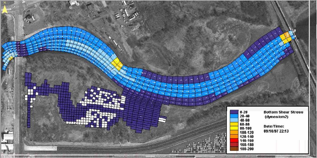
20 Hydrodynamic Modeling
21 Hydrodynamic Modeling Findings: Peak shear stresses during extreme hydrologic events may exceed threshold shear stresses of the sediments, which could result in downstream transport of contaminants. However, these peaks are infrequent, isolated, and of short duration.
22 Conclusions The effectiveness of monitored natural attenuation as the sole remediation alternative for the SADZ uncertain. The distribution of PCB impacts above 1 ppm throughout the SADZ indicates that dredging alone would likely involve sediment removal from almost the entire SADZ.
23 Conclusions An engineered cap may be feasible, if it is constructed of material that will withstand the peak shear stresses that can potentially develop in the SADZ A potentially feasible remedial alternative would include capping in potentially erosive areas, with monitored natural attenuation in the rest of the SADZ.
Sediment Stability in the Lower Passaic River Integration of Multiple Lines of Evidence
 Sediment Stability in the Lower Passaic River Integration of Multiple Lines of Evidence Fourth Passaic River Symposium June 22, 21 Michael Barbara, mab.consulting, LLC Marcia Greenblatt, AECOM John Connolly,
Estimating Remedial Volumes for a GLLA Project on the Milwaukee River
 Estimating Remedial Volumes for a GLLA Project on the Milwaukee River Mike Ciarlo, Jamie Beaver, Mike Powell, Jason Byler EA Engineering, Science, and Technology, Inc. Marsha Burzynski, William Fitzpatrick
Source Control Early Action Focused Feasibility Study
 Source Control Early Action Focused Feasibility Study Empirical Mass Balance Model Results or the Lower Passaic River Edward A. Garvey, PhD, PG Malcolm Pirnie, Inc. Remedial Options Workgroup Meeting June
Bishopville Prong Study
 Bathymetric and Sediment Assessment in the Bishopville Prong of St. Martin River Darlene V. Wells, Richard A. Ortt, Jr., and Stephen Van Ryswick Funded by MCBP 2011-2012 Implementation Grant Objectives
MEMORANDUM. Scott Pickard, CELRB-TD-EH Michael Asquith, CELRB-PM-PM. From: Paul R. Schroeder, Ph.D., PE Earl Hayter, Ph.D. Date: 14 March 2016
 DEPARTMENT OF THE ARMY ENGINEER RESEARCH AND DEVELOPMENT CENTER, CORPS OF ENGINEERS ENVIRONMENTAL LABORATORY WATERWAYS EXPERIMENT STATION, 3909 HALLS FERRY ROAD VICKSBURG, MISSISSIPPI 39180-6199 29 November
East Branch Grand Calumet River Great Lakes Legacy Act Sediment Remediation and Restoration Project
 East Branch Grand Calumet River Great Lakes Legacy Act Sediment Remediation and Restoration Project Jointly funded by the U.S. EPA Great Lakes Legacy Act, Indiana Department of Environmental Management
U.S. Army Corps of Engineers Detroit District. Sediment Trap Assessment Saginaw River, Michigan
 U.S. Army Corps of Engineers Detroit District December 2001 December 2001 This report has been prepared for USACE, Detroit District by: W.F. BAIRD & ASSOCIATES LTD. 2981 YARMOUTH GREENWAY MADISON, WISCONSIN
Illinois River Sediment Quality and Beneficial Use Options
 Illinois River Sediment Quality and Beneficial Use Options John C. Marlin Illinois Sustainable Technology Center Robert G. Darmody Dept. of Natural Resources and Environmental Science University of Illinois
Imagine the result Sediment Sampling Plan. 1½-Mile Reach of the Housatonic River. General Electric Company Pittsfield, Massachusetts
 Imagine the result General Electric Company Pittsfield, Massachusetts 2012 Sediment Sampling Plan 1½-Mile Reach of the Housatonic River March 2012 2012 Sediment Sampling Plan 1½-Mile Reach of the Housatonic
Variability in Geotechnical Properties of Sediments and Dredged Materials
 Variability in Geotechnical Properties of Sediments and Dredged Materials PURPOSE: This technical note provides an overview of selected uncertainties involved in estimating or characterizing pre-dredged
Decline of Lake Michigan-Huron Levels Caused by Erosion of the St. Clair River
 Decline of Lake Michigan-Huron Levels Caused by Erosion of the St. Clair River W.F. & Associates Coastal Engineers (in association with Frank Quinn) April 13, 2005 Outline Problem Definition Understanding
Old Stone Sewer Main Street
 Bangor Landing Bangor, Maine Case Study-Sediment Sediment Investigation Maine Department of Environmental Protection City of Bangor, with RMT, Inc. Site Location and Local Site Features 1 Bangor Landing
Sediment Traps. CAG Meeting May 21, 2012
 Sediment Traps CAG Meeting May 21, 2012 Agenda Background Fundamentals of Sediment Transport Sediment Trap Existing Information Next Steps 2 The Site Saginaw River 22 mile river beginning at confluence
Sediment Geotechnical Characterization Work Plan (Appendix C-2 to PDI WP)
") Sediment Geotechnical Characterization Work Plan (Appendix C-2 to PDI WP) Remedial Design Lower 8.3 Miles of the Lower Passaic River Operable Unit Two of the Diamond Alkali Superfund Site In and About
Sediment Geotechnical Characterization Work Plan (Appendix C-2 to PDI WP) Remedial Design Lower 8.3 Miles of the Lower Passaic River Operable Unit Two of the Diamond Alkali Superfund Site In and About
Appendix O. Sediment Transport Modelling Technical Memorandum
 Appendix O Sediment Transport Modelling Technical Memorandum w w w. b a i r d. c o m Baird o c e a n s engineering l a k e s design r i v e r s science w a t e r s h e d s construction Final Report Don
CONTAMINATED SEDIMENTS IN THE RHINE BASIN RELEVANT POLLUTANTS AND RESUSPENSION RISK. Martin Keller Federal Institute of Hydrology, Koblenz, Germany
 CONTAMINATED SEDIMENTS IN THE RHINE BASIN RELEVANT POLLUTANTS AND RESUSPENSION RISK Martin Keller Federal Institute of Hydrology, Koblenz, Germany CHR/ISI SEDIMENT WORKSHOP, Bern 27.-3.4.28 1 CONTAMINATED
Development and application of demonstration MIKE 21C morphological model for a bend in Mekong River
 Development and application of demonstration MIKE 21C morphological model for a bend in Mekong River September 2015 0 Table of Contents 1. Introduction... 2 2. Data collection... 3 2.1 Additional data...
Appendix I. Dredged Volume Estimates. Draft Contractor Document: Subject to Continuing Agency Review
 Appendix I Dredged Volume Estimates Draft Contractor Document: Subject to Continuing Agency Review Interoffice Correspondence Date: April 6, 2007 To: L. Bossi (WHI) Copy: S. Thompson (WHI), B. Fidler (NNJ)
B-1. Attachment B-1. Evaluation of AdH Model Simplifications in Conowingo Reservoir Sediment Transport Modeling
 Attachment B-1 Evaluation of AdH Model Simplifications in Conowingo Reservoir Sediment Transport Modeling 1 October 2012 Lower Susquehanna River Watershed Assessment Evaluation of AdH Model Simplifications
Dam Removal Analysis Guidelines for Sediment
 A review of: Dam Removal Analysis Guidelines for Sediment Joe Rathbun (Retired) rathbunj@sbcglobal.net Some Potential Sediment Issues Reservoir restoration Downstream water quality Downstream deposition
Environmental impact assessment study of the new offshore dumping sites for Šventoji port in Lithuania
 Environmental impact assessment study of the new offshore dumping sites for Šventoji port in Lithuania Introduction Summary In 2003 Lithuanian Ministry of Transport initiated the preparation of feasibility
Mississippi River West Bay Diversion Geomorphic Assessment and 1-D Modeling Plan
 Mississippi River West Bay Diversion Geomorphic Assessment and 1-D Modeling Plan Freddie Pinkard and Charlie Little Research Hydraulic Engineers ERDC-CHL-River Engineering Branch 27 February 2009 Lane
Overview of fluvial and geotechnical processes for TMDL assessment
 Overview of fluvial and geotechnical processes for TMDL assessment Christian F Lenhart, Assistant Prof, MSU Research Assoc., U of M Biosystems Engineering Fluvial processes in a glaciated landscape Martin
STRUCTURAL STABILITY ASSESSMENT
 STRUCTURAL STABILITY ASSESSMENT CFR 257.73(d) Bottom Ash Pond Complex Cardinal Plant Brilliant, Ohio October, 2016 Prepared for: Cardinal Operating Company Cardinal Plant Brilliant, Ohio Prepared by: Geotechnical
The Great Lakes Coalition is an organization of shoreline property owners on the Great Lakes dedicated to improving the quality of life for both it s
 The Great Lakes Coalition is an organization of shoreline property owners on the Great Lakes dedicated to improving the quality of life for both it s s membership and the public at large. Facts about Section
Sediment Transport Analysis for Stream Restoration Design: The Good, the Bad, and the Ugly.
 Sediment Transport Analysis for Stream Restoration Design: The Good, the Bad, and the Ugly. Brett Jordan Phd, PE HydroGeo Designs LLC. Land and Water Services Inc. THE GOOD THE BAD THE UGLY THE GOOD THE
March 13, 2015 Presented at the Western Dredging Association, Midwest Chapter Meeting March 11 13, 2015, Milwaukee, Wisconsin
 In Situ Stabilization/Solidification (ISS), Another Tool for Remediation of Contaminated Sediments Christopher A. Robb, PE Thomas J. degrood Richard H. Weber, PE Natural Resource Technology, Inc. March
Diego Burgos. Geology 394. Advisors: Dr. Prestegaard. Phillip Goodling
 Sediment Transport into an Urban Tributary Junction Diego Burgos Geology 394 Advisors: Dr. Prestegaard Phillip Goodling 1 Abstract Tributary junctions are an important component of stream morphology and
Table 5-1 Sampling Program Summary for Milltown Ford Avenue Redevelopment Area, NJ.
 Table 5- Sampling Program Summary for Milltown Ford Avenue Redevelopment Area, NJ. Transformer Pads (9 pads: PAD 9) Evaluate if PCBs presently exist in soils adjacent to, and/or beneath the transformer
A MULTI-CRITERIA APPROACH SUPPORTING THE INVESTIGATION OF A FLOODPLAIN POTENTIALLY CONTAMINATED BY PESTICIDES
 A MULTI-CRITERIA APPROACH SUPPORTING THE INVESTIGATION OF A FLOODPLAIN POTENTIALLY CONTAMINATED BY PESTICIDES L ZILIANI, B GROPPELLI, S CECCON, F COLOMBO (RAMBOLL ENVIRON) D BOCCHIOLA, M C RULLI, G RAVAZZANI,
From Monitoring to Measures: Historical Contaminated Sediments in the Elbe River Basin
 From Monitoring to Measures: Historical Contaminated Sediments in the Elbe River Basin Ulrich Förstner (TUHH), Susanne Heise (BIS) and Peter Heininger (BfG) 5th International SedNet Conference, Oslo 27th-29th
The process of determining the layers of natural soil deposits that will underlie a proposed structure and their physical properties is generally
 The process of determining the layers of natural soil deposits that will underlie a proposed structure and their physical properties is generally referred to as sub surface investigation 2 1 For proper
Run 028 (Note: error in UKC at start of exercise due incorrect tide input then corrected ok.)
") Run 027 RNZ Full Bridge Simulation Run Plots Final Report Be-Software August 2016 Prepared for Royal Haskoning DHV on behalf of Refining New Zealand Limited 27 Run 028 (Note: error in UKC at start of exercise
Run 027 RNZ Full Bridge Simulation Run Plots Final Report Be-Software August 2016 Prepared for Royal Haskoning DHV on behalf of Refining New Zealand Limited 27 Run 028 (Note: error in UKC at start of exercise
Geomorphology 5. Stream Sediment Stream Sediment
 Geomorphology 5. Stream Sediment 1 Name 47 Points LEARNING OUTCOMES 5. Stream Sediment By the end of this assignment you should be able to: Describe the relationship between particle size and critical
Fish Passage Studies III: Sediment Redistribution and Impact Analysis: Springborn Dam - Enfield, Connecticut
 University of Massachusetts Amherst ScholarWorks@UMass Amherst International Conference on Engineering and Ecohydrology for Fish Passage International Conference on Engineering and Ecohydrology for Fish
STUDY PERFORMANCE REPORT
 STUDY PERFORMANCE REPORT State: Michigan Project No.: F-80-R-8 Study No.: 230702 Title: Effects of sediment traps on Michigan river channels Period Covered: October 1, 2006 to September 30, 2007 Study
Sediment and Nutrient Mass Balance Model of ConowingoPool
 Sediment and Nutrient Mass Balance Model of ConowingoPool Mark Velleux and Jim Fitzpatrick HDR Engineering Chesapeake Bay Program Modeling Quarterly Review: August 10, 2016 Model Grid and Spatial Resolution
SASKATCHEWAN STRATIGRAPHY GLACIAL EXAMPLE BOULDERS IN GLACIAL DEPOSITS
 SASKATCHEWAN STRATIGRAPHY GLACIAL EXAMPLE BOULDERS IN GLACIAL DEPOSITS 51 SASKATCHEWAN STRATIGRAPHY GLACIAL SURFICIAL STRATIFIED DEPOSITS 52 SASKATCHEWAN STRATIGRAPHY GLACIAL EXAMPLE OF SEDIMENT DEPOSITION
Tom Ballestero University of New Hampshire. 1 May 2013
 Tom Ballestero University of New Hampshire 1 May 2013 1 Hydrology 2 Basic Hydrology Low flows most common Flows that fill the stream to the banks and higher are much less common Filling the stream to the
Soil Mechanics. Chapter # 1. Prepared By Mr. Ashok Kumar Lecturer in Civil Engineering Gpes Meham Rohtak INTRODUCTION TO SOIL MECHANICS AND ITS TYPES
 Soil Mechanics Chapter # 1 INTRODUCTION TO SOIL MECHANICS AND ITS TYPES Prepared By Mr. Ashok Kumar Lecturer in Civil Engineering Gpes Meham Rohtak Chapter Outlines Introduction to Soil Mechanics, Soil
H.1 SUMMARY OF SUBSURFACE STRATIGRAPHY AND MATERIAL PROPERTIES (DATA PACKAGE)
") DRAFT ONONDAGA LAKE CAPPING AND DREDGE AREA AND DEPTH INITIAL DESIGN SUBMITTAL H.1 SUMMARY OF SUBSURFACE STRATIGRAPHY AND MATERIAL PROPERTIES (DATA PACKAGE) Parsons P:\Honeywell -SYR\444576 2008 Capping\09
DRAFT ONONDAGA LAKE CAPPING AND DREDGE AREA AND DEPTH INITIAL DESIGN SUBMITTAL H.1 SUMMARY OF SUBSURFACE STRATIGRAPHY AND MATERIAL PROPERTIES (DATA PACKAGE) Parsons P:\Honeywell -SYR\444576 2008 Capping\09
(3) Sediment Movement Classes of sediment transported
 Sediment Movement Classes of sediment transported") (3) Sediment Movement Classes of sediment transported Dissolved load Suspended (and wash load ) Important for scouring algae Bedload (5-10% total load Moves along bed during floods Source of crushing for
(3) Sediment Movement Classes of sediment transported Dissolved load Suspended (and wash load ) Important for scouring algae Bedload (5-10% total load Moves along bed during floods Source of crushing for
Table of Contents Chapter 1 Introduction to Geotechnical Engineering 1.1 Geotechnical Engineering 1.2 The Unique Nature of Soil and Rock Materials
 Table of Contents Chapter 1 Introduction to Geotechnical Engineering 1.1 Geotechnical Engineering 1.2 The Unique Nature of Soil and Rock Materials 1.3 Scope of This Book 1.4 Historical Development of Geotechnical
Working with Natural Stream Systems
 Working with Natural Stream Systems Graydon Dutcher Delaware County Soil & Water Conservation District Stream Corridor Management Program Tropical Storm Sandy October 29,2012 What is a Watershed?
Technical Memorandum. To: From: Copies: Date: 10/19/2017. Subject: Project No.: Greg Laird, Courtney Moore. Kevin Pilgrim and Travis Stroth
 Technical Memorandum To: From: Greg Laird, Courtney Moore Kevin Pilgrim and Travis Stroth 5777 Central Avenue Suite 228 Boulder, CO 80301 www.otak.com Copies: [Electronic submittal] Date: 10/19/2017 Subject:
sedimentation Experimental design analysis applied to factors related to migration of sediment out of a stormwater catchbasin sump
 Humberto Avila and Robert Pitt Ph.D. Candidate, Department of Civil, Construction, and Environmental Engineering The University of Alabama P.O. Box 870205 Tuscaloosa, AL 35487 205-348-2895 E-mail: hfavilarangel@bama.ua.edu
GEOL 1121 Earth Processes and Environments
 GEOL 1121 Earth Processes and Environments Wondwosen Seyoum Department of Geology University of Georgia e-mail: seyoum@uga.edu G/G Bldg., Rm. No. 122 Seyoum, 2015 Chapter 6 Streams and Flooding Seyoum,
Two-Dimensional Simulation of Truckee River Hydrodynamics
 Two-Dimensional Simulation of Truckee River Hydrodynamics by Stephen H. Scott PURPOSE: The purpose of this Coastal and Hydraulics Engineering Technical Note (CHETN) is to demonstrate the use of multidimensional
ONONDAGA LAKE PRE-DESIGN INVESTIGATION: PHASE III WORK PLAN - ADDENDUM 2 Syracuse, New York
 ONONDAGA LAKE PRE-DESIGN INVESTIGATION: PHASE III WORK PLAN - Syracuse, New York Prepared For: 5000 Brittonfield Parkway Suite 700 East Syracuse, NY 13057 Prepared By: Parsons 290 Elwood Davis Road, Suite
Case Study: Sediment Contamination by Mercury and DDT and Ecological Risk Assessment for Aquatic Biota, Lake Maggiore, Italy
 Intersol March 19th, 2014 Case Study: Sediment Contamination by Mercury and DDT and Ecological Risk Assessment for Aquatic Biota, Lake Maggiore, Italy CO-AUTHORED BY E Bizzotto and F Colombo PRESENTED
Date of Report: EPA agreement number: Center Name and Institution of Ctr. Director: Identifier used by Center for Project: Title of Project:
 Date of Report: March 31, 2003 EPA agreement number: R829515C003 Center Name and Institution of Ctr. Director: Rocky Mountain Regional Hazardous Substance Research Center, Colorado State University, Fort
Statement of Impact and Objectives. Watershed Impacts. Watershed. Floodplain. Tumblin Creek Floodplain:
 Tumblin Creek Floodplain: Impacts Assessment and Conceptual Restoration Plan Casey A. Schmidt Statement of Impact and Objectives Urbanization has increased stormflow rate and volume and increased sediment,
MaxDepth Aquatics, Inc.
 MaxDepth Aquatics, Inc. Bathymetry of Mirror Pond From Newport Bridge to Galveston Bridge Prepared for the City of Bend By Joseph Eilers & Benn Eilers MaxDepth Aquatics, Inc. Bend, OR June 2005 INTRODUCTION
(3) Sediment Movement Classes of sediment transported
 Sediment Movement Classes of sediment transported") 9/17/15 (3) Sediment Movement Classes of sediment transported Dissolved load Suspended load Important for scouring algae Bedload (5-10% total load) Moves along bed during floods Source of crushing for
9/17/15 (3) Sediment Movement Classes of sediment transported Dissolved load Suspended load Important for scouring algae Bedload (5-10% total load) Moves along bed during floods Source of crushing for
UPSTREAM-DOWNSTREAM CONTAMINATION GRADIENT OF THE FLUVIAL URBAN SYSTEM IN CHENNAI (Tamil Nadu, India)
") UPSTREAM-DOWNSTREAM CONTAMINATION GRADIENT OF THE FLUVIAL URBAN SYSTEM IN CHENNAI (Tamil Nadu, India) Saravanan S.P. a,b, Desmet. M. a, Ambujam N.K. b, Thenmozhi D. b, Manikandabharath K. b, Rukkumany
UPSTREAM-DOWNSTREAM CONTAMINATION GRADIENT OF THE FLUVIAL URBAN SYSTEM IN CHENNAI (Tamil Nadu, India) Saravanan S.P. a,b, Desmet. M. a, Ambujam N.K. b, Thenmozhi D. b, Manikandabharath K. b, Rukkumany
Remaining Capacity in Great Lakes Reservoirs
 US Army Corps of Engineers Detroit District Remaining Capacity in Great Lakes Reservoirs Storage Capacity Behind Great Lakes Dams Field Data and Modeling Motivation for project Project overview Data and
Using Mathematical Models to Assess Sediment Stability
 Integrated Environmental Assessment and Management Volume 2, Number 1 pp. 44 50 44 Ó 2006 SETAC Using Mathematical Models to Assess Sediment Stability C Kirk Ziegler* Quantitative Environmental Analysis,
Sampling Sediment and Porewaterin the Lower Willamette River St. Helens, Oregon. Henning Larsen, R.G. Oregon Dept of Environmental Quality
 Sampling Sediment and Porewaterin the Lower Willamette River St. Helens, Oregon Henning Larsen, R.G. Oregon Dept of Environmental Quality Columbia River Scappoose Bay Former Pope and Talbot Wood Treatment
Tarbela Dam in Pakistan. Case study of reservoir sedimentation
 Tarbela Dam in Pakistan. HR Wallingford, Wallingford, UK Published in the proceedings of River Flow 2012, 5-7 September 2012 Abstract Reservoir sedimentation is a main concern in the Tarbela reservoir
Muck. Kevin Henderson, P.E. Evergreen Engineering, Inc. Presentation to Rivers Coalition 9/29/16
 Muck Kevin Henderson, P.E. Evergreen Engineering, Inc. Presentation to Rivers Coalition 9/29/16 LITERATURE REVIEW Schropp (1994) defined muck sediments as sediment with greater than 60% silts and clays,
COMPREHENSIVE ASSESSMENT OF CONTAMINATED FLUVIAL SEDIMENTS EROSION RISK AND ECOLOGICAL HAZARD
 COMPREHENSIVE ASSESSMENT OF CONTAMINATED FLUVIAL SEDIMENTS EROSION RISK AND ECOLOGICAL HAZARD INGO HAAG, ULRICH KERN and BERNHARD WESTRICH Institut für Wasserbau, Universität Stuttgart, 70550 Stuttgart,
Capping of contaminated seabed in Norway lessons learned
 Capping of contaminated seabed in Norway lessons learned Jens Laugesen, DNV GL, Hoevik, Norway Espen Eek, NGI, Oslo, Norway Jeanette Beckius and Erik Høygaard, Norwegian Environment Agency, Oslo, Norway
Solutions to Flooding on Pescadero Creek Road
 Hydrology Hydraulics Geomorphology Design Field Services Photo courtesy Half Moon Bay Review Solutions to Flooding on Pescadero Creek Road Prepared for: San Mateo County Resource Conservation District
Appendix G.19 Hatch Report Pacific NorthWest LNG Lelu Island LNG Maintenance Dredging at the Materials Offloading Facility
 Appendix G.19 Hatch Report Pacific NorthWest LNG Lelu Island LNG Maintenance Dredging at the Materials Offloading Facility Project Memo H345670 To: Capt. David Kyle From: O. Sayao/L. Absalonsen December
Rivers T. Perron
 1 Rivers T. Perron 12.001 After our discussions of large-scale topography, how we represent topography in maps, and how topography interacts with geologic structures, you should be frothing at the mouth
2015 Toxicity Testing of BEAR CREEK SEDIMENT
 2015 Toxicity Testing of BEAR CREEK SEDIMENT Sparrows Point Meeting Sollers Pt / Dundalk Public Library DECEMBER 16TH, 2015 LANCE YONKOS / SHARON HARTZELL PAST INVESTIGATIONS: 2004 Reported toxicity in
A. V T = 1 B. Ms = 1 C. Vs = 1 D. Vv = 1
 Geology and Soil Mechanics 55401 /1A (2002-2003) Mark the best answer on the multiple choice answer sheet. 1. Soil mechanics is the application of hydraulics, geology and mechanics to problems relating
Geology and Soil Mechanics /1A ( ) Mark the best answer on the multiple choice answer sheet.
 Mark the best answer on the multiple choice answer sheet.") Geology and Soil Mechanics 55401 /1A (2003-2004) Mark the best answer on the multiple choice answer sheet. 1. Soil mechanics is the application of hydraulics, geology and mechanics to problems relating
Geology and Soil Mechanics 55401 /1A (2003-2004) Mark the best answer on the multiple choice answer sheet. 1. Soil mechanics is the application of hydraulics, geology and mechanics to problems relating
Brief outline of the presentation
 EGS AGU - EUG Joint Assembly, Nice, France, April 2003 Session HS9 - Sediment dynamics and channel change in rivers and estuaries Channel change and sediment movement after a major level drawdown at Kremasta
L _*" I_
 -- @ o*.d 8 UNIVERSITY OF NEVADA-RENO ---^^_ lo-k L - - -- --- - _*" I lll-l-lllll Nevada Bureau of Fdlines and Goology LJriivrts~ly o: Nevada tierlo Ficnn, Novnda 8055 7 OORO (102) it34 6691 NEMG OPEN
7.3 Sediment Delivery Analysis
 7.3 Sediment Delivery Analysis In order to evaluate potential changes in sedimentation patterns that could occur due to impacts from the FCP and LPP alignments, sediment assessment models were constructed
Steven Noble MDEQ - WRD Enbridge Response Unit
 EPA situation report, October 19, 2012 Steven Noble MDEQ - WRD Enbridge Response Unit Brief history of the spill Monitoring Monitoring the impacts Follow the oil The Current Situation A Look at the Future
Sediment characteristics of Beaver Lake and implications for remediation; A Pilot Project.
 Sediment characteristics of Beaver Lake and implications for remediation; A Pilot Project. Delphine Faugeraux Leah Bendell A report to the Stanley Park Ecological Society. September 15 th 2011. Abstract
PROFESSIONAL SERVICES DESCRIPTION FOR THE POSITION OF:
 PROFESSIONAL SERVICES DESCRIPTION FOR THE POSITION OF: Paulsboro Marine Terminal Sediment and Benthic Sampling and Characterization Plan Addendum No. 1 SUBMISSION DEADLINE: May 27, 2009 at 11:00 A.M. FAIR
ATTACHMENT A WEAVER BOTTOMS SEDIMENT BASIN MAINTENANCE PROJECT PROJECT REPORT SUMMARY (APRIL 7, 2014)
") ATTACHMENT A WEAVER BOTTOMS SEDIMENT BASIN MAINTENANCE PROJECT PROJECT REPORT SUMMARY (APRIL 7, 2014) PRE-PROJECT DREDGE MATERIAL SEDIMENT CORE AND BASELINE CONTAMINANT ANALYSIS PREPARED BY BRAUN INTERTEC
ATTACHMENT A WEAVER BOTTOMS SEDIMENT BASIN MAINTENANCE PROJECT PROJECT REPORT SUMMARY (APRIL 7, 2014) PRE-PROJECT DREDGE MATERIAL SEDIMENT CORE AND BASELINE CONTAMINANT ANALYSIS PREPARED BY BRAUN INTERTEC
Do you think sediment transport is a concern?
 STREAM RESTORATION FRAMEWORK AND SEDIMENT TRANSPORT BASICS Pete Klingeman 1 What is Your Restoration Project Like? k? Do you think sediment transport is a concern? East Fork Lewis River, WA Tidal creek,
River Model (Delft3D)
") A Short River Model (Delft3D) & DIVERSION ANALYSIS presented by Nina J. Reins, PE, PhD, PMP State of the Coast May 30-June 1, 2018 Overview of Presentation Problem Statement & Background Analysis Key Findings
A Short River Model (Delft3D) & DIVERSION ANALYSIS presented by Nina J. Reins, PE, PhD, PMP State of the Coast May 30-June 1, 2018 Overview of Presentation Problem Statement & Background Analysis Key Findings
Erosion Rate is a Function of Erodibility and Excess Shear Stress = k ( o - c ) From Relation between Shear Stress and Erosion We Calculate c and
 From Relation between Shear Stress and Erosion We Calculate c and") Equilibrium, Shear Stress, Stream Power and Trends of Vertical Adjustment Andrew Simon USDA-ARS, Oxford, MS asimon@msa-oxford.ars.usda.gov Non-Cohesive versus Cohesive Materials Non-cohesive: sands and
Equilibrium, Shear Stress, Stream Power and Trends of Vertical Adjustment Andrew Simon USDA-ARS, Oxford, MS asimon@msa-oxford.ars.usda.gov Non-Cohesive versus Cohesive Materials Non-cohesive: sands and
Sediment Quality Improvements Through Science Based Management Actions
 Sediment Quality Improvements Through Science Based Management Actions Andrew Jirik, Port of Los Angeles James Vernon, Port of Long Beach May 30, 2014 Strategy Ports developed a 6 year program to develop
Results of a Sediment Survey in the Near Offshore Waters of the Proposed Quarry Site in the Vicinity of Whites Cove, Digby Neck, Nova Scotia
 Results of a Sediment Survey in the Near Offshore Waters of the Proposed Quarry Site in the Vicinity of Whites Cove, Digby Neck, Nova Scotia Prepared for Paul G. Buxton P.O. Box 98 Annapolis Royal, Nova
Open Channel Flow Part 2. Ch 10 Young, notes, handouts
 Open Channel Flow Part 2 Ch 10 Young, notes, handouts Uniform Channel Flow Many situations have a good approximation d(v,y,q)/dx=0 Uniform flow Look at extended Bernoulli equation Friction slope exactly
Annual transport rates at two locations on the fore-slope.
 Sediment Transport by Currents Fore-slope Sediment transport rates and sediment concentrations were computed from the hydrodynamic model runs as well as from direct measurements of current velocities at
DAM REMOVAL ENGINEERING ISSUES & OPTIONS
 DAM REMOVAL ENGINEERING ISSUES & OPTIONS Presented by: James G. Mac Broom, P.E. Milone & Mac Broom, Inc. October 2011 CLEAR GOALS and OBJECTIVES Fish Passage Habitat Defragmentation Water Quality Dam Failure
Appendix E. Phase 2A Geotechnical Data
 Appendix E Phase 2A Geotechnical Data Appendix E1 Geotechnical Testing of Sediment ApPENDIX El. GEOTECHNICAL TESTING OF SEDIMENT (Modified from Exponent, 20Q1c) E.I Introduction This appendix presents
Walnut Creek Sedimentation Study
 Walnut Creek Sedimentation Study January 10, 2012 Prepared for: U.S. Army Corps of Engineer Sacramento District 1325 J Street Sacramento, CA 95814-2922 Prepared by: Ronald R. Copeland, Ph.D., P.E. Mobile
Studia Geotechnica et Mechanica, Vol. XXXVI, No. 4, 2014 DOI: /sgem TECHNICAL NOTE
 Studia Geotechnica et Mechanica, Vol. XXXVI, No. 4, 2014 DOI: 10.2478/sgem-2014-0037 TECHNICAL NOTE STABILITY OF A LEVEE MADE OF BOTTOM SEDIMENTS FROM A DAM RESERVOIR KAROLINA KOŚ, EUGENIUSZ ZAWISZA Department
Considerations for Mechanical Dredging, Hydraulic Dredging and Mechanical Dewatering of Sediments
 Considerations for Mechanical Dredging, Hydraulic Dredging and Mechanical Dewatering of Sediments Authors: Jerry Vetter & Eric Zeigler Contractor s Perspective Previous Dredging and Dewatering Projects
11/12/2014. Running Water. Introduction. Water on Earth. The Hydrologic Cycle. Fluid Flow
 Introduction Mercury, Venus, Earth and Mars share a similar history, but Earth is the only terrestrial planet with abundant water! Mercury is too small and hot Venus has a runaway green house effect so
Lower Susquehanna River Integrated Sediment & Nutrient Monitoring Program
 Lower Susquehanna River Integrated Sediment & Nutrient Monitoring Program Presented at the Chesapeake Bay Program Scientific and Technical Advisory Committee (STAC) Workshop January 13, 2016 Background
Fluvial Processes In Dryland Rivers
 WILLIAM L. GRAF Fluvial Processes In Dryland Rivers Reprint of First Edition, Copyright 1988 Copyright 2002 by William L. Graf All rights reserved. No part of this book may be reproduced, stored in a retrieval
TECHNICAL SUPPORT FOR NY/NJ HARBOR ESTUARY PROGRAM USEPA REGION 2 TOXICS TMDL MODEL DEVELOPMENT. New York/New Jersey Harbor Estuary Program
 New York/New Jersey Harbor Estuary Program SEDIMENT AREA LOADING COMPONENT ANALYSIS AND SPREADSHEET TOOL DEVELOPMENT II HACKENSACK RIVER AND LOWER/RARITAN BAYS INTERPRETATIVE TECHNICAL MEMORANDUM TECHNICAL
A STUDY OF LOCAL SCOUR AT BRIDGE PIERS OF EL-MINIA
 A STUDY OF LOCAL SCOUR AT BRIDGE PIERS OF EL-MINIA Dr. Gamal A. Sallam 1 and Dr. Medhat Aziz 2 ABSTRACT Bridges are critical structures that require a substantial investment to construct and serve an important
Technical Memorandum No
 Pajaro River Watershed Study in association with Technical Memorandum No. 1.2.10 Task: Evaluation of Four Watershed Conditions - Sediment To: PRWFPA Staff Working Group Prepared by: Gregory Morris and
MINERALOGY AND CHEMISTRY OF MINE WASTE ROCK PILES IN MINING DISTRICTS IN SOUTHERN COLORADO AND NEW MEXICO
 MINERALOGY AND CHEMISTRY OF MINE WASTE ROCK PILES IN MINING DISTRICTS IN SOUTHERN COLORADO AND NEW MEXICO Virginia T. McLemore and Marcus Silva New Mexico Bureau of Geology and Mineral Resources, New Mexico
Griswold Creek August 22, 2013
 Creek August 22, 2013 1 Lake Erie Protection Fund Creek Study ver Evaluate the overall condition of Creek Determine stable channel dimensions & appropriate restoration techniques Starting Stat gpoint for
Appendix G.18 Hatch Report Pacific NorthWest LNG Lelu Island LNG Potential Impacts of the Marine Structures on the Hydrodynamics and Sedimentation
 Appendix G.18 Hatch Report Pacific NorthWest LNG Lelu Island LNG Potential Impacts of the Marine Structures on the Hydrodynamics and Sedimentation Patterns Project Memo H345670 To: Capt. David Kyle From:
Temporal variability of partially-contaminated sediments in a strongly regulated reservoir of the upper Rhine River
 Temporal variability of partially-contaminated sediments in a strongly regulated reservoir of the upper Rhine River Germain Antoine 1,2,, Thomas Pretet 1,3,, Matthieu Secher 3,, and Anne Clutier 3, 1 Laboratoire
IN SITU SPECIFIC GRAVITY VS GRAIN SIZE: A BETTER METHOD TO ESTIMATE NEW WORK DREDGING PRODUCTION
 IN SITU SPECIFIC GRAVITY VS GRAIN SIZE: A BETTER METHOD TO ESTIMATE NEW WORK DREDGING PRODUCTION Nancy Case O Bourke, PE 1, Gregory L. Hartman, PE 2 and Paul Fuglevand, PE 3 ABSTRACT In-situ specific gravity
Introduction to Soil Mechanics Geotechnical Engineering-II
 Introduction to Soil Mechanics Geotechnical Engineering-II ground SIVA Dr. Attaullah Shah 1 Soil Formation Soil derives from Latin word Solum having same meanings as our modern world. From Geologist point
Wetland & Floodplain Functional Assessments and Mapping To Protect and Restore Riverine Systems in Vermont. Mike Kline and Laura Lapierre Vermont DEC
 Wetland & Floodplain Functional Assessments and Mapping To Protect and Restore Riverine Systems in Vermont Mike Kline and Laura Lapierre Vermont DEC NWI+ Hydro-Geomorphic Characterization of Wetlands and