Muck. Kevin Henderson, P.E. Evergreen Engineering, Inc. Presentation to Rivers Coalition 9/29/16
|
|
|
- Coral Richards
- 5 years ago
- Views:
Transcription
1 Muck Kevin Henderson, P.E. Evergreen Engineering, Inc. Presentation to Rivers Coalition 9/29/16
2
3
4 LITERATURE REVIEW Schropp (1994) defined muck sediments as sediment with greater than 60% silts and clays, greater than 6% total organic carbon, and greater than 75% water. This definition is as useful as any in the literature. Organic content of muck sediments in SLR have been reported over 60%. Our experimental results were more 10-15%. Variance is due to Loss on Ignition lab test. Aluminum concentrations average 4-5 times higher in the St. Lucie sediments than in the 1987 IRL muck data provided by Trefry. Total nutrient concentrations were not as high as previously reported. SLR muck sediments average 0.26% TN and 1% TP Muck sediments naturally accumulate in estuaries like the St. Lucie. Past studies in the North Fork, and comparisons between 1884 and 1984 bathymetry, indicate deep muck sediments pre-date any impacts by man on the River basin.
5

6
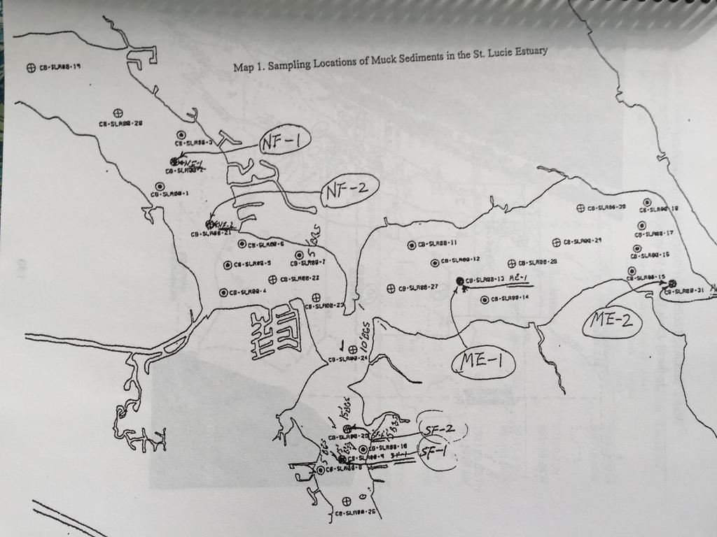
7 WHERE IT COMES FROM the organic fraction derives from uplands, as does the mineral fraction. The muck is essentially pine flatwoods soil hardpan, less the sand content. The sediment samples reported do not include the flocculent sediment layer which floats over the more (at least semi-) consolidated sediments. This flocculent layer is suspected a source of the rapid increase in turbidity observed in the Estuary in response to normal wind shear. Early investigations of complaints of excessive turbidity in the estuary conducted by the Army Corps of Engineers and USGS in the late 50 s concluded that fine flocculent sediments were flushed out of the River and into the Ocean by freshwater inflows and tidal exchanges. More recent studies, and re-interpretations of older data, indicate that fine flocculent sediments are also effectively trapped in the Estuary by the complex interaction of fresh and salt waters, and tidal movements. See Woodward-Clyde (1998) for an excellent summary of these processes.
8 TOXCICITY Trefry reports (1993b) concentrations of Polynuclear Aromatic Hydrocarbons (PAH) between 15 and 30 ppb are found in fine organic-rich sediments in Crane Creek, Turkey Creek, and Manatee Pocket. These are all locations where significant harbor activities have been located for many decades. The reported concentrations are high enough to have potential biological effects, but not high enough to be a disposal issue for dredge spoil. None of these concentrations of metals are toxic or hazardous according to the various published federal or state standards. At the same time, however, there is evidence that some sediments within the Estuary exert adverse effects on benthic biota.
9
10
11
12
13
14
15 BENEFICIAL USES No cost-effective beneficial uses Disposal Dewatering is a major obstacle to any use, including simple upland disposal The most important aspect of simple disposal is availability of an uplands impoundment site large enough to contain the quantity of material being dredged without additional treatment or manipulation within the impoundment site.
16 PROJECT CONCLUSIONS Muck sediments in the St. Lucie Estuary originate in uplands within the watershed. Muck sediment composition, both mineral and organic content, is very similar to the hardpan soils layer found in the pine flatwoods landform that makes up a majority of the estuarine watershed. St. Lucie muck sediments are very similar to those found in other low energy tidal estuaries along the Indian River Lagoon. Muck sediment accumulation rates were historically less than 10% of rates measured since significant anthropogenic modifications to the watershed began, less than 200 years ago. Large areas of muck sediments in the wide North and South Forks and the Middle Estuary exceed 15 in depth. Toxic and/or hazardous characteristics of St. Lucie muck sediments are below state and federal standards for toxic and/or hazardous classification. Metals, PCB s, PAH s and pesticides concentrations are not an obstacle with respect to potential beneficial uses. Cost-effective beneficial uses of St. Lucie muck sediments remain to be identified, and there may be none. Final dredge design should consider shape and location of sediment traps excavated into the deepest deposits of muck for control of turbidity in the Estuary, rather than attempting to remove loose surface layers from shallow areas. Final muck disposal should focus on simple upland containment as the least cost disposal alternative. Potential beneficial uses are affected by the Upland Disposal Site design.
17 Questions? THE END
Subtidal permanently flooded with tidal water. Irregularly exposed surface exposed by tides less often than daily
 Types of Wetlands Tidal Systems COASTAL WETLAND ECOSYSTEMS Tidal Salt Marshes Tidal Freshwater Marshes Mangrove Wetlands Tidal Estuarine Wetland 1 Definition and Formation of Estuaries u Estuary : partially
Types of Wetlands. Tidal Systems
 Types of Wetlands Tidal Systems 1 COASTAL WETLAND ECOSYSTEMS Tidal Salt Marshes Tidal Freshwater Marshes Mangrove Wetlands 2 Tidal Estuarine Wetland 3 Definition and Formation of Estuaries Estuary: : partially
Appendix E: Cowardin Classification Coding System
 Appendix E: Cowardin Classification Coding System The following summarizes the Cowardin classification coding system and the letters and numbers used to define the USFWS NWI wetland types and subtypes:
Sediment Traps. CAG Meeting May 21, 2012
 Sediment Traps CAG Meeting May 21, 2012 Agenda Background Fundamentals of Sediment Transport Sediment Trap Existing Information Next Steps 2 The Site Saginaw River 22 mile river beginning at confluence
Dynamics of the Ems Estuary
 Dynamics of the Ems Estuary Physics of coastal systems Jerker Menninga 0439738 Utrecht University Institute for Marine and Atmospheric research Utrecht Lecturer: Prof. dr. H.E. de Swart Abstract During
SEDIMENT TRANSPORT IN RIVER MOUTH ESTUARY
 SEDIMENT TRANSPORT IN RIVER MOUTH ESTUARY Katsuhide YOKOYAMA, Dr.Eng. dredge Assistant Professor Department of Civil Engineering Tokyo Metropolitan University 1-1 Minami-Osawa Osawa, Hachioji,, Tokyo,
Bell Ringer. water cycle? gaseous water (water vapor)? How do you know? 1. What are the five components of the
? How do you know? 1. What are the five components of the") Bell Ringer 1. What are the five components of the water cycle? 2. Are clouds composed of liquid water or gaseous water (water vapor)? How do you know? 3. How are glaciers formed? Salt Water - Oceans Characteristics
Bell Ringer 1. What are the five components of the water cycle? 2. Are clouds composed of liquid water or gaseous water (water vapor)? How do you know? 3. How are glaciers formed? Salt Water - Oceans Characteristics
Bishopville Prong Study
 Bathymetric and Sediment Assessment in the Bishopville Prong of St. Martin River Darlene V. Wells, Richard A. Ortt, Jr., and Stephen Van Ryswick Funded by MCBP 2011-2012 Implementation Grant Objectives
Lower Passaic River Restoration Project/ Newark Bay Study Project Delivery Team (PDT) Meeting March 5, 2008 from 1:00 3:00 PM
 Meeting March 5, 2008 from 1:00 3:00 PM") Lower Passaic River Restoration Project/ Newark Bay Study Project Delivery Team (PDT) Meeting March 5, 2008 from 1:00 3:00 PM Location: Participants: No. Jersey Transportation Planning Auth (NJTPA), 1
Lower Passaic River Restoration Project/ Newark Bay Study Project Delivery Team (PDT) Meeting March 5, 2008 from 1:00 3:00 PM Location: Participants: No. Jersey Transportation Planning Auth (NJTPA), 1
Fish Passage Studies III: Sediment Redistribution and Impact Analysis: Springborn Dam - Enfield, Connecticut
 University of Massachusetts Amherst ScholarWorks@UMass Amherst International Conference on Engineering and Ecohydrology for Fish Passage International Conference on Engineering and Ecohydrology for Fish
B-1. Attachment B-1. Evaluation of AdH Model Simplifications in Conowingo Reservoir Sediment Transport Modeling
 Attachment B-1 Evaluation of AdH Model Simplifications in Conowingo Reservoir Sediment Transport Modeling 1 October 2012 Lower Susquehanna River Watershed Assessment Evaluation of AdH Model Simplifications
Planning for the Future of Humboldt Bay: Sea Level Rise, Sediment Management, Sand Spits and Salt Marshes. Joel Gerwein
 Planning for the Future of Humboldt Bay: Sea Level Rise, Sediment Management, Sand Spits and Salt Marshes Joel Gerwein Introduction to Humboldt Bay Setting Economy, community, and environment Sediment
Sediments in a changing Environment Ecological implications of dredging and relocation in the Elbe estuary Günther Eichweber, WSD-Nord
 Sediments in a changing Environment Ecological implications of dredging and relocation in the Elbe estuary Günther Eichweber, WSD-Nord 2011-04-07 S1 Basic problem: sediment budget out of equilibrium 2011-04-07
Physiography Ocean Provinces p. 1 Dimensions p. 1 Physiographic Provinces p. 2 Continental Margin Province p. 2 Deep-Ocean Basin Province p.
 Physiography Ocean Provinces p. 1 Dimensions p. 1 Physiographic Provinces p. 2 Continental Margin Province p. 2 Deep-Ocean Basin Province p. 2 Mid-Ocean Ridge Province p. 3 Benthic and Pelagic Provinces
PART 4 GEOLOGIC SETTING AND FOUNDATION CONDITIONS IN NEW ORLEANS
 PART 4 GEOLOGIC SETTING AND FOUNDATION CONDITIONS IN NEW ORLEANS The modern Mississippi Delta has been deposited during the past 6000 years, in four major areas. Current interpretation of the modern delta.
Aquatic Sediment Sampling and Analyses
 Aquatic Sediment Sampling and Analyses Richard B. Shepard, Ph.D. March 16, 2011 Introduction Collecting sediment samples for analysis of contaminants particularly in river systems is not just a matter
Remaining Capacity in Great Lakes Reservoirs
 US Army Corps of Engineers Detroit District Remaining Capacity in Great Lakes Reservoirs Storage Capacity Behind Great Lakes Dams Field Data and Modeling Motivation for project Project overview Data and
MEMORANDUM. Scott Pickard, CELRB-TD-EH Michael Asquith, CELRB-PM-PM. From: Paul R. Schroeder, Ph.D., PE Earl Hayter, Ph.D. Date: 14 March 2016
 DEPARTMENT OF THE ARMY ENGINEER RESEARCH AND DEVELOPMENT CENTER, CORPS OF ENGINEERS ENVIRONMENTAL LABORATORY WATERWAYS EXPERIMENT STATION, 3909 HALLS FERRY ROAD VICKSBURG, MISSISSIPPI 39180-6199 29 November
Coastal and Marine Ecological Classification Standard (CMECS)
") Coastal and Marine Ecological Classification Standard (CMECS) Kathy Goodin, NatureServe EMECS, August 2011 Baltimore, MD 1 Outline Objectives & Process Classification Content Questions 2 Objectives Develop
Coastal and Marine Ecological Classification Standard (CMECS) Kathy Goodin, NatureServe EMECS, August 2011 Baltimore, MD 1 Outline Objectives & Process Classification Content Questions 2 Objectives Develop
Depositional Environment
 Depositional Environment Sedimentary depositional environment describes the combination of physical, chemical and biological processes associated with the deposition of a particular type of sediment. Types
MaxDepth Aquatics, Inc.
 MaxDepth Aquatics, Inc. Bathymetry of Mirror Pond From Newport Bridge to Galveston Bridge Prepared for the City of Bend By Joseph Eilers & Benn Eilers MaxDepth Aquatics, Inc. Bend, OR June 2005 INTRODUCTION
Reading Material. See class website. Sediments, from Oceanography M.G. Gross, Prentice-Hall
 Reading Material See class website Sediments, from Oceanography M.G. Gross, Prentice-Hall Materials filling ocean basins Dissolved chemicals especially from rivers and mid-ocean ridges (volcanic eruptions)
Sediment and sedimentary rocks Sediment
 Sediment and sedimentary rocks Sediment From sediments to sedimentary rocks (transportation, deposition, preservation and lithification) Types of sedimentary rocks (clastic, chemical and organic) Sedimentary
Carbon Sequestration Potential from Coastal Wetlands Restoration Sites
 Carbon Sequestration Potential from Coastal Wetlands Restoration Sites Insert then choose Picture select your picture. Right click your picture and Send to back. Paul Krause, Alyssa Beach Emily Cooper,
Session: For more information:
 Session: For more information: www.hydropower.org/congress San Juan, Puerto Rico www.glmengineers.com 2015 World Hydropower Congress Sustainable Sediment Management and Hydropower Reservoirs 21 May 2015
Geology Chapter Teacher Sheet. Activity #3: Determining the Percolation Rate of Soil
 Geology Chapter Teacher Sheet Activity #3: Determining the Percolation Rate of Soil Adapted from The Percolation Rate of a Soil, CurriculumResources for Earth Science Teachers, Maine Department of Conservation.
MARINE GEOLOGY & GEOGRAPHY
 MARINE GEOLOGY & GEOGRAPHY Bathymetry BATHYMETRY BATHYMETRY THE UNDERWATER EQUIVALENT TO TOPOGRAPHY THE STUDY OF WATER DEPTH A BATHYMETRIC MAP SHOWS FLOOR RELIEF OR TERRAIN AS CONTOUR LINES Bathymetry
Coastal Oceanography. Coastal Oceanography. Coastal Waters
 Coastal Oceanography Coastal Oceanography 95% of ocean life is in coastal waters (320 km from shore) Estuaries and wetlands are among most productive ecosystems on Earth Major shipping routes, oil and
Sedimentary Rocks. Rocks made of bits & pieces of other rocks.
 Sedimentary Rocks Rocks made of bits & pieces of other rocks. Sedimentary Rocks Igneous rocks are the most common rocks on Earth, but because most of them exist below the surface you might not have seen
Main issues of Deltas
 Global sediment supply to coastal seas and oceans; location of major river deltas RIVER DELTAS Depositional processes - Course Coastal Morphodynamics GEO3-436; lecture 4 Nile Delta, Egypt Solo Delta, Java,
Heather Schlosser Army Corps of Engineers Coastal Studies Group August 28, 2008
 Got sand? Regional Sediment Management in Orange County Heather Schlosser Army Corps of Engineers Coastal Studies Group August 28, 2008 Regional Sediment Management Regional sediment management recognizes
CHAPTER 6 & 7 VOCABULARY
 CHAPTER 6 & 7 VOCABULARY 1. Biome 2. Climate 3. Latitude 4. Altitude 5. Emergent layer 6. Epiphyte 7. Understory 8. Permafrost 9. Wetland 10.Plankton 11.Nekton 12.Benthos 13.Littoral zone 14.Benthic zone
J. Bio. & Env. Sci. 2014
 Journal of Biodiversity and Environmental Sciences (JBES) ISSN: 2220-6663 (Print) 2222-3045 (Online) Vol. 5, No. 5, p. 75-81, 2014 http://www.innspub.net RESEARCH PAPER OPEN ACCESS Investigation on the
Table 5-1 Sampling Program Summary for Milltown Ford Avenue Redevelopment Area, NJ.
 Table 5- Sampling Program Summary for Milltown Ford Avenue Redevelopment Area, NJ. Transformer Pads (9 pads: PAD 9) Evaluate if PCBs presently exist in soils adjacent to, and/or beneath the transformer
9 th INTECOL Orlando, Florida June 7, 2012
 Restoration of the Everglades Saline Wetlands and Florida Bay: Responses Driven from Land and Sea David Rudnick 1, Colin Saunders 2, Carlos Coronado 2, Fred Sklar 2 Erik Stabenau 1, Vic Engel 1, Rene Price
Sediment Sampling Protocols
 Sediment Sampling Protocols February 2017 Sampler Training Workshop Thomas Seal, ES III Watershed Monitoring Section (WMS) Water Quality Assessment Program DEAR Tallahassee Sediment Sampling in Large and
The Lee River Landslide
 The Lee River Landslide Meghan O'Donnell Jon Bevan Geomorphology December 5, 2003 Abstract: Steep hillslopes that lie adjacent to active stream channels are prone to landsliding. Glaciolacustrine material
Stickney Avenue Depositional Zone (SADZ) Investigation
 Investigation") The Ottawa River: A Report to the Community Stickney Avenue Depositional Zone (SADZ) Investigation May 22, 2007 Presented by: Scott Bell, P.E., BCEE (LimnoTech) Kelly Bensman (Hull & Associates) SADZ Location
The Ottawa River: A Report to the Community Stickney Avenue Depositional Zone (SADZ) Investigation May 22, 2007 Presented by: Scott Bell, P.E., BCEE (LimnoTech) Kelly Bensman (Hull & Associates) SADZ Location
Volatile Losses from Aged Field Sediments
 Volatile Losses from Aged Field Sediments PURPOSE: This technical note describes laboratory investigations conducted to obtain flux data from contaminated aged field sediments and a laboratory spiked sediment
Seagrass Transplantation & Environmental & Marine Consulting Services, Inc. Drew Campbell, Vice President & Lead Scientst.
 Indian River Lagoon Symposium Seagrass Transplantation & Project Considerations Environmental & Marine Consulting Services, Inc. Drew Campbell, Vice President & Lead Scientst March 26 th, 2013 Regulatory
GEOLOGY MEDIA SUITE Chapter 5
 UNDERSTANDING EARTH, SIXTH EDITION GROTZINGER JORDAN GEOLOGY MEDIA SUITE Chapter 5 Sedimentation Rocks Formed by Surface Processes 2010 W.H. Freeman and Company Mineralogy of sandstones Key Figure 5.12
Chapter 2. Wearing Down Landforms: Rivers and Ice. Physical Weathering
 Chapter 2 Wearing Down Landforms: Rivers and Ice Physical Weathering Weathering vs. Erosion Weathering is the breakdown of rock and minerals. Erosion is a two fold process that starts with 1) breakdown
Sediments: a source of chemicals for the marine environment, in more than one way. Jos van Gils 1, Remi Laane 1, Kees van de Ven 2
 Sediments: a source of chemicals for the marine environment, in more than one way Jos van Gils 1, Remi Laane 1, Kees van de Ven 2 1 DELTARES, The Netherlands 2 RIJKSWATERSTAAT Water Service, The Netherlands
Bowen s Chemical Stability Series
 Lab 5 - Identification of Sedimentary Rocks Page - Introduction Sedimentary rocks are the second great rock group. Although they make up only a small percentage of the rocks in the earth s crust (~5%)
Lab 7: Sedimentary Structures
 Name: Lab 7: Sedimentary Structures Sedimentary rocks account for a negligibly small fraction of Earth s mass, yet they are commonly encountered because the processes that form them are ubiquitous in the
U.S. Army Corps of Engineers Detroit District. Sediment Trap Assessment Saginaw River, Michigan
 U.S. Army Corps of Engineers Detroit District December 2001 December 2001 This report has been prepared for USACE, Detroit District by: W.F. BAIRD & ASSOCIATES LTD. 2981 YARMOUTH GREENWAY MADISON, WISCONSIN
Introduction to the Hydrogeomorphic (HGM) Classification System
 Classification System") Introduction to the Hydrogeomorphic (HGM) Classification System Objectives The Student Will be Able to: Define the 7 HGM Classes List the 3 Parameters That Define HGM Classes List the Major Water Budget
Introduction to the Hydrogeomorphic (HGM) Classification System Objectives The Student Will be Able to: Define the 7 HGM Classes List the 3 Parameters That Define HGM Classes List the Major Water Budget
Marine Sediments EPSS15 Spring 2017 Lab 4
 Marine Sediments EPSS15 Spring 2017 Lab 4 Why Sediments? Record of Earth s history - Tectonic plate movement - Past changes in climate - Ancient ocean circulation currents - Cataclysmic events 1 Classification
MARINE GEOLOGY & GEOGRAPHY
 MARINE GEOLOGY MARINE GEOLOGY & GEOGRAPHY Marine Geology 4 LAYERS OF THE EARTH CRUST THICKNESS: VARIES BETWEEN OCEAN & CONTINENTS 5-40 KM STATE: SOLID ELEMENTS: SILICON, ALUMINUM, CALCIUM, SODIUM, POTASSIUM
Savannah District s Revised SOP: Moving Towards A Functional Approach. US Army Corps of Engineers BUILDING STRONG
 Savannah District s Revised SOP: Moving Towards A Functional Approach US Army Corps of Engineers Agenda SOP Revision Concept New Aquatic Resource Credit Types New Urban Mitigation Service Area Filter Background
3.3 Classification Diagrams Estuarine Zone Coastal Lagoons References Physical Properties and Experiments in
 Contents 1 Introduction to Estuary Studies... 1 1.1 Why to Study Estuaries?.... 1 1.2 Origin and Geological Age... 4 1.3 Definition and Terminology... 7 1.4 Policy and Actions to Estuary Preservation....
L7/ Historical Perspec=ve, Deltas
 Colin Woodroffe (2002) Coasts: Form, Process and Evolu=on, Outline of Chapter 7: L7/1 L7/2 7.1. Historical Perspec=ve, 7.1.1. Deltas Herodotus (450, B.C.) delta = Shape of Nile River Delta = Δ Gilbert
The Marine Environment
 The Marine Environment SECTION 16.1 Shoreline Features In your textbook, read about erosional landforms, beaches, estuaries, longshore currents, and rip currents. For each statement below, write true or
Redwood City Harbor, California, Navigation Improvement Feasibility Study. Appendix D. Geotechnical Engineering. DRAFT April 2015
 1 Redwood City Harbor, California, Navigation Improvement Feasibility Study Appendix D Geotechnical Engineering DRAFT April 2015 2 Contents 1 Purposes of Report... 3 2 Background... 3 3 References and
The Marine Environment
 The Marine Environment SECTION 16.1 Shoreline Features In your textbook, read about erosional landforms, beaches, estuaries, longshore currents, and rip currents. For each statement below, write or. 1.
Betsy Stevenson and Allison Mohrs (Skagit County Planning and Development Services) Jenny Baker, The Nature Conservancy
 Jenny Baker, The Nature Conservancy") TC Fisher Slough Final Design and Permitting Subject: Well Review Memorandum To: From: Betsy Stevenson and Allison Mohrs (Skagit County Planning and Development Services) Jenny Baker, The ature Conservancy
TC Fisher Slough Final Design and Permitting Subject: Well Review Memorandum To: From: Betsy Stevenson and Allison Mohrs (Skagit County Planning and Development Services) Jenny Baker, The ature Conservancy
ESC102. Sedimentary Rocks. Our keys to the past. Monday, February 11, 13
 ESC102 Sedimentary Rocks Our keys to the past Sedimentary Rocks Sedimentary rocks are rocks that form through the accumulation of sediment and the process of lithification. Lithification occurs after deposition
PTM: A Lagrangian Particle Tracking Model. Joseph Gailani
 PTM: A Lagrangian Particle Tracking Model Joseph Gailani Joe.Z.Gailani@usace.army.mil OUTLINE Motivation for sediment/constituent modeling system Objectives of modeling system Description of PTM PTM Example
Oceanography Curriculum Mapping and Pacing Guide
 Oceanography Curriculum Mapping and Pacing Guide 203-4 Grade/Course Oceanography (information for this map/pacing guide copied and adapted from Ocean Literacy: Essential Principles and Fundamental Concepts);
Illinois State Water Survey Division
 Illinois State Water Survey Division SURFACE WATER SECTION SWS Contract Report 413 AT THE UNIVERSITY OF ILLINOIS SEDIMENTATION SURVEY OF DAWSON LAKE, MORAINE VIEW STATE PARK, MC LEAN COUNTY, ILLINOIS by
January Submitted by: 2200 Commonwealth Blvd, Suite 300 Ann Arbor, MI Ph: Fax:
 BOARDMAN RIVER FEASIBILITY STUDY A Report on Boardman River Existing Sediment Chemistry Data January 2009 Submitted by: 2200 Commonwealth Blvd, Suite 300 Ann Arbor, MI 48105 Ph: 734-769-3004 Fax: 734-769-3164
Special Public Notice
 Special Public Notice Applicability: General Public Date: June 3, 2014 The purpose of this public notice is to inform you of existing guidance and policy contained in Regulatory Guidance Letter 05-04 concerning
Sedimentary Rocks. Rocks made of bits & pieces of other rocks.
 Sedimentary Rocks Rocks made of bits & pieces of other rocks. Sedimentary Rocks Igneous rocks are the most common rocks on Earth, but because most of them exist below the surface you might not have seen
Estimating Remedial Volumes for a GLLA Project on the Milwaukee River
 Estimating Remedial Volumes for a GLLA Project on the Milwaukee River Mike Ciarlo, Jamie Beaver, Mike Powell, Jason Byler EA Engineering, Science, and Technology, Inc. Marsha Burzynski, William Fitzpatrick
THIN-LAYER PLACEMENT OF DREDGE MATERIAL FOR MARSH NOURISHMENT, RESOTRATION, AND RESPONSE TO SEA LEVEL RISE
 THIN-LAYER PLACEMENT OF DREDGE MATERIAL FOR MARSH NOURISHMENT, RESOTRATION, AND RESPONSE TO SEA LEVEL RISE Case studies and lesson learned regarding thin-layer deposition projects in Delaware, New Jersey,
Objectives. Introduction to Soils. Terms to know: What is soil? Study of Soils. The Soil Body 11/9/2012
 Objectives Explain what soil is and where it comes from Define a soil body List examples of the five soil-forming factors Explain how soils develop Introduction to Soils Terms to know: What is soil? Alluvial
Considerations for Mechanical Dredging, Hydraulic Dredging and Mechanical Dewatering of Sediments
 Considerations for Mechanical Dredging, Hydraulic Dredging and Mechanical Dewatering of Sediments Authors: Jerry Vetter & Eric Zeigler Contractor s Perspective Previous Dredging and Dewatering Projects
Do you think sediment transport is a concern?
 STREAM RESTORATION FRAMEWORK AND SEDIMENT TRANSPORT BASICS Pete Klingeman 1 What is Your Restoration Project Like? k? Do you think sediment transport is a concern? East Fork Lewis River, WA Tidal creek,
Paleo Lab #4 - Sedimentary Environments
 Paleo Lab #4 - Sedimentary Environments page - 1. CHARACTERISTICS OF SEDIMENT Grain size and grain shape: The sizes and shapes of sedimentary particles (grains) are modified considerably during their transportation
ANALYSIS OF SEISMIC PROFILES AND SIDE-SCAN SONAR RECORDS FROM LOWER NEW YORK HARBOR, A PROGRESS REPORT. Roger D. Flood Vicki Lynn Ferrini
 45 ANALYSIS OF SISMIC PROFILS AND SID-SCAN SONAR RCORDS FROM LOWR NW YORK HARBOR, A PROGRSS RPORT Roger D. Flood Vicki Lynn Ferrini Marine Sciences Research Center State University of New York, Stony Brook,
MEMORANDUM FOR SWG
 MEMORANDUM FOR SWG-2007-1623 Subject: Jurisdictional Determination (JD) for SWG-2007-1623 on Interdunal Wetlands Adjacent to Traditional Navigable Waters (TNWs) Summary The U.S. Environmental Protection
Quick Clay: (Leda Clay gone bad!) Origin, Mineralogy, Chemistry and Landslides
 Origin, Mineralogy, Chemistry and Landslides") Quick Clay: (Leda Clay gone bad!) Origin, Mineralogy, Chemistry and Landslides What is Leda Clay? The fine-grained (silty clay and clayey silt) sediments that accumulated in the St. Lawrence drainage basin,
Quick Clay: (Leda Clay gone bad!) Origin, Mineralogy, Chemistry and Landslides What is Leda Clay? The fine-grained (silty clay and clayey silt) sediments that accumulated in the St. Lawrence drainage basin,
IN SITU SPECIFIC GRAVITY VS GRAIN SIZE: A BETTER METHOD TO ESTIMATE NEW WORK DREDGING PRODUCTION
 IN SITU SPECIFIC GRAVITY VS GRAIN SIZE: A BETTER METHOD TO ESTIMATE NEW WORK DREDGING PRODUCTION Nancy Case O Bourke, PE 1, Gregory L. Hartman, PE 2 and Paul Fuglevand, PE 3 ABSTRACT In-situ specific gravity
Ecosystem History of Florida Bay and the Southern Estuaries Five Year Update. G. Lynn Wingard (USGS)
") Ecosystem History of Florida Bay and the Southern Estuaries Five Year Update G. Lynn Wingard (USGS) Progress since 2003 Florida Bay Science Conference Expansion of Ecosystem History Research into surrounding
Ecosystem History of Florida Bay and the Southern Estuaries Five Year Update G. Lynn Wingard (USGS) Progress since 2003 Florida Bay Science Conference Expansion of Ecosystem History Research into surrounding
Snead Pond Restoration
 Snead Pond Restoration Project overview Location: Crewe, VA Date of Project: Summer 2016 Scope of work: Construction of check dam & hydraulic dredging of 530 cubic yards of in situ sediment utilizing geotubes
LAB 2 IDENTIFYING MATERIALS FOR MAKING SOILS: ROCK AND PARENT MATERIALS
 LAB 2 IDENTIFYING MATERIALS FOR MAKING SOILS: ROCK AND PARENT MATERIALS Learning outcomes The student is able to: 1. understand and identify rocks 2. understand and identify parent materials 3. recognize
Lecture Outline Wednesday - Friday February 14-16, 2018
 Lecture Outline Wednesday - Friday February 14-16, 2018 Quiz 2 scheduled for Friday Feb 23 (Interlude B, Chapters 6,7) Questions? Chapter 6 Pages of the Past: Sedimentary Rocks Key Points for today Be
The Impact of Changing Winds on Estuarine Evolution, Copano Bay, TX
 The Impact of Changing Winds on Estuarine Evolution, Copano Bay, TX Purpose: The fulfillment of partial requirements for the Degree of Master of Science in Geology Oklahoma State University, Stillwater
L.O: SLOWING STREAMS DEPOSIT (SORT) SEDIMENT HORIZONTALLY BY SIZE.
 SEDIMENT HORIZONTALLY BY SIZE.") L.O: SLOWING STREAMS DEPOSIT (SORT) SEDIMENT HORIZONTALLY BY SIZE. 1. Base your answer to the following question on the profile shown below, which shows the pattern of horizontal sorting produced at a
L.O: SLOWING STREAMS DEPOSIT (SORT) SEDIMENT HORIZONTALLY BY SIZE. 1. Base your answer to the following question on the profile shown below, which shows the pattern of horizontal sorting produced at a
Pee Dee Explorer. Science Standards
 Science Standards About Pee Dee Explorer What does it mean when someone says they are from the "Pee Dee" of South Carolina? A place is bigger than its physical geography. A "sense of place" weaves together
Biogeochemical cycles
 Lecture -2: Biogeochemical cycles ENV 107: Introduction to Environmental Science Dr. A.K.M. Saiful Islam Case Study: Lake Washington The city of Seattle, USA lies between two major bodies of water- saltwater
Bolinas Lagoon Sedimentation. Sedimentation rate in the North Basin of Bolinas Lagoon, California Jordan Malin
 Sedimentation rate in the North Basin of Bolinas Lagoon, California Jordan Malin Abstract Bolinas Lagoon exists as a haven for birds and marine life as well as an aesthetic addition to the West Marin communities.
Surface Processes on the Earth. Rocks, Weathering, Erosion and Soil
 Surface Processes on the Earth Rocks, Weathering, Erosion and Soil ROCKS AND ROCK CYCLE Rock types Three main types of rock Igneous Metamorphic Sedimentary Igneous Form when magma or lava cools and hardens
Foundations of Earth Science, 6e Lutgens, Tarbuck, & Tasa
 Foundations of Earth Science, 6e Lutgens, Tarbuck, & Tasa Oceans: The Last Frontier Foundations, 6e - Chapter 9 Stan Hatfield Southwestern Illinois College The vast world ocean Earth is often referred
Sediment and nutrient transport and storage along the urban stream corridor
 Sediment and nutrient transport and storage along the urban stream corridor Greg Noe, Cliff Hupp, Ed Schenk, Jackie Batson, Nancy Rybicki, Allen Gellis What is the role of floodplains everywhere? Noe 2013,
4. The map below shows a meandering stream. Points A, B, C, and D represent locations along the stream bottom.
 1. Sediment is deposited as a river enters a lake because the A) velocity of the river decreases B) force of gravity decreases C) volume of water increases D) slope of the river increases 2. Which diagram
Highland Lake Bathymetric Survey
 Highland Lake Bathymetric Survey Final Report, Prepared For: The Town of Highland Lake 612 Lakeshore Drive Oneonta, AL 35121 Prepared By: Tetra Tech 2110 Powers Ferry Road SE Suite 202 Atlanta, GA 30339
Lecture 9+10: Buoyancy-driven flow, estuarine circulation, river plume, Tidal mixing, internal waves, coastal fronts and biological significance
 Lecture 9+10: Buoyancy-driven flow, estuarine circulation, river plume, Tidal mixing, internal waves, coastal fronts and biological significance Thermohaline circulation: the movement of water that takes
Linking Sediment Transport in the Hudson from the Tidal River to the Estuary
 Linking Sediment Transport in the Hudson from the Tidal River to the Estuary Or, what happened to all the mud from Irene? David Ralston, Rocky Geyer, John Warner, Gary Wall Hudson River Foundation seminar
Nutrient and Sediment Cycling and Retention in Urban Floodplain Wetlands
 Nutrient and Sediment Cycling and Retention in Urban Floodplain Wetlands Greg Noe, Cliff Hupp, Nancy Rybicki, Ed Schenk, and Jackie Batson National Research Program, Reston VA U.S. Department of the Interior
KEYWORDS: erosion shoreline change nourishment community issues
 UNC Coastal Studies Institute 1 TITLE: Sand, Soil, Sediment Selection for Beach Nourishment KEYWORDS: erosion shoreline change nourishment community issues ABSTRACT: North Carolina s barrier islands are
Seawater Chemistry and Chemical Oceanography. The Universal Solvent. Sphere of Hydration
 Seawater Chemistry and Chemical Oceanography The Universal Solvent Polarity of molecule makes water very effective at hydrating even weakly charged ions Sphere of Hydration Polarity of water molecules
Weathering, Erosion, Deposition, and Landscape Development
 Weathering, Erosion, Deposition, and Landscape Development I. Weathering - the breakdown of rocks into smaller particles, also called sediments, by natural processes. Weathering is further divided into
What is physical treatment? What is chemical treatment?
 What is physical treatment? What is chemical treatment? Physical : having material existence and subject to the laws of nature. Chemical : any material used in, or produced by chemistry. Chemistry : is
What is a sedimentary rock?
 Sedimentary Rocks What is a sedimentary rock? Sedimentary rocks are products of mechanical and chemical weathering They account for only 5% of the top 10 miles of the outer crust, yet most of the earth
Rocks and the Rock Cycle. Banded Iron Formation
 Rocks and the Rock Cycle Banded Iron Formation Rocks Big rocks into pebbles, Pebbles into sand. I really hold a million, million Rocks here in my hand. Florence Parry Heide How do rocks change? How are
Factors influencing nutrient and sediment retention by riverine wetlands in the Chesapeake watershed Greg Noe, Cliff Hupp, Ed Schenk, Nancy Rybicki
 Factors influencing nutrient and sediment retention by riverine wetlands in the Chesapeake watershed Greg Noe, Cliff Hupp, Ed Schenk, Nancy Rybicki National Research Program, Reston VA U.S. Department
June 2018 Sediments and Dredging at GBR Ports
 June 2018 Sediments and Dredging at GBR Ports Reef 2050 Long Term Sustainability Plan The Great Barrier Reef is over 2000 km long and covers an area of approximately 350,000 square kilometres. It is a
RALPH SIMMONS STATE FOREST 2016 LAND MANAGEMENT PLAN EXHIBITS
 RALPH SIMMONS STATE FOREST 2016 LAND MANAGEMENT PLAN EXHIBITS EXHIBIT A Location Map Exhibit A EXHIBIT B Management Accomplishment Summary for RSSF EXHIBIT C Proximity to Other Public Lands Exhibit C
Influence of the Major Drainages to the Mississippi River and Implications for System Level Management
 Influence of the Major Drainages to the Mississippi River and Implications for System Level Management Brian M. Vosburg Geologist Louisiana Coastal Protection and Restoration Authority brian.vosburg@la.gov