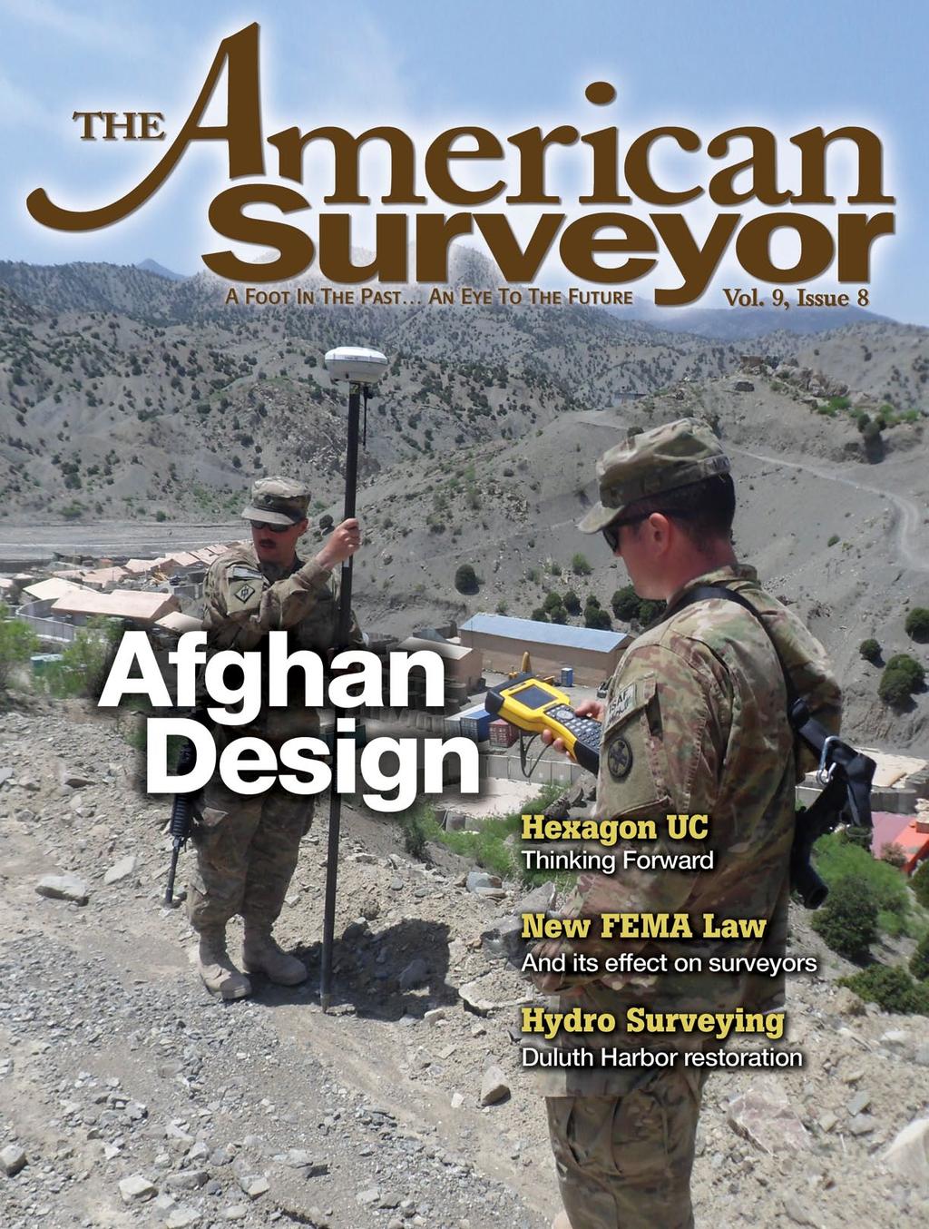
Displayed with permission The American Surveyor Vol. 9 No. 8 Copyright 2012 Cheves Media
|
|
|
- Gary Whitehead
- 6 years ago
- Views:
Transcription
1

2 Barr Engineering s John Novack pilots the vessel while Jim Staberg reviews readings from the Hypack software which merges data from the Odom sounder and Topcon HiPer Lite+ GPS.


3 A Superior Effort Engineering firm teams up GPS with hydrographic equipment to map out floor of bay to guide restoration ven though it s been a valuable and beneficial technology for decades now, GPS by nature of its accuracy and inherent versatility continues to find new uses and make inroads into new markets. Companies faced with difficult or seemingly impossible tasks are discovering that GPS can often provide the means to get the answers they need, even in the unlikeliest of situations. No one understands that better than Barr Engineering. The Minneapolis-area engineering and environmental consulting firm has repeatedly been challenged by clients seeking solutions which are beyond the reach of traditional technologies but nicely fit into the realm of GPS. One of the latest examples is a project to map sediments in the St. Louis River estuary as a prelude to habitat enhance- >> By Larry Trojak

4 Bed Elevation < 664 feet > 688 feet A sample 3D model of bed elevation data collected using the Odom/Topcon pairing. Teaming up the two technologies provides survey-grade location information accurate to 1/100 of a foot. ment. Combining the depth-finding capability of a hydrographic unit with the spatial strengths of GPS allowed them to map the floor, identify variability in the submerged surface, and, most importantly, meet the needs of their clients. What Lies Below A key component to the area from a geographic, social and economic standpoint, the lower St. Louis River provides critical habitat to bottom-feeding organisms, fish, and waterfowl species, while, at the same time, providing an economic venue for Great Lakes shipping and business in the Duluth-Superior Harbor. Over the past 130 years, economic development of this area, while certainly beneficial to the region, has contributed a mixture of contaminants to the waterway, including polycyclic aromatic hydrocarbons (PAHs), mercury and other metals, and various chlorinated organic compounds. Over time, some of these contaminants have accumulated in the sediments, raising concerns about their potential ecological and human health effects, and prompting an evaluation prior to restoring the habitat. One facet of the remedy evaluation process includes identifying variability within the sediment surface an important characteristic for understanding the role of wind, waves and river currents in sediment depositional patterns, according to Jim Staberg, Barr s Senior Civil Technician. The St. Louis River, which empties into Lake Superior in Duluth, is a unique environment for sediments, he says. It is a huge flooded estuary where sediments carried from the upper reaches of the river are deposited as the river loses its momentum. But once deposited, some sediment can be reworked by wind, waves and seiches, which act like tides and can cause flow in the estuary to reverse. In some areas, the estuary is more than three thousand feet wide, with a narrow main channel and the remainder of it being quite shallow. Accurate mapping of the shallow areas is essential for developing a precise model of the forces of nature on the sediment material that, despite the years that have passed, might still not be stable in some areas. So we were asked to go in, locate those shallow areas, and allow geologists and engineers to determine how to improve the habitat while maintaining the stability of the existing materials. Barr has completed many sedimentrelated projects that have called for the use of hydrographic equipment to measure water depths, but the extent of the open spaces in the St. Louis River estuary still proved demanding. Using an Odom hydrographic system, however, they ve been able to shoot soundings to gather depths to within 1/10 of a foot accuracy. In this case, though, we also had to locate the soundings with horizontal accuracies to 1/100, says Staberg. That meant the sub-meter capable GPS we d been using to that point would not suffice. Luckily for us, we had an alternative ready.
5 Bottom Elevation (feet) less than A similar reading of river bottom elevations. Barr s data is rendered using AutoCAD Civil 3D software. Complimentary Technologies Barr Engineering s alternative approach to tackling sediment mapping in the St. Louis River estuary was to team up their Odom hydrographic unit with HiPer Lite+ GPS from Topcon Positioning Systems. Doing so, says Staberg, gave them the accuracies they and their clients needed. Staberg says, we were able to use a 16-foot jon boat to survey the river bottom to 1/10 of a foot elevation and at the same time, gather survey-grade location information to 1/100 of a foot. It was an outstanding pairing of the two technologies. After each day s readings, we processed the data using the Hypack Hydrographic Survey and Processing Software which we generally use with our Odom gear, then brought that data into AutoCAD s Civil 3D for the final product: a 3D surface model of the river bottom. As mentioned, the key areas being focused upon were the shallower parts of the estuary and the bulk of the work was in water that ranged from three to six feet deep. On Measuring Mud GPS has been a big part of Barr Engineering s operation since about 1997 when their dealer rep, Fred Meyer from the Minneapolis branch of RDO Equipment, suggested they try out a receiver he had on hand. They used that model for about three years until RDO became the regional dealer for Topcon, at which point Barr made the switch. Today, between their Minneapolis and Duluth offices, they have a half-dozen systems to meet a growing, diverse, project base. It s amazing how the work almost seems to find the technology, says Staberg. Last year Topcon introduced the IS total station and Fred brought in a unit to demo it for us. At the time I really didn t see any immediate need for a tool like that, but not more than a month later, we got a call from an engineer asking if we could scan mud. It was one of the stranger requests we ve had but it got me thinking about that Imaging Station. The project in question did, indeed, involve mud, more specifically, mud that was a residual by-product (tailings) from Canadian mines, which has a difficult time drying out on its own. As a result, flocculants are being used to speed up that drying process. That s where Barr comes in; by monitoring the mud surface as the tailings dry during field demonstration projects to develop tailings management techniques.


6 The field demonstration project involved depositing tailings in individual test cells each a quarter mile long by 600 feet wide and the client needs to know how fast it is drying and if there is any shrinkage, says Staberg. They had no idea how to accurately do that, so they called us. We went in with a Topcon IS, but even we were unsure of how well it would work in that application. All About the Satisfaction That reluctance was due to the fact Staberg and his team didn t initially know how wet the mud was going to be and if they would be able to even get a return off it. A test run scanning a lake with lily pads proved that it worked quite well, so they moved forward. On the mud itself, wherever there was standing water, we didn t get a return, so we tried to keep our grid down to a meter in width and length. From the client s perspective, it was really a work in progress: they would fill one cell, then try different flocculants and chemical agents in an attempt to speed up the drying process. So we would take the Topcon unit out to the cell one day, scan it, then do it again the following day to see how quickly it was drying. Because of the large size of the cells, Staberg says they were limited to doing no more than one per day. He and his crew were onsite for three months, gathering data, post-processing it, again through AutoCAD Civil 3D, and using the resultant models to compare scans and evaluate shrinkage. In our mind, that was a really successful project and I have to believe the client feels the same way, he says. The Imaging Station played the key role out there and we ve since started using it for a lot of work in the area in which we are monitoring monuments on dams, then periodically checking to make certain the structure isn t moving. The technology whether it s GPS or a robotic total station has served us extremely well and helped us grow our business in ways we never expected. He adds that they feel very fortunate to have had the level of support they ve Using a Topcon FC-200 field controller, Staberg monitors data from the onboard HiPer Lite+ GPS unit. gotten from RDO. Fred and his team at the Integrated Controls division have helped us every step of the way as we ve grown into these newer technologies. It s really been a nice fit for us. Larry Trojak is a communications writer for his own firm, Trojak Communications, in the town of Ham Lake, Minnesota. He is a frequent contributor to construction and survey magazines.
Exploring the boundaries of your built and natural world. Geomatics
 Exploring the boundaries of your built and natural world Geomatics Before the Luxor brought magic to the Las Vegas strip and before the South LRT extension in Edmonton gave residents a new route to travel,
Unit 1, Lesson 2. What is geographic inquiry?
 What is geographic inquiry? Unit 1, Lesson 2 Understanding the way in which social scientists investigate problems will help you conduct your own investigations about problems or issues facing your community
Unit 1, Lesson 3 What Tools and Technologies Do Geographers Use?
 Unit 1, Lesson 3 What Tools and Technologies Do Geographers Use? Geographers use a variety of tools and technologies in investigating geographic questions. Maps and globes both represent the earth, but
Identified a possible new offset location where the customer is currently exploring drill options.
 GroundMetrics was hired to conduct a Full-Field Resistivity Survey for an oil and gas producer that needed to make crucial decisions to drive profitability at the location. The results saved them hundreds
Illinois River Sediment Quality and Beneficial Use Options
 Illinois River Sediment Quality and Beneficial Use Options John C. Marlin Illinois Sustainable Technology Center Robert G. Darmody Dept. of Natural Resources and Environmental Science University of Illinois
Table of Contents. Introduction 4. Chapter 1 Research and the Deep Oceans 6. Chapter 2 Physical Characteristics of the Ocean 10
 Table of Contents Introduction 4 Chapter 1 Research and the Deep Oceans 6 Chapter 2 Physical Characteristics of the Ocean 10 Chapter 3 Composition of the Oceans Waters 16 Chapter 4 Tides, Waves, and Currents
Mapping the Badlands. Surveying and GIS Just Got Easier. >> By Deral Paulk, LS
 $4.95 Mapping the Badlands Surveying and GIS Just Got Easier Surveying and mapping here in southwestern Oklahoma can be a challenge. It s a rough-hewn landscape with rugged terrain features and plenty
Alluvium Consulting Australia Senior integrated water management specialist Position Description March 2018
 Alluvium Consulting Australia Senior integrated water management specialist Position Description March 2018 Overview of Alluvium We are an employee-owned consulting firm founded in 2006 to provide advice
GIS Geographical Information Systems. GIS Management
 GIS Geographical Information Systems GIS Management Difficulties on establishing a GIS Funding GIS Determining Project Standards Data Gathering Map Development Recruiting GIS Professionals Educating Staff
Highland Lake Bathymetric Survey
 Highland Lake Bathymetric Survey Final Report, Prepared For: The Town of Highland Lake 612 Lakeshore Drive Oneonta, AL 35121 Prepared By: Tetra Tech 2110 Powers Ferry Road SE Suite 202 Atlanta, GA 30339
Shape of the Earth. Data Output by the Receiver
 It is quite common for confusion to arise about the process used during a hydrographic survey when GPS-derived water surface elevation is incorporated into the data as an RTK Tide correction. This article
SEDIMENT TRANSPORT IN RIVER MOUTH ESTUARY
 SEDIMENT TRANSPORT IN RIVER MOUTH ESTUARY Katsuhide YOKOYAMA, Dr.Eng. dredge Assistant Professor Department of Civil Engineering Tokyo Metropolitan University 1-1 Minami-Osawa Osawa, Hachioji,, Tokyo,
ADVENTURES IN WATER DEVELOPED BY LOUISVILLE WATER COMPANY
 ADVENTURES IN WATER DEVELOPED BY LOUISVILLE WATER COMPANY Tunneling for Water explains the science behind a first-of-its-kind project in the world! Louisville Water Company is the first water utility
Notes and Summary pages:
 Topographic Mapping 8.9C Interpret topographical maps and satellite views to identify land and erosional features and predict how these shapes may be reshaped by weathering ATL Skills: Communication taking
MA30S APPLIED UNIT F: DATA MANAGEMENT CLASS NOTES
 1 MA30S APPLIED UNIT F: DATA MANAGEMENT CLASS NOTES 1. We represent mathematical information in more ways than just using equations! Often a simple graph or chart or picture can represent a lot of information.
IMPLEMENTAION OF GIS TECHNOLOGY IN THE NILE AND ITS WADIS ABSTRACT
 IMPLEMENTAION OF GIS TECHNOLOGY IN THE NILE AND ITS WADIS Eng. NADIA M. ABD EI- SALAM 1 Dr. ABDEL AZIZ TAREK M. 2 ABSTRACT Traditional methods have been used for several years for map production of the
Document A: Herodotus (Modified)
") Document A: Herodotus (Modified) The following is an excerpt from The Histories written by the Greek historian Herodotus in 440 BCE. Herodotus spent much of his life traveling to collect information for
Document A: Herodotus (Modified) The following is an excerpt from The Histories written by the Greek historian Herodotus in 440 BCE. Herodotus spent much of his life traveling to collect information for
GEO 105 Oil and Gas Exploration Project
 GEO 105 Oil and Gas Exploration Project Modified from: Friedman, G.M., Johnson, K.G., 1982, Exercises in Sedimentology, John Wiley, p. 208 (via Reames and Carrigan at Olivet University) Student Learning
Tenmile Lakes Delta Building Study
 Tenmile Lakes Delta Building Study Since the late 1940 s, Tenmile Lakes has seen a sharp increase in sediment accumulation at the mouths of the tributaries that feed the lake. To monitor this sediment
It s true, these activities are all facets of marine science. But they represent a pretty small part of the picture.
 Welcome. Thanks for coming to CBNERR s Discovery Lab. I m Lisa Lawrence and I m a marine educator at VIMS. Tonight, I m going to give you just glimpse of what it s like to be a marine scientist and tell
Island Design. UMRS EMP Regional Workshop. Presentation for the
 Island Design Presentation for the UMRS EMP Regional Workshop by Jon Hendrickson Hydraulic Engineer Regional Technical Specialist, Water Quality and Habitat Restoration August 17 19, 2005 Project Delivery
Flood Hazard Zone Modeling for Regulation Development
 Flood Hazard Zone Modeling for Regulation Development By Greg Lang and Jared Erickson Pierce County GIS June 2003 Abstract The desire to blend current digital information with government permitting procedures,
Teacher s Guide for Dig
 Teacher s Guide for Dig February 2015: Yellow River Teacher's Guide prepared by E. Renee Heiss, writer and educator. A Downstream Journey Page 2 Chart The Yellow River is the second-longest river in China
Algebra Exam. Solutions and Grading Guide
 Algebra Exam Solutions and Grading Guide You should use this grading guide to carefully grade your own exam, trying to be as objective as possible about what score the TAs would give your responses. Full
Texas A & M University and U.S. Bureau of Reclamation Hydrologic Modeling Inventory Model Description Form
 Texas A & M University and U.S. Bureau of Reclamation Hydrologic Modeling Inventory Model Description Form JUNE, 1999 Name of Model: Two-Dimensional Alluvial River and Floodplain Model (MIKE21 CHD & CST)
Saskatchewan s Mineral Resources Lesson: Exploring for Minerals in Saskatchewan: Stream Sediment and Soil Sampling
 Saskatchewan s Mineral Resources Lesson: Exploring for Minerals in Saskatchewan: Stream Sediment and Soil Sampling Overview In this activity, students use information from geochemical surveys (stream sediment
Your web browser (Safari 7) is out of date. For more security, comfort and the best experience on this site: Update your browser Ignore
 is out of date. For more security, comfort and the best experience on this site: Update your browser Ignore") Your web browser (Safari 7) is out of date. For more security, comfort and the best experience on this site: Update your browser Ignore ALLU VIAL FAN colluvial fan, debris cone For the complete encyclopedic
Your web browser (Safari 7) is out of date. For more security, comfort and the best experience on this site: Update your browser Ignore ALLU VIAL FAN colluvial fan, debris cone For the complete encyclopedic
Seagrass Transplantation & Environmental & Marine Consulting Services, Inc. Drew Campbell, Vice President & Lead Scientst.
 Indian River Lagoon Symposium Seagrass Transplantation & Project Considerations Environmental & Marine Consulting Services, Inc. Drew Campbell, Vice President & Lead Scientst March 26 th, 2013 Regulatory
Learning Objectives: I can identify and interpret river flows and directions.
 Learning Objectives: I can identify and interpret river flows and directions. Bellringer Review: Check for Understanding Questions: 1 2 What Are The Key Parts Of A River s Anatomy? In your data notebooks
Urban Foundations. Early American Cities. Early American Cities. Early American Cities. Cities in America to 1945
 Urban Foundations Cities in America to 1945 Early American Cities The design of early American cities was highly influenced by European traditions The roots of many of these traditions can in turn be traced
Glacial Deposition and Groundwater in Dutchess County
 Glacial Deposition and Groundwater in Dutchess County Name: Period: Thousands of years ago an enormous ice sheet blanketed the Hudson Valley in what was called the Wisconsinan Glaciation. The ice reshaped
APPENDIX E. GEOMORPHOLOGICAL MONTORING REPORT Prepared by Steve Vrooman, Keystone Restoration Ecology September 2013
 APPENDIX E GEOMORPHOLOGICAL MONTORING REPORT Prepared by Steve Vrooman, Keystone Restoration Ecology September 2 Introduction Keystone Restoration Ecology (KRE) conducted geomorphological monitoring in
Your web browser (Safari 7) is out of date. For more security, comfort and the best experience on this site: Update your browser Ignore
 is out of date. For more security, comfort and the best experience on this site: Update your browser Ignore") Your web browser (Safari 7) is out of date. For more security, comfort and the best experience on this site: Update your browser Ignore CO NTINENTAL SHEL F For the complete encyclopedic entry with media
Your web browser (Safari 7) is out of date. For more security, comfort and the best experience on this site: Update your browser Ignore CO NTINENTAL SHEL F For the complete encyclopedic entry with media
Gradualism versus Catastrophism Curriculum written by XXXXX
 Gradualism versus Catastrophism Curriculum written by XXXXX A curriculum written with the goal of educating 8 th grade science students on the difference between gradual and cataclysmic geological events
Coso Red Hill and Coso Playa field trip, Prof. Alessandro Grippo, Ph.D.
 HISTORICAL GEOLOGY fall 2016 Professor: Dr. Alessandro Grippo, Ph.D. FIELD TRIP REPORT: Friday, October 21, 2016: Coso Red Hill & Playa, Coso Junction CA YOUR NAME part 1: COSO RED HILL (you can sample
Advanced Hydraulics Prof. Dr. Suresh A Kartha Department of Civil Engineering Indian Institute of Technology, Guwahati
 Advanced Hydraulics Prof. Dr. Suresh A Kartha Department of Civil Engineering Indian Institute of Technology, Guwahati Module - 2 Uniform Flows Lecture - 6 Design of Channels for Uniform Flow (Refer Slide
Advanced Hydraulics Prof. Dr. Suresh. A. Kartha Department of Civil Engineering Indian Institute of Technology, Guwahati
 Advanced Hydraulics Prof. Dr. Suresh. A. Kartha Department of Civil Engineering Indian Institute of Technology, Guwahati Module - 2 Uniform Flows Lecture - 4 Uniform Flow in Compound Sections Concept of
Erosional Features. What processes shaped this landscape?
 Have you ever looked at the land around you and wondered what processes shaped what you see? Perhaps you see mountains, valleys, rivers, or canyons. Do you know how long these geologic features have been
One Hilltop, Three Major Watersheds!
 One Hilltop, Three Major Watersheds! Adapted from: An original Creek Connections activity. Creek Connections, Box E, Allegheny College, Meadville, Pennsylvania, 16335 Watersheds of PA/ Topo Map Review
The future of the geomatics profession and where we fit in
 The future of the geomatics profession and where we fit in by Altus Strydom, Geo-Spatial Consulting Abstract For years now the geomatics profession has been bombarded with a changing environment, volatile
Stream Restoration and Environmental River Mechanics. Objectives. Pierre Y. Julien. 1. Peligre Dam in Haiti (deforestation)
") Stream Restoration and Environmental River Mechanics Pierre Y. Julien Malaysia 2004 Objectives Brief overview of environmental river mechanics and stream restoration: 1. Typical problems in environmental
Stream Restoration and Environmental River Mechanics Pierre Y. Julien Malaysia 2004 Objectives Brief overview of environmental river mechanics and stream restoration: 1. Typical problems in environmental
RATES OF CHANGE. A violin string vibrates. The rate of vibration can be measured in cycles per second (c/s),;
,;") DISTANCE, TIME, SPEED AND SUCH RATES OF CHANGE Speed is a rate of change. It is a rate of change of distance with time and can be measured in miles per hour (mph), kilometres per hour (km/h), meters per
DISTANCE, TIME, SPEED AND SUCH RATES OF CHANGE Speed is a rate of change. It is a rate of change of distance with time and can be measured in miles per hour (mph), kilometres per hour (km/h), meters per
River Restoration and Rehabilitation. Pierre Y. Julien
 River Restoration and Rehabilitation Pierre Y. Julien Department of Civil and Environmental Engineering Colorado State University Fort Collins, Colorado River Mechanics and Sediment Transport Lima Peru
GY 111 Lecture Note Series Sedimentary Environments 2: Rivers and Deltas
 GY 111 Lecture Notes D. Haywick (2008-09) 1 GY 111 Lecture Note Series Sedimentary Environments 2: Rivers and Deltas Lecture Goals A) Rivers and Deltas (types) B) Water Flow and sedimentation in river/deltas
STUDY GUIDE. Exploring Geography. Chapter 1, Section 1. Terms to Know DRAWING FROM EXPERIENCE ORGANIZING YOUR THOUGHTS
 For use with textbook pages 19 22. Exploring Geography Terms to Know location A specific place on the earth (page 20) absolute location The exact spot at which a place is found on the globe (page 20) hemisphere
Pirai river (Bolivia)
") Pirai river (Bolivia) Confluent of the Amazon river which average discharge is only 6 m3/s, but with peak discharge over 5000 m3/s, a challenge for river basin management and for flood control HYDROEUROPE
Pirai river (Bolivia) Confluent of the Amazon river which average discharge is only 6 m3/s, but with peak discharge over 5000 m3/s, a challenge for river basin management and for flood control HYDROEUROPE
Steven Noble MDEQ - WRD Enbridge Response Unit
 EPA situation report, October 19, 2012 Steven Noble MDEQ - WRD Enbridge Response Unit Brief history of the spill Monitoring Monitoring the impacts Follow the oil The Current Situation A Look at the Future
Show Me the Money. >> By Robert L. Young, LS
 Show Me the Money here is a lot of talk about the role that GIS plays in business, and in society at large. I d like to talk about what GIS means to surveyors, at least to this surveyor: my experience
Lake Sedimentation Survey of Siloam Springs State Park Lake, Adams County, Illinois
 Contract Report 567 Lake Sedimentation Survey of Siloam Springs State Park Lake, Adams County, Illinois by Richard L. Allgire Office of Sediment & Wetland Studies Prepared for the Illinois Department of
Developing a Community Geographical Information System (GIS) in Rural India
 in Rural India") Developing a Community Geographical Information System (GIS) in Rural India Before rushing off and describing the unique challenges of developing a small scale GIS system India I better first describe
Developing a Community Geographical Information System (GIS) in Rural India Before rushing off and describing the unique challenges of developing a small scale GIS system India I better first describe
GEOL- 270: Issues in Oceanography Developed by Jessica Kleiss, Lewis & Clark College
 GEOL- 270: Issues in Oceanography Developed by Jessica Kleiss, Lewis & Clark College Lab 02: Ocean floor bathymetry. Material for students to bring: A calculator A ruler Pens and pencils Objectives: Interpret
Essential Question: How are the geological features that exist on land similar to the geological features on the ocean floor?
 Essential Question: How are the geological features that exist on land similar to the geological features on the ocean floor? Geography of the Oceans The world ocean can be divided into four main ocean
U.S. ARMY CORPS OF ENGINEERS
 CORPS FACTS Regulating Mississippi River Navigation Pools U.S. ARMY CORPS OF ENGINEERS BUILDING STRONG Historical Background Federal improvements in the interest of navigation on the Mississippi River
National Marine Sanctuary Program
 National Marine Sanctuary Program NMSP/USGS Joint Seabed Mapping Initiative: September 2004 AA National Ocean Service National Marine Sanctuaries Interim Report September 2004 Background: Since 2002,
Spatial Survey of Surface Soil Moisture in a Sub-alpine Watershed Colloquium Presentation, University of Denver, Department of Geography
 Thank you all for coming today. I will be talking about my thesis work concerning the spatial distribution of soil moisture in an alpine catchment. But first we need some background in soil moisture. Why
FLOOD PLAIN SIMULATION MODEL BY INTEGRATION OF SURVEYING PACKAGES AND GIS
 FLOOD PLAIN SIMULATION MODEL BY INTEGRATION OF SURVEYING PACKAGES AND GIS Azrinda Hassan Mohamad and Md.Nor Kamarudin Department of Geomatics Engineering, Faculty of Geoinformation Science and Engineering
EROSIONAL FEATURES. reflect
 reflect Have you ever looked at the land around you and wondered what processes shaped what you see? Perhaps you see mountains, valleys, rivers, or canyons. Do you know how long these geologic features
How GIS can be used for improvement of literacy and CE programmes
 How GIS can be used for improvement of literacy and CE programmes Training Workshop for Myanmar Literacy Resource Center (MLRC) ( Yangon, Myanmar, 11 20 October 2000 ) Presented by U THEIN HTUT GEOCOMP
Physics 8 Wednesday, September 30, 2015
 Physics 8 Wednesday, September 30, 2015 You ve recently read Chapter 8 ( force ), Chapter 9 ( work ), and Chapter 10 ( motion in a plane ). In the coming weeks, class/hw will fall a bit behind the reading.
3. If a forecast is too high when compared to an actual outcome, will that forecast error be positive or negative?
 1. Does a moving average forecast become more or less responsive to changes in a data series when more data points are included in the average? 2. Does an exponential smoothing forecast become more or
TECHNICAL SUPPORT FOR NY/NJ HARBOR ESTUARY PROGRAM USEPA REGION 2 TOXICS TMDL MODEL DEVELOPMENT. New York/New Jersey Harbor Estuary Program
 New York/New Jersey Harbor Estuary Program SEDIMENT AREA LOADING COMPONENT ANALYSIS AND SPREADSHEET TOOL DEVELOPMENT II HACKENSACK RIVER AND LOWER/RARITAN BAYS INTERPRETATIVE TECHNICAL MEMORANDUM TECHNICAL
Channel responses to the removal of Gold Ray and Savage Rapids Dam. Prepared by Desirée Tullos and Cara Water
 Channel responses to the removal of Gold Ray and Savage Rapids Dam Prepared by Desirée Tullos and Cara Water Introduction. As the results of extensive efforts over several decades, the Rogue River is now
Classwork 2.4 Trigonometric Ratios- Application Problems. 1. How tall is the building? 2. How far up will the ladder reach?
 1. How tall is the building? 2. How far up will the ladder reach? 3. A rock dropped from the top of the Leaning Tower of Pisa falls to a point 14 feet from the base. If the tower is 182 feet tall, at what
Great Lakes Update. Great Lakes Winter and Spring Summary January June Vol. 187 Great Lakes Update August 2012
 Great Lakes Update Great Lakes Winter and Spring Summary January June 2012 The US Army Corps of Engineers (USACE) Detroit District monitors hydraulic and hydrologic conditions of the Great Lakes. This
Heuristic Tidal Advisor: An Innovative Algorithm for Tidal Prediction. Dr S E Taylor. MD. Geomatix Ltd UK. Sep 2016
 Heuristic Tidal Advisor: An Innovative Algorithm for Tidal Prediction. Dr S E Taylor. MD. Geomatix Ltd UK. Sep 2016 Abstract The height of the tide is caused not only by the tide raising forces of the
Estimated Sediment Volume: Bridge Street Dam Impoundment, Royal River, Yarmouth, Maine
 University of Southern Maine USM Digital Commons Publications Casco Bay Estuary Partnership (CBEP) 2015 Estimated Sediment Volume: Bridge Street Dam Impoundment, Royal River, Yarmouth, Maine Stantec Follow
The Shunammite Woman s Land Restored 2 Kings 8:1-6
 Lesson 111 The Shunammite Woman s Land Restored 2 Kings 8:1-6 MEMORY VERSE 2 KIN GS 8:6 Restore all that w as hers, and all the proc eeds of the field from the day that she left the land until now. WHAT
Prediction of changes in tidal system and deltas at Nakdong estuary due to construction of Busan new port
 Prediction of changes in tidal system and deltas at Nakdong estuary due to construction of Busan new port H. Gm1 & G.-Y. park2 l Department of Civil & Environmental Engineering, Kookmin University, Korea
Hydraulics Prof. Dr. Arup Kumar Sarma Department of Civil Engineering Indian Institute of Technology, Guwahati
 Hydraulics Prof. Dr. Arup Kumar Sarma Department of Civil Engineering Indian Institute of Technology, Guwahati Module No. # 04 Gradually Varied Flow Lecture No. # 07 Rapidly Varied Flow: Hydraulic Jump
Mining for Gold: Kenora s
 Photo Credit: Tom Thomson Photography www.tomthomson.com Mining for Gold: Kenora s Comeback Dryden, Ontario has a great future based on the gold being developed by Treasury Metals at its flagship Goliath
GY 111 Lecture Notes Intro to Metamorphism
 GY 111 Lecture Notes D. Haywick (2008-09) 1 Lecture Goals: A) Agents of Metamorphism B) Types of metamorphism C) Hydrothermal fluids GY 111 Lecture Notes Intro to Metamorphism Reference: Press et al.,
POST CABLE INSTALLATION THERMAL MONITORING PROGRAM LONG ISLAND REPLACEMENT CABLE PROJECT NORWALK, CT OSI JOB# 08ES069
 28 July 2009 Mark D. Driscoll, M.S. Senior Water Resources Scientist. 888 Worcester Street, Suite 2 Wellesley, MA 02482 SUBJECT: FINAL REPORT POST CABLE INSTALLATION THERMAL MONITORING PROGRAM LONG ISLAND
MITOCW big_picture_derivatives_512kb-mp4
 MITOCW big_picture_derivatives_512kb-mp4 PROFESSOR: OK, hi. This is the second in my videos about the main ideas, the big picture of calculus. And this is an important one, because I want to introduce
4 billion light years in the making: one UW-River Falls professor s journey to a scientific breakthrough Kelsea Wissing/UWRF Communications
 University Communications 120 North Hall 410 S. 3rd St., River Falls, WI 54022 715-425-3771 4 billion light years in the making: one UW-River Falls professor s journey to a scientific breakthrough Kelsea
Natural hazards in Glenorchy Summary Report May 2010
 Natural hazards in Glenorchy Summary Report May 2010 Contents Glenorchy s hazardscape Environment setting Flood hazard Earthquakes and seismic hazards Hazards Mass movement Summary Glossary Introduction
MUDMAP TM. Software Description
 ASA Applied Science Associates, Inc. 70 Dean Knauss Drive Narragansett, RI 02882-1143 U.S.A. Tel: 401-789-6224 Fax: 401-789-1932 asa@asascience.com www.asascience.com MUDMAP TM Software Description MUDMAP
Redwood City Harbor, California, Navigation Improvement Feasibility Study. Appendix D. Geotechnical Engineering. DRAFT April 2015
 1 Redwood City Harbor, California, Navigation Improvement Feasibility Study Appendix D Geotechnical Engineering DRAFT April 2015 2 Contents 1 Purposes of Report... 3 2 Background... 3 3 References and
Number System Chapter Questions
 Number System Chapter Questions. What is an integer?. Explain what absolute value represents.. Create an owing money example for comparing two negative numbers.. What is the Cartesian (Coordinate) plane?
CoCoRaHS. Community Collaborative Rain, Hail, & Snow Network. Ashley Wolf Meteorologist NWS Green Bay Northeast Wisconsin CoCoRaHS Coordinator
 CoCoRaHS Community Collaborative Rain, Hail, & Snow Network Ashley Wolf Meteorologist NWS Green Bay Northeast Wisconsin CoCoRaHS Coordinator What is CoCoRaHS Who, What, Where and Whys of CoCoRaHS What?
CAUSES FOR CHANGE IN STREAM-CHANNEL MORPHOLOGY
 CAUSES FOR CHANGE IN STREAM-CHANNEL MORPHOLOGY Chad A. Whaley, Department of Earth Sciences, University of South Alabama, MobileAL, 36688. E-MAIL: caw408@jaguar1.usouthal.edu The ultimate goal of this
Inter State Large Navigable Rivers of the United States
 Inter State Large Navigable Rivers of the United States REVIEW OF NORTH AMERICAN BASINS: GREAT LAKES AND MISSISSIPPI RIVER HELEN A. BROHL, EXECUTIVE DIRECTOR US COMMITTEE ON THE MARINE TRANSPORTATION SYSTEM
Lab 2 The reinvasion of flowering plants into aquatic habitats
 Lab 2 The reinvasion of flowering plants into aquatic habitats BIOL 3601: PLANT DIVERSITY Lab Goals: To learn about adaptations of aquatic plants in different aquatic zones To learn common aquatic plants
CHEMICAL PROPERTIES OF THE SEA WATER IN THE NEIGHBOURHOOD OF THE LABADIE BANK By L. H. N. Cooper, D.Se., F.R.I.C. Chemist at the Plymouth Laboratory
 21 CHEMICAL PROPERTIES OF THE SEA WATER IN THE NEIGHBOURHOOD OF THE LABADIE BANK By L. H. N. Cooper, D.Se., F.R.I.C. Chemist at the Plymouth Laboratory (Text-figs. 1-3) A number of excursions to the Celtic
Surveying Prof. Bharat Lohani Department of Civil Engineering Indian Institute of Technology, Kanpur. Module - 3 Lecture - 4 Linear Measurements
 Surveying Prof. Bharat Lohani Department of Civil Engineering Indian Institute of Technology, Kanpur Module - 3 Lecture - 4 Linear Measurements Welcome again to this another video lecture on basic surveying.
A System View of Water Level Processes in the Lower Columbia River
 A System View of Water Level Processes in the Lower Columbia River David Jay Department of Civil & Environmental Engineering Portland State University, Portland, OR Amy Borde and Heida Diefenderfer Pacific
Highs and Lows Floods and Flows
 Highs and Lows Floods and Flows Planetary Mapping Facilitator Guide Becky Nelson Education Specialist The Lunar and Planetary Institute Highs and Lows, Floods and Flows Planetary Mapping Overview In this
The Montague Doppler Radar, An Overview
 ISSUE PAPER SERIES The Montague Doppler Radar, An Overview June 2018 NEW YORK STATE TUG HILL COMMISSION DULLES STATE OFFICE BUILDING 317 WASHINGTON STREET WATERTOWN, NY 13601 (315) 785-2380 WWW.TUGHILL.ORG
Sediment yield estimation from a hydrographic survey: A case study for the Kremasta reservoir, Western Greece
 Sediment yield estimation from a hydrographic survey: A case study for the Kremasta reservoir, Western Greece 5 th International Conference Water Resources Management in the Era of Transition,, Athens,
An Overview of the Tapia Canyon Field Static Geocellular Model and Simulation Study
 An Overview of the Tapia Canyon Field Static Geocellular Model and Simulation Study Prepared for Sefton Resources Inc. Jennifer Dunn, Chief Geologist Petrel Robertson Consulting Ltd. Outline Background
Linear Functions, Equations, and Inequalities
 CHAPTER Linear Functions, Equations, and Inequalities Inventory is the list of items that businesses stock in stores and warehouses to supply customers. Businesses in the United States keep about.5 trillion
Newton s Wagon. Materials. friends rocks wagon balloon fishing line tape stopwatch measuring tape. Lab Time Part 1
 Newton s Wagon Overview: The natural state of objects is to follow a straight line. In fact, Newton s First Law of Motion states that objects in motion will tend to stay in motion unless they are acted
Earth Science Lesson Plan Quarter 2, Week 10, Day 1
 Earth Science Lesson Plan Quarter 2, Week 10, Day 1 Outcomes for Today Standard Focus: PREPARE 1. Background knowledge necessary for today s reading. Beaches are created by the actions of waves, tides,
DRIVE vs. BALANCE August 10, By Michael Erlewine
 DRIVE vs. BALANCE August 10, 2012 By Michael Erlewine (Michael@Erlewine.net) We Become What We Want Why do we have the drive and ambition to accomplish some days and don t feel like doing much of anything
Jefferson Parish GIS Hurricane Response Review. From the information given by A.J. Tapie, GIS Manager of Jefferson Parish, the use of
 Neil Dixon and Ryan Ziegelbauer URPL 969 3/10/2006 Jefferson Parish GIS Hurricane Response Review From the information given by A.J. Tapie, GIS Manager of Jefferson Parish, the use of GIS in the Parish
Hurricane Katrina and Oil Spills: Impact on Coastal and Ocean Environments
 Archived version from NCDOCKS Institutional Repository http://libres.uncg.edu/ir/asu/ Pine, J. C. (June 2006). Hurricane Katrina and oil spills: Impact on coastal and ocean environments. Oceanography,
Sediments in a changing Environment Ecological implications of dredging and relocation in the Elbe estuary Günther Eichweber, WSD-Nord
 Sediments in a changing Environment Ecological implications of dredging and relocation in the Elbe estuary Günther Eichweber, WSD-Nord 2011-04-07 S1 Basic problem: sediment budget out of equilibrium 2011-04-07
Great South Channel Habitat Management Area Analysis. Committee tasking
 Great South Channel Habitat Management Area Analysis NEFMC Habitat Committee Meeting March 19, 2013 Salem, MA Committee tasking MOTION 5, (McKenzie, Alexander) from 12 4 12 meeting Move that the Committee
Cause (or Because) Effect Possible Questions and/or Conclusions
 Effect Possible Questions and/or Conclusions") TEACHER KEY: CHART FOR CAUSE AND EFFECT READING Changes in the Salinas Economy: Understanding a cause and effect reading Question: How did the railroad change the economy of the Salinas community? Cause
TEACHER KEY: CHART FOR CAUSE AND EFFECT READING Changes in the Salinas Economy: Understanding a cause and effect reading Question: How did the railroad change the economy of the Salinas community? Cause
1.1 What is Site Fingerprinting?
 Site Fingerprinting Utilizing GIS/GPS Technology 1.1 What is Site Fingerprinting? Site fingerprinting is a planning tool used to design communities where protection of natural resources is the primary
Witless Bay Ecological Reserve
 Newfoundland Adventure by Fabiola Forns The land of fog and icebergs is jut a few hours north of us by plane. We visited last year and decided to make it a regular destination. Wherever you look, there