Ground Water Control of Tree Island Origin, Genesis and Destruction. By John F. Meeder and Peter W. Harlem SERC,FIU
|
|
|
- Douglas Simmons
- 6 years ago
- Views:
Transcription


1 Ground Water Control of Tree Island Origin, Genesis and Destruction By John F. Meeder and Peter W. Harlem SERC,FIU
2 Functional Definition Our functional definition of a Tree Island is; an isolated scrub or tree community surrounded by either grasslands (marsh) or different upland or swamp forest types related to relative changes in elevation, substrate, and contact with the ground water
3 Unified theory for tree island development Based upon similarities between most types of tree islands which includes different: 1. vegetation 2. hydroperiod 3. soil types 4. topography 5. fire regime 6. relationship to ground water, from adjacent areas. Ground water availability influences all of the above
4 Primary Observations Most tree islands develop in areas associated with more contact with groundwater. The hydraulic head which drives ground water availability is controlled by the regional ground water table patterns.
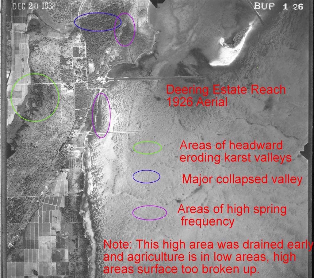
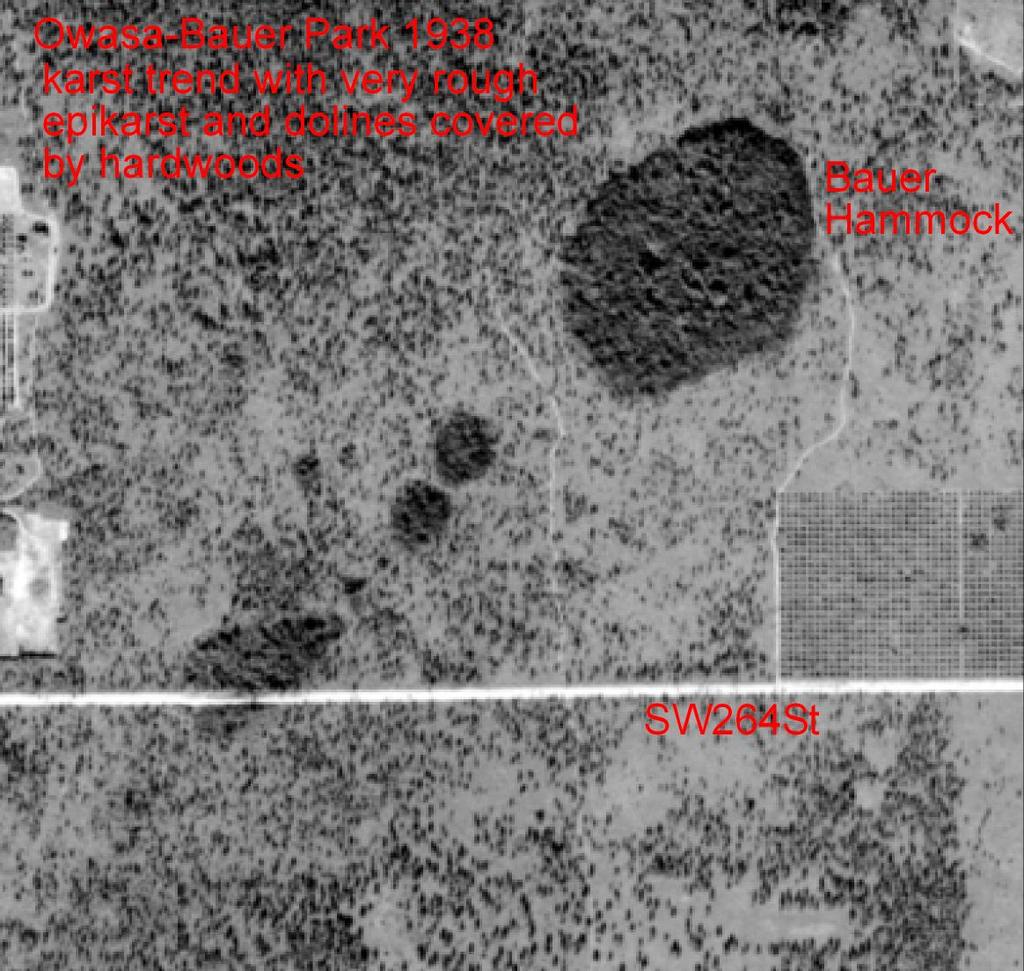
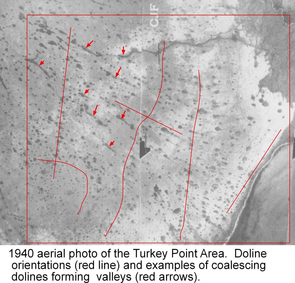
5 Types of tree islands by location 1. Uplands or transitional wetlands (short hydroperiod) controlled by: A. Epi-karst trends B.. Doline trends C.. Karst valleys and escarpments D. Other depositional topographies (relict sand bars and abandoned creek channels)) 2. Marsh Interiors (long hydroperiod) produced by: A. Flooding (battery islands) 1) Planted on ground water or karst surface (marginal) 2) Planted on non-ground water surface (marginal or interior) B. Depositional (areas of higher energy) 1) 100% fluvial doubtful 2) Deposition around an obstruction likely (tree growing in pot hole) 3) Flooded pre-existing existing topography (sand bars, buried karst)

6 Four models for increased ground water connection. Key is break in the marl seal.
 sea level rise")
")
 catastrophic battery island")
 Not all battery")
7 Rising water table by either: 1) impoundment or 2) sea level rise can increase: a) floatant or quaking marsh area, b) destabilization of root mat and c) catastrophic battery island formation, (not from normal scoring flows) Not all battery root mats form islands.
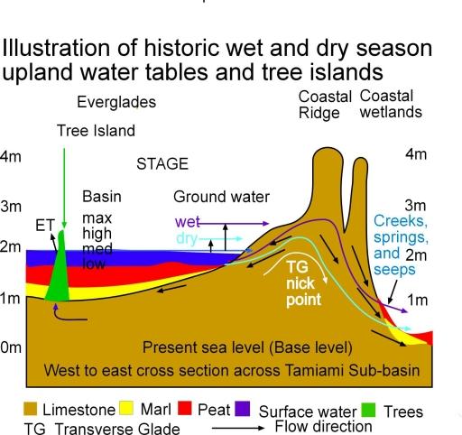
8 Importance of hydrologic head (Higher water table than in adjacent uplands) Historically, head was +2 to 4 ft higher than present in adjacent uplands. Higher water table in uplands provides a positive head in areas of seal disturbance (under tree islands) during dry seasons. Slight head with capillary action keeps tree islands moister. Tree islands less likely to burn
9
10
11
12
")
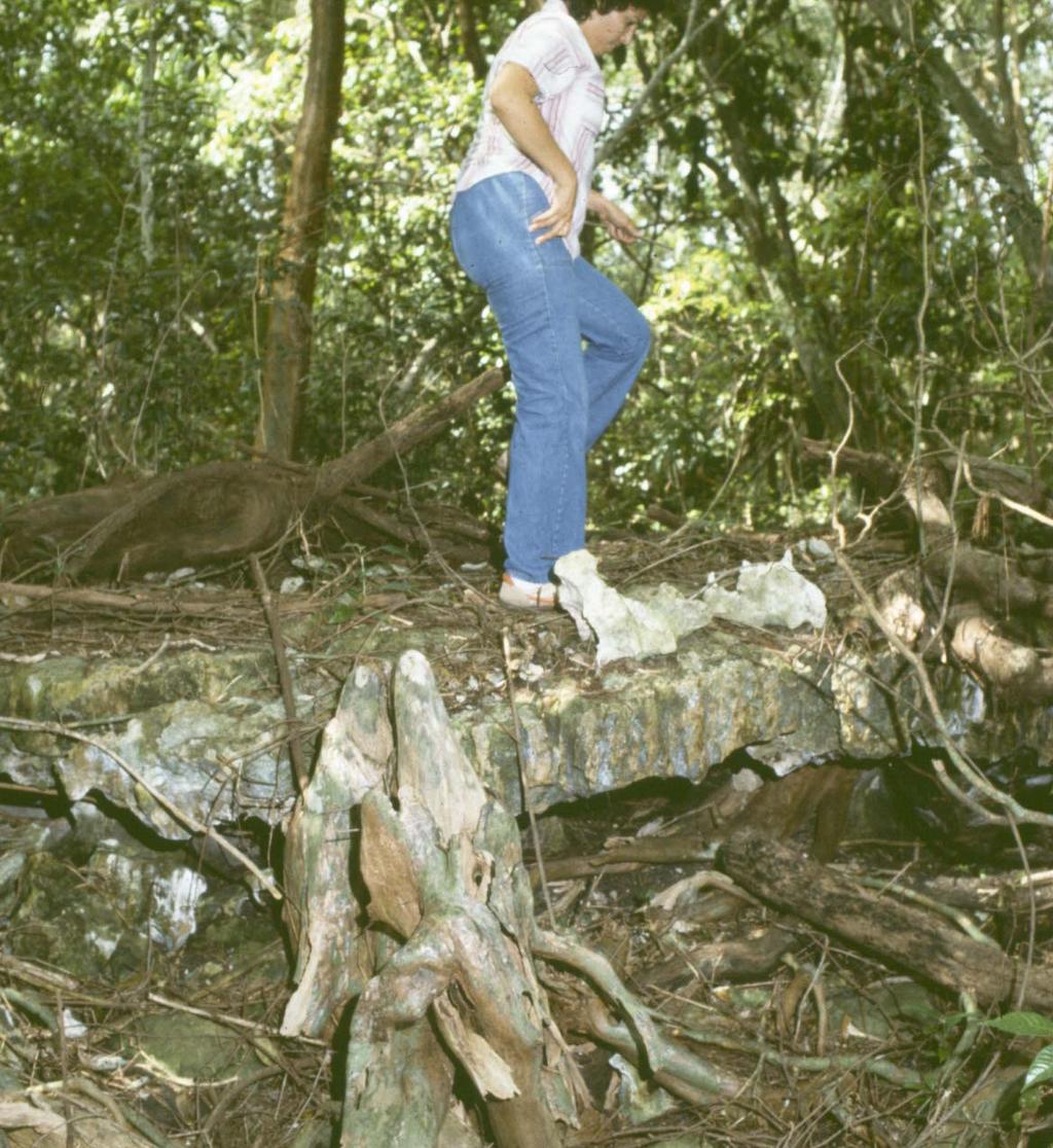
13 Karst escarpment along Snapper Creek Transverse Glade at (Sardowski Park)
14

15 Turkey Point Sediment Profile
16
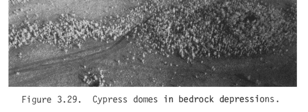
17 Karst origin of Cypress domes and sloughs
18
 Drowned")
19 1938 West Palm Beach (from wetland lower-left to uplands upper-right) NOTE: the change in doline patterns with submergence and the expanding karst valleys (enscribed by the yellow and blue lines) Drowned topography
20 CONCLUSIONS Many types of tree islands are associated with breaks in marl seal (frequently by karst) High water table in adjacent uplands during the dry season creates positive hydraulic head Break in seal and head produce wetter surface conditions Tree island trends often associated with shallow groundwater movement
21 Significance for Tree Island Restoration Restoration will only work well at large spatial scale, Restoration should focus on hydraulic head Final methodology needs to be determined after post restoration water table goals are set and reached. Restoration methods will be different for future conditions of either rising or dropping water table (sea level), and Lowering the adjacent marsh elevation to return the historic head might be injurious to other ecosystem components, Elevating flooded tree islands with organic sediments (temporary relief), If incorrect management choice is made the rate of continued loss will be accelerated.
22 Acknowledgements SERC-FIU for support

23 North of Corkscrew Swamp
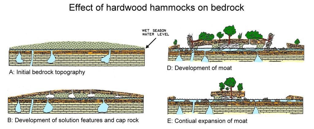
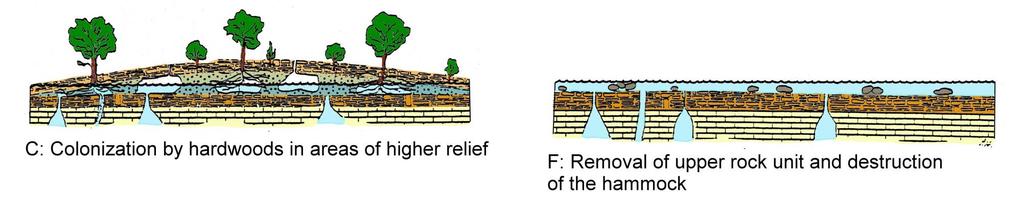
24 Effects of upward discharge of groundwater Reduce oxidation of organics Reduce fire frequency Positive topographic relief Mounding of ground and surface water Reduced salinity Increased soil moisture Increased humidity Dispersal of nutrients Most of these breaks in continuity are the results of karst processes,, either doline formation, solution pipes and surface dissolution features or erosional remnants.
25
Landscapes & Hydric Soils Bruce Vasilas University of Delaware
 Landscapes & Hydric Soils Bruce Vasilas University of Delaware Hydric soils are defined as soils that formed under conditions of saturation, flooding, or ponding long enough during the growing season to
ADDRESSING GEOMORPHIC AND HYDRAULIC CONTROLS IN OFF-CHANNEL HABITAT DESIGN
 ADDRESSING GEOMORPHIC AND HYDRAULIC CONTROLS IN OFF-CHANNEL HABITAT DESIGN Conor Shea - Hydrologist U.S. Fish and Wildlife Service Conservation Partnerships Program Arcata, CA Learning Objectives Examine
Ecological Patterns and Processes in Ghost Tree Islands of the Everglades
 Ecological Patterns and Processes in Ghost Tree Islands of the Everglades Sharon M. L. Ewe 1, Binhe Gu 2, Jennifer Vega 1 and Kristin Vaughan 1 1 Ecology and Environment Inc., 12300 South Shore Blvd, Wellington,
Marl Prairie vegetation response to 20th century land use and its implications for management in the Everglades
 Marl Prairie vegetation response to 20th century land use and its implications for management in the Everglades C. Bernhardt, D. Willard, B. Landacre US Geological Survey Reston, VA USA U.S. Department
Sediment and nutrient transport and storage along the urban stream corridor
 Sediment and nutrient transport and storage along the urban stream corridor Greg Noe, Cliff Hupp, Ed Schenk, Jackie Batson, Nancy Rybicki, Allen Gellis What is the role of floodplains everywhere? Noe 2013,
Changes in Texas Ecoregions Copy the questions and answers
 Changes in Texas Ecoregions Copy the questions and answers 1. What are some kinds of damage that hurricanes cause? Roads and bridges might be washed away. Trees and power lines can be knocked down. Area
Changes in Texas Ecoregions
 Comment On Lesson Changes in Texas Ecoregions The state of Texas can be divided into 10 distinct areas based on unique combinations of vegetation, topography, landforms, wildlife, soil, rock, climate,
Lab 12 Coastal Geology
 Lab 12 Coastal Geology I. Fluvial Systems Hydrologic Cycle Runoff that flows into rivers = precipitation (rain and snowmelt) [infiltration (loss to groundwater) + evaporation (loss to atmosphere) + transpiration
Appendix E: Cowardin Classification Coding System
 Appendix E: Cowardin Classification Coding System The following summarizes the Cowardin classification coding system and the letters and numbers used to define the USFWS NWI wetland types and subtypes:
3/3/2013. The hydro cycle water returns from the sea. All "toilet to tap." Introduction to Environmental Geology, 5e
 Introduction to Environmental Geology, 5e Running Water: summary in haiku form Edward A. Keller Chapter 9 Rivers and Flooding Lecture Presentation prepared by X. Mara Chen, Salisbury University The hydro
Landscape-scale trends and. Islands in the Everglades. Sharon M. L. Ewe, Binhe Gu, Jennifer Vega, Kristin Vaughan, Sumanjit Aich
 Landscape-scale trends and patterns of Ghost Tree Islands in the Everglades Sharon M. L. Ewe, Binhe Gu, Jennifer Vega, Kristin Vaughan, Sumanjit Aich What is a Ghost island? Ghost island is a tree island
9 th INTECOL Orlando, Florida June 7, 2012
 Restoration of the Everglades Saline Wetlands and Florida Bay: Responses Driven from Land and Sea David Rudnick 1, Colin Saunders 2, Carlos Coronado 2, Fred Sklar 2 Erik Stabenau 1, Vic Engel 1, Rene Price
4.2 Tidal Wetlands. Phragmites Australis
 4.2 Tidal Wetlands Few topics elicit such strong emotions in Guilford as the current state of salt marshes. These marshes, more broadly known as tidal wetlands, are undergoing a transformation as sea level
Wetland & Floodplain Functional Assessments and Mapping To Protect and Restore Riverine Systems in Vermont. Mike Kline and Laura Lapierre Vermont DEC
 Wetland & Floodplain Functional Assessments and Mapping To Protect and Restore Riverine Systems in Vermont Mike Kline and Laura Lapierre Vermont DEC NWI+ Hydro-Geomorphic Characterization of Wetlands and
Developed in Consultation with Florida Educators
 Developed in Consultation with Florida Educators Table of Contents Next Generation Sunshine State Standards Correlation Chart... 7 Benchmarks Chapter 1 The Practice of Science...................... 11
Island Design. UMRS EMP Regional Workshop. Presentation for the
 Island Design Presentation for the UMRS EMP Regional Workshop by Jon Hendrickson Hydraulic Engineer Regional Technical Specialist, Water Quality and Habitat Restoration August 17 19, 2005 Project Delivery
Name period date assigned date due date returned. Natural Disasters
 Name period date assigned date due date returned Match the following natural disaster to its description. Write the capital letter of the definition in the blank in front of the natural disaster. 1. tornado
The River Restoration Centre therrc.co.uk. Understanding Fluvial Processes: supporting River Restoration. Dr Jenny Mant
 The River Restoration Centre therrc.co.uk Understanding Fluvial Processes: supporting River Restoration Dr Jenny Mant Jenny@therrc.co.uk Understanding your catchment Hydrology Energy associated with the
AQUATIC RESOURCES DELINEATION REFRESHER
 AQUATIC RESOURCES DELINEATION REFRESHER James Jamie Robb Wetland Specialist, Office of the Chief 12 October 2016 US Army Corps of Engineers Ordinary High Water Mark (OHWM) How is the OHWM characterized
forest tropical jungle swamp marsh prairie savanna pampas Different Ecosystems (rainforest)
") Different Ecosystems forest A region of land that is covered with many trees and shrubs. tropical jungle (rainforest) swamp A region with dense trees and a variety of plant life. It has a tropical climate.
Different Ecosystems forest A region of land that is covered with many trees and shrubs. tropical jungle (rainforest) swamp A region with dense trees and a variety of plant life. It has a tropical climate.
Sea Level Rise in Miami-Dade County Florida Implications for Management of Coastal Wetlands and the Everglades
 Sea Level Rise in Miami-Dade County Florida Implications for Management of Coastal Wetlands and the Everglades Peter W. Harlem Dr. John F. Meeder Florida International University Southeast Environmental
EXTERNAL LAND FORMING PROCESSES
 NAME SCHOOL INDEX NUMBER DATE EXTERNAL LAND FORMING PROCESSES WEATHERING 1 1998 Q 7 (a) (i) What is the difference between weathering and mass wasting (ii) List five processes involved in chemical weathering
Restoring river-floodplain interconnection and riparian habitats along the embanked Danube between Neuburg and Ingolstadt (Germany)
") Restoring river-floodplain interconnection and riparian habitats along the embanked Danube between Neuburg and Ingolstadt (Germany) Dipl.-Geogr. Gerald Blasch Department of Physical Geography, Cath. University
Restoring river-floodplain interconnection and riparian habitats along the embanked Danube between Neuburg and Ingolstadt (Germany) Dipl.-Geogr. Gerald Blasch Department of Physical Geography, Cath. University
Catastrophic Events Impact on Ecosystems
 Catastrophic Events Impact on Ecosystems Hurricanes Hurricanes An intense, rotating oceanic weather system with sustained winds of at least 74 mph and a welldefined eye Conditions for formation: Warm water
Upper Truckee River Restoration Lake Tahoe, California Presented by Brendan Belby Sacramento, California
 Upper Truckee River Restoration Lake Tahoe, California Presented by Brendan Belby Sacramento, California Mike Rudd (Project Manager), Charley Miller & Chad Krofta Declines in Tahoe s Water Clarity The
Water Management and Hydrology of Northeast Shark River Slough from 1940 to 2015
 Water Management and Hydrology of Northeast Shark River Slough from 1940 to 2015 Greater Everglades Ecosystem Restoration Conference April 2015 Kevin Kotun, Hydrologist Physical Resources Branch South
Representative Reference Area Akehurst, Venner meadow, Burnette lake, Fork meadow, paradise meadow, Rimrock swamp, Goose Carex,
 Description This mixed sedge wetland community is the most common wetland type in BC s interior rangelands. These sedge species are able to tolerate anaerobic soil conditions for the entire growing season.
OBJECTIVES. Fluvial Geomorphology? STREAM CLASSIFICATION & RIVER ASSESSMENT
 STREAM CLASSIFICATION & RIVER ASSESSMENT Greg Babbit Graduate Research Assistant Dept. Forestry, Wildlife & Fisheries Seneca Creek, Monongahela National Forest, West Virginia OBJECTIVES Introduce basic
Objectives. Introduction to Soils. Terms to know: What is soil? Study of Soils. The Soil Body 11/9/2012
 Objectives Explain what soil is and where it comes from Define a soil body List examples of the five soil-forming factors Explain how soils develop Introduction to Soils Terms to know: What is soil? Alluvial
Environmental Science
 Environmental Science A Study of Interrelationships Cui Jiansheng Hebei University of Science and Technology CH06 Kinds of Ecosystems and Communities Chapter Objectives After reading this chapter, you
Solutions to Flooding on Pescadero Creek Road
 Hydrology Hydraulics Geomorphology Design Field Services Photo courtesy Half Moon Bay Review Solutions to Flooding on Pescadero Creek Road Prepared for: San Mateo County Resource Conservation District
Chapter 14: Groundwater. Fig 14.5b
 Chapter 14: Groundwater Fig 14.5b OBJECTIVES Recognize that groundwater is a vital source of accessible freshwater. Describe how groundwater forms below the water table. Explain the origin of aquifers,
How Do Human Impacts and Geomorphological Responses Vary with Spatial Scale in the Streams and Rivers of the Illinois Basin?
 How Do Human Impacts and Geomorphological Responses Vary with Spatial Scale in the Streams and Rivers of the Illinois Basin? Bruce Rhoads Department of Geography University of Illinois at Urbana-Champaign
MEMORANDUM. wa.tsr..-z.n~.e.s-t.i~at.i.o.ns... Branch... Mr. Webster contends that prior to excavation of the gravel
 TO... J. C. Foweraker 2... Head Gr o w a t er S e c t i on... Hyar....og~~~.~.~vis.ion... wa.tsr..-z.n~.e.s-t.i~at.i.o.ns... Branch... eernment OF BRITISH COLUMBIA MEMORANDUM II 0 PROM A. P. Kohut, Geological
Carbon Sequestration Potential from Coastal Wetlands Restoration Sites
 Carbon Sequestration Potential from Coastal Wetlands Restoration Sites Insert then choose Picture select your picture. Right click your picture and Send to back. Paul Krause, Alyssa Beach Emily Cooper,
Taunton River Salt Marsh Assessment Results from 2014 season
 Taunton River Salt Marsh Assessment Results from 2014 season December, 2014 During the late summer and fall of 2014, Save The Bay evaluated salt marshes in Assonet Bay, Freetown and Broad Cove in Dighton
EAGLES NEST AND PIASA ISLANDS
 EAGLES NEST AND PIASA ISLANDS HABITAT REHABILITATION AND ENHANCEMENT PROJECT MADISON AND JERSEY COUNTIES, ILLINOIS ENVIRONMENTAL MANAGEMENT PROGRAM ST. LOUIS DISTRICT FACT SHEET I. LOCATION The proposed
Laboratory Exercise #3 The Hydrologic Cycle and Running Water Processes
 Laboratory Exercise #3 The Hydrologic Cycle and Running Water Processes page - 1 Section A - The Hydrologic Cycle Figure 1 illustrates the hydrologic cycle which quantifies how water is cycled throughout
CHAPTER 6 & 7 VOCABULARY
 CHAPTER 6 & 7 VOCABULARY 1. Biome 2. Climate 3. Latitude 4. Altitude 5. Emergent layer 6. Epiphyte 7. Understory 8. Permafrost 9. Wetland 10.Plankton 11.Nekton 12.Benthos 13.Littoral zone 14.Benthic zone
APPENDIX A REACH DECRIPTIONS. Quantico Creek Watershed Assessment April 2011
 APPENDIX A REACH DECRIPTIONS Basin 615, South Fork of Quantico Creek - Project Reach Descriptions Reach Name: 615-A Coordinates (NAD 83, Virginia State Plane North): 11796510.57, 6893938.95 to 11801555.79,
Borrego Springs Alluvial Fan Active and Inactive Area Mapping, County of San Diego, California. Julianne J. Miller Steve N. Bacon Richard H.
 Borrego Springs Alluvial Fan Active and Inactive Area Mapping, County of San Diego, California Julianne J. Miller Steve N. Bacon Richard H. French Outline Where is Borrego Springs, California? History
East Branch Grand Calumet River Great Lakes Legacy Act Sediment Remediation and Restoration Project
 East Branch Grand Calumet River Great Lakes Legacy Act Sediment Remediation and Restoration Project Jointly funded by the U.S. EPA Great Lakes Legacy Act, Indiana Department of Environmental Management
Monitoring Headwater Streams for Landscape Response to
 Monitoring Headwater Streams for Landscape Response to Climate Change Matthew Connor, PhD Connor nvironmental, nc. www.oe-i.com icom Healdsburg, California verview Headwater stream geomorphology Response
Ecoregions Glossary. 7.8B: Changes To Texas Land Earth and Space
 Ecoregions Glossary Ecoregions The term ecoregions was developed by combining the terms ecology and region. Ecology is the study of the interrelationship of organisms and their environments. The term,
Which map shows the stream drainage pattern that most likely formed on the surface of this volcano? A) B)
 B)") 1. When snow cover on the land melts, the water will most likely become surface runoff if the land surface is A) frozen B) porous C) grass covered D) unconsolidated gravel Base your answers to questions
1. When snow cover on the land melts, the water will most likely become surface runoff if the land surface is A) frozen B) porous C) grass covered D) unconsolidated gravel Base your answers to questions
Why Geomorphology for Fish Passage
 Channel Morphology - Stream Crossing Interactions An Overview Michael Love Michael Love & Associates mlove@h2odesigns.com (707) 476-8938 Why Geomorphology for Fish Passage 1. Understand the Scale of the
2.2.7 Backbarrier flats
 FIGURE 24. VERTICAL PHOTOGRAPH SHOWING THE DEVELOPMENT OF SMALL PARABOLIC DUNES FROM BLOWOUTS IN A LARGE RELICT FOREDUNE NORTHWEST OF HUNTER'S CREEK. PHOTOGRAPH COURTESY OF CAR'T'ER HOLT HARVEY FORESTS
11/22/2010. Groundwater in Unconsolidated Deposits. Alluvial (fluvial) deposits. - consist of gravel, sand, silt and clay
 deposits. - consist of gravel, sand, silt and clay") Groundwater in Unconsolidated Deposits Alluvial (fluvial) deposits - consist of gravel, sand, silt and clay - laid down by physical processes in rivers and flood plains - major sources for water supplies
Groundwater in Unconsolidated Deposits Alluvial (fluvial) deposits - consist of gravel, sand, silt and clay - laid down by physical processes in rivers and flood plains - major sources for water supplies
Streams. Stream Water Flow
 CHAPTER 14 OUTLINE Streams: Transport to the Oceans Does not contain complete lecture notes. To be used to help organize lecture notes and home/test studies. Streams Streams are the major geological agents
Earth s Major Terrerstrial Biomes. *Wetlands (found all over Earth)
") Biomes Biome: the major types of terrestrial ecosystems determined primarily by climate 2 main factors: Depends on ; proximity to ocean; and air and ocean circulation patterns Similar traits of plants
Biomes Biome: the major types of terrestrial ecosystems determined primarily by climate 2 main factors: Depends on ; proximity to ocean; and air and ocean circulation patterns Similar traits of plants
HISTORICAL DELTA LANDSCAPES Conceptual models for building a diverse and resilient future
 HISTORICAL DELTA LANDSCAPES ITEM REMOVED DUE TO COPYRIGHT STATUS Conceptual models for building a diverse and resilient future Robin Grossinger and Alison Whipple San Francisco Estuary Institute/Aquatic
RIVERS, GROUNDWATER, AND GLACIERS
 RIVERS, GROUNDWATER, AND GLACIERS Delta A fan-shaped deposit that forms when a river flows into a quiet or large body of water, such as a lake, an ocean, or an inland sea. Alluvial Fan A sloping triangle
Fluvial Systems Lab Environmental Geology Lab Dr. Johnson
 Fluvial Systems Lab Environmental Geology Lab Dr. Johnson *Introductory sections of this lab were adapted from Pidwirny, M. (2006). "Streamflow and Fluvial Processes". Fundamentals of Physical Geography,
Hydrologic budget of the ORW mitigation wetland, 2002
 Billabong Hydrology 2002 81 Hydrologic budget of the ORW mitigation wetland, 2002 Li Zhang and William J. Mitsch School of Natural Resources, The Ohio State University Introduction Understanding the hydrologic
The Coast: Beaches and Shoreline Processes
 1 2 3 4 5 6 7 8 9 The Coast: es and Shoreline Processes Trujillo & Thurman, Chapter 10 Oceanography 101 Chapter Objectives Recognize the various landforms characteristic of beaches and coastal regions.
C. STUDENT FIELD DATA SHEETS
 C. STUDENT FIELD DATA SHEETS Student Name Date Time Stream Location Parameter to find Your Group s Results Units trial trial average Transparency cm Water Temperature Air Temperature Weather N sunny N
Types of Wetlands. Tidal Systems
 Types of Wetlands Tidal Systems 1 COASTAL WETLAND ECOSYSTEMS Tidal Salt Marshes Tidal Freshwater Marshes Mangrove Wetlands 2 Tidal Estuarine Wetland 3 Definition and Formation of Estuaries Estuary: : partially
Subtidal permanently flooded with tidal water. Irregularly exposed surface exposed by tides less often than daily
 Types of Wetlands Tidal Systems COASTAL WETLAND ECOSYSTEMS Tidal Salt Marshes Tidal Freshwater Marshes Mangrove Wetlands Tidal Estuarine Wetland 1 Definition and Formation of Estuaries u Estuary : partially
The Coast: Beaches and Shoreline Processes Trujillo & Thurman, Chapter 10
 The Coast: es and Shoreline Processes Trujillo & Thurman, Chapter 10 Oceanography 101 Chapter Objectives Recognize the various landforms characteristic of beaches and coastal regions. Identify seasonal
Dan Miller + Kelly Burnett, Kelly Christiansen, Sharon Clarke, Lee Benda. GOAL Predict Channel Characteristics in Space and Time
 Broad-Scale Models Dan Miller + Kelly Burnett, Kelly Christiansen, Sharon Clarke, Lee Benda GOAL Predict Channel Characteristics in Space and Time Assess Potential for Fish Use and Productivity Assess
Ms. A. Mormando's Class *
 8 th Grade Science Essential Standard: 8.E.1.1 Explain the structure of the hydrosphere including: Water distribution on Earth; Local river basin and water availability Stream - A stream is a body of water
Aquifer an underground zone or layer of sand, gravel, or porous rock that is saturated with water.
 Aggradation raising of the streambed by deposition that occurs when the energy of the water flowing through a stream reach is insufficient to transport sediment conveyed from upstream. Alluvium a general
Term Knowledge Using and applying Grade Criteria Autumn 1 Assessment window October Natural hazards pose major risks to people and property.
 Assessment Schedule Year 9 2015/6 Term Knowledge Using and applying Grade Criteria Autumn 1 Assessment window October 2015 3.1.1.2 Tectonic Natural hazards pose major risks to people and property. Definition
Stream Geomorphology. Leslie A. Morrissey UVM July 25, 2012
 Stream Geomorphology Leslie A. Morrissey UVM July 25, 2012 What Functions do Healthy Streams Provide? Flood mitigation Water supply Water quality Sediment storage and transport Habitat Recreation Transportation
Geography Class XI Fundamentals of Physical Geography Section A Total Periods : 140 Total Marks : 70. Periods Topic Subject Matter Geographical Skills
 Geography Class XI Fundamentals of Physical Geography Section A Total Periods : 140 Total Marks : 70 Sr. No. 01 Periods Topic Subject Matter Geographical Skills Nature and Scope Definition, nature, i)
Lab Final Review 4/16/18
 Lab Final Review 4/16/18 Overall goals from lab Think about geology on recent timescales, predict the direction change Be able to identify how different landforms or patterns (e.g. drainage patterns, dune
Tenmile Lakes Delta Building Study
 Tenmile Lakes Delta Building Study Since the late 1940 s, Tenmile Lakes has seen a sharp increase in sediment accumulation at the mouths of the tributaries that feed the lake. To monitor this sediment
Essentials of Geology, 11e
 Essentials of Geology, 11e Groundwater Chapter 10 Instructor Jennifer Barson Spokane Falls Community College Geology 101 Stanley Hatfield Southwestern Illinois Co Jennifer Cole Northeastern University
1.72, Groundwater Hydrology Prof. Charles Harvey Lecture Packet #5: Groundwater Flow Patterns. Local Flow System. Intermediate Flow System
 1.72, Groundwater Hydrology Prof. Charles Harvey Lecture Packet #5: Groundwater Flow Patterns c Local Flow System 10,000 feet Intermediate Flow System Regional Flow System 20,000 feet Hydrologic section
Statement of Impact and Objectives. Watershed Impacts. Watershed. Floodplain. Tumblin Creek Floodplain:
 Tumblin Creek Floodplain: Impacts Assessment and Conceptual Restoration Plan Casey A. Schmidt Statement of Impact and Objectives Urbanization has increased stormflow rate and volume and increased sediment,
Opportunities to Improve Ecological Functions of Floodplains and Reduce Flood Risk along Major Rivers in the Puget Sound Basin
 Opportunities to Improve Ecological Functions of Floodplains and Reduce Flood Risk along Major Rivers in the Puget Sound Basin Christopher Konrad, US Geological Survey Tim Beechie, NOAA Fisheries Managing
Pee Dee Explorer. Science Standards
 Science Standards About Pee Dee Explorer What does it mean when someone says they are from the "Pee Dee" of South Carolina? A place is bigger than its physical geography. A "sense of place" weaves together
SEGMENTED BREAKWATERS AND THEIR USE IN COASTAL LOUISIANA
 SEGMENTED BREAKWATERS AND THEIR USE IN COASTAL LOUISIANA Prepared by: Louisiana Coastal Protection and Restoration Authority Engineering Division March 2016 The geology of Louisiana s coastal zone is intimately
Rosgen Classification Unnamed Creek South of Dunka Road
 Rosgen Classification Unnamed Creek South of Dunka Road Prepared for Poly Met Mining Inc. September 2013 Rosgen Classification Unnamed Creek South of Dunka Road Prepared for Poly Met Mining Inc. September
WATER ON AND UNDER GROUND. Objectives. The Hydrologic Cycle
 WATER ON AND UNDER GROUND Objectives Define and describe the hydrologic cycle. Identify the basic characteristics of streams. Define drainage basin. Describe how floods occur and what factors may make
Rivers T. Perron
 1 Rivers T. Perron 12.001 After our discussions of large-scale topography, how we represent topography in maps, and how topography interacts with geologic structures, you should be frothing at the mouth
Chapter 7 Part III: Biomes
 Chapter 7 Part III: Biomes Biomes Biome: the major types of terrestrial ecosystems determined primarily by climate 2 main factors: Temperature and precipitation Depends on latitude or altitude; proximity
Each basin is surrounded & defined by a drainage divide (high point from which water flows away) Channel initiation
 Channel initiation") DRAINAGE BASINS A drainage basin or watershed is defined from a downstream point, working upstream, to include all of the hillslope & channel areas which drain to that point Each basin is surrounded &
DRAINAGE BASINS A drainage basin or watershed is defined from a downstream point, working upstream, to include all of the hillslope & channel areas which drain to that point Each basin is surrounded &
The Danube River. Hydrological Connectivity and Human Influence. By: Pat O Connell, Pat Wilkins, Tiana Royer, and Kevin Gaitsch
 The Danube River Hydrological Connectivity and Human Influence By: Pat O Connell, Pat Wilkins, Tiana Royer, and Kevin Gaitsch Danube River Characteristics Length: 2860 km Drainage Area: 816,000 km 2 Peak
Name period date assigned date due date returned. Texas Ecoregions
 Name period date assigned date due date returned Directions: Go to the following website: https://www-k6.thinkcentral.com/epc/start.do Use the log in that is taped to the top of your laptop. If you are
Fundamentals of THE PHYSICAL ENVIRONMENT. David Briggs, Peter Smithson, Kenneth Addison and Ken Atkinson
 Fundamentals of THE PHYSICAL ENVIRONMENT Second Edition David Briggs, Peter Smithson, Kenneth Addison and Ken Atkinson LONDON AND NEW YORK Contents L,ISI Of colour piates List of black and white plates
Long Valley Meadow Restoration Project
 Long Valley Meadow Restoration Project USDA Forest Service Mogollon Rim Ranger District Coconino National Forest Coconino County, Arizona T13N, R9E, Section 12 and T13N, R10E, Sections 6 and 7 Gila and
Unit 7.2 W.E.D. & Topography Test
 Name: Score: Unit 7.2 W.E.D. & Topography Test 1. 2. 3. 4. 5. 6. 7. 8. 9. 10. 11. 12. 13. 14. 15. 16. 17. 18. 19. 20. 21. 22. 23. 24. 25. 1. The formation of mountains is due mainly to while the destruction
PolyMet NorthMet Project
 RS 26 Draft-01 December 8, 2005 RS26 Partridge River Level 1 Rosgen Geomorphic Survey Rosgen Classification Partridge River from Headwaters to Colby Lake Prepared for PolyMet NorthMet Project December
Distinct landscape features with important biologic, hydrologic, geomorphic, and biogeochemical functions.
 1 Distinct landscape features with important biologic, hydrologic, geomorphic, and biogeochemical functions. Have distinguishing characteristics that include low slopes, well drained soils, intermittent
mountain rivers fixed channel boundaries (bedrock banks and bed) high transport capacity low storage input output
 high transport capacity low storage input output") mountain rivers fixed channel boundaries (bedrock banks and bed) high transport capacity low storage input output strong interaction between streams & hillslopes Sediment Budgets for Mountain Rivers Little
mountain rivers fixed channel boundaries (bedrock banks and bed) high transport capacity low storage input output strong interaction between streams & hillslopes Sediment Budgets for Mountain Rivers Little
Stream geomorphology mapping
 The effects of deforestation on tropical freshwater streams: A comparison of stream geomorphology and coarser clastic particles distribution between Kasekera watershed (forested) and Mtanga watershed (deforested),
Nitrogen and phosphorus dynamics in restored riverine floodplains in intensively managed watersheds
 Nitrogen and phosphorus dynamics in restored riverine floodplains in intensively managed watersheds Sara McMillan 1, Alex Johnson 1, Celena Alford 1, Greg Noe 2, Venkatesh Merwade 1, Sayan Dey, 1 Siddharth
Tom Ballestero University of New Hampshire. 1 May 2013
 Tom Ballestero University of New Hampshire 1 May 2013 1 Hydrology 2 Basic Hydrology Low flows most common Flows that fill the stream to the banks and higher are much less common Filling the stream to the
MISSISSIPPI RIVER DELTA OVERVIEW
 MISSISSIPPI RIVER DELTA OVERVIEW Science and Engineering Special Team Conference Louisiana State University October 9, 2012 Introduction Basics of the Mississippi Delta Natural and Human-Induced Land Loss
PART 4 GEOLOGIC SETTING AND FOUNDATION CONDITIONS IN NEW ORLEANS
 PART 4 GEOLOGIC SETTING AND FOUNDATION CONDITIONS IN NEW ORLEANS The modern Mississippi Delta has been deposited during the past 6000 years, in four major areas. Current interpretation of the modern delta.
HYDROLOGIC RESPONSE OF HILLSLOPE SEEPS AND HEADWATER STREAMS OF THE FORT WORTH PRAIRIE
 HYDROLOGIC RESPONSE OF HILLSLOPE SEEPS AND HEADWATER STREAMS OF THE FORT WORTH PRAIRIE Shannon Jones M. S. Environmental Science TCU School of Geology, Energy and the Environment November 2, 2013 HEADWATERS
8UNIT. External dynamics of the Earth. What do you remember? Key language. Content objectives
 8UNIT External dynamics of the Earth What do you remember? Can you name the solids in the photograph? nd the liquid? Is the liquid moving? How does it move? What is the name of this formation of water?
Karst found mostly in limestone (rock with at least 50% carbonate minerals), depends on 1) permeability & porosity
, depends on 1) permeability & porosity") KARST LANDFORMS produced by weathering & erosion in regions of carbonate rocks and evaporites processes called karstification mainly below ground surface predominantly underground drainage poorly-developed
KARST LANDFORMS produced by weathering & erosion in regions of carbonate rocks and evaporites processes called karstification mainly below ground surface predominantly underground drainage poorly-developed
Surface Water and Stream Development
 Surface Water and Stream Development Surface Water The moment a raindrop falls to earth it begins its return to the sea. Once water reaches Earth s surface it may evaporate back into the atmosphere, soak
CANADA S LANDFORM REGIONS
 CANADA S LANDFORM REGIONS Canada s Regions Canada is divided into Eight major regions. A Region is an area that is defined on the basis of the presence or absence of certain characteristics: Age of rock
Mississippi River and Tributaries Project Mississippi River Geomorphology and Potamology Program
 Mississippi River and Tributaries Project Mississippi River Geomorphology and Potamology Program Barb Kleiss, Mississippi Valley Division Freddie Pinkard, Vicksburg District June, 2016 Program Objectives
THE SCIENCE OF MAPS. ATL Skill: Critical thinking - Use models and simulations to explore complex systems and issues
 THE SCIENCE OF MAPS 8.9C interpret topographic maps and satellite views to identify land and erosional features and predict how these features may be reshaped by weathering ATL Skill: Critical thinking
December 16, Mr. Lee Hughes Southwest Florida Water Management District Tampa Service Office 7601 Highway 301 North Tampa, FL 33637
 December 16, 2015 Mr. Lee Hughes Southwest Florida Water Management District Tampa Service Office 7601 Highway 301 North Tampa, FL 33637 RE: Response to SWFWMD Supplemental Information Request Dear Mr.
CR AAO Bridge. Dead River Flood & Natural Channel Design. Mitch Koetje Water Resources Division UP District
 CR AAO Bridge Dead River Flood & Natural Channel Design Mitch Koetje Water Resources Division UP District Old County Road AAO Bridge Map courtesy of Marquette County Silver Lake Basin McClure Basin