Ecological Patterns and Processes in Ghost Tree Islands of the Everglades
|
|
|
- Cody Rose
- 6 years ago
- Views:
Transcription

1 Ecological Patterns and Processes in Ghost Tree Islands of the Everglades Sharon M. L. Ewe 1, Binhe Gu 2, Jennifer Vega 1 and Kristin Vaughan 1 1 Ecology and Environment Inc., South Shore Blvd, Wellington, FL South Florida Water Management District, 3301 Gun Club Road, West Palm Beach, FL
2 What are tree islands? Areas of woody vegetation within wetlands dominated by nonwoody species. Key features in the Everglades wetlands complex. Tree island Marsh Open slough


3 Everglades flow patterns Historically, the Everglades has been a River of Grass. In the wet season, water flow extended north of Lake Okeechobee into Florida Bay as sheetflow, ~50 cm deep and km across. Today, it is a highly compartmentalized and regulated system.
4 Impacts on Tree Islands Tree islands have been adversely impacted by compartmentalization of the Everglades ecosystem Wet season Tree island Marsh Open slough Dry season Tree island Marsh Open slough Tree islands are only 5% of total land mass but are a key habitat within the Everglades as they: a) support high biodiversity b) are a refugia for fauna in the wet season c) are nutrient sinks (soil phosphorus hotspots)


5 Status of tree islands in Everglades For >50 years, the ecology and physiology of tree islands have been altered by water management. >60% of the tree islands have been lost. >90% of the tree islands in Water Conservation Area 2A have been lost.

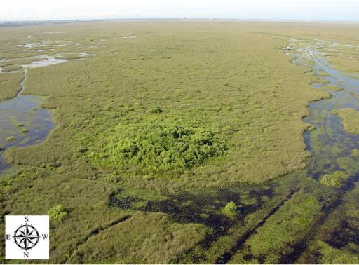
6 What is a Ghost island? Ghost island is a tree island with significant loss in community structure i.e. degraded islands Healthy vegetation. Live island Ghost island Ghost island appears to be just a scar in the landscape. Area with the most number of ghost islands is WCA-2. Today there are only 3 living tree islands in WCA-2.
7 Issues/Concerns Live island Ghost island Can ghost tree islands be restored? Part of the CERP goal: halt tree islands loss by 2020 (1999 Baseline Report for CERP) Eventual goal: restore tree islands in the Everglades
8 Objectives Assess microtopography, soil structure and chemistry, and vegetation patterns of living and ghost tree islands in WCA- 2A. Review aerial imagery to understand trajectory of island loss. Objective: increase understanding of the ecology and biogeochemistry of these islands and how to implement island restoration. Live tree islands Loss of island structure and function Ghost islands RESTORATION

9 Study location in WCA-2A Sampling in WCA 2A across a hydrologic range 10 islands surveyed: 8 ghost + 1 live island,1 additional dying island surveyed Live: 2A Dying: 2A-22-4 North: 2A-22-27, 2A-17-2, 2A Central: 2A-14-2, 2A-16-1 South: 2A-15-6, 2A-12-6,2A-11-1

10 Sampling Design Sampled in transects across the islands based on current discernible extent of island HEAD MIDDLE NEARTAIL Legend: Transect Primary soil sampling locations Pre-impoundment direction of water flow


11 1a. Measuring soil topography Tree island Marsh Open slough PVC sounding rod used to assess elevation every 10 m. Measured from across island from nearest western ridge to eastern ridge.


12 1b. Bedrock topography Tree island Marsh Open slough Metal rod used to assess changes in bedrock every 20 m. 20+ km of transects across 10 islands measured (~2000 shallow and ~1000 deep points measured).
13 Depth relative to surface water level (cm) Results 0 2A-15-6 Dineen s Island Head Western island edge Eastern island edge Distance from historic center of island (m) Average depth to bedrock (all transects): 161 cm Pinnacle rock and elevated soil surfaces observed at the historic center of some island heads (example above).
14 Depth relative to surface water level (cm) Results 0 Dineen s Island Mid-island Western island edge Eastern island edge Distance from historic center of island (m) Limited topographic highs mid-island. No large trees observed, only sawgrass (Cladium jamaicense) and some open water.
15 Depth relative to surface water level (cm) Results 0 Dineen s Island Neartail Western island edge Eastern island edge Distance from historic center of island (m) No large trees and short (<2 m) sawgrass observed.
 0-100 -200 Bedrock Depression 2A-14-2 -300-200 -100 0 100 Head Depth relative to surface water level (cm) 0-100 -200-300 Distance from historic center")
16 Results Data supports the 3 theories of island formation Many islands still show evidence of historic edge boundary Depth relative to surface water level (cm) A Pinnacle rock Head Depth relative to surface water level (cm) Bedrock Depression 2A Head Depth relative to surface water level (cm) Distance from historic center of island (m) 2A No high Head Distance from historic center of island (m) Distance from historic center of island (m)
 HEAD")


17 2. Soil Core Collection Total: 150 short cores collected (15/island) HEAD Cores cut in 2.5 cm intervals for top 10 cm, 5 cm intervals from cm MIDDLE NEARTAIL Parameters analyzed: bulk density, %C, %N, %P, 13 C, 15 N 0-30 cm
 2747 (320) 4091 (369) 1495 (341) 350 (302) Lowest TP = 34 mg/kg (2A-14-2, neartail, 25-30cm) 3664 (415) 7012 (245) Legend: White: island name Blue: island soil TP(mg/kg) Red: slough soil")
18 Results Total Phosphorus distribution in 10 Live and Ghost Tree Islands and the surrounding marsh Island : mg/kg Slough: mg/kg 479 (402) Highest TP = mg/kg (2A-16-1, head, 25-30cm) 2747 (320) 4091 (369) 1495 (341) 350 (302) Lowest TP = 34 mg/kg (2A-14-2, neartail, 25-30cm) 3664 (415) 7012 (245) Legend: White: island name Blue: island soil TP(mg/kg) Red: slough soil TP(mg/kg) 3164 (315) 3237 (267) 3409 (335)

19 Results The Everglades is a Phosphorus-limited system. Phosphorus availability drives productivity. Everglades tree islands are phosphorus hotspots. Island restoration may be more likely if high P is observed. Phosphorus hotspot : TP concentration tree island soils >1000 mg/kg (twice as high as the soil TP concentration in pristine marsh) Two islands did not have a P-hotspot.


 Two Hotspots")
")

20 Fish bones Bird guano Results Eight of the 10 islands had 1 P-hotspots at the head. One Hotspot (n = 2) Two Hotspots (n = 3) Three Hotspots (n = 2) P concentrations increased with depth at the head.


21 3. Vegetation Assessment At soil core collection locations: Average height, dominant species, canopy condition, emergent species, exotics vegetation height, % cover wildlife utilization 450 vegetation samples collected, dried and bagged for nutrient analyses. West Quadrant 5 m North Quadrant 2 m South Quadrant East Quadrant
, bayberry (Myrica cerifera), and sawgrass. Islands with woody species present may have a greater success in being restored. 1.8 m 1.4 m 1.3 m 1.")
22 RESULTS Canopy ranged from 10-20% cover and was 1-2 m tall. Woody species were limited only to the head of the islands. Middle and neartail of islands was sawgrass (13-51% cover). Dominant species were willow (Salix caroliniana), bayberry (Myrica cerifera), and sawgrass. Islands with woody species present may have a greater success in being restored. 1.8 m 1.4 m 1.3 m 1.2 m 0 m 2.7 m 1.1 m 1.8 m 1.2 m Neartail of m Average island vegetation height.
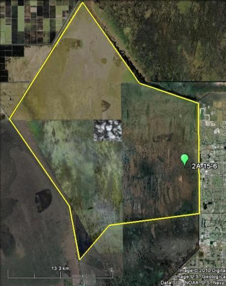
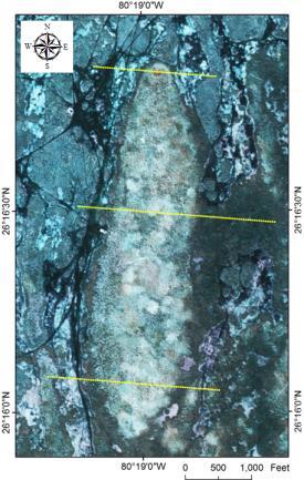
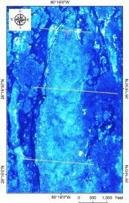
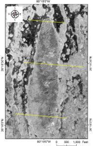
23 4. Aerial Assessment Focused on Dineen s Island (2A-15-6) Examined changes in island extent over time

24 Results: temporal patterns Inter-decadal fluctuations of Dineen s island areal extent observed Eastern boundary appears more dynamic than western edge

25 Temporal patterns Dineen s Island woody tree extent has declined (1940-present) Community phase shifts observed between decades Woody plants throughout island Cattail dominated island Sawgrass dominated island
26 Results 1. Long-term datasets provide insight into shifts in areal extent 2. Community-level changes are clearly captured at decadal time scales Tree island in WCA 3. Note the woody tree extent down the length of the island. Ghost tree island in WCA 2. Note only the trees on the head of island.

 6000 5000 4000 3000 2000 1000 0 Slough west Island west Island center Slough east Island east Island center")
27 Implications for Restoration There is still remnant vegetation and soil microtopography on some ghost islands. Islands with elevated soils and bedrock topography, high TP levels, and with remnant woody vegetation at the head may be suitable for restoration efforts. Restoration efforts have to be accompanied by long-term hydrologic changes. 2A Total P (mg kg -1 ) Slough west Island west Island center Slough east Island east Island center Island east Island west Slough east Slough west Head Mid island Neartail
28 Next step? Identify criterion for successful restoration of drowned ( ghost ) tree islands in WCA 2A. Identify restoration end-points. Implement adaptive restoration practices? Cypress island Live tree islands Loss of island structure and function Ghost islands RESTORATION


29 Acknowledgements E&E Interns and staff: Russel Bahe, Colin Johnson, Robert Sekerka, Joan Altwater SFWMD: Ted Schall, Christopher McVoy, Martha Nungesser, Carlos Coronado, Colin Saunders, Fred Sklar Airboat: J.K. Jones Airboat, Jamie Breig
Landscape-scale trends and. Islands in the Everglades. Sharon M. L. Ewe, Binhe Gu, Jennifer Vega, Kristin Vaughan, Sumanjit Aich
 Landscape-scale trends and patterns of Ghost Tree Islands in the Everglades Sharon M. L. Ewe, Binhe Gu, Jennifer Vega, Kristin Vaughan, Sumanjit Aich What is a Ghost island? Ghost island is a tree island
An evaluation of peat loss from an Everglades tree island, Florida, USA
 An evaluation of peat loss from an Everglades tree island, Florida, USA S. Aich 1, S.M.L. Ewe 2, B. Gu 3 and T.W. Dreschel 3 1 Photo Science Geospatial Solutions, St Petersburg, Florida, USA 2 Ecology
9 th INTECOL Orlando, Florida June 7, 2012
 Restoration of the Everglades Saline Wetlands and Florida Bay: Responses Driven from Land and Sea David Rudnick 1, Colin Saunders 2, Carlos Coronado 2, Fred Sklar 2 Erik Stabenau 1, Vic Engel 1, Rene Price
Ground Water Control of Tree Island Origin, Genesis and Destruction. By John F. Meeder and Peter W. Harlem SERC,FIU
 Ground Water Control of Tree Island Origin, Genesis and Destruction By John F. Meeder and Peter W. Harlem SERC,FIU Functional Definition Our functional definition of a Tree Island is; an isolated scrub
Marl Prairie vegetation response to 20th century land use and its implications for management in the Everglades
 Marl Prairie vegetation response to 20th century land use and its implications for management in the Everglades C. Bernhardt, D. Willard, B. Landacre US Geological Survey Reston, VA USA U.S. Department
The Role of the Mangrove Ecotone Region in Regulating Nutrient Cycling and Wetland Productivity in South Florida
 The Role of the Mangrove Ecotone Region in Regulating Nutrient Cycling and Wetland Productivity in South Florida Victor H. Rivera-Monroy, Stephen E. Davis III, Robert R. Twilley, Daniel L. Childers, Marc
Characterization of Southern Florida Marsh Vegetation Using a Landscape Scale Random Sample: R-EMAP Phase III Vegetation Sampling.
 Characterization of Southern Florida Marsh Vegetation Using a Landscape Scale Random Sample: R-EMAP Phase III Vegetation Sampling. Jennifer H. Richards 1 Tom Philippi 1 P. Kalla 2 and D. Scheidt 3 1 Dept.
Reading the landscape: temporal and spatial changes in a patterned peatland
 Wetlands Ecol Manage (211) 19:475 493 DOI 1.17/s11273-11-9229-z ORIGINAL PAPER Reading the landscape: temporal and spatial changes in a patterned peatland M. K. Nungesser Received: 29 June 29 / Accepted:
A Physical Model of Flow Reconnection to Achieve Ecological Restoration in the Everglades
 A Physical Model of Flow Reconnection to Achieve Ecological Restoration in the Everglades Colin J. Saunders 1, Katherine Skalak 2, Vic Engel 3, Jud Harvey 2, David T. Ho 4, Laurel Larsen 2, Sue Newman
Everglades Ridge, Slough, and Tree Island Mosaics: Year 2 Annual Report
 Florida International University FIU Digital Commons SERC Research Reports Southeast Environmental Research Center 2010 Everglades Ridge, Slough, and Tree Island Mosaics: Year 2 Annual Report Michael S.
DPM Science Team. S. Baisden S. Wilcox N. Garratt D. Crawford T. Kinsey D. George. F. Sklar C. Saunders S. Newman C. Coronado C. Zweig S.
 DPM Science Team F. Sklar C. Saunders S. Newman C. Coronado C. Zweig S. Hagerthey L. Larsen A. Hurst J. Harvey B. Rosen M. Dickman J. Choi J. Lewis E. Tate-Boldt M. Manna E. Cline C. Hansen M. Blaha F.
Connectivity Between the Mangrove Ecotone Region and Florida Bay: Current Understanding in Carbon and Nutrient Fluxes
 Connectivity Between the Mangrove Ecotone Region and Florida Bay: Current Understanding in Carbon and Nutrient Fluxes Victor H. Rivera-Monroy, Stephen E. Davis III, Robert R. Twilley, Daniel L. Childers,
SEAGRASS COVERAGE TRENDS IN THE INDIAN RIVER LAGOON SYSTEM
 Biological Sciences SEAGRASS COVERAGE TRENDS IN THE INDIAN RIVER LAGOON SYSTEM R. W. VIRNSTEIN *,J.S.STEWARD, AND L. J. MORRIS St. Johns River Water Management District, Palatka, FL 32178 ABSTRACT: We
Integrated Ecological Modeling and Decision Analysis within the Everglades Landscape
 Integrated Ecological Modeling and Decision Analysis within the Everglades Landscape GEER 2008 H. Carl Fitz Soil & Water Science Dept., Ft. Lauderdale Research & Education Center Greg Kiker Dept. of Agricultural
Landscape Pattern- Ridge, Slough, and Tree Island Mosaics. Cooperative Agreement #: W912HZ Year-5 Report ( ) Submitted to:
 Submitted to:") Landscape Pattern- Ridge, Slough, and Tree Island Mosaics Cooperative Agreement #: W912HZ-10-2-0030 Year-5 Report (2010-2015) Submitted to: Dr. Glenn Rhett U.S. Army Engineer Research and Development Center
Landscape Pattern- Ridge, Slough, and Tree Island Mosaics Cooperative Agreement #: W912HZ-10-2-0030 Year-5 Report (2010-2015) Submitted to: Dr. Glenn Rhett U.S. Army Engineer Research and Development Center
Landscape Pattern- Ridge, Slough, and Tree Island Mosaics. Cooperative Agreement #: W912HZ Year-3 Report ( ) Submitted to:
 Submitted to:") Landscape Pattern- Ridge, Slough, and Tree Island Mosaics Cooperative Agreement #: W912HZ-10-2-0030 Year-3 Report (2010-2013) Submitted to: Dr. Al F. Cofrancesco U.S. Army Engineer Research and Development
Landscape Pattern- Ridge, Slough, and Tree Island Mosaics Cooperative Agreement #: W912HZ-10-2-0030 Year-3 Report (2010-2013) Submitted to: Dr. Al F. Cofrancesco U.S. Army Engineer Research and Development
Module 3. Basic Ecological Principles
 Module 3. Basic Ecological Principles Ecosystem Components Abiotic Biotic Species & Habitat The Biomes of North America Communities Energy & Matter Cycles in Ecosystems Primary Productivity Simple Ecosystem
Water Management and Hydrology of Northeast Shark River Slough from 1940 to 2015
 Water Management and Hydrology of Northeast Shark River Slough from 1940 to 2015 Greater Everglades Ecosystem Restoration Conference April 2015 Kevin Kotun, Hydrologist Physical Resources Branch South
Native species (Forbes and Graminoids) Less than 5% woody plant species. Inclusions of vernal pools. High plant diversity
 Less than 5% woody plant species. Inclusions of vernal pools. High plant diversity") WILLAMETTE VALLEY WET-PRAIRIE RESTORATION MODEL WHAT IS A WILLAMETTE VALLEY WET-PRAIRIE Hot Spot s Native species (Forbes and Graminoids) Rare plant species Less than 5% woody plant species Often dominated
WILLAMETTE VALLEY WET-PRAIRIE RESTORATION MODEL WHAT IS A WILLAMETTE VALLEY WET-PRAIRIE Hot Spot s Native species (Forbes and Graminoids) Rare plant species Less than 5% woody plant species Often dominated
Flow impacts on P and OM Cycling in the Ridge and Slough:
 Flow impacts on P and OM Cycling in the Ridge and Slough: Lessons from landscape budgets in the Decomp Physical Model and Shark Slough, ENP Colin Saunders South Florida Water Management District Greater
Developed in Consultation with Florida Educators
 Developed in Consultation with Florida Educators Table of Contents Next Generation Sunshine State Standards Correlation Chart... 7 Benchmarks Chapter 1 The Practice of Science...................... 11
Changes in Texas Ecoregions
 Comment On Lesson Changes in Texas Ecoregions The state of Texas can be divided into 10 distinct areas based on unique combinations of vegetation, topography, landforms, wildlife, soil, rock, climate,
CHAPTER 6 & 7 VOCABULARY
 CHAPTER 6 & 7 VOCABULARY 1. Biome 2. Climate 3. Latitude 4. Altitude 5. Emergent layer 6. Epiphyte 7. Understory 8. Permafrost 9. Wetland 10.Plankton 11.Nekton 12.Benthos 13.Littoral zone 14.Benthic zone
Ms. A. Mormando's Class *
 8 th Grade Science Essential Standard: 8.E.1.1 Explain the structure of the hydrosphere including: Water distribution on Earth; Local river basin and water availability Stream - A stream is a body of water
Biodiversity Blueprint Overview
 Biodiversity Blueprint Overview Climate Variability Climate projections for the Glenelg Hopkins Regions suggest that the weather will be hotter and drier in the coming years which will impact on land use,
James B. Heffernan Southeast Environmental Research Center, Department of Biological Sciences, Florida International University
 Florida International University FIU Digital Commons SERC Research Reports Southeast Environmental Research Center 10-21-2009 The Monitoring and Assessment Plan (MAP) Greater Everglades Wetlands Module-
Assessing state-wide biodiversity in the Florida Gap analysis project
 University of Nebraska - Lincoln DigitalCommons@University of Nebraska - Lincoln Nebraska Cooperative Fish & Wildlife Research Unit -- Staff Publications Nebraska Cooperative Fish & Wildlife Research Unit
Climate Outlook through 2100 South Florida Ecological Services Office Vero Beach, FL January 13, 2015
 Climate Outlook through 2100 South Florida Ecological Services Office Vero Beach, FL January 13, 2015 Short Term Drought Map: Short-term (
Ecosystems Chapter 4. What is an Ecosystem? Section 4-1
 Ecosystems Chapter 4 What is an Ecosystem? Section 4-1 Ecosystems Key Idea: An ecosystem includes a community of organisms and their physical environment. A community is a group of various species that
Quantifying effects of oil on coastal dune vegetation. Thomas Miller and Elise Gornish Biological Science, Florida State University
 Quantifying effects of oil on coastal dune vegetation Thomas Miller and Elise Gornish Biological Science, Florida State University Natural History of Barrier Islands in the Northern Gulf Make up ~70% of
EAGLES NEST AND PIASA ISLANDS
 EAGLES NEST AND PIASA ISLANDS HABITAT REHABILITATION AND ENHANCEMENT PROJECT MADISON AND JERSEY COUNTIES, ILLINOIS ENVIRONMENTAL MANAGEMENT PROGRAM ST. LOUIS DISTRICT FACT SHEET I. LOCATION The proposed
SAN FRANCISCO DISTRICT INFORMATION REQUESTED FOR VERIFICATION OF CORPS JURISDICTION
 DEPARTMENT OF THE ARMY SAN FRANCISCO DISTRICT, U.S. ARMY CORPS OF ENGINEERS 1455 MARKET STREET SAN FRANCISCO, CALIFORNIA 94103-1398 SAN FRANCISCO DISTRICT INFORMATION REQUESTED FOR VERIFICATION OF CORPS
Organism Species Population Community Ecosystem
 Name: Date: Period: Ecosystems and Their Interactions S8.B.3.1 Getting the idea The environment is everything that surrounds an organism. Organisms cooperate and compete with each other to get everything
Sediment and nutrient transport and storage along the urban stream corridor
 Sediment and nutrient transport and storage along the urban stream corridor Greg Noe, Cliff Hupp, Ed Schenk, Jackie Batson, Nancy Rybicki, Allen Gellis What is the role of floodplains everywhere? Noe 2013,
Nikki Sacha. NRS 509 Restoration Ecology
 Nikki Sacha NRS 509 Restoration Ecology There were several ways that GIS was incorporated into restoration ecology that was repeated in the eight articles that I reviewed. The first was that it served
Natural Shoreline Landscapes on Michigan Inland Lakes
 Natural Shoreline Landscapes on Michigan Inland Lakes Excerpts from Chapters 2 and 3 Photo Photo by Jane by Jane Herbert Herbert Did you know? Twenty-four species of amphibians, 25 species of reptiles,
Impact & Recovery of Wetland Plant Communities after the Gulf Oil Spill in 2010 and Hurricane Isaac in 2012
 Impact & Recovery of Wetland Plant Communities after the Gulf Oil Spill in 2010 and Hurricane Isaac in 2012 Introduction: The coastal wetlands, estuaries and lagoon systems of the Gulf Coast are a hotspot
Distinct landscape features with important biologic, hydrologic, geomorphic, and biogeochemical functions.
 1 Distinct landscape features with important biologic, hydrologic, geomorphic, and biogeochemical functions. Have distinguishing characteristics that include low slopes, well drained soils, intermittent
Most natural ecosystems are in a state of equilibrium. This means that their biotic and abiotic features remain relatively constant over time.
 Most natural ecosystems are in a state of equilibrium. This means that their biotic and abiotic features remain relatively constant over time. The major biomes, for example, usually maintain a characteristic
The Refugia Concept: Using Watershed Analysis to Prioritize Salmonid Habitat for Conservation and Restoration
 The Refugia Concept: Using Watershed Analysis to Prioritize Salmonid Habitat for Conservation and Restoration Christopher May Battelle & UW Cumulative Impacts of Urbanization Landscape Alterations Loss
ATLSS SESI MODEL: Long-Legged and Short-Legged Wading Birds: Foraging Indices
 ATLSS SESI MODEL: Long-Legged and Short-Legged Wading Birds: Foraging Indices Louis J. Gross, University of Tennessee ATLSS.org Provides a relative estimate of quality of pixels as sites for nesting colonies
Ecological Succession
 Ecological Succession Most natural ecosystems are in a state of equilibrium. This means that their biotic and abiotic features remain relatively constant over time. The major biomes, for example, usually
HISTORICAL DELTA LANDSCAPES Conceptual models for building a diverse and resilient future
 HISTORICAL DELTA LANDSCAPES ITEM REMOVED DUE TO COPYRIGHT STATUS Conceptual models for building a diverse and resilient future Robin Grossinger and Alison Whipple San Francisco Estuary Institute/Aquatic
East Branch Grand Calumet River Great Lakes Legacy Act Sediment Remediation and Restoration Project
 East Branch Grand Calumet River Great Lakes Legacy Act Sediment Remediation and Restoration Project Jointly funded by the U.S. EPA Great Lakes Legacy Act, Indiana Department of Environmental Management
Representative Reference Area Akehurst, Venner meadow, Burnette lake, Fork meadow, paradise meadow, Rimrock swamp, Goose Carex,
 Description This mixed sedge wetland community is the most common wetland type in BC s interior rangelands. These sedge species are able to tolerate anaerobic soil conditions for the entire growing season.
Appendix J Vegetation Change Analysis Methodology
 Appendix J Vegetation Change Analysis Methodology Regional Groundwater Storage and Recovery Project Draft EIR Appendix-J April 2013 APPENDIX J- LAKE MERCED VEGETATION CHANGE ANALYSIS METHODOLOGY Building
3.3 CLIMATE, GEOLOGY, TOPOGRAPHY, AND SOILS CLIMATE GEOLOGY TOPOGRAPHY
 3.3 CLIMATE, GEOLOGY, TOPOGRAPHY, AND SOILS This section describes the climate, geology, topography, and soil resource characteristics of the Yolo Bypass Wildlife Area (Wildlife Area). Agricultural soil
Research Background: Researcher Sam Bond taking Sediment Elevation Table (SET) measurements in the marsh. A view of salt marsh hay growing in a marsh
 measurements in the marsh. A view of salt marsh hay growing in a marsh") Name Keeping up with the sea level Featured scientist: Anne Giblin from the Marine Biological Laboratory and the Plum Island Ecosystems Long-Term Ecological Research site Research Background: Salt marshes
Name Keeping up with the sea level Featured scientist: Anne Giblin from the Marine Biological Laboratory and the Plum Island Ecosystems Long-Term Ecological Research site Research Background: Salt marshes
Taunton River Salt Marsh Assessment Results from 2014 season
 Taunton River Salt Marsh Assessment Results from 2014 season December, 2014 During the late summer and fall of 2014, Save The Bay evaluated salt marshes in Assonet Bay, Freetown and Broad Cove in Dighton
Status of Big Bend oyster populations The view from deep history
 Status of Big Bend oyster populations The view from deep history Greg Herbert School of Geosciences Stephen Hesterberg Integrative Biology Thomas Pluckhahn Department of Anthropology http://myfwc.com/media/4242314/chimmp2017-chapter01-introduction.pdf
Nitrogen and phosphorus dynamics in restored riverine floodplains in intensively managed watersheds
 Nitrogen and phosphorus dynamics in restored riverine floodplains in intensively managed watersheds Sara McMillan 1, Alex Johnson 1, Celena Alford 1, Greg Noe 2, Venkatesh Merwade 1, Sayan Dey, 1 Siddharth
Southwest LRT Habitat Analysis. May 2016 Southwest LRT Project Technical Report
 Southwest LRT Habitat Analysis Southwest LRT Project Technical Report This page intentionally blank. Executive Summary This technical report describes the habitat analysis that was performed to support
COLUSA BASIN WATERSHED ASSESSMENT. Final. Prepared by: H. T. Harvey & Associates. In Collaboration With:
 COLUSA BASIN WATERSHED ASSESSMENT Prepared by: In Collaboration With: G. Mathias Kondolf Geomorph Blankinship & Associates Prepared for: Colusa County Resource Conservation District 100 Sunrise Boulevard,
Long-Term Patterns of Coastal Response to Changing Land Use and Climate: Examples from the Atlantic and Gulf Coastal Plains
 Long-Term Patterns of Coastal Response to Changing Land Use and Climate: Examples from the Atlantic and Gulf Coastal Plains Debra Willard, Christopher Bernhardt, and Miriam Jones U.S. Geological Survey,
Current and Future Technology Applications for Coastal Zone Management. Bruce K. Carlisle, Acting Director Office of Coastal Zone Management
 Current and Future Technology Applications for Coastal Zone Management Bruce K. Carlisle, Acting Director Office of Coastal Zone Management The Massachusetts Coastal Zone Management Program Approved in
GIS Solutions in Natural Resource Management: Balancing the Technical- Political Equation
 GIS Solutions in Natural Resource Management: Balancing the Technical- Political Equation Stan Morain, Editor SUB Gdttlngen 7 208 520 309 98 A14447 0NW0RD PRESS V? % \
BACKWATER RESTORATION OPPORTUNITIES: ILLINOIS RIVER. John C. Marlin
 BACKWATER RESTORATION OPPORTUNITIES: ILLINOIS RIVER John C. Marlin Waste Management and Research Center, Illinois Department of Natural Resources One E. Hazelwood Dr., Champaign, Illinois 61801 E-mail:
Island Design. UMRS EMP Regional Workshop. Presentation for the
 Island Design Presentation for the UMRS EMP Regional Workshop by Jon Hendrickson Hydraulic Engineer Regional Technical Specialist, Water Quality and Habitat Restoration August 17 19, 2005 Project Delivery
Chapter 52 An Introduction to Ecology and the Biosphere
 Chapter 52 An Introduction to Ecology and the Biosphere Ecology The study of the interactions between organisms and their environment. Ecology Integrates all areas of biological research and informs environmental
Resolution XIII.23. Wetlands in the Arctic and sub-arctic
 13th Meeting of the Conference of the Contracting Parties to the Ramsar Convention on Wetlands Wetlands for a Sustainable Urban Future Dubai, United Arab Emirates, 21-29 October 2018 Resolution XIII.23
4.2 Tidal Wetlands. Phragmites Australis
 4.2 Tidal Wetlands Few topics elicit such strong emotions in Guilford as the current state of salt marshes. These marshes, more broadly known as tidal wetlands, are undergoing a transformation as sea level
Use of Bioengineering Techniques for Revegetation of Riparian Areas: Colomac Mine Remediation Project, NWT
 Use of Bioengineering Techniques for Revegetation of Riparian Areas: Colomac Mine Remediation Project, NWT McPherson, M. 1, Vanderspiegel, R. 2, Breadmore, R. 2, and Hewitt, M. 3 2012 RPIC Federal Contaminated
Hydrologic budget of the ORW mitigation wetland, 2002
 Billabong Hydrology 2002 81 Hydrologic budget of the ORW mitigation wetland, 2002 Li Zhang and William J. Mitsch School of Natural Resources, The Ohio State University Introduction Understanding the hydrologic
A Help Guide for Using gssurgo to Find Potential Wetland Soil Landscapes
 A Help Guide for Using gssurgo to Find Potential Wetland Soil Landscapes Wetland Mapping Consortium Webinar September 17, 2014 Dr. John M. Galbraith Crop & Soil Environmental Sciences Virginia Tech Wetland
Chapter 6. Field Trip to Sandia Mountains.
 University of New Mexico Biology 310L Principles of Ecology Lab Manual Page -40 Chapter 6. Field Trip to Sandia Mountains. Outline of activities: 1. Travel to Sandia Mountains 2. Collect forest community
Introduction. Ecology is the scientific study of the interactions between organisms and their environment.
 Introduction Ecology is the scientific study of the interactions between organisms and their environment. 1. The interactions between organisms and their environments determine the distribution and abundance
APPENDIX E. GEOMORPHOLOGICAL MONTORING REPORT Prepared by Steve Vrooman, Keystone Restoration Ecology September 2013
 APPENDIX E GEOMORPHOLOGICAL MONTORING REPORT Prepared by Steve Vrooman, Keystone Restoration Ecology September 2 Introduction Keystone Restoration Ecology (KRE) conducted geomorphological monitoring in
Evapotranspiration Estimation for South Florida
 Technical Paper EMA # 407 (for presentation and publication in a proceedings of the World Water and Environmental Resources Congress 2003, Symposium on Integrated Surface and Groundwater Modeling, ASCE
9/10/ What Shapes an Ecosystem? Biotic and Abiotic Factors
 9/10/14 4-2 What Shapes an Ecosystem? Biology 1 of 39 Ecosystems are influenced by a combination of biological and physical factors. The biological influences on organisms within an ecosystem are called
Climate Outlook through 2100 South Florida Ecological Services Office Vero Beach, FL September 9, 2014
 Climate Outlook through 2100 South Florida Ecological Services Office Vero Beach, FL September 9, 2014 Short Term Drought Map: Short-term (
ADDRESSING GEOMORPHIC AND HYDRAULIC CONTROLS IN OFF-CHANNEL HABITAT DESIGN
 ADDRESSING GEOMORPHIC AND HYDRAULIC CONTROLS IN OFF-CHANNEL HABITAT DESIGN Conor Shea - Hydrologist U.S. Fish and Wildlife Service Conservation Partnerships Program Arcata, CA Learning Objectives Examine
InSAR-based hydrology of the Everglades, South Florida
 InSAR-based hydrology of the Everglades, South Florida Shimon Wdowinski (1), Falk Amelung (1), Fernando Miralles-Wilhelm (2), Tim Dixon (1), and Richard Carande (3) (1) Division of Marine Geology and Geophysics,
APPENDIX D: WATER CONSERVATION AREA NO. 3, EVERGLADES NATIONAL PARK AND EVERGLADES NATIONAL PARK-SOUTH DADE CONVEYANCE SYSTEM OPERATIONAL GUIDANCE
 APPENDIX D: WATER CONSERVATION AREA NO. 3, EVERGLADES NATIONAL PARK AND EVERGLADES NATIONAL PARK-SOUTH DADE CONVEYANCE SYSTEM OPERATIONAL GUIDANCE DRAFT CSSS Operational Guidance for Water Conservation
How Do Human Impacts and Geomorphological Responses Vary with Spatial Scale in the Streams and Rivers of the Illinois Basin?
 How Do Human Impacts and Geomorphological Responses Vary with Spatial Scale in the Streams and Rivers of the Illinois Basin? Bruce Rhoads Department of Geography University of Illinois at Urbana-Champaign
Chapter 7 Case study. Sand dune coastal environment: Studland Bay
 Sand dune coastal environment: Studland Bay Sand dunes are common features of low-lying stretches of coastline in the UK and elsewhere in the world. They form in places where there is a plentiful supply
VEGETATION EVA BOEHRINGER
 VEGETATION EVA BOEHRINGER April 2, 2014 WUP CONSULTATIVE COMMITTEE WUP Consultative Committee (WUP CC) recognized that riparian and wetland vegetation in the reservoir drawdown zone is valuable for fish,
Modeling Hydrodynamic Effects and Salinity Intrusion. Presented by Dr. Eric Swain, USGS Water Science Center, Fort Lauderdale Florida
 Modeling Hydrodynamic Effects and Salinity Intrusion Presented by Dr. Eric Swain, USGS Water Science Center, Fort Lauderdale Florida Requirements Because coastal South Florida has unique features such
Appendix I Feasibility Study for Vernal Pool and Swale Complex Mapping
 Feasibility Study for Vernal Pool and Swale Complex Mapping This page intentionally left blank. 0 0 0 FEASIBILITY STUDY BY GIC AND SAIC FOR MAPPING VERNAL SWALE COMPLEX AND VERNAL POOLS AND THE RESOLUTION
Overview of Methods. Terrestrial areas that are most important for conservation Conservation
 Overview of Methods The goal of the Western Lake Erie Coastal Conservation Vision project (WLECCV) is to define where we should be working locally to optimally achieve regional conservation impact. The
GIS and Coastal Nutrients Luke Cole
 GIS and Coastal Nutrients Luke Cole Human population density has been widely utilized as a valid predictor of terrestrial nitrogen loads into marine systems. As 50% of the world s population lives within
Environmental Science
 Environmental Science A Study of Interrelationships Cui Jiansheng Hebei University of Science and Technology CH06 Kinds of Ecosystems and Communities Chapter Objectives After reading this chapter, you
Biosphere Biome Ecosystem Community Population Organism
 Ecology ecology - The study of living things and how they relate to their environment Levels of Organization in Ecology organism lowest level one living thing population collection of organisms of the
The mapping of habitats: an indispensable tool to the planning and management of protected areas in Catalonia
 The mapping of habitats: an indispensable tool to the planning and management of protected areas in Catalonia Palau de Congressos de Catalunya Barcelona, 27 September 2016 Introduction Agoodcartographic
Wetland & Estuarine Formation & Development NREM 665
 Wetland & Estuarine Formation & Development NREM 665 1 I. Wetland Formation & Development A. Favorable climate (PPT > ET), temperature 1. don t get WTLs in B. Favorable geol/substrate 1. high H 2 O holding
4-2 What Shapes an Ecosystem? Slide 1 of 39
 4-2 What Shapes an Ecosystem? 1 of 39 Biotic and Abiotic Factors Biotic and Abiotic Factors Ecosystems are influenced by a combination of biological and physical factors. The biological influences on organisms
Everglades National Park
 National Park Service U.S. Department of the Interior Water Budget, Climate Variability, and Predicting Salinity for Eastern Florida Bay Erik Stabenau and Kevin Kotun National Park Service Erik_Stabenau@nps.gov
Kyoto and Carbon Initiative - the Ramsar / Wetlands International perspective
 Kyoto and Carbon Initiative - the Ramsar / Wetlands International perspective (the thoughts of Max Finlayson, as interpreted by John Lowry) Broad Requirements Guideline(s) for delineating wetlands (specifically,
PLANT COMMUNITY COMPOSITION OF THE BUCKTOWN CREATED MARSH:
 PLANT COMMUNITY COMPOSITION OF THE BUCKTOWN CREATED MARSH: A PRELIMINARY ASSESSMENT Prepared for: John Lopez, Director Coastal Sustainability Program Lake Pontchartrain Basin Foundation Prepared by: Mark
MEMORANDUM FOR SWG
 MEMORANDUM FOR SWG-2007-1623 Subject: Jurisdictional Determination (JD) for SWG-2007-1623 on Interdunal Wetlands Adjacent to Traditional Navigable Waters (TNWs) Summary The U.S. Environmental Protection
Kakagon Sloughs, Bad River Reservation 1980s Jim Meeker, Northland College
 Natural history of coastal wetlands in the greater Chequamegon Bay region Kakagon Sloughs, Bad River Reservation 1980s Jim Meeker, Northland College small large northern Great Lake wetlands are dominated
4-2 What Shapes an Ecosystem?
 Biology 1 of 39 4-2 What Shapes an Ecosystem? 2 of 39 Biotic and Abiotic Factors Biotic and Abiotic Factors Ecosystems are influenced by a combination of biological and physical factors. 3 of 39 1 Biotic
Shoreline Mapping & Erosion Patterns. Julia Knisel Julia Knisel Coastal Shoreline & Floodplain Manager
 Shoreline Mapping & Erosion Patterns Along the Massachusetts Coast Julia Knisel Julia Knisel Coastal Shoreline & Floodplain Manager CZM Shoreline Change Project Timeline 1989: produced coast wide maps
Creating ponds for Marsh Clubmoss Lycopodielle inundata
 Creating ponds for Marsh Clubmoss Lycopodielle inundata Freshwater Habitats Trust 1. What is Marsh Clubmoss? Marsh Clubmoss Lycopodiella inundata is not a true moss but a primitive non-flowering plant
Sea Level Rise in Miami-Dade County Florida Implications for Management of Coastal Wetlands and the Everglades
 Sea Level Rise in Miami-Dade County Florida Implications for Management of Coastal Wetlands and the Everglades Peter W. Harlem Dr. John F. Meeder Florida International University Southeast Environmental
Shallow Karst Aquifer System of the Lake Belt Study Area, Miami-Dade County, Florida, USA EXTENDED ABSTRACT
 Second International Conference on Saltwater Intrusion and Coastal Aquifers Monitoring, Modeling, and Management. Merida, Mexico, March 30 April 2, 2003 Shallow Karst Aquifer System of the Lake Belt Study
Name Hour. Chapter 4 Review
 Name Hour Chapter 4 Review 1. The average, year-after-year conditions of temperature and precipitation within a particular region are its weather. climate. greenhouse effect. d. biotic factors. 2. The
Removal of riverbank protection along the River Rhine (the Netherlands)
") RR 2004 3rd European Conference on River Restoration RIVER RESTORATION 2004 Zagreb, Croatia, 17-21 May 2004 Removal of riverbank protection along the River Rhine (the Netherlands) L.J. Bolwidt, H.E.J.
RR 2004 3rd European Conference on River Restoration RIVER RESTORATION 2004 Zagreb, Croatia, 17-21 May 2004 Removal of riverbank protection along the River Rhine (the Netherlands) L.J. Bolwidt, H.E.J.
Mangrove Restoration and Migration in a Changing Climate: Climatic Drivers and Shifting Ecotones
 Mangrove Restoration and Migration in a Changing Climate: Climatic Drivers and Shifting Ecotones Michael J. Osland & Richard H. Day U.S. Geological Survey, National Wetlands Research Center U.S. Department
BIO B.4 Ecology You should be able to: Keystone Vocabulary:
 Name Period BIO B.4 Ecology You should be able to: 1. Describe ecological levels of organization in the biosphere 2. Describe interactions and relationships in an ecosystem.. Keystone Vocabulary: Ecology:
The following maps must be provided as a part of the ADA. The appropriate scale for each map should be determined at the pre application conference.
 Main Street @ Coconut Creek DRI QUESTION 9 MAPS The following maps must be provided as a part of the ADA. The appropriate scale for each map should be determined at the pre application conference. Map