Geology Setting Management Options Management Structure
|
|
|
- Amy Ball
- 5 years ago
- Views:
Transcription
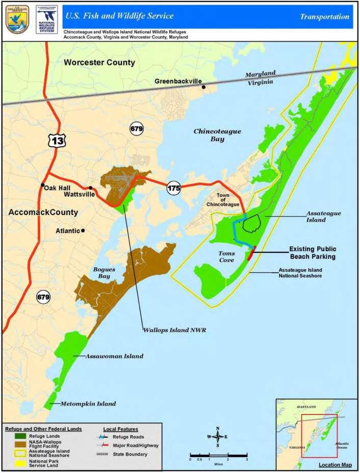
1 Geology Setting Management Options Management Structure WFF = Wallops Flight Facility LST = Longshore sediment transport SLR = Sea level rise September 29, 2015
2 Accomack County/Accomack Northampton County PDC Town of Chincoteague The Nature Conservancy NASA Wallops Fish and Wildlife Service National Park Service Commonwealth of Virginia US Army Corps of Engineers Bureau of Ocean Energy Management
3 2010-Eastern Shore Climate Adaptation Working Group (CAWG) TNC/ANPDC Two year Grant- Hurricane Sandy Coastal Resilience Funds to enhance coastal resilience from NFWF, Dept of the Interior MACRI Mid-Atlantic Coastal Resilience Institute MARCO- Mid-Atlantic Council on the Ocean, E. Shore North coast SAMP (Special Area Management Plan) UVA- Long-term Ecological Research Project (LTER) 2015 FWS Chinocteague and Wallops Island NWR Final Comprehensive Conservation Plan, CCP NASA Wallops Environmental Assessments for Shore projects NASA Goddard Space Flight Center (GSFC); WFF and Marine Science Consortium (MSC) Research Collaboration.

4 Wallops Assateague Chincoteague Inlet (WACI) Coastal Management Reach Fenster and Bundick 2015
5 Geologic/Physical Setting/shore change: Cape Henlopen to Cape Charles Coastal plain structure a function of oceanic transgression/regression Wisconsin: Latest SLR Assateague Island Shore change Inlet history Wallops Island NASA History of shore management Sandy Impact Chincoteague Inlet Geomorphic development Hydrodynamic Setting: Sea level rise, wave climate
6

7 1. mixed-energy, tide dominated Barrier islands 2. wave-dominated barriers an spits 3. Eroding headlands 4. Cuspate spits Mcbride et al. 2013
8 Basic sediment transport Pathways for barrier islands Along the mid-atlantic coast Modified from Kraft et al 1987, In Rankin 2009.

9 Coastal Plain stratigraphy Coastal plain terraces. Much of Chesapeake Bay was Incised after the Yorktown marine transgression (Ty) Johnson et al 1999

10 Depositional model of surficial Pleistocene deposit In the Delmarva Penisula. Jordan 1962

11 A reconstruction of early Holocene paleogeography of the Delmarva Coastal Plain (Oertel, Allen, & Foyle, 2008)

12 Extent of last glaciation 20,000 years BP. Sea level 400 ft lower Mid-Atlantic coastline 65 miles to east FEMA 2011 Hazard Mitigation Plan Va E.Shore

13 Canada Virginia Earth Crust During the last ice age Glacial rebound in northern US/Canada causing local subsidence As the glaciers melted...

14 Coleman et al 1990
15 Kraft 1971
16 McBride et al 2013

17 Delmarva North: Cape Henlopen To Fishing Point Hapke et al 2010

18 Did lack of inlets by 1880 allow for increased LST to the south and Creation of Fishing Point? From Seminack and McBride, 2015


19 Historic Inlets along Assateague Island Seminack and Mcbridge 2015


20 Spit evolution And creation of CCP May 2014

21 CCP May 2014

22 FWS CCP May 14

23 Proposed Beach fill: 1.5 million $24 million Re-nourish every 3-7 years: 300,000 $8.3 million Appendix J CCP May 2014

24 Proposed area of beach location Looking north: Note fence posts along Top of dune from past dune Stabilization efforts Hardaway

25 Proposed beach re-location: Looking north Hardaway

26 King et al., 2011
27 According to Field, 1980, the linear offshore ridges may be relict Or stranded shoreline features from lower stand of sea level. There is further evidence that the ridges might migrate with time, Southward and often due to storms. Field 1980

28 Extensive offshore shoals: many sand Rich and potential source of beach sand. The black dots indicate fine-medium Sand thicknesses of > 3 m. Field 1980

29 Delmarva South Wallops Island To Cape Charles Hapke et al 2010

30 Note: ebb shoals at each inlet which interrupt LST Fenster and Bundick 2015

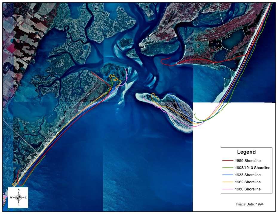
31 The following series Shows the growth of Fishing point and the Did closure of most inlet On Assateague Island
32
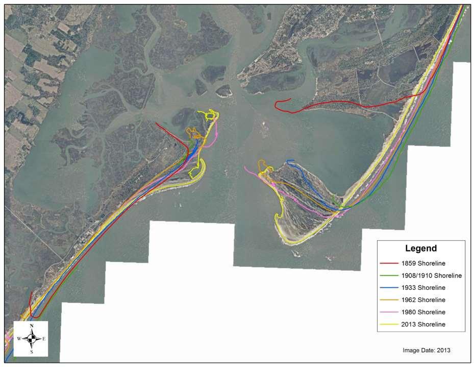
33

34 King et al., 2011


35 Wallops Island December 1959 Wallops Island Seawall October 1956


36 Mechanically filled section at Wallops Island after the Ash Wednesday Storm Breach Wallops Island Groin Field 1969

37 Evolution of Assawoman Inlet Fenster and Bundick, 2015

38 Did closure of Assawoman Inlet allows for increased LST? Fenster and Bundick, 2015
39 Sediment Budget Analysis Current LST predictions (1986 Morang 2006 (frommn 1986)
40

41 King et al 2011 GENESIS wave model

42 Dominant waves attack From NE quad King et al., 2011

43 Result of GENESIS modeling Note: LST nodal zone After King et 2011

44 Wallops Island 2012 Pre-Beach Fill

45 King et al., 2011

46 Conceptual Initial Fill Placement Conceptual Renourishment Fill Placement King et al., 2011
47 Beach fill = about 4.0 million cy from the larger fill in 2012 (3.2 million cy) and in 2014 (0.7 million cy).

48 Beach loss due to Sandy = About 800,000 cy Losses offshore and landward as well as along shore.

49 NASA, 2013 Typical beach profile at WFF: before and after placement; post- Sandy

50 WFF Looking south at washover And old Assawoman Inlet Hardaway Feb 2013

51 WFF looking south, Post-Sandy Feb 2013

52 WFF looking south, USACE, 2015

53 WFF looking south, USACE 2015
54 WACI Alongshore sediment characteristics According to Moffatt Nickol about 5% Of LST from Ass Is bypasses Chino Inlet Shoal gets to Wallops Is. Figure from: Fenster and Bundick 2015

55 Chincoteague Inlet 1949 Aerial Photo

56 Chincoteague Inlet Navigation Channel Showing infilling From shoal on Fishing Point Side of channel

57 Chincoteague Inlet dredging history. Morang et al., 2006
58 Management Elements WACI: Wallops Island, Assateague Island and Chincoteague Inlet Wallops Island: Shore protection efforts Assateague Island: public Isthmus Chincoteague Inlet dredging, harbor of refuge Toms Cove aquaculture
59 CCRM 2013

60 Curt Smith 2015

61 Curtis Smith 2015
62 Beach nourishment has been Removed from consideration
63 CC[c C C

64 State subaqueous resources
65 2010-Eastern Shore Climate Adaptation Working Group (CAWG) TNC/ANPDC Two year Grant- Hurricane Sandy Coastal Resilience Funds to enhance coastal resilience from NFWF, Dept of the Interior MACRI Mid-Atlantic Coastal Resilience Institute MARCO- Mid-Atlantic Council on the Ocean, E. Shore North coast SAMP (Special Area Management Plan) UVA- Long-term Ecological Research Project (LTER) 2015 FWS Chinocteague and Wallops Island NWR Final Comprehensive Conservation Plan, CCP NASA Wallops Environmental Assessments for Shore projects NASA Goddard Space Flight Center (GSFC); WFF and Marine Science Consortium (MSC) Research Collaboration.
66 On Assateague Island: What it the long term plan for the new beach? Will allowing inlets/breaches to remain open along Assateague Is reduce LST and threatened the Will WFF beach fill increase shoaling in Chincoteague Inlet? What is the contribution (s) of LST into Chinoteague Inlet? How was Chincoteague Inlet formed? Can Chincoteague Inlet dredge material be put on shore either at WFF or Assateague Is? How can the fines be utilized? Thin layering across tidal marsh? What are LST impacts of WFF beach fill to Assawoman Is and backbarrier marshes? Is back passing WFF beach a viable option?
67
Primer on Coastal Erosion And Habitat Creation
 2 nd Regional Conference Dredging, Beach Nourishment & Bird Conservation Primer on Coastal Erosion And Habitat Creation Timothy Kana Ph.D Source: Newsday 1962 Photo by Kelsey Aerials 1978 Source: U Mass
Mapping, monitoring, and modeling: USGS Coastal and Marine Geology activities along the Northeast coast
 Mapping, monitoring, and modeling: USGS Coastal and Marine Geology activities along the Northeast coast Coastal and Marine Geology Program Woods Hole Coastal and Marine Science Center St. Petersburg Coastal
Sediment Management in the Coastal Bays
 Sediment Management in the Coastal Bays Introduction Need for ecosystem view of sediment management in Coastal Bays Island loss and restoration Navigation needs Habitat Trade offs Living Shoreline Requirements
The Coast: Beaches and Shoreline Processes
 1 2 3 4 5 6 7 8 9 The Coast: es and Shoreline Processes Trujillo & Thurman, Chapter 10 Oceanography 101 Chapter Objectives Recognize the various landforms characteristic of beaches and coastal regions.
The Coast: Beaches and Shoreline Processes Trujillo & Thurman, Chapter 10
 The Coast: es and Shoreline Processes Trujillo & Thurman, Chapter 10 Oceanography 101 Chapter Objectives Recognize the various landforms characteristic of beaches and coastal regions. Identify seasonal
Geol 117 Lecture 18 Beaches & Coastlines. I. Types of Coastlines A. Definition:
 I. Types of Coastlines A. Definition: 1. Shore = narrow zone where ocean meets land (e.g. beach) 2. Coast is a broad area where both ocean and land processes act a. Includes onshore marshes, dunes, sea
Coastal Inlets Research Program US Army Corps of Engineers Engineering Research and Development Center
 Coastal Inlets Research Program US Army Corps of Engineers Engineering Research and Development Center Site of Moriches Inlet Nov. 1951 Julie Dean Rosati and Nicholas C. Kraus, CIRP Program Manager Shinnecock
The U.S. Army Corps of Engineers Philadelphia District
 The U.S. Army Corps of Engineers Philadelphia District The Atlantic Coast of New Jersey Regional Sediment Budget 1986-2003 Cape May Point to Manasquan Inlet Final Report March 2006 The Atlantic Coast of
Sea-level Rise on Cape Cod: How Vulnerable Are We? Rob Thieler U.S. Geological Survey Woods Hole, MA
 Sea-level Rise on Cape Cod: How Vulnerable Are We? Rob Thieler U.S. Geological Survey Woods Hole, MA Outline Sea-level and coastal processes Past sea-level change Predictions for the future Coastal responses
MODELING OF EROSION CONTROL ALTERNATIVES AT STUMP PASS, CHARLOTTE COUNTY
 2014 NATIONAL CONFERENCE ON BEACH PRESERVATION TECHNOLOGY FEBRUARY 13, 2014 MODELING OF EROSION CONTROL ALTERNATIVES AT STUMP PASS, CHARLOTTE COUNTY 1 VADIM ALYMOV, PH.D. 2 CHUCK MOPPS 3 MICHAEL POFF,
Coastal Processes 101. Greg Berman (Woods Hole Sea Grant & Cape Cod Cooperative Extension)
") Coastal Processes 101 Greg Berman (Woods Hole Sea Grant & Cape Cod Cooperative Extension) January 23, 2019 Coastal Processes 101 Outline: ~30 min talk Coastal Processes What is Erosion? Value of the Ecosystem
Coastal Processes 101 Greg Berman (Woods Hole Sea Grant & Cape Cod Cooperative Extension) January 23, 2019 Coastal Processes 101 Outline: ~30 min talk Coastal Processes What is Erosion? Value of the Ecosystem
Sea-level Rise and Storm Effects on Coastal Systems under Changing Global Climate. Cape May, NJ 12 January 2009
 Sea-level Rise and Storm Effects on Coastal Systems under Changing Global Climate 2009 Delaware Estuary Science Summit Cape May, NJ 12 January 2009 S. Jeffress Williams Senior Coastal Marine Geologist
SHORELINE BEHAVIOR ALONG THE ATLANTIC COAST OF DELAWARE
 Middle States Geographer, 2008, 41:74-81 SHORELINE BEHAVIOR ALONG THE ATLANTIC COAST OF DELAWARE Francis A. Galgano Jr. Department of Geography and the Environment Villanova University Villanova, Pennsylvania
Linking Inlet Hydrodynamics and Morphologic Response at Oregon Inlet, NC
 Linking Inlet Hydrodynamics and Morphologic Response at Oregon Inlet, NC Prepared for: Sharon Ahlers Engineering Communications Program Cornell University Prepared by: Justin Vandever School of Civil and
EAST PASS UP-DATE SUMMARY OF FINDINGS REPORT and INLET MANAGEMENT IMPLEMENTATION PLAN
 EAST PASS 2013 UP-DATE SUMMARY OF FINDINGS REPORT and INLET MANAGEMENT IMPLEMENTATION PLAN Introduction On June 8, 2000, the Florida Department of Environmental Protection adopted the East Pass Inlet Management
2.2.7 Backbarrier flats
 FIGURE 24. VERTICAL PHOTOGRAPH SHOWING THE DEVELOPMENT OF SMALL PARABOLIC DUNES FROM BLOWOUTS IN A LARGE RELICT FOREDUNE NORTHWEST OF HUNTER'S CREEK. PHOTOGRAPH COURTESY OF CAR'T'ER HOLT HARVEY FORESTS
GenCade. Combining and Extending the GENESIS and Cascade Models for Planning and Design in a Regional Sediment Management Framework
 GenCade Combining and Extending the GENESIS and Cascade Models for Planning and Design in a Regional Sediment Management Framework G Presented by Nicholas C. Kraus For the GenCade Development Team Ken
Donald K. Stauble and Bill Birkemeier Coastal and Hydraulics Laboratory US Army Corps of Engineers
 Donald K. Stauble and Bill Birkemeier Coastal and Hydraulics Laboratory US Army Corps of Engineers Define the Problem Navigation Shore Protection Environmental Political So what is the problem? Management
A SEDIMENT BUDGET ANALYSIS AND MANAGEMENT STRATEGY FOR FORT PIERCE INLET, FL
 A SEDIMENT BUDGET ANALYSIS AND MANAGEMENT STRATEGY FOR FORT PIERCE INLET, FL By Elba Rodriguez and Robert G. Dean Department of Civil and Coastal Engineering University of Florida Gainesville, FL 32611,
Coastal Processes and Shoreline Erosion on the Oregon Coast, Cascade Head to Cape Kiwanda
 State of Oregon Department of Geology and Mineral Industries Vicki S. McConnell, State Geologist Open File Report OFR O-04-11 Coastal Processes and Shoreline Erosion on the Oregon Coast, Cascade Head to
Regional-scale understanding of the geologic character and sand resources of the Atlantic inner continental shelf, Maine to Virginia
 Regional-scale understanding of the geologic character and sand resources of the Atlantic inner continental shelf, Maine to Virginia Workshop on Dredging, Beach Nourishment and Bird Conservation Atlantic
ON THE EVOLUTION OF A HOLOCENE BARRIER COAST
 ON THE EVOLUTION OF A HOLOCENE BARRIER COAST Response to sea-level change and sediment supply DANCORE Seminar 2014 COADAPT - Danish Coasts and Climate Adaptation Flooding Risk and Coastal Protection Mikkel
Coastal Processes 101 & The Regs. Greg Berman (Woods Hole Sea Grant & Cape Cod Cooperative Extension)
") Coastal Processes 101 & The Regs Greg Berman (Woods Hole Sea Grant & Cape Cod Cooperative Extension) March 26, 2019 Coastal Processes 101 & The Regs Outline: ~15 min talk Coastal Processes What is Erosion?
Coastal Processes 101 & The Regs Greg Berman (Woods Hole Sea Grant & Cape Cod Cooperative Extension) March 26, 2019 Coastal Processes 101 & The Regs Outline: ~15 min talk Coastal Processes What is Erosion?
DIVISION OF COASTAL MANAGEMENT TO STUDY CURRENT LONG-TERM EROSION RATES ADJACENT TO TERMINAL GROINS
 DIVISION OF COASTAL MANAGEMENT TO STUDY CURRENT LONG-TERM EROSION RATES ADJACENT TO TERMINAL GROINS North Carolina Department of Environmental Quality Division of Coastal Management February 22, 2018 N.
ENGINEERING APPROACHES TO SHORELINE PLACEMENT FROM COAST TO COAST
 ENGINEERING APPROACHES TO SHORELINE PLACEMENT FROM COAST TO COAST 237 237 237 217 217 217 200 200 200 0 0 0 163 163 163 131 132 122 80 119 27 252 174.59 83 36 118 110 135 120 112 92 56 62 102 130 Comparing
Monitoring Shoreline Change along Assateague Barrier Island: The First Trend Report
 Journal of Coastal Research SI 64 8-84 ICS211 (Proceedings) Poland ISSN 749-28 Monitoring Shoreline Change along Assateague Barrier Island: The First Trend Report N. P. Psuty and T. M. Silveira Marine
Regional Sediment Management
 Regional Sediment Management Linda S. Lillycrop Program Manager Coastal Engineer US Army Engineer Research and Development Center Coastal and Hydraulics Laboratory Q AVG Coastal Resilience: The Environmental,
The Marine Environment
 The Marine Environment SECTION 16.1 Shoreline Features In your textbook, read about erosional landforms, beaches, estuaries, longshore currents, and rip currents. For each statement below, write true or
An overview of USGS Hurricane Sandy Supplemental Studies along the Delmarva Peninsula
 An overview of USGS Hurricane Sandy Supplemental Studies along the Delmarva Peninsula Neil K. Ganju, Laura L. Brothers, Nathaniel G. Plant, Christopher G. Smith, E. Robert Thieler Coastal and Marine Geology
SHORELINE AND BEACH PROCESSES: PART 2. Implications for Coastal Engineering
 SHORELINE AND BEACH PROCESSES: PART 2 Implications for Coastal Engineering Objectives of the lecture: Part 2 Show examples of coastal engineering Discuss the practical difficulties of ocean engineering
MISSISSIPPI COASTAL IMPROVEMENTS
 MISSISSIPPI COASTAL IMPROVEMENTS PROGRAM (MsCIP) Comprehensive Barrier 237 27 200 237 27 200 Island 237 Restoration 27 200 Plan 80 9 27 252 74.59 255 255 255 0 0 0 63 63 63 3 32 22 239 65 53 0 35 20 2
Supplemental Slides. Shore: Junction of Land & Water. Junction of Land & Water. Sea Level Variations. Shore vs. Coast. Sea Level Variations
 Shore: Junction of Land & Water Supplemental Slides Sediments come off land Most get dumped at the beach Sediment interacts with ocean waves and currents Junction of Land & Water Features: Breaking waves,
Shore: Junction of Land & Water. Sediments come off land Most get dumped at the beach Sediment interacts with ocean waves and currents
 Shore: Junction of Land & Water Supplemental Slides Sediments come off land Most get dumped at the beach Sediment interacts with ocean waves and currents Junction of Land & Water Features: Breaking waves,
Pinellas, Manatee, and Sarasota Counties, Florida; Regional Sediment Budget
 Pinellas, Manatee, and Sarasota Counties, Florida; Regional Sediment Budget by Kelly R. Legault and Ashley E. Frey PURPOSE: This U.S. Army Corps of Engineers (USACE) Regional Sediment Management Technical
Tony Pratt, DNREC to The Center for the Inland Bays Scientific and Technical Advisory Committee. August 21, 2009
 Sea Level Rise in Delaware Presented by Tony Pratt, DNREC to The Center for the Inland Bays Scientific and Technical Advisory Committee August 21, 2009 Sea level has been fluctuating ever since there have
EARTH SURFACE PROCESSES AND SEDIMENTATION!
 Sed and Strat EARTH SURFACE PROCESSES AND SEDIMENTATION! 2/27 Lecture 7- Exposure: Weathering and the Sediment Factory 3/04 Lecture 8 - Rivers and Landscapes 3/06 Lecture 9 - Waves (not Tides) 3/11 Lecture
In 1990, 50% of the U.S. population lived within 75 km of a coast. By 2010, 75% of the U.S. population will live within 75 km of a coast.
 In 1990, 50% of the U.S. population lived within 75 km of a coast. By 2010, 75% of the U.S. population will live within 75 km of a coast. High Tech Methods for Surveying the Deep Sea Floor Fig. 20.18 1
ST. LUCIE COUNTY, FLORIDA
 ST. LUCIE COUNTY, FLORIDA COASTAL STORM RISK MANAGEMENT PROJECT DRAFT INTEGRATED FEASIBILITY STUDY AND ENVIRONMENTAL ASSESSMENT APPENDIX D Geotechnical APRIL 2016 TABLE OF CONTENTS 1 Background... 3 1.1
KEYWORDS: erosion shoreline change nourishment community issues
 UNC Coastal Studies Institute 1 TITLE: Sand, Soil, Sediment Selection for Beach Nourishment KEYWORDS: erosion shoreline change nourishment community issues ABSTRACT: North Carolina s barrier islands are
Active Coastal Processes in the Lubec Embayment
 The Lubec Embayment Maine Geologic Facts and Localities August, 1998 Active Coastal Processes in the Lubec Embayment 44 49 50.51 N, 66 59 34.16 W Text by Joseph T. Kelley, Department of Agriculture, Conservation
The Geology of Sebago Lake State Park
 Maine Geologic Facts and Localities September, 2002 43 55 17.46 N, 70 34 13.07 W Text by Robert Johnston, Department of Agriculture, Conservation & Forestry 1 Map by Robert Johnston Introduction Sebago
Planning for the Future of Humboldt Bay: Sea Level Rise, Sediment Management, Sand Spits and Salt Marshes. Joel Gerwein
 Planning for the Future of Humboldt Bay: Sea Level Rise, Sediment Management, Sand Spits and Salt Marshes Joel Gerwein Introduction to Humboldt Bay Setting Economy, community, and environment Sediment
Professors Dean and Dalrymple are also authors of the well-known Water Wave Mechanics for Engineers and Scientists.
 COASTAL PROCESSES The world s coastlines, dividing land from sea, are geological environments unique in their composition and the physical processes affecting them. Humans have been building structures
The Marine Environment
 The Marine Environment SECTION 16.1 Shoreline Features In your textbook, read about erosional landforms, beaches, estuaries, longshore currents, and rip currents. For each statement below, write or. 1.
Alexandra Carvalho, Ph.D., GISP Kathy Fitzpatrick, P.E.
 Coastal Data Organization for Project Management and Coastal Planning Martin County, Florida Alexandra Carvalho, Ph.D., GISP Kathy Fitzpatrick, P.E. Outline County Coastal Programs Coastal Geodatabase
Coastal Sediment Properties and Longshore Sediment Transport
 Coastal Sediment Properties and Longshore Sediment Transport Julie Rosati Julie.D.Rosati@erdc.usace.army.mil 601-634-3005 Coastal Planning Course Lesson #8 Tuesday 8:00-9:00 am CEM III-1, III-2 1. Coastal
Mark H. Horwitz Ping Wang PhD Coastal Research Laboratory, School of Geosciences University of South Florida
 Mark H. Horwitz Ping Wang PhD Coastal Research Laboratory, School of Geosciences University of South Florida American Shore & Beach Preservation Association 2015 National Coastal Conference, New Orleans,
RESULTS FROM THE TEXAS COASTAL SEDIMENT SOURCES: A GENERAL EVALUATION STUDY
 RESULTS FROM THE TEXAS COASTAL SEDIMENT SOURCES: A GENERAL EVALUATION STUDY JUAN MOYA KELSEY CALVEZ CRIS WEBER ANTHONY RISKO *KEVIN FRENZEL FREESE AND NICHOLS, INC. COASTAL AND WATERWAYS GROUP OBJECTIVES
COASTAL GEOLOGIC HAZARDS AND SEA-LEVEL RISE: CLIMATE CHANGE IN RHODE ISLAND
 COASTAL GEOLOGIC HAZARDS AND SEA-LEVEL RISE: CLIMATE CHANGE IN RHODE ISLAND Sakonnet Preservation Association Annual Meeting 9 July 2013 Jon C. Boothroyd 1,2 and Bryan A. Oakley 3 (1) Rhode Island Geological
Importance of Understanding Coastal Landforms
 Importance of Understanding Coastal Landforms Costa Concordia Shipwreck, Isola del Giglio, Italy Depositional Coastal Landforms Can interpret landforms in light of geomorphic processes, both terrestrial
Potential for Shoreline Changes Due to Sea-Level Rise Along the U.S. Mid-Atlantic Region
 Potential for Shoreline Changes Due to Sea-Level Rise Along the U.S. Mid-Atlantic Region By Benjamin T. Gutierrez, S. Jeffress Williams, and E. Robert Thieler Report Series 2007 1278 U.S. Department of
Impacts of Hurricane Rita on the Beaches of Western Louisiana
 Impacts of Hurricane Rita on the Beaches of Western Louisiana By Hilary F. Stockdon, Laura A. Fauver, Asbury H. Sallenger, Jr., and C. Wayne Wright Hurricane Rita made landfall as a category 3 storm in
Material Workshop. Galveston District 2012 Beneficial Use of Dredged. Material Workshop. Custodians of the Coast
 Galveston District 2012 Beneficial Use of Dredged Material Workshop Galveston District 2012 Beneficial Use of Dredged Material Workshop US Army Corps of Engineers BUILDING STRONG Welcome Opening Remarks
Cascade Version 1: Theory and Model Formulation
 Cascade Version 1: Theory and Model Formulation By Magnus Larson, Nicholas C. Kraus, and Kenneth J. Connell PURPOSE: This technical note describes the physical processes background of the numerical model
L7/ Historical Perspec=ve, Deltas
 Colin Woodroffe (2002) Coasts: Form, Process and Evolu=on, Outline of Chapter 7: L7/1 L7/2 7.1. Historical Perspec=ve, 7.1.1. Deltas Herodotus (450, B.C.) delta = Shape of Nile River Delta = Δ Gilbert
ΛTKINS. Applications of Regional Sediment Management Concepts in Texas Estuarine Restoration Projects. Riparian Workshop Fort Worth, October 17, 2012
 Juan C Moya, PhD., PG Coastal Planning and Restoration Applications of Regional Sediment Management Concepts in Texas Estuarine Restoration Projects Riparian Workshop Fort Worth, October 17, 2012 West
SEGMENTED BREAKWATERS AND THEIR USE IN COASTAL LOUISIANA
 SEGMENTED BREAKWATERS AND THEIR USE IN COASTAL LOUISIANA Prepared by: Louisiana Coastal Protection and Restoration Authority Engineering Division March 2016 The geology of Louisiana s coastal zone is intimately
HURRICANE SANDY LIMITED REEVALUATION REPORT UNION BEACH, NEW JERSEY DRAFT ENGINEERING APPENDIX SUB APPENDIX C SEA LEVEL RISE ANALYSIS
 HURRICANE SANDY LIMITED REEVALUATION REPORT UNION BEACH, NEW JERSEY DRAFT ENGINEERING APPENDIX SUB APPENDIX C SEA LEVEL RISE ANALYSIS Rev. 18 Feb 2015 1.0 Introduction 1.1 Guidance The Department of the
CHAPTER 28. PHYSIOGRAPHY Cook Inlet Drainages
 PEBBLE PROJECT ENVIRONMENTAL BASELINE DOCUMENT 2004 through 2008 CHAPTER 28. PHYSIOGRAPHY Cook Inlet Drainages PREPARED BY: Knight Piésold Ltd. PHYSIOGRAPHY COOK INLET DRAINAGES TABLE OF CONTENTS TABLE
Regional Sediment Management: The Long Island Coastal Planning Project
 Regional Sediment Management: The Long Island Coastal Planning Project Lynn M. Bocamazo Senior Coastal Engineer USACE-New York District 22 September 2009 US Army Corps of Engineers Outline Project Location
Jasper Beach, Machiasport, Maine
 Maine Geologic Facts and Localities June, 2000 Jasper Beach, Machiasport, Maine 44 o 38 30.28 N, 67 o 22 31.96 W Text by Joesph T. Kelley, Department of Agriculture, Conservation & Forestry 1 Map by USGS
APPENDIX B. BORROW SOURCE INVESTIGATIONS East Rockaway Inlet to Rockaway Inlet, NY, Reformulation Study
 APPENDIX B BORROW SOURCE INVESTIGATIONS East Rockaway Inlet to Rockaway Inlet, NY, Reformulation Study 1. Objective. The East Rockaway Inlet to Rockaway Inlet and Jamaica Bay, NY, Reformulation Study is
Morphologic Evolution of Similar Barrier Islands with Different Coastal Management
 Journal of Coastal Research SI 39 127-131 ICS 2004 (Proceedings) Brazil ISSN 0749-0208 Morphologic Evolution of Similar Barrier Islands with Different Coastal Management N.A. Elko and R.A. Davis, Jr. Coastal
The Science of Sea Level Rise and the Impact of the Gulf Stream
 Old Dominion University ODU Digital Commons July 29, 2016: The Latest in Sea Level Rise Science Hampton Roads Sea Level Rise/Flooding Adaptation Forum 7-29-2016 The Science of Sea Level Rise and the Impact
Coastal Barrier Island Network (CBIN): Management strategies for the future
: Management strategies for the future") Coastal Barrier Island Network (CBIN): Management strategies for the future Heather Joesting*, Amy Williams**, Rusty Feagin**, and William K. Smith* *Department of Biology, Wake Forest University, Winston
Coastal Barrier Island Network (CBIN): Management strategies for the future Heather Joesting*, Amy Williams**, Rusty Feagin**, and William K. Smith* *Department of Biology, Wake Forest University, Winston
Heather Schlosser Army Corps of Engineers Coastal Studies Group August 28, 2008
 Got sand? Regional Sediment Management in Orange County Heather Schlosser Army Corps of Engineers Coastal Studies Group August 28, 2008 Regional Sediment Management Regional sediment management recognizes
MEMORANDUM FOR SWG
 MEMORANDUM FOR SWG-2007-1623 Subject: Jurisdictional Determination (JD) for SWG-2007-1623 on Interdunal Wetlands Adjacent to Traditional Navigable Waters (TNWs) Summary The U.S. Environmental Protection
DESIGN ENGINEERING ANALYSIS FOR TERMINAL GROIN LENGTH
 APPENDIX F DESIGN ENGINEERING ANALYSIS FOR TERMINAL GROIN LENGTH (Prepared by Olsen Associates, Inc.) DRAFT Environmental Impact Statement Village of Bald Head Island Shoreline Protection Project Brunswick
West Galveston Bay Regional Sediment Management Plan (An Eco-geomorphologic Approach)
") West Galveston Bay Regional Sediment Management Plan (An Eco-geomorphologic Approach) Juan Moya, Matthew Mahoney and Mike Smith Restore America s Estuaries Conference Tampa, FL, October 23, 2012 Atkins
West Galveston Bay Regional Sediment Management Plan (An Eco-geomorphologic Approach) Juan Moya, Matthew Mahoney and Mike Smith Restore America s Estuaries Conference Tampa, FL, October 23, 2012 Atkins
Developed in Consultation with Florida Educators
 Developed in Consultation with Florida Educators Table of Contents Next Generation Sunshine State Standards Correlation Chart... 7 Benchmarks Chapter 1 The Practice of Science...................... 11
Developing Long-Term Coastal Erosion Hazard Maps ASFPM Conference Seattle, WA
 ASFPM 2014 Annual Conference Developing Long-Term Coastal Erosion Hazard Maps ASFPM Conference Seattle, WA Jeremy Mull, P.E. Elena Drei-Horgan, Ph.D. June 5 th, 2014 Presentation Outline Overview of Great
The History of Sea Level Rise in Delaware Bay: SLR has Little Impact on the Morphology of Limulus or its Functional Spawning Habitat
 The History of Sea Level Rise in Delaware Bay: SLR has Little Impact on the Morphology of Limulus or its Functional Spawning Habitat Bob Loveland (Rutgers Univ.) & Mark Botton (Fordham Univ.) There are
CHAPTER 1: HAZARDS ON THE SHORE
 CHAPTER 1: HAZARDS ON THE SHORE INTRODUCTION It is believed that the worst disaster the Shore ever experienced in recorded history was the Great September Gust of 1821. This hurricane caused an ocean recession
ST. JOHNS COUNTY, FLORIDA
 ST. JOHNS COUNTY, FLORIDA South onte Vedra Beach, Vilano Beach, and Summer Haven Reaches COASTAL STORM RISK MANAGEMENT ROJECT DRAFT INTEGRATED FEASIBILITY STUDY AND ENVIRONMENTAL ASSESSMENT AENDIX D Geotechnical
Holderness Erosion and Evolution of the Spurn Peninsula
 Holderness Erosion and Evolution of the Spurn Peninsula Prof. Ken Pye and Dr. Simon Blott Kenneth Pye Associates Ltd. Outline of the Presentation Overview of historical erosion trends Effects of coast
OVERWASHED SEDIMENT INTO THE GAMO LAGOON IN NANAKITA RIVER MOUTH AND EFFECTIVENESS OF THE OVERWASH PREVENTION CONSTRUCTION
 東北地域災害科学研究第 6 巻 (010) 191 OVERWASHED SEDIMENT INTO THE GAMO LAGOON IN NANAKITA RIVER MOUTH AND EFFECTIVENESS OF THE OVERWASH PREVENTION CONSTRUCTION ABSTRACT Xuan Tinh Nguyen 1, Ryutaro Hirao, Hitoshi
Australian Coastal Councils Conference
 Australian Coastal Councils Conference 11 March 2015 Estimating Future Coastal Inundation and Erosion Hazards Dr Andrew McCowan Dr Christine Lauchlan-Arrowsmith Warwick Bishop Background Victorian Future
Whiskey Island Marsh Creation Rolling with the Punches
 Whiskey Island Marsh Creation Rolling with the Punches Santiago Alfageme, M&N Jerry Carroll, LADNR Brad Miller, LADNR Project Location Historic Island Retreat Previous Restoration Project Whiskey Island
Aim and objectives Components of vulnerability National Coastal Vulnerability Assessment 2
 ASSESSING THE UTILITY OF GEOMORPHIC SENSITIVITY MAPPING ON THE ILLAWARRA COAST Pamela Abuodha, Christina Baker, Chris Sharples, Darren Skene and Colin Woodroffe Geoquest Research Centre, University of
FIRE ISLAND INLET TO MORICHES INLET FIRE ISLAND STABILIZATION PROJECT TECHNICAL SUPPORT DOCUMENT
 FIRE ISLAND INLET TO MORICHES INLET FIRE ISLAND STABILIZATION PROJECT TECHNICAL SUPPORT DOCUMENT EVALUATION OF A STABILIZATION PLAN FOR COASTAL STORM RISK MANAGEMENT BORROW AREA APPENDIX U.S. Army Corps
Erosion and Accretion Patterns along the Danish Shores
 Department of Geosciences and Natural Resource Management rosion and Accretion Patterns along the Danish Shores Aart Kroon Danish Coasts and Climate Adaptation (COADAPT) Climate Change and Coastal Adaptation
ACCELERATED BEACH EROSION ALONG THE UPPER TEXAS COAST
 ACCELERATED BEACH EROSION ALONG THE UPPER TEXAS COAST Young Hyun Park 1, Billy L. Edge 2 and Sehyun Cheon 3 The upper Texas coast has been severely eroded and beach erosion is going on. It is not extreme
A Multi-Hazard Evaluation of Vulnerability using GIS along Cape Hatteras National Seashore, NC
 A Multi-Hazard Evaluation of Vulnerability using GIS along Cape Hatteras National Seashore, NC Tom Allen¹, Burrell Montz¹, JP Walsh¹, Tom Crawford² ¹East Carolina University, ²Saint Louis University Presented
CYCLICAL SHORELINE EROSION: THE IMPACT OF A JETTIED RIVER MOUTH ON THE DOWNDRIFT BARRIER ISLAND
 CYCLICAL SHORELINE EROSION: THE IMPACT OF A JETTIED RIVER MOUTH ON THE DOWNDRIFT BARRIER ISLAND ANDREW R. FALLON 1, CHRISTOPHER J. HEIN 2, PETER S. ROSEN 3, HALEY L. GANNON 4 1. Virginia Institute of Marine
Weathering of Rocks. Weathering - Breakdown of rocks into pieces (sediment) 2 main types of weathering to rocks
 2 main types of weathering to rocks") Weathering of Rocks Weathering - Breakdown of rocks into pieces (sediment) 2 main types of weathering to rocks Mechanical weathering requires physical forces to break rocks into smaller pieces. Chemical
Weathering of Rocks Weathering - Breakdown of rocks into pieces (sediment) 2 main types of weathering to rocks Mechanical weathering requires physical forces to break rocks into smaller pieces. Chemical
COASTAL SEDIMENT BUDGET FOR JUPITER INLET, FLORIDA
 COASTAL SEDIMENT BUDGET FOR JUPITER INLET, FLORIDA By KRISTEN MARIE ODRONIEC A THESIS PRESENTED TO THE GRADUATE SCHOOL OF THE UNIVERSITY OF FLORIDA IN PARTIAL FULFILLMENT OF THE REQUIREMENTS FOR THE DEGREE
Nearshore Placement as a Regional Sediment Management Practice
 Nearshore Placement as a Regional Sediment Management Practice Katherine E. Brutsché, Ph.D. Brian C. McFall, Ph.D., P.E. Coastal and Hydraulics Laboratory US Army Engineer R&D Center ASBPA National Coastal
Regional Sediment Management at East Rockaway Inlet, NY, Utilizing the USACE Coastal Modeling System
 Regional Sediment Management at East Rockaway Inlet, NY, Utilizing the USACE Coastal Modeling System by US Army Engineer District, New York PURPOSE: This Coastal and Hydraulics Engineering Technical Note
Subaqueous Soils A A New Frontier in Soil Survey. By Jim Turenne
 Subaqueous Soils A A New Frontier in Soil Survey By Jim Turenne http://nesoil.com.sas Subaqueous History Traditional soil survey conducted on land. Not a lot of work in wetlands and tidal marshes until
INFLUENCE OF INLET / SHOAL COMPLEX ON ADJACENT SHORELINES VIA INLET SINK METHOD
 INFLUENCE OF INLET / SHOAL COMPLEX ON ADJACENT SHORELINES VIA INLET SINK METHOD Kelly R. Legault, Ph.D., P.E. 1, Tanya M. Beck 2 and Jason A. Engle, P.E. 3 The region of influence of the inlet on the adjacent
Chapter 17. Ocean and Coastal Processes
 Chapter 17 Ocean and Coastal Processes Ocean Basins and Plates Ocean Basins Ocean Basins are profoundly different from the continents. Ocean crust is thin and dense and young. New ocean crust is generated
PRESENTATION TITLE. Regional Sediment Management Application of a Coastal Model at the St. Johns River Entrance BUILDING STRONG
 PRESENTATION TITLE Regional Sediment Management Application of a Coastal Model at the St. Johns River Entrance Steven Bratos Senior Coastal Engineer U.S. Army Corps of Engineers Jacksonville District February
COASTAL DATA APPLICATION
 2015 Coastal GeoTools Proactive By Design. Our Company Commitment COASTAL DATA APPLICATION Projecting Future Coastal Flood Risk for Massachusetts Bay Bin Wang, Tianyi Liu, Daniel Stapleton & Michael Mobile
Presentation Outline. Project Overview. Sea Level Rise Assessment & Decision Tools. Community Engagement. Tina Whitman, Friends of the San Juans
 Healthy Beaches for People & Fish Sea Level Rise Adaptation Tools for San Juan County, WA Tina Whitman & Andrea MacLennan December 10, 2015 Presentation Outline Project Overview Tina Whitman, Friends of
FILL SUITABILITY CHARACTERIZATION OF A COMPLEX COASTAL AREA: DARE COUNTY, NORTH CAROLINA
 FILL SUITABILITY CHARACTERIZATION OF A COMPLEX COASTAL AREA: DARE COUNTY, NORTH CAROLINA Donald K. Stauble 1, William Birkemeier, Michael F. Forte and William A. Dennis 3 ABSTRACT As part of the design
ERDC Update SAD Regional Management Board
 ERDC Update SAD Regional Management Board José E. Sanchez, P.E., SES Director, Coastal and Hydraulics Laboratory Engineer Research and Development Center 14FEB17 Overview of R&D Activities in AOR Cross
Bob Van Dolah. Marine Resources Research Institute South Carolina Department of Natural Resources
 Bob Van Dolah Marine Resources Research Institute South Carolina Department of Natural Resources Shoreline Change Will Occur! On our front beaches where it is not easy to retreat Shoreline Change Will
The Impact of Hurricane Irma on the Coast of Florida
 The Impact of Hurricane Irma on the Coast of Florida Ralph Clark, Guy Weeks, Robert Wang, Mike Manausa & Peter Bacopoulos Division of Water Resource Management February 8, 2018 Overview: Hurricane Irma
A BEACH IS A BEACH. Or Is It? Hawaii. St. Croix, US Virgin Islands
 A BEACH IS A BEACH Or Is It? Pt. Reyes, California Western Florida Hawaii AGI What is a beach? Eastern Maine A beach is a strip of shoreline washed by waves and tides. Crane Key, Florida Bay St. Croix,
Application #: TEXT
 TOWN OF FORT MYERS BEACH 2008 PROPOSED COMPREHENSIVE PLAN AMENDMENTS Application #: 2008-13-TEXT Description: Modify the Coastal Management and Future Land Use Elements to reflect the state s new definition