MODELING OF EROSION CONTROL ALTERNATIVES AT STUMP PASS, CHARLOTTE COUNTY
|
|
|
- Leslie Ward
- 6 years ago
- Views:
Transcription


1 2014 NATIONAL CONFERENCE ON BEACH PRESERVATION TECHNOLOGY FEBRUARY 13, 2014 MODELING OF EROSION CONTROL ALTERNATIVES AT STUMP PASS, CHARLOTTE COUNTY 1 VADIM ALYMOV, PH.D. 2 CHUCK MOPPS 3 MICHAEL POFF, P.E. 1, 3 2

2 PUBLIC OUTREACH AND STAKEHOLDER INPUT Residents of Palm Island Residents of Manasota Key Elected Officials Advisory Committees State Agencies Federal Agencies Media Web

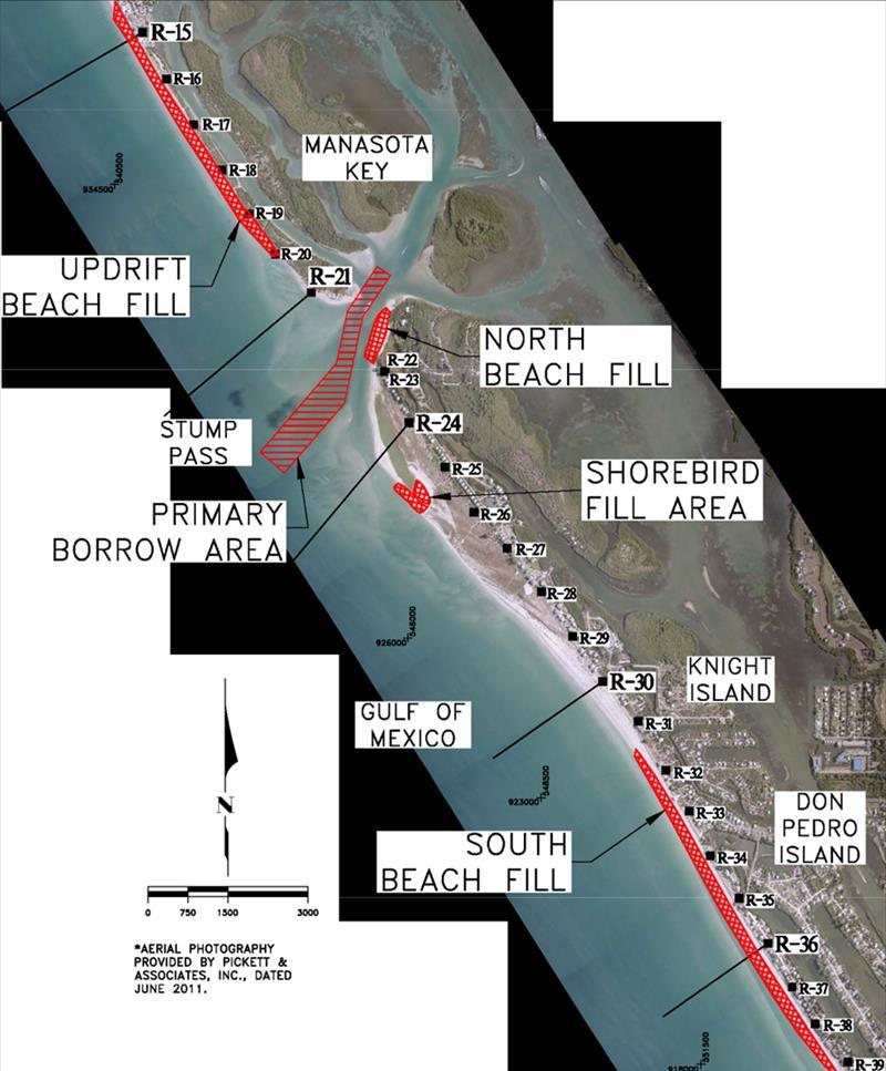
3 LOCATION MAP
4 OUTLINE Historical Perspective Plan Formulation Alternatives Development Numerical Model Study Alternatives Analysis Performance Evaluation Summary and Recommendations
5 HISTORICAL PERSPECTIVE By Late 1980's, Through 1990's, and Into Early 2000's Stump Pass and Adjacent Shorelines Experienced Significant Changes Channel Infilling Reduced Navigational Access, Spit Migration off Manasota Key Resulted in Significant Erosion on Palm Island (downdrift) Shoreline Breaching was Observed Both on State Park Beach as well as Gulf-front Beaches Downdrift of Stump Pass
6 EROSION CONTROL PROJECT HISTORY HISTORICAL PERSPECTIVE 2003: Initial Restoration Placed ~925,000 CY from Stump Pass and Nearshore Area Cut Through Spit Off Manasota Key to Restore 1980 Channel 2006: First Renourishment Placed ~426,000 CY from Stump Pass Modified Channel Alignment 2011: Second Renourishment Placed ~374,000 CY from Stump Pass Created Shorebird Habitat Area CURRENT: Develop New Long-Term Management Plan
7 PLAN FORMULATION Fill Renourishment and New Structural Complement Restore & Maintain Critically Eroding Beaches Provide Storm Damage Reduction Benefits Along Developed Shoreline Through Engineered Beach Design Provide for Improved Navigation Through Stump Pass Enhance Recreational Opportunities Provide Environmental Protection and Enhancement for T&E Species Apply Adaptive Management
8 STRUCTURAL DESKTOP SUMMARY PLAN FORMULATION Continue / Modify Beach Renourishment & Maintenance Dredging Terminal Groin (North of Inlet) Terminal Groins (North and South of Inlet) Groin Field (North and / or South of Inlet) Ebb Shoal Restoration Throat Armoring ~ Screened Out Seawalls / Revetment ~ Screened Out Breakwaters ~ Screened Out Innovative Technologies ~ Screened Out Interior Channel Dredging ~ Screened Out
9 STAKEHOLDER INPUT PLAN FORMULATION Residents of Palm Island Revisited Alternatives and Expressed That They Did Not Favor a Terminal Groin on North End of Palm Island (South Side of Inlet) Instead Preferring a T-groin Field if Alternatives Analysis Determined That a Structural Complement was Beneficial
10 ALTERNATIVES DEVELOPMENT Detailed Numerical Model Study Conceptual Plans Beach Fills Updrift (180,000 CY) North (40,000 CY) South (200,000 CY) Structural Complements Terminal Groin (MK) Permeable Groin Field (MK) T-groin Field (PI) Ebb Shoal Restoration

11 ALTERNATIVES DEVELOPMENT BEACH FILL AND TERMINAL STRUCTURE ALTERNATIVE 1


12 ALTERNATIVES DEVELOPMENT BEACH FILL AND PERMEABLE GROIN FIELD ALTERNATIVE 2

13 ALTERNATIVES DEVELOPMENT BEACH FILL AND T-GROIN FIELD ALTERNATIVE 3

14 ALTERNATIVES DEVELOPMENT EBB SHOAL RESTORATION ALTERNATIVE 4


15 NUMERICAL MODEL STUDY Delft3D Model Three-dimensional (3-D) State-of-the-art Fully-coupled Simulation of Waves, Flow, and Sediment Transport Open Source Model Calibration and Validation Gauge Deployment to Collect Data Topo/bathy Model Study Survey Topo/bathy Historic Monitoring Surveys
 0.1 0.43 Chezy Bottom Roughness 25 145 Stress Formulation due to Waves Fredsoe, Grant, Van Rijn Minimum Depth for Sediment Calculation (m) 0.")
16 MODEL CALIBRATION NUMERICAL MODEL STUDY July 30 September 4, Dimensional(4 Layers) Forty-seven (47) Simulations with Various Combinations of Model Parameters and Formulations Parameter Range Number of Vertical Layers 1, 4, 8, 10 Sediment Size (mm) Chezy Bottom Roughness Stress Formulation due to Waves Fredsoe, Grant, Van Rijn Minimum Depth for Sediment Calculation (m) Wave Related Transport Factor Current Related Transport Factor
17 Elevation (ft, NAVD88) Elevation (ft, NAVD88) Elevation (ft, NAVD88) Current Velocity (ft/s) Current Velocity (ft/s) Current Velocity (ft/s) NUMERICAL MODEL STUDY 2 1 MODEL CALIBRATION: July 30 Sept. 4, 2012 Water Elevation - Stump Pass Current Velocity - Stump Pass Modeled Measured Jul-30 Aug Aug-9 Modeled Measured Jul-30 Aug Aug Modeled Measured Aug-11 Aug Aug-21 Modeled Measured Aug-11 Aug Aug Modeled Measured Aug-23 Aug Sep-2 Modeled Measured Aug-23 Aug Sep-2
18 Wave Height (ft) Wave Height (ft) Wave Period (sec) Wave Period (sec) NUMERICAL MODEL STUDY MODEL CALIBRATION: July 30 Sept. 4, Wave Height - Offshore 15 Wave Period - Offshore 6 Modeled Measured Modeled Measured Julian Day (2012) Julian Day (2012) 7 Wave Height - Stump Pass 15 Wave Period - Stump Pass 6 Modeled Measured Modeled Measured Julian Day (2012) Julian Day (2012)


19 NUMERICAL MODEL STUDY MODEL CALIBRATION: July 30 Sept. 4, 2012 Measured Morphologic Changes Modeled Morphologic Changes
20 Shoreline Changes Volumetric Changes NUMERICAL MODEL STUDY MODEL CALIBRATION: July 30 Sept. 4, 2012 Cell # Measured Shoreline Modeled Shoreline Change Change at MHW (ft) at MHW (ft) 1: R-8 R : R-14 R : R-20 Stump Pass : Stump Pass Not Applicable Not Applicable 5: Stump Pass R : R-26 R : R-29 R : R-39 R Cell # Measured Volume Change Modeled Volume Change to DOC (cy) to DOC (cy) 1: R-8 R-14 2,120 2,777 2: R-14 R-20-3,360-2,275 3: R-20 Stump Pass -2,837-2,140 4: Stump Pass 9,861 2,097 5: Stump Pass R : R-26 R-29 14,769 9,503 7: R-29 R-39-15,040-3,902 8: R-39 R-47-7,534-5,108


21 NUMERICAL MODEL STUDY MODEL VALIDATION: JULY 31, 2008 AUG. 1, 2009 Measured Morphologic Changes Modeled Morphologic Changes
22 Shoreline Changes Volumetric Changes NUMERICAL MODEL STUDY MODEL VALIDATION: JULY 31, 2008 AUG. 1, 2009 Cell # Measured Shoreline Modeled Shoreline Change at MHW (ft) Change at MHW (ft) 1: R-8 R : R-14 R : R-20 Stump Pass : Stump Pass Not Applicable Not Applicable 5: Stump Pass R : R-26 R : R-29 R : R-39 R Cell # Measured Volume Modeled Volume Change Change to DOC (cy) to DOC (cy) 1: R-8 R-14 38,979 22,110 2: R-14 R-20-78, ,195 3: R-20 Stump Pass -5,369-23,702 4: Stump Pass 54,710 79,229 5: Stump Pass R26-75, ,066 6: R-26 R-29-18,014-47,883 7: R-29 R-39 78,283 39,472 8: R-39 R-47 3, ,969
23 ALTERNATIVES ANALYSIS R-17 ALTERNATIVE ALTERNATIVE 1 R R-20 MANASOTA KEY R-21 UBF Toe NBF Landward Limit Terminal Groin STUMP PASS T-Groins STUMP PASS PALM ISLAND PALM ISLAND R-23 R r020 R-22 r R R R-21 UBF Toe 200' Permeable Groin 400' Permeable Groin NBF Landward Limit STUMP PASS r020 PALM ISLAND R r021 r Easting (ft) R-21 STUMP PASS NBF Toe Ebb Shoal Restoration Area NBF Landward Limit R-22 PALM ISLAND R-23 R r MANASOTA KEY NBF Crest R R-20 NBF Crest R UBF Crest UBF Landward Limit UBF Toe R-22 NBF Toe R-24 r022 r022 MANASOTA KEY R R Northing (ft) UBF Landward Limit 300' Permeable Groin ALTERNATIVE 4 R-18 Elevation (ft, NAVD88) Elevation (ft, NAVD88) R ALTERNATIVE 2 R-18 UBF Crest Easting (ft) Easting (ft) NBF Crest NBF Toe R-23 R Northing (ft) NBF Landward Limit NBF Crest R-22 NBF Toe Terminal Groin Northing (ft) r022 UBF Crest MANASOTA KEY UBF Landward Limit Elevation (ft, NAVD88) R Northing (ft) Elevation (ft, NAVD88) R Easting (ft) R

24 ALTERNATIVES ANALYSIS MODEL RESULTS: 4-YEAR SIMULATION No New Action Terminal Groin on Manasota Key
25 PERFORMANCE EVALUATION Acreage Change Volumetric Change Borrow Area Infilling Downdrift Effects Controlling Depth Construction Budget
26 ALTERNATIVE ACREAGE CHANGE SCORING SUMMARY VOLUME CHANGE BORROW AREA INFILLING DOWNDRIFT EFFECTS* CONTROLLING DEPTH CONSTRUCTION BUDGET TOTAL SCORE PERFORMANCE EVALUATION RANK UBF NBF SBF UBF NBF SBF # # # # #3 0: No New Action 1: Terminal groin on Manasota Key (MK) 2: Permeable groin field on MK 3: Term. groin on MK & T-groin field on Palm Island 4: Ebb Shoal Restoration * Higher Score = Better Performance
27 DISCUSSION Perm. Groin Field on MK Identified as Preferred Term. Groin Identified as Viable Option Beach Renourishment Remains Critical and is Recommended on an 8-year Cycle Inlet Channel Maintenance Dredging is Recommended on a 4-year Cycle T-groin Field is Recommended as an Adaptive Management Strategy Ebb Shoal Restoration is Also Recommended as an Adaptive Management Strategy
28 FDEP AND PARK SERVICE INPUT DISCUSSION Florida Park Service Concluded That the Term. Groin was Considered Favorable Concerns of Downdrift Impacts Immediately South of Proposed Terminal Groin (within State Park Beach) were expressed by Florida Park Service Additional modeling was suggested
29 ADDITIONAL MODELING TERMINAL GROIN OPTIONS Alt 1A: Terminal Groin is 200 Feet Longer Alt 1B: Terminal Groin is Shifted South 250 Feet Alt 1C: Terminal Groin is Shifted South 500 Feet Alt 1D: Terminal Groin s Orientation is Shifted 45 Alt 1E: Terminal Groin is 20% Permeable Alt 1F: Terminal Groin is 40% Permeable Alt 1G: Terminal Groin Crest is 1.5 Feet Lower


30 ADDITIONAL MODELING MODEL RESULTS: 4-YEAR SIMULATION Alt 1A vs. Alt 1 Alt 1F vs. Alt 1
31 ALTERNATIVE ACREAGE CHANGE SCORING SUMMARY VOLUME CHANGE DOWNDRIFT BORROW AREA INFILLING CONSTRUCTION BUDGET EFFECTS * TOTAL SCORE RANK UBF UBF NBF MK PI #6 1A #1 1B #7 1C #5 1D #8 1E #3 1F #4 1G #2 1A: Terminal Groin is 200 Feet Longer 1B: Terminal Groin is Shifted South 250 Feet 1C: Terminal Groin is Shifted South 500 Feet 1D: Terminal Groin s Orientation is Shifted 45 1E: Terminal Groin is 20% Permeable 1F: Terminal Groin is 40% Permeable 1G: Terminal Groin Crest is 1.5 Feet Lower * Higher Score = Better Performance MK = Manasota Key PI = Palm Island ADDITIONAL MODELING
32 RECOMMENDATIONS Screen Out Alternatives 1A, 1B, 1C, and 1D due to Potential Downdrift Impacts (and Higher Costs) Alternatives 1E and 1F (Increased Permeability) as well as Alternative 1G (Lower Crest Elevation) are Recommended for Consideration Seeking Input from FDEP and Florida Park Service to Select Permeability and Crest Elevation of Proposed Structure Submit JCP for Anticipated 2015 Construction
33 ACKNOWLEDGEMENTS Charlotte County BCC & Staff Advisory Committees Residents & Boating Community FDEP Beaches FL State Park Staff FFWCC & Aquatic Preserves Federal Agencies Shorebird and Sea Turtle Monitors Coastal Tech & Coastal Engineering
DESIGN ENGINEERING ANALYSIS FOR TERMINAL GROIN LENGTH
 APPENDIX F DESIGN ENGINEERING ANALYSIS FOR TERMINAL GROIN LENGTH (Prepared by Olsen Associates, Inc.) DRAFT Environmental Impact Statement Village of Bald Head Island Shoreline Protection Project Brunswick
Alexandra Carvalho, Ph.D., GISP Kathy Fitzpatrick, P.E.
 Coastal Data Organization for Project Management and Coastal Planning Martin County, Florida Alexandra Carvalho, Ph.D., GISP Kathy Fitzpatrick, P.E. Outline County Coastal Programs Coastal Geodatabase
Mark H. Horwitz Ping Wang PhD Coastal Research Laboratory, School of Geosciences University of South Florida
 Mark H. Horwitz Ping Wang PhD Coastal Research Laboratory, School of Geosciences University of South Florida American Shore & Beach Preservation Association 2015 National Coastal Conference, New Orleans,
The Impact of Hurricane Irma on the Coast of Florida
 The Impact of Hurricane Irma on the Coast of Florida Ralph Clark, Guy Weeks, Robert Wang, Mike Manausa & Peter Bacopoulos Division of Water Resource Management February 8, 2018 Overview: Hurricane Irma
ENGINEERING APPROACHES TO SHORELINE PLACEMENT FROM COAST TO COAST
 ENGINEERING APPROACHES TO SHORELINE PLACEMENT FROM COAST TO COAST 237 237 237 217 217 217 200 200 200 0 0 0 163 163 163 131 132 122 80 119 27 252 174.59 83 36 118 110 135 120 112 92 56 62 102 130 Comparing
Regional Sediment Management
 Regional Sediment Management Linda S. Lillycrop Program Manager Coastal Engineer US Army Engineer Research and Development Center Coastal and Hydraulics Laboratory Q AVG Coastal Resilience: The Environmental,
EAST PASS UP-DATE SUMMARY OF FINDINGS REPORT and INLET MANAGEMENT IMPLEMENTATION PLAN
 EAST PASS 2013 UP-DATE SUMMARY OF FINDINGS REPORT and INLET MANAGEMENT IMPLEMENTATION PLAN Introduction On June 8, 2000, the Florida Department of Environmental Protection adopted the East Pass Inlet Management
DESIGN ENGINEERING ANALYSIS FOR TERMINAL GROIN LENGTH
 APPENDIX I DESIGN ENGINEERING ANALYSIS FOR TERMINAL GROIN LENGTH (Prepared by Olsen Associates, Inc.) Final Environmental Impact Statement Village of Bald Head Island Shoreline Protection Project Brunswick
MISSISSIPPI COASTAL IMPROVEMENTS
 MISSISSIPPI COASTAL IMPROVEMENTS PROGRAM (MsCIP) Comprehensive Barrier 237 27 200 237 27 200 Island 237 Restoration 27 200 Plan 80 9 27 252 74.59 255 255 255 0 0 0 63 63 63 3 32 22 239 65 53 0 35 20 2
SEGMENTED BREAKWATERS AND THEIR USE IN COASTAL LOUISIANA
 SEGMENTED BREAKWATERS AND THEIR USE IN COASTAL LOUISIANA Prepared by: Louisiana Coastal Protection and Restoration Authority Engineering Division March 2016 The geology of Louisiana s coastal zone is intimately
Morphological Modeling of Inlets and Adjacent Shorelines on Engineering Timescales
 CB&I Morphological Modeling of Inlets and Adjacent Shorelines on Engineering Timescales Challenges and Model Improvements based on Recent Studies Dobrochinski, J.P.H.; Benedet, L.; Signorin, M.; Pierro,
DIVISION OF COASTAL MANAGEMENT TO STUDY CURRENT LONG-TERM EROSION RATES ADJACENT TO TERMINAL GROINS
 DIVISION OF COASTAL MANAGEMENT TO STUDY CURRENT LONG-TERM EROSION RATES ADJACENT TO TERMINAL GROINS North Carolina Department of Environmental Quality Division of Coastal Management February 22, 2018 N.
Nearshore Placement as a Regional Sediment Management Practice
 Nearshore Placement as a Regional Sediment Management Practice Katherine E. Brutsché, Ph.D. Brian C. McFall, Ph.D., P.E. Coastal and Hydraulics Laboratory US Army Engineer R&D Center ASBPA National Coastal
ENGINEERING WITH NATURE: NEARSHORE BERM PLACEMENTS AT FORT MYERS BEACH AND PERDIDO KEY, FLORIDA, USA
 1 ENGINEERING WITH NATURE: NEARSHORE BERM PLACEMENTS AT FORT MYERS BEACH AND PERDIDO KEY, FLORIDA, USA KATHERINE E. BRUTSCHÉ 1, PING WANG 2, JULIE D. ROSATI 1, CHERYL E. POLLOCK 1 1. U.S. Army Engineer
COASTAL SEDIMENT BUDGET FOR JUPITER INLET, FLORIDA
 COASTAL SEDIMENT BUDGET FOR JUPITER INLET, FLORIDA By KRISTEN MARIE ODRONIEC A THESIS PRESENTED TO THE GRADUATE SCHOOL OF THE UNIVERSITY OF FLORIDA IN PARTIAL FULFILLMENT OF THE REQUIREMENTS FOR THE DEGREE
INFLUENCE OF INLET / SHOAL COMPLEX ON ADJACENT SHORELINES VIA INLET SINK METHOD
 INFLUENCE OF INLET / SHOAL COMPLEX ON ADJACENT SHORELINES VIA INLET SINK METHOD Kelly R. Legault, Ph.D., P.E. 1, Tanya M. Beck 2 and Jason A. Engle, P.E. 3 The region of influence of the inlet on the adjacent
A SEDIMENT BUDGET ANALYSIS AND MANAGEMENT STRATEGY FOR FORT PIERCE INLET, FL
 A SEDIMENT BUDGET ANALYSIS AND MANAGEMENT STRATEGY FOR FORT PIERCE INLET, FL By Elba Rodriguez and Robert G. Dean Department of Civil and Coastal Engineering University of Florida Gainesville, FL 32611,
SHORELINE AND BEACH PROCESSES: PART 2. Implications for Coastal Engineering
 SHORELINE AND BEACH PROCESSES: PART 2 Implications for Coastal Engineering Objectives of the lecture: Part 2 Show examples of coastal engineering Discuss the practical difficulties of ocean engineering
Material Workshop. Galveston District 2012 Beneficial Use of Dredged. Material Workshop. Custodians of the Coast
 Galveston District 2012 Beneficial Use of Dredged Material Workshop Galveston District 2012 Beneficial Use of Dredged Material Workshop US Army Corps of Engineers BUILDING STRONG Welcome Opening Remarks
Regional Sediment Management at East Rockaway Inlet, NY, Utilizing the USACE Coastal Modeling System
 Regional Sediment Management at East Rockaway Inlet, NY, Utilizing the USACE Coastal Modeling System by US Army Engineer District, New York PURPOSE: This Coastal and Hydraulics Engineering Technical Note
ST. JOHNS COUNTY, FLORIDA South Ponte Vedra Beach, Vilano Beach, and Summer Haven Reaches
 ST. JOHNS COUNTY, FLORIDA South Ponte Vedra Beach, Vilano Beach, and Summer Haven Reaches COASTAL STORM RISK MANAGEMENT PROJECT DRAFT INTEGRATED FEASIBILITY STUDY AND ENVIRONMENTAL ASSESSMENT APPENDIX
Coastal Inlets Research Program US Army Corps of Engineers Engineering Research and Development Center
 Coastal Inlets Research Program US Army Corps of Engineers Engineering Research and Development Center Site of Moriches Inlet Nov. 1951 Julie Dean Rosati and Nicholas C. Kraus, CIRP Program Manager Shinnecock
South Carolina BMA. Jurisdictional Line Revisions
 South Carolina BMA Jurisdictional Line Revisions 40 Year Retreat Policy A forty year policy of retreat from the shoreline is established. The department must implement this policy and utilize the best
Randall W. Parkinson, Ph.D., P.G. Institute of Water and Environment Florida International University
 An Update on Adaptation Action Activities Undertaken Since Completion of the City of Satellite Beach (FL) Vulnerability Assessment to Rising Seas (2010) Randall W. Parkinson, Ph.D., P.G. Institute of Water
Connecticut Coastal Management Program
 Connecticut Coastal Management Program Fact Sheet for SHORELINE FLOOD AND EROSION CONTROL STRUCTURES What are Shoreline Flood and Erosion Control Structures? The Connecticut General Statutes (CGS) define
Engineering with Nature: Nearshore Berm Placements at Fort Myers Beach and Perdido Key, Florida, USA
 Engineering with Nature: Nearshore Berm Placements at Fort Myers Beach and Perdido Key, Florida, USA Katherine E. Brutsché, Ph.D. Research Physical Scientist ERDC-Coastal & Hydraulics Laboratory May 14,
Whiskey Island Marsh Creation Rolling with the Punches
 Whiskey Island Marsh Creation Rolling with the Punches Santiago Alfageme, M&N Jerry Carroll, LADNR Brad Miller, LADNR Project Location Historic Island Retreat Previous Restoration Project Whiskey Island
RESULTS FROM THE TEXAS COASTAL SEDIMENT SOURCES: A GENERAL EVALUATION STUDY
 RESULTS FROM THE TEXAS COASTAL SEDIMENT SOURCES: A GENERAL EVALUATION STUDY JUAN MOYA KELSEY CALVEZ CRIS WEBER ANTHONY RISKO *KEVIN FRENZEL FREESE AND NICHOLS, INC. COASTAL AND WATERWAYS GROUP OBJECTIVES
Regional Sediment Management: The Long Island Coastal Planning Project
 Regional Sediment Management: The Long Island Coastal Planning Project Lynn M. Bocamazo Senior Coastal Engineer USACE-New York District 22 September 2009 US Army Corps of Engineers Outline Project Location
Geology Setting Management Options Management Structure
 Geology Setting Management Options Management Structure WFF = Wallops Flight Facility LST = Longshore sediment transport SLR = Sea level rise September 29, 2015 Accomack County/Accomack Northampton County
Heather Schlosser Army Corps of Engineers Coastal Studies Group August 28, 2008
 Got sand? Regional Sediment Management in Orange County Heather Schlosser Army Corps of Engineers Coastal Studies Group August 28, 2008 Regional Sediment Management Regional sediment management recognizes
GenCade. Combining and Extending the GENESIS and Cascade Models for Planning and Design in a Regional Sediment Management Framework
 GenCade Combining and Extending the GENESIS and Cascade Models for Planning and Design in a Regional Sediment Management Framework G Presented by Nicholas C. Kraus For the GenCade Development Team Ken
MARTIN COUNTY BOARD OF COUNTY COMMISSIONERS
 MARTIN COUNTY BOARD OF COUNTY COMMISSIONERS 4 S.E. MONTEREY ROAD STUART, FL 34996 DOUG SMITH Commissioner, District ED FIELDING Commissioner, District ANNE SCOTT Commissioner, District 3 SARAH HEARD Commissioner,
The Sediment Budget Calculator: A Webtool to Develop a Family of Viable Inlet and Adjacent Beach Sediment Budget Solutions
 The Sediment Budget Calculator: A Webtool to Develop a Family of Viable Inlet and Adjacent Beach Sediment Budget Solutions by Julie Dean Rosati, Charles A. Sumner, and Derek A. Wilson PURPOSE: This Coastal
PRESENTATION TITLE. Regional Sediment Management Application of a Coastal Model at the St. Johns River Entrance BUILDING STRONG
 PRESENTATION TITLE Regional Sediment Management Application of a Coastal Model at the St. Johns River Entrance Steven Bratos Senior Coastal Engineer U.S. Army Corps of Engineers Jacksonville District February
memorandum Preliminary Implementation Options Overview Coastal Armor by Reach San Francisco Littoral Cell CRSMP Stakeholder Advisory Group
 550 Kearny Street Suite 900 San Francisco, CA 94108 415.262.2300 phone 415.262.2303 fax www.pwa-ltd.com memorandum date June 5, 2012 to from subject San Francisco Littoral Cell CRSMP Stakeholder Advisory
Annual transport rates at two locations on the fore-slope.
 Sediment Transport by Currents Fore-slope Sediment transport rates and sediment concentrations were computed from the hydrodynamic model runs as well as from direct measurements of current velocities at
GALVESTON BAY RSM Moving toward an Integrated, Cooperative, and Holistic Approach to Estuarine Sediments
 GALVESTON BAY RSM Moving toward an Integrated, Cooperative, and Holistic Approach to Estuarine Sediments RAE Conference 2010 Larry A. Wise Moffatt & Nichol RSM is a system-based approach for collaboratively
Holderness Erosion and Evolution of the Spurn Peninsula
 Holderness Erosion and Evolution of the Spurn Peninsula Prof. Ken Pye and Dr. Simon Blott Kenneth Pye Associates Ltd. Outline of the Presentation Overview of historical erosion trends Effects of coast
SBEACH High-Frequency Storm Erosion Model Study for Sarasota County. Final Report
 SBEACH High-Frequency Storm Erosion Model Study for Sarasota County Final Report by S. Y. Wang and M. Manausa Sponsored by Florida Department of Environmental Protection, Bureau of Beaches and Coastal
Coastal and Hydraulics Laboratory
 ERDC/CHL TR-12-14 Coastal Inlets Research Program Optimization of Ebb Shoal Mining and Beach Nourishment at St. Johns County, St. Augustine Inlet, Florida Report 3 Tanya M. Beck and Kelly Legault August
Planning for the Future of Humboldt Bay: Sea Level Rise, Sediment Management, Sand Spits and Salt Marshes. Joel Gerwein
 Planning for the Future of Humboldt Bay: Sea Level Rise, Sediment Management, Sand Spits and Salt Marshes Joel Gerwein Introduction to Humboldt Bay Setting Economy, community, and environment Sediment
Palm Beach County, Florida Jupiter-Carlin Segment Section 934 Report. Appendix A Engineering Appendix
 Palm Beach County, Florida Jupiter-Carlin Segment Section 934 Report Appendix A Engineering Appendix Table of Contents 1 Background... 1 2 Purpose... 1 3 Natural Forces... 2 3.1 Winds... 2 3.2 Waves...
Del Mar Sediment Management Study
 Del Mar Sediment Management Study Shoreline Preservation Working Group, June 7, 2018 Lindsey Sheehan Current work in Del Mar 2016 Sea-Level Rise Vulnerability Assessment 2018 Adaptation Plan 2018 Sediment
Project (Project No. US-CA-62-2) Maintenance Inspection and Reports (Subtask 14.1) Inspection Report No.2
 Maintenance Inspection and Reports (Subtask 14.1) Inspection Report No.2") MEMORANDUM TO: FROM: Jim Well, Ducks Unlimited Mike Harvey, PhD, PG SUBJECT: M&T/ Llano Seco Fish Screen Project (Project No. US-CA-62-2) Maintenance Inspection and Reports (Subtask 14.1) Inspection Report
MEMORANDUM TO: FROM: Jim Well, Ducks Unlimited Mike Harvey, PhD, PG SUBJECT: M&T/ Llano Seco Fish Screen Project (Project No. US-CA-62-2) Maintenance Inspection and Reports (Subtask 14.1) Inspection Report
ΛTKINS. Applications of Regional Sediment Management Concepts in Texas Estuarine Restoration Projects. Riparian Workshop Fort Worth, October 17, 2012
 Juan C Moya, PhD., PG Coastal Planning and Restoration Applications of Regional Sediment Management Concepts in Texas Estuarine Restoration Projects Riparian Workshop Fort Worth, October 17, 2012 West
Coastal Processes and Shoreline Erosion on the Oregon Coast, Cascade Head to Cape Kiwanda
 State of Oregon Department of Geology and Mineral Industries Vicki S. McConnell, State Geologist Open File Report OFR O-04-11 Coastal Processes and Shoreline Erosion on the Oregon Coast, Cascade Head to
Presentation Outline. Project Overview. Sea Level Rise Assessment & Decision Tools. Community Engagement. Tina Whitman, Friends of the San Juans
 Healthy Beaches for People & Fish Sea Level Rise Adaptation Tools for San Juan County, WA Tina Whitman & Andrea MacLennan December 10, 2015 Presentation Outline Project Overview Tina Whitman, Friends of
Coastal Barrier Island Network (CBIN): Management strategies for the future
: Management strategies for the future") Coastal Barrier Island Network (CBIN): Management strategies for the future Heather Joesting*, Amy Williams**, Rusty Feagin**, and William K. Smith* *Department of Biology, Wake Forest University, Winston
Coastal Barrier Island Network (CBIN): Management strategies for the future Heather Joesting*, Amy Williams**, Rusty Feagin**, and William K. Smith* *Department of Biology, Wake Forest University, Winston
CHAPTER 212 THE EXTENT OF INLET IMPACTS UPON ADJACENT SHORELINES. Kevin R. Bodge, Ph.D., Member ASCE 1
 CHAPTER 212 THE EXTENT OF INLET IMPACTS UPON ADJACENT SHORELINES Kevin R. Bodge, Ph.D., Member ASCE 1 Abstract The erosional impacts of improved inlets upon adjacent shorelines may be best estimated by
ARE WE PROTECTING THE BENEFICIAL FUNCTIONS OF COASTAL LANDFORMS? AN ANALYSIS OF ACTIVITIES PERMITTED ON COASTAL LANDFORMS ON CAPE COD IN 1999
 ARE WE PROTECTING THE BENEFICIAL FUNCTIONS OF COASTAL LANDFORMS? AN ANALYSIS OF ACTIVITIES PERMITTED ON COASTAL LANDFORMS ON CAPE COD IN 1999 James F. O Connell, WHOI Sea Grant & Cape Cod Cooperative Extension
APPENDIX C INLET MANAGEMENT PLAN
 APPENDIX C INLET MANAGEMENT PLAN DRAFT INLET MANAGEMENT PLAN LOCKWOODS FOLLY INLET, NC 1.0 INTRODUCTION The Town of Holden Beach (herein referred to as the Town ) has proposed the construction of a terminal
Numerical models in context of coastal climate change, adaptation and protection schemes. Nils Drønen Head of Innovation, CED, DHI
 Numerical models in context of coastal climate change, adaptation and protection schemes Nils Drønen Head of Innovation, CED, DHI Agenda Introduction How can we quantify coastal response to climate change
Environment Bay of Plenty Ohope Beach system
 Environment Bay of Plenty 7 5. Ohope Beach system Environmental Publication 27/ NERMN Beach Profile Monitoring Environment Bay of Plenty 5..1 Ohope Spit (CCS 9) Discussion The site is located 2m to the
Adapting to Rising Sea Level & Extreme Weather Events:
 Adapting to Rising Sea Level g & Extreme Weather Events: A Florida Perspective Randall W. Parkinson, Ph.D., P.G. President RWParkinson Consulting, Inc. Melbourne, Florida & Administrator Space Coast Climate
Assessing Sea Level Rise, Storm Surge and Flooding Risks at the Ogunquit Wastewater Treatment Facility COMMITMENT & INTEGRITY DRIVE RESULTS
 Assessing Sea Level Rise, Storm Surge and Flooding Risks at the Ogunquit Wastewater Treatment Facility September 27, 2012 Presentation Outline Reasons for the Study Sea Level Rise, Storm Surge & Flooding
ERDC Update SAD Regional Management Board
 ERDC Update SAD Regional Management Board José E. Sanchez, P.E., SES Director, Coastal and Hydraulics Laboratory Engineer Research and Development Center 14FEB17 Overview of R&D Activities in AOR Cross
HAWAII REGIONAL SEDIMENT MANAGEMENT
 HAWAII REGIONAL SEDIMENT MANAGEMENT KAUAI Workshop January 20, 2011 Kauai Veteran s Center Kihei, HI of Engineers, Honolulu District AGENDA 1300-1310 Welcome and Introductions Conger Conant 1310-1330 Regional
Donald K. Stauble and Bill Birkemeier Coastal and Hydraulics Laboratory US Army Corps of Engineers
 Donald K. Stauble and Bill Birkemeier Coastal and Hydraulics Laboratory US Army Corps of Engineers Define the Problem Navigation Shore Protection Environmental Political So what is the problem? Management
Sea-level Rise on Cape Cod: How Vulnerable Are We? Rob Thieler U.S. Geological Survey Woods Hole, MA
 Sea-level Rise on Cape Cod: How Vulnerable Are We? Rob Thieler U.S. Geological Survey Woods Hole, MA Outline Sea-level and coastal processes Past sea-level change Predictions for the future Coastal responses
How to Read These Flood Hazard Maps
 How to Read These Flood Hazard Maps The United States Geological Survey (USGS) has developed the Coastal Storms Modeling System (CoSMoS), which projects coastal flooding and erosion from coastal storms,
SEDIMENT BUDGET: MISSISSIPPI SOUND BARRIER ISLANDS*
 2366 SEDIMENT BUDGET: MISSISSIPPI SOUND BARRIER ISLANDS* MARK R. BYRNES 1, JULIE D. ROSATI 2, SARAH F. GRIFFEE 1 1. Applied Coastal Research and Engineering, Inc., 766 Falmouth Road, Suite A-1, Mashpee,
Evaluation of Storm Tide Measurements at Panama City Beach, FL
 Evaluation of Storm Tide Measurements at Panama City Beach, FL 1993-2007 Prepared by Mark E. Leadon Beaches and Shores Resource Center Florida State University May 2009 Prepared for Florida Department
Coastal Processes 101. Greg Berman (Woods Hole Sea Grant & Cape Cod Cooperative Extension)
") Coastal Processes 101 Greg Berman (Woods Hole Sea Grant & Cape Cod Cooperative Extension) January 23, 2019 Coastal Processes 101 Outline: ~30 min talk Coastal Processes What is Erosion? Value of the Ecosystem
Coastal Processes 101 Greg Berman (Woods Hole Sea Grant & Cape Cod Cooperative Extension) January 23, 2019 Coastal Processes 101 Outline: ~30 min talk Coastal Processes What is Erosion? Value of the Ecosystem
Coastal Flood Risk Study Project for East Coast Central Florida Study Area
 Coastal Flood Risk Study Project for East Coast Central Florida Study Area St Lucie County, Florida Flood Risk Review Meeting March 28, 2017 Introductions Risk MAP Project Team FEMA Region IV BakerAECOM,
FILL SUITABILITY CHARACTERIZATION OF A COMPLEX COASTAL AREA: DARE COUNTY, NORTH CAROLINA
 FILL SUITABILITY CHARACTERIZATION OF A COMPLEX COASTAL AREA: DARE COUNTY, NORTH CAROLINA Donald K. Stauble 1, William Birkemeier, Michael F. Forte and William A. Dennis 3 ABSTRACT As part of the design
Coastal Sediment Properties and Longshore Sediment Transport
 Coastal Sediment Properties and Longshore Sediment Transport Julie Rosati Julie.D.Rosati@erdc.usace.army.mil 601-634-3005 Coastal Planning Course Lesson #8 Tuesday 8:00-9:00 am CEM III-1, III-2 1. Coastal
SBEACH High-Frequency Storm Erosion Model Study for Palm Beach County. Final Report
 SBEACH High-Frequency Storm Erosion Model Study for Palm Beach County Final Report by S. Y. Wang and M. Manausa Sponsored by Florida Department of Environmental Protection, Bureau of Beaches and Coastal
Linking Inlet Hydrodynamics and Morphologic Response at Oregon Inlet, NC
 Linking Inlet Hydrodynamics and Morphologic Response at Oregon Inlet, NC Prepared for: Sharon Ahlers Engineering Communications Program Cornell University Prepared by: Justin Vandever School of Civil and
Webinar on PTM with CMS
 Webinar on PTM with CMS Honghai Li Research Physical Scientist Mitchell E. Brown Civil Engineering Technician Engineer Research and Development Center CMS December 4, 2013 US Army Corps of Engineers BUILDING
Pinellas, Manatee, and Sarasota Counties, Florida; Regional Sediment Budget
 Pinellas, Manatee, and Sarasota Counties, Florida; Regional Sediment Budget by Kelly R. Legault and Ashley E. Frey PURPOSE: This U.S. Army Corps of Engineers (USACE) Regional Sediment Management Technical
Quantifying effects of oil on coastal dune vegetation. Thomas Miller and Elise Gornish Biological Science, Florida State University
 Quantifying effects of oil on coastal dune vegetation Thomas Miller and Elise Gornish Biological Science, Florida State University Natural History of Barrier Islands in the Northern Gulf Make up ~70% of
Application #: TEXT
 TOWN OF FORT MYERS BEACH 2008 PROPOSED COMPREHENSIVE PLAN AMENDMENTS Application #: 2008-13-TEXT Description: Modify the Coastal Management and Future Land Use Elements to reflect the state s new definition
Design of Levee Breaches in Sheltered Water for Flood Risk Reduction & Marsh Restoration ASFMP; June 5, 2014 Presented By:
 Design of Levee Breaches in Sheltered Water for Flood Risk Reduction & Marsh Restoration ASFMP; June 5, 2014 Presented By: Rohin Saleh Alameda County Flood Control District Matt Powers, P.E. GEI Consultants
Sediment Management in the Coastal Bays
 Sediment Management in the Coastal Bays Introduction Need for ecosystem view of sediment management in Coastal Bays Island loss and restoration Navigation needs Habitat Trade offs Living Shoreline Requirements
STORM IMPACT MODELING ANALYSIS FOR THE RESTORATION OF GULF STATE PARK, AL
 STORM IMPACT MODELING ANALYSIS FOR THE RESTORATION OF GULF STATE PARK, AL Jordon Cheifet, PE, CFM Joao Dobrochinski, MSc Morjana Signorin APTIM Senior Project Engineer APTIM Numerical Modeling Lead APTIM
Seagrass Transplantation & Environmental & Marine Consulting Services, Inc. Drew Campbell, Vice President & Lead Scientst.
 Indian River Lagoon Symposium Seagrass Transplantation & Project Considerations Environmental & Marine Consulting Services, Inc. Drew Campbell, Vice President & Lead Scientst March 26 th, 2013 Regulatory
The U.S. Army Corps of Engineers Philadelphia District
 The U.S. Army Corps of Engineers Philadelphia District The Atlantic Coast of New Jersey Regional Sediment Budget 1986-2003 Cape May Point to Manasquan Inlet Final Report March 2006 The Atlantic Coast of
CHAPTER 135 COASTAL ARMORING: EFFECTS, PRINCIPLES AND MITIGATION. R. G. Dean*
 CHAPTER 135 COASTAL ARMORING: EFFECTS, PRINCIPLES AND MITIGATION by R. G. Dean* ABSTRACT An attempt is made to conduct a rational assessment of the potential adverse effects of coastal armoring on adjacent
KEYWORDS: erosion shoreline change nourishment community issues
 UNC Coastal Studies Institute 1 TITLE: Sand, Soil, Sediment Selection for Beach Nourishment KEYWORDS: erosion shoreline change nourishment community issues ABSTRACT: North Carolina s barrier islands are
EAGLES NEST AND PIASA ISLANDS
 EAGLES NEST AND PIASA ISLANDS HABITAT REHABILITATION AND ENHANCEMENT PROJECT MADISON AND JERSEY COUNTIES, ILLINOIS ENVIRONMENTAL MANAGEMENT PROGRAM ST. LOUIS DISTRICT FACT SHEET I. LOCATION The proposed
Mapping of Future Coastal Hazards. for Southern California. January 7th, David Revell, Ph.D. E.
 Mapping of Future Coastal Hazards for Southern California January 7th, 2014 David Revell, Ph.D. drevell@esassoc.com E. Vandebroek, 2012 Outline Coastal erosion hazard zones Flood hazard zones: Coastal
Coastal Erosion Risks - Beaches. Objectives
 Coastal Erosion Risks - Beaches Risk Management in Civil Engineering, Advanced Course Lisbon, November 21 st, 2008 Objectives To briefly introduce coastal processes governing sediment transport and beach
REGIONAL SEDIMENT MANAGEMENT IN THE CORPS OF ENGINEERS
 REGIONAL SEDIMENT MANAGEMENT IN THE CORPS OF ENGINEERS Julie D. Rosati 1, Lynn M. Bocamazo 2, Bruce D. Carlson 3, Jack E. Davis 1, Thomas D. Smith 4, Jennifer M. Wozencraft 5, Lynn Hardegree 5 ABSTRACT
West Galveston Bay Regional Sediment Management Plan (An Eco-geomorphologic Approach)
") West Galveston Bay Regional Sediment Management Plan (An Eco-geomorphologic Approach) Juan Moya, Matthew Mahoney and Mike Smith Restore America s Estuaries Conference Tampa, FL, October 23, 2012 Atkins
West Galveston Bay Regional Sediment Management Plan (An Eco-geomorphologic Approach) Juan Moya, Matthew Mahoney and Mike Smith Restore America s Estuaries Conference Tampa, FL, October 23, 2012 Atkins
Appendix I. Dredged Volume Estimates. Draft Contractor Document: Subject to Continuing Agency Review
 Appendix I Dredged Volume Estimates Draft Contractor Document: Subject to Continuing Agency Review Interoffice Correspondence Date: April 6, 2007 To: L. Bossi (WHI) Copy: S. Thompson (WHI), B. Fidler (NNJ)
COASTAL DATA APPLICATION
 2015 Coastal GeoTools Proactive By Design. Our Company Commitment COASTAL DATA APPLICATION Projecting Future Coastal Flood Risk for Massachusetts Bay Bin Wang, Tianyi Liu, Daniel Stapleton & Michael Mobile
Racing against time, an unprecedented year: the US Army Corps of Engineers (USACE) response to the hurricanes of 2004
 response to the hurricanes of 2004") Environmental Problems in Coastal Regions VI 205 Racing against time, an unprecedented year: the US Army Corps of Engineers (USACE) response to the hurricanes of 2004 R. I. McMillen 1, D. R. Haubner 2,
Environmental Problems in Coastal Regions VI 205 Racing against time, an unprecedented year: the US Army Corps of Engineers (USACE) response to the hurricanes of 2004 R. I. McMillen 1, D. R. Haubner 2,
Ed Curtis, PE, CFM, FEMA Region IX and Darryl Hatheway, CFM, AECOM ASFPM 2016, Grand Rapids, MI
 Methodology to Determine Process-Based Total Water Level Profiles in Areas Dominated by Wave Runup Ed Curtis, PE, CFM, FEMA Region IX and Darryl Hatheway, CFM, AECOM ASFPM 2016, Grand Rapids, MI Thurs.
Subcommittee on Sedimentation Draft Sediment Analysis Guidelines for Dam Removal
 Subcommittee on Sedimentation Draft Sediment Analysis Guidelines for Dam Removal August 4, 2011 Jennifer Bountry, M.S., P.E. Tim Randle, M.S., P.E., D.WRE. Blair Greimann, Ph.D., P.E. Sedimentation and
CHAPTER 3. Coastal Processes and Human Adaptations
 CHAPTER 3 Coastal Processes and Human Adaptations This Chapter examines the Oceanside Littoral Cell along with implications of human intervention, including sediment management, beach nourishment and the
Oceanography and Marine Research
 Journal of Oceanograp hy and Marine Research ISSN: 2572-3103 Journal of Oceanography and Marine Research Negm et al., Oceanography 2015, 3:1 DOI: 10.4172/2332-2632.1000132 Research Article Article Open
Plans & Specs Level Offshore Sand Search Investigation, South Peninsula Volusia County, Florida U.S.A.
 Plans & Specs Level Offshore Sand Search Investigation, South Peninsula Volusia County, Florida U.S.A. Randall W. Parkinson, Ph.D., P.G., and Leighann Budde Coastal Technology Corporation Melbourne, FL
Delta Flood Protection Strategy Update. May 16, 2016
 Delta Flood Protection Strategy Update May 16, 2016 Presentation Overview 1. Background 2. Understanding the Dike Reaches/Issues 3. Future Dike Improvements 4. Next Steps Boundary Bay Village March 10,
Overview of Methods. Terrestrial areas that are most important for conservation Conservation
 Overview of Methods The goal of the Western Lake Erie Coastal Conservation Vision project (WLECCV) is to define where we should be working locally to optimally achieve regional conservation impact. The
Nantasket Beach Characterization Study 2005
 Nantasket Beach Characterization Study 2005 Prepared for: The Commonwealth of Massachusetts Department of Conservation and Recreation (DCR) Engineering and Construction Prepared by: U.S. Army Corps of
The Coast: Beaches and Shoreline Processes
 1 2 3 4 5 6 7 8 9 The Coast: es and Shoreline Processes Trujillo & Thurman, Chapter 10 Oceanography 101 Chapter Objectives Recognize the various landforms characteristic of beaches and coastal regions.
SHORELINE MANAGEMENT PLAN FOR OWEN ANCHORAGE AND COCKBURN SOUND SHORELINE MONITORING PLAN
 SHORELINE MANAGEMENT PLAN FOR OWEN ANCHORAGE AND COCKBURN SOUND SHORELINE MONITORING PLAN CHAPTER EIGHT OF DOCUMENT: LONG-TERM SHELLSAND DREDGING, OWEN ANCHORAGE ENVIRONMENTAL MANAGEMENT PROGRAMME JUNE
Sediment Budget Analysis System (SBAS)
") Coastal Engineering Technical Note IV-20 Sediment Budget Analysis System (SBAS) by Julie Dean Rosati and Nicholas C. Kraus PURPOSE: The Coastal Engineering Technical Note (CETN) herein presents the Sediment
Coastal Engineering Technical Note IV-20 Sediment Budget Analysis System (SBAS) by Julie Dean Rosati and Nicholas C. Kraus PURPOSE: The Coastal Engineering Technical Note (CETN) herein presents the Sediment
The Coast: Beaches and Shoreline Processes Trujillo & Thurman, Chapter 10
 The Coast: es and Shoreline Processes Trujillo & Thurman, Chapter 10 Oceanography 101 Chapter Objectives Recognize the various landforms characteristic of beaches and coastal regions. Identify seasonal