MARTIN COUNTY BOARD OF COUNTY COMMISSIONERS
|
|
|
- Alfred Harris
- 5 years ago
- Views:
Transcription

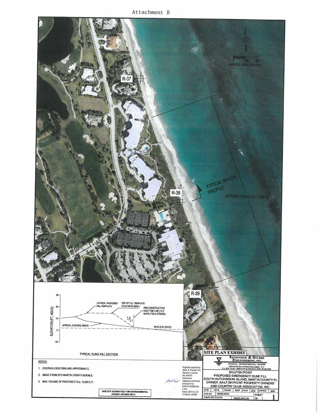
1 MARTIN COUNTY BOARD OF COUNTY COMMISSIONERS 4 S.E. MONTEREY ROAD STUART, FL DOUG SMITH Commissioner, District ED FIELDING Commissioner, District ANNE SCOTT Commissioner, District 3 SARAH HEARD Commissioner, District 4 JOHN HADDOX Commissioner, District TARYN KRYZDA, CPM County Administrator MICHAEL D. DURHAM County Attorney December, 4 Telephone: Fax: pknott@martin.fl.us Mr. Darwin Stubbs, P.E. Isiminger & Stubbs Engineering, Inc. 649 U.S. Highway, Suite 9 North Palm Beach, FL 3348 Dear Mr. Stubbs: Pursuant to Chapter 6.8 F.S. and Chapter.4 of Ordinance 8 of the Code of Laws and Ordinances of Martin County, Martin County approves and issues this emergency permit for mechanical sand placement of beach compatible sand above Mean High Water to you as agent for: Sailfish Point Property Owners and Country Club (POCC) SE Sailfish Point Boulevard Stuart FL, Sailfish Point POCC has authorization from all upland property owners to act as their agent in this project. Authorization from the Sailfish Point POCC is included in Attachment A. The project can be generally described as the placement of beach compatible sand along the eroded shoreline from approximately 34 feet south of DEP reference monument R-37 to R-39. Additional details can be found in the attached project aerial exhibit (Attachment B). The project construction will be initiated as soon as possible after this permit s effective date and all work will be completed by February 8,. The maximum amount of fill authorized by this permit is, cy. This permit is being issued based on documentation of extreme and accelerated erosion within the project limits. The project will be constructed in a manner to minimize adverse impacts to the coastal system native vegetation, associated species and adjacent properties. As the placement of beach compatible sand is not considered rigid coastal armoring, the sand may be left in place with no further permitting required. TELEPHONE WEB ADDRESS All sand placed will come from the County approved Stewart Mining as stated in contract AR -48. Sailfish Point POCC will ensure that Inspectors will be present onsite while the project is underway, and will of 9 EngL79
2 visually inspect a representative sample of truckloads each day (minimum % of trucks daily) prior to placement to ensure consistency of the material. A survey documenting current beach conditions and locating MHW will be conducted by Sailfish Point POCC prior to placement. The location of MHW will be staked at ft. intervals along the entire project length. Rapidly changing conditions and potential major shifts in MHW will be taken into consideration as the project progresses. No rigid shoreline protection is authorized by this permit. Please submit project updates to the County on a weekly basis. These reports and any additional questions may be submitted via at kfitzpat@martin.fl.us. Sincerely, Kathy FitzPatrick, P.E. Coastal Engineer of 9 EngL79
3 3 of 9
4 4 of 9

5 Mark A. Powell December, 4 Isiminger & Stubbs Engineering, Inc. 649 U.S. Highway, Suite 9 North Palm Beach, FL 3348 Re: Native Beach and Upland Source Soil Sample Results Sailfish Point Navigation Channel Dredge/Dune Fill Project Sailfish Point, Martin County, FL Dear Mr. Powell:. (EAI) was contracted by Isiminger & Stubbs Engineering, Inc. to process six (6) sediment samples that were collected on November, 4 and delivered to EAI s laboratory on November, 4. The Scope of Work included grain size analysis to determine mean grain size (mm), sorting value, silt content (%), and shell content (%). The samples were also analyzed for wet Munsell color and carbonate content (%). This report presents the results of those analyses. Results Mean grain size values ranged from.3 mm from Sample R-38 to.46 from Sample Stewart Mine. Sample R-36 had the lowest sorting value (.6) and Sample Stewart Mine had the highest (.). Silt content ranged from.% (Sample R-36) to.4% (Sample Stewart Mine). Only one sample, R-4, had any shell content (.%). Color values were either YR/ or YR6/. All samples were compliant with sediment compliance specifications set forth in the Sediment Quality Assurance and Quality Control Plan for the Sailfish Point Navigation Channel Maintenance Dredging/Dune Fill Project (FDEP JCP # JC): silt content was less than %, shell content was less than %, and Munsell color value was or lighter. The results for R-36, R-37, R-38, R-39, and R-4 Construction Berm Samples and the Stewart Mine - Beach Stockpile Upland Source Sample were certified by our professional geologist on December, 4 (see attachment) and are fully compliant with professional standards.. P.O. Box 4 Jensen Beach, Florida 3498 Phone: (77) Fax: (77) info@ecological-associates.com Visit us at of 9
 Sediment Texture (Grain Size) Sorting Value Silt Content (%)² Shell Content (%)³.34.")
6 Sample Number R-36 Construction Berm Sample R-37 Construction Berm Sample R-38 Construction Berm Sample R-39 Construction Berm Sample R-4 Construction Berm Sample Stewart Mine- Beach Stockpile Upland Source. Sediment Granularmetric Analysis Summary Table Mean Grain Size (mm) Sediment Texture (Grain Size) Sorting Value Silt Content (%)² Shell Content (%)³ Wet Munsell Color Value YR/ YR/ YR6/ YR/ YR/ YR6/ Compliant with QA/QC Specifications Additional granularmetric statistics are available on the attached report tables. Percentage of sediment (by weight) passing the U.S.A Standard Testing sieve #3 (63 micrometer). 3 Percentage of sediment (by weight) retained on the U.S.A Standard Testing sieve #4 (4.7 mm).. appreciates the opportunity to be of service to Isiminger & Stubbs Engineering, Inc. Should you have any questions regarding this report or accompanying data, I can be reached at (77) Yes Yes Yes Yes Yes Yes Sincerely, Carrie Goethel Lab Manager cc: Bob Ernest/EAI R. Erik Martin/EAI Niki Desjardin/EAI 6 of 9
7 7 of 9
8 Granularmetric Report Project Name: Sailfish Point Dune Fill Project Sample Name: R-36 Construction Berm Sample Analysis Date: -4-4 Easting (ft): Northing (ft): Coordinate System: 48 Sunview Terrace (77) fax (77) Elevation (ft): GRANULARMETRIC REPORT SAILFISH POINT NOV. 4.GPJ FL DEP ROSS.GDT //4 USCS: Florida State Plane East Sieve Number Munsell: 74.6 (Phi) Wet - YR-/ Dry - YR-7/ Dry Weight (g): Wash Weight (g): Pan (g): Sieve Loss (%): (Millimeters). Grams # -.4 #3 -. 3/4" /8" /6" /6" Phi.4 Moment Statistics Phi 6. Mean Phi.6 Phi.9 Mean mm.34 Phi.8 Sorting.6 Fines (%): % Weight Phi 7. Organics (%): Carbonates (%):.3 Skewness Cum. Grams Phi 84.7 Shells (%): C. % Weight Phi 9.6 Kurtosis of 9
9 PHI s Standard s /4/8-3 / Hydrometer Percent Finer By Weight Percent Coarser By Weight SIEVE ANALYSIS SAILFISH POINT NOV. 4.GPJ FL DEP ROSS.GDT //4 Gravel Sand Millimeters Coarse Fine Coarse Medium Fine Sample Symbol Elev. (ft) USCS % Fines % Organics % Carbonates Median Mean Skew Kurt Sort Sample Information # -.4 R-36 Construction Berm Sample # Project Name: Sailfish Point Dune Fill Project Analysis Date: -4-4 Easting (X, ft): Sunview Terrace Northing (Y, ft): (77) fax (77) Horizontal System: NAD 983 Vertical System:.. Silt and Clay 9. 9 of 9
10 Granularmetric Report Project Name: Sailfish Point Dune Fill Project Sample Name: R-37 Construction Berm Sample Analysis Date: -4-4 Easting (ft): Northing (ft): Coordinate System: 48 Sunview Terrace (77) fax (77) Elevation (ft): GRANULARMETRIC REPORT SAILFISH POINT NOV. 4.GPJ FL DEP ROSS.GDT //4 USCS: Florida State Plane East Sieve Number Munsell: 64. (Phi) Wet - YR-/ Dry - YR-7/ Dry Weight (g): Wash Weight (g): Pan (g): Sieve Loss (%): 64.. (Millimeters). Grams # -.6 # /4" /8" /6" /6" Phi.4 Moment Statistics Phi 6.6 Mean Phi.7 Phi.94 Mean mm.34 Phi.8 Sorting.9 Fines (%): % Weight Phi 7.8 Organics (%): Carbonates (%):.4 Skewness Cum. Grams Phi 84.4 Shells (%): C. % Weight Phi 9.9 Kurtosis of 9
11 PHI s Standard s /4/8-3 / Hydrometer Percent Finer By Weight Percent Coarser By Weight SIEVE ANALYSIS SAILFISH POINT NOV. 4.GPJ FL DEP ROSS.GDT //4 Gravel Sand Millimeters Coarse Fine Coarse Medium Fine Sample Symbol Elev. (ft) USCS % Fines % Organics % Carbonates Median Mean Skew Kurt Sort Sample Information # -.6 R-37 Construction Berm Sample # Project Name: Sailfish Point Dune Fill Project Analysis Date: -4-4 Easting (X, ft): Sunview Terrace Northing (Y, ft): (77) fax (77) Horizontal System: NAD 983 Vertical System:.. Silt and Clay 9. of 9
12 Granularmetric Report Project Name: Sailfish Point Dune Fill Project Sample Name: R-38 Construction Berm Sample Analysis Date: --4 Easting (ft): Northing (ft): Coordinate System: 48 Sunview Terrace (77) fax (77) Elevation (ft): GRANULARMETRIC REPORT SAILFISH POINT NOV. 4.GPJ FL DEP ROSS.GDT //4 USCS: Florida State Plane East Sieve Number Munsell: 6.8 (Phi) Wet - YR-6/ Dry - YR-7/ Dry Weight (g): Wash Weight (g): Pan (g): Sieve Loss (%): 6.8. (Millimeters).3 Grams # -.3 #3 -. 3/4" /8" /6" /6" Phi.8 Moment Statistics Phi 6.34 Mean Phi.74 Phi. Mean mm.3 Phi.73 Sorting.6 Fines (%): % Weight Phi 7.3 Organics (%): Carbonates (%):.4 Skewness Cum. Grams Phi 84.6 Shells (%): C. % Weight Phi 9.73 Kurtosis of 9
13 PHI s Standard s /4/8-3 / Hydrometer Percent Finer By Weight Percent Coarser By Weight SIEVE ANALYSIS SAILFISH POINT NOV. 4.GPJ FL DEP ROSS.GDT //4 Gravel Sand Millimeters Coarse Fine Coarse Medium Fine Sample Symbol Elev. (ft) USCS % Fines % Organics % Carbonates Median Mean Skew Kurt Sort Sample Information # -.3 R-38 Construction Berm Sample # Project Name: Sailfish Point Dune Fill Project Analysis Date: --4 Easting (X, ft): Sunview Terrace Northing (Y, ft): (77) fax (77) Horizontal System: NAD 983 Vertical System:.. Silt and Clay 9. 3 of 9
14 Granularmetric Report Project Name: Sailfish Point Dune Fill Project Sample Name: R-39 Construction Berm Sample Analysis Date: --4 Easting (ft): Northing (ft): Coordinate System: 48 Sunview Terrace (77) fax (77) Elevation (ft): GRANULARMETRIC REPORT SAILFISH POINT NOV. 4.GPJ FL DEP ROSS.GDT //4 USCS: Florida State Plane East Sieve Number Munsell: 89. (Phi) Wet - YR-/ Dry - YR-7/ Dry Weight (g): Wash Weight (g): Pan (g): Sieve Loss (%): 89.. (Millimeters).4 Grams # -.6 #3 -. 3/4" /8" /6" /6" Phi.63 Moment Statistics Phi 6.8 Mean Phi.9 Phi.9 Mean mm.33 Phi.7 Sorting.8 Fines (%): % Weight Phi 7.9 Organics (%): Carbonates (%):.99 Skewness Cum. Grams Phi 84.6 Shells (%): C. % Weight Phi 9.6 Kurtosis of 9
15 PHI s Standard s /4/8-3 / Hydrometer Percent Finer By Weight Percent Coarser By Weight SIEVE ANALYSIS SAILFISH POINT NOV. 4.GPJ FL DEP ROSS.GDT //4 Gravel Sand Millimeters Coarse Fine Coarse Medium Fine Sample Symbol Elev. (ft) USCS % Fines % Organics % Carbonates Median Mean Skew Kurt Sort Sample Information # -.6 R-39 Construction Berm Sample # Project Name: Sailfish Point Dune Fill Project Analysis Date: --4 Easting (X, ft): Sunview Terrace Northing (Y, ft): (77) fax (77) Horizontal System: NAD 983 Vertical System:.. Silt and Clay 9. of 9
16 Granularmetric Report Project Name: Sailfish Point Dune Fill Project Sample Name: R-4 Construction Berm Sample Analysis Date: --4 Easting (ft): Northing (ft): Coordinate System: 48 Sunview Terrace (77) fax (77) Elevation (ft): GRANULARMETRIC REPORT SAILFISH POINT NOV. 4.GPJ FL DEP ROSS.GDT //4 USCS: Florida State Plane East Sieve Number Munsell: 8.99 (Phi) Wet - YR-/ Dry - YR-7/ Dry Weight (g): Wash Weight (g): Pan (g): Sieve Loss (%): (Millimeters).7 Grams # -.9 # /4" /8" /6" /6" Phi.63 Moment Statistics Phi 6.6 Mean Phi. Phi.93 Mean mm.3 Phi. Sorting.66 Fines (%): % Weight Phi 7. Organics (%): Carbonates (%):. Skewness Cum. Grams Phi Shells (%): C. % Weight Phi 9.43 Kurtosis of 9
17 PHI s Standard s /4/8-3 / Hydrometer Percent Finer By Weight Percent Coarser By Weight SIEVE ANALYSIS SAILFISH POINT NOV. 4.GPJ FL DEP ROSS.GDT //4 Gravel Sand Millimeters Coarse Fine Coarse Medium Fine Sample Symbol Elev. (ft) USCS % Fines % Organics % Carbonates Median Mean Skew Kurt Sort Sample Information # -.9 R-4 Construction Berm Sample # Project Name: Sailfish Point Dune Fill Project Analysis Date: --4 Easting (X, ft): Sunview Terrace Northing (Y, ft): (77) fax (77) Horizontal System: NAD 983 Vertical System:.. Silt and Clay 9. 7 of 9
18 Granularmetric Report Project Name: Sailfish Point Dune Fill Project Sample Name: Stewart Mine Berm Stock Pile Upland Source Analysis Date: --4 Easting (ft): Northing (ft): Coordinate System: 48 Sunview Terrace (77) fax (77) Elevation (ft): GRANULARMETRIC REPORT SAILFISH POINT NOV. 4.GPJ FL DEP ROSS.GDT //4 USCS: SW Sieve Number Munsell: (Phi) Wet - YR-6/ Dry - YR-8/ Dry Weight (g): Wash Weight (g): Pan (g): Sieve Loss (%): (Millimeters) Florida State Plane East. Grams # -.8 # /4" /8" /6" /6" Phi.8 Moment Statistics Phi 6.3 Mean Phi. Phi.7 Mean mm.46 Phi.37 Sorting. Fines (%): % Weight Phi 7.4 Organics (%): Carbonates (%):.7 Skewness Cum. Grams Phi Shells (%): C. % Weight Phi Kurtosis.3. 8 of 9
19 PHI s Standard s /4/8-3 / Hydrometer Percent Finer By Weight Percent Coarser By Weight SIEVE ANALYSIS SAILFISH POINT NOV. 4.GPJ FL DEP ROSS.GDT //4 Gravel Sand Millimeters Coarse Fine Coarse Medium Fine Sample Symbol Elev. (ft) USCS % Fines % Organics % Carbonates Median Mean Skew Kurt Sort Sample Information # -.8 Stewart Mine Berm Stock Pile Upland Source SW # Project Name: Sailfish Point Dune Fill Project Analysis Date: --4 Easting (X, ft): 48 Sunview Terrace Northing (Y, ft): (77) fax (77) Horizontal System: NAD 983 Vertical System:.. Silt and Clay 9. 9 of 9
Potential Upland Sand Sources to Support Southwest Florida Beach Projects
 1 of 21 Potential Upland Sand Sources to Support Southwest Florida Beach Projects Depending on project size and timeline, upland sand sources (mines) may be viable for beach construction projects in southwest
SAND SEARCH AND FILL MATERIAL QA/QC PLANS FOR BEACH NOURISHMENT PROJECTS IN FLORIDA
 SAND SEARCH AND FILL MATERIAL QA/QC PLANS FOR BEACH NOURISHMENT PROJECTS IN FLORIDA Jennifer L. Koch (Coastal Geologist), Beth M. Forrest (Coastal Geologist) and Robert M. Brantly (Program Administrator)
BALD HEAD CREEK BORROW SITE EXPANSION AND GEOTECHNICAL ANALYSIS (OLSEN AND ASSOCIATES, INC. APRIL
 APPENDIX F BALD HEAD CREEK BORROW SITE EXPANSION AND GEOTECHNICAL ANALYSIS (OLSEN AND ASSOCIATES, INC. APRIL 24) Final Environmental Impact Statement Village of Bald Head Island Shoreline Protection Project
ST. LUCIE COUNTY, FLORIDA
 ST. LUCIE COUNTY, FLORIDA COASTAL STORM RISK MANAGEMENT PROJECT DRAFT INTEGRATED FEASIBILITY STUDY AND ENVIRONMENTAL ASSESSMENT APPENDIX D Geotechnical APRIL 2016 TABLE OF CONTENTS 1 Background... 3 1.1
Plans & Specs Level Offshore Sand Search Investigation, South Peninsula Volusia County, Florida U.S.A.
 Plans & Specs Level Offshore Sand Search Investigation, South Peninsula Volusia County, Florida U.S.A. Randall W. Parkinson, Ph.D., P.G., and Leighann Budde Coastal Technology Corporation Melbourne, FL
Woodford County Erosion Prevention Plan and Permit. Application #
 Woodford County Erosion Prevention Plan and Permit Application # Date Instructions: Applicant will complete Parts A and B, and attach a proposed site diagram. This diagram must be completed in accordance
Geology for Engineers Sediment Size Distribution, Sedimentary Environments, and Stream Transport
 Name 89.325 Geology for Engineers Sediment Size Distribution, Sedimentary Environments, and Stream Transport I. Introduction The study of sediments is concerned with 1. the physical conditions of a sediment,
FORENSIC GEOLOGY SAND SIZE-DISTRIBUTIONS AS INDICATORS OF CRIME SCENE LOCATIONS
 I. Introduction 89.215 FORENSIC GEOLOGY SAND SIZE-DISTRIBUTIONS AS INDICATORS OF CRIME SCENE LOCATIONS If you think about the world around you sand, and other sediments, occur in many environments. For
Appendix D Geotechnical
 USACE JACKSONVIE DISTRICT Appendix D Geotechnical LEE COUNTY GASPARIA SHORE PROTECTION PROJECT 934 REPORT June 216 TABLE OF CONTENTS 1 Background... 1 1.1 Regional Geology... 1 1.2 Local Geology... 2 2
Lincoln County Board of Commissioner s Agenda Item Cover Sheet
 Lincoln County Board of Commissioner s Agenda Item Cover Sheet Board Meeting Date: Agenda Item Type: Consent Agenda: Public Hearing: Regular Agenda: Presentation Time (est): Submitting Person: Phone Number/Ext:
MODELING OF EROSION CONTROL ALTERNATIVES AT STUMP PASS, CHARLOTTE COUNTY
 2014 NATIONAL CONFERENCE ON BEACH PRESERVATION TECHNOLOGY FEBRUARY 13, 2014 MODELING OF EROSION CONTROL ALTERNATIVES AT STUMP PASS, CHARLOTTE COUNTY 1 VADIM ALYMOV, PH.D. 2 CHUCK MOPPS 3 MICHAEL POFF,
TREASURE COAST REGIONAL PLANNING COUNCIL M E M O R A N D U M. To: Council Members AGENDA ITEM 4B10
 TREASURE COAST REGIONAL PLANNING COUNCIL M E M O R A N D U M To: Council Members AGENDA ITEM 4B10 From: Date: Subject: Staff December 14, 2018 Council Meeting Local Government Comprehensive Plan Review
 Project: ITHACA-TOMPKINS REGIONAL AIRPORT EXPANSION Project Location: ITHACA, NY Project Number: 218-34 Key to Soil Symbols and Terms TERMS DESCRIBING CONSISTENCY OR CONDITION COARSE-GRAINED SOILS (major
Ardaman & Associates, Inc. Geotechnical, Environmental and Materials Consultants
 SUBSURFACE SOIL EXPLORATION 42-INCH FORCE MAIN REPLACEMENT CHIQUITA BOULEVARD S AND SW 34 TH STREET CAPE CORAL, LEE COUNTY, FLORIDA Ardaman & Associates, Inc. Geotechnical, Environmental and Materials
Tikrit University College of Engineering Civil engineering Department
 Tikrit University SOIL CLASSIFICATION College of Engineering Civil engineering Department Soil Mechanics 3 rd Class Lecture notes Up Copyrights 2016 Classification of soil is the separation of soil into
MECHANICAL SIZE ANALYSIS OF SEDIMENTS
 MECHANICAL SIZE ANALYSIS OF SEDIMENTS I. Introduction The study of sediments is concerned with 1. the physical conditions of a sediment, whether glacial, fluvial, marine, etc; 2. the time of formation
Alexandra Carvalho, Ph.D., GISP Kathy Fitzpatrick, P.E.
 Coastal Data Organization for Project Management and Coastal Planning Martin County, Florida Alexandra Carvalho, Ph.D., GISP Kathy Fitzpatrick, P.E. Outline County Coastal Programs Coastal Geodatabase
ATTACHMENT A WEAVER BOTTOMS SEDIMENT BASIN MAINTENANCE PROJECT PROJECT REPORT SUMMARY (APRIL 7, 2014)
") ATTACHMENT A WEAVER BOTTOMS SEDIMENT BASIN MAINTENANCE PROJECT PROJECT REPORT SUMMARY (APRIL 7, 2014) PRE-PROJECT DREDGE MATERIAL SEDIMENT CORE AND BASELINE CONTAMINANT ANALYSIS PREPARED BY BRAUN INTERTEC
ATTACHMENT A WEAVER BOTTOMS SEDIMENT BASIN MAINTENANCE PROJECT PROJECT REPORT SUMMARY (APRIL 7, 2014) PRE-PROJECT DREDGE MATERIAL SEDIMENT CORE AND BASELINE CONTAMINANT ANALYSIS PREPARED BY BRAUN INTERTEC
J.H. Campbell Generating Facility Pond A - Location Restriction Certification Report
 J.H. Campbell Generating Facility Pond A - Location Restriction Certification Report Pursuant to: 40 CFR 257.60 40 CFR 257.61 40 CFR 257.62 40 CFR 257.63 40 CFR 257.64 Submitted to: Consumers Energy Company
ST. JOHNS COUNTY, FLORIDA
 ST. JOHNS COUNTY, FLORIDA South onte Vedra Beach, Vilano Beach, and Summer Haven Reaches COASTAL STORM RISK MANAGEMENT ROJECT DRAFT INTEGRATED FEASIBILITY STUDY AND ENVIRONMENTAL ASSESSMENT AENDIX D Geotechnical
May 22, Mr. Tim Tyler TRWME Properties, LLC 240 Hwy. 65 N Conway, AR RE: Royal Oaks Vista Subdivision Site. Dear Mr.
 May 22, 2008 Mr. Tim Tyler TRWME Properties, LLC 240 Hwy. 65 N Conway, AR 72032 RE: Royal Oaks Vista Subdivision Site AFIN: 12-00272 NPDES Permit No.: ARR150472 Dear Mr. Tyler: On March 26, 2008, I performed
Introduction to Soil Mechanics Geotechnical Engineering-II
 Introduction to Soil Mechanics Geotechnical Engineering-II ground SIVA Dr. Attaullah Shah 1 Soil Formation Soil derives from Latin word Solum having same meanings as our modern world. From Geologist point
Ardaman & Associates, Inc. Geotechnical, Environmental and Materials Consultants
 SUBSURFACE SOIL EXPLORATION DRAINAGE IMPROVEMENTS TO THE HENDRY COUNTY, FLORIDA Ardaman & Associates, Inc. Geotechnical, Environmental and Materials Consultants OFFICES Orlando, 88 S. Orange Avenue, Orlando,
RECENT SEDIMENTS OF CALIFORNIA PART A. INTRODUCTION AND GRAIN SIZE ANALYSIS HYDRAULIC ENGINEERING LABORATORY COLLEGE OF ENGINEERING C.
 HEL-2-19! 9* I 1 f RECENT SEDIMENTS OF BOLINAS BAY CALIFORNIA PART A. INTRODUCTION AND GRAIN SIZE ANALYSIS by C. ISSELHARDT L. OSUCH RWILDE. HYDRAULIC ENGINEERING LABORATORY COLLEGE OF ENGINEERING UNIVERSITY
BOARD OF COUNTY COMMISSIONERS. December 10, 1991
 ANATEE COUNTY BOARD OF COUNTY COMMISSIONERS December 10, 1991 Mr. W i l l i a m Hinkley, A d m i n i s t r a t o r S o l i d Waste Section F l o r i d a Department of Environmental Regulation v, ^ Twin
Soil Map Polk County, Florida
 Soil Map Polk County, Florida 28 9' 21'' 28 8' 23'' 3113000 3113200 3113400 3113600 3113800 3114000 3114200 3114400 3114600 81 51' 19'' 81 51' 19'' 416000 416000 ± 416200 416200 68 416400 68 416400 7 13
ENGINEERING APPROACHES TO SHORELINE PLACEMENT FROM COAST TO COAST
 ENGINEERING APPROACHES TO SHORELINE PLACEMENT FROM COAST TO COAST 237 237 237 217 217 217 200 200 200 0 0 0 163 163 163 131 132 122 80 119 27 252 174.59 83 36 118 110 135 120 112 92 56 62 102 130 Comparing
September 21, 2004 GeoInsight Project
 GeoInsight, Inc. GeoInsight, Inc. GeoInsight, Inc. 75 Gilcreast Road, Suite 210 319 Littleton Road, Suite 105 Corporate Ten Center Londonderry, NH 03053-3566 Westford, MA 01886 1781 Highland Avenue, Suite
MAINTENANCE DREDGE BENTHIC ASSESSMENT SUNSET POINT FARM LLC LONG POINT KEY MONROE COUNTY, FLORIDA. Prepared by:
 MAINTENANCE DREDGE BENTHIC ASSESSMENT SUNSET POINT FARM LLC LONG POINT KEY MONROE COUNTY, FLORIDA Prepared by: December 11, 2016 INTRODUCTION The owners of the Sunset Point Farms LLC, located on the northern
7. STREAMBED TEXTURE ANALYSIS
 Geomorphology 7. Streambed Texture Analysis 7. STREAMBED TEXTURE ANALYSIS 50 Points The purpose of this exercise is to analyze the size characteristics of the sediment samples collected in the field. We
Template for Sediment and Erosion Control Plan General Instructions. Section Instructions
 Template for Sediment and Erosion Control Plan General Instructions Introduction: Soil erosion and sediment deposition from farmlands can contribute to degraded surface water quality. Sediment delivery
NAPLES MUNICIPAL AIRPORT
 NAPLES MUNICIPAL AIRPORT NAPLES MUNICIPAL AIRPORT (APF) TAXIWAY D REALIGNMENT AND DRAINAGE IMPROVEMENTS NORTH QUADRANT ADDENDUM NUMBER TWO March, The following Addendum is hereby made a part of the Plans
Template for Sediment and Erosion Control Plan General Instructions
 Template for Sediment and Erosion Control Plan General Instructions Introduction: Soil erosion and sediment deposition from farmlands can contribute to degraded surface water quality. Sediment delivery
A Sedimentological and Granulometric Atlas of the Beach Sediments of Florida s Southwest Coast and Keys
 A Sedimentological and Granulometric Atlas of the Beach Sediments of Florida s Southwest Coast and Keys Daniel C. Phelps, Michelle M. L. Ladle, and Adel A. Dabous The Florida Geological Survey Coastal
Dr. L. I. N. de Silva. Student Name Registration Number: Assessed By: Lecturers Remarks
 Module - CE 2042 Soil Mechanics and Geology-1 Assignment Tests for Particle Size Distribution Analysis Marks 10% Learning Ability to conduct particle size distribution analysis of soils Outcome Ability
FILL SUITABILITY CHARACTERIZATION OF A COMPLEX COASTAL AREA: DARE COUNTY, NORTH CAROLINA
 FILL SUITABILITY CHARACTERIZATION OF A COMPLEX COASTAL AREA: DARE COUNTY, NORTH CAROLINA Donald K. Stauble 1, William Birkemeier, Michael F. Forte and William A. Dennis 3 ABSTRACT As part of the design
MIDDLESEX COUNTY Department of Planning and Community Development P.O. Box 427, Saluda, VA Phone: Fax:
 MIDDLESEX COUNTY Department of Planning and Community Development P.O. Box 427, Saluda, VA 23149 Phone: 804-758-3382 Fax: 804-758-0061 LAND DISTURBANCE PERMIT SUBMISSION REQUIREMENTS In order to expedite
SUPPLEMENTARY INVESTIGATION AND LABORATORY TESTING Aggregate Resource Evaluation Proposed Bernand Quarry San Diego County, California
 October 3, 2 Mr. Mark San Agustin Project No. 28-- Home Land Investments Document No. -92 2239 Curlew Street San Diego, CA 92 SUBJECT: SUPPLEMENTARY INVESTIGATION AND LABORATORY TESTING Aggregate Resource
Field Exploration. March 31, J-U-B ENGINEERS, Inc. 115 Northstar Avenue Twin Falls, Idaho Attn: Mr. Tracy Ahrens, P. E. E:
 March 31, 201 11 Northstar Avenue 83301 Attn: Mr. Tracy Ahrens, P. E. E: taa@jub.com Re: Geotechnical Data Report Preliminary Phase 1 Field Exploration Revision No. 1 Proposed Rapid Infiltration Basin
FYI, issued today. Thanks.
 From: To: Subject: Date: Attachments: Amy Brennan Laura Donaldson; Michelle Hopkins; Jan Burke; Dave Kramer; Carolyn Pina; Steven Lopes; Cliff Ondercin; Albert A. Gagne; Kim Dymond; David Sauskojus FW:
Mark H. Horwitz Ping Wang PhD Coastal Research Laboratory, School of Geosciences University of South Florida
 Mark H. Horwitz Ping Wang PhD Coastal Research Laboratory, School of Geosciences University of South Florida American Shore & Beach Preservation Association 2015 National Coastal Conference, New Orleans,
GEOSYNTEC CONSULTANTS
 GEOSYNTEC CONSULTANTS 2100 Main Street, Suite 150 Huntington Beach, CA 92648 USA Tel (714) 969-0800 Fax (714) 969-0820 15 February 2006 Ms. Tamara Zeier, P.E. Project Manager Project Navigator, Ltd. One
CEMEX Eliot Quarry. Lake A Evaluation Report. Alameda County, California
 May 7, 2015 May 7, 2015 Project No. GT13-16 Prepared for: CEMEX 5180 Golden Foothills, Parkway El Dorado Hills, California 95762 7400 Shoreline Drive, Ste. 6 Stockton, California 95219 Tel: 209-472-1822
NEWS RELEASE UNDER SECTION 404 OF THE CLEAN WATER ACT (33 USC 1344) ACTION NUMBER SPA ABQ
 ACTION NUMBER SPA ABQ") PUBLIC NOTICE Public Notice Issue Date: //6/07 Albuquerque District Comments due: /6/08 NEWS RELEASE UNDER SECTION 0 OF THE CLEAN WATER ACT ( USC ) ACTION NUMBER SPA-06-00-ABQ BANK STABILIZATION ALONG
PUBLIC NOTICE Public Notice Issue Date: //6/07 Albuquerque District Comments due: /6/08 NEWS RELEASE UNDER SECTION 0 OF THE CLEAN WATER ACT ( USC ) ACTION NUMBER SPA-06-00-ABQ BANK STABILIZATION ALONG
Slope Stability Evaluation Ground Anchor Construction Area White Point Landslide San Pedro District Los Angeles, California.
 Slope Stability Evaluation Ground Anchor Construction Area White Point Landslide San Pedro District Los Angeles, California Submitted To: Mr. Gene Edwards City of Los Angeles Department of Public Works
FINAL REPORT GEOPHYSICAL INVESTIGATION VILLAGE ALHAMBRA RETENTION POND SITE THE VILLAGES, FLORIDA
 FINAL REPORT GEOPHYSICAL INVESTIGATION VILLAGE ALHAMBRA RETENTION POND SITE THE VILLAGES, FLORIDA Prepared for Andreyev Engineering, Inc. Oxford, FL Prepared by GeoView, Inc. St. Petersburg, FL August
Appendix K.2: Sediment Management Excerpt from South Orange County Hydromodification Management Plan
 Appendix K.2: Sediment Management Excerpt from South Orange County Hydromodification Management Plan 4 Sediment Supply Management Requirements Permit Order R9-2013-0001 as amended by Order No. R9-2015-0001Section
Exercise 3 Texture of siliciclastic sediments
 Exercise 3 Texture of siliciclastic sediments Siliciclastic sediments are derived from the weathering and erosion of preexisting rocks. Once a sedimentary particle is loosened from its parent rock, it
CITY OF CAPE CORAL NORTH 2 UTILITIES EXTENSION PROJECT CONTRACT 3
 GEOTECHNICAL REPORT CITY OF CAPE CORAL NORTH UTILITIES EXTENSION PROJECT CONTRACT City of Cape Coral Procurement Division Cultural Park Boulevard, nd Floor Cape Coral, FL ISSUED FOR BID VOLUME of GEOTECHNICAL
M E M O R A N D U M. Mr. Jonathan K. Thrasher, P.E., Mr. Ian Kinnear, P.E. (FL) PSI
 PSI") M E M O R A N D U M TO: FROM: Mr. Mark Schilling Gulf Interstate Engineering Mr. Jonathan K. Thrasher, P.E., Mr. Ian Kinnear, P.E. (FL) PSI DATE: November 11, 2014 RE: Summary of Findings Geotechnical
M E M O R A N D U M TO: FROM: Mr. Mark Schilling Gulf Interstate Engineering Mr. Jonathan K. Thrasher, P.E., Mr. Ian Kinnear, P.E. (FL) PSI DATE: November 11, 2014 RE: Summary of Findings Geotechnical
December 16, Mr. Lee Hughes Southwest Florida Water Management District Tampa Service Office 7601 Highway 301 North Tampa, FL 33637
 December 16, 2015 Mr. Lee Hughes Southwest Florida Water Management District Tampa Service Office 7601 Highway 301 North Tampa, FL 33637 RE: Response to SWFWMD Supplemental Information Request Dear Mr.
Seagrass Transplantation & Environmental & Marine Consulting Services, Inc. Drew Campbell, Vice President & Lead Scientst.
 Indian River Lagoon Symposium Seagrass Transplantation & Project Considerations Environmental & Marine Consulting Services, Inc. Drew Campbell, Vice President & Lead Scientst March 26 th, 2013 Regulatory
Coastal Sediment Properties and Longshore Sediment Transport
 Coastal Sediment Properties and Longshore Sediment Transport Julie Rosati Julie.D.Rosati@erdc.usace.army.mil 601-634-3005 Coastal Planning Course Lesson #8 Tuesday 8:00-9:00 am CEM III-1, III-2 1. Coastal
TESTING PROTOCAL. Via & US Mail. April 30, 2010
 Wiss, Janney, Elstner Associates, Inc. 330 Pfingsten Road Northbrook, Illinois 60062 847.272.7400 tel 847.291.5189 fax www.wje.com Via Email & US Mail General Manager 318 West Washington Street Valders
Custom Soil Resource Report for Forrest County, Mississippi
 United States Department of Agriculture Natural Resources Conservation Service A product of the National Cooperative Soil Survey, a joint effort of the United States Department of Agriculture and other
SAND. By A S M Fahad Hossain Assistant Professor Department of Civil Engineering, AUST
 SAND By A S M Fahad Hossain Assistant Professor Department of Civil Engineering, AUST Definition Sand is a loose, fragmented, naturally-occurring material consisting of vary small particle (fine to medium
Sabal Trail Pipeline Project Evaluation of Karst Topography and Sinkhole Potential for Pipeline and Facilities
 November 11, 2014 Sabal Trail Pipeline Project Evaluation of Karst Topography and Sinkhole Potential for Pipeline and Facilities Gulf Interstate Engineering Attention: Mr. Denys Stavnychyi - Project Engineer
CCR Rule Annual Inspection Report (cont.) 2
 2") The inspection findings consisted of maintenance items and items that were not observed to be signs or potential signs of significant structural weakness. No deficiencies or disrupting conditions that
The inspection findings consisted of maintenance items and items that were not observed to be signs or potential signs of significant structural weakness. No deficiencies or disrupting conditions that
ENGINEERING WITH NATURE: NEARSHORE BERM PLACEMENTS AT FORT MYERS BEACH AND PERDIDO KEY, FLORIDA, USA
 1 ENGINEERING WITH NATURE: NEARSHORE BERM PLACEMENTS AT FORT MYERS BEACH AND PERDIDO KEY, FLORIDA, USA KATHERINE E. BRUTSCHÉ 1, PING WANG 2, JULIE D. ROSATI 1, CHERYL E. POLLOCK 1 1. U.S. Army Engineer
Randall W. Parkinson, Ph.D., P.G. Institute of Water and Environment Florida International University
 An Update on Adaptation Action Activities Undertaken Since Completion of the City of Satellite Beach (FL) Vulnerability Assessment to Rising Seas (2010) Randall W. Parkinson, Ph.D., P.G. Institute of Water
Amelia Island, Nassau County, FL Marine Geological Field Investigation for Offshore Geologic Model Support
 Amelia Island, Nassau County, FL for Offshore Geologic Model Support BOEM Notice of Scientific Research NA15 001 Submitted to: Bureau of Ocean Energy Management (BOEM) Florida Department of Environmental
Tom Blackman Project Lead. Mékell Mikell Communications Representative
 Sediment Cleanup Middle River Complex, 2016-17 Season 1 Project Photo Tour Updated November 15, 2016 Tom Blackman Project Lead Mékell Mikell Communications Representative 1 Sediment Cleanup - Season 1
Re: Steep Slope Assessment for 2465 Waverly Drive, Blind Bay, BC; Legal Address: Lot 39, Section 18, Township 22, Range 10, Plan 25579, W6M, KDYD.
 OEL File 1563-1 May 30, 2017 Doug Wall PO Box 774 Salmon Arm, BC V1E 4N7 Re: Steep Slope Assessment for 2465 Waverly Drive, Blind Bay, BC; Legal Address: Lot 39, Section 18, Township 22, Range 10, Plan
TPDES: Soil, Erosion and Sedimentation Methods
 SAWS TPDES: Soil, Erosion and Sedimentation Methods Philip Handley Supervisor-Resource Protection & Compliance August 25, 2014 TPDES: Soil, Erosion and Sedimentation Methods Soil Common term: Dirt Common
Dry Muliwai Sample Location Map
 DMM2 DMM1 P:\AthruR\K838-Makua\GIS\Layouts\Dry Muliwai.mxd.mxd - 3/26/3 - JC DMM3 5 Dry Muliwai Sample Location Map Figure 2-4 P:\AthruR\K838-Makua\GIS\Layouts\orth Background Muliwai.mxd.mxd - 3/26/3
Correlation of gravel deposits from trenching project on Alder Creek fluvial terrace near Point Arena, California
 Correlation of gravel deposits from trenching project on Alder Creek fluvial terrace near Point Arena, California Aletha Lee Department of Geology and Geography, West Virginia University, White Hall, Morgantown,
REPORT OF INVESTIGATION NO. 107 A SEDIMENTOLOGICAL ANALYSIS OF SEAGRASS BED SUBSTRATE FROM BAY COUNTY, FLORIDA
 REPORT OF INVESTIGATION NO. 107 A SEDIMENTOLOGICAL ANALYSIS OF SEAGRASS BED SUBSTRATE FROM BAY COUNTY, FLORIDA Daniel C. Phelps, (P.G. # 1203), Michelle M. Lachance and James G. Sparr TABLE OF CONTENTS
B-1 BORE LOCATION PLAN. EXHIBIT Drawn By: 115G BROOKS VETERINARY CLINIC CITY BASE LANDING AND GOLIAD ROAD SAN ANTONIO, TEXAS.
 N B-1 SYMBOLS: Exploratory Boring Location Project Mngr: BORE LOCATION PLAN Project No. GK EXHIBIT Drawn By: 115G1063.02 GK Scale: Checked By: 1045 Central Parkway North, Suite 103 San Antonio, Texas 78232
Estimated Sediment Volume: Bridge Street Dam Impoundment, Royal River, Yarmouth, Maine
 University of Southern Maine USM Digital Commons Publications Casco Bay Estuary Partnership (CBEP) 2015 Estimated Sediment Volume: Bridge Street Dam Impoundment, Royal River, Yarmouth, Maine Stantec Follow
Beach Placement Project Case Studies & an Empirical Formula to Estimate Borrow Sediment Capability
 Beach Placement Project Case Studies & an Empirical Formula to Estimate Borrow Sediment Capability 1 Himangshu Das, PhD, PE Coraggio Maglio, P.E. CFM US Army Corps Galveston 24 April 2018 The views, opinions
MaxDepth Aquatics, Inc.
 MaxDepth Aquatics, Inc. Bathymetry of Mirror Pond From Newport Bridge to Galveston Bridge Prepared for the City of Bend By Joseph Eilers & Benn Eilers MaxDepth Aquatics, Inc. Bend, OR June 2005 INTRODUCTION
Connecticut Coastal Management Program
 Connecticut Coastal Management Program Fact Sheet for SHORELINE FLOOD AND EROSION CONTROL STRUCTURES What are Shoreline Flood and Erosion Control Structures? The Connecticut General Statutes (CGS) define
Lab: Porosity and Permeability in Different Soil Types
 Lab: Porosity and Permeability in Different Soil Types Important note: Do not proceed until you have read and understand the procedures. Some of the procedures must be timed and can only be performed once
Civil Engineering, Surveying and Environmental Consulting WASP0059.ltr.JLS.Mich Ave Bridge Geotech.docx
 2365 Haggerty Road South * Canton, Michigan 48188 P: 734-397-3100 * F: 734-397-3131 * www.manniksmithgroup.com August 29, 2012 Mr. Richard Kent Washtenaw County Parks and Recreation Commission 2330 Platt
CRUM RANCH AREA MAP YOLO COUNTY, California, AC +/-
 CRUM RANCH AREA MAP YOLO COUNTY, California, 235.59 AC +/- Map data 2016 Google Imagery 2016, CAPCOG, DigitalGlobe, Texas Orthoimagery Program, U.S. Geological Survey, USDA Farm Service Agency Boundary
THE MINISTRY OF ENERGY AND ENERGY INDUSTRIES MINERALS DIVISION MINE DESIGN TEMPLATE OPERATOR NAME: OPERATOR ADDRESS: PHONE NUMBER: FACSIMILE:
 THE MINISTRY OF ENERGY AND ENERGY INDUSTRIES MINERALS DIVISION MINE DESIGN TEMPLATE 1.0 GENERAL INFORMATION OPERATOR NAME: OPERATOR ADDRESS: PHONE NUMBER: FACSIMILE: NAME OF CONTACT: CELLULAR PHONE: EMAIL
COASTAL SEDIMENT BUDGET FOR JUPITER INLET, FLORIDA
 COASTAL SEDIMENT BUDGET FOR JUPITER INLET, FLORIDA By KRISTEN MARIE ODRONIEC A THESIS PRESENTED TO THE GRADUATE SCHOOL OF THE UNIVERSITY OF FLORIDA IN PARTIAL FULFILLMENT OF THE REQUIREMENTS FOR THE DEGREE
Correlation of unified and AASHTO soil classification systems for soils classification
 Journal of Earth Sciences and Geotechnical Engineering, vol. 8, no. 1, 2018, 39-50 ISSN: 1792-9040 (print version), 1792-9660 (online) Scienpress Ltd, 2018 Correlation of unified and AASHTO classification
DESIGN ENGINEERING ANALYSIS FOR TERMINAL GROIN LENGTH
 APPENDIX F DESIGN ENGINEERING ANALYSIS FOR TERMINAL GROIN LENGTH (Prepared by Olsen Associates, Inc.) DRAFT Environmental Impact Statement Village of Bald Head Island Shoreline Protection Project Brunswick
December 11, 2006 File:
 December 11, 2006 File: 15-85-38 Alberta Infrastructure and Transportation Room 301, Provincial Building 9621-96 Avenue Peace River, Alberta T8S 1T4 Attention: Mr. Ed Szmata PEACE REGION (SWAN HILLS AREA)
Appendix O. Sediment Transport Modelling Technical Memorandum
 Appendix O Sediment Transport Modelling Technical Memorandum w w w. b a i r d. c o m Baird o c e a n s engineering l a k e s design r i v e r s science w a t e r s h e d s construction Final Report Don
Ludington Project July 1993
 Ludington Project July 1993 DLH Photos by Marge Beaver Nov. 1984 Photo by DLHolmberg Ludington Project July 1986 July 2005 19 Years Later Photos by DLHolmberg Ludington Project Nov.1985 July 2005 20 Years
B-1. Attachment B-1. Evaluation of AdH Model Simplifications in Conowingo Reservoir Sediment Transport Modeling
 Attachment B-1 Evaluation of AdH Model Simplifications in Conowingo Reservoir Sediment Transport Modeling 1 October 2012 Lower Susquehanna River Watershed Assessment Evaluation of AdH Model Simplifications
Date of Report: EPA agreement number: Center Name and Institution of Ctr. Director: Identifier used by Center for Project: Title of Project:
 Date of Report: March 31, 2003 EPA agreement number: R829515C003 Center Name and Institution of Ctr. Director: Rocky Mountain Regional Hazardous Substance Research Center, Colorado State University, Fort
CE 240 Soil Mechanics & Foundations Lecture 3.2. Engineering Classification of Soil (AASHTO and USCS) (Das, Ch. 4)
 (Das, Ch. 4)") CE 240 Soil Mechanics & Foundations Lecture 3.2 Engineering Classification of Soil (AASHTO and USCS) (Das, Ch. 4) Outline of this Lecture 1. Particle distribution and Atterberg Limits 2. Soil classification
CE 240 Soil Mechanics & Foundations Lecture 3.2 Engineering Classification of Soil (AASHTO and USCS) (Das, Ch. 4) Outline of this Lecture 1. Particle distribution and Atterberg Limits 2. Soil classification
Northern Colorado Geotech
 PRELIMINARY GEOTECHNICAL ENGINEERING REPORT PROPOSED CECIL FARMS DEVELOPMENT WELD COUNTY ROAD 7, BETWEEN ROADS 7 AND 7 SEVERANCE, COLORADO NORTHERN COLORADO GEOTECH PROJECT NO. 0-6 APRIL 0, 06 Prepared
A BEACH IS A BEACH. Or Is It? Hawaii. St. Croix, US Virgin Islands
 A BEACH IS A BEACH Or Is It? Pt. Reyes, California Western Florida Hawaii AGI What is a beach? Eastern Maine A beach is a strip of shoreline washed by waves and tides. Crane Key, Florida Bay St. Croix,
Holderness Erosion and Evolution of the Spurn Peninsula
 Holderness Erosion and Evolution of the Spurn Peninsula Prof. Ken Pye and Dr. Simon Blott Kenneth Pye Associates Ltd. Outline of the Presentation Overview of historical erosion trends Effects of coast
DATA REPORT GEOTECHNICAL INVESTIGATION GALVESTON CRUISE TERMINAL 2 GALVESTON, TEXAS
 DATA REPORT GEOTECHNICAL INVESTIGATION GALVESTON CRUISE TERMINAL 2 GALVESTON, TEXAS SUBMITTED TO PORT OF GALVESTON 123 ROSENBERG AVENUE, 8TH FLOOR GALVESTON, TEXAS 77553 BY HVJ ASSOCIATES, INC. HOUSTON,
APPENDIX G APPENDIX G SEDIMENT CONTAINMENT SYSTEM DESIGN RATIONALE
 APPENDIX G SEDIMENT CONTAINMENT SYSTEM DESIGN RATIONALE March 18, 2003 This page left blank intentionally. March 18, 2003 G-2 FIGURES Page # Figure G.1 Estimated Runoff from Precipitation Over Different
Nantasket Beach Characterization Study 2005
 Nantasket Beach Characterization Study 2005 Prepared for: The Commonwealth of Massachusetts Department of Conservation and Recreation (DCR) Engineering and Construction Prepared by: U.S. Army Corps of
Chapter 7 Mudflow Analysis
 Chapter 7 Mudflow Analysis 7.0 Introduction This chapter provides information on the potential and magnitude of mud floods and mudflows that may develop in Aspen due to rainfall events, snowmelt, or rain
MEANDER MIGRATION MODEL ASSESSMENT FOR THE JANUARY 2005 STORM, WHITMAN PROPERTY, SAN ANTONIO CREEK, VENTURA COUNTY, CALIFORNIA
 MEANDER MIGRATION MODEL ASSESSMENT FOR THE JANUARY 2005 STORM, WHITMAN PROPERTY, SAN ANTONIO CREEK, VENTURA COUNTY, CALIFORNIA Prepared by Eric Larsen, Ph.D. Mark Rains, Ph.D. October 2006 INTRODUCTION
APPENDIX 1. Geotechnical Information and Analysis. Pacific Aggregates Inc. and Pacific Clay Products July 13, 2011 RP112 Reclamation Plan
 Pacific Aggregates Inc. and Pacific Clay Products July 13, 2011 RP112 Reclamation Plan APPENDIX 1 Geotechnical Information and Analysis PA02_RP112-RecPlan-Resub_FNL.docx SESPE Consulting, Inc. June 27,
BEFORE THE CORPORATION COMMISSION OF THE STATE OF OKLAHOMA CAUSE CD NO. APPLICANT: CONTINENTAL RESOURCES, INC.
 BEFORE THE CORPORATION COMMISSION OF THE STATE OF OKLAHOMA APPLICANT: CONTINENTAL RESOURCES, INC. CAUSE CD NO. RELIEF SOUGHT: MULTIUNIT HORIZONTAL WELL 201601055 LANDS COVERED: SECTIONS 33 AND 28, TOWNSHIP
RANCHO de DOS PALMAS DAVIS, California, AC +/-
 RANCHO de DOS PALMAS DAVIS, California, 507.28 AC +/- Boundary Transmission Line Pond / Tank Well SCOTT STONE P: (530) 662-4094 sastone57@gmail.com 37874 County Road 28, Woodland, Ca. 95695 The information
Large-Scale Sediment Retention Device Testing (ASTM D 7351) SedCatch Sediment Basket Inlet Filter Exposed to 6% Sediment Load
 SedCatch Sediment Basket Inlet Filter Exposed to 6% Sediment Load") Large-Scale Sediment Retention Device Testing (ASTM D 7351) of SedCatch Sediment Basket Inlet Filter Exposed to 6% Sediment Load February 2010 Submitted to: SedCatch Environmental Products 8380 Point O
Large-Scale Sediment Retention Device Testing (ASTM D 7351) of SedCatch Sediment Basket Inlet Filter Exposed to 6% Sediment Load February 2010 Submitted to: SedCatch Environmental Products 8380 Point O
 Photo 1 - Southerly view across 2700 parking lot toward existing building. Multi-residential building borders western side of property in upper right of view. Photo 2 - Southerly view across 2750 parking
MISSISSIPPI COASTAL IMPROVEMENTS
 MISSISSIPPI COASTAL IMPROVEMENTS PROGRAM (MsCIP) Comprehensive Barrier 237 27 200 237 27 200 Island 237 Restoration 27 200 Plan 80 9 27 252 74.59 255 255 255 0 0 0 63 63 63 3 32 22 239 65 53 0 35 20 2
Engineering with Nature: Nearshore Berm Placements at Fort Myers Beach and Perdido Key, Florida, USA
 Engineering with Nature: Nearshore Berm Placements at Fort Myers Beach and Perdido Key, Florida, USA Katherine E. Brutsché, Ph.D. Research Physical Scientist ERDC-Coastal & Hydraulics Laboratory May 14,