FINAL REPORT GEOPHYSICAL INVESTIGATION VILLAGE ALHAMBRA RETENTION POND SITE THE VILLAGES, FLORIDA
|
|
|
- Gervase Fletcher
- 5 years ago
- Views:
Transcription
1 FINAL REPORT GEOPHYSICAL INVESTIGATION VILLAGE ALHAMBRA RETENTION POND SITE THE VILLAGES, FLORIDA Prepared for Andreyev Engineering, Inc. Oxford, FL Prepared by GeoView, Inc. St. Petersburg, FL

2 August 16, 2018 Mr. Scott Barfield, P.E. Andreyev Engineering, Inc N. US Highway 301, Suite 22 Oxford, FL Subject: Transmittal of Final Report for Geophysical Investigation Village Alhambra Retention Pond Site - The Villages, Florida GeoView Project Number Dear Mr. Barfield, GeoView, Inc. (GeoView) is pleased to submit the final report that summarizes and presents the results of the geophysical investigation conducted at the Village Alhambra Retention Pond site. Electrical resistivity was used to evaluate near-surface geological conditions within the retention pond. GeoView appreciates the opportunity to have assisted you on this project. If you have any questions or comments about the report, please contact us. GEOVIEW, INC. Michael J. Wightman, P.G. Principal Geophysicist, President Florida Professional Geologist Number 1423 Steve Scruggs, P.G. Senior Geophysicist Florida Professional Geologist Number 2470 A Geophysical Services Company 4610 Central Avenue Tel.: (727) St. Petersburg, FL Fax: (727)
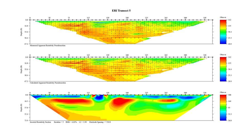
3 Page Introduction A geophysical investigation was conducted within accessible portions of the retention pond located at the Village Alhambra residential development in The Villages, Florida. Prior to this investigation, two dropouts occurred within the pond. This investigation was conducted on August 10 and 13, The purpose of the investigation was to help characterize near-surface geological conditions and to identify subsurface features that may be associated with sinkhole activity within the pond. The results of the investigation are shown on Figure 1. Site Geology In general, the near-surface sediments consist of undifferentiated clays associated with the Hawthorn Group in this region. These near-surface clayey soils are underlain by the Ocala Limestone. The Ocala Limestone is a highly transmissive carbonate unit very susceptible to sinkhole activity. The lithological contact between these two units is can be highly weathered and often exhibits significant variations in relief due to erosional and karst-related geological processes. 2.0 Description of Geophysical Investigation The ERI survey was conducted using the Advanced Geosciences, Inc. Sting R8 automatic electrode resistivity system. Ten ERI transects were performed using up to 49 electrodes with an a spacing of 7.5 ft. A dipole-dipole combined with an inverse Schlumberger electrode configuration was used with a maximum n value of six. The ERI data was analyzed using EarthImager 2D, a computer inversion program, which provides two-dimensional vertical cross-sectional resistivity model (pseudo-section) of the subsurface. The positions of the geophysical transect lines were recorded using a Trimble GeoXH Global Positioning System (GPS). A Wide Area Augmentation System (WAAS) was used to augment GPS with additional signals for increasing the reliability, integrity, accuracy and availability of the GPS signal. By using WAAS, an accuracy of less than 3 ft in the horizontal dimension was achieved. A description of the ERI method and the methods employed for geotechnical characterization studies is provided in Appendix A2.2. A discussion of the modeling process used to create the ERI results is provided in Appendix A2.2.1.
4 Page Identification of Possible Sinkhole Features Using ERI Method Sinkhole features are typically characterized by one of the following conditions on the ERI profile: 1. The occurrence of highly resistive material that extends to depth in a columnar fashion towards the top of the limestone. Such a feature may indicate the presence of a sand-filled depression or raveling zone. 2. The localized presence of low-resistivity material extending below the interpreted depth to the top of limestone. Such a feature may indicate the presence of a clay-filled void or fracture with the limestone or the presence of highly weathered limestone rock. 3. Any significant localized increase in the depth to limestone. Such a feature may indicate the presence of an in-filled depression (paleosink). When comparing the results of the ERI method, the following considerations should be given. The ERI method, for example, describes the transition from clay to limestone as a transition, rather than a discrete depth. This transition is due to several factors including: a) The vertical density of the resistivity data decreasing with depth and b) The possibility that the upper portion of the limestone is weathered which would create a physical transition zone in terms of resistivity between the clay and competent (non-weathered) limestone and c) The limitations in the modeling process. 4.0 Survey Results Results from the ERI survey are shown on Figure 1 and the individual data profiles are presented in Appendix 1. The ERI transects are of good quality (a discussion of the criteria used to determine the quality of an ERI inversion model is provided in Appendix A2.2.1). In general, analysis of the ERI transects indicate the presence of low to moderate resistivity near-surface soil materials to a depth range of approximately 5 to 10 ft bls (represented in blue to green on the ERI transects). This low to moderate resistivity layer is likely associated with the Hawthorn Group clayey soils. The majority of the surficial low to moderate resistivity layer is underlain by an approximately 5 to 30-ft thick high resistivity layer (represented in yellow to red) underlain by an approximately 20 to 40-ft thick low to moderate resistivity layer. This sequence is followed by a deeper high resistivity layer to the maximum
5 Page 3 depth of investigation of the ERI transects which ranged from approximately 43 to 82 ft bls. The lower sequence of high resistivity to low/moderate resistivity earth materials is most likely associated with variations in the Ocala Limestone Formation. Three ERI anomalies were identified at the project site (Figure 1). The anomalies are labeled 1 through 3 on Figure 1 and on the corresponding ERI transect profiles. The ERI anomalies were characterized by the apparent breach of the high resistivity stratum into the underlying soils. It is noted that the three ERI anomalies were observed in corresponding locations on the transects, and are likely associated with larger karst features as shown on the figure. ERI Anomaly 1 corresponds to the location of the two observed dropouts in the pond. However, despite this correlation it is not possible based on the geophysical results to determine whether these identified anomalies have a potential for further collapse or raveling. Table 1 provides the coordinates for the apparent centers for each ERI anomaly. These coordinates were developed using a Trimble GEO-XH global positioning system (GPS) with sub 3-foot accuracy. Table 1 ERI Anomaly Center Coordinates* Anomaly Northing Easting Latitude Longitude * US State Plane, Florida West 0101, NAD83 (Conus), Feet
6 APPENDIX 1 FIGURE AND ERI TRANSECTS
7
8 ERI Anomaly 3 ERI Anomaly 1
9 ERI Anomaly 1 ERI Anomaly 1
10 ERI Anomaly 2 ERI Anomaly 2
11 ERI Anomaly 3
12
13 A2-1 APPENDIX 2 DESCRIPTION OF GEOPHYSICAL METHODS, SURVEY METHODOLOGIES AND LIMITATIONS A2.1 On Site Measurements The positions of the geophysical transect lines were recorded using a Trimble GeoXH Global Positioning System (GPS). These GPS systems typically have an accuracy of 1 to 3 ft. A2.2 Electrical Resistivity Electrical resistivity surveying is a geophysical method in which an electrical current is injected into the earth; the subsequent response (potential) is measured at the ground surface to determine the resistance of the underlying earth materials. The resistivity survey is conducted by applying electrical current into the earth from two implanted electrodes (current electrodes C1 and C2) and measuring the associated potential between a second set of implanted electrodes (potential electrodes P1 and P2). Field readings are in volts. Field readings are then converted to resistivity values using Ohm s Law and a geometric correction factor for the spacing and configuration of the electrodes. The calculated resistivity values are known as apparent resistivity values. The values are referred to as apparent because the calculations for the values assume that the volume of earth material being measured is electrically homogeneous. Such field conditions are rarely present. Resistivity of earth materials is controlled by several properties including composition, water content, pore fluid resistivity and effective permeability. For this study the properties that had the primary control on measured resistivity values are composition and effective permeability. The general geological setting of this project area is clay overlain by limestone. For this study a dipole-dipole combined with an inverse Schlumberger resistivity array configuration was used. The dipole-dipole array is different that most other resistivity arrays in that the electrode and current electrodes are kept together using a constant spacing value referred to as an a spacing. The current and potential electrode sets are moved away from each other using multiples of the a spacing value. The number of multiples is referred to as the n value. For example, an array with an a spacing of 5 ft and a n value of 6 would have the current and potential electrode sets spaced 30 ft apart with a separation between the two electrodes in the set of 5 ft. By sampling at varying n values, greater depth measurements can be achieved. Inverse Schlumberger data is collected with the
14 A2-2 current set of electrodes being kept with a fixed separation (L spacing) and the potential electrodes a minimum distance of 5L from the inner current electrodes. Dipole-dipole resistivity data is usually presented in a two-dimensional pseudosection format. Inverse Schlumberger data is usually presented as a vertical profile of resistivity distribution below the center point between the two current electrodes. The dipole-dipole and inverse Schlumberger data is combined and presented as either a contour of the individual data points (using the calculated apparent resistivity values) or as a geological model using least squares analysis. Such least squares analysis was used for this study using the computer software program (EarthImager 2D) developed for the equipment manufacturer. Apparent resistivity values are calculated using the following formula for a dipole-dipole configuration: a= (b 3 /a 2 -b) V/I: Where: a= apparent resistivity = 3.14 a= a spacing b= a spacing x n value V= voltage between the two potential electrodes I= current (in amps) For a Schlumberger configuration the apparent resistivity is calculated using: a= ([s 2 -a 2 ]/4) V/aI: Where: a= apparent resistivity = 3.14 a= spacing between the inner set of electrodes s= distance between the outer electrode and nearest inner electrode V= voltage between the two potential electrodes I= current (in amps) A2.2.1 Inversion Modeling of ERI Data The objective for inversion modeling of resistivity data is to create a description of the actual distribution of earth material resistivity based on the subsurface geology that closely matches the resistivity values that are measured by the instrumentation. This modeling is done through the use of EarthImager TM, a proprietary computer program developed by the equipment manufacturer. When evaluating the validity of the inversion model several factors need to be considered. The RMS, or root mean square error, expresses the quality of fit
15 A2-3 between the actual and modeled resistivity values for the given set of points in the model. The lower the RMS error the higher the quality of fit between the actual and modeled data sets. In general, inversion models with an RMS error of less than 5 to 10 percent are acceptable. The size of the RMS error is dependent upon the number of bad data points within a data set and the magnitude of how bad the data points are. As part of the modeling process bad data points are typically removed, which decreases the RMS error and improves (with limitations) the quality of the model. The quality of fit between the actual and modeled resistivity values is also expressed as the L-2 norm. When the modeled and actual data sets have converged, the L-2 norm reduces to unity (1.0 or smaller). However, as the number of data points is reduced, the validity of the inversion model is diminished. Accordingly, when interpreting a particular area of an inversion model the number of data points used to create that portion of the model must be taken into consideration. If very few points are within a particular area of the model, then the modeled solution in that area should be considered suspect and possibly rejected. The entire ERI transect should be considered suspect if a model has a high RMS error and a large number of removed data points. It is likely that sources of interference have affected the field readings and rendered the modeled solution invalid. Such sources of interference can include buried metallic underground utilities, reinforced concrete slabs, septic leach fields or electrical grounding systems. Accordingly, all efforts need to be made in the field to locate, to the degree possible, the ERI transect lines away from such features. The locations of such features also need to be mapped in the field so their potential effects can be considered when interpreting the modeled results.
Sabal Trail Pipeline Project Evaluation of Karst Topography and Sinkhole Potential for Pipeline and Facilities
 November 11, 2014 Sabal Trail Pipeline Project Evaluation of Karst Topography and Sinkhole Potential for Pipeline and Facilities Gulf Interstate Engineering Attention: Mr. Denys Stavnychyi - Project Engineer
FINAL REPORT GEOPHYSICAL INVESTIGATION WATER TOWER NO. 6 SITE PLANT CITY, FL
 APPENDIX B FINAL REPORT GEOPHYSICAL INVESTIGATION WATER TOWER NO. 6 SITE PLANT CITY, FL Prepared for Madrid Engineering Group, Inc. Bartow, FL Prepared by GeoView, Inc. St. Petersburg, FL February 28,
Sabal Trail Pipeline Project Evaluation of Karst Topography and Sinkhole Potential for Pipeline and Facilities
 November 11, 2014 Sabal Trail Pipeline Project Evaluation of Karst Topography and Sinkhole Potential for Pipeline and Facilities Gulf Interstate Engineering Attention: Mr. Denys Stavnychyi - Project Engineer
IMAGING OF DEEP SINKHOLES USING THE MULTI-ELECTRODE RESISTIVITY IMPLANT TECHNIQUE (MERIT) CASE STUDIES IN FLORIDA
 CASE STUDIES IN FLORIDA") IMAGING OF DEEP SINKHOLES USING THE MULTI-ELECTRODE RESISTIVITY IMPLANT TECHNIQUE (MERIT) CASE STUDIES IN FLORIDA David Harro The G3 Group, 2509 Success Drive, Suite 1, Odessa, FL 33556, david.harro@geo3group.com
IMAGING OF DEEP SINKHOLES USING THE MULTI-ELECTRODE RESISTIVITY IMPLANT TECHNIQUE (MERIT) CASE STUDIES IN FLORIDA David Harro The G3 Group, 2509 Success Drive, Suite 1, Odessa, FL 33556, david.harro@geo3group.com
M E M O R A N D U M. Mr. Jonathan K. Thrasher, P.E. and Mr. Ian Kinnear, P.E. PSI
 M E M O R A N D U M TO: FROM: Mr. Mark Schilling Gulf Interstate Engineering Mr. Jonathan K. Thrasher, P.E. and Mr. Ian Kinnear, P.E. PSI DATE: November 11, 2014 RE: Summary of Findings Geotechnical Study
KARST MAPPING WITH GEOPHYSICS AT MYSTERY CAVE STATE PARK, MINNESOTA
 KARST MAPPING WITH GEOPHYSICS AT MYSTERY CAVE STATE PARK, MINNESOTA By Todd A. Petersen and James A. Berg Geophysics Program Ground Water and Climatology Section DNR Waters June 2001 1.0 Summary A new
REPORT OF GEOPHYSICAL SURVEY
 REPORT OF GEOPHYSICAL SURVEY KARST IMAGING STUDY CADIZ INDUSTRIAL PARK CADIZ, TRIGG COUNTY, KY MUNDELL PROJECT NO. M NOVEMBER, South Downey Avenue, Indianapolis, Indiana - Telephone --, Facsimile -- www.mundellassociates.com
 SHEET TITLE: DRAWN BY: J.M.CLARK FILE NO. CHECKED BY: W.S. JORDAN APPROVED BY: DATE: FIGURE SHEET TITLE: DRAWN BY: J.M.CLARK FILE NO. CHECKED BY: W.S. JORDAN APPROVED BY: DATE: FIGURE SPOTLIGHT Technical
BUFFALO RIVER COALITION PO Box 101, Jasper, AR (870)
") BUFFALO RIVER COALITION PO Box 101, Jasper, AR 72641 (870) 446-5783 buffalowatershed@gmail.com Presentation before Arkansas Pollution Control and Ecology Commission, April 29, 2016 by Richard Mays on behalf
BUFFALO RIVER COALITION PO Box 101, Jasper, AR 72641 (870) 446-5783 buffalowatershed@gmail.com Presentation before Arkansas Pollution Control and Ecology Commission, April 29, 2016 by Richard Mays on behalf
CONTENTS 1. INTRODUCTION. 2. THE D.C. RESISTIVITY METHOD 2.1 Equipment 2.2 Survey Procedure 2.3 Data Reduction
 (i) CONTENTS 1. INTRODUCTION page 1 2. THE D.C. RESISTIVITY METHOD 2.1 Equipment 2.2 Survey Procedure 2.3 Data Reduction 3 3 3 3 3. GEOPHYSICAL RESULTS 3.1 General 3.2 Discussion 4 4 4 4. LIMITATIONS 5
LIST OF FIGURES APPENDICES
 RESISTIVITY / INDUCED POLARIZATION SURVEY EL PORVENIR PROJECT MUNICIPALITY OF REMEDIOS, ANTIOQUIA, COLOMBIA LOGISTICS REPORT M-17427 APRIL 2017 TABLE OF CONTENTS Abstract... 1 1. The Mandate... 2 2. El
Geophysical Methods for Screening and Investigating Utility Waste Landfill Sites in Karst Terrain
 Geophysical Methods for Screening and Investigating Utility Waste Landfill Sites in Karst Terrain Gary Pendergrass, PE, RG, F.NSPE Principal Geological Engineer Kansas City Geotechnical Conference 2017
Florida s Karst Geology
 Florida s Karst Geology Orange Creek Basin Interagency Working Group Public Workshop, November 5 th, 2015 Harley Means, P.G. Assistant State Geologist Florida Geological Survey Karst Karst a type of topography
A GPR ASSESSMENT OF THE PREHISTORIC NAPLES CANAL NAPLES, FLORIDA ARCHAEOLOGICAL AND HISTORICAL CONSERVANCY, INC.
 A GPR ASSESSMENT OF THE PREHISTORIC NAPLES CANAL NAPLES, FLORIDA ARCHAEOLOGICAL AND HISTORICAL CONSERVANCY, INC. AHC TECNICAL REPORT NO. 1004 DECEMBER 2013 A GPR ASSESSMENT OF THE PREHISTORIC NAPLES CANAL
Applied Geophysics for Environmental Site Characterization and Remediation
 Applied Geophysics for Environmental Site Characterization and Remediation MSECA Webinar September 24, 2015 John Mundell, P.E., L.P.G. Ryan Brumbaugh, L.P.G. MUNDELL & ASSOCIATES, INC. Webinar Objective
CHARACTERIZATION OF SOIL PROFILE OF DHAKA CITY USING ELECTRICAL RESISTIVITY TOMOGRAPHY (ERT)
") CHARACTERIZATION OF SOIL PROFILE OF DHAKA CITY USING ELECTRICAL RESISTIVITY TOMOGRAPHY (ERT) Mehedi Ahmed ANSARY 1, B.S. Pushpendue BISWAS 2 and Abul KHAIR 3 1 Professor, Department of Civil Engineering
CHARACTERIZATION OF SOIL PROFILE OF DHAKA CITY USING ELECTRICAL RESISTIVITY TOMOGRAPHY (ERT) Mehedi Ahmed ANSARY 1, B.S. Pushpendue BISWAS 2 and Abul KHAIR 3 1 Professor, Department of Civil Engineering
ELECTRICAL RESISTIVITY SURVEYS AT THE ANDERSON RESIDENCE SITE, PORT CLYDE, ME. For: St.Germain-Collins
 ELECTRICAL RESISTIVITY SURVEYS AT THE ANDERSON RESIDENCE SITE, PORT CLYDE, ME For: St.Germain-Collins 4 Union Street, Suite 3 Bangor, Maine 441 July, 218 ELECTRICAL RESISTIVITY SURVEYS AT THE ANDERSON
2-D Resistivity Study: The Horizontal Resolution Improvement by Introducing the Enhancing Horizontal Resolution (EHR) Technique
 Technique") Open Journal of Geology, 213, 3, 1-6 doi:1.4236/ojg.213.32b1 Published Online April 213 (http://www.scirp.org/journal/ojg) 2-D Resistivity Study: The Horizontal Resolution Improvement by Introducing the
Open Journal of Geology, 213, 3, 1-6 doi:1.4236/ojg.213.32b1 Published Online April 213 (http://www.scirp.org/journal/ojg) 2-D Resistivity Study: The Horizontal Resolution Improvement by Introducing the
The Efficacy of Enhancing Horizontal Resolution (EHR) Technique in Shallow Subsurface Study Using 2D Resistivity Method at Bukit Bunuh
 Technique in Shallow Subsurface Study Using 2D Resistivity Method at Bukit Bunuh") 212 International Conference on Geological and Environmental Sciences IPCBEE vol.3 6(212) (212)IACSIT Press, Singapoore The Efficacy of Enhancing Horizontal Resolution (EHR) Technique in Shallow Subsurface
212 International Conference on Geological and Environmental Sciences IPCBEE vol.3 6(212) (212)IACSIT Press, Singapoore The Efficacy of Enhancing Horizontal Resolution (EHR) Technique in Shallow Subsurface
GEOPHYSICAL IMAGING TO ENHANCE ANALYSIS, DESIGN AND DRILLING OF LARGE-SCALE GEOTHERMAL SYSTEMS. Abstract
 GEOPHYSICAL IMAGING TO ENHANCE ANALYSIS, DESIGN AND DRILLING OF LARGE-SCALE GEOTHERMAL SYSTEMS John A. Mundell, Mundell & Associates, Inc., Indianapolis, Indiana Gabriel Hebert, Mundell & Associates, Inc.,
MOUNT POLLEY MINING CORPORATION TECHNICAL REPORT ON MULTI-ELECTRODE RESISTIVITY AND SEISMIC REFRACTION SURVEYS MOUNT POLLEY TAILINGS DAM PROJECT
 MOUNT PLEY MINING CORPORATION TECHNICAL REPORT ON MULTI-ELECTRODE RESISTIVITY AND SEISMIC REFRACTION SURVEYS MOUNT PLEY TAILINGS DAM PROJECT LIKELY, B.C. by Claudia Krumbiegel, M.Sc. Cliff Candy, P.Geo.
M E M O R A N D U M. Mr. Jonathan K. Thrasher, P.E., Mr. Ian Kinnear, P.E. (FL) PSI
 PSI") M E M O R A N D U M TO: FROM: Mr. Mark Schilling Gulf Interstate Engineering Mr. Jonathan K. Thrasher, P.E., Mr. Ian Kinnear, P.E. (FL) PSI DATE: November 11, 2014 RE: Summary of Findings Geotechnical
M E M O R A N D U M TO: FROM: Mr. Mark Schilling Gulf Interstate Engineering Mr. Jonathan K. Thrasher, P.E., Mr. Ian Kinnear, P.E. (FL) PSI DATE: November 11, 2014 RE: Summary of Findings Geotechnical
A Case Study of High-Resolution Gravity and Wenner-Schlumberger Resistivity for Geotechnical Engineering: An Example from North Jordan
 Research Journal of Applied Sciences, Engineering and Technology 5(4): 1377-1382-, 2013 ISSN: 2040-7459; e-issn: 2040-7467 Maxwell Scientific Organization, 2013 Submitted: July 09, 2012 Accepted: August
ELECTRICAL RESISTIVITY SURVEY OF INTREPID POTASH INJECTION WELL SITE: EDDY COUNTY, NEW MEXICO
 NCKRI REPORT OF INVESTIGATION 3 ELECTRICAL RESISTIVITY SURVEY OF INTREPID POTASH INJECTION WELL SITE: EDDY COUNTY, NEW MEXICO www.nckri.org NATIONAL CAVE AND KARST RESEARCH INSTITUTE REPORT OF INVESTIGATION
Lima Project: Seismic Refraction and Resistivity Survey. Alten du Plessis Global Geophysical
 Lima Project: Seismic Refraction and Resistivity Survey Alten du Plessis Global Geophysical Report no 0706/2006 18 December 2006 Lima Project: Seismic Refraction and Resistivity Survey by Alten du Plessis
Development of geophysical investigation for verifying treatment efficiency of underground cavities
 Development of geophysical investigation for verifying treatment efficiency of underground cavities Hasan A. Kamal* Kuwait Institute for Scientific Research, Infrastructure Risk and Reliability Program,
USE OF GEOPHYSICAL SURVEYS FOR FILL CHARACTERIZATION AND QUANTITY ESTIMATION AT BROWNFIELD SITES A CASE HISTORY. Abstract
 USE OF GEOPHYSICAL SURVEYS FOR FILL CHARACTERIZATION AND QUANTITY ESTIMATION AT BROWNFIELD SITES A CASE HISTORY John A. Mundell, Mundell & Associates, Inc., Indianapolis, IN Gregory B. Byer, Mundell &
Geophysical Exploration in Water Resources Assessment. John Mundell, P.E., L.P.G., P.G. Ryan Brumbaugh, L.P.G. Mundell & Associates, Inc.
 Geophysical Exploration in Water Resources Assessment John Mundell, P.E., L.P.G., P.G. Ryan Brumbaugh, L.P.G. Mundell & Associates, Inc. Presentation Objective Introduce the use of geophysical survey methods
High Resolution Time-domain Induced Polarization Tomography with Merging Data Levels by Two Different Optimized Arrays for Slope Monitoring Study
 High Resolution Time-domain Induced Polarization Tomography with Merging Data Levels by Two Different Optimized Arrays for Slope Monitoring Study Andy A. Bery Geophysics Section, School of Physics, Universiti
Exploration and Optimized Extraction of Retained Gold Inventory in Heap Leach Stacks Prior to Closure
 Abstract Exploration and Optimized Extraction of Retained Gold Inventory in Heap Leach Stacks Prior to Closure J. B. Fink. Ph.D., P.E., and R. S. Bell, hydrogeophysics, Inc. Thom Seal, P.E., Ph.D., Newmont
Geophysics for Environmental and Geotechnical Applications
 Geophysics for Environmental and Geotechnical Applications Dr. Katherine Grote University of Wisconsin Eau Claire Why Use Geophysics? Improve the quality of site characterization (higher resolution and
Electrical prospecting involves detection of surface effects produced by electrical current flow in the ground.
 Electrical Surveys in Geophysics Electrical prospecting involves detection of surface effects produced by electrical current flow in the ground. Electrical resistivity method Induced polarization (IP)
ELECTRICAL RESISTIVITY TOMOGRAPHY
 NOTIO Association Clay Technological Centre C/ Río Cabriel s/n 45007 Toledo Tel.: 925 24 11 62 info@notio.es www.notio.es Page 1 / 7 SUMMARY 1. PHYSICAL FUNDAMENTALS OF THE... 3 1.1. ELECTRICAL BEHAVIOR
Ardaman & Associates, Inc. Geotechnical, Environmental and Materials Consultants
 SUBSURFACE SOIL EXPLORATION 42-INCH FORCE MAIN REPLACEMENT CHIQUITA BOULEVARD S AND SW 34 TH STREET CAPE CORAL, LEE COUNTY, FLORIDA Ardaman & Associates, Inc. Geotechnical, Environmental and Materials
STATISTICAL ANALYSIS OF GPR AND SPT METHODS FOR SINKHOLE INVESTIGATION IN COVERED KARST TERRAIN, WEST-CENTRAL FLORIDA, USA
 STATISTICAL ANALYSIS OF GPR AND SPT METHODS FOR SINKHOLE INVESTIGATION IN COVERED KARST TERRAIN, WEST-CENTRAL FLORIDA, USA Henok Kiflu, Sarah Kruse Dept. of Geology, University of South Florida, 4202 E.
GEOSYNTEC CONSULTANTS
 GEOSYNTEC CONSULTANTS 2100 Main Street, Suite 150 Huntington Beach, CA 92648 USA Tel (714) 969-0800 Fax (714) 969-0820 15 February 2006 Ms. Tamara Zeier, P.E. Project Manager Project Navigator, Ltd. One
Appendix B: Geophysical Data (Thesis Appendix, 2013)
") Utah State University From the SelectedWorks of David J Richey 2013 Appendix B: Geophysical Data (Thesis Appendix, 2013) David J Richey, Utah State University Available at: https://works.bepress.com/david_richey/2/
Utah State University From the SelectedWorks of David J Richey 2013 Appendix B: Geophysical Data (Thesis Appendix, 2013) David J Richey, Utah State University Available at: https://works.bepress.com/david_richey/2/
Geophysical Study of Limestone Attributes At Abudu Area of Edo State, Nigeria
 Journal of Emerging Trends in Engineering and Applied Sciences (JETEAS) 2 (5): 795-800 Scholarlink Research Institute Journals, 2011 (ISSN: 2141-7016) jeteas.scholarlinkresearch.org Journal of Emerging
Geophysical Investigation: A Case Study of Basement Complex, Nigeria
 Geophysical Investigation: A Case Study of Basement Complex, Nigeria Adiela U.P 1, Ayodele Moses Oyewole 2 and Omoirabor Omoleomo 3 1 Department of Petroleum Engineering, Nigerian Agip Oil Company, Port
Roy Pyle March 24, 2017 Chief Facilities Planner Contra Costa Community College District 500 North Court Street Martinez, CA 94533
 State of California Natural Resources Agency Edmund G. Brown Jr., Governor Department of Conservation John G. Parrish, Ph.D., State Geologist California Geological Survey 801 K Street MS 12-31 Sacramento,
OWNER OPERATOR: BLACKWATER EXPLORATIONS LTD. REPORT ON RESISTIVITY PROFILING SURVEY PLACER GOLD EXPLORATION
 OWNER OPERATOR: BLACKWATER EXPLORATIONS LTD. REPORT ON RESISTIVITY PROFILING SURVEY PLACER GOLD EXPLORATION CARIBOO MINING DISTRICT NTS 93G CLAIM PC682023 Latitude 53 13 35.64 Longitude 122 49 40.65 by
Subsurface Characterization using Electrical Resistivity(Dipole-Dipole) method at Lagos State University (LASU) Foundation School, Badagry
 method at Lagos State University (LASU) Foundation School, Badagry") Available online at www.pelagiaresearchlibrary.com Advances in Applied Science Research, 2010, 1 (1): 174-181 Subsurface Characterization using Electrical Resistivity(Dipole-Dipole) method at Lagos State
Available online at www.pelagiaresearchlibrary.com Advances in Applied Science Research, 2010, 1 (1): 174-181 Subsurface Characterization using Electrical Resistivity(Dipole-Dipole) method at Lagos State
UTC R189 GEOPHYSICAL ASSESSMENT OF KARST ACTIVITY. Neil L. Anderson
 GEOPHYSICAL ASSESSMENT OF KARST ACTIVITY by Neil L. Anderson UTC R189 A University Transportation Center Program at Missouri University of Science & Technology Disclaimer The contents of this report reflect
Engineering Geophysical Application to Mine Subsidence Risk Assessment
 Engineering Geophysical Application to Mine Subsidence Risk Assessment By: Kanaan Hanna, Sr. Mining Engineer Steve Hodges, Sr. Geophysicist Jim Pfeiffer, Sr. Geophysicist Dr. Keith Heasley, Professor West
Geophysical Assessment of Subsurface Soil Conditions Using Capacitively Coupled Resistivity
 University of Arkansas, Fayetteville ScholarWorks@UARK Theses and Dissertations 8-2018 Geophysical Assessment of Subsurface Soil Conditions Using Capacitively Coupled Resistivity Folaseye Coker University
A GPR ASSESSMENT OF THE NAPLES CANAL 8CR59: PHASE II NAPLES, FLORIDA ARCHAEOLOGICAL AND HISTORICAL CONSERVANCY, INC.
 A GPR ASSESSMENT OF THE NAPLES CANAL 8CR59: PHASE II NAPLES, FLORIDA ARCHAEOLOGICAL AND HISTORICAL CONSERVANCY, INC. AHC TECNICAL REPORT NO. 1023 JUNE 2014 A GPR ASSESSMENT OF THE NAPLES CANAL 8CR59: PHASE
Slope Stability Evaluation Ground Anchor Construction Area White Point Landslide San Pedro District Los Angeles, California.
 Slope Stability Evaluation Ground Anchor Construction Area White Point Landslide San Pedro District Los Angeles, California Submitted To: Mr. Gene Edwards City of Los Angeles Department of Public Works
The three-year mapping and monitoring of underground cavity expansion with 2D resistivity survey: What has revealed?
 The three-year mapping and monitoring of underground cavity expansion with 2D resistivity survey: What has revealed? Peangta Satarugsa 1, Winit Youngmee 1 and Suvijuk Meesawat 1 1. Department of Geotechnology,
Comparison of an optimized resistivity array with dipole-dipole soundings in karst terrain
 GEOPHYSICS, VOL. 7, NO. JULY-AUGUST 7 ; P. F19 F1, 8 FIGS. 1.119/1.799 Comparison of an optimized resistivity array with dipole-dipole soundings in karst terrain Jonathan E. Nyquist 1, John S. Peake, and
NUTC R367. Assessment of Active Karst Features in Proximity to Paved Roadways
 Assessment of Active Karst Features in Proximity to Paved Roadways by Neil Anderson NUTC R367 A National University Transportation Center at Missouri University of Science and Technology Disclaimer The
APPLICATION OF RESISTIVITY SURVEY TO INVESTIGATE SINKHOLE AND KARST FEATURES IN SOUTHERN THAILAND : A CASE STUDY OF PAKJAM AREA
 GEOTHAI 07 International Conference on Geology of Thailand: Towards Sustainable Development and Sufficiency Economy APPLICATION OF RESISTIVITY SURVEY TO INVESTIGATE SINKHOLE AND KARST FEATURES IN SOUTHERN
Geophysical Investigation of Foundation Condition of A Site in Ikere- Ekiti, Ekiti State, South-Western Nigeria
 Australian Journal of Basic and Applied Sciences, 5(9): 1852-1857, 2011 ISSN 1991-8178 Geophysical Investigation of Foundation Condition of A Site in Ikere- Ekiti, Ekiti State, South-Western Nigeria 1
The Preliminary Study of Meteorite Impact Crater at Bukit Bunuh, Lenggong
 2012 International Conference on Geological and Environmental Sciences IPCBEE vol.3 6(2012) (2012)IACSIT Press, Singapoore The Preliminary Study of Meteorite Impact Crater at Bukit Bunuh, Lenggong A. H.
UTC R161. Geotechnical Site Characterization of Transportation Construction Sites and Structures. Neil L. Anderson. Derek B. Apel.
 Geotechnical Site Characterization of Transportation Construction Sites and Structures Assessment Of Karst Activity At Highway Construction Sites In Greene And Jefferson Counties, Missouri, Using The Electrical
Although most karstic regions
 Urban Geophysics: Geophysical Signature of Mount Bonnell Fault and Its Karstic Features in Austin, TX by Mustafa Saribudak, Environmental Geophysics Associates, Austin, TX Although most karstic regions
We 21 C15 Geophysical Investigation for an Assessment of Sinkhole Risk in Schleswig-Holstein/Northern Germany
 We 21 C15 Geophysical Investigation for an Assessment of Sinkhole Risk in Schleswig-Holstein/Northern Germany R. Kirsch* (LLUR-SH), H. Wiederhold (LIAG), W. Rabbel (CAU), E. Erkul (CAU), C. Thomsen (LLUR-SH),
APPLICATION OF ELECTRICAL RESISTIVITY TOMOGRAPHY FOR SAND UNDERWATER EXTRACTION
 International Scientific Conference GEOBALCANICA 2018 APPLICATION OF ELECTRICAL RESISTIVITY TOMOGRAPHY FOR SAND UNDERWATER EXTRACTION Maya Grigorova Ivaylo Koprev University of Mining and Geology St. Ivan
GEOPHYSICAL SITE CHARACTERIZATION IN SUPPORT OF HIGHWAY EXPANSION PROJECT
 GEOPHYSICAL SITE CHARACTERIZATION IN SUPPORT OF HIGHWAY EXPANSION PROJECT * Shane Hickman, * Todd Lippincott, * Steve Cardimona, * Neil Anderson, and + Tim Newton * The University of Missouri-Rolla Department
INVITATION TO BID CITY OF CAPE CORAL SW 6&7 UTILITIES EXTENSION PROJECT CONTRACT VII CENTRAL AREA 6 AND CENTRAL AREA 8 ITB UT13-02/TM-G
 GEOTECHNICAL REPORT INVITATION TO BID CITY OF CAPE CORAL SW 6&7 UTILITIES EXTENSION PROJECT CONTRACT VII CENTRAL AREA 6 AND CENTRAL AREA 8 ITB UT13-02/TM-G City of Cape Coral Procurement Division 1015
Geophysical Investigation of Ground Water Using Vertical Electrical Sounding and Seismic Refraction Methods
 International Journal of Petroleum and Petrochemical Engineering (IJPPE) Volume 2, Issue 1, 2016, PP 6-11 ISSN 2454-7980 (Online) www.arcjournals.org Geophysical Investigation of Ground Water Using Vertical
Scholars Research Library
 Available online at www.scholarsresearchlibrary.com Scholars Research Library Archives of Physics Research, 2010, 1 (2):37-45 (http://scholarsresearchlibrary.com/archive.html) ISSN 0976-0970 2-D Resistivity
Geoelectricity. ieso 2010
 Geoelectricity ieso 2010 1 RESISTIVITY SURVEY AT VENETO VILLA GRITTI AT THE TOWN OF TREVISO (VENETO REGION) The survey was carried out to verify the underground presence of the fondations of a rustic building.
Geology and Soils. Technical Memorandum
 Geology and Soils Technical Memorandum TO: FDOT FROM: HDR, Inc. DATE: February 2013 PROJECT: St Johns River Crossing FPID No: 208225-3-21-01 Clay, Duval, and St. Johns Counties; Florida Geology and soils
Geophysics Course Introduction to DC Resistivity
 NORAD supported project in MRRD covering Capacity Building and Institutional Cooperation in the field of Hydrogeology for Faryab Province Afghanistan Geophysics Course Introduction to DC Resistivity By
LECTURE 10. Module 3 : Field Tests in Rock 3.6 GEOPHYSICAL INVESTIGATION
 LECTURE 10 3.6 GEOPHYSICAL INVESTIGATION In geophysical methods of site investigation, the application of the principles of physics are used to the study of the ground. The soil/rock have different characteristics
Beyond Rippability A Case History Integrating Seismic Refraction, Electrical Resistivity Imaging, and Geotechnical Boring Logs
 Beyond Rippability A Case History Integrating Seismic Refraction, Electrical Resistivity Imaging, and Geotechnical Boring Logs Jonathan B. Shawver 1 (jb@geovision.com), William Dalrymple 1 (will@geovision.com),
Groundwater Assessment in Apapa Coast-Line Area of Lagos Using Electrical Resistivity Method
 Journal of Emerging Trends in Engineering and Applied Sciences (JETEAS) 2 (4): 673-679 Scholarlink Research Institute Journals, 2011 (ISSN: 2141-7016) jeteas.scholarlinkresearch.org Groundwater Assessment
Taseko Prosperity Gold-Copper Project. Appendix 3-6-Q
 Taseko Prosperity Gold-Copper Project Appendix 3-6-Q KNIGHT & PIESOLD LTD. AND TASEKO MINES LIMITED REPORT ON SEISMIC REFRACTION AND REFLECTION INVESTIGATION PROSPERITY PROJECT, FISH LAKE AREA WILLIAMS
ELECTRICAL IMAGING OF A TRIASSIC FAULT SYSTEM IN NORTHERN NEW JERSEY. Abstract
 ELECTRICAL IMAGING OF A TRIASSIC FAULT SYSTEM IN NORTHERN NEW JERSEY Peter J. Hutchinson, The Hutchinson Group, Ltd., Murrysville, PA Jeffrey M. Dereume, Indiana University of Pennsylvania, Indiana, PA
Preliminary Geotechnical Investigation Cadiz / Trigg County I-24 Business Park. Cadiz, Kentucky
 Environmental & Geoscience, LLC 834 Madisonville Road Hopkinsville, KY 440 70.44.000 FAX 70.44.8300 www.wedrill.com A member of Trinity Energy & Infrastructure Group, LLC Preliminary Geotechnical Investigation
Preliminary soil survey of the NATL Old Field Plots
 Preliminary soil survey of the NATL Old Field Plots The preliminary soil survey consisted of completing auger borings at 25 m intervals and included auger borings at total of 46 points. The borings were
Integration of Seismic Refraction and 2D Electrical Resistivity in Locating Geological Contact
 Open Journal of Geology, 2013, 3, 7-12 doi:10.4236/ojg.2013.32b002 Published Online April 2013 (http://www.scirp.org/journal/ojg) Integration of Seismic Refraction and 2D Electrical Resistivity in Locating
KANSAS GEOLOGICAL SURVEY Open File Report LAND SUBSIDENCE KIOWA COUNTY, KANSAS. May 2, 2007
 KANSAS GEOLOGICAL SURVEY Open File Report 2007-22 LAND SUBSIDENCE KIOWA COUNTY, KANSAS Prepared by Michael T. Dealy L.G., Manager, Wichita Operations SITE LOCATION The site was approximately four miles
Analysis of electrical resistivity data for the determination of aquifer depth at Sapele RD in Benin city
 Available online at www.pelagiaresearchlibrary.com Advances in Applied Science Research, 203, 4(6):268-276 ISSN: 0976-860 CODEN (USA): AASRFC Analysis of electrical resistivity data for the determination
September 21, 2004 GeoInsight Project
 GeoInsight, Inc. GeoInsight, Inc. GeoInsight, Inc. 75 Gilcreast Road, Suite 210 319 Littleton Road, Suite 105 Corporate Ten Center Londonderry, NH 03053-3566 Westford, MA 01886 1781 Highland Avenue, Suite
Shallow Karst Aquifer System of the Lake Belt Study Area, Miami-Dade County, Florida, USA EXTENDED ABSTRACT
 Second International Conference on Saltwater Intrusion and Coastal Aquifers Monitoring, Modeling, and Management. Merida, Mexico, March 30 April 2, 2003 Shallow Karst Aquifer System of the Lake Belt Study
ACCURATE SUBSURFACE CHARACTERIZATION FOR HIGHWAY APPLICATIONS USING RESISTIVITY INVERSION METHODS
 ACCURATE SUBSURFACE CHARACTERIZATION FOR HIGHWAY APPLICATIONS USING RESISTIVITY INVERSION METHODS Ioannis F. Louis 1, Filippos I. Louis 2 and Melanie Bastou 3 1 Geophysics & Geothermic Division, Geology
Geology 228/378 Applied and Environmental Geophysics Lecture 6. DC resistivity Surveys
 Geology 228/378 Applied and Environmental Geophysics Lecture 6 DC resistivity Surveys Direct current (DC) Resistivity. Introduction 2. Current flow in the ground 3. Schlumberger, Wenner, dipole-dipole,
Geophysical Survey of Wisconsin Burial Site BRO-0033 Wixom Cemetery, Rock County, Wisconsin
 Lawrence University Lux Archaeological Reports Anthropology Department 6-2015 Geophysical Survey of Wisconsin Burial Site BRO-0033 Wixom Cemetery, Rock County, Wisconsin Peter N. Peregrine Lawrence University
EXTREMELY FAST IP USED TO DELINEATE BURIED LANDFILLS. Norman R. Carlson, Cris Mauldin Mayerle, and Kenneth L. Zonge
 EXTREMELY FAST IP USED TO DELINEATE BURIED LANDFILLS Norman R. Carlson, Cris Mauldin Mayerle, and Kenneth L. Zonge Zonge Engineering and Research Organization, Inc. 3322 East Fort Lowell Road Tucson, Arizona,
1. Resistivity of rocks
 RESISTIVITY 1) Resistivity of rocks 2) General principles of resistivity surveying 3) Field procedures, interpretation and examples 4) Summary and conclusions INDUCED POLARIZATION 1) General principles
Environmental and Exploration Geophysics I. Resistivity II tom.h.wilson
 Environmental and Exploration Geophysics I Resistivity II tom.h.wilson tom.wilson@mail.wvu.edu Department of Geology and Geography West irginia University Morgantown, W Objectives for the day Review basic
Central Florida Sinkhole Evaluation
 Central Florida Sinkhole Evaluation By Kathy M. Gray 1 Abstract: This paper presents a discussion of sinkhole risk evaluation in Central Florida. It is the culmination of more than 33 years of practice
High Resolution Geophysics: A Better View of the Subsurface. By John Jansen, P.G., Ph.D., Aquifer Science and Technology
 High Resolution Geophysics: A Better View of the Subsurface By John Jansen, P.G., Ph.D., Aquifer Science and Technology Geologist Use Only Part of the Information Available To Them Most Geologist rely
Evaluation of Subsurface Formation of Pabna District, Bangladesh
 IOSR Journal of Applied Geology and Geophysics (IOSR-JAGG) e-issn: 2321 0990, p-issn: 2321 0982.Volume 1, Issue 4 (Sep. Oct. 2013), PP 30-36 Evaluation of Subsurface Formation of Pabna District, Bangladesh
PROCEEDING, SEMINAR NASIONAL KEBUMIAN KE-8 Academia-Industry Linkage OKTOBER 2015; GRHA SABHA PRAMANA
 INCORPORATION OF ELECTRICAL RESISTIVITY TOMOGRAPHY (ERT) DATA IN GEOLOGICAL MODELLING AS METHOD TO INCREASE MODEL ACCURACY IN UNSERPENTINISED ULTRAMAFIC HOSTED NICKEL LATERITE DEPOSIT Budhi Kumarawarman
Finding Large Capacity Groundwater Supplies for Irrigation
 Finding Large Capacity Groundwater Supplies for Irrigation December 14, 2012 Presented by: Michael L. Chapman, Jr., PG Irrigation Well Site Evaluation Background Investigation Identify Hydrogeologic Conditions
4.6 DC resistivity and IP field systems, data processing and interpretation
 4.6 DC resistivity and P field systems, data processing and interpretation Electrode arrays Response of a layered earth The anisotropic half space Response of simple inhomogeneities Solutions for arbitrary
RESISTIVITY IMAGING IN EASTERN NEVADA USING THE AUDIOMAGNETOTELLURIC METHOD FOR HYDROGEOLOGIC FRAMEWORK STUDIES. Abstract.
 RESISTIVITY IMAGING IN EASTERN NEVADA USING THE AUDIOMAGNETOTELLURIC METHOD FOR HYDROGEOLOGIC FRAMEWORK STUDIES Darcy K. McPhee, U.S. Geological Survey, Menlo Park, CA Louise Pellerin, Green Engineering,
Geotechnical Data Report
 Geotechnical Data Report Downtown Greenville Future Conveyance Study December 1, 2015 Terracon Project No. 86155032 Prepared for: Prepared by: Terracon Consultants, Inc. December 1, 2015 561 Mauldin Road
INVESTIGATIONS OF LARGE SCALE SINKHOLE COLLAPSES, LAIBIN, GUANGXI, CHINA
 INVESTIGATIONS OF LARGE SCALE SINKHOLE COLLAPSES, LAIBIN, GUANGXI, CHINA Yongli Gao Department of Geological Sciences, Center for Water Research, University of Texas at San Antonio, TX 78249, USA, yongli.gao@utsa.edu
Geology 103 Planet Earth (QR II), Laboratory Exercises 1. Groundwater
, Laboratory Exercises 1. Groundwater") Geology 103 Planet Earth (QR II), Laboratory Exercises 1 Student Name: Section: Karst Landform: Groundwater Anyone who has viewed Chinese landscape scroll paintings will recognize that the mountains are
Geology 103 Planet Earth (QR II), Laboratory Exercises 1 Student Name: Section: Karst Landform: Groundwater Anyone who has viewed Chinese landscape scroll paintings will recognize that the mountains are
AWRA PMAS Engineers Club of Philadelphia. A Geologic Perspective on Stormwater
 AWRA PMAS Engineers Club of Philadelphia A Geologic Perspective on Stormwater Toby J. Kessler, P.G. Hydrogeologist Trevor G. Woodward, P.G. Engineering Geologist September 10, 2014 Gilmore & Associates,
J.H. Campbell Generating Facility Pond A - Location Restriction Certification Report
 J.H. Campbell Generating Facility Pond A - Location Restriction Certification Report Pursuant to: 40 CFR 257.60 40 CFR 257.61 40 CFR 257.62 40 CFR 257.63 40 CFR 257.64 Submitted to: Consumers Energy Company
GM 1.4. SEG/Houston 2005 Annual Meeting 639
 storage recovery project in Leyden, Colorado Kristofer Davis *, Yaoguo Li, Michael Batzle, and Bob Raynolds** Center for Gravity, Electrical, and Magnetic Studies, Department of Geophysics, Colorado School
APPENDIX A: Magnetotelluric Data in Relation to San Pedro Mesa Structural. The San Pedro Mesa structural high (discussed in main text of paper) was
 was") Page of DR for GSA Special Paper 9, Chapter, Geophysical constraints APPENDIX A: Magnetotelluric Data in Relation to San Pedro Mesa Structural High The San Pedro Mesa structural high (discussed in main
Page of DR for GSA Special Paper 9, Chapter, Geophysical constraints APPENDIX A: Magnetotelluric Data in Relation to San Pedro Mesa Structural High The San Pedro Mesa structural high (discussed in main
Gravimetry Applied to Water Resources and Risk Management in Karst Areas: A Case Study in Paraná State, Brazil
 Gravimetry Applied to Water Resources and Risk Management in Karst Areas: A Case Study in Paraná State, Jair Silveira da SILVA JUNIOR, Francisco José FONSECA FERREIRA, Key words: gravimetry, resistivity,
CCR Rule Compliance: Innovative Use of Geophysics to Certify Landfill Stability and Site Groundwater Monitoring Wells
 CCR Rule Compliance: Innovative Use of Geophysics to Certify Landfill Stability and Site Groundwater Monitoring Wells Gary Pendergrass, PE, RG Principal Geological Engineer Missouri Waste Control Coalition
Case Study: University of Connecticut (UConn) Landfill
 Landfill") Case Study: University of Connecticut (UConn) Landfill Problem Statement:» Locate disposal trenches» Identify geologic features and distinguish them from leachate and locate preferential pathways in fractured
Case Study: University of Connecticut (UConn) Landfill Problem Statement:» Locate disposal trenches» Identify geologic features and distinguish them from leachate and locate preferential pathways in fractured
A REPORT. Bear Lake, British Columbia (56' 13'N, ~) N.T.S. 94 D U& Claims surveyed: BL 1, units 2
 N.T.S. 94 D U& Claims surveyed: BL 1, units 2") I PETER E. WALCOTl' Rr ASSOC. LTD. A REPORT AN INDUCED POLARIZATION SURVEY T.?. d." Bear Lake, British Columbia rnk (56' 13'N, 1270 49~) N.T.S. 94 D U& *o Claims surveyed: BL 1, units 2 *a* & 3 BL 2, units
I PETER E. WALCOTl' Rr ASSOC. LTD. A REPORT AN INDUCED POLARIZATION SURVEY T.?. d." Bear Lake, British Columbia rnk (56' 13'N, 1270 49~) N.T.S. 94 D U& *o Claims surveyed: BL 1, units 2 *a* & 3 BL 2, units