1. Resistivity of rocks
|
|
|
- Blanche Cobb
- 6 years ago
- Views:
Transcription
1 RESISTIVITY 1) Resistivity of rocks 2) General principles of resistivity surveying 3) Field procedures, interpretation and examples 4) Summary and conclusions INDUCED POLARIZATION 1) General principles of IP and measured parameters 2) IP properties of rocks 3) Survey strategies, interpretation and examples 4) Conclusions 1
2 Resistivity method The resistivity method is used in the study of horizontal and vertical discontinuities in the electrical properties (resistivity) of the subsurface 2
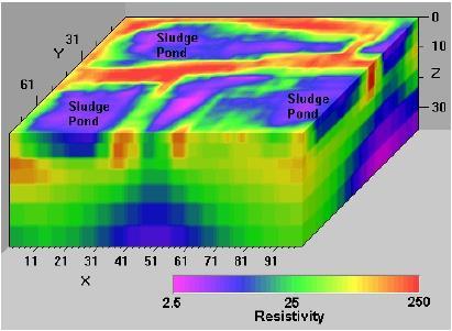
3 Applications Exploration of mineral deposit (sand, gravel) Exploration of groundwater Engineering/construction site investigation Waste sites and pollutant investigations Cavity, karst detection Glaciology, permafrost Archaeological investigations 3
4 1. Resistivity of rocks 4
5 resistivity in ohm.m ( m) conductivity in Siemens per meter (S/m) Resistivity is the physical property which determines the aptitude of this material to be opposed to the passage of the electrical current 5

6 Electrolytic conductivity The current is carried by ions. The electrical resistivity of rocks bearing water is controlled mainly by the water which they contain. 6
7 Electrolytic conductivity The resistivity of a rock will depend : on the resistivity of the natural pore water and consequently the quantity of dissolved salts in the electrolyte 1g/liter=1000 ppm on the quantity of electrolyte contained in the unit of rock volume (saturation) on the mode of electrolyte distribution, porosity 7
8 Resistivity of rocks and minerals Air, gas or oil: infinite or very high resistivity. Liquid materials from landfills are generally conductive (<10 ohm.m) 8
9 The resistivity of a rock decreases if The quantity of water increases The salinity increases (quantity of ions) The quantity of clay increases The temperature increases 9
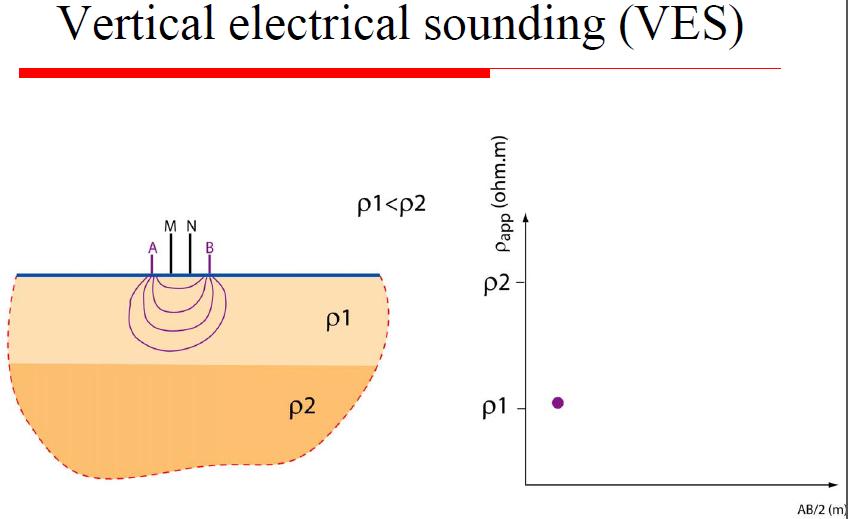
10 2. General principles of resistivity surveying 10
11 Four-electrode system 11
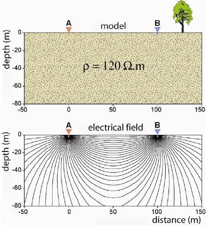
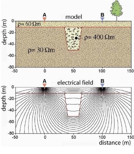
12 Current lines, equipotential surfaces 12
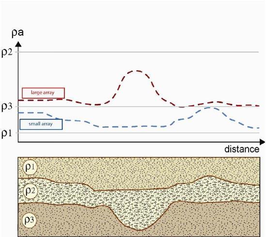
13 Apparent resistivity In a heterogeneous medium, the measured resistivity is an apparent resistivity, which is a function of the form of the inhomogeneity and of the electrode spacing and surface location. K is named the geometric factor. 13

14 Geometric factor For a half-space, a general definition for the geometric factor can be written: 14
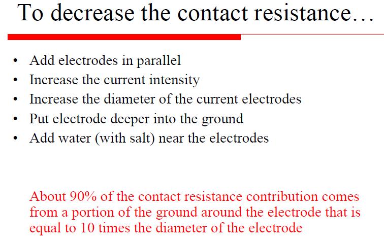
15 Origine of noise Telluric currents Man-made currents Metallic conductors in the ground (short-circuits) Solutions: Use of alternating current Stacking operations Rejection filters (16-20 Hz, Hz) 15
16 Electrode spreads 16
17 Electrode spreads 17
18 Heterogeneous Earth 18
19 Current distribution 19


20 Current distribution This has an influence on the depth of investigation! 20
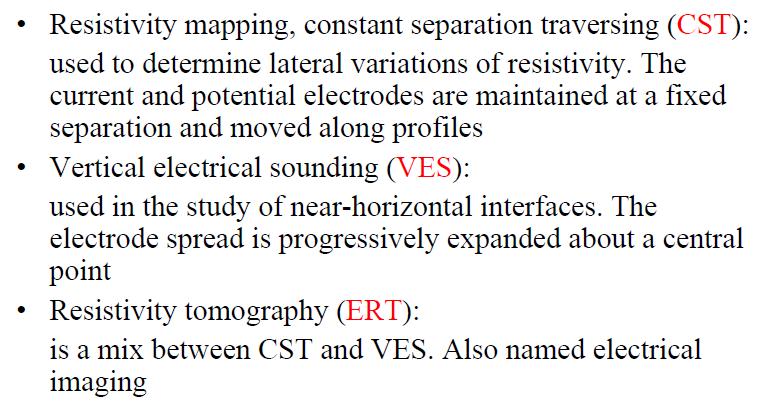
21 Current distribution 21
22 22
23 23

24 23 24
25 25
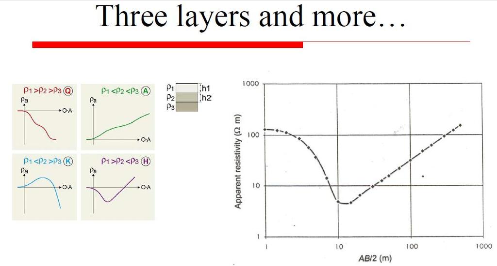
26 3. Field procedures and interpretation 26
27 Field Procedures 27
28 Constant separation traversing (CST) 28
29 Constant separation traversing (CST) 29
 30")
30 Constant separation traversing (CST) 30
31 Constant separation traversing (CST) 31
32 Constant separation traversing (CST) 32
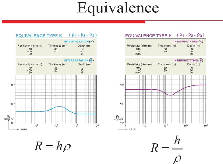
33 Interpretation of CST 33
34 34
35 35
36 36
37 37
38 38
39 39
40 40
41 41
42 42
43 43
44 44
45 45
46 46
47 47
48 48
49 2D resistivity tomography 49
50 2D apppseudosection 50

51 Forward / inverse problems 51

52 2D and 3D models 2D 3D 52
53 Advantages Resistivity surveys are simple and robust Non expensive Allows for a rapid qualitative mapping of the underground Can be used for a 2D or 3D investigation of the subsurface Resistivity contrasts are often present in geological deposits 53
54 Drawbacks Sensitive to non-unicity in the modeling solutions Sensitivity to noise and metallic bodies such as pipes (urban area) Method mainly sensitive to the fluid in rocks. Good for hydrology but a problem in archeology and soil investigations: the signature of a feature can dramatically change with the seasons or weather conditions! 54
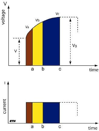
55 Induced Polarization Method 55
56 Induced polarization (IP) is an electromagnetic method that uses electrodes with time-varying currents and voltages to map the variation of electrical Permittivity (dielectric constant) in the Earth at low frequencies. Induced polarization is observed when a steady current through two electrodes in the Earth is shut off: the voltage does not return to zero instantaneously, but rather decays slowly, indicating that charge has been stored in the rocks. This charge, which accumulates mainly at interfaces between clay minerals, is responsible for the IP effect. The IP effect can be measured in either the time domain by observing the rate of decay of voltage, or in the frequency domain by measuring phase shifts between sinusoidal currents and voltages. 56
57 Induced Polarization (IP) effect is seen primarily with metallic sulfides, graphite, and clays. For this reason, IP surveys have been used extensively in mineral exploration. Recently, IP has been applied to hazardous waste landfill and groundwater investigations to identify clay zones. 57
58 5. General principles of IP and measured parameters 58
59 Basic theory 59
60 Membrane polarization Membrane polarization occurs when pore space narrows to within several boundary layer thicknesses. Charges accumulate when an electric field is applied. 60
61 Electrode polarization Electrode polarization occurs when pore space is blocked by metallic particles. Again charges accumulate when an electric field is applied. The result is two electrical double layers which add to the voltage measured at the surface. 61
62 Note that membrane and electrode polarizations cannot be separately identified! 62
63 Time-domain IP Ma is the apparent chargeability in milliseconds (ms) 63
64 Frequency-domain IP PFE PFE 64
65 Frequency-domain IP PFE 65
66 6. IP properties of rocks 64

67 Chargeability of minerals Concentration 1 %, current injection time 3 s, integration time 1 s 67

68 Chargeability of rocks Current injection time 3 s, integration time 0.02 s to 1s 68
69 IP effect is higher for disseminated than massive clay and metallic particles depends on the concentration of clay and metallic particles increases if water in the ground has a low conductivity increases with decreasing porosity varies with the amount of water in the ground depends on the current intensity and the current frequency 69
70 7. Field procedures, interpretation and examples 70
71 IP measurements Different measurement devices for Time-domain IP and Frequency-domain IP Same electrode arrays (for mapping and sounding) as in conventional resistivity Sensitive to telluric noise Sensitive to noise resulting from electromagnetic coupling between adjacent wires (dipole-dipole array very useful) Stability of potential measurements can be a problem (use non polarizable electrodes) 71
72 Interpretation Mainly qualitative, more complex than for resistivity Inversion using iterative algorithms (similar to resistivity) 72
73 Mining geophysics 73
74 74
75 Advantages Detection of disseminated mineral (difficult with resistivity) Method sensitive to clay in aquifers 75
76 Drawbacks Same disadvantages as resistivity method IP surveys is slow and more expensive than resistivity surveys 76
Electrical Surveying (part A)
") Electrical Surveying (part A) Dr. Laurent Marescot Course given at the University of Fribourg (2009) Contact: laurent@tomoquest.com www.tomoquest.com 1 Introduction Electrical surveying Resistivity method
Electrical Surveying (part A) Dr. Laurent Marescot Course given at the University of Fribourg (2009) Contact: laurent@tomoquest.com www.tomoquest.com 1 Introduction Electrical surveying Resistivity method
Introduction. Electrical surveying. Resistivity method Induced polarization method (IP) Self-potential (SP) method
 Self-potential (SP) method") Introduction Electrical surveying Resistivity method Induced polarization method (IP) Self-potential (SP) method Higher frequency methods (electromagnetic surveys): Electromagnetic induction methods Ground
Introduction Electrical surveying Resistivity method Induced polarization method (IP) Self-potential (SP) method Higher frequency methods (electromagnetic surveys): Electromagnetic induction methods Ground
Geophysics for Environmental and Geotechnical Applications
 Geophysics for Environmental and Geotechnical Applications Dr. Katherine Grote University of Wisconsin Eau Claire Why Use Geophysics? Improve the quality of site characterization (higher resolution and
Variation of Moisture Content as a Parameter of Study by Induced Polarization Technique in Soil Sample of Coastal Andhra Pradesh
 Cloud Publications International Journal of Advanced Civil Engineering and Architecture Research 2012, Volume 1, Issue 1, pp. 1-5, Article ID Tech-27 Research Article Open Access Variation of Moisture
Geology 228/378 Applied & Environmental Geophysics Lecture 8. Induced Polarization (IP) and Nuclear Magnetic Resonance (NMR)
 and Nuclear Magnetic Resonance (NMR)") Geology 228/378 Applied & Environmental Geophysics Lecture 8 Induced Polarization (IP) and Nuclear Magnetic Resonance (NMR) Induced Polarization (IP) and Nuclear Magnetic Resonance (NMR) 1. Time domain
Geology 228/378 Applied & Environmental Geophysics Lecture 8 Induced Polarization (IP) and Nuclear Magnetic Resonance (NMR) Induced Polarization (IP) and Nuclear Magnetic Resonance (NMR) 1. Time domain
Geophysics of Exploration for Water. Geoelectric methods III. edited by Peter Vass
 Geophysics of Exploration for Water Geoelectric methods III edited by Peter Vass The phenomenon of induced polarization was already noticed at the early stage of applying direct current electrical methods
Electrical prospecting involves detection of surface effects produced by electrical current flow in the ground.
 Electrical Surveys in Geophysics Electrical prospecting involves detection of surface effects produced by electrical current flow in the ground. Electrical resistivity method Induced polarization (IP)
Geophysics Course Introduction to DC Resistivity
 NORAD supported project in MRRD covering Capacity Building and Institutional Cooperation in the field of Hydrogeology for Faryab Province Afghanistan Geophysics Course Introduction to DC Resistivity By
Part II: Self Potential Method and Induced Polarization (IP)
") Part II: Self Potential Method and Induced Polarization (IP) Self-potential method (passive) Self-potential mechanism Measurement of self potentials and interpretation Induced polarization method (active)
Part II: Self Potential Method and Induced Polarization (IP) Self-potential method (passive) Self-potential mechanism Measurement of self potentials and interpretation Induced polarization method (active)
CONTENTS 1. INTRODUCTION. 2. THE D.C. RESISTIVITY METHOD 2.1 Equipment 2.2 Survey Procedure 2.3 Data Reduction
 (i) CONTENTS 1. INTRODUCTION page 1 2. THE D.C. RESISTIVITY METHOD 2.1 Equipment 2.2 Survey Procedure 2.3 Data Reduction 3 3 3 3 3. GEOPHYSICAL RESULTS 3.1 General 3.2 Discussion 4 4 4 4. LIMITATIONS 5
MOUNT POLLEY MINING CORPORATION TECHNICAL REPORT ON MULTI-ELECTRODE RESISTIVITY AND SEISMIC REFRACTION SURVEYS MOUNT POLLEY TAILINGS DAM PROJECT
 MOUNT PLEY MINING CORPORATION TECHNICAL REPORT ON MULTI-ELECTRODE RESISTIVITY AND SEISMIC REFRACTION SURVEYS MOUNT PLEY TAILINGS DAM PROJECT LIKELY, B.C. by Claudia Krumbiegel, M.Sc. Cliff Candy, P.Geo.
GLE 594: An introduction to applied geophysics
 GLE 594: An introduction to applied geophysics Electrical Resistivity Methods Fall 2004 Earth Properties and Basic Theory Reading Today : 207-218 Next Lecture : 218-228 1 Introduction Link resistivity
OPERATIVE GUIDE INDUCED POLARIZATION
 OPERATIVE GUIDE INDUCED POLARIZATION 1 Induced polarization geoelectric procedure Generals Induced polarization (capacitive effect) represents attitude of a material to collect electric charges of opposite
Geoelectricity. ieso 2010
 Geoelectricity ieso 2010 1 RESISTIVITY SURVEY AT VENETO VILLA GRITTI AT THE TOWN OF TREVISO (VENETO REGION) The survey was carried out to verify the underground presence of the fondations of a rustic building.
2-D Resistivity Study: The Horizontal Resolution Improvement by Introducing the Enhancing Horizontal Resolution (EHR) Technique
 Technique") Open Journal of Geology, 213, 3, 1-6 doi:1.4236/ojg.213.32b1 Published Online April 213 (http://www.scirp.org/journal/ojg) 2-D Resistivity Study: The Horizontal Resolution Improvement by Introducing the
Open Journal of Geology, 213, 3, 1-6 doi:1.4236/ojg.213.32b1 Published Online April 213 (http://www.scirp.org/journal/ojg) 2-D Resistivity Study: The Horizontal Resolution Improvement by Introducing the
ELECTRICAL RESISTIVITY TOMOGRAPHY
 NOTIO Association Clay Technological Centre C/ Río Cabriel s/n 45007 Toledo Tel.: 925 24 11 62 info@notio.es www.notio.es Page 1 / 7 SUMMARY 1. PHYSICAL FUNDAMENTALS OF THE... 3 1.1. ELECTRICAL BEHAVIOR
Geophysics Course Interpreting DC Resistivity Data
 NORAD supported project in MRRD covering Capacity Building and Institutional Cooperation in the field of Hydrogeology for Faryab Province Afghanistan Geophysics Course Interpreting DC Resistivity Data
EXTREMELY FAST IP USED TO DELINEATE BURIED LANDFILLS. Norman R. Carlson, Cris Mauldin Mayerle, and Kenneth L. Zonge
 EXTREMELY FAST IP USED TO DELINEATE BURIED LANDFILLS Norman R. Carlson, Cris Mauldin Mayerle, and Kenneth L. Zonge Zonge Engineering and Research Organization, Inc. 3322 East Fort Lowell Road Tucson, Arizona,
Groundwater Sustainability at Wadi Al Bih Dam, Ras El Khaimah, United Arab Emirates (UAE) using Geophysical methods
 using Geophysical methods") Groundwater Sustainability at Wadi Al Bih Dam, Ras El Khaimah, United Arab Emirates (UAE) using Geophysical methods Ahmed Murad, Amir Gabr, Saber Mahmoud, Hasan Arman & Abdulla Al Dhuhoori Geology Department
Groundwater Sustainability at Wadi Al Bih Dam, Ras El Khaimah, United Arab Emirates (UAE) using Geophysical methods Ahmed Murad, Amir Gabr, Saber Mahmoud, Hasan Arman & Abdulla Al Dhuhoori Geology Department
ambiguity in earth sciences IESO Geophysics Section Eddy hartantyo, Lab Geofisika FMIPA UGM
 ambiguity in earth sciences IESO Geophysics Section Eddy hartantyo, Lab Geofisika FMIPA UGM Pelatihan Tahap II IESO Teknik Geologi UGM Februari 2009 1 Introduction Photos from http://www.eegs.org/whatis/
LIST OF FIGURES APPENDICES
 RESISTIVITY / INDUCED POLARIZATION SURVEY EL PORVENIR PROJECT MUNICIPALITY OF REMEDIOS, ANTIOQUIA, COLOMBIA LOGISTICS REPORT M-17427 APRIL 2017 TABLE OF CONTENTS Abstract... 1 1. The Mandate... 2 2. El
INTRODUCTION TO APPLIED GEOPHYSICS
 INTRODUCTION TO APPLIED GEOPHYSICS EXPLORING THE SHALL0W SUBSURFACE H. Robert Burger Anne F. Sheehan Craig H.Jones VERSITY OF COLORADO VERSITY OF COLORADO W. W. NORTON & COMPANY NEW YORK LONDON Contents
Surface and borehole electrical resistivity tomography
 Surface and borehole electrical resistivity tomography Laurent Marescot laurent@tomoquest.com Introduction Surface electrical resistivity surveying is based on the principle that the distribution of electrical
 12 10 8 6 4 2 0 40-50 50-60 60-70 70-80 80-90 90-100 Fresh Water What we will cover The Hydrologic Cycle River systems Floods Groundwater Caves and Karst Topography Hot springs Distribution of water in
Geology 228/378 Applied and Environmental Geophysics Lecture 6. DC resistivity Surveys
 Geology 228/378 Applied and Environmental Geophysics Lecture 6 DC resistivity Surveys Direct current (DC) Resistivity. Introduction 2. Current flow in the ground 3. Schlumberger, Wenner, dipole-dipole,
INDUCED POLARIZATION AND RESISTIVITY LOGGING IN PERMAFROST
 INDUCED POLARIZATION AND RESISTIVITY LOGGING IN PERMAFROST Richard Fortier 1, Michel Allard 2 1. DŽpartement de gžologie et de gžnie gžologique Pavillon Pouliot, UniversitŽ Laval Sainte-Foy (QuŽbec) Canada
Subsurface Characterization using Electrical Resistivity(Dipole-Dipole) method at Lagos State University (LASU) Foundation School, Badagry
 method at Lagos State University (LASU) Foundation School, Badagry") Available online at www.pelagiaresearchlibrary.com Advances in Applied Science Research, 2010, 1 (1): 174-181 Subsurface Characterization using Electrical Resistivity(Dipole-Dipole) method at Lagos State
Available online at www.pelagiaresearchlibrary.com Advances in Applied Science Research, 2010, 1 (1): 174-181 Subsurface Characterization using Electrical Resistivity(Dipole-Dipole) method at Lagos State
Hydrological geophysical relationships
 International PhD Course in HYDROGEOPHYSICS Hydrological geophysical relationships Andrew Binley Lancaster University Overview In the course we will concentrate on electrical, electromagnetic and radar
Case Study: University of Connecticut (UConn) Landfill
 Landfill") Case Study: University of Connecticut (UConn) Landfill Problem Statement:» Locate disposal trenches» Identify geologic features and distinguish them from leachate and locate preferential pathways in fractured
Case Study: University of Connecticut (UConn) Landfill Problem Statement:» Locate disposal trenches» Identify geologic features and distinguish them from leachate and locate preferential pathways in fractured
Inductive source induced polarization David Marchant, Eldad Haber and Douglas W. Oldenburg, University of British Columbia
 David Marchant, Eldad Haber and Douglas W. Oldenburg, University of British Columbia Downloaded /9/3 to 37.8.7.. Redistribution subject to SEG license or copyright; see Terms of Use at http://library.seg.org/
APPLICATION OF ELECTRICAL RESISTIVITY TOMOGRAPHY FOR SAND UNDERWATER EXTRACTION
 International Scientific Conference GEOBALCANICA 2018 APPLICATION OF ELECTRICAL RESISTIVITY TOMOGRAPHY FOR SAND UNDERWATER EXTRACTION Maya Grigorova Ivaylo Koprev University of Mining and Geology St. Ivan
CHARACTERIZATION OF SOIL PROFILE OF DHAKA CITY USING ELECTRICAL RESISTIVITY TOMOGRAPHY (ERT)
") CHARACTERIZATION OF SOIL PROFILE OF DHAKA CITY USING ELECTRICAL RESISTIVITY TOMOGRAPHY (ERT) Mehedi Ahmed ANSARY 1, B.S. Pushpendue BISWAS 2 and Abul KHAIR 3 1 Professor, Department of Civil Engineering
CHARACTERIZATION OF SOIL PROFILE OF DHAKA CITY USING ELECTRICAL RESISTIVITY TOMOGRAPHY (ERT) Mehedi Ahmed ANSARY 1, B.S. Pushpendue BISWAS 2 and Abul KHAIR 3 1 Professor, Department of Civil Engineering
Site Characterization & Hydrogeophysics
 Site Characterization & Hydrogeophysics (Source: Matthew Becker, California State University) Site Characterization Definition: quantitative description of the hydraulic, geologic, and chemical properties
Seismic Surveying. Dr. Laurent Marescot. Course given at the University of Fribourg (2009) Contact:
 Contact:") Seismic Surveying Dr. Laurent Marescot Course given at the University of Fribourg (2009) Contact: laurent@tomoquest.com 1 Introduction Seismic surveying Investigation based on the propagation of man-made
Seismic Surveying Dr. Laurent Marescot Course given at the University of Fribourg (2009) Contact: laurent@tomoquest.com 1 Introduction Seismic surveying Investigation based on the propagation of man-made
EOSC252 - Exercise 9
 Name: 1. Introduction EOSC252 - Exercise 9 Dielectric properties This is really nothing more than a multiple choice / short answer quiz-style assignment. You will need to have done the readings about dielectric
Surface Processes Focus on Mass Wasting (Chapter 10)
") Surface Processes Focus on Mass Wasting (Chapter 10) 1. What is the distinction between weathering, mass wasting, and erosion? 2. What is the controlling force in mass wasting? What force provides resistance?
Surface Processes Focus on Mass Wasting (Chapter 10) 1. What is the distinction between weathering, mass wasting, and erosion? 2. What is the controlling force in mass wasting? What force provides resistance?
An Introduction to Applied and Environmental Geophysics
 An to Applied and Environmental Geophysics 2nd Edition John M. Reynolds Reynolds International Ltd Preface to the 2 na Edition Acknowledgements 1 1.1 1.2 1.3 1.4 1.5 What are 'applied' and 'environmental'
Definition. Useful References
 Introduction to Geophysics Short Course Assignments http://www.mines.edu/fs_home/tboyd/gp311/modules/res/main.html Definition Resistivity Method - Observation of electric fields caused by current introduced
Appendix B: Geophysical Data (Thesis Appendix, 2013)
") Utah State University From the SelectedWorks of David J Richey 2013 Appendix B: Geophysical Data (Thesis Appendix, 2013) David J Richey, Utah State University Available at: https://works.bepress.com/david_richey/2/
Utah State University From the SelectedWorks of David J Richey 2013 Appendix B: Geophysical Data (Thesis Appendix, 2013) David J Richey, Utah State University Available at: https://works.bepress.com/david_richey/2/
Chapter 14. Groundwater
 Chapter 14 Groundwater Importance of groundwater! Groundwater is water found in the pores of soil and sediment, plus narrow fractures in bedrock! Groundwater is the largest reservoir of fresh water that
Hamed Aber 1 : Islamic Azad University, Science and Research branch, Tehran, Iran. Mir Sattar Meshin chi asl 2 :
 Present a Proper Pattern for Choose Best Electrode Array Based on Geological Structure Investigating in Geoelectrical Tomography, in order to Get the Highest Resolution Image of the Subsurface Hamed Aber
Chapter 4 Influences of Compositional, Structural and Environmental Factors on. Soil EM Properties
 Chapter 4 Influences of Compositional, Structural and Environmental Factors on Soil EM Properties 4. 1 Introduction The measured soil electromagnetic properties can be affected by a large number of factors
B7 Applications of DC resistivity exploration
 B7 Applications of DC resistivity exploration Modern DC resistivity surveys collect data for generating a 2-D or 3-D geoelectric model of the Earth. A simple 1-D analysis does not often yield results that
Geology 228 Applied & Environmental Geophysics Lecture 9
 Geology 228 Applied & Environmental Geophysics Lecture 9 Geomagnetism and magnetic surveys Induced Polarization (IP) Nuclear Magnetic Resonance (NMR) 1. The magnetic field of the earth 2. Magnetic prospecting
Improved Exploration, Appraisal and Production Monitoring with Multi-Transient EM Solutions
 Improved Exploration, Appraisal and Production Monitoring with Multi-Transient EM Solutions Folke Engelmark* PGS Multi-Transient EM, Asia-Pacific, Singapore folke.engelmark@pgs.com Summary Successful as
ELECTRICAL PROSPECTING METHODS
 Suez Canal University Faculty of Science Department of Geology ELECTRICAL PROSPECTING METHODS Prepared By El-Arabi Hendi Shendi Professor of applied & environmental Geophysics 2008 1 CONTENTS Definitions
Geophysical mapping and imaging of soil structures: basic overview
 Geophysical mapping and imaging of soil structures: basic overview Stéphane Garambois Landslide team, LGIT, Université Joseph Fourier 3D imaging of the water table (seismic) Geophysical methods 1 Plan
Report of Induced Polarization Surveys and. Total Field Magnetic Surveys. Turtle Pond, Emmons Lake, Prig, North Glatz, Glatz, and Double E Grids
 Report of nduced Polarization Surveys and Total Field Magnetic Surveys On the Turtlepond Project Turtle Pond, Emmons Lake, Prig, North Glatz, Glatz, and Double E Grids Turtlepond Lake Area, Ontario Claim
Electrical Methods. Resistivity Surveying
 Electrical Methods Resistivity Surveying Geologic Resistivity 1101 Resistivity surveying investigates variations of electrical resistance, by causing an electrical current to flow through the subsurface
Use of Non-Invasive Near-Surface Geophysics for Managing Brine Releases
 Use of Non-Invasive Near-Surface Geophysics for Managing Brine Releases Presented by: Brent W. Barker, Staff Geophysicist Remediation Technologies Symposium 2012 Imagine the result Co-Authors Boyce L.
INTEGRATED INVESTIGATION TO LOCATE A WASTE DISPOSAL AREA
 INTEGRATED INVESTIGATION TO LOCATE A WASTE DISPOSAL AREA 1 FOR OIL DRILLING PRODUCTS G. APOSTOLOPOULOS 2, K. PAVLOPOULOS 3, C. ANTONIADES 4, I. LOUIS 5 and C. VLACHOU 4 Nestoros 1, 17564 P.Faliron, Athens,
Analysis of electrical resistivity data for the determination of aquifer depth at Sapele RD in Benin city
 Available online at www.pelagiaresearchlibrary.com Advances in Applied Science Research, 203, 4(6):268-276 ISSN: 0976-860 CODEN (USA): AASRFC Analysis of electrical resistivity data for the determination
ธรณ ฟ ส กส อ.ดร. ส ว มล อ ดพ วย
 205482 Geophysics ธรณ ฟ ส กส อ.ดร. ส ว มล อ ดพ วย E-mail: suwimons@hotmail.com Office: GB111-4 ภาคว ชาธรณ ว ทยา คณะว ทยาศาสตร มหาว ทยาล ยเช ยงใหม มหาวทยาลยเชยงใหม GEOPHYSICS Physics of the earth = applies
water L v i Chapter 4 Saturation
 4. Resistivity The presence of hydrocarbons is identified by the electrical resistance of the formation. These electrical properties of rocks depend on the pore geometry and fluid distribution. That is,
What is a water table? What is an aquifer? What is the difference between a spring and a well?
 CHAPTER 11 3 Water Underground SECTION The Flow of Fresh Water BEFORE YOU READ After you read this section, you should be able to answer these questions: What is a water table? What is an aquifer? What
I) Resistivity. Literatur: Telford, Geldart und Sheriff (1990): Applied Geophysics, Second Edition, Cambridge University Press, NY.
 Resistivity. Literatur: Telford, Geldart und Sheriff (1990): Applied Geophysics, Second Edition, Cambridge University Press, NY.") I) Resistivity Literatur: Telford, Geldart und Sheriff (1990): Applied Geophysics, Second Edition, Cambridge University Press, NY. Bender, F. (Hg.) (1985): Angewandte Geowissenschaften, Bd. II, Enke Verlag,
I) Resistivity Literatur: Telford, Geldart und Sheriff (1990): Applied Geophysics, Second Edition, Cambridge University Press, NY. Bender, F. (Hg.) (1985): Angewandte Geowissenschaften, Bd. II, Enke Verlag,
Applied Geophysics for Environmental Site Characterization and Remediation
 Applied Geophysics for Environmental Site Characterization and Remediation MSECA Webinar September 24, 2015 John Mundell, P.E., L.P.G. Ryan Brumbaugh, L.P.G. MUNDELL & ASSOCIATES, INC. Webinar Objective
UBC-GIF: Capabilities for EM Modelling and Inversion of LSBB data
 The University of British Colubia Geophysical Inversion Facility slide 1 UBC-GIF: Capabilities for EM Modelling and Inversion of LSBB data Douglas W. Oldenburg Departent of Earth and Ocean Sciences June
CHAPTER 8 GEOPHYSICAL QUANTITIES
 CHAPTER 8 GEOPHYSICAL QUANTITIES This chapter is substantially based on a report produced by the Environmental and Engineering Geophysical Society titled Applications of Geophysics in Geotechnical and
DETECTION OF GROUNDWATER POLLUTION USING RESISTIVITY IMAGING AT SERI PETALING LANDFILL, MALAYSIA
 JOURNAL OF ENVIRONMENTAL HYDROLOGY The Electronic Journal of the International Association for Environmental Hydrology On the World Wide Web at http://www.hydroweb.com VOLUME 8 2000 DETECTION OF GROUNDWATER
Resistivity & IP methods
 International PhD Course in HYDROGEOPHYSICS Resistivity & IP methods Andrew Binley Lancaster University Overview We have demonstrated links between hydrological and geophysical properties and show the
POTASH DRAGON CHILE GEOPHYSICAL SURVEY TRANSIENT ELECTROMAGNETIC (TEM) METHOD. LLAMARA and SOLIDA PROJECTS SALAR DE LLAMARA, IQUIQUE, REGION I, CHILE
 METHOD. LLAMARA and SOLIDA PROJECTS SALAR DE LLAMARA, IQUIQUE, REGION I, CHILE") POTASH DRAGON CHILE GEOPHYSICAL SURVEY TRANSIENT ELECTROMAGNETIC (TEM) METHOD LLAMARA and SOLIDA PROJECTS SALAR DE LLAMARA, IQUIQUE, REGION I, CHILE OCTOBER 2012 CONTENT Page I INTRODUCTION 1 II FIELD
POTASH DRAGON CHILE GEOPHYSICAL SURVEY TRANSIENT ELECTROMAGNETIC (TEM) METHOD LLAMARA and SOLIDA PROJECTS SALAR DE LLAMARA, IQUIQUE, REGION I, CHILE OCTOBER 2012 CONTENT Page I INTRODUCTION 1 II FIELD
Chapter 13. Groundwater
 Chapter 13 Groundwater Introduction Groundwater is all subsurface water that completely fills the pores and other open spaces in rocks, sediments, and soil. Groundwater is responsible for forming beautiful
Geophysical Applications GPR Ground Penetrating Radar
 Overview: Basics of GPR Radar-wave velocity, attenuation and skin depth Modes of acquisition The Radar-range equation Dielectric properties of materials and relation to porosity Case studies [Archeology,
The Use of Vertical Electrical Sounding (VES) for Subsurface Geophysical Investigation around Bomo Area, Kaduna State, Nigeria
 for Subsurface Geophysical Investigation around Bomo Area, Kaduna State, Nigeria") IOSR Journal of Engineering (IOSRJEN) e-issn: 2250-3021, p-issn: 2278-8719 Vol. 3, Issue 1 (Jan. 2013), V4 PP 10-15 The Use of Vertical Electrical Sounding (VES) for Subsurface Geophysical Investigation
IOSR Journal of Engineering (IOSRJEN) e-issn: 2250-3021, p-issn: 2278-8719 Vol. 3, Issue 1 (Jan. 2013), V4 PP 10-15 The Use of Vertical Electrical Sounding (VES) for Subsurface Geophysical Investigation
What we will cover. The Hydrologic Cycle. River systems. Floods. Groundwater. Caves and Karst Topography. Hot springs
 Fresh Water What we will cover The Hydrologic Cycle River systems Floods Groundwater Caves and Karst Topography Hot springs On a piece of paper, put these reservoirs of water in to order from largest to
LECTURE 10. Module 3 : Field Tests in Rock 3.6 GEOPHYSICAL INVESTIGATION
 LECTURE 10 3.6 GEOPHYSICAL INVESTIGATION In geophysical methods of site investigation, the application of the principles of physics are used to the study of the ground. The soil/rock have different characteristics
Vertical electrical sounding (VES) for subsurface geophysical investigation in Kanigiri area, Prakasam district, Andhra Pradesh, India
 for subsurface geophysical investigation in Kanigiri area, Prakasam district, Andhra Pradesh, India") Available online at www.pelagiaresearchlibrary.com Advances in Applied Science Research, 2014, 5(5):82-86 ISSN: 0976-8610 CODEN (USA): AASRFC Vertical electrical sounding (VES) for subsurface geophysical
Available online at www.pelagiaresearchlibrary.com Advances in Applied Science Research, 2014, 5(5):82-86 ISSN: 0976-8610 CODEN (USA): AASRFC Vertical electrical sounding (VES) for subsurface geophysical
CHAPTER 5 GEOPHYSICAL SURVEY. 5.1 Purpose of Survey
 CHAPTE 5 GEOPHYSICAL SUVEY 5.1 Purpose of Survey The objective of the Time Domain Electro- Magnetic (TDEM) survey was to define the electrical structure of the Stampriet Artesian Basin and relate this
GLG 471; MICHIGAN STATE UNIVERSITY INSTRUCTOR R.L. VAN DAM PROJECT: ELECTRICAL RESISTIVITY
 GLG 471; MICHIGAN STATE UNIVERSITY INSTRUCTOR R.L. VAN DAM PROJECT: ELECTRICAL RESISTIVITY General information: This is a group (2-3 students) project requiring lab-, computer-, and fieldwork. Work will
Karst Topography In order to understand karst topography we must first have a basic understanding of the water cycle, the formation of limestone (carb
 Karst Topography The formation of caves and other associated features in limestone bedrock is called karst topography. Limestone, a sedimentary rock made mostly of the mineral calcite and small amounts
The Role of Magnetotellurics in Geothermal Exploration
 The Role of Magnetotellurics in Geothermal Exploration Adele Manzella CNR - Via Moruzzi 1 56124 PISA, Italy manzella@igg.cnr.it Foreword MT is one of the most used geophysical methods for geothermal exploration.
Vertical Electrical Sounding (Ves) For The Determination Of Under Ground Resistivity In Part Of Nigeria Wilberforce Island,Amassoma, Bayelsa State
 For The Determination Of Under Ground Resistivity In Part Of Nigeria Wilberforce Island,Amassoma, Bayelsa State") IOSR Journal of Research & Method in Education (IOSR-JRME) e-issn: 2320 7388,p-ISSN: 2320 737X Volume 7, Issue 2 Ver. III (Mar. - Apr. 2017), PP 53-61 www.iosrjournals.org Vertical Electrical Sounding
IOSR Journal of Research & Method in Education (IOSR-JRME) e-issn: 2320 7388,p-ISSN: 2320 737X Volume 7, Issue 2 Ver. III (Mar. - Apr. 2017), PP 53-61 www.iosrjournals.org Vertical Electrical Sounding
Essentials of Geology, 11e
 Essentials of Geology, 11e Groundwater Chapter 10 Instructor Jennifer Barson Spokane Falls Community College Geology 101 Stanley Hatfield Southwestern Illinois Co Jennifer Cole Northeastern University
Titiribi Gold: Sleeping Giant in the Colombian Cordilleras (a Geophysical Study)
") Titiribi Gold: Sleeping Giant in the Colombian Cordilleras (a Geophysical Study) Emmett Van Reed, P.Gp. Zonge Engineering & Research Amit Tripathi, Ph.D. Terra Resources Development Technologies Jennifer
Titiribi Gold: Sleeping Giant in the Colombian Cordilleras (a Geophysical Study) Emmett Van Reed, P.Gp. Zonge Engineering & Research Amit Tripathi, Ph.D. Terra Resources Development Technologies Jennifer
The Efficacy of Enhancing Horizontal Resolution (EHR) Technique in Shallow Subsurface Study Using 2D Resistivity Method at Bukit Bunuh
 Technique in Shallow Subsurface Study Using 2D Resistivity Method at Bukit Bunuh") 212 International Conference on Geological and Environmental Sciences IPCBEE vol.3 6(212) (212)IACSIT Press, Singapoore The Efficacy of Enhancing Horizontal Resolution (EHR) Technique in Shallow Subsurface
212 International Conference on Geological and Environmental Sciences IPCBEE vol.3 6(212) (212)IACSIT Press, Singapoore The Efficacy of Enhancing Horizontal Resolution (EHR) Technique in Shallow Subsurface
3. Magnetic Methods / 62
 Contents Preface to the Second Edition / xv Excerpts from Preface to the FirstEdition / xvii Mathematical Conventions / xix 1. Introduction / 1 Reference / 5 2. Gravity Methods / 6 2. I. Introduction /
WATER ON AND UNDER GROUND. Objectives. The Hydrologic Cycle
 WATER ON AND UNDER GROUND Objectives Define and describe the hydrologic cycle. Identify the basic characteristics of streams. Define drainage basin. Describe how floods occur and what factors may make
Magnetotelluric (MT) Method
 Method") Magnetotelluric (MT) Method Dr. Hendra Grandis Graduate Program in Applied Geophysics Faculty of Mining and Petroleum Engineering ITB Geophysical Methods Techniques applying physical laws (or theory) to
Magnetotelluric (MT) Method Dr. Hendra Grandis Graduate Program in Applied Geophysics Faculty of Mining and Petroleum Engineering ITB Geophysical Methods Techniques applying physical laws (or theory) to
OWNER OPERATOR: BLACKWATER EXPLORATIONS LTD. REPORT ON RESISTIVITY PROFILING SURVEY PLACER GOLD EXPLORATION
 OWNER OPERATOR: BLACKWATER EXPLORATIONS LTD. REPORT ON RESISTIVITY PROFILING SURVEY PLACER GOLD EXPLORATION CARIBOO MINING DISTRICT NTS 93G CLAIM PC682023 Latitude 53 13 35.64 Longitude 122 49 40.65 by
Major Points in Introduction
 Near- Surface Processes and Resources John Louie - louie@seismo.unr.edu eismo. unr.edu Thomas Pratt tpratt@ocean.washington.edu ashington.edu Here is a Laundry List- With it, we can prioritize Major Points
Groundwater Level Monitoring of the Quaternary Aquifer at Al Ain City, United Arab Emirates (UAE) using Geophysical Methods
 using Geophysical Methods") Groundwater Level Monitoring of the Quaternary Aquifer at Al Ain City, United Arab Emirates (UAE) using Geophysical Methods Ahmed Murad & Amir Gabr Geology Department UAE University Outlines Introduction
Groundwater Level Monitoring of the Quaternary Aquifer at Al Ain City, United Arab Emirates (UAE) using Geophysical Methods Ahmed Murad & Amir Gabr Geology Department UAE University Outlines Introduction
REPORT ON THE INDUCED POL A.RIZA.TION AND RESISTIVITY SURVEY ON THE PAM CLAIMS, DODD LAKE AREA. VA.NCOUVER MINING DIVISION, B. C.
 DAVID K. FOUNTAIN, P. Eng. I REPORT ON THE INDUCED POL A.RIZA.TION AND RESISTIVITY SURVEY ON THE PAM CLAIMS, DODD LAKE AREA. VA.NCOUVER MINING DIVISION, B. C. 3 2 i /,,I& FOR THE $, REDONDA SYNDICATE Mines
2D Resistivity Imaging Investigation of Solid Waste Landfill Sites in Ikhueniro Municipality, Ikpoba Okha Local Government Area,Edo State, Nigeria.
 2D Resistivity Imaging Investigation of Solid Waste Landfill Sites in Ikhueniro Municipality, Ikpoba Okha Local Government Area,Edo State, Nigeria. Iyoha. A, Akhirevbulu O.E, Amadasun C.V.O and Evboumwan
EARTH SCIENCE 11 CHAPTER 9 NOTES WATER MOVING UNDERGROUND
 EARTH SCIENCE 11 CHAPTER 9 NOTES WATER MOVING UNDERGROUND KEY A. ALL THE WORLD S WATER 1. The world has an estimated one and one third thousand million cubic kilometers of water. 2. The earth s water is
Ground subsidence is a worldwide problem especially
 Ground Engineering: GPR A Case Study on Ground Subsidence Using Ground Penetrating Radar Nur Azwin Ismail and Rosli Saad Geophysics Section, School of Physics, Universiti Sains Malaysia Ground subsidence
Seismoelectric Ground-flow DC-4500 Locator
 Seismoelectric Ground-flow DC-4500 Locator Introduction The seismoelectric survey is a new technology combined the electro kinetic potential method and geophysical technology. It is applied directly to
2-D Resistivity Imaging in Taiping, Perak, Malaysia
 2-D Resistivity Imaging in Taiping, Perak, Malaysia A. I. Rosli *,1, M. A. Mohamed Zawawi 1, H. Juahir 2, N. Z. Karim 3 and N. F. Yusof 1 1 Department of Biological and Agricultural Engineering, Faculty
Short guide for resistivity and induced polarization tomography
 Short guide for resistivity and induced polarization tomography Address of the manufacturer: GF Instruments, s.r.o. Purkyňova 144 61200 Brno tel: +420 549 522 919 fax: +420 549 522 915 e-mail: info@gfinstruments.cz
LITTLE ABOUT BASIC PETROPHYSICS
 LITTLE ABOUT BASIC PETROPHYSICS Author: MUHAMMAD ZAHID M.Sc (Applied Geology) Specialization in Petrophysics University of Azad Jammu & Kashmir, Muzaffarabad. ENTER Introduction - Determination of Physical
STUDY GUIDE FOR CONTENT MASTERY. Movement and Storage of Groundwater
 Groundwater SECTION 10.1 Movement and Storage of Groundwater In your textbook, read about the hydrosphere, precipitation and groundwater, and groundwater storage. Use the following terms to complete the
Application of Ground Penetrating Radar for hydro-geological study
 Journal of Scientific & Industrial Research Vol. 65, February 2006, pp. 160-164 Application of Ground Penetrating Radar for hydro-geological study K K K Singh* Central Mining Research Institute, Dhanbad
Prof. Stephen A. Nelson EENS 111. Groundwater
 Page 1 of 8 Prof. Stephen A. Nelson EENS 111 Tulane University Physical Geology This page last updated on 20-Oct-2003 is water that exists in the pore spaces and fractures in rock and sediment beneath
Tu 23P1 06 Mapping Possible Flowpaths of Contaminants through Surface and Cross-borehole Spectral Timedomain Induced Polarization
 Tu 23P1 06 Mapping Possible Flowpaths of Contaminants through Surface and Cross-borehole Spectral Timedomain Induced Polarization T. Bording* (Aarhus University), G. Fiandaca (Aarhus University), P.K.
A case study of crystalline limestone intrusion and fault zone identication using 2d eri technique in Ramco cements, pandalgudi mines, Tamilnadu
 International Research Journal of Geology and Mining (IRJGM) (2276-6618) Vol. 2 (1) pp. 011-015, January 2012 Available online http://www.interesjournals.org/irjgm Copyright 2012 International Research
INJECTION ELECTRODE POLARIZATION IN RESISTIVITY AND INDUCED POLARIZATION
 INJECTION ELECTRODE POLARIZATION IN RESISTIVITY AND INDUCED POLARIZATION J.B. Merriam University of Saskatchewan Department of Geological Sciences 4 Science Pl Saskatoon, SK S7N 5E jim.merriam@usask.ca
Application of 2D Electrical Resistivity Imaging Technique for Engineering Site Investigation
 Application of 2D Electrical Resistivity Imaging Technique for Engineering Site Investigation Asem A. Hassan 2 Munther D. AL-Awsi 1 Mutadhid M. Al-Obaidi 3 1 College of Science, Diyala University, Baqubah,
ECE2262 Electric Circuits. Chapter 6: Capacitance and Inductance
 ECE2262 Electric Circuits Chapter 6: Capacitance and Inductance Capacitors Inductors Capacitor and Inductor Combinations Op-Amp Integrator and Op-Amp Differentiator 1 CAPACITANCE AND INDUCTANCE Introduces
Instructional Objectives
 GE 343 SUBSURFACE EXPLORATION CH 8 Rock Drilling, Testing, and Sampling Text Ch. 7. Dr. Norbert H. Maerz Missouri University of Science and Technology (573) 341-6714 norbert@mst.edu Instructional Objectives
Determining the Relationship between Resistivity, Water and Hydrocarbon Saturation of Rock Formation Using Composite Well Logs
 Determining the Relationship between Resistivity, Water and Hydrocarbon Saturation of Rock Formation Using Composite Well Logs Doi:10.5901/ajis.2013.v2n13p119 Absract Mamudu Afizu Department of Physics,