A GPR ASSESSMENT OF THE NAPLES CANAL 8CR59: PHASE II NAPLES, FLORIDA ARCHAEOLOGICAL AND HISTORICAL CONSERVANCY, INC.
|
|
|
- Branden Small
- 5 years ago
- Views:
Transcription


1 A GPR ASSESSMENT OF THE NAPLES CANAL 8CR59: PHASE II NAPLES, FLORIDA ARCHAEOLOGICAL AND HISTORICAL CONSERVANCY, INC. AHC TECNICAL REPORT NO JUNE 2014
2 A GPR ASSESSMENT OF THE NAPLES CANAL 8CR59: PHASE II NAPLES, FLORIDA By: Robert S. Carr, M.S. Robert M. Baker, CPG, PG John G. Beriault, B.A. ARCHAEOLOGICAL AND HISTORICAL CONSERVANCY, INC SW 64th Avenue, Suite 107 Davie, Florida For: NAPLES BACKYARD HISTORY INC. AHC PROJECT NO AHC TECHNICAL REPORT NO JUNE 2014
3 TABLE OF CONTENTS LIST OF FIGURES CONSULTANT SUMMARY APPENDIX I: GPR SURVEY TECHNICAL REPORT APPENDIX II: FLORIDA SITE FORM 8CR59, 8CR60, 8CR61 ii iii x xi i
4 CONSULTANT SUMMARY In May, 2014, the Archaeological and Historical Conservancy, Inc. (AHC) conducted a Phase II GPR assessment of the Naples Canal for Naples Backyard History Inc. The site (8CR59) is in Township 50S, Range 25E, Sections 9 and 10 (Figure 1). Known since the 1870s but now completely filled, the site extends approximately one mile from the Gulf of Mexico east to Naples Bay. Ground Penetrating Radar (GPR) was used to remotely locate and assess anomalous belowground features likely associated with the canal. Archaeological work conducted near the western terminus of the Naples Canal (Carr et al. 2014) has shown that the 1923 Naples plat map created by surveyor James Bain to be highly accurate in depicting the footprint of the feature. An earlier phase employed remote sensing by GPR followed by mechanical trenching at intersection of Gulfshore Boulevard South and 10 th Avenue South to assess the surviving below-ground components of the canal and to obtain radiocarbon dating samples. The current work phase was conducted at seven locations using at least twenty-eight transects. The GPR work was done with a Ramac X3M manufactured by Maia Geoscience, operated by Robert M. Baker of RM Baker LLC Geology and Geophysics. This assessment generated fifteen profile maps that coincide closely but not completely with the projected canal location based on the 1923 Bain plat. Seven locations along the route of the Naples Canal were examined by running linear transects across the projected path of the canal. The six eastern locations produced GPR results indicating anomalous features likely associated with the Naples Canal. Two of these location excellent prospects for future excavations. It is recommended that future investigations consider these two locations because of their public access and potential foryielding important information. This assessment included updating existing Florida site forms for the Naples Canal, 8CR59, and two prehistoric sit iii

5 CR59 Figure 1. USGS Map of the Naples Canal, 8CR59. TOWNSHIP 50S, RANGE 25E, SECTIONS 9 and 10 USGS Map: NAPLES NORTH, REV /8 1/4 1/2 Mile approx Km. approx. N iv

6 Figure Kenworthy map showing the canal in section, depicting the surface width as 40 feet. Figure 4. Modern map depicting the historical alignment of the Indian Canal (Turrell Hall & Associates). vi


7 Figure 7. GPR scanning conducted at Location 1, east end of canal. Figure 8. GPR scanning conducted at Location 7, west end of canal. ix
8 APPENDIX I: GROUND PENETRATING RADAR SURVEY x


9 RMBAKER LLC Geology and Geophysics GROUN D PENETRATING RADAR SURVEY NAPLES CANAL 8CR59 Naples, Florida RMBAKERR LLC Job No Prepared For Cover image by RMBAKER LLC 2014
10 RMBAKE ER LLC Geology and Geophysicss Boreholee Geophysics Welll Logging Sinkhole Exploration Mineral Exploration 8600 Oldbridge Lane Orlando, FL Ph Fx Certificate of Authorization GB458 REPORT OF FINDINGS Ground Penetrating Radar Survey Scope of Work RMBAKER LLC was retained by AHC to perform a ground penetrating radar (GPR) survey of selected areas and properties in Naples, Collier County, Florida. The purpose of the geophysical survey was to assemble data that would enable interpretations of subsurface cultural conditions potentially associated with a known buried canal (8CR59). In particular, the objective was to locate and map the canal wherever possible. Historical maps of the 1923 canal survey were provided by AHC. The GPR survey field work was performed on May 22, Methods RMBAKER LLC GPR surveys are performed in accordance with ASTM D , Standard Guide for Using the Surface Penetrating Radar Method for Sub-surface Investigation. The GPR survey is designedd to explore the shallow subsurface conditions and to identify possible geologic or cultural features. Geologic features may include sediment distinctions such as erosion surfaces, bedding surfaces, soil composition, soil density,, soil and rock cementation, soil moisture content and void spaces. Cultural features may include underground utilities, drain fields, buried debris, petroleum contamination n, soil backfill, and disturbed soils. The equipment for a GPR survey consists of an antenna,, which both transmits and receives, and a profiling recorder that digitally processes the received signal and produces a graphic display of the data. The antenna transmits short-duration electromagnetic waves into the ground, which are then reflected back to the receiver at different velocities and amplitudes, depending on the nature of the reflector and the surrounding medium. The profiling recorder produces a two dimensional subsurface profile along the traverse taken. RMBAKER LLC utilizes a Ramac X3M manufactured by Mala Geoscience AB. The Ramac X3M is used with a 250 MHz and/or a 500 MHz antenna. The maximum depth of the GPR survey is limited by thee soil and groundwater conditions at the site. The effective depth is recorded as a function of timee (i.e. the time for the signal to penetrate into the soil and return to the receiver), and can bee converted to an approximate depth Page 3 of 6
11 RMBAKE ER LLC Geology and Geophysicss Boreholee Geophysics Welll Logging Sinkhole Exploration Mineral Exploration 8600 Oldbridge Lane Orlando, FL Ph Fx Certificate of Authorization GB458 measurement using known signal velocities. The signall velocities generally vary depending on the soil type and its moisture content. With GPR systems, geologicall artifacts can appear when the ground surface has topographic relief. This occurs because the GPR system follows the contour of the ground surface and imposes that relief upon the subsurface reflections. Ourr interpretations of the GPR geophysical data took into account the changing topography. Discussion and Analysis The maps and profiles are provided in the Florida State Plane East (NAD 1983) coordinate system in units of feet. The eastingg and northing units are shown in feet. Horizontal coordinates on the geophysical profiles are shown in feet, and depths are shown in feet. We utilized a global positioning system (GPS) with submeter accuracy (50 cm +/-) to map the locations of all GPR transects.. When viewing the profiles, the horizontal axes are in feet and State Plane coordinates. State Plane coordinates are Cartesian in the sense that they increase to the east and to the north. All of the profiles in the attachments to this report t have west or south on the left side and east or north on the right side. Each GPR transect is composed of a series of vertical traces or soundings. Consider a trace to be a vertical data package. When these tightly spaced vertical data packages are combined, and colors are assigned based on amplitude, then a profile image in a bitmap format is created. We resampled each GPS polyline to contain the exact number of XY points as traces in the associated GPR data. When the GPS data iss merged into the GPR data, we are able to digitize features from the GPR profiles and map them in a precise location along the GPS polyline. By merging the GPS location dataa into the GPR data after the field data is collected, we are able to post-process and clean the GPS data and remove common irregularities. Ground Penetrating Radar Survey The GPR transect naming convention follows the file naming convention of the field computer used to collect and store the profile data. The recorded file names for this project began with the number 2. Transect 1 was a trial and was not mapped. The following table indicates the survey equipment settings and total lineal footage: Page 4 of 6
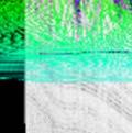
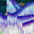
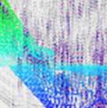
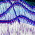
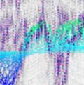
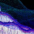
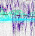
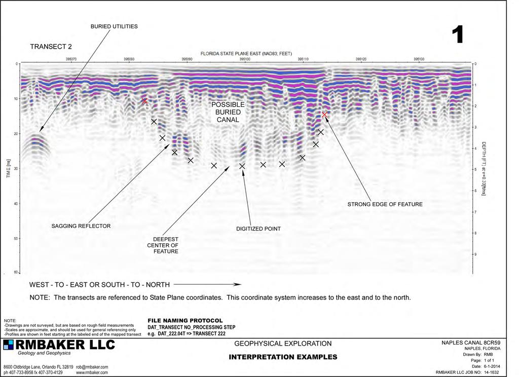
12 RMBAKE ER LLC Geology and Geophysicss Boreholee Geophysics Welll Logging Sinkhole Exploration Mineral Exploration 8600 Oldbridge Lane Orlando, FL Ph Fx Certificate of Authorization GB458 Maximum Lineal Antenna Frequency (MHz) Sampling Range (ns) Velocity (ft/ns) Maximum Depth (ft) Effective Depth (ft) No. of Transects Length of Profiling (ft) 5000 MHz/Medium= NOTE: Sampling range does not account for the direct wave. The entire GPR survey consisted of 28 individuall transects along lineal feet (0.99 miles) of traverses. The depth of the GPR survey was calibrated using published soil velocities, assuming a sandy soill throughout the effective soil profile and using an assumed average signal velocity of 0.33 feet per nanosecond. This velocity may vary across the studied areas, and so the depth axis should be considered an approximation. We detected GPR patterns consistent with the likely presencee of a buried canal all along the 1923 canal alignment (mapped approximately based on a visual review of hardcopy maps). We labeled the areas of recognizable canal patterns according to the numerical sequence provided by AHC. We digitized each GPR anomaly and coded the points to represent; 1) the entire anomaly and the strong edge of the anomaly. We mapped only those points representing the edge of the anomaly feature, although many of the GPR profiles show the entire digitized shape of the anomaly. Difficulty in observing the canal using GPR inn some locations likely arose from; 1) presence of salts in the sandy soils associatedd with seawater flooding of the barrier island, 2) similar soils used to fill the canal as compared to those outside the canal, 3) masking of the canal by soils or hardscape at the ground surface, 4) reworking of the soils during modern utility installations, and 5) generally limited dielectric contrast in the soils. Examples of our interpretation approach are contained in the attachments. We have provided each GPR transect that indicated an anomaly consistent with the presence of the canal. Transects that did not yield an anomaly are on file and can be provided as bitmaps if requested. The attachments also include a series of maps showing the locations of the transects, the anomalies, and our GPR anomaly alignment compared to the 1923 expected canal alignment. Page 5 of 6
13 RMBAKE ER LLC Geology and Geophysicss Boreholee Geophysics Welll Logging Sinkhole Exploration Mineral Exploration 8600 Oldbridge Lane Orlando, FL Ph Fx Certificate of Authorization GB458 Limitations While due care has been exercised in the performance off these measurements and observations, in accordance with methodologies utilized by the general practitioner, RMBAKER LLC can make no epresentations, warranties, or guarantees with respect to latent or concealed conditions that may exist, which may be beyondd the detection capabilities of the methodologies used, or thatt may extend beyond the area and depths surveyed. The analyses and conclusions contained in our report are based on site conditions as they existed at the time of our survey. If, at any time, different subsurface conditions from those interpreted herein are observed to be present, we reserve the right to modify our analyses and conclusions as warranted by the new information. ELECTRONICC VERSION SIGNED AND SEALED HARDCOPY ON FILE Attachments included (maps and imagery) RMBAKER LLC Robert M. Baker, CPG, PG Managing Member Fla. Reg. Geologist No Page 6 of 6
14
A GPR ASSESSMENT OF THE PREHISTORIC NAPLES CANAL NAPLES, FLORIDA ARCHAEOLOGICAL AND HISTORICAL CONSERVANCY, INC.
 A GPR ASSESSMENT OF THE PREHISTORIC NAPLES CANAL NAPLES, FLORIDA ARCHAEOLOGICAL AND HISTORICAL CONSERVANCY, INC. AHC TECNICAL REPORT NO. 1004 DECEMBER 2013 A GPR ASSESSMENT OF THE PREHISTORIC NAPLES CANAL
Sabal Trail Pipeline Project Evaluation of Karst Topography and Sinkhole Potential for Pipeline and Facilities
 November 11, 2014 Sabal Trail Pipeline Project Evaluation of Karst Topography and Sinkhole Potential for Pipeline and Facilities Gulf Interstate Engineering Attention: Mr. Denys Stavnychyi - Project Engineer
FINAL REPORT GEOPHYSICAL INVESTIGATION WATER TOWER NO. 6 SITE PLANT CITY, FL
 APPENDIX B FINAL REPORT GEOPHYSICAL INVESTIGATION WATER TOWER NO. 6 SITE PLANT CITY, FL Prepared for Madrid Engineering Group, Inc. Bartow, FL Prepared by GeoView, Inc. St. Petersburg, FL February 28,
M E M O R A N D U M. Mr. Jonathan K. Thrasher, P.E. and Mr. Ian Kinnear, P.E. PSI
 M E M O R A N D U M TO: FROM: Mr. Mark Schilling Gulf Interstate Engineering Mr. Jonathan K. Thrasher, P.E. and Mr. Ian Kinnear, P.E. PSI DATE: November 11, 2014 RE: Summary of Findings Geotechnical Study
Application of Ground Penetrating Radar for hydro-geological study
 Journal of Scientific & Industrial Research Vol. 65, February 2006, pp. 160-164 Application of Ground Penetrating Radar for hydro-geological study K K K Singh* Central Mining Research Institute, Dhanbad
IMAGING OF DEEP SINKHOLES USING THE MULTI-ELECTRODE RESISTIVITY IMPLANT TECHNIQUE (MERIT) CASE STUDIES IN FLORIDA
 CASE STUDIES IN FLORIDA") IMAGING OF DEEP SINKHOLES USING THE MULTI-ELECTRODE RESISTIVITY IMPLANT TECHNIQUE (MERIT) CASE STUDIES IN FLORIDA David Harro The G3 Group, 2509 Success Drive, Suite 1, Odessa, FL 33556, david.harro@geo3group.com
IMAGING OF DEEP SINKHOLES USING THE MULTI-ELECTRODE RESISTIVITY IMPLANT TECHNIQUE (MERIT) CASE STUDIES IN FLORIDA David Harro The G3 Group, 2509 Success Drive, Suite 1, Odessa, FL 33556, david.harro@geo3group.com
FINAL REPORT GEOPHYSICAL INVESTIGATION VILLAGE ALHAMBRA RETENTION POND SITE THE VILLAGES, FLORIDA
 FINAL REPORT GEOPHYSICAL INVESTIGATION VILLAGE ALHAMBRA RETENTION POND SITE THE VILLAGES, FLORIDA Prepared for Andreyev Engineering, Inc. Oxford, FL Prepared by GeoView, Inc. St. Petersburg, FL August
Ground Penetrating Radar Survey of a Portion of East End Cemetery, Cadiz, Kentucky
 Ground Penetrating Radar Survey of a Portion of East End Cemetery, Cadiz, Kentucky January 2011 Report prepared by Anthony L. Ortmann, Ph.D. Assistant Professor Department of Geosciences Murray State University
Geophysical Investigation of a 19th Century Archeological Site, Boston College K. Corcoran, J. Hager, M. Carnevale
 Geophysical Investigation of a 19th Century Archeological Site, Boston College K. Corcoran, J. Hager, M. Carnevale Hager GeoScience, Inc., Waltham, MA ------------------------------------------------------------------------
GPR AS A COST EFFECTIVE BEDROCK MAPPING TOOL FOR LARGE AREAS. Abstract
 GPR AS A COST EFFECTIVE BEDROCK MAPPING TOOL FOR LARGE AREAS Dr. Jutta L. Hager, Hager GeoScience, Inc., Waltham, MA Mario Carnevale, Hager GeoScience, Inc., Waltham, MA Abstract Hager GeoScience, Inc.
AN ARCHAEOLOGICAL SURVEY FOR THE EASTHAM STATE PRISON FARM UNIT PROJECT IN HOUSTON COUNTY TEXAS
 AN ARCHAEOLOGICAL SURVEY FOR THE EASTHAM STATE PRISON FARM UNIT PROJECT IN HOUSTON COUNTY TEXAS Antiquities Permit 5693 By William E. Moore and Edward P. Baxter Brazos Valley Research Associates Contract
GEOPHYSICAL SITE CHARACTERIZATION IN SUPPORT OF HIGHWAY EXPANSION PROJECT
 GEOPHYSICAL SITE CHARACTERIZATION IN SUPPORT OF HIGHWAY EXPANSION PROJECT * Shane Hickman, * Todd Lippincott, * Steve Cardimona, * Neil Anderson, and + Tim Newton * The University of Missouri-Rolla Department
 SHEET TITLE: DRAWN BY: J.M.CLARK FILE NO. CHECKED BY: W.S. JORDAN APPROVED BY: DATE: FIGURE SHEET TITLE: DRAWN BY: J.M.CLARK FILE NO. CHECKED BY: W.S. JORDAN APPROVED BY: DATE: FIGURE SPOTLIGHT Technical
ELECTRICAL RESISTIVITY SURVEY OF INTREPID POTASH INJECTION WELL SITE: EDDY COUNTY, NEW MEXICO
 NCKRI REPORT OF INVESTIGATION 3 ELECTRICAL RESISTIVITY SURVEY OF INTREPID POTASH INJECTION WELL SITE: EDDY COUNTY, NEW MEXICO www.nckri.org NATIONAL CAVE AND KARST RESEARCH INSTITUTE REPORT OF INVESTIGATION
PHASE 1 STUDIES UPDATE EROSION WORKING GROUP
 PHASE 1 STUDIES UPDATE EROSION WORKING GROUP Presented By MICHAEL WOLFF, PG Erosion Study Area Manager West Valley Demonstration Project Quarterly Public Meeting February 24, 2016 OUTLINE Study 1 Terrain
Comparison of geophysical. techniques to determine depth to. bedrock in complex weathered. environments of the Mount Crawford. region, South Australia
 Comparison of geophysical techniques to determine depth to bedrock in complex weathered environments of the Mount Crawford region, South Australia Thesis submitted in accordance with the requirements of
Ardaman & Associates, Inc. Geotechnical, Environmental and Materials Consultants
 SUBSURFACE SOIL EXPLORATION 42-INCH FORCE MAIN REPLACEMENT CHIQUITA BOULEVARD S AND SW 34 TH STREET CAPE CORAL, LEE COUNTY, FLORIDA Ardaman & Associates, Inc. Geotechnical, Environmental and Materials
Use of Non-Invasive Near-Surface Geophysics for Managing Brine Releases
 Use of Non-Invasive Near-Surface Geophysics for Managing Brine Releases Presented by: Brent W. Barker, Staff Geophysicist Remediation Technologies Symposium 2012 Imagine the result Co-Authors Boyce L.
GEOSYNTEC CONSULTANTS
 GEOSYNTEC CONSULTANTS 2100 Main Street, Suite 150 Huntington Beach, CA 92648 USA Tel (714) 969-0800 Fax (714) 969-0820 15 February 2006 Ms. Tamara Zeier, P.E. Project Manager Project Navigator, Ltd. One
MESOZOIC BASINS. North Carolina Geological Survey
 MESOZOIC BASINS North Carolina Geological Survey The 1823 organic act which created the North Carolina Geological Survey (NCGS) tasked us to examine, describe and map the geology, geologic hazards, and
AN ARCHAEOLOGICAL SURVEY FOR THE DCP MIDSTREAM THREE RIVERS PLANT TO CGP 51 PROJECT IN LIVE OAK COUNTY, TEXAS
 AN ARCHAEOLOGICAL SURVEY FOR THE DCP MIDSTREAM THREE RIVERS PLANT TO CGP 51 PROJECT IN LIVE OAK COUNTY, TEXAS By William E. Moore Brazos Valley Research Associates Contract Report Number 251 2011 AN ARCHAEOLOGICAL
Although most karstic regions
 Urban Geophysics: Geophysical Signature of Mount Bonnell Fault and Its Karstic Features in Austin, TX by Mustafa Saribudak, Environmental Geophysics Associates, Austin, TX Although most karstic regions
Hazard Mapping Along the Dead Sea Shoreline
 FIG Working Week in Marrakech, Morocco 18-22 May 2011 Hazard Mapping Along the Dead Sea Shoreline Rami Al-Ruzouq, Abdullah Al-Zuobi, AbdEl-Rahman Abueladas, Emad Akkawi Department of Surveying and Geomatics
Sacred Lands File & Native American Contacts List Request
 Sacred Lands File & Native American Contacts List Request NATIVE AMERICAN HERITAGE COMMISSION 915 Capitol Mall, RM 364 Sacramento, CA 95814 (916) 653-4082 (916) 657-5390 Fax nahc@pacbell.net Information
Geophysical Survey of Wisconsin Burial Site BRO-0033 Wixom Cemetery, Rock County, Wisconsin
 Lawrence University Lux Archaeological Reports Anthropology Department 6-2015 Geophysical Survey of Wisconsin Burial Site BRO-0033 Wixom Cemetery, Rock County, Wisconsin Peter N. Peregrine Lawrence University
MINNESOTA DEEP TEST PROTOCOL PROJECT
 MINNESOTA DEEP TEST PROTOCOL PROJECT Mn/DOT Agreement No. 85878 OSA License No. 04-030 Authorized and Sponsored by: MINNESOTA DEPARTMENT OF TRANSPORTATION FEDERAL HIGHWAY ADMINISTRATION Prepared by COMMONWEALTH
Ground Penetrating Radar Survey Report:
 Ground Penetrating Radar Survey Report: Caiphas Burial Tomb Project Israel Data Acquired May 29, 2008 Report compiled June 4, 2008 Survey and Report Published by Mnemotrix Israel, Ltd. Chief GPR Surveyor,
In 1998, salvage archaeological investigations began on the bank of the Miami River
 1 Imaging Sub-surface Features of the Miami Circle with Ground Penetrating Radar Jessie Pincus a, Robert S. Carr b, Dean Whitman c Ground Penetrating Radar (GPR) is a high-resolution near-surface geophysical
M E M O R A N D U M. Mr. Jonathan K. Thrasher, P.E., Mr. Ian Kinnear, P.E. (FL) PSI
 PSI") M E M O R A N D U M TO: FROM: Mr. Mark Schilling Gulf Interstate Engineering Mr. Jonathan K. Thrasher, P.E., Mr. Ian Kinnear, P.E. (FL) PSI DATE: November 11, 2014 RE: Summary of Findings Geotechnical
M E M O R A N D U M TO: FROM: Mr. Mark Schilling Gulf Interstate Engineering Mr. Jonathan K. Thrasher, P.E., Mr. Ian Kinnear, P.E. (FL) PSI DATE: November 11, 2014 RE: Summary of Findings Geotechnical
Use of Geophysical Software for Interpretation of Ice-Penetrating Radar Data and Mapping of Polar Ice Sheets
 Use of Geophysical Software for Interpretation of Ice-Penetrating Radar Data and Mapping of Polar Ice Sheets Alex O. Martinez University of Kansas 2335 Irving Hill Road Lawrence, KS 66045-7612 http://cresis.ku.edu
Early Exploration Plan Activity Information
 Early Exploration Plan Activity Information Activities That Require an Early Exploration Plan: Line cutting that is a width of 1.5 metres or less; Geophysical surveys on the ground requiring the use of
Detecting the Weathering Structure of Shallow Geology via for Ground-Penetrating Radar
 International Journal of Applied Science and Engineering 2009. 6, 3: 207-214 Detecting the Weathering Structure of Shallow Geology via for Ground-Penetrating Radar Kun Fa Lee abc *, Reason Hong b, Yu Min
GPR profiling and electrical resistivity tomography for buried cavity detection: a test site at the Abbaye de l'ouye (France)
") GPR profiling and electrical resistivity tomography for buried cavity detection: a test site at the Abbaye de l'ouye (France) Nerouz BOUBAKI, Albane SAINTENOY, Piotr TUCHOLKA IDES - UMR 8148 CNRS, Université
GPR profiling and electrical resistivity tomography for buried cavity detection: a test site at the Abbaye de l'ouye (France) Nerouz BOUBAKI, Albane SAINTENOY, Piotr TUCHOLKA IDES - UMR 8148 CNRS, Université
Georadar Application for Dam Safety Study (Case Study of Selorejo Dam)
") The 2 nd International Seminar on Science and Technology 155 Georadar Application for Dam Safety Study (Case Study of Selorejo Dam) Teguh Winari 1, Kamsiyah Windianita 1, and Fahmi Hidayat 1 Abstract Selorejo
The 2 nd International Seminar on Science and Technology 155 Georadar Application for Dam Safety Study (Case Study of Selorejo Dam) Teguh Winari 1, Kamsiyah Windianita 1, and Fahmi Hidayat 1 Abstract Selorejo
TRC1504: Alternative Uses of Ground Penetrating Radar in Highway in Construction and Maintenance. Elisha Wright-Kehner, P.E.
 TRC1504: Alternative Uses of Ground Penetrating Radar in Highway in Construction and Maintenance Elisha Wright-Kehner, P.E. Why GPR? Practicality Non-invasive (Non-destructive Testing - NDT) Real-time
Ronin and Dayton Placer Ground-penetrating Radar Survey Report
 Ronin and Dayton Placer Ground-penetrating Radar Survey Report Tenures: 837095, 837097, 889865, 890187 Mining Division: Greenwood NTS Location: 082E/03 Geographic Center Coordinates: UTM Zone 11, E 345340,
United States Natural Resources 344 Merrow Road Department of Conservation Service Suite A Agriculture Service Tolland, CT 06084
 United States Natural Resources 344 Merrow Road Department of Conservation Service Suite A Agriculture Service Tolland, CT 06084 SUBJECT: Archaeology Geophysical Field Assistance January 6, 2015 TO: Dr.
Case Study: University of Connecticut (UConn) Landfill
 Landfill") Case Study: University of Connecticut (UConn) Landfill Problem Statement:» Locate disposal trenches» Identify geologic features and distinguish them from leachate and locate preferential pathways in fractured
Case Study: University of Connecticut (UConn) Landfill Problem Statement:» Locate disposal trenches» Identify geologic features and distinguish them from leachate and locate preferential pathways in fractured
BUSHY RUN BATTLEFIELD LOOKING FOR FORBES ROAD
 Presentation made at Bushy Run Battlefield Park June 12, 2010 BUSHY RUN BATTLEFIELD LOOKING FOR FORBES ROAD By William J. Johnson 1 and Donald W. Johnson 2 Abstract The Battle of Bushy Run is one of the
GeoArch. Report 2015/32. Geophysical Surveys at Rhossili medieval settlement, Swansea
 GeoArch Report 2015/32 Geophysical Surveys at Rhossili medieval settlement, Swansea Dr Tim Young 25 th November 2015 Geophysical Surveys at Rhossili medieval settlement, Swansea Abstract Dr T.P. Young
LOZAR RADAR INTRODUCTORY PRESENTATION COAL SURVEYING
 LOZAR RADAR INTRODUCTORY PRESENTATION COAL SURVEYING WWW.LOZARRADAR.COM ABOUT LOZAR RADAR Lozar Radar is a ground-scanning device, which verifies and investigates the presence of mineral resources and
10. GEOTECHNICAL EXPLORATION PROGRAM
 Geotechnical site investigations should be conducted in multiple phases to obtain data for use during the planning and design of the tunnel system. Geotechnical investigations typically are performed in
EXTREMELY FAST IP USED TO DELINEATE BURIED LANDFILLS. Norman R. Carlson, Cris Mauldin Mayerle, and Kenneth L. Zonge
 EXTREMELY FAST IP USED TO DELINEATE BURIED LANDFILLS Norman R. Carlson, Cris Mauldin Mayerle, and Kenneth L. Zonge Zonge Engineering and Research Organization, Inc. 3322 East Fort Lowell Road Tucson, Arizona,
Ground subsidence is a worldwide problem especially
 Ground Engineering: GPR A Case Study on Ground Subsidence Using Ground Penetrating Radar Nur Azwin Ismail and Rosli Saad Geophysics Section, School of Physics, Universiti Sains Malaysia Ground subsidence
Mapping Faults With Lightning, Natural-Sourced Electromagnetics (NSEM) Louis J. Berent Dynamic Measurement, LLC
 Louis J. Berent Dynamic Measurement, LLC") Mapping Faults With Lightning, Natural-Sourced Electromagnetics (NM) Louis J. Berent Dynamic Measurement, LLC 23 June 2015 Validating NM with 2-D Resistivity Imaging Profiling & Ground Penetrating Radar
Mapping Faults With Lightning, Natural-Sourced Electromagnetics (NM) Louis J. Berent Dynamic Measurement, LLC 23 June 2015 Validating NM with 2-D Resistivity Imaging Profiling & Ground Penetrating Radar
NAPLES MUNICIPAL AIRPORT
 NAPLES MUNICIPAL AIRPORT NAPLES MUNICIPAL AIRPORT (APF) TAXIWAY D REALIGNMENT AND DRAINAGE IMPROVEMENTS NORTH QUADRANT ADDENDUM NUMBER TWO March, The following Addendum is hereby made a part of the Plans
Dielectric constant determination using ground-penetrating radar reflection coefficients
 Ž. Journal of Applied Geophysics 43 000 189 197 www.elsevier.nlrlocaterjappgeo Dielectric constant determination using ground-penetrating radar reflection coefficients Philip M. Reppert ), F. Dale Morgan,
GEOTECHNICAL ENGINEERING II. Subject Code : 06CV64 Internal Assessment Marks : 25 PART A UNIT 1
 GEOTECHNICAL ENGINEERING II Subject Code : 06CV64 Internal Assessment Marks : 25 PART A UNIT 1 1. SUBSURFACE EXPLORATION 1.1 Importance, Exploration Program 1.2 Methods of exploration, Boring, Sounding
Ground Penetrating Radar Survey Report: Follow-up Ground Truth Study
 Ground Penetrating Radar Survey Report: Follow-up Ground Truth Study 2005 Tell es-safi/gath Archaeological Project Figure 1: Tell es-safi GPR ground-truth study. Data Acquired August 4, 2005 Report compiled
GROUND PENETRATING RADAR SURVEY OF THE NATHAN ANDERSON CEMETERY, RINGGOLD, GA. Prepared for:
 GROUND PENETRATING RADAR SURVEY OF THE NATHAN ANDERSON CEMETERY, RINGGOLD, GA Prepared for: Marshall Bandy Nathan Anderson Cemetery 15 Nyoka Trail Ringgold, GA 30736 Prepared by: Daniel P. Bigman, PhD
P Forsmark site investigation. Ground penetrating radar and resistivity measurements for overburden investigations
 P-03-43 Forsmark site investigation Ground penetrating radar and resistivity measurements for overburden investigations Johan Nissen, Malå Geoscience AB April 2003 Svensk Kärnbränslehantering AB Swedish
THE USE OF GEOMATICS IN CULTURAL HERITAGE AND ARCHAEOLOGY FOR VARIOUS PURPOSES
 THE USE OF GEOMATICS IN CULTURAL HERITAGE AND ARCHAEOLOGY FOR VARIOUS PURPOSES FEBRUARY 2013 AL BEIDA GEOPLAN CONTENT Company Profile Concept Objectives and Strategies Data Production Methods Data Samples
Ronin Placer Ground-penetrating Radar Survey Report
 Ronin Placer Ground-penetrating Radar Survey Report Tenures: 837095, 837097 Mining Division: Greenwood NTS Location: 082E/03 Geographic Center Coordinates: UTM Zone 11, E 345340, N 5438730 Claims Owner:
An Evaluation of Pavement Drainage Interstate 64, Rowan-Carter Counties
 Transportation Kentucky Transportation Center Research Report University of Kentucky Year 1984 An Evaluation of Pavement Drainage Interstate 64, Rowan-Carter Counties David L. Allen Herbert F. Southgate
Detecting Buried Human Bodies Using Ground-Penetrating Radar
 Earth Science Research; Vol. 5, No. 2; 2016 ISSN 1927-0542 E-ISSN 1927-0550 Published by Canadian Center of Science and Education Detecting Buried Human Bodies Using Ground-Penetrating Radar Widodo 1,
APPENDIX C GEOPHYSICAL REPORT
 APPENDIX C GEOPHYSICAL REPORT GEOPHYSICAL ENGINEERING SURVEY REPORT 700 E 241 st Street NOVA PROJECT NUMBER 15-0522 DATED January 27, 2015 PREPARED FOR: LANGAN Long Warf Maritime Center New Haven, CT 06511
INVITATION TO BID CITY OF CAPE CORAL SW 6&7 UTILITIES EXTENSION PROJECT CONTRACT VII CENTRAL AREA 6 AND CENTRAL AREA 8 ITB UT13-02/TM-G
 GEOTECHNICAL REPORT INVITATION TO BID CITY OF CAPE CORAL SW 6&7 UTILITIES EXTENSION PROJECT CONTRACT VII CENTRAL AREA 6 AND CENTRAL AREA 8 ITB UT13-02/TM-G City of Cape Coral Procurement Division 1015
Chapter 5 LiDAR Survey and Analysis in
 Chapter 5 LiDAR Survey and Analysis in 2010-2011 Christopher Fennell A surveyor s plat and town plan filed in 1836 set out an intended grid of blocks, lots, alleys, and streets for New Philadelphia. Geophysical,
Final Project Teaching Quantitative Skills in Geoscience Context Carleton College: July 24 July 27, 2002
 Final Project Teaching Quantitative Skills in Geoscience Context Carleton College: July 24 July 27, 2002 Albert T. Hsui, University of Illinois at Urbana-Champaign Ping Wang, University of South Florida
SIXTH SCHEDULE REPUBLIC OF SOUTH SUDAN MINISTRY OF PETROLEUM, MINING THE MINING (MINERAL TITLE) REGULATIONS 2015
 REGULATIONS 2015") SIXTH SCHEDULE REPUBLIC OF SOUTH SUDAN MINISTRY OF PETROLEUM, MINING THE MINING ACT, 2012 THE MINING (MINERAL TITLE) REGULATIONS 2015 Guidelines should be prepared by the Directorate of Mineral Development
SIXTH SCHEDULE REPUBLIC OF SOUTH SUDAN MINISTRY OF PETROLEUM, MINING THE MINING ACT, 2012 THE MINING (MINERAL TITLE) REGULATIONS 2015 Guidelines should be prepared by the Directorate of Mineral Development
A Case Study on Ground Subsidence Using Ground Penetrating Radar
 2012 International Conference on Environmental, Biomedical and Biotechnology IPCBEE vol.41 (2012) (2012) IACSIT Press, Singapore A Case Study on Ground Using Ground Penetrating Radar Nur Azwin Ismail +
TSEGI WASH 50% DESIGN REPORT
 TSEGI WASH 50% DESIGN REPORT 2/28/2014 Daniel Larson, Leticia Delgado, Jessica Carnes I Table of Contents Acknowledgements... IV 1.0 Project Description... 1 1.1 Purpose... 1 Figure 1. Erosion of a Headcut...
GPR surveys at Nõmmküla Detection of underground water routes
 GPR surveys at Nõmmküla 2009 Detection of underground water routes Tomi Herronen & Timo Saarenketo 2009 1. Introduction The purpose of this survey was to locate possible underground water routes (rivers)
Location of Abandoned Water Wells by Magnetic Surveys over the Edwards Aquifer in the San Antonio Area, Texas. Abstract. 1.
 Bulletin of the Location of Abandoned Water Wells by Magnetic Surveys over the Edwards Aquifer in the San Antonio Area, Texas Mustafa Saribudak 1, Alf Hawkins 1 and Roger Andrade 2 1 Environmental Geophysics
Association of Environmental & Engineering Geologists (AEG) To join AEG: Student membership is Free! Ask about our scholarships.
 To join AEG: Student membership is Free! Ask about our scholarships.") Association of Environmental & Engineering Geologists (AEG) To join AEG: www.aegweb.org/join Student membership is Free! Ask about our scholarships. What is the Association of Environmental & Engineering
Association of Environmental & Engineering Geologists (AEG) To join AEG: www.aegweb.org/join Student membership is Free! Ask about our scholarships. What is the Association of Environmental & Engineering
LOCATED IN INDIAN RIVER COUNTY PREPARED FOR S.J.R.W.M.D. AND F.W.C.D. DECEMBER, 2003 Updated 2007 Updated May 2014 PREPARED BY
 FELLSMERE WATER CONTROL DISTRICT EAST MASTER DRAINAGE PLAN AND STORMWATER HYDROLOGIC ANALYSIS OF THE GRAVITY DRAINAGE SYSTEM LOCATED BETWEEN THE EAST BOUNDARY, LATERAL U, THE MAIN CANAL, AND DITCH 24 LOCATED
GPR imaging of the internal structure of modern migrating dunes, Napeague, NY
 GPR imaging of the internal structure of modern migrating dunes, Napeague, NY James D. Girardi and Dan M. Davis, Dept. of Geosciences, SUNY Stony Stony Brook INTRODUCTION By using ground penetrating radar
Interpretation of Reflection Seismic Data Acquired for Knight Hawk Coal, LLC
 Interpretation of Reflection Seismic Data Acquired for Knight Hawk Coal, LLC by Neil Anderson Professor & Professional Geologist Missouri University of Science and Technology NUTC R256 Disclaimer The contents
STATISTICAL ANALYSIS OF GPR AND SPT METHODS FOR SINKHOLE INVESTIGATION IN COVERED KARST TERRAIN, WEST-CENTRAL FLORIDA, USA
 STATISTICAL ANALYSIS OF GPR AND SPT METHODS FOR SINKHOLE INVESTIGATION IN COVERED KARST TERRAIN, WEST-CENTRAL FLORIDA, USA Henok Kiflu, Sarah Kruse Dept. of Geology, University of South Florida, 4202 E.
Use of Ground Penetrating Radar to identify the presence and orientation of Graves in St. Brigitts Cemetery, Bergen New York
 The College at Brockport: State University of New York Digital Commons @Brockport Geotechnical Survey Reports Department of the Earth Sciences 2013 Use of Ground Penetrating Radar to identify the presence
Geologging Imagery, Applications and Geological Interpretation. Shea Altadonna 1, Jim Fulton 2, E.I.T.
 Geologging Imagery, Applications and Geological Interpretation Shea Altadonna 1, Jim Fulton 2, E.I.T. 1 Geologist, Advanced Construction Techniques Inc. 1000 N. West St. Ste 1200, Wilmington, DE 19801;
REPORT OF GEOPHYSICAL SURVEY
 REPORT OF GEOPHYSICAL SURVEY KARST IMAGING STUDY CADIZ INDUSTRIAL PARK CADIZ, TRIGG COUNTY, KY MUNDELL PROJECT NO. M NOVEMBER, South Downey Avenue, Indianapolis, Indiana - Telephone --, Facsimile -- www.mundellassociates.com
POTASH DRAGON CHILE GEOPHYSICAL SURVEY TRANSIENT ELECTROMAGNETIC (TEM) METHOD. LLAMARA and SOLIDA PROJECTS SALAR DE LLAMARA, IQUIQUE, REGION I, CHILE
 METHOD. LLAMARA and SOLIDA PROJECTS SALAR DE LLAMARA, IQUIQUE, REGION I, CHILE") POTASH DRAGON CHILE GEOPHYSICAL SURVEY TRANSIENT ELECTROMAGNETIC (TEM) METHOD LLAMARA and SOLIDA PROJECTS SALAR DE LLAMARA, IQUIQUE, REGION I, CHILE OCTOBER 2012 CONTENT Page I INTRODUCTION 1 II FIELD
POTASH DRAGON CHILE GEOPHYSICAL SURVEY TRANSIENT ELECTROMAGNETIC (TEM) METHOD LLAMARA and SOLIDA PROJECTS SALAR DE LLAMARA, IQUIQUE, REGION I, CHILE OCTOBER 2012 CONTENT Page I INTRODUCTION 1 II FIELD
Exploring the boundaries of your built and natural world. Geomatics
 Exploring the boundaries of your built and natural world Geomatics Before the Luxor brought magic to the Las Vegas strip and before the South LRT extension in Edmonton gave residents a new route to travel,
GEOPHYSICAL SURVEY REPORT. Timolin, County Kildare. Date: 18/01/2016. Licence: 15R0133
 GEOPHYSICAL SURVEY REPORT Date: 18/01/2016 Licence: 15R0133 J. M. Leigh Surveys 124 Oaklawn West Leixlip County Kildare www.jmlsurveys.com 01 615 4647 Consultants. J. M. Leigh Surveys 124 Oaklawn West,
Slope Stability Evaluation Ground Anchor Construction Area White Point Landslide San Pedro District Los Angeles, California.
 Slope Stability Evaluation Ground Anchor Construction Area White Point Landslide San Pedro District Los Angeles, California Submitted To: Mr. Gene Edwards City of Los Angeles Department of Public Works
Early Exploration Permit Activity Information
 Early Exploration Permit Activity Information Activities That Require an Early Exploration Permit: Line cutting that is a width greater than 1.5 metres Mechanized stripping of a total surface area of greater
Summary of Indium Soil Vapor Monitoring Points Decommissioning Former Lockheed Martin French Road Facility Utica, NY
 Stantec Consulting Services Inc. 61 Commercial Street, Suite 100, Rochester NY 14614-1009 September 2, 2015 File: 190500800 New York State Department of Environmental Conservation Division of Environmental
TIERRA. Florida License No Florida License No
 March 9, 208 TIERRA AECOM 7650 West Courtney Campbell Cswy Tampa, FL 33607 Attn: RE: Mr. Edgar Figueroa, P.E. Geotechnical Engineering Services Report Purchase Order No.: 9532 AECOM Project Number: 6055499
ERDAS ER Mapper Software
 ERDAS ER Mapper Software ER Mapper professional software is widely used in exploration industry and geologist worldwide for satellite image exploitation. It is known for its:- Powerful image processing
Non-Destructive Pavement Evaluation to Assess Flood Damage in The City of Calgary
 Non-Destructive Pavement Evaluation to Assess Flood Damage in The City of Calgary Venkat Lakkavalli P. Eng., M. Sc. The City of Calgary Alberta, Canada Presented at TAC 2014, Montreal (Karim, M et al.
Appendix I-1: Archaeological Records Search
 Appendix I-1: Archaeological Records Search South Central Coastal Information Center California State University, Fullerton Department of Anthropology MH-426 800 North State College Boulevard Fullerton,
Geoarchaeology and Geophysics at Feltus
 Geoarchaeology and Geophysics at Feltus Sarah C. Sherwood (Department of Anthropology, University of the South, Sewanee) Bryan S. Haley (Center for Archaeological Research, University of Mississippi) Jay
A303 Stonehenge Amesbury to Berwick Down Archaeological Geophysical Survey Design Brief
 A303 Stonehenge Amesbury to Berwick Down Archaeological Geophysical Survey Design Brief March 2016 Table of contents Chapter Pages 1 Summary 1 2 Background 1 2.1 Purpose 1 2.2 Location 2 2.3 Archaeological
Enhanced Subsurface Interpolation by Geological Cross-Sections by SangGi Hwang, PaiChai University, Korea
 Enhanced Subsurface Interpolation by Geological Cross-Sections by SangGi Hwang, PaiChai University, Korea Abstract Subsurface geological structures, such as bedding, fault planes and ore body, are disturbed
In this lab, we will study and analyze geologic maps from a few regions, including the Grand Canyon, western Wyoming, and coastal California.
 Name: Lab Section: work in groups, but each person turns in his/her own GEOSCIENCE 001 LAB UNDERSTANDING GEOLOGIC MAPS Geologic maps are colorful and even beautiful, but they also contain an amazing amount
Detailed Low-Induction-Number EM Sounding to 9-m Depth
 Detailed Low-Induction-Number EM Sounding to 9-m Depth Richard S. Taylor, Dualem Inc. J. Scott Holladay, Geosensors Inc. David Lalonde, Geosensors Inc. SAGEEP, Charleston SC, April 11 Copyright 11, Dualem
September 21, 2004 GeoInsight Project
 GeoInsight, Inc. GeoInsight, Inc. GeoInsight, Inc. 75 Gilcreast Road, Suite 210 319 Littleton Road, Suite 105 Corporate Ten Center Londonderry, NH 03053-3566 Westford, MA 01886 1781 Highland Avenue, Suite
Geophysical Exploration in Water Resources Assessment. John Mundell, P.E., L.P.G., P.G. Ryan Brumbaugh, L.P.G. Mundell & Associates, Inc.
 Geophysical Exploration in Water Resources Assessment John Mundell, P.E., L.P.G., P.G. Ryan Brumbaugh, L.P.G. Mundell & Associates, Inc. Presentation Objective Introduce the use of geophysical survey methods
A surficial. P^HiHI waste disposal site, Bureau County, Illinois. east of the Sheffield low-level radioactive. electrical resistivity survey
 ISGS CONTRACT/GRANT REPORT 1981-6 WATER RESOURCES DIVISION/USGS P^HiHI 100240 557.09773 IL6cr 1981-6 A surficial electrical resistivity survey east of the Sheffield low-level radioactive waste disposal
Update on Archaeological Resources Assessment for Phase 1 Dredge Areas
 Update on Archaeological Resources Assessment for Phase 1 Dredge Areas Prepared by URS Corp for General Electric Presented by John Vetter, USEPA CAG Meeting December 8, 2005 1 Presentation Outline Overview
Ground Penetration Radar Survey at Yallah s Lower Basin, St. Thomas May , and June
 Ground Penetration Radar Survey at Yallah s Lower Basin, St. Thomas May 28-29., and June 01.-03. 2004 Faisal Butt and Nils-Otto Kitterød University of the West Indies, Mona Campus, Kingston, June 2004
Louisiana Transportation Engineering Conference. Monday, February 12, 2007
 Louisiana Transportation Engineering Conference Monday, February 12, 2007 Agenda Project Background Goal of EIS Why Use GIS? What is GIS? How used on this Project Other site selection tools I-69 Corridor
Assessing Groundwater Vulnerability and Contaminant Pathways at MCAS Beaufort, SC
 Assessing Groundwater Vulnerability and Contaminant Pathways at MCAS Beaufort, SC James M. Rine, John M. Shafer, Elzbieta Covington Abstract A project to assess the vulnerability of groundwater resources
For personal use only
 ASX ANNOUNCEMENT 17 May 2013 Exploration update for the Kagera Nickel Project Kibaran Resources Limited (ASX: KNL) is pleased to provide an update of the nickel sulphide (NiS) study being undertaken on
Prairie View A&M University Cemetery. By Rene DeLaFuente, Tammy Oldani, Stacey Rogers
 Prairie View A&M University Cemetery By Rene DeLaFuente, Tammy Oldani, Stacey Rogers Objective Complete the plotting of all headstones in the modern cemetery, including Total Station data and photographs,
PW Parkway ES Prince William County, Virginia WSSI #
 PW Parkway ES Prince William County, Virginia WSSI #15.3 Cultural Resources Site Assessment November 15 Prepared for: Prince William County Public Schools P.O. Box 39 Manassas, Virginia 1 Prepared by:
ARCHAEOLOGICAL METHOD FEHMARN STYLE
 ARCHAEOLOGICAL METHOD FEHMARN STYLE Digital archaeology By: Nadja M. K. Mortensen, Prehistoric Archaeologist, Responsible for GIS Overview of the survey area Digital measuring and registration are an important
Geophysical Survey Report
 Report Stanley Bank Slitting Mill St Helens, Merseyside for St Helens Council November 2006 J2251 Hannah Heard BSc (Hons) AIFA Document Title: Client: Stratascan Job No: Techniques: Report Stanley Bank