An Evaluation of Pavement Drainage Interstate 64, Rowan-Carter Counties
|
|
|
- Leo Moses Singleton
- 5 years ago
- Views:
Transcription
1 Transportation Kentucky Transportation Center Research Report University of Kentucky Year 1984 An Evaluation of Pavement Drainage Interstate 64, Rowan-Carter Counties David L. Allen Herbert F. Southgate University of Kentucky, University of Kentucky This paper is posted at UKnowledge. researchreports/616
2 Research Report UKTRP AN EVALUATION OF PAVEMENT DRAINAGE INTERSTATE 64, ROWAN-CARTER COUNTIES by David L. Allen Chief Research Engineer and Herbert F. Southgate Chief Research Engineer Kentucky Transportation Research Program College of Engineering University of Kentucky Lexington, Kentucky in cooperation with Kentucky Transportation Cabinet Commonwealth of Kentucky and Federal Highway Administration U.S. Department of Transportation The contents of this report reflect the views of the author who is responsible for the facts and the accuracy of the data presented herein. The contents do not necessarily reflect the. official views or policies of the Kentucky Transportation Cabinet, the Federal Highway Administration, nor of the University of Kentucky. This report does not constitute a standard, specification, or regulation. June 1984
3 INTRODUCTION Problems encountered on three resurfacing projects on Interstate 64 in Rowan-Carter Counties (FRI 64-7(28), FRI 64-7(29), and FRI 64-8(48))are reported. These projects were completed on July 23, The final inspection report, dated August 9, 1983, indicated problems were already appearing in the pavement surface. Also, during construction, a change order was issued (No. 4) that permitted additional tonnage of bituminous concrete base to be used in replacing portions of the original pavement that had disintegrated, possibly due to water collecting on the subgrade. On August 18, 1983, the FHWA requested, by letter, that the Kentucky Department of Highways investigate problems occurring on those projects. During the winter of , potholes began to appear. Most appeared to have been caused by water in the pavement layers. Also, most of those potholes appeared to be concentrated toward the western end of the projects. The Division of Materials conducted an in-depth investigation of the pavement mixture and concluded the mixture appeared to be within specification limits. On March 26, 1984, the Kentucky Transportation Research Program was asked to study the geology and geometries of this section of highway and recommend the location and type of a pavement drainage system as a possible remidial measure. This report addresses only the drainage problems of these projects and does not address other problems associated with the
4 bituminous mixture. GEOLOGY One terminus of these projects is at the western edge of the Soldier geologic quadrangle; the projects extend through the Grahn, Olive Hill, Grayson, and Rush quadrangles, respectively. In the western half of the Soldier Quadrangle (Figure 1), the I64 centerline is located largely along the sandstone and conglomerate ridgetops of the lower portion of the Breathitt Formation. In the eastern half of the quadrangle, I64 crosses Fleming Fork, Flat Fork, and Reeves Branch of Tygarts Creek. After crossing Smith Run of Tygarts Creek in the western portion of the Olive Hill Quadrangle (Figure 2), I64 again crosses a ridge comprised of the lower portion of the Breathitt and Lee Formations. For the remainder of the Olive Hill quadrangle, the highway hugs the north slope of the valley created by Trough Camp Creek. In that area, the highway is in the Newman Limestone Formation and the Nada and Cowbell Members of the Upper Borden Formation. In the eastern extreme of the Olive Hill quadrangle, I64 skirts another ridge of the lower portion of the Breathitt and Lee Formations. In the western half of the Grahn quadrangle (Figure 3), I64 generally is located in sandstones, shales, and underclays of the middle portion of the Breathitt Formation.
5 In the eastern half of the quadrangle, the highway is located on the north slope of the Davis Fork Valley. In that area, the highway again intersects the lower portions of the Breathitt and Lee Formations. In the extreme eastern portion of the Grahn quadrangle, the highway is located in the floodplain of Barrett Creek. In the western two-thirds of the Grayson quadrangle (Figure 4), I64 continues to traverse in the floodplains of Barrett Creek and Little Sandy River. In the eastern third of the quadrangle, I64 again intersects ridges of the lower portion of the Breathitt and Lee Formations. At the eastern end of the project (Rush quadrangle, Figure 5), I-64 generally is located in the flood plains of Wilson Creek and Mile Branch. However, near the center of the quadrangle, the highway traverses ridges comprised of the Breathitt Formation. Bedding in the. project area generally dip from west to east. However, in some localized areas, the beds dip from northwest to southeast. VISUAL OBSERVATIONS Two inspections were made of the project, and a photolog was made of the geology and areas of water damage. It was noted that most water damage occurred in cuts and downgrade from those cuts in transitions from cut to fill. Because bedding planes dipped to the east, seepage zones usually
6 were observed on both faces of a rock cut. \Jhere the beds dipped to the southeast, seepage zones were observed on the north or northwest faces of rock cuts. Because shales and plastic underclays will not permit qroundwater to drain vertically, water must move laterally through interbedded sandstones and shales. When a highway cuts through the bedding, the water outcrops and moves down the face of the cut and eventually into the ditches. A shale generally is composed of thin, parallel layers of water-deposited materials. these layers may have been During later geologic times, cracked and broken, thus permitting small channels to form through which water can move. Thus, depending upon the dip of exposed layers in the ditch lines, water might enter the shales and move laterally to areas under the pavement. Conditions could exist so the water is held under the pavement and drains downgrade of the highway. Thus, water pressures increase until zones of weaknesses permit the water to escape either to the side or upward toward the surface of the pavement. Correlations of observations with area geology indicated the worst drainage problems occurred in locations where the highway cut through ridges that were capped by the lower portions of the Breathitt and Lee Formations. Areas having drainage problems are indicated on the enclosed geologic strip maps. These same areas are also recommended for remedial drainage,to be discussed later. The photolog showed many of those areas had water seeping from the cut
7 faces. Inspection also revealed many ditch lines in the area were blocked, hindering free drainage. Consequently, ponding was observed in numerous places, and it is likely that water seeps laterally into the pavement layers. In two places, it appeared water was entering the pavement layers from surface water seeping into the embankment on the high side of the superelevation. The condition,then, was not related to a groundwater condition. RECOMMENDATIONS As already mentioned, delineated areas (by red lines) on the geologic strip maps indicate locations where a pavement drainage system is recommended. When drains are to be placed along the outside shoulder, they should be placed at the edge that is farther from the centerline of the roadway. When placing drains along the inside shoulder, they should be constructed at the edge of the shoulder that is closer to the centerline. Drains placed at this location and at this depth should intercept water draining from the cuts and should lower: groundwater levels well below the pavement layers. These drains should be a minimum of 5 feet in depth. Four-inch perforated pipe should be placed at the bottom of the trench, and the trench should be backfilled with a free draining material. The perforated pipe should be enclosed with a sock to prevent clogging.
8 The following is a list of locations where drains are recommended. Station numbers are as accurate as may be taken from the geologic quadrangles: however, precise surveys should be made in the field before construction begins. Also, the numbers on the geologic maps refer to the numbered items that follow: l. Westbound lanes - Stations to , 2. \Vestbound lanes - Stations to , 3. Eastbound lanes- Stations to , 4. vlestbound lanes - Stations to , 5. Eastbound lanes- Stations to , 6. Westbound lanes - Stations to , 7. Eastbound lanes - Stations to , 8. Eastbound lanes - Stations to , 9. Westbound lanes - Stations to , 10. Eastbound lanes - Stations to , 11. vlestbound lanes - Stations to , 12. Eastbound lanes (inside shoulder) - Stations to Eastbound lanes (inside shoulder) - Stations to Westbound lanes - Stations to , 15. Westbound lanes - Stations to , 16. Westbound lanes - Stations to , 17. Eastbound lanes (inside shoulder) - Stations to , 18. Eastbound lanes (inside and outside shoulders) Stations to , 19. \Vestbound lanes - Stations to ,
9 20. Eastbound lanes - Stations to At two locatiohs (indicated by green lines) on the strip maps (Grayson and Rush quadrangles), it is recommended that a shallow (18-inch) pavement edge drain be placed on the high side of the superelevations. In both locations, this would be on the inside edge of the eastbound lanes. It appeared the major source of water at those sites was surface water seeping into the embankment, and travelling in the pavement layers along the pavement cross slope.' The station numbers for these two sites are as follows: 21. Eastbound lanes (inside shoulder) - Stations to , and 22. Eastbound lanes (inside shoulder) - Stations to It also was noted during field inspection that many ditches had talus and weathered rock that was preventing free drainage. Ponded water was noted in many of those locations. It is recommended that all ditches on these projects be cleaned and maintained periodically.
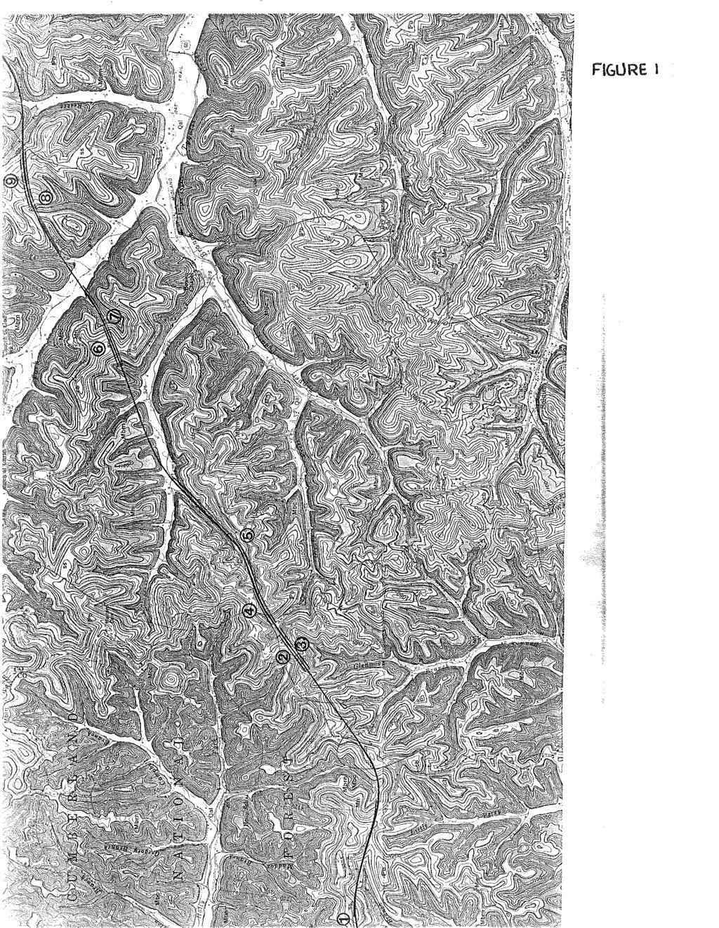
10 FIGIJRE I
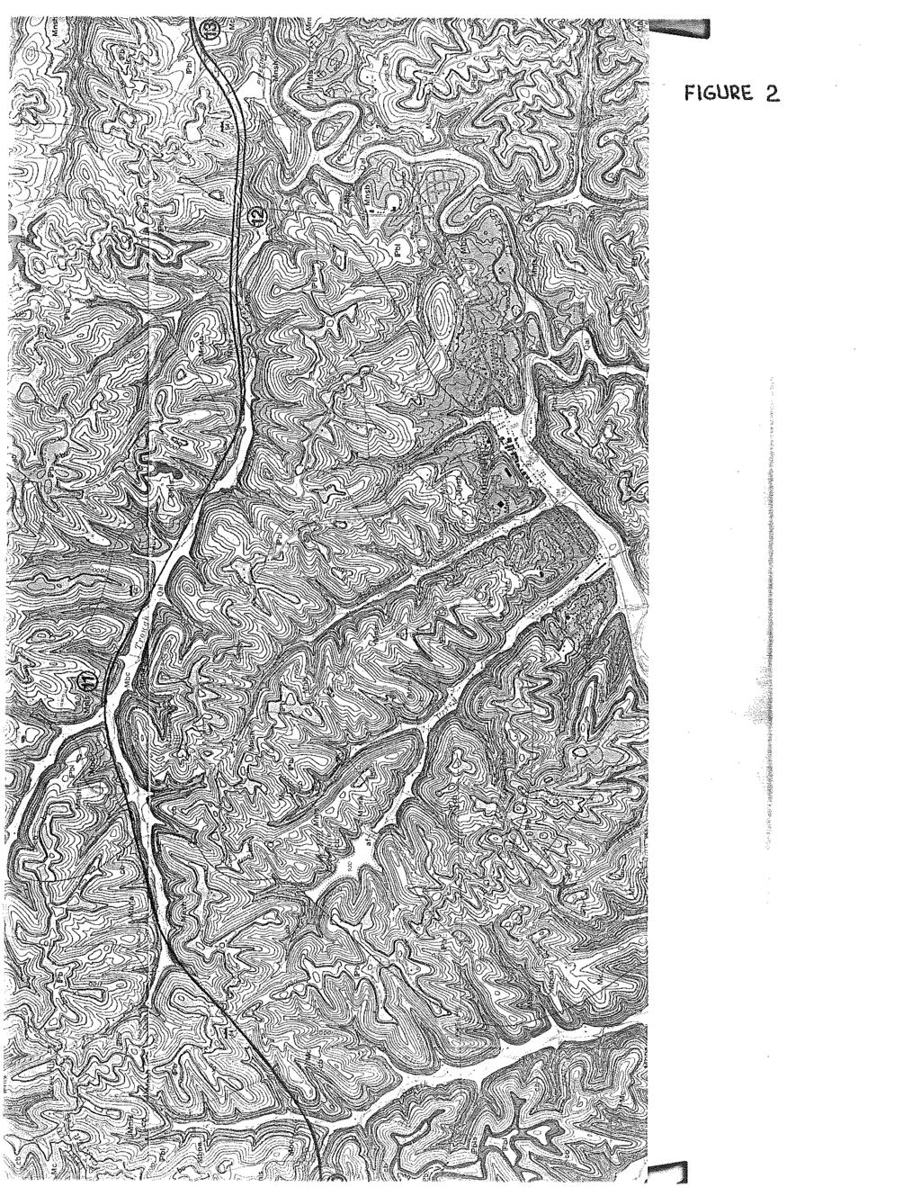
11 FIGURE 2.

12 F\G\JRt. 3
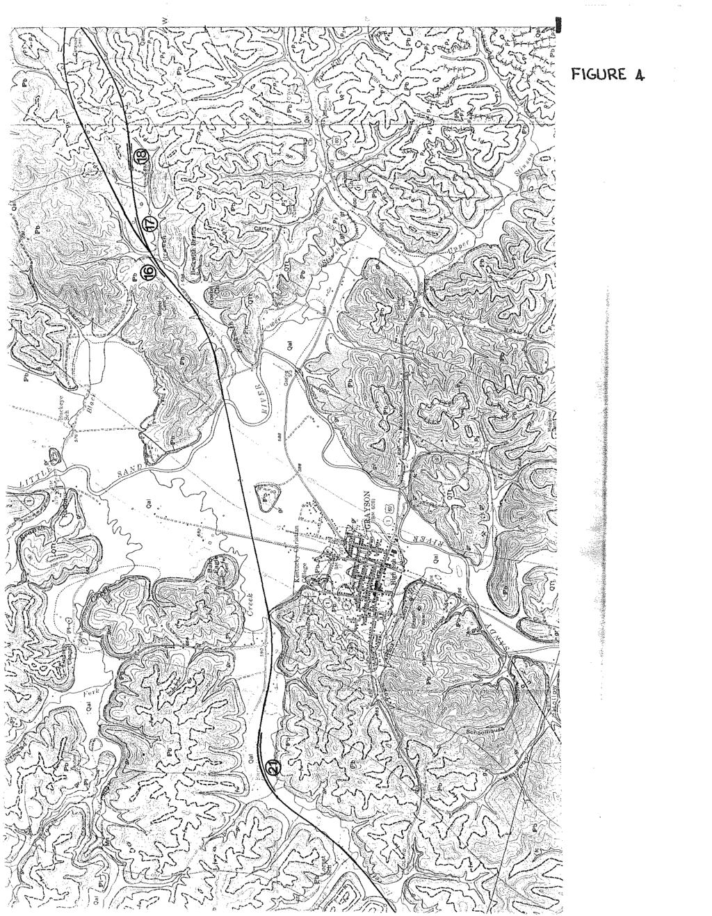
13 F\GUR A.
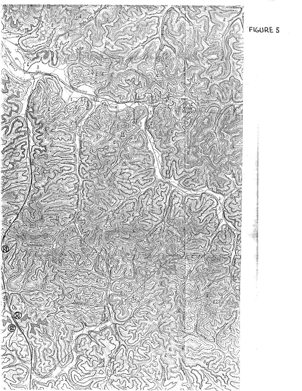
14 .FIGURE 5
Big Rivers Electric Corporation Disposal of Coal Combustion Residuals (CCR) from Electric Utilities Final Rule CCR Impoundment Liner Assessment Report
 from Electric Utilities Final Rule CCR Impoundment Liner Assessment Report") Big Rivers Electric Corporation Disposal of Coal Combustion Residuals (CCR) from Electric Utilities Final Rule CCR Impoundment Liner Assessment Report CCR Surface Impoundment Information Name: Operator:
Big Rivers Electric Corporation Disposal of Coal Combustion Residuals (CCR) from Electric Utilities Final Rule CCR Impoundment Liner Assessment Report CCR Surface Impoundment Information Name: Operator:
The results of KCB s site inspection observations and our recommendations for further work are presented herein.
 July 14, 2015 Central Region 401, 4902 51 Street Red Deer, Alberta T4N 6K8 Mr. Tony Penney, P.Eng. Construction Engineer Dear Mr. Penney: June 25, 2015 Site Inspection Report The above site was visited
CASE STUDY #9 - Brushy Fork Dam, Sugar Grove, West Virginia
 CASE STUDY #9 - Brushy Fork Dam, Sugar Grove, West Virginia Brushy Fork Dam is a flood control structure built by the Soil Conservation Service southeast of the city of Franklin in Pendleton County, West
ENGINEER S CERTIFICATION OF FAULT AREA DEMONSTRATION (40 CFR )
") PLATTE RIVER POWER AUTHORITY RAWHIDE ENERGY STATION BOTTOM ASH TRANSFER (BAT) IMPOUNDMENTS LARIMER COUNTY, CO ENGINEER S CERTIFICATION OF FAULT AREA DEMONSTRATION (40 CFR 257.62) FOR COAL COMBUSTION RESIDUALS
PLATTE RIVER POWER AUTHORITY RAWHIDE ENERGY STATION BOTTOM ASH TRANSFER (BAT) IMPOUNDMENTS LARIMER COUNTY, CO ENGINEER S CERTIFICATION OF FAULT AREA DEMONSTRATION (40 CFR 257.62) FOR COAL COMBUSTION RESIDUALS
KRIS wsbssm. IBHiiilll
 KRIS wsbssm IBHiiilll Digitized by the Internet Archive in 2012 with funding from University of Illinois Urbana-Champaign http://archive.org/details/engineeringaspec34ekbl STATE OF ILLINOIS HENRY HORNER,
1 PROJECT BACKGROUND. August 14, Alberta Transportation Central Region #401, Street Red Deer, Alberta T4N 6K8
 August 14, 2013 Alberta Transportation Central Region #401, 4902 51 Street Red Deer, Alberta T4N 6K8 Mr. Dennis Grace, P.Eng. Construction Engineer Dear Mr. Grace: Central Region Geohazard Assessment 2013
=%REPORT RECONNAISSANCE OF CHISHOLM LAKE PROSPECT. October 25, 1977
 =%REPORT ON FIELD RECONNAISSANCE OF CHISHOLM LAKE PROSPECT October 25, 1977 Bruce D. Vincent Imperial Oil Limited, Minerals - Coal, CALGARY, ALBERTA CHISHOLM LAKE PROSPECT Introduction The Chisholm Lake
NOA ASSESSMENT HARRIS QUARRY MENDOCINO COUNTY, CALIFORNIA TABLE OF CONTENTS
 NOA ASSESSMENT HARRIS QUARRY MENDOCINO COUNTY, CALIFORNIA TABLE OF CONTENTS Introduction... 1 Scope of Services... 1 Project Location and Description... 1 Geologic Setting... 1 Regional Geology... 1 Site
HISTORY OF CONSTRUCTION FOR EXISTING CCR SURFACE IMPOUNDMENT PLANT GASTON ASH POND 40 CFR (c)(1)(i) (xii)
(1)(i) (xii)") HISTORY OF CONSTRUCTION FOR EXISTING CCR SURFACE IMPOUNDMENT PLANT GASTON ASH POND 40 CFR 257.73(c)(1)(i) (xii) (i) Site Name and Ownership Information: Site Name: E.C. Gaston Steam Plant Site Location:
HISTORY OF CONSTRUCTION FOR EXISTING CCR SURFACE IMPOUNDMENT PLANT GASTON ASH POND 40 CFR 257.73(c)(1)(i) (xii) (i) Site Name and Ownership Information: Site Name: E.C. Gaston Steam Plant Site Location:
PRECAMBRIAN CRYSTALLINE AQUIFER (METAMORPHIC ROCKS)
") HAYWARD QUADRANGLE: Groundwater Production by Aquifer In the 56-square-mile area of the Hayward Quadrangle, groundwater is produced from metamorphic crystalline rocks of the Precambrian basement (in the
HAYWARD QUADRANGLE: Groundwater Production by Aquifer In the 56-square-mile area of the Hayward Quadrangle, groundwater is produced from metamorphic crystalline rocks of the Precambrian basement (in the
TRAFFIC ALERT FOR WEEK OF February 4 8, 2008
 TRAFFIC ALERT FOR WEEK OF February 4 8, 2008 Highway work zones in the Staunton District The following is a list of highway work that might affect traffic in the Staunton transportation district during
N. J. Macala. C ONTENT S. LIST OF PLATES.
 REPORT ON WATER SUikLY AT MANBULLOO STATION, NORTHERN TERRITORY. by N. J. Macala. Records 1957/62. C ONTENT S. Page. Introduction. 1. General Geology, 1. Hydrology. 1. New Bore Sites Selected. 2. Reference.
COOMALIE RIDGES RADIOMETRIC SURVEY, RUM JUNGLE AREA,
 COMMONWEALTH OF AUSTRALIA DEPARTMENT OF NATIONAL DEVELOPMENT BUREAU OF MINERAL RESOURCES, GEOLOGY AND GEOPHYSICS RECORD No. 1966/51 500917 COOMALIE RIDGES RADIOMETRIC SURVEY, RUM JUNGLE AREA, NORTHERN
3.12 Geology and Topography Affected Environment
 3 Affected Environment and Environmental Consequences 3.12 Geology and Topography 3.12.1 Affected Environment 3.12.1.1 Earthquakes Sterling Highway MP 45 60 Project Draft SEIS The Kenai Peninsula is predisposed
This report was prepared by Klohn Crippen Consultants Ltd. for Alberta Transportation Central Region under Contract No. CE053/2000.
 Alberta Transportation Central Region #401, 4902 51 Street Red Deer, Alberta T4N 6K8 June 7, 2002 Mr. Melvin Mayfield, P.Eng. Project Engineer Dear Mr. Mayfield: Central Region Landslide Assessment Site
PEACE REGION GRANDE PRAIRIE GEOHAZARD RISK ASSESSMENT SITE INSPECTION FORM NAD 83 COORDINATES N 6,178,811 E 403,309
 PEACE REGION GRANDE PRAIRIE GEOHAZARD RISK ASSESSMENT SITE INSPECTION FORM SITE NUMBER GP-4a LEGAL DESCRIPTION LSD 12-10-78-4-W6M SITE NAME Burnt River Bridge - West Approach Slide HIGHWAY & KM Hwy 49:06
Preliminary Geotechnical Evaluation Gooseberry Point Pedestrian Improvements Whatcom County, Washington SITE AND PROJECT DESCRIPTION
 File No. 12-100 Geotechnical & Earthquake Engineering Consultants Mr. Kevin Brown, P.E. Gray & Osborne, Inc. 3710 168 th Street NE, Suite B210 Arlington, Washington 98223 Subject: Draft Report Preliminary
Geotechnical Aspects of the Ohio River Bridges Project
 Geotechnical Aspects of the Ohio River Bridges Project Mark A. Litkenhus, PE Sr. Geotechnical Engineer Stephen H. Bickel, PE Sr. Geotechnical Engineer STGEC Ohio River Bridges at Louisville Geotechnical
Cretaceous, Dakota Formation, Terra Cotta Member South Side of I-70, Salina County, Kansas
 Cretaceous, Dakota Formation, Terra Cotta Member South Side of I-70, Salina County, Kansas Written By: Steven D.J. Baumann G-102010-1A Outcrop looking southeast Photo taken by: Steven Baumann on 10-20-2010
The Operation of an Electrical Heating System for Bridge Decks
 Transportation Kentucky Transportation Center Research Report University of Kentucky Year 1980 The Operation of an Electrical Heating System for Bridge Decks Wm. Vernon Azevedo Robert C. Deen James H.
SAN JACINTO RIVER / BAUTISTA CREEK LEVEE SYSTEM RIVERSIDE COUNTY, CALIFORNIA NLD ID #
 SAN JACINTO RIVER / BAUTISTA CREEK LEVEE SYSTEM RIVERSIDE COUNTY, CALIFORNIA NLD ID # 3805010019 PERIODIC INSPECTION REPORT NO 1 GENERALIZED EXECUTIVE SUMMARY FEBRUARY 2013 FINAL RATING: MINIMALLY ACCEPTABLE
THE MAMMOTH "EARTHQUAKE FAULT" AND RELATED FEATURES IN MON0 COUNTY, CALIFORNIA* By H. BENIOFF and B. GUTENBERG
 THE MAMMOTH "EARTHQUAKE FAULT" AND RELATED FEATURES IN MON0 COUNTY, CALIFORNIA* By H. BENIOFF and B. GUTENBERG IN UNDERTAKING this work it was our intention to investigate the well-known "Earthquake Fault"
ENGLE COAL FIELD. David E. Tabet
 OPEN FILE REPORT 115 SUMMARY OF THE GEOLOGY OF THE ENGLE COAL FIELD by David E. Tabet THE ENGLE COAL FIELD Introduction The Engle coal field (Lee, 1905), named for the small town of Engle along the Santa
New Jersey Department of Transportation Extreme Weather Asset Management Pilot Study
 New Jersey Department of Transportation Extreme Weather Asset Management Pilot Study Overview Prepared for: June 26, 2018 Introduction Overview of Pilot Study New Jersey s Climate New Jersey s Transportation
Cattaraugus Creek: A Story of Flowing Water and the Geology of the Channel It Flows Through Presentation to West Valley Citizen Task Force 4/27/16
 Cattaraugus Creek: A Story of Flowing Water and the Geology of the Channel It Flows Through Presentation to West Valley Citizen Task Force 4/27/16 Raymond C. Vaughan, Ph.D. What happens if you drop a
Chapter 2. Regional Landscapes and the Hydrologic Cycle
 Chapter 2. Regional Landscapes and the Hydrologic Cycle W. Lee Daniels Department of Crop and Soil Environmental Sciences, Virginia Tech Table of Contents Introduction... 23 Soils and landscapes of the
PENNSYLVANIA DEPARTMENT OF TRANSPORTATION ENGINEERING DISTRICT 3-0
 PENNSYLVANIA DEPARTMENT OF TRANSPORTATION ENGINEERING DISTRICT 3-0 LYCOMING COUNTY S.R.15, SECTION C41 FINAL HYDROLOGIC AND HYDRAULIC REPORT STEAM VALLEY RUN STREAM RELOCATION DATE: June, 2006 REVISED:
3.18 GEOLOGY AND SOILS
 3.18 GEOLOGY AND SOILS This section discusses geologic resource concerns as they relate to the environment, public safety, and project design both during construction and after completion of the project.
West Tennessee Construction June 14-21, 2017
 FOR IMMEDIATE RELEASE Wednesday, June 14, 2017 CONTACT: Nichole Lawrence CELL: 731-225-6041 West Tennessee Construction June 14-21, 2017 BENTON COUNTY, I-40 Truck Climbing Lane Wednesday, June 7 through
Gravel Transport Can Determine Late Flood Tectonics
 Chapter 23 Gravel Transport Can Determine Late Flood Tectonics The locations of all the quartzite gravel in the northwest states and adjacent Canada provide more information about the Flood than just reinforcing
Subject: Desert Palisades Specific Plan - Tram Way Access Sight Distance
 Endo Engineering Traffic Engineering Air Quality Studies Noise Assessments July 13, 2015 Mr. Ed Freeman Pinnacle View, LLC P.O. Box 1754 Lake Oswego, OR 97035-0579 Subject: Desert Palisades Specific Plan
LINGUAU DEPOSITION IN THE WOODBINE SANDS ALONG COPPERAS BRANCH, DENTON COUNTY. TEXAS: A STUDY IN MARINE SEDIMENTATION
 LINGUAU DEPOSITION IN THE WOODBINE SANDS ALONG COPPERAS BRANCH, DENTON COUNTY. TEXAS: A STUDY IN MARINE SEDIMENTATION Ellis W. Shuler and Olin M. Millican The lack of outcrops in three dimensions often
Wells Truck Climbing Lane Elko County
 Wells Truck Climbing Lane Elko County August 23, 2018 STATE OF NEVADA DEPARTMENT OF TRANSPORTATION MATERIALS DIVISION GEOTECHNICAL SECTION GEOTECHNICAL REPORT WELLS TRUCK CLIMBING LANE ELKO COUNTY August
NEEDLES S STREET LEVEE SYSTEM SAN BERNARDINO COUNTY, CALIFORNIA NLD SYSTEM ID #
 SAN BERNARDINO COUNTY, CALIFORNIA NLD SYSTEM ID # 3805030008 PERIODIC INSPECTION REPORT NO. 1 GENERALIZED EXECUTIVE SUMMARY FINAL SYSTEM RATING: MINIMALLY ACCEPTABLE FINAL RATING DATE: AUGUST 2014 PERIODIC
THE BEDROCK SURFACE AND FORMER DRAINAGE SYSTEMS OF MONTGOMERY COUNTY, OHIO 1
 THE BEDROCK SURFACE AND FORMER DRAINAGE SYSTEMS OF MONTGOMERY COUNTY, OHIO 1 STANLEY E. NORRIS, Geologist, U. S. Geological Survey, Columbus, Ohio INTRODUCTION The bedrock surface of Montgomery County,
AN ARCHAEOLOGICAL SURVEY FOR THE EASTHAM STATE PRISON FARM UNIT PROJECT IN HOUSTON COUNTY TEXAS
 AN ARCHAEOLOGICAL SURVEY FOR THE EASTHAM STATE PRISON FARM UNIT PROJECT IN HOUSTON COUNTY TEXAS Antiquities Permit 5693 By William E. Moore and Edward P. Baxter Brazos Valley Research Associates Contract
ENGINEERING EVALUATION OF THE STANLEY MINE ADVENTURE PARK AREA CLEAR CREEK COUNTY, COLORADO. Prepared for:
 braun Braun Consulting Engineers ENGINEERING EVALUATION OF THE STANLEY MINE ADVENTURE PARK AREA CLEAR CREEK COUNTY, COLORADO Prepared for: STANLEY MINES ADENTURE PARK 3375 W. POWERS CIRCLE LITTLETON, COLORADO
SECTION B, GEOlOGY. The Washita River, A Preliminary Report
 SECTION B, GEOlOGY The Washita River, A Preliminary Report ALEX R. ROSS, Department 01 Geology, Oklahoma State Unlverslt, 169 The Geology Department of Oklahoma State University is cooperating with the
patersongroup Mineral Aggregate Assessment 3119 Carp Road Ottawa, Ontario Prepared For Mr. Greg LeBlanc March 7, 2014 Report: PH2223-REP.
 Geotechnical Engineering Environmental Engineering group Hydrogeology Geological Engineering Archaeological Studies Materials Testing 3119 Carp Road Prepared For Mr. Greg LeBlanc March 7, 2014 Paterson
Figure 2.1: Constituent Area
 2 The Region 2.1 CONSTITUENT AREA The National Capital Region includes NCT-Delhi, nine districts of Haryana, six districts of Uttar Pradesh and one district of Rajasthan. Total area of the region is 34,144
AN APPLICATION OF ACID BASE ACCOUNTING FOR HIGHWAY CONSTRUCTION IN EAST TENNESSEE 1
 AN APPLICATION OF ACID BASE ACCOUNTING FOR HIGHWAY CONSTRUCTION IN EAST TENNESSEE 1 by J.T. Ammons C.B. Coburn, Jr. P.A. Shelton 2 Abstract. Concern over the environmental impact of highway construction
February 18, 2003 File: NORTH CENTRAL REGION LANDSLIDE ASSESSMENT HWY 43:16 WHITECOURT EAST HILL (NC1) 2002 ANNUAL INSPECTION REPORT
 2002 ANNUAL INSPECTION REPORT") February 18, 2003 File: 15-76-11 Alberta Transportation Room 223, Provincial Building 4709 44 Avenue Stony Plain, Alberta T7Z 1N4 Attention: Mr. Rob Lonson, P.Eng. NORTH CENTRAL REGION LANDSLIDE ASSESSMENT
February 18, 2003 File: 15-76-11 Alberta Transportation Room 223, Provincial Building 4709 44 Avenue Stony Plain, Alberta T7Z 1N4 Attention: Mr. Rob Lonson, P.Eng. NORTH CENTRAL REGION LANDSLIDE ASSESSMENT
'Published by permission of the director of the U. S. Geological Survey. 330
 SKETCH OF THE GEOLOGY OF THE SALINAS VAL- LEY, CALIFORNIA' IN June and July 19oo, under the direction of Dr. J. C. Branner, Mr. L. D. Mills and the writer undertook to trace out and map the formations
KANSAS GEOLOGICAL SURVEY Open File Report LAND SUBSIDENCE KIOWA COUNTY, KANSAS. May 2, 2007
 KANSAS GEOLOGICAL SURVEY Open File Report 2007-22 LAND SUBSIDENCE KIOWA COUNTY, KANSAS Prepared by Michael T. Dealy L.G., Manager, Wichita Operations SITE LOCATION The site was approximately four miles
Soils, Hydrogeology, and Aquifer Properties. Philip B. Bedient 2006 Rice University
 Soils, Hydrogeology, and Aquifer Properties Philip B. Bedient 2006 Rice University Charbeneau, 2000. Basin Hydrologic Cycle Global Water Supply Distribution 3% of earth s water is fresh - 97% oceans 1%
This material is part of the collection of the Philadelphia Water Department and was downloaded from the website Please contact the
 This material is part of the collection of the Philadelphia Water Department and was downloaded from the website www.phillyh2o.org Please contact the PhillyH2O webmaster for more information about this
R. C. Deen Research Engineer
 Commonwealth of Kentucky Department of Highways KENTUCKY SOILS: THEIR ORIGIN, DISTRIBUTION AND ENGINEERING PROPERTIES by R. C. Deen Research Engineer A Report Presented at the Kentucky Highway Conference,
1.0 INSPECTION ANNUAL INSPECTION, JUNE 29, 2011 CARMACKS COPPER PROJECT, CARMACKS, YUKON. Dear Mr. West-Sells,
 Doc. No. 162 Rev. 0 Mr. Paul West-Sells President & Chief Operating Officer Western Copper Corporation 2060-1111 West Georgia Street Vancouver, BC V6E 4M3 ANNUAL INSPECTION, JUNE 29, 2011 CARMACKS COPPER
SURFACE GEOLOGY AND LIQUEFACTION SUSCEPTIBILITY IN THE INNER RIO GRANDE VALLEY NEAR ALBUQUERQUE, NEW MEXICO
 SURFACE GEOLOGY AND LIQUEFACTION SUSCEPTIBILITY IN THE INNER RIO GRANDE VALLEY NEAR ALBUQUERQUE, NEW MEXICO Keith I. Kelson, Christopher S. Hitchcock, and Carolyn E. Randolph William Lettis & Associates,
ROCK EXCAVATION (GRADING) OPSS 206 INDEX
 OPSS 206 INDEX") 206-2 - OPSS 206 INDEX 206-2.1 GENERAL 206-2.1.1 Classification of Rock Materials 206-2.1.2 Tender Items 206-2.1.3 Other Excavation Tender Items 206-2.1.4 Specifications 206-2.1.5 Special Provisions 206-2.1.6
206-2 - OPSS 206 INDEX 206-2.1 GENERAL 206-2.1.1 Classification of Rock Materials 206-2.1.2 Tender Items 206-2.1.3 Other Excavation Tender Items 206-2.1.4 Specifications 206-2.1.5 Special Provisions 206-2.1.6
720 Land Conditions Comprehensive Plan Section 720
 721 720 omprehensive Plan Section 720 REGIONAL SETTING Owensboro is located on the Ohio River, in the western part of the state of Kentucky. According to Housing Market Analysis, Owensboro s regional relationship
Betsy Stevenson and Allison Mohrs (Skagit County Planning and Development Services) Jenny Baker, The Nature Conservancy
 Jenny Baker, The Nature Conservancy") TC Fisher Slough Final Design and Permitting Subject: Well Review Memorandum To: From: Betsy Stevenson and Allison Mohrs (Skagit County Planning and Development Services) Jenny Baker, The ature Conservancy
TC Fisher Slough Final Design and Permitting Subject: Well Review Memorandum To: From: Betsy Stevenson and Allison Mohrs (Skagit County Planning and Development Services) Jenny Baker, The ature Conservancy
Converse Consultants Geotechnical Engineering, Environmental & Groundwater Science, Inspection & Testing Services
 Converse Consultants Geotechnical Engineering, Environmental & Groundwater Science, Inspection & Testing Services July 27, 2017 Ms. Rebecca Mitchell Mt. San Antonio College Facilities Planning & Management
Geology 12 FINAL EXAM PREP. Possible Written Response Exam Questions
 Geology 12 FINAL EXAM PREP Possible Written Response Exam Questions Use this study guide to prepare for the written response portion of the final exam. Name FINAL EXAM - POSSIBLE WRITTEN RESPONSE QUESTIONS
Observations on Surface Water in the Seminary Fen in Spring, Prepared 6/4/13 by Sam Wetterlin; updated 7/28/13
 Observations on Surface Water in the Seminary Fen in Spring, 2013 Prepared 6/4/13 by Sam Wetterlin; updated 7/28/13 Ordinarily, a calcareous fen is primarily dependent on upwelling mineral-rich, oxygen-poor
SEISMIC REFRACTION SURVEY RIPPABILITY STUDY
 SEISMIC REFRACTION SURVEY RIPPABILITY STUDY US 95A SILVER SPRINGS to FERNLEY LYON COUNTY August 2008 E.A. 73455 MATERIALS DIVISION SEISMIC REFRACTION SURVEY RIPPABILITY STUDY LYON COUNTY US 95A SILVER
LONG-TERM MOVEMENTS OF HIGHWAY BRIDGE APPROACH EMBANKMENTS AND PAVMENTS
 LONG-TERM MOVEMENTS OF HIGHWAY BRIDGE APPROACH EMBANKMENTS AND PAVMENTS Tommy C. Hopkins Research Engineer University of Kentucky Transportation Center Geotechnology 8 TH ANNUAL TECHNICAL FORUM GEOHAZARDS
Use of Launched Soil Nails to Stabilize Landslides in Summit County, Ohio
 Use of Launched Soil Nails to Stabilize Landslides in Summit County, Ohio Mitchell W. Weber, P.G. Gannett Fleming Engineers & Architects, P.C. Greg Bachman, P.E., P.S. County of Summit Engineer Robert
Seismic Data and Drilling in Hancock Co., Kentucky February 21, 2008
 Seismic Data and Drilling in Hancock Co., Kentucky February 21, 2008 J.A. Drahovzal 2/21/08 1 Hancock County (H1) Information Provided at 2/7/08 Meeting Depth of Top (t) and Thickness (th) in feet t Kn
Page 1. Name:
 Name: 1) Which event is the best example of erosion? dissolving of rock particles on a limestone gravestone by acid rain breaking apart of shale as a result of water freezing in a crack rolling of a pebble
Rock & Aggregate Drop Inlet Protection
 Rock & Aggregate Drop Inlet Protection SEDIMENT CONTROL TECHNIQUE Type 1 System Sheet Flow Sandy Soils Type 2 System [1] Concentrated Flow Clayey Soils Type 3 System Supplementary Trap Dispersive Soils
Mountain Valley Pipeline, LLC Mountain Valley Pipeline Project FERC Docket No. CP
 Mountain Valley Pipeline, LLC Mountain Valley Pipeline Project FERC Docket No. CP16-10-000 Attachment 64 Site-specific Water Crossing and Restoration Plans Mountain Valley Pipeline, LLC Mountain
The last three sections of the main body of this report consist of:
 Threatened and Endangered Species Geological Hazards Floodplains Cultural Resources Hazardous Materials A Cost Analysis section that provides comparative conceptual-level costs follows the Environmental
4.3. Geomorphologic route along the Urasalakh River
 The Expedition Lena-Anabar 2003 4 Periglacial studies around Cape Mamontov Klyk 4.3. Geomorphologic route along the Urasalakh River Dimitri Bolshiyanov and Alexander Makarov 4.3.1 Structure of Quaternary
Grade 5 Hands on Science Weathering, Erosion and Deposition
 Grade 5 Hands on Science Weathering, Erosion and Deposition Objective: To demonstrate and investigate the effect of weathering, water and wind erosion and the subsequent deposition into landforms. Background:
Seismic Reflection Imaging across the Johnson Ranch, Valley County, Idaho
 Seismic Reflection Imaging across the Johnson Ranch, Valley County, Idaho Report Prepared for the Skyline Corporation Lee M. Liberty Center for Geophysical Investigation of the Shallow Subsurface (CGISS)
LEGEND ODOT CLASS. A-4b. A-6a. A-6b TOTAL VISUAL WEATHERED SANDSTONE VISUAL BORING LOCATION - PLAN VIEW
 PROJECT THE PROJECT CONSISTS IN PART OF ACING TWO STRUCTURES, EASTBOUND AND WESTBOUND STRUCTURES, RESPECTIVELY FOR THE PROPOSED SR OVER BLUE ROAD (CR 9). THE TWO STRUCTURES AS ANNED, ARE SINGLE-SPAN STRUCTURES
4.5 GEOLOGY AND SOILS
 4.5 GEOLOGY AND SOILS This section addresses the project site geology and soils and analyzes potential changes that would result from development of the Wye Specific Plan project. 4.5.1 Environmental Setting
QUINTETTE COAL LIMITED 1979 EXPLORATION ASSESSMENT REPORT
 QUINTETTE COAL LIMITED 1979 EXPLORATION ASSESSMENT REPORT JANUARY 1980 TABLE OF CONTENTS 1.0 Introduction 1.1 Geological Mapping 1.2 Field Camp 2.0 Geology 2.1 Introduction 2.2 Stratigraphy 2.3 Structure
Stromatoporoids around the Georgetown, Kentucky area
 Stromatoporoids around the Georgetown, Kentucky area If you have ever visited and / or travelled around the area of Georgetown, Scott County, Kentucky you might have noted white watermelon shaped rocks
City of Saginaw Right of Way Division Snow and Ice Removal Policy January 18, 2016
 Snow and Ice Removal Policy January 18, 2016 It is the policy of the to provide snowplowing and ice removal services in order to: Provide safe traveling conditions for motorists and pedestrians Assist
An Inventory of Granular Materials in Indiana
 An Inventory of Granular Materials in Indiana J ean E. Hittle Research Engineer, Joint Highway Research Project Purdue University Of the many improvements in the design of highway pavements during the
Name: Which rock layers appear to be most resistant to weathering? A) A, C, and E B) B and D
 A, C, and E B) B and D") Name: 1) The formation of soil is primarily the result of A) stream deposition and runoff B) precipitation and wind erosion C) stream erosion and mass movement D) weathering and biological activity 2)
Name: 1) The formation of soil is primarily the result of A) stream deposition and runoff B) precipitation and wind erosion C) stream erosion and mass movement D) weathering and biological activity 2)
Name: Mid-Year Review #2 SAR
 Name: Mid-Year Review #2 SAR Base your answers to questions 1 through 3 on on the diagram below, which shows laboratory materials used for an investigation of the effects of sediment size on permeability,
Information Pamphlet 8 WATER LEVELS IN THE UPPER WEST BENCH ALLUVIAL AQUIFER, RED LODGE, MONTANA
 Ground Water Assessment Program Information Pamphlet 8 WATER LEVELS IN THE UPPER WEST BENCH ALLUVIAL AQUIFER, RED LODGE, MONTANA Camela Carstarphen, Thomas Patton, and John I. LaFave View of Remington
Rockwood Embankment Slide Between Stations and : A Horizontal Drain Case History
 26 Transportation Research Record 783 Rockwood Embankment Slide Between Stations 21+ and 218+: A Horizontal Drain Case History WLLAM D. TROLNGER The most troublesome interval in regard to landslides on
The subject paper is being submitted for approval for publication in the annual volume entitled Geological Survey Research.
 Water Resources Division 345 Middlefield Road Menlo Park, California January 12, 1965 Memorandum To: Mr. Frank E. Clark, Chief, General Hydrology Branch Thru: Area Hydrologist PCA From: Valmore C. LaMarche
Wisconsin s Hydrogeology: an overview
 2012 Soil and Water Conservation Society Conference Stevens Point, WI Feb 9, 2012 Wisconsin s Hydrogeology: an overview Ken Bradbury Wisconsin Geological and Natural History Survey University of Wisconsin-Extension
1. Base your answer to the following question on the map below, which shows the generalized bedrock of a part of western New York State.
 1. Base your answer to the following question on the map below, which shows the generalized bedrock of a part of western New York State. 3. The table below describes the deposits that an observer saw while
Road Scholar. Williamette Valley Invitational Practice Tournament
 Road Scholar Williamette Valley Invitational Practice Tournament Rules for this Event As you complete this event, enter your answers on the online data sheet. You may click "submit" when done and quietly
2. PHYSICAL SETTING FINAL GROUNDWATER MANAGEMENT PLAN. 2.1 Topography. 2.2 Climate
 FINAL GROUNDWATER MANAGEMENT PLAN 2. PHYSICAL SETTING Lassen County is a topographically diverse area at the confluence of the Cascade Range, Modoc Plateau, Sierra Nevada and Basin and Range geologic provinces.
FIGURE 1 Example schematic of flagging model. Study Design and Results
 DEER-FLAGGING MODELS Some experts believe that white-tailed deer raise their tails to expose their white undersurface as a warning communication between their species. One study was found that evaluated
Karst Sub-basin Delineation via Dye Trace Study near Turnhole Bend, Mammoth Cave National Park
 Western Michigan University ScholarWorks at WMU Honors Theses Lee Honors College 4-18-2017 Karst Sub-basin Delineation via Dye Trace Study near Turnhole Bend, Mammoth Cave National Park Jake Tholen Western
When Creek Meets Valley Wall: Prioritizing Erosion Mitigation alongside the Oshawa Landfill
 1 When Creek Meets Valley Wall: Prioritizing Erosion Mitigation alongside the Oshawa Landfill Robin McKillop 1, Dan McParland 1 & Cassie Scobie 2 TRIECA conference March 22-23, 2017 1 Palmer Environmental
Materials. Use materials meeting the following.
 208.01 Section 208. SOIL EROSION AND SEDIMENTATION CONTROL 208.01 Description. Install and maintain erosion and sedimentation controls to minimize soil erosion and to control sedimentation from affecting
BUREAU OF MINERAL RESOURCES GEOLOGY AND GEOPHYSICS
 COMMONWEALTH OF AUSTRALIA DEPARTMENT OF NATIONAL DEVELOPMENT BUREAU OF MINERAL RESOURCES GEOLOGY AND GEOPHYSICS RECORDS: 1 9 67/77 PHOTO-INTERPRETATION OF BURKETOWN 1:250,000 SCALE SHEET QUEENSLAND. by
PENNSYLVANIA DEPARTMENT OF TRANSPORTATION DISTRICT 6-0 HYDROLOGIC AND HYDRAULIC REPORT. for SR 3062, SECTION 29S STRASBURG ROAD.
 PENNSYLVANIA DEPARTMENT OF TRANSPORTATION DISTRICT 6-0 HYDROLOGIC AND HYDRAULIC REPORT for SR 3062, SECTION 29S STRASBURG ROAD over WEST BRANCH OF BRANDYWINE CREEK EAST FALLOWFIELD TOWNSHIP, CHESTER COUNTY
LITHOLOGIC FACIES OF A PORTION OF THE STILLWATER FORMATION DON B. GOULD
 118 PROCEEDINGS OF THE OKLAHOMA a LITHOLOGIC FACIES OF A PORTION OF THE STILLWATER FORMATION DON B. GOULD University of Iowa, Iowa City, Iowa The Permian rocks of the world are noted for their unusual
Background. Valley fills Sites in the Area. Construction over Mine Spoil Fills
 Construction over Mine Spoil Fills Wayne A. Karem, PhD, PE, PG, D.GE 2014 KSPE Annual Conference Background Strip mining; mountaintop and contour mining Creates huge quantities of mine spoil The mine spoil
GEOLOGICAL BRANCH ASSESSMENT REPORT 12. FItE NO: ACTION: THE GOLDEN MINING DIVISION, GOLDEN, Including THE NTS MAP; M82K/15W
 ACTION: FItE NO: Including 1990 GEO-CHEM SURVEY RESULTS -- THE AVD CLAIMS - THE GOLDEN MINING DIVISION, GOLDEN, B.C. NTS MAP; M82K/15W Lat. 50 deg. 55 Min. Long 116 deg. 55 min. For GEOLOGICAL BRANCH ASSESSMENT
Field Trip Workbook G200 Field Studies Sec 001 (Mt St. Helens north) Fall, 2018 Professor in charge: Alex Ruzicka TA : Secana Goudy
 Fall, 2018 Professor in charge: Alex Ruzicka TA : Secana Goudy") Field Trip Workbook NAME: G200 Field Studies Sec 001 (Mt St. Helens north) Fall, 2018 Professor in charge: Alex Ruzicka TA : Secana Goudy Use this workbook to answer the following questions about the geology
Field Trip Workbook NAME: G200 Field Studies Sec 001 (Mt St. Helens north) Fall, 2018 Professor in charge: Alex Ruzicka TA : Secana Goudy Use this workbook to answer the following questions about the geology
January 12, 2006 File:
 January 12, 2006 File: 15-85-13 Alberta Infrastructure and Transportation Room 301, Provincial Building 9621-96 Avenue Peace River, Alberta T8S 1T4 Attention: Mr. Ed Szmata PEACE REGION (PEACE HIGH LEVEL
Commonwealth of Pennsylvania PA Test Method No. 729 Department of Transportation October Pages LABORATORY TESTING SECTION. Method of Test for
 Commonwealth of Pennsylvania PA Test Method No. 729 Department of Transportation 14 Pages LABORATORY TESTING SECTION Method of Test for SAMPLING ROADWAY BITUMINOUS CONCRETE 1. SCOPE 1.1 This method covers
Locating and Tracing Seepage Water in Unstable Slopes
 Transportation Kentucky Transportation Center Research Report University of Kentucky Year 197 Locating and Tracing Seepage Water in Unstable Slopes Yasin A. Alkhoja Gordon D. Scott Kentucky Department
BUREAU OF MINERAL RESOURCES GEOLOGY AND GEOPHYSICS.
 Copy for Chief Geophysioira COMMONWEALTH OF AUSTRALIA. DEPARTMENT OF NATIONAL DEVELOPMENT. BUREAU OF MINERAL RESOURCES GEOLOGY AND GEOPHYSICS. RECORDS. 196 2/25 REPORT ON KUMBRUF GOLD PROSPECT MADANGDISTRICT,
PROSPECTING REPORT. Deneau Creek. EVENT # TENURE # Tenure Name: Deneau Creek. New Westminster Mining Division Map 092H
 2010-2011 PROSPECTING REPORT Deneau Creek EVENT # 4844921 TENURE # 578616 Tenure Name: Deneau Creek New Westminster Mining Division Map 092H Central Coordinate Reference 121 18 04.5 W Longitude 49 26 13.9
American Institute of Professional Geologists South Dakota Section
 American Institute of Professional Geologists South Dakota Section 2015 Field Trip Guide Deadwood Formation in the Black Hills of South Dakota and Frac Sand Potential Saturday, September 12, 2015 1 Field
Geosynthetics Applications and Performance Reviews Select Case Histories
 Geosynthetics Applications and Performance Reviews Select Case Histories Debora J. Miller, Ph.D., P.E.; Dean B. Durkee,, Ph.D., P.E.; Michael A. Morrison, P.E., David B. Wilson, P.E., and Kevin Smith,
Submitted for Presentation at the 2006 TRB Annual Meeting of the Transportation Research Board
 Investigation of Hot Mix Asphalt Surfaced Pavements Skid Resistance in Maryland State Highway Network System By Wenbing Song, Xin Chen, Timothy Smith, and Adel Hedfi Wenbing Song MDSHA, Office of Material
GIFFORD PINCHOT STATE PARK DIABASE (MOLTEN LIQUID ROCK)
") PENNSYLVANIA TRAIL OF GEOLOGY PARK GUIDE 10 GIFFORD PINCHOT STATE PARK DIABASE (MOLTEN LIQUID ROCK) Gifford Pinchot State Park contains examples of the three major rock classes: igneous, metamorphic, and
PENNSYLVANIA TRAIL OF GEOLOGY PARK GUIDE 10 GIFFORD PINCHOT STATE PARK DIABASE (MOLTEN LIQUID ROCK) Gifford Pinchot State Park contains examples of the three major rock classes: igneous, metamorphic, and