SEISMIC REFRACTION SURVEY RIPPABILITY STUDY
|
|
|
- Arthur Samson Greene
- 6 years ago
- Views:
Transcription


1 SEISMIC REFRACTION SURVEY RIPPABILITY STUDY US 95A SILVER SPRINGS to FERNLEY LYON COUNTY August 2008 E.A MATERIALS DIVISION
2 SEISMIC REFRACTION SURVEY RIPPABILITY STUDY LYON COUNTY US 95A SILVER SPRINGS to FERNLEY Milepost LY to Milepost LY August 2008 E.A Prepared by: Dana Boomhower Senior Materials Engineer - Geotechnical Reviewed by: Jeff Palmer, Ph.D., P.E. Principal Geotechnical Engineer Approved by: Reid Kaiser, P.E. Chief Materials Engineer
3 TABLE OF CONTENTS GENERAL... 1 PURPOSE and SCOPE... 1 PROJECT DESCRIPTION... 1 GEOLOGY of the SLOPES... 2 SEISMIC EQUIPMENT and FIELD PROCEDURE... 2 FIELD SEISMOGRAPH RECORDS... 2 RESULTS... 3 LIMITATIONS... 3 REFERENCES... 4 APPENDICES APPENDIX A...Velocity Charts APPENDIX B...Seismograph Readout Strips
4 SEISMIC REFRACTION SURVEY General During the month of July 2006, the NDOT Geotechnical Section conducted surface seismic refraction survey on three separate rock cuts along highway US 95A, north of Silver Springs (US 50), between milepost LY and milepost LY 46.00, in Lyon County, Nevada. Five runs were performed on area FSS-1 on the east side of US-95A; two south to north, one center, and two north to south. The geophone line was strung horizontally across the cut slope face at 15-foot spacing in a north-south orientation, at approximately Station P , 110 feet right, to P , 90 feet right. Three runs were performed on area FSS-3 on the east side of US-95A; one each south to north, center, and north to south. The geophone line was strung at 20-foot spacing across the slope face in a north-south orientation, at approximately Station P , 130 feet right, to P , 120 feet right. Three runs were performed on area FSS-4 on the west side of US-95A; one each south to north, center, and north to south. The geophone line was strung at 10-foot spacing along the west side of the old roadway in a north-south orientation, at approximately Station P , 120 feet left, to P , 110 feet left. Purpose and Scope The purpose of this survey investigation was to provide information regarding the rippability of the rocks in the existing rock cuts, utilizing seismic refraction techniques. The scope of this investigation included site reconnaissance, research of available geologic literature pertaining to the site, conducting surface seismic refraction survey, and report preparation. Project Description This section of the roadway was built under NDOT Contract Nos. 592 and 624 in 1940 and NDOT is planning to flatten slopes and install guardrail on both sides of the roadway between mileposts LY and LY on US 95A. The NDOT Roadway Design Division 1
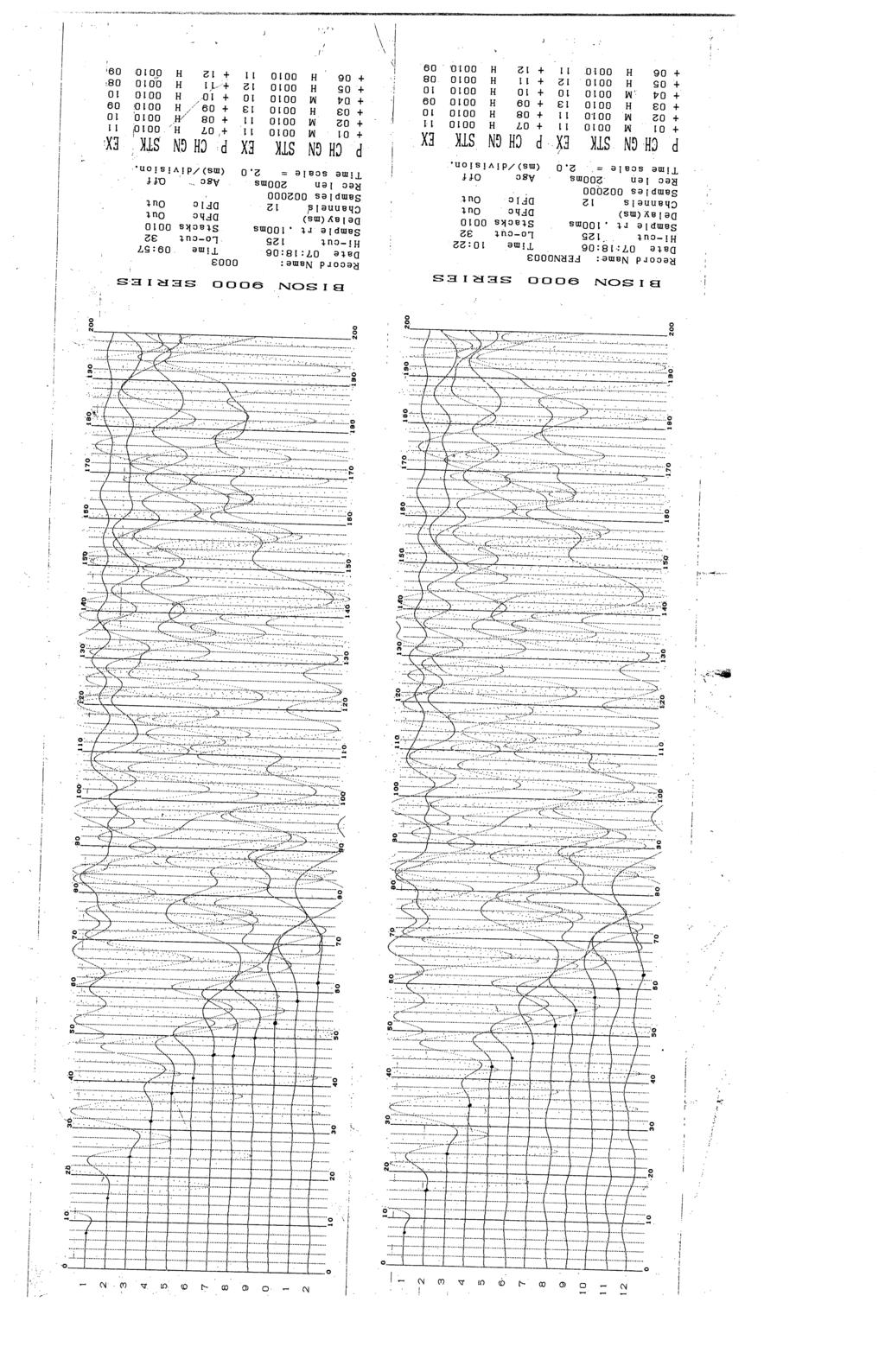
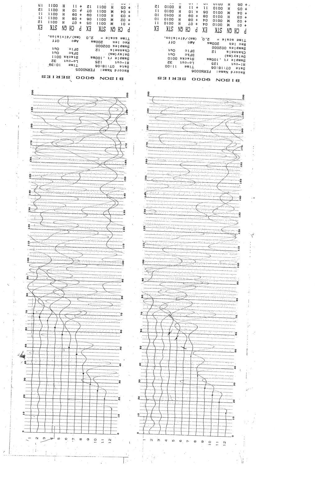
5 requested information regarding rippability of rock slopes in the project area to provide material for the slope widening. These rock cuts are located between milepost LY and milepost LY Geology of the Slopes The slopes are primarily igneous rock (basalt). The degree of weathering varies across each individual slope. Spacing of joint sets at different locations varies widely from one millimeter to a several millimeters. Most joints are filled with fine sand and silt. Photographs of the slopes are included in the Appendix. Seismic Equipment and Field Procedures A Bison Series channel seismograph was used to collect seismic refraction data. The geophones were planted at 10-foot, 15-foot, and 20-foot intervals on the face of the slopes, in generally the north-south direction, and parallel to the highway alignment. A sledge-hammer and metal striking plate were used to generate the energy source. The layout for the seismic work included series of forward and reversed seismic lines reversed-profile shooting with the striking plate at a distance equal to the spacing of the geophones from the end-geophones, or equidistant from the middle geophones. The signals received by the geophones were digitized by the seismograph equipped with signal enhancement. The signals were stacked 10 times for each seismic line. Field Seismograph Records The field seismograph records contain data representing the time it takes for compressional energy (P-wave) generated by the seismic source to travel a path through the subsurface and back up to the geophones on the surface. The first arrival of compressional energy including first point of movement or point of maximum curvature at each geophone is marked on the enclosed Bison Series charts and was used to determine the position of refracting surfaces. Arrival times versus shotpoint-to-geophone distance (Time-Distance) were plotted manually. The slopes of these time-distance segments are inversely proportional to the apparent velocity of sound in that layer of the Earth. The time-distance plots of data obtained from the seismograph records are included in Appendix A. 2
6 Results The time-distance plot is an interpretation of the seismograph records to obtain an approximate evaluation of the state of rippability of the rock slopes. The velocities on the time-distance plots can be compared with charts relating rippability to seismic velocity in rock. One example of a chart such as this is the Caterpillar Tractor Company Ripper Performance Charts. These charts help to determine difficulties that may be encountered in the excavation of rock slopes. There are possibly more massive rocks with fewer or less continuous joints at depth in the slopes that could be more difficult to excavate. Limitations Because of the inherent limitation in the seismic refraction method, the seismic survey alone can not be considered definitive in evaluating rock slope rippability. Drilling or coring with a drill rig and/or the excavation of test trenches with a bulldozer with ripper or backhoe may be required to provide additional information regarding rippability of the rock slopes at this site. 3
7 References Dobrin, M.B., 1976, Introduction to Geophysical Prospecting (3rd ed.): New York, McGraw- Hill. U.S. Department of the Interior, Application of Seismic-Refraction Techniques to Hydrologic Studies, 1988, United States Government Printing Office, Washington. Department of the Army Corps of Engineers, Geophysical Exploration, 1979, Engineering Manual, EM Blaricom Richard, Practical Geophysics, 1980, Northwest Mining Association, Spokane, WA. 4
8 APPENDIX A VELOCITY CHARTS
9 FSS TIME (Milliseconds) RUN 1 RUN 2 RUN 4 RUN 3 RUN DISTANCE (Feet)
10 FSS-3 TIME (Milliseconds) RUN 1 RUN 2 RUN DISTANCE (Feet0
11 FSS-4 60 TIME (Milliseconds) RUN 1 RUN 2 RUN DISTANCE (Feet)
12 APPENDIX B SEISMOGRAPH READOUT STRIPS
13
14
15
16
17
18
19
20
21
22 APPENDIX C PHOTOGRAPHS

23 Slope FSS-1 Slope FSS-3

24 Slope FSS-4
Rock Scaling Recommendations Logan Creek Drive Cut Slope
 Rock Scaling Recommendations Logan Creek Drive Cut Slope US 50, Milepost DO 8.47 to DO 8.61 Douglas County, Nevada January 2008 MATERIALS DIVISION STATE OF NEVADA DEPARTMENT OF TRANSPORTATION MATERIALS
DEPTH AND VELOCITY ESTIMATES FROM SEISMIC WAVES REFRACTION PATHS AT EBONYI STATE UNIVERSITY STAFF SCHOOL, ABAKALIKI, NIGERIA ABSTRACT
 DEPTH AND VELOCITY ESTIMATES FROM SEISMIC WAVES REFRACTION PATHS AT EBONYI STATE UNIVERSITY STAFF SCHOOL, ABAKALIKI, NIGERIA Agha, S. O. Dept. of Industrial Physics Ebonyi State University Abakaliki, NIGERIA
COMMONWEALTH OF AUSTRALIA RECORD NO. 1962/180 QUEEN VICTORIA HOSPITAL SITE SEISMIC SURVEY, LAUN CESTON TASMANIA 1961 E. J. POLAK
 COMMONWEALTH OF AUSTRALIA DEPA T:11/ICEj\IT OF NATIONAL DEVELOPMENT BUIEcAlPeF MINERAL RESOURCES, GEOLOGY AND GEOPHYSICS t 43 0,f,k. 11 RECORD NO. 1962/180 QUEEN VICTORIA HOSPITAL SITE SEISMIC SURVEY,
Geophysical Site Investigation (Seismic methods) Amit Prashant Indian Institute of Technology Gandhinagar
 Amit Prashant Indian Institute of Technology Gandhinagar") Geophysical Site Investigation (Seismic methods) Amit Prashant Indian Institute of Technology Gandhinagar Short Course on Geotechnical Aspects of Earthquake Engineering 04 08 March, 2013 Seismic Waves
Geophysical Site Investigation (Seismic methods) Amit Prashant Indian Institute of Technology Gandhinagar Short Course on Geotechnical Aspects of Earthquake Engineering 04 08 March, 2013 Seismic Waves
Determination of Incompressibility, Elasticity and the Rigidity of Surface Soils and Shallow Sediments from Seismic Wave Velocities
 Journal of Earth Sciences and Geotechnical Engineering, vol. 6, no.1, 2016, 99-111 ISSN: 1792-9040 (print), 1792-9660 (online) Scienpress Ltd, 2016 Determination of Incompressibility, Elasticity and the
An Introduction to Field Explorations for Foundations
 An Introduction to Field Explorations for Foundations J. Paul Guyer, P.E., R.A. Paul Guyer is a registered mechanical engineer, civil engineer, fire protection engineer and architect with over 35 years
EFFECTS OF LOCAL METEOROLOGICAL VARIABILITY ON SURFACE AND SUBSURFACE SEISMIC-ACOUSTIC SIGNALS
 EFFECTS OF LOCAL METEOROLOGICAL VARIABILITY ON SURFACE AND SUBSURFACE SEISMIC-ACOUSTIC SIGNALS Jason R. McKenna and Mihan H. McKenna U.S. Army Engineer Research & Development Center, Vicksburg, MS 39180
LECTURE 10. Module 3 : Field Tests in Rock 3.6 GEOPHYSICAL INVESTIGATION
 LECTURE 10 3.6 GEOPHYSICAL INVESTIGATION In geophysical methods of site investigation, the application of the principles of physics are used to the study of the ground. The soil/rock have different characteristics
FINAL REPORT GEOPHYSICAL INVESTIGATION WATER TOWER NO. 6 SITE PLANT CITY, FL
 APPENDIX B FINAL REPORT GEOPHYSICAL INVESTIGATION WATER TOWER NO. 6 SITE PLANT CITY, FL Prepared for Madrid Engineering Group, Inc. Bartow, FL Prepared by GeoView, Inc. St. Petersburg, FL February 28,
Ground-Water Exploration in the Worthington Area of Nobles County: Summary of Seismic Data and Recent Test Drilling Results
 Ground-Water Exploration in the Worthington Area of Nobles County: Summary of Seismic Data and Recent Test Drilling Results Jim Berg and Todd Petersen Geophysicists, DNR Waters January 2000 Table of Contents
SEISMIC SURVEY METHODS
 SEISMIC SURVEY METHODS Seismic methods Seismic surveys are used in geology and geotechnical engineering to: a) define the depth of the bedrock; b) investigate the landslide areas, c) check the structural
C13^COMMONWEALTH OF AUSTRALIA
 tal C13^COMMONWEALTH OF AUSTRALIA DEPARTMENT OF NATIONAL DEVELOPMENT BUREAU OF MINERAL RESOURCES, GEOLOGY AND GEOPHYSICS 44 1 NE/41 RECORD No. 1963/22 l^' it Ril R y#11, 1 zz^g M^ P3 C3 rn 00 GEOPHYSICAL
Seismoelectric Ground-flow DC-4500 Locator
 Seismoelectric Ground-flow DC-4500 Locator Introduction The seismoelectric survey is a new technology combined the electro kinetic potential method and geophysical technology. It is applied directly to
Appendix B: Geophysical Data (Thesis Appendix, 2013)
") Utah State University From the SelectedWorks of David J Richey 2013 Appendix B: Geophysical Data (Thesis Appendix, 2013) David J Richey, Utah State University Available at: https://works.bepress.com/david_richey/2/
Utah State University From the SelectedWorks of David J Richey 2013 Appendix B: Geophysical Data (Thesis Appendix, 2013) David J Richey, Utah State University Available at: https://works.bepress.com/david_richey/2/
MAPPING BEDROCK: Verifying Depth to Bedrock in Calumet County using Seismic Refraction
 MAPPING BEDROCK: Verifying Depth to Bedrock in Calumet County using Seismic Refraction Revised December 13, 2011 Dave Hart Wisconsin Geological and Natural History Survey INTRODUCTION Seismic refraction
Record 1912/43 WODEN TRUNK SEWER EXTENSION SEISMIC REFRACTION INVESTIGATION, ACT, by. G.R. Pettifer
 , J il >,,. (, i-, BMR Record 1972143 c.3 COiViMOi\lWEALTH OF AUSTRALA [D)lE~A[RnrM lent (Q)~ NAT~(Q)N~[l [D)lEV[E[l(Q)~M[ENT rns(uj[rs~~qjj @~ UWiJO~~~~[L ~~~@(UJ[RS ~~a@~@[l @W ~~[Q) @~@~[}={]W~O ~ Record
KARST MAPPING WITH GEOPHYSICS AT MYSTERY CAVE STATE PARK, MINNESOTA
 KARST MAPPING WITH GEOPHYSICS AT MYSTERY CAVE STATE PARK, MINNESOTA By Todd A. Petersen and James A. Berg Geophysics Program Ground Water and Climatology Section DNR Waters June 2001 1.0 Summary A new
Geophysical Investigation of Ground Water Using Vertical Electrical Sounding and Seismic Refraction Methods
 International Journal of Petroleum and Petrochemical Engineering (IJPPE) Volume 2, Issue 1, 2016, PP 6-11 ISSN 2454-7980 (Online) www.arcjournals.org Geophysical Investigation of Ground Water Using Vertical
Acquisition and preliminary analysis of the Castle Mountain shallow VSP dataset
 Castle Mountain shallow VSP Acquisition and preliminary analysis of the Castle Mountain shallow VSP dataset Joe Wong, Henry C. Bland, Kevin W. Hall and Robert R. Stewart ABSTRACT As part of the 2006 geophysics
Wells Truck Climbing Lane Elko County
 Wells Truck Climbing Lane Elko County August 23, 2018 STATE OF NEVADA DEPARTMENT OF TRANSPORTATION MATERIALS DIVISION GEOTECHNICAL SECTION GEOTECHNICAL REPORT WELLS TRUCK CLIMBING LANE ELKO COUNTY August
Formation Stratigraphy and Interfingering at the Port of Miami
 Formation Stratigraphy and Interfingering at the Port of Miami AUGUST 6, 2012 PROJECT PARTNERS Public Sponsors 90% Equity Partner Contractor 10% Equity Partner VMS Operator Federal Support FUNDING PARTNERS
Lima Project: Seismic Refraction and Resistivity Survey. Alten du Plessis Global Geophysical
 Lima Project: Seismic Refraction and Resistivity Survey Alten du Plessis Global Geophysical Report no 0706/2006 18 December 2006 Lima Project: Seismic Refraction and Resistivity Survey by Alten du Plessis
Appendix D Rock Blasting Report
 Appendix D Rock Blasting Report 02-2500-01 May 20, 2005 Frank Arciero Jr. Fallingstar Homes 27231 Burbank Foothill Ranch, California 92610 Subject: ANTICIPATED ROCK EXCAVATION FRAZIER PARK ESTATES DEVELOPMENT
Taseko Prosperity Gold-Copper Project. Appendix 3-6-Q
 Taseko Prosperity Gold-Copper Project Appendix 3-6-Q KNIGHT & PIESOLD LTD. AND TASEKO MINES LIMITED REPORT ON SEISMIC REFRACTION AND REFLECTION INVESTIGATION PROSPERITY PROJECT, FISH LAKE AREA WILLIAMS
SEISMIC REFRACTION ANALYSIS OF EAST RIVER FLATS MINNEAPOLIS MINNESOTA A THESIS SUBMITTED TO THE FACULTY OF UNIVERSITY OF MINNESOTA AUTUMN HAAGSMA
 SEISMIC REFRACTION ANALYSIS OF EAST RIVER FLATS MINNEAPOLIS MINNESOTA A THESIS SUBMITTED TO THE FACULTY OF UNIVERSITY OF MINNESOTA BY AUTUMN HAAGSMA IN PARTIAL FULFILLMENT OF THE REQUIREMENTS FOR THE DEGREE
Ground-penetrating radar (GPR) and shallow seismic surveys at Calgary International Airport, Alberta
 and shallow seismic surveys at Calgary International Airport, Alberta") Ground-penetrating radar (GPR) and shallow seismic surveys at Calgary International Airport, Alberta Robert R. Stewart, Han-xing Lu, and Don C. Lawton ABSTRACT A ground-penetrating radar survey was conducted
Ground-penetrating radar (GPR) and shallow seismic surveys at Calgary International Airport, Alberta Robert R. Stewart, Han-xing Lu, and Don C. Lawton ABSTRACT A ground-penetrating radar survey was conducted
REPORT OF PRELIMINARY GEOTECHNICAL EXPLORATION
 REPORT OF PRELIMINARY GEOTECHNICAL EXPLORATION ENKA INTERMEDIATE SCHOOL Sand Hill Road Candler, North Carolina Prepared For: BUNCOMBE COUNTY SCHOOLS Prepared By: AMEC ENVIRONMENT & INFRASTRUCTURE, INC.
Downloaded from Downloaded from
 IV SEMESTER BACK-PAPER EXAMINATION-2004 Q. [1] [a] Describe internal structure of the earth with a neat sketch. Write down the major land forms and their characteristics on the earth surface. [8] [b] What
Preliminary Geotechnical Evaluation Gooseberry Point Pedestrian Improvements Whatcom County, Washington SITE AND PROJECT DESCRIPTION
 File No. 12-100 Geotechnical & Earthquake Engineering Consultants Mr. Kevin Brown, P.E. Gray & Osborne, Inc. 3710 168 th Street NE, Suite B210 Arlington, Washington 98223 Subject: Draft Report Preliminary
International Journal of Advanced and Applied Sciences
 International Journal of Advanced and Applied Sciences, 3(5) 2016, Pages: 65 72 Contents lists available at Science Gate International Journal of Advanced and Applied Sciences Journal homepage: http://www.science
Amistad Dam Investigation and Oversight: Karst- Founded Dam on the USA-Mexico Border
 Amistad Dam Investigation and Oversight: Karst- Founded Dam on the USA-Mexico Border Brook Brosi, CPG, PG USACE Lisa Nowicki Perks, PG USACE Kimberly Heenan, PE AECOM US Army Corps of Engineers BUILDING
Topic 12: Dynamic Earth Pracatice
 Name: Topic 12: Dynamic Earth Pracatice 1. Earth s outer core is best inferred to be A) liquid, with an average density of approximately 4 g/cm 3 B) liquid, with an average density of approximately 11
M E M O R A N D U M. Mr. Jonathan K. Thrasher, P.E., Mr. Ian Kinnear, P.E. (FL) PSI
 PSI") M E M O R A N D U M TO: FROM: Mr. Mark Schilling Gulf Interstate Engineering Mr. Jonathan K. Thrasher, P.E., Mr. Ian Kinnear, P.E. (FL) PSI DATE: November 11, 2014 RE: Summary of Findings Geotechnical
M E M O R A N D U M TO: FROM: Mr. Mark Schilling Gulf Interstate Engineering Mr. Jonathan K. Thrasher, P.E., Mr. Ian Kinnear, P.E. (FL) PSI DATE: November 11, 2014 RE: Summary of Findings Geotechnical
Mitigation of Gypsum Mine Voids Under SR-2 in Ottawa County, Ohio
 Subsurface Investigation and Conceptual Alternatives Mitigation of Gypsum Mine Voids Under SR-2 in Ottawa County, Ohio Presented By: Ohio Department of Transportation CH2M HILL CTL Engineering Technos,
A Comparison of Four Geophysical Methods for Determining the Shear Wave Velocity of Soils
 A Comparison of Four Geophysical Methods for Determining the Shear Wave Velocity of Soils Neil Anderson 1, Thanop Thitimakorn 1, David Hoffman 2, Richard Stephenson 2, Ronaldo Luna 2 Geological Sciences
IMAGING OF DEEP SINKHOLES USING THE MULTI-ELECTRODE RESISTIVITY IMPLANT TECHNIQUE (MERIT) CASE STUDIES IN FLORIDA
 CASE STUDIES IN FLORIDA") IMAGING OF DEEP SINKHOLES USING THE MULTI-ELECTRODE RESISTIVITY IMPLANT TECHNIQUE (MERIT) CASE STUDIES IN FLORIDA David Harro The G3 Group, 2509 Success Drive, Suite 1, Odessa, FL 33556, david.harro@geo3group.com
IMAGING OF DEEP SINKHOLES USING THE MULTI-ELECTRODE RESISTIVITY IMPLANT TECHNIQUE (MERIT) CASE STUDIES IN FLORIDA David Harro The G3 Group, 2509 Success Drive, Suite 1, Odessa, FL 33556, david.harro@geo3group.com
SEISMIC SURVEYS FOR IMAGING THE REGOLITH
 SEISMIC SURVEYS FOR IMAGING THE REGOLITH Barry Drummond Geoscience Australia. PO Box 378, Canberra, ACT 2601. E-mail: barry.drummond@ga.gov.au 1. INTRODUCTION Seismic reflection and refraction imaging
ambiguity in earth sciences IESO Geophysics Section Eddy hartantyo, Lab Geofisika FMIPA UGM
 ambiguity in earth sciences IESO Geophysics Section Eddy hartantyo, Lab Geofisika FMIPA UGM Pelatihan Tahap II IESO Teknik Geologi UGM Februari 2009 1 Introduction Photos from http://www.eegs.org/whatis/
Dipping Layer Refraction Problem Moveout and Coincident Source-Receiver Format
 Environmental and Exploration Geophysics II Dipping Layer Refraction Problem Moveout and Coincident Source-Receiver Format tom.h.wilson tom.wilson@mail.wvu.edu Department of Geology and Geography West
Compressional and Shear-Wave Velocity Measurements in Unconsolidated Top- Soil in Eket, South-eastern Nigeria.
 Compressional and Shear-Wave Velocity Measurements in Unconsolidated Top- Soil in Eket, South-eastern Nigeria. U.E. Essien, M.Sc. 1 and A.O. Akankpo, M.Sc. 2* 1 Department of Science and Technology, Akwa
PENNSYLVANIA DEPARTMENT OF TRANSPORTATION ENGINEERING DISTRICT 3-0
 PENNSYLVANIA DEPARTMENT OF TRANSPORTATION ENGINEERING DISTRICT 3-0 LYCOMING COUNTY S.R.15, SECTION C41 FINAL HYDROLOGIC AND HYDRAULIC REPORT STEAM VALLEY RUN STREAM RELOCATION DATE: June, 2006 REVISED:
Guidelines for Site-Specific Seismic Hazard Reports for Essential and Hazardous Facilities and Major and Special-Occupancy Structures in Oregon
 Guidelines for Site-Specific Seismic Hazard Reports for Essential and Hazardous Facilities and Major and Special-Occupancy Structures in Oregon By the Oregon Board of Geologist Examiners and the Oregon
Available online Journal of Scientific and Engineering Research, 2016, 3(2):1-7. Research Article
:1-7. Research Article") Available online www.jsaer.com, 2016, 3(2):1-7 Research Article ISSN: 2394-2630 CODEN(USA): JSERBR Assessment of the Reliability of Magnetic Method to Delineate Geologic Features in a Basement Complex:
Available online www.jsaer.com, 2016, 3(2):1-7 Research Article ISSN: 2394-2630 CODEN(USA): JSERBR Assessment of the Reliability of Magnetic Method to Delineate Geologic Features in a Basement Complex:
Geophysical investigation for groundwater exploration at UKM's Kuala Pilah Matriculation Centre, Negeri Sembilan
 Geol. Soc. MalaYJia, Bulletin 39, July 1996,. pp. 9-14 Geophysical investigation for groundwater exploration at UKM's Kuala Pilah Matriculation Centre, Negeri Sembilan ABDUL RAHIM SAMSUDIN, ABDUL GHANI
Seismic tests at Southern Ute Nation coal fire site
 Seismic tests at Southern Ute Nation coal fire site Sjoerd de Ridder and Seth S. Haines ABSTRACT We conducted a near surface seismic test at the Southern Ute Nation coal fire site near Durango, CO. The
INTEGRATED GEOPHYSICAL INVESTIGATION OF SEQUENCE OF DEPOSITION OF SEDIMENTARY STRATA IN ABAKALIKI, NIGERIA ABSTRACT
 INTEGRATED GEOPHYSICAL INVESTIGATION OF SEQUENCE OF DEPOSITION OF SEDIMENTARY STRATA IN ABAKALIKI, NIGERIA Agha S.O Dept. of Industrial Physics Ebonyi State University, Abakaliki, Nigeria & Arua A.I Dept.
HISTORY OF CONSTRUCTION FOR EXISTING CCR SURFACE IMPOUNDMENT PLANT GASTON ASH POND 40 CFR (c)(1)(i) (xii)
(1)(i) (xii)") HISTORY OF CONSTRUCTION FOR EXISTING CCR SURFACE IMPOUNDMENT PLANT GASTON ASH POND 40 CFR 257.73(c)(1)(i) (xii) (i) Site Name and Ownership Information: Site Name: E.C. Gaston Steam Plant Site Location:
HISTORY OF CONSTRUCTION FOR EXISTING CCR SURFACE IMPOUNDMENT PLANT GASTON ASH POND 40 CFR 257.73(c)(1)(i) (xii) (i) Site Name and Ownership Information: Site Name: E.C. Gaston Steam Plant Site Location:
THE MINISTRY OF ENERGY AND ENERGY INDUSTRIES MINERALS DIVISION MINE DESIGN TEMPLATE OPERATOR NAME: OPERATOR ADDRESS: PHONE NUMBER: FACSIMILE:
 THE MINISTRY OF ENERGY AND ENERGY INDUSTRIES MINERALS DIVISION MINE DESIGN TEMPLATE 1.0 GENERAL INFORMATION OPERATOR NAME: OPERATOR ADDRESS: PHONE NUMBER: FACSIMILE: NAME OF CONTACT: CELLULAR PHONE: EMAIL
ERTH2020 Introduction to Geophysics The Seismic Method. 1. Basic Concepts in Seismology. 1.1 Seismic Wave Types
 ERTH2020 Introduction to Geophysics The Seismic Method 1. Basic Concepts in Seismology 1.1 Seismic Wave Types Existence of different wave types The existence of different seismic wave types can be understood
Mountain Valley Pipeline, LLC Mountain Valley Pipeline Project FERC Docket No. CP
 Mountain Valley Pipeline, LLC Mountain Valley Pipeline Project FERC Docket No. CP16-10-000 Attachment 64 Site-specific Water Crossing and Restoration Plans Mountain Valley Pipeline, LLC Mountain
GEOPHYSICAL SITE CHARACTERIZATION IN SUPPORT OF HIGHWAY EXPANSION PROJECT
 GEOPHYSICAL SITE CHARACTERIZATION IN SUPPORT OF HIGHWAY EXPANSION PROJECT * Shane Hickman, * Todd Lippincott, * Steve Cardimona, * Neil Anderson, and + Tim Newton * The University of Missouri-Rolla Department
OWNER OPERATOR: BLACKWATER EXPLORATIONS LTD. REPORT ON SEISMIC REFRACTION SURVEY PLACER GOLD EXPLORATION
 OWNER OPERATOR: BLACKWATER EXPLORATIONS LTD. REPORT ON SEISMIC REFRACTION SURVEY PLACER GOLD EXPLORATION CARIBOO MINING DISTRICT NTS 93G CLAIM PC682023 Latitude 53 13 35.64 Longitude 122 49 40.65 by Russell
NSE 3.7. SEG/Houston 2005 Annual Meeting 1121
 Julian Ivanov,* Richard D. Miller, Kansas Geological Survey, The University of Kansas; Robert F. Ballard, Jr., Joseph B. Dunbar, U.S. Army Engineer Research and Development Center (ERDC) Geotechnical and
KRIS wsbssm. IBHiiilll
 KRIS wsbssm IBHiiilll Digitized by the Internet Archive in 2012 with funding from University of Illinois Urbana-Champaign http://archive.org/details/engineeringaspec34ekbl STATE OF ILLINOIS HENRY HORNER,
A Study of Uphole to Determine the Shooting Medium for Seismic Reflection Survey at Himalayan Foot Hill Area
 A Study of Uphole to Determine the Shooting Medium for Seismic Reflection Survey at Himalayan Foot Hill Area Summary Binode Chetia Frontier Basins, ONGC, Dehradun E-mail: chetia_binode@ongc.co.in Acquiring
FORERUNNER RESOURCES REPORT ON SPANISH LAKE PLACER PROJECT PLACER CLAIM (PC 601) LIKELY, B.C. CARIB00 MINING DISTRICT N T A 11W
 LIKELY, B.C. CARIB00 MINING DISTRICT N T A 11W") I FORERUNNER RESOURCES REPORT ON SEISMIC REFRACTION INVESTIGATION SPANISH LAKE PLACER PROJECT PLACER CLAIM 264364 (PC 601) LIKELY, B.C. CARIB00 MINING DISTRICT N T 5 093 A 11W 0 ' 0 ' 52 35 NORTH, 121
I FORERUNNER RESOURCES REPORT ON SEISMIC REFRACTION INVESTIGATION SPANISH LAKE PLACER PROJECT PLACER CLAIM 264364 (PC 601) LIKELY, B.C. CARIB00 MINING DISTRICT N T 5 093 A 11W 0 ' 0 ' 52 35 NORTH, 121
GPR AS A COST EFFECTIVE BEDROCK MAPPING TOOL FOR LARGE AREAS. Abstract
 GPR AS A COST EFFECTIVE BEDROCK MAPPING TOOL FOR LARGE AREAS Dr. Jutta L. Hager, Hager GeoScience, Inc., Waltham, MA Mario Carnevale, Hager GeoScience, Inc., Waltham, MA Abstract Hager GeoScience, Inc.
Beyond Rippability A Case History Integrating Seismic Refraction, Electrical Resistivity Imaging, and Geotechnical Boring Logs
 Beyond Rippability A Case History Integrating Seismic Refraction, Electrical Resistivity Imaging, and Geotechnical Boring Logs Jonathan B. Shawver 1 (jb@geovision.com), William Dalrymple 1 (will@geovision.com),
Geophysical Methods for Screening and Investigating Utility Waste Landfill Sites in Karst Terrain
 Geophysical Methods for Screening and Investigating Utility Waste Landfill Sites in Karst Terrain Gary Pendergrass, PE, RG, F.NSPE Principal Geological Engineer Kansas City Geotechnical Conference 2017
June 9, R. D. Cook, P.Eng. Soils Engineer Special Services Western Region PUBLIC WORKS CANADA WESTERN REGION REPORT ON
 PUBLIC WORKS CANADA WESTERN REGION REPORT ON GEOTECHNICAL INVESTIGATION PROPOSED MARTIN RIVER BRIDGE MILE 306.7 MACKENZIE HIGHWAY Submitted by : R. D. Cook, P.Eng. Soils Engineer Special Services Western
An Evaluation of Pavement Drainage Interstate 64, Rowan-Carter Counties
 Transportation Kentucky Transportation Center Research Report University of Kentucky Year 1984 An Evaluation of Pavement Drainage Interstate 64, Rowan-Carter Counties David L. Allen Herbert F. Southgate
s4sd HAP 2- V/< CH I N 00 K CONSTRUCTION LOCATION AND CLAIMS MAP Hammer Seismic Lines SCALE - I " = b2 MILE APPROX. May / 75 " d' LHk# (6
 Carpenter -0.e Hammer Seismic Lines N I V/< " d' LHk# (6 /..,Adr4,..8/ "".."/"" f dd..~#cbb /// CH I N 00 K CONSTRUCTION LOCATION AND CLAIMS MAP SCALE - I " = b2 MILE APPROX. s4sd HAP 2- May / 75 INTRODUCTION
NOA ASSESSMENT HARRIS QUARRY MENDOCINO COUNTY, CALIFORNIA TABLE OF CONTENTS
 NOA ASSESSMENT HARRIS QUARRY MENDOCINO COUNTY, CALIFORNIA TABLE OF CONTENTS Introduction... 1 Scope of Services... 1 Project Location and Description... 1 Geologic Setting... 1 Regional Geology... 1 Site
Geotechnical Investigation Juneau Seawalk - Taku Fisheries to Miner s Wharf Juneau, Alaska DM&A Job No
 Duane Miller & Associates 5821 Arctic Boulevard, Suite A Anchorage, AK 99518-1654 (907) 644-3200 Fax 644-0507 Arctic & Geotechnical Engineering May 4, 2006 Tetra Tech/KCM, Inc. 1971 First Avenue Seattle,
CENTER FOR INFRASTRUCTURE ENGINEERING STUDIES
 1 CENTER FOR INFRASTRUCTURE ENGINEERING STUDIES Acquisition of an Engineering Seismograph By Dr. Neil Anderson UTC RE116 University Transportation Center Program at The University of Missouri-Rolla 2 Disclaimer
Ardaman & Associates, Inc. Geotechnical, Environmental and Materials Consultants
 SUBSURFACE SOIL EXPLORATION DRAINAGE IMPROVEMENTS TO THE HENDRY COUNTY, FLORIDA Ardaman & Associates, Inc. Geotechnical, Environmental and Materials Consultants OFFICES Orlando, 88 S. Orange Avenue, Orlando,
Bedrock Associated with the Ranch House at the Tallgrass Prairie National Preserve, Chase County, Kansas
 Bedrock Associated with the Ranch House at the Tallgrass Prairie National Preserve, Chase County, Kansas KGS OPEN-FILE REPORT 2008-10 KANSAS GEOLOGICAL SURVEY 1930 Constant Ave. - Campus West Lawrence,
Walkaway Seismic Experiments: Stewart Gulch, Boise, Idaho
 Walkaway Seismic Experiments: Stewart Gulch, Boise, Idaho Lee M. Liberty Center for Geophysical Investigation of the Shallow Subsurface Boise State University Boise, Idaho 1. Summary CGISS conducted walkaway
APPENDIX F OKANAGAN VALLEY SEISMIC SURVEY
 APPENDIX F OKANAGAN VALLEY SEISMIC SURVEY F.1 INTRODUCTION F.2 DISCUSSION OF RESULTS OF 1970 TEST HOLE PROGRAM F.3 CONCLUSIONS 605 APPENDIX F.2 OKANAGAN VALLEY SEISMIC SURVEY By R.M. Lundberg, P. Eng F.1
GEOPHYSICAL DATA REPORT
 GEOPHYSICAL DATA REPORT US95 MP ES 0.5 January 2015 MATERIALS DIVISION STATE OF NEVADA DEPARTMENT OF TRANSPORTATION MATERIALS DIVISION GEOTECHNICAL SECTION GEOPHYSICAL DATA REPORT US95 PAVEMENT PRESERVATION,
2. Initial Summary of Preliminary Expert Opinion of Converse and Psomas Reports
 UNITED WALNUT TAXPAYERS PRELIMINARY REVIEW OF NEGATIVE GEOTECHNICAL AND GEOLOGICAL ASPECTS OF CONSTRUCTING EARTHFILL PAD FOR A SOLAR FARM ON THE WEST PARCEL - DRAFT 1. Introduction A licensed Engineering
AN ARCHAEOLOGICAL SURVEY FOR THE DCP MIDSTREAM THREE RIVERS PLANT TO CGP 51 PROJECT IN LIVE OAK COUNTY, TEXAS
 AN ARCHAEOLOGICAL SURVEY FOR THE DCP MIDSTREAM THREE RIVERS PLANT TO CGP 51 PROJECT IN LIVE OAK COUNTY, TEXAS By William E. Moore Brazos Valley Research Associates Contract Report Number 251 2011 AN ARCHAEOLOGICAL
1 CLAIMS GEOPHYSICAL REPORT ON BOYAL SITUATE NORTHEAST OF TILLICUM MOUNTAIN GOLD AREA BURTON - NAKUSP SIQCAEJ MINING DIVISION
 GEOPHYSICAL REPORT ON BOYAL 1 CLAIMS SITUATE NORTHEAST OF TILLICUM MOUNTAIN GOLD AREA BURTON - NAKUSP SIQCAEJ MINING DIVISION CONSULTING GEOLOGIST AUGUST 1983 VANCOUVER B *C INDEX INTRODUCTION ooa,.eoaaa.aaaoaaooaoa~ao~o
M035 High Resolution 3D Tunnel Seismic Reflection at Olkiluoto, Finland
 M035 High Resolution 3D Tunnel Seismic Reflection at Olkiluoto, Finland C. Cosma* (Vibrometric), N. Enescu (Vibrometric), M. Lahti (Posiva Oy), E. Heikkinen (Poyry Oy) & T. Ahokas (Poyry Oy) SUMMARY ONKALO
LAB 1: ORIENTATION OF LINES AND PLANES
 LAB 1: ORIENTATION OF LINES AND PLANES Read the introductory section, chapter 1, pages 1-3, of the manual by Rowland et al (2007) and make sure you understand the concepts of bearing, strike, dip, trend,
Groundwater Sustainability at Wadi Al Bih Dam, Ras El Khaimah, United Arab Emirates (UAE) using Geophysical methods
 using Geophysical methods") Groundwater Sustainability at Wadi Al Bih Dam, Ras El Khaimah, United Arab Emirates (UAE) using Geophysical methods Ahmed Murad, Amir Gabr, Saber Mahmoud, Hasan Arman & Abdulla Al Dhuhoori Geology Department
Groundwater Sustainability at Wadi Al Bih Dam, Ras El Khaimah, United Arab Emirates (UAE) using Geophysical methods Ahmed Murad, Amir Gabr, Saber Mahmoud, Hasan Arman & Abdulla Al Dhuhoori Geology Department
1.0 INSPECTION ANNUAL INSPECTION, JUNE 29, 2011 CARMACKS COPPER PROJECT, CARMACKS, YUKON. Dear Mr. West-Sells,
 Doc. No. 162 Rev. 0 Mr. Paul West-Sells President & Chief Operating Officer Western Copper Corporation 2060-1111 West Georgia Street Vancouver, BC V6E 4M3 ANNUAL INSPECTION, JUNE 29, 2011 CARMACKS COPPER
REDWOOD VALLEY SUBAREA
 Independent Science Review Panel Conceptual Model of Watershed Hydrology, Surface Water and Groundwater Interactions and Stream Ecology for the Russian River Watershed Appendices A-1 APPENDIX A A-2 REDWOOD
Journal of Environment and Earth Science ISSN (Paper) ISSN (Online) Vol.3, No.14, 2013
 ISSN (Online) Vol.3, No.14, 2013") ISSN 2224-3216 (Paper) ISSN 2225-948 (Online) Vol.3, No.14, 213 Seismic Refraction Profiling For Groundwater in a Basement Terrain: The Case of Akamkpa, Southeast Nigeria. Fedelis Ushie and Oboho Eminue
ISSN 2224-3216 (Paper) ISSN 2225-948 (Online) Vol.3, No.14, 213 Seismic Refraction Profiling For Groundwater in a Basement Terrain: The Case of Akamkpa, Southeast Nigeria. Fedelis Ushie and Oboho Eminue
Slope Stability Evaluation Ground Anchor Construction Area White Point Landslide San Pedro District Los Angeles, California.
 Slope Stability Evaluation Ground Anchor Construction Area White Point Landslide San Pedro District Los Angeles, California Submitted To: Mr. Gene Edwards City of Los Angeles Department of Public Works
High Resolution Geophysics: A Better View of the Subsurface. By John Jansen, P.G., Ph.D., Aquifer Science and Technology
 High Resolution Geophysics: A Better View of the Subsurface By John Jansen, P.G., Ph.D., Aquifer Science and Technology Geologist Use Only Part of the Information Available To Them Most Geologist rely
TOPOGRAPHIC MONITORING OF A WATER TANK IN THE WIDENING WORKS OF EIXO NORTE-SUL HIGHWAY IN LISBON
 TOPOGRAPHIC MONITORING OF A WATER TANK IN THE WIDENING WORKS OF EIXO NORTE-SUL HIGHWAY IN LISBON João HENRIQUES 1 and Ana Paula FALCÃO 2 1 Geóide, Empresa de Serviços Topográficos,Leiria - Portugal 2 Departamento
CONTANGO ORE, INC. Contango ORE Announces Results of 2012 Exploration Program
 CONTANGO ORE, INC. NEWS RELEASE Contango ORE Announces Results of 2012 Exploration Program December 6, 2012 HOUSTON, TEXAS Contango ORE, Inc. (CTGO.PK) announced today the preliminary results on a portion
CCR Rule Compliance: Innovative Use of Geophysics to Certify Landfill Stability and Site Groundwater Monitoring Wells
 CCR Rule Compliance: Innovative Use of Geophysics to Certify Landfill Stability and Site Groundwater Monitoring Wells Gary Pendergrass, PE, RG Principal Geological Engineer Missouri Waste Control Coalition
N. J. Macala. C ONTENT S. LIST OF PLATES.
 REPORT ON WATER SUikLY AT MANBULLOO STATION, NORTHERN TERRITORY. by N. J. Macala. Records 1957/62. C ONTENT S. Page. Introduction. 1. General Geology, 1. Hydrology. 1. New Bore Sites Selected. 2. Reference.
During August 18 to 21, 1962, James A, Fdilliams, Director. Mining Engineer, made a trip to the Chandalar District, where the Little
 REPORT ON EXPLORATION IN THE CHANDALAR DISTRICT, 1962 During August 18 to 21, 1962, James A, Fdilliams, Director of the Division of Mines Minerals, and Robert H. Saunders, State Mining Engineer, made a
GEOPHYSICAL, GEOLOGICAL, GEOTECHNICAL, AND MECHANICAL TESTING OF ROCK
 GEOPHYSICAL, GEOLOGICAL, GEOTECHNICAL, AND MECHANICAL TESTING OF ROCK W. Murphy III 1, W.B. Ward 1, B. Boyd 1, W. Murphy IV 1, R. Nolen-Hoeksema 1, M. Art 1, D.A. Rosales-R 1 ABSTRACT The US Army Corps
Chapter 7 Plate Tectonics
 Chapter 7 Plate Tectonics Earthquakes Earthquake = vibration of the Earth produced by the rapid release of energy. Seismic Waves Focus = the place within the Earth where the rock breaks, producing an earthquake.
Shear Wave Velocity Comparisons; Surface Wave, Downhole and SCPT Measurement Methods - A Case History
 Shear Wave Velocity Comparisons; Surface Wave, Downhole and SCPT Measurement Methods - A Case History M.R. Lewis & J. Clemente Bechtel Corporation, California, USA I.A. Weemees ConeTec, Inc., British Columbia,
C,3.?)^COMMONWEALTH OF AUSTRALIA
^COMMONWEALTH OF AUSTRALIA") 102y9 C,3.?)^COMMONWEALTH OF AUSTRALIA DEPARTMENT OF NATIONAL DEVELOPMENT, BUREAU OF MINERAL RESOURCES, GEOLOGY AND GEOPHYSICS -----' '...-o=z----...--------' BUREAU OF ISIVA.LIC11-.r.'!.t-9,s S V I..
102y9 C,3.?)^COMMONWEALTH OF AUSTRALIA DEPARTMENT OF NATIONAL DEVELOPMENT, BUREAU OF MINERAL RESOURCES, GEOLOGY AND GEOPHYSICS -----' '...-o=z----...--------' BUREAU OF ISIVA.LIC11-.r.'!.t-9,s S V I..
ROCK EXCAVATION (GRADING) OPSS 206 INDEX
 OPSS 206 INDEX") 206-2 - OPSS 206 INDEX 206-2.1 GENERAL 206-2.1.1 Classification of Rock Materials 206-2.1.2 Tender Items 206-2.1.3 Other Excavation Tender Items 206-2.1.4 Specifications 206-2.1.5 Special Provisions 206-2.1.6
206-2 - OPSS 206 INDEX 206-2.1 GENERAL 206-2.1.1 Classification of Rock Materials 206-2.1.2 Tender Items 206-2.1.3 Other Excavation Tender Items 206-2.1.4 Specifications 206-2.1.5 Special Provisions 206-2.1.6
PHIMF Project - Limited Geotechnical Investigation - Feasibility-Level Report RESPONSE TO INITIAL REVIEW LETTER
 Connie Christian, P.E. County Sanitation Districts of Los Angeles County 1955 Workman Mill Road Whittier, California 90601 Project No. BAS 04-02E January 29, 2008 Subject: PHIMF Project - Limited Geotechnical
Seismic Reflection Imaging across the Johnson Ranch, Valley County, Idaho
 Seismic Reflection Imaging across the Johnson Ranch, Valley County, Idaho Report Prepared for the Skyline Corporation Lee M. Liberty Center for Geophysical Investigation of the Shallow Subsurface (CGISS)
3.18 GEOLOGY AND SOILS
 3.18 GEOLOGY AND SOILS This section discusses geologic resource concerns as they relate to the environment, public safety, and project design both during construction and after completion of the project.
Pierce County Department of Planning and Land Services Development Engineering Section
 Page 1 of 7 Pierce County Department of Planning and Land Services Development Engineering Section PROJECT NAME: DATE: APPLICATION NO.: PCDE NO.: LANDSLIDE HAZARD AREA (LHA) GEOLOGICAL ASSESSMENT REPORT
EOS 350 MIDTERM OCT 4, 2013 STUDENT NAME: TEAM #:
 EOS 350 MIDTERM OCT 4, 2013 STUDENT NAME: TEAM #: Some equations which may, or may not, be useful: Distance from sensor to a dipole z ~ x ½, Distance to line of dipoles z ~ 0.75x ½ B = μh, M = κh Seismic
Copper Reef to Drill Massive Sulphide Targets in Flin Flon
 12 Mitchell Road Tel: (204) 687-3500 Flin Flon, MB, R8A 1N1 CZC.CSE Fax: (204) 687-4762 copperreef.com February 28, 2019. Copper Reef to Drill Massive Sulphide Targets in Flin Flon Copper Reef Mining Corporation
RECONNAISSANCE GEOCHEMICAL SURVEY
 RECONNAISSANCE GEOCHEMICAL SURVEY LEGAL, RITA, LOUISE FR. (CHAPLEAU GROUP) REVERTED CROWN GRANTS CHAPLEAU CREEK AREAJ, SLOC& MINING DIVISION 82 F/11W Lat: 49'44" Long: 117"22'W MINERAL RESOURCES BRANCH
SEISMIC REFRACTION INVESTIGATION OF THE SUBSURFACE STRUCTURE AT THE SOUTHERN PART OF NIGER STATE COLLEGE OF EDUCATION, MINNA, NIGERIA
 Bayero Journal of Pure and Applied Sciences, 3(2): 56-6 Received: May, 200 Accepted: October, 200 ISSN 2006-6996 SEISMIC REFRACTION INVESTIGATION OF TE SUBSURFACE STRUCTURE AT TE SOUTERN PART OF NIGER