During August 18 to 21, 1962, James A, Fdilliams, Director. Mining Engineer, made a trip to the Chandalar District, where the Little
|
|
|
- Shanon Summers
- 5 years ago
- Views:
Transcription
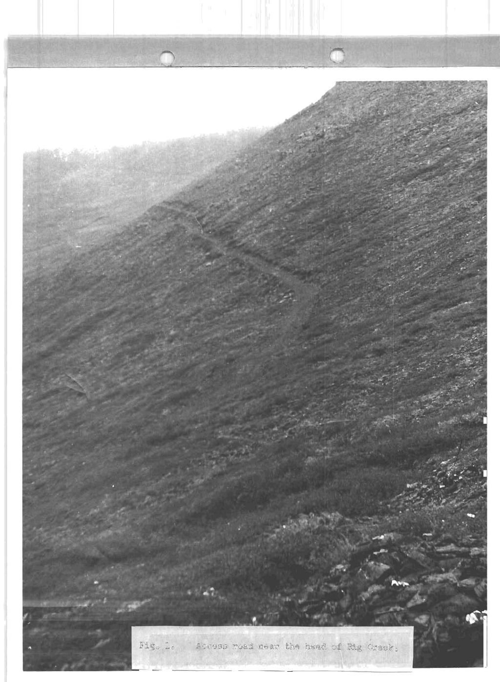
1 REPORT ON EXPLORATION IN THE CHANDALAR DISTRICT, 1962 During August 18 to 21, 1962, James A, Fdilliams, Director of the Division of Mines Minerals, and Robert H. Saunders, State Mining Engineer, made a trip to the Chandalar District, where the Little Squaw Mining Company is explorhng for gold lodes, The trip was ma.d.e via. Wien Alaska Airlines by way of Bettles, and, at the time of the flight in, good weather made a landing on the Big Creek airstrip possible. On the return, however, it was deemed advisable to wa3.k from the camp on Big Creek to Chandalar Lake rather than risk the weather prohibiting landing at Big Creek, Exploration in the Chandalar by the Little Squaw Mining Company began in 1960, when the company reopened underground workings on the Piikado lode and drove more than 600 feet of new underground workings. More than 11,000 tons of ore was blocked out by this work, In 1961, buildings and equipment on Big Creek were purchased from the Chandalar Mining Company, and, in 1962, with Om assistance, the Little Squaw Mining Company began trenching on some of the veins in the district. Eskib Anderson is in overall charge of the exploration work, and Frank Birch is in direct charge; four other men are emplogred, Two tractors that formerly were used for placer mining on Big Creek are being used for trenching and road building, The camp buildings purchased from the Chandalar Piiining Company are used as living quarters, If the trenching program is successful, the 0BlE contract probably rzri.11 be continued to provide for additional underground work, By mid-august of 1962, the trenching had traced the Midado lode from the portal in the Tobin Creek drainage over the divide to
2 the Big Creek side of the ridge, a distance of more than 3000 feet. A trench on Big Creek 100 yards downstream from Toussaintts mill had u.ncovered a 30-ft-wide the "IndicateH vein, quartz -vein believed to be what has been called The quartz in this vein is iron-stained, but no other minerals are visible in it. Also, by mid-august, an access road had been built to within one-half mile of the Little Squaw vein, This vein is exposed in an adit 120 f t long on the left limit of upper Little Squaw Creek, The adit is four feet wide, and the vein is at least as hide as the adit, hand-dug pits above the adit, The vein also is exposed in some old hee gold is sisible in pieces of quartz on the dumps, After the remaining one-half mile of access road is completed, more of this vein w i l l be exposed by trenching, In conjunction %nth the trenching in 1962, the Little Squa-rrr Mirain2 Company built 7 miles of access road from the ce-flp on Big Creek to the areas in ~fi~hich trenching was planned. The road is mostly on ridges and hill.sides that are covered by talus tha.t is permanently frozen except for a few feet of suriuner thaw, The road has been built by using bulldozers with angle blades, exca'trsting only enough talus for an 8-ft-.wide roadway, Blasting has been n.ecessary iil only a fera places wnere the tal~s cover was lacking or thin. Although no culverts have been used. in the roa,d, it is planned. that open-top culverts eventually >rill be installed, A \Tillys Jeep station wagon with four-wheel drive is used in traveling from the camp to t'ne different hr0rking places. Some of the writch-back turns on the steeper slopes are too sharp for %he Jeep to negotiate without backing, however, they were made in that manner
3 because frozen ground was encountered, and, after the permafrost recedes from the exca.va,ted areas, it is expected that these turns can be widened easily. The road has been essential for the explora,tion program, and, although it would. not be passae5l.e for a conventional automobile, it is serving the purpose for which it was built, The airstrip on Big Creek can be a.pproached for landing by aircraft froin only one direction - downstream. Beyond the upstream end of the airstrip, the ground rises so abruptly tha.t, after an airplane begins its approach, it must land; there is no space in which it can circle for a second try, Frequently, visibility on upper Big Creek is poor, even when visibility is good between Chandalar Lake and Bettles, Cross winds in the valley are common, and, even when visibility is good, wind may make landings impossible* The trail from Big Creek to Chandalar Lake (about 8 miles) is passable by tractor during part of the year but at other times can be traveled only on foot; it traverses several swampy areas, Because of these conditions, mail and freight for the exploration project usually are left at Chandalar Lake, and the lighter items are back-packed to the Big Creek camp, J Items too heavy for back-packing accunlulate at the lake until weather conditions are good enough to permit landing on the Big' Creek airstrip, From time -I;o time, explora.tion work is delayed or hampered became a needed item is at the lake and ca,nnot be flotm. or ba,ck-packed to the camp. A roa,d from the existing road network to the airstrip at Chandalar Lake is needed badly. The route that appears most feasible for such a road leaves the existing road. nea-r the Mikado workings and goes around the
4 head of Tobin Creek, down the ridge on the right limit of the creek, axd across the creek to the airstrip. All of this route is over the same type of terrzin that the present road is on, except for about one mile near the airstrip and across the Tobin Creek valley. This one mile of road. is swampy and would require some fill, The chief obstacle to building the road down to Chanda1a.r Lake is that no equip- ment suitzble for transporting the necessary fill is available in the area. College, Alaska Karch, 1963 Robert H. Saunders State Mining Engineer

5
PROSPECTING REPORT. re. Minera.1 C laims
 PROSPECTING REPORT re. Minera.1 C laims P R 1 Record #3052 (6) P R 2 Record #3053 (6) p R 3 Record #3054 (6) at Ilong.129, Latt. 58 20' in the Two Mile Creek area of Turnagain River drainage system in
City of Six Project. Gold Mining Property in Downieville, CA. 60 Acres of Claims. Estimated Resource of over 8,800 ounces of Gold
 City of Six Project Gold Mining Property in Downieville, CA 60 Acres of Claims Estimated Resource of over 8,800 ounces of Gold Adjoining the famous Ruby Mine Property Located on a Rich Tertiary Channel
Ingle Creek Placer Mine
 Location and Accessibility The Ingle Creek claims lie within the Fortymile mining district of east central Alaska. There are 3 40-acre state claims located 4 miles west of Chicken. Ingle Creek is a 2 mile
GEOLOGY Warren Mining District Idaho County, Idaho March SlI4HARY
 r?..:. F-_.,'.': t.,.. I ~ j. ii lucky BEN motp GEOLOGY Warren Mining District Idaho County, Idaho March 1984 SlI4HARY.., The Lucky Ben Croup of claims cover a gold prospect located in the Wdrren Mining
LUCKY BEN MINE PROJECT SEPTEMBER 2018 UPDATE
 LUCKY BEN MINE PROJECT SEPTEMBER 2018 UPDATE During the first week of July 2018 work was completed by our Geologist, Richard Morris, and support personnel to stake the Lucky Ben vein structure at surface
NordWand Enterprize Mineral Exploration of Remote Regions P.O. Box Fairbanks, Alaska (vox & fax)
") Mineral Exploration of Remote Regions -2811 907-474-0943 (vox & fax) jokeener@acsalaska.net 1 October 2006 Richard Walters, President Little Squaw Gold Mining Company 3412 S. Lincoln Drive Spokane, WA
Mineral Exploration of Remote Regions -2811 907-474-0943 (vox & fax) jokeener@acsalaska.net 1 October 2006 Richard Walters, President Little Squaw Gold Mining Company 3412 S. Lincoln Drive Spokane, WA
Advanced Geologic Exploration, Inc.
 Advanced Geologic Exploration, Inc. Scientists of the Earth PO Box 1956, Chester, CA 96020 Voice: (530) 258-4228 Fax (530) 258-4339 www.advancedgeologic.com January 23, 2009 Job No. G-081201 Terri Barber,
Materials. Use materials meeting the following.
 208.01 Section 208. SOIL EROSION AND SEDIMENTATION CONTROL 208.01 Description. Install and maintain erosion and sedimentation controls to minimize soil erosion and to control sedimentation from affecting
12 tons of high-grade ore was mined from the No. 1 vein with an average grade of 13 g/t gold, 3,250 g/t silver and 23.3% lead.
 DUNWELL MINE GROUP The Dunwell Mine Group (Dunwell, Dunwell East, Bear River/MM and Silvershot properties), which includes the historic, past-producing Dunwell mine, is located 8 km northeast of Stewart
Rock Scaling Recommendations Logan Creek Drive Cut Slope
 Rock Scaling Recommendations Logan Creek Drive Cut Slope US 50, Milepost DO 8.47 to DO 8.61 Douglas County, Nevada January 2008 MATERIALS DIVISION STATE OF NEVADA DEPARTMENT OF TRANSPORTATION MATERIALS
1.0 INSPECTION ANNUAL INSPECTION, JUNE 29, 2011 CARMACKS COPPER PROJECT, CARMACKS, YUKON. Dear Mr. West-Sells,
 Doc. No. 162 Rev. 0 Mr. Paul West-Sells President & Chief Operating Officer Western Copper Corporation 2060-1111 West Georgia Street Vancouver, BC V6E 4M3 ANNUAL INSPECTION, JUNE 29, 2011 CARMACKS COPPER
SEISMIC REFRACTION SURVEY RIPPABILITY STUDY
 SEISMIC REFRACTION SURVEY RIPPABILITY STUDY US 95A SILVER SPRINGS to FERNLEY LYON COUNTY August 2008 E.A. 73455 MATERIALS DIVISION SEISMIC REFRACTION SURVEY RIPPABILITY STUDY LYON COUNTY US 95A SILVER
PENNSYLVANIA DEPARTMENT OF TRANSPORTATION ENGINEERING DISTRICT 3-0
 PENNSYLVANIA DEPARTMENT OF TRANSPORTATION ENGINEERING DISTRICT 3-0 LYCOMING COUNTY S.R.15, SECTION C41 FINAL HYDROLOGIC AND HYDRAULIC REPORT STEAM VALLEY RUN STREAM RELOCATION DATE: June, 2006 REVISED:
Early Exploration Plan Activity Information
 Early Exploration Plan Activity Information Activities That Require an Early Exploration Plan: Line cutting that is a width of 1.5 metres or less; Geophysical surveys on the ground requiring the use of
Tenmile Lakes Delta Building Study
 Tenmile Lakes Delta Building Study Since the late 1940 s, Tenmile Lakes has seen a sharp increase in sediment accumulation at the mouths of the tributaries that feed the lake. To monitor this sediment
HERON ENTERS OPTION TO PURCHASE A1 GOLD MINE, EASTERN VICTORIA
 ASX Release 13 AUGUST 2009 HERON ENTERS OPTION TO PURCHASE A1 GOLD MINE, EASTERN VICTORIA Heron Resources Limited (ASX:HRR, Heron) is pleased to announce it has purchased an Option (Option) to acquire
Appendix K: Field Photographs
 Campbell, M. D.; Lee, Roger W.; M. David Campbell (2017), "Gold and Other Metals in the Cao Ram Area, Doi Bu District, Hoa Binh Region, Southwest of Hanoi, Vietnam," J Geol Geosci, Vol.1, pp.1-38. Appendix
APPENDIX A TREATMENT ACTIVITIES BY ALTERNATIVE
 APPENDIX A TREATMENT ACTIVITIES BY ALTERNATIVE Table B-1: Summary of Activities by Alternative Activity Regeneration Harvest acres Intermediate Harvest acres Total Harvest Acres No Action Alt. 2 Proposed
COAU PROPERTY LEMHI COUNTY, IDAHO
 COAU PROPERTY LEMHI COUNTY, IDAHO Utah Mineral Resources 447 N 300 W, Suite 3 Kaysville, UT 84037 (801) 544-3421 ojgatten@nae-xploration.com Prepared by: North American Mine Services, LLC. March 21, 2017
TERRITORY OF ALASKA BOX 1391 JUNEAU. ALASKA. PRC:PE3TY EUF!IXATIc)N WORT. signed travelled to and made a brief exanination of the Four-in-One
N WORT. signed travelled to and made a brief exanination of the Four-in-One") TERRITORY OF ALASKA DEPARTMENT OF MINES BOX 1391 JUNEAU. ALASKA PRC:PE3TY EUF!IXATIc)N WORT FOUR-IN-OIL% COPPEB PROSPECT, ANCHORAGE QUADM~IGLE - K X 8~~ On September 11 to 13, 1954, Pnil 2. Holdsworth
TERRITORY OF ALASKA DEPARTMENT OF MINES BOX 1391 JUNEAU. ALASKA PRC:PE3TY EUF!IXATIc)N WORT FOUR-IN-OIL% COPPEB PROSPECT, ANCHORAGE QUADM~IGLE - K X 8~~ On September 11 to 13, 1954, Pnil 2. Holdsworth
RE~ORT ON. J.F.V. MILLAR, P. Eng. GEOCHEMICAL SURVEY TIMBASKET AND MOGUL MINERAL CLAIMS. Kinbasket Lake, B. C. 51 degrees 118 degrees N.E.
 RE~ORT ON GEOCHEMICAL SURVEY TIMBASKET AND MOGUL MINERAL CLAIMS Kinbasket Lake, B. C. 51 degrees 118 degrees N.E. J.F.V. MILLAR, P. Eng. Lease held by J.F.V. MILLAR Work done Sept. 22 - Oct. 3, 1967. REPORT
Early Exploration Permit Activity Information
 Early Exploration Permit Activity Information Activities That Require an Early Exploration Permit: Line cutting that is a width greater than 1.5 metres Mechanized stripping of a total surface area of greater
An Evaluation of Pavement Drainage Interstate 64, Rowan-Carter Counties
 Transportation Kentucky Transportation Center Research Report University of Kentucky Year 1984 An Evaluation of Pavement Drainage Interstate 64, Rowan-Carter Counties David L. Allen Herbert F. Southgate
entire 1.5 meter drift width
 GOLD HILL SUMMARY In 1864 gold fever struck in the south Kootenays east of Cranbrook, British Columbia as placer gold was discovered in the Wild Horse River. What followed was everything one can imagine
Update on Columbus Gold's Eastside Gold Discovery in Nevada
 Columbus Gold Corporation 1090 Hamilton Street Vancouver, B.C. V6B 2R9 Phone: (604) 634-0970 Fax: (604) 634-0971 Toll Free: 1 888 818-1364 info@columbusgroup.com www.columbusgroup.com NEWS RELEASE Update
BUREAU OF MINES IN-THE TIBBS CREEK AREA, GOODPASTER RIVER, BIG DELTA QUADRANGLE, CENTRAL ALASKA. wl : by Bruce I. Thomas
 > RECONNAISSANCE OF THE GOLD-BEARING QUARTZ VEINS IN-THE TIBBS CREEK AREA, GOODPASTER RIVER, BIG DELTA QUADRANGLE, CENTRAL ALASKA wl : by Bruce I. Thomas ::'0% S 0 open fil X ;:0report w, UNITED STATES
Early Mountain Railroads in the lower Pennsylvania Anthracite Coalfields during the 19th century
 Early Mountain Railroads in the lower Pennsylvania Anthracite Coalfields during the 19th century Richard Healey Dept. of Geography University of Portsmouth Anthracite as a Commodity Hard, shiny coal with
AiG ON THE EASTRIM mm. Record number KENNJZDY LAKE AREA - ALBERNI MINING DIVISION Map 92Fl3 W
 ON THE EASTRIM mm CLAIM Record number 3799 19 KENNJZDY LAKE AREA - ALBERNI MINING DIVISION Map 92Fl3 W 125" 23' West Lbngitude - 49" 09' North Latitude Walter GUPPY August ZO;i;! t I : AiG272002 TABLE
average rate of change
 average rate of change Module 2 : Investigation 5 MAT 170 Precalculus August 31, 2016 question 1 A car is driving away from a crosswalk. The distance d (in feet) of the car from the crosswalk t seconds
Gold c 8 Rl!TI I8 8 I0 n0 '8 Off VANCOUVER, B.C. btandard I Property
 ,- PROSPECTING REPORT For the 1 Gold c 8 Rl!TI I8 8 I0 n0 '8 Off ig@ VANCOUVER, B.C. btandard I Property I SALMON GOVERNMENT AGENT ARM I Tenure Number 554772 Revelstoke Mining Division, B.C. BCGS GRID
American Creek Resources is a precious metals exploration company with an impressive portfolio of high-potential gold
 American Creek Resources is a precious metals exploration company with an impressive portfolio of high-potential gold and silver projects in British Columbia. These include properties in B.C.'s prolific
Find graphically, using scaled diagram, following vectors (both magnitude and direction):
:") 1 HOMEWORK 1 on VECTORS: use ruler and protractor, please!!! 1. v 1 = 3m/s, E and v = 4m/s, 3 Find graphically, using scaled diagram, following vectors (both magnitude and direction): a. v = v 1 + v b.
1 HOMEWORK 1 on VECTORS: use ruler and protractor, please!!! 1. v 1 = 3m/s, E and v = 4m/s, 3 Find graphically, using scaled diagram, following vectors (both magnitude and direction): a. v = v 1 + v b.
3.12 Geology and Topography Affected Environment
 3 Affected Environment and Environmental Consequences 3.12 Geology and Topography 3.12.1 Affected Environment 3.12.1.1 Earthquakes Sterling Highway MP 45 60 Project Draft SEIS The Kenai Peninsula is predisposed
ROSE OF DENMARK MINE RE-DEVELOPMENT COMMENCES
 Friday, 1 October 2010 ROSE OF DENMARK MINE RE-DEVELOPMENT COMMENCES Redevelopment of Key Regional target Rose of Denmark Mine Rose of Denmark is a High Grade shallow depth opportunity Multiple samples
Snow Measurement Guidelines for National Weather Service Snow Spotters
 Snow Measurement Guidelines for National Weather Service Snow Spotters National Weather Service Forecast Office Northern Indiana October 2004 Table of Contents Introduction 3 Definitions.. 3 Relaying Real
DIRECTORY OF COAL MINES IN ILLINOIS
 DIRECTORY OF COAL MINES IN ILLINOIS Champaign County This directory accompanies the Illinois Coal Mines map or maps for this County. August 2018 Prairie Research Institute Illinois State Geological Survey
Erosion Surface Water. moving, transporting, and depositing sediment.
 + Erosion Surface Water moving, transporting, and depositing sediment. + Surface Water 2 Water from rainfall can hit Earth s surface and do a number of things: Slowly soak into the ground: Infiltration
Weathering, Mass Wasting and Karst
 Weathering, Mass Wasting and Karst Capable of wearing down anything that the internal processes can build. Gravity, water, wind and ice Denudation - the overall effect of disintegration, wearing away and
Reconnaissance. Of the. Denis mineral claims. Situated at Kilometer 844 of the Alaska Highway. Liard Mining Division. Northeastern British Columbia
 Reconnaissance Of the Denis mineral claims Situated at Kilometer 844 of the Alaska Highway Liard Mining Division Northeastern British Columbia N.T.S. 94M.075 Latitude 59 42 25 Longitude 127 13 12 Field
C13^COMMONWEALTH OF AUSTRALIA
 tal C13^COMMONWEALTH OF AUSTRALIA DEPARTMENT OF NATIONAL DEVELOPMENT BUREAU OF MINERAL RESOURCES, GEOLOGY AND GEOPHYSICS 44 1 NE/41 RECORD No. 1963/22 l^' it Ril R y#11, 1 zz^g M^ P3 C3 rn 00 GEOPHYSICAL
CAS PROJECT LEMHI COUNTY, IDAHO
 CAS PROJECT LEMHI COUNTY, IDAHO 447 N 300 W, Suite 3 Kaysville, UT 84037 (801) 544-3421 ojgatten@nae-xploration.com Prepared by: North American Mine Services, LLC. May 25, 2017 CAS Project Summary The
1. In the block diagram shown here, which is the oldest rock unit?
 Pre/Post GCI Name (print) 1. In the block diagram shown here, which is the oldest rock unit? 2. Referring to the same diagram as the previous question, which of the labeled rock units is the youngest?
Geologic Setting and History of Mining in the Animas River Watershed, southern Colorado
 Geologic Setting and History of Mining in the Animas River Watershed, southern Colorado Virginia T. McLemore New Mexico Bureau of Geology and Mineral Resources, New Mexico Tech, Socorro, NM On August 5,
Lake Sedimentation Survey of Siloam Springs State Park Lake, Adams County, Illinois
 Contract Report 567 Lake Sedimentation Survey of Siloam Springs State Park Lake, Adams County, Illinois by Richard L. Allgire Office of Sediment & Wetland Studies Prepared for the Illinois Department of
DIRECTORY OF COAL MINES IN ILLINOIS
 DIRECTORY OF COAL MINES IN ILLINOIS Hamilton County This directory accompanies the Illinois Coal Mines map or maps for this County. August 2017 Prairie Research Institute Illinois State Geological Survey
MARKET UPDATE ON URANIUM AND GOLD PROJECTS
 ASX Announcement 1 March 2011 MARKET UPDATE ON URANIUM AND GOLD PROJECTS HIGHLIGHTS 5,000 metre drilling programme to commence at Rio Puerco uranium project within the next two weeks. Drilling to commence
1.4 Geology Regional Geology
 Lode Mining Activity The largest lode production from mines in the immediate True North area came from the Soo property, also known as the Spaulding, patented in June 1913. From 1912 to 1914, this mine
Report on Exploration of Waterhen Claims Port Alberni Area of British Columbia. n 1 - Tenure # Tenure #399108
 Report on Exploration of Waterhen Claims Port Alberni Area of British Columbia n 1 - Tenure #399107 2 - Tenure #399108 Location: Victoria Mining Division Owner: Barry Hanslit Operator: Barry Hanslit A
CONTINUING GOLDEN LEGACY
 CONTINUING GOLDEN LEGACY Drill Hole 14-707 grading 14,394 g/t Gold & 6830 g/t Silver (1) (1)Over 0.75m at Premier INVESTOR PRESENTATION AUGUST 13 2018 CAUTIONARY STATEMENT This presentation contains certain
Assessment Report #
 Table Of Contents Event Sheet #5576884 Exploration Program for 2015 Summery Introduction Location and Access Climate Local Resources and infrastructure Physiography Property Bedrock Geology History of
SITE WORKS COMMENCE AT A1 GOLD MINE, EASTERN VICTORIA
 ASX Release 4 th November 2009 SITE WORKS COMMENCE AT A1 GOLD MINE, EASTERN VICTORIA Heron Resources Limited (ASX:HRR, Heron) is pleased to announce commencement of site works at the A1 Gold Mine in eastern
Underground Hydrology of the Commodore Mine Complex and Implications for Source Control. Jeff T. Graves
 Underground Hydrology of the Commodore Mine Complex and Implications for Source Control Jeff T. Graves Investigation Approach Purpose Determine location/s, quality and quantity of groundwater inflows into
I 4.w.g //old. Lat. 5Oo35T Long T. for. By: James R. Glass, P. Eng. June 6, DUSTY MAC MINES LTD. (N.P.L.)
") 440 6 REPORT ON MAGNETOMETER SURVEY POD GROU'OF CLAIMS HIGHLAND VALLEY KAMLOOPS MINING DIVISION Lat. 5Oo35T Long. 120 55T 9.2 1 //old for DUSTY MAC MINES LTD. (N.P.L.) By: James R. Glass, P. Eng. June
440 6 REPORT ON MAGNETOMETER SURVEY POD GROU'OF CLAIMS HIGHLAND VALLEY KAMLOOPS MINING DIVISION Lat. 5Oo35T Long. 120 55T 9.2 1 //old for DUSTY MAC MINES LTD. (N.P.L.) By: James R. Glass, P. Eng. June
REDWOOD VALLEY SUBAREA
 Independent Science Review Panel Conceptual Model of Watershed Hydrology, Surface Water and Groundwater Interactions and Stream Ecology for the Russian River Watershed Appendices A-1 APPENDIX A A-2 REDWOOD
Town of Barnstable. Department of Public Work. Snow and Ice Control Operations Plan
 Town of Barnstable Department of Public Work Snow and Ice Control Operations Plan I. Mission: The mission of the Department of Public Works is to remove accumulations of snow and ice from town, county
FOLLOW-UP ON CHANNELIZATION IN SPRING CREEK SUB-WATERSHED
 FOLLOW-UP ON CHANNELIZATION IN SPRING CREEK SUB-WATERSHED Justin R. Beebe, Department of Earth Sciences, University of South Alabama, Mobile, AL 36688. jrb308@jaguar1.usouthal.edu. Spring Creek is a tributary
Prospecting Report 'S Office i DB Property, B.C. -J Negro Creek Nelson Mining District NTS 82F.050. Operator: Kootenay Gold Inc.
 . '.' I"' i9 12 Prospecting Report 'S Office i DB Property, B.C. -J Negro Creek Nelson Mining District NTS 82F.050 Operator: Kootenay Gold Inc. Owner: Darlene Lavoie Work Performed Summer of 2007 Report
GEOLOGICAL BRANCH ASSESSMENT RERnRT. Assessment Report on Physical Work. CAYOOSH CONDOR Group of Placer Claims Lillooet Mining Division
 Assessment Report on Physical Work CAYOOSH CONDOR Group of Placer Claims Lillooet Mining Division PC 105 CAYOOSH CONDOR I1 PC 106 CAYOOSH CONDOR John P. La Rue June loth, 1991 Lillooet, B.C. GEOLOGICAL
While all thunderstorms are dangerous, the National Weather Service (NWS) defines a severe thunderstorm as one that:
 defines a severe thunderstorm as one that:") While all thunderstorms are dangerous, the National Weather Service (NWS) defines a severe thunderstorm as one that: Produces hail at least three-quarters of an inch in diameter. Has winds of 58 miles
While all thunderstorms are dangerous, the National Weather Service (NWS) defines a severe thunderstorm as one that: Produces hail at least three-quarters of an inch in diameter. Has winds of 58 miles
TRAFFIC ALERT FOR WEEK OF February 4 8, 2008
 TRAFFIC ALERT FOR WEEK OF February 4 8, 2008 Highway work zones in the Staunton District The following is a list of highway work that might affect traffic in the Staunton transportation district during
June 9, R. D. Cook, P.Eng. Soils Engineer Special Services Western Region PUBLIC WORKS CANADA WESTERN REGION REPORT ON
 PUBLIC WORKS CANADA WESTERN REGION REPORT ON GEOTECHNICAL INVESTIGATION PROPOSED MARTIN RIVER BRIDGE MILE 306.7 MACKENZIE HIGHWAY Submitted by : R. D. Cook, P.Eng. Soils Engineer Special Services Western
Amador Canyon Silver Mining Property Lander County, NV
 Amador Canyon Silver Mining Property Lander County, NV Over $1 million worth of exploration and evaluation work performed Favorable drill results including a return of 286 g/ton silver over 12.2 meters
58 l'gr'n 'E. Date: January 23, 1979 ASSESSMENT REPORT PLACER SAMPLING & JADE BOULDER EVALUATION PLACER LEASE Liard Mining Divison 1041/7E
 ASSESSMENT REPORT PLACER SAMPLING & JADE BOULDER EVALUATION PLACER LEASE 1711 Liard Mining Divison 1041/7E 58 l'gr'n 18 38'E Owner & operator: Cry Lake Jade Mines Ltd. Author: A.M. Homenuke, P.Eng. Date:
GRISWOLD CREEK, B.C. 6 " GEOCHJ3lICAL REPORT
 GRISWOLD CREEK, B.C. 6 " GEOCHJ3lICAL REPORT AUTROR: W. Meyer, BSc. ENDORSED El!: John De Leen, BASc.* NASc., E.M., P. Eng. No. 3675 Vancouver, B.C. January 22nd, 1965. -I- During the period of July 27th
Elephant Mountain, Alaska Intrusive Related Gold Project July Option to Earn 100%
 Elephant Mountain, Alaska Intrusive Related Gold Project July 2018 Option to Earn 100% CORPORATE Corporate DISCLOSURE Disclosure The information contained herein, while obtained from sources which we believe
For personal use only
 UPDATE ON COCK-EYED BOB UNDERGROUND MINING INCREASING CONFIDENCE IN THE POTENTIAL FOR THREE LONG-LIFE UNDERGROUND MINES Integra Mining Limited (ASX:IGR, Integra) is pleased to report that the trial mining
A test boring program was utilized in this study in order to verify. existing information, and to obtain otherwise unavailable data that was
 TEST BORING RESULTS A test boring program was utilized in this study in order to verify existing information, and to obtain otherwise unavailable data that was considered vital for the formulation of an
DIRECTORY OF COAL MINES IN ILLINOIS
 DIRECTORY OF COAL MINES IN ILLINOIS Marion County This directory accompanies the Illinois Coal Mines map or maps for this County. August 2018 Prairie Research Institute Illinois State Geological Survey
3.12 Geology and Topography Affected Environment
 3 Affected Environment and Environmental Consequences 3.12 Geology and Topography 3.12.1 Affected Environment 3.12.1.1 Earthquakes Sterling Highway MP 45 60 Project Final EIS The Kenai Peninsula is predisposed
Helm Bay Gold Belt, Southeast Alaska
 Helm Bay Gold Belt, Southeast Alaska Avalon Development Corporation Summary Report 2015 17 Historic Prospects - 10 km Strike Length 10,000 oz pre-wwii Production No Modern Exploration and No Drilling Conducted
Montgomery Bedrock Geology 21d-Gowganda Formation: conglomerate, sandstone, siltstone, argillite
 Work Report 2014 Trenching Montgomery Township G-3303 Claim #4259384,4245818 Sault Ste. Marie Mining Division Michael & Yvon Gagne Montgomery Copper Property 1 P a g e 2 P a g e Montgomery Bedrock Geology
Erosion Information Paper Eagle City and Eagle Village, Alaska Current as of January 21, 2008
 U.S. Army Corps of Engineers ALASKA BASELINE EROSION ASSESSMENT Erosion Information Paper Eagle City and Eagle Village, Alaska Current as of January 21, 2008 Community Information The City of Eagle, population
Fish Passage at Road Crossings
 Fish Passage at Road Crossings 1 Crossing Design Workshop Outline 1:00 to 2:00 Intro, Design Overview, Channel Width 2:00 to 2:15 Break 2:15 to 3:15 No-Slope, Stream Simulation Design 3:15 to 3:30 Break
Technical Report. On the. Owl Claim(s) Date: Jan. 17, Claim # Written By Lucas Handley. Claim Owner
 Date: Jan. 17, Claim # Written By Lucas Handley. Claim Owner") Technical Report On the Owl Claim(s) Date: Jan. 17, 2011 Claim # 837846 838049 838242 859407 Written By Lucas Handley Claim Owner Intro The 4 claims covered in this report cover what was mostly historically
Technical Report On the Owl Claim(s) Date: Jan. 17, 2011 Claim # 837846 838049 838242 859407 Written By Lucas Handley Claim Owner Intro The 4 claims covered in this report cover what was mostly historically
GREEN SHEET. California Department of Forestry and Fire Protection (CAL FIRE)
") GREEN SHEET California Department of Forestry and Fire Protection (CAL FIRE) Informational Summary Report of Serious CAL FIRE Injuries, Illnesses, Accidents and Near Serious Accidents Dozer Rollover Fatality
GREEN SHEET California Department of Forestry and Fire Protection (CAL FIRE) Informational Summary Report of Serious CAL FIRE Injuries, Illnesses, Accidents and Near Serious Accidents Dozer Rollover Fatality
EROSIONAL FEATURES. reflect
 reflect Have you ever looked at the land around you and wondered what processes shaped what you see? Perhaps you see mountains, valleys, rivers, or canyons. Do you know how long these geologic features
PROSPECTING REPORT PLACER CLAIM - FOX 4 SIMILKAMEEN MINING DIVISION MAP - 092H GPS COORDINATE REFERENCE CENTER OF CLAIM ' 6"N, 120.
 2011 PROSPECTING REPORT PLACER CLAIM - FOX 4 TENURE #793322 EVENT #5160421 SIMILKAMEEN MINING DIVISION MAP - 092H GPS COORDINATE REFERENCE CENTER OF CLAIM 49. 24' 6"N, 120. 36* 30" W REPORT PREPARED BY
DIRECTORY OF COAL MINES IN ILLINOIS
 DIRECTORY OF COAL MINES IN ILLINOIS Pope County This directory accompanies the Illinois Coal Mines map or maps for this County. August 2018 Prairie Research Institute Illinois State Geological Survey 615
Strategy. Focus on the western United States, mostly Nevada and California. Concentrate on projects with high grade and size potential
 Exploring for Gold and Silver in the US Jan. 2005 Strategy Focus on the western United States, mostly Nevada and California Concentrate on projects with high grade and size potential Become a gold producer
O ITHIS )WE OF WORK IN I EXTENT OF WORK I I PROJECT COSTS I ON WHICH CLAIMS (IN METRIC UNITS) APPORTIONED (id. support) GEOLOGICAL (scale, area)
WE OF WORK IN I EXTENT OF WORK I I PROJECT COSTS I ON WHICH CLAIMS (IN METRIC UNITS) APPORTIONED (id. support) GEOLOGICAL (scale, area)") Geological Survey Branch TITLE OF REPORT [type of SUNOY(S)] TOTAL COST 1 MINERAL INVENTORY M OWNER@) MAILING ADDRESS -.,-- a 5 -a OPERATOR(S) [who paid ffo the wnk) 2) MAILING ADDRESS 76e2 HWY 97/gm LP
Geological Survey Branch TITLE OF REPORT [type of SUNOY(S)] TOTAL COST 1 MINERAL INVENTORY M OWNER@) MAILING ADDRESS -.,-- a 5 -a OPERATOR(S) [who paid ffo the wnk) 2) MAILING ADDRESS 76e2 HWY 97/gm LP
Prospecting Report on the Dynasty Jade Claims
 Prospecting Report on the Dynasty Jade Claims Claims 519762, 520237, 520336 Mining Division - Liard NTS or BCGS location 104J080 Latitude and longitude of geographic centre of work 58.78 N 130.08 W Owner
Town of Oconomowoc Snow & Ice Control Policy
 Town of Oconomowoc Snow & Ice Control Policy Introduction The purpose of this policy is to provide a detailed overview of the Town s snow & ice control operations including its goals and objectives. All
July 2, Re: Governor Mine: Review of geological data and field reconnaissance, TerraMins Project No
 July 2, 2014 T. A. Bishara Century 21 Bright Horizons 3110 E. Garvey Ave. S. West Covina, CA 91791 Re: Governor Mine: Review of geological data and field reconnaissance, Dear Mr. Bishara, This letter is
ENGINEERING EVALUATION OF THE STANLEY MINE ADVENTURE PARK AREA CLEAR CREEK COUNTY, COLORADO. Prepared for:
 braun Braun Consulting Engineers ENGINEERING EVALUATION OF THE STANLEY MINE ADVENTURE PARK AREA CLEAR CREEK COUNTY, COLORADO Prepared for: STANLEY MINES ADENTURE PARK 3375 W. POWERS CIRCLE LITTLETON, COLORADO
6-1 Slope. Objectives 1. find the slope of a line 2. use rate of change to solve problems
 6-1 Slope Objectives 1. find the slope of a line 2. use rate of change to solve problems What is the meaning of this sign? 1. Icy Road Ahead 2. Steep Road Ahead 3. Curvy Road Ahead 4. Trucks Entering Highway
ARCHAEOLOGICAL FEATURES RELATED TO COPPER MINING ( ) AT MINERS HEAD, GREAT BARRIER ISLAND SUMMARY
 AT MINERS HEAD, GREAT BARRIER ISLAND SUMMARY") ARCHAEOLOGICAL FEATURES RELATED TO COPPER MINING (1842-1867) AT MINERS HEAD, GREAT BARRIER ISLAND by P.R. Moore State Highway 25, RD 1, Waihi SUMMARY Copper mining at Miners Head, Great Barrier Island,
ARCHAEOLOGICAL FEATURES RELATED TO COPPER MINING (1842-1867) AT MINERS HEAD, GREAT BARRIER ISLAND by P.R. Moore State Highway 25, RD 1, Waihi SUMMARY Copper mining at Miners Head, Great Barrier Island,
Incas Manganese Prospect, Bristol Mountains, San Bernardino County, California
 Incas Manganese Prospect, Bristol Mountains, San Bernardino County, California Gregg Wilkerson 2017 Acknowledgement and Disclaimer The information in this paper is taken largely from published sources.
The Gold Hill s Big Chief Showing. Cross Section Line A-A' (Pighin 2014)
") GOLD HILL SUMMARY In 1864 gold fever struck in the south Kootenays east of Cranbrook, British Columbia as placer gold was discovered in the Wild Horse River. What followed was everything one can imagine
GOLD HILL SUMMARY In 1864 gold fever struck in the south Kootenays east of Cranbrook, British Columbia as placer gold was discovered in the Wild Horse River. What followed was everything one can imagine
Good Spirit School Division Parents/Guardians
 Photo by: Macdonald School Bus Driver, Louise Szumutku, 2018 Good Spirit School Division Parents/Guardians With winter approaching we wanted to take this opportunity to remind all our families about procedures
SL GEOLOGY AND MINING. Coal bearing strata in the project area are referable primarily to the Allegheny Group of
 SL-145-1 GEOLOGY AND MINING Coal bearing strata in the project area are referable primarily to the Allegheny Group of Pennsylvania age. These rocks occur as dissected remnants overlying the ridge-forming
Erosional Features. What processes shaped this landscape?
 Have you ever looked at the land around you and wondered what processes shaped what you see? Perhaps you see mountains, valleys, rivers, or canyons. Do you know how long these geologic features have been
Composition of the crust. Ore deposits. Ore distribution. Resources: Mineral resources. Reading: Today: Ch 12 (to p306)
") Composition of the crust Resources: Mineral resources Reading: Today: Ch 12 (to p306) QUESTION Ore deposits A rock containing a useful metal in a useable concentration Ore distribution by definition ore
Composition of the crust Resources: Mineral resources Reading: Today: Ch 12 (to p306) QUESTION Ore deposits A rock containing a useful metal in a useable concentration Ore distribution by definition ore
Mineral resources. Composition of the crust. Resources: Reading: Today: Ch 12 (to p306) QUESTION Environmental Geology Mineral resources
 QUESTION Environmental Geology Mineral resources") Resources: Mineral resources Reading: Today: Ch 12 (to p306) QUESTION Composition of the crust 1 Ore deposits A rock containing a useful metal in a useable concentration Concentration factor = concentration
Resources: Mineral resources Reading: Today: Ch 12 (to p306) QUESTION Composition of the crust 1 Ore deposits A rock containing a useful metal in a useable concentration Concentration factor = concentration
PROJECT AREA CON LAKE. MAP No. G-22 - CASTLEWOOD LAKE AREA DISTRICT OF THUNDER BAY OP90-372
 42E13NE888I 63.5922 CASTLEWOOD LAKE 010 PROJECT AREA CON LAKE MAP No. G-22 - CASTLEWOOD LAKE AREA DISTRICT OF THUNDER BAY OP90-372 TECHNICAL REPORT FINAL SUBMISSION M. NELSON CLAIM BLOCK OP90-372 #1 TRENCH
EPS 50 Lab 5 The Hayward Fault at UC Berkeley
 EPS 50 Lab 5 The Hayward Fault at UC Berkeley Introduction: On this field trip we will see some of the most dramatic expressions of the Hayward Fault in the Berkeley area. Most of the subtle geomorphic
GEOCHEMICAL REPORT THE 82M/12 FH GROUP BIRCH ISLAND, B.C. S1 119O NOW. ROYAL CANADIAN VENTUR 3S LTD. By: Vollo, P. Eng. N.B. Pay 28th, 1969.
 c GEOCHEMICAL REPORT ON THE 82M/12 FH GROUP AT BIRCH ISLAND, BC S1 119O NOW BY ROYAL CANADIAN VENTUR 3S LTD NB By: Vollo, P Eng Pay 28th, 1969 Approximately 700 samples were collected over 14 miles of
CITY OF MINOT SNOW REMOVAL PLAN JANUARY 2015
 CITY OF MINOT SNOW REMOVAL PLAN JANUARY 2015 1.0 GENERAL This plan has been written to provide information regarding snow removal procedures and policies. The plan provides guidance, while maintaining
LONG LAKE ZINC MINE. Selected References "Zinc and Lead Deposits of Canada'% Geol. Surv. Can., Econ. Geol. Series, No k 8, 1930, pp, H6-151.
 April,1952 31CI8NW8eie 63.3149 OLDEN 010 ^ LONG LAKE ZINC MINE Selected References Alcock, P.J., "Zinc and Lead Deposits of Canada'% Geol. Surv. Can., Econ. Geol. Series, No k 8, 1930, pp, H6-151. Harding,
4J)SESSMEN'I' REPORT BRANCH. cc" FILE No: ASSESSMENT REPORT VICTORIA MINING DIVISION. Latitude 123O SF' Longitude 48O S5'
SESSMEN'I' REPORT BRANCH. cc FILE No: ASSESSMENT REPORT VICTORIA MINING DIVISION. Latitude 123O SF' Longitude 48O S5'") ASSESSMENT REPORT - ON THE ORM 1 MINERAL CLAIM VICTORIA MINING DIVISION NTS 92B cc" Latitude 123O SF' Longitude 48O S5' 3-2. w N C FILE No: @&@LOGI.CAL BRANCH 4J)SESSMEN'I' REPORT Date : June 1, 1990 TABLE
ASSESSMENT REPORT - ON THE ORM 1 MINERAL CLAIM VICTORIA MINING DIVISION NTS 92B cc" Latitude 123O SF' Longitude 48O S5' 3-2. w N C FILE No: @&@LOGI.CAL BRANCH 4J)SESSMEN'I' REPORT Date : June 1, 1990 TABLE
James A Schuyler 220 Palo Alto Avenue San Francisco CA (415) September, 2004
 September, 2004") James A Schuyler 220 Palo Alto Avenue San Francisco CA 94114 (415) 242-2424 26 September, 2004 I went to Yosemite backcountry with Clark Quinn last weekend (September, 2004) for a couple of days. We did
James A Schuyler 220 Palo Alto Avenue San Francisco CA 94114 (415) 242-2424 26 September, 2004 I went to Yosemite backcountry with Clark Quinn last weekend (September, 2004) for a couple of days. We did