A test boring program was utilized in this study in order to verify. existing information, and to obtain otherwise unavailable data that was
|
|
|
- Oswald Lucas
- 5 years ago
- Views:
Transcription
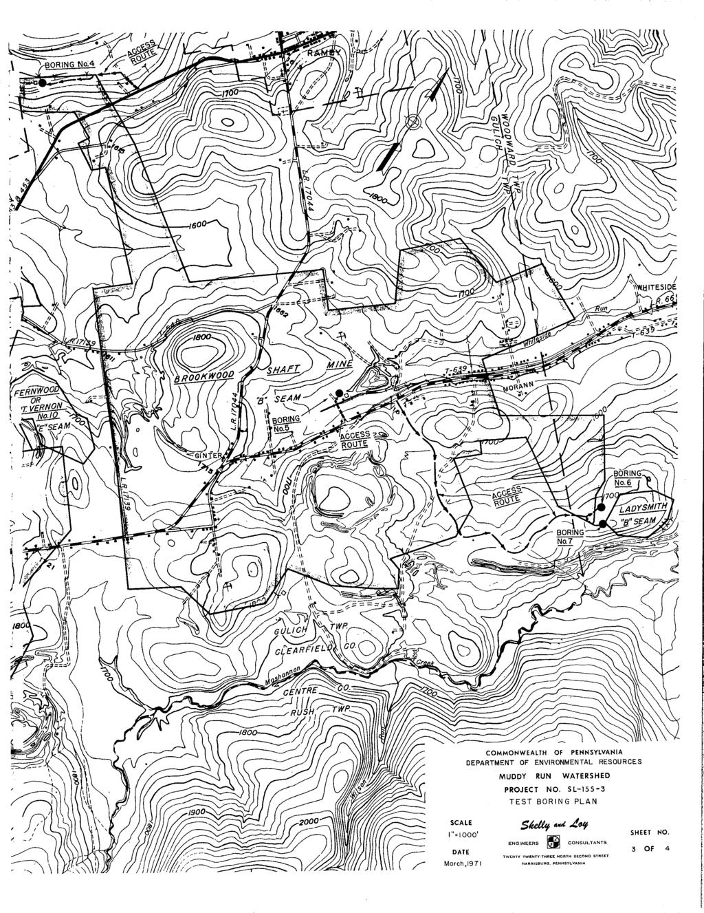
1 TEST BORING RESULTS A test boring program was utilized in this study in order to verify existing information, and to obtain otherwise unavailable data that was considered vital for the formulation of an abatement plan. A total of 23 bore holes were drilled as located on the Test Boring Plan Sheet. All of the holes were cored and pressure tests were made at selectively chosen points where permeability data was required to determine the feasibility of various sealing methods. Pennsylvania Drilling Company performed the drilling under the field direction of a geologist provided by SKELLY and LOY. At the completion of drilling and logging, the cores were given to the Pennsylvania Topographic and Geologic Survey for a more detailed lithologic study, in order to supplement their previous work in this area. A reliable abatement method could not be formulated for some of the larger pollution sources using only presently available data. Most of the borings were subsequently utilized to gather information concerning large, discharging deep mines that were designated as Quick Start projects. Sealing of these mines will place large hydrostatic heads on adjacent rock units. The core borings and pressure tests were used to determine: 1) the ability of the adjacent rock strata to hold the anticipated
2 head (type and condition of rocks, permeability); 2) condition of the mine working in which the seal was to be placed; 3) the best location for the seal; 4) the best type of sealing procedure; 5) parameters that permit more accurate design specifications; and 6) reliability of previously available information. of the boring program. Item 6 proved to be more important than it seemed at the inception For instance: 1) It was believed that the entryways for the White Oak Mine were all drifts. However, test borings showed that the "A" coal cropped much lower on the hillside, and that some of the "drifts" were slopes. When this mine was first sealed, flows occurred through the outcrop barrier, and the basements of some of the homes along Route 453 south of Madera were flooded. A diversion drain will be placed in the area back of the houses to prevent this from recurring when this mine is resealed. The test borings provided the coal elevation
3 data necessary for the determination of the, location of. this trench. The borings also provided information that allowed more accurate placement of the mine maps with relation to the surface features. The test borings indicated that the rock units are very permeable. This will require the seals to be placed as far back from the portals as possible, and points out the necessity for construction of a grout curtain.. 2) It, was discovered that the two largest pollution sources (the Brookwood Shaft Mine and the Eureka Mine Complex) were flooded to a greater degree than was originally assumed. Since no direct measure of mine water elevation was available initially, the mine water elevation was assumed to be the same as the elevation of the discharge point. It was found during the borings that the mine water elevation was much higher. This is due to the existence of a driving head (of water) that caused artesian discharges long distances from the surface of the mine pool. It was discovered that both Brookwood and Eureka were flooded approximately 60 feet higher than the elevation of the discharge point.
4 3) Adjustments were made to coal contours in critical areas. It was also discovered that the Eureka Mine Complex was originally mapped on a datum that was 17 feet below the U.S.G.S. datum. Prior to the test boring program, the Lower Kittanning coal contours were drawn by extrapolation across the Great Bend Mine between Mountaindale and Blandburg, because of inadequate data within this interval. The test borings provided data for more accurate adjustment of the coal contours. This, in turn, provided more accurate determination of the heads to be produced by the sealing operations. 4) The water level in test boring no. 19 provided answers to the many questions concerning the water situation in the Bucket Mine and Cambria Mills Smokeless Mine No. 2 near Mountaindale. Some local residents thought these mines were directly connected to the Scott Brothers Mine No. 2, which is part of a large mine complex on the "B" seam located to the north. If this condition did exist, then the additional head would render the sealing of this large complex next to impossible. Prior to the test borings the origin of
5 the water discharging at pollution source 118 was unknown. The discharge could have been from either: (1) the overflow from a fully flooded Bucket Mine Complex; or (2) gravity drainage from the Great Bend Mine. The appropriate abatement scheme could not be determined until these questions were answered. The water level in hole no. 19 proved that the Bucket Mine and Cambria Mills Smokeless Mine No. 2 were not directly connected to the Scott Brothers Mine No. 2. It indicated that seepage is probably occurring at a slow rate through the coal barrier between these mines. It also indicated the Bucket Mine and Cambria Mills Smokeless Mine No. 2 share a common pool, but that they are not flooded to a high enough elevation to cause a discharge at pollution source 118. In summation, the boring program provided extremely useful and necessary information required to formulate a feasible abatement plan within this watershed.
6 COMMONWEALTH OF PENNSYLVANIA DEPARTMENT OF ENVIRONMENTAL RESOURCES MUDDY RUN WATERSHED PROJECT NO. SL TEST BORINGS CLEARFIELD AND CAMBRIA COUNTIES

7

8
9

10
11
12
13
14
15
16
17
18
19
20
21
22
23
II. SYNOPSIS. ( ) Indicates sampling point numbers
 Indicates sampling point numbers") II. SYNOPSIS II. SYNOPSIS The basis for this report is the data derived from field investi - gations, subsurface exploration, a water sampling and testing program and maps of the deep and surface mines
II. SYNOPSIS II. SYNOPSIS The basis for this report is the data derived from field investi - gations, subsurface exploration, a water sampling and testing program and maps of the deep and surface mines
CLEARFIELD CREEK, MOSHANNON CREEK BIBLIOGRAPHY
 REFERENCES CLEARFIELD CREEK, MOSHANNON CREEK BIBLIOGRAPHY Ashley, George H.; Geologic and Mineral Resources of the Curwensville Quadrangle, A75, Topographic and Geologic Survey, 2nd printing, 1969. Centre
INTRODUCTION. 1. Have the major acid mine discharges from the Shaw Mines Complex changed during
 INTRODUCTION I-1 INTRODUCTION The Questions 1. Have the major acid mine discharges from the Shaw Mines Complex changed during the period of observation 1967-1983, i.e., have acid, iron and sulfate concentrations
USING ESRI s ARCSCENE TO VISUALIZE THE GEOSPATIAL RELATIONSHIP BETWEEN A COAL REFUSE DISPOSAL AREA, AMD SEEPS, AND UNDERGROUND MINING OPERATIONS 1
 USING ESRI s ARCSCENE TO VISUALIZE THE GEOSPATIAL RELATIONSHIP BETWEEN A COAL REFUSE DISPOSAL AREA, AMD SEEPS, AND UNDERGROUND MINING OPERATIONS 1 Thomas A. Galya 1 and Thomas Mastrorocco 2 Abstract. Downstream
Pressure Grouting of Fractured Bedrock to Control Acid Mine Drainage
 WATER RESOURCES AT RISK May 14-18, 1995 Denver American Institute of Hydrology Pressure Grouting of Fractured Bedrock to Control Acid Mine Drainage S. A. Effner, G. D. Vandersluis, and V. Straskraba Hydro-Geo
HOOVER DAM: Grout Curtain Failure and Lessons Learned in Site Characterization
 HOOVER DAM: Grout Curtain Failure and Lessons Learned in Site Characterization J. David Rogers Dams Symposium Association of Engineering Geologists Annual Meeting Las Vegas, Nevada September 22, 2005 The
SLOPE STABILITY EVALUATION AND ACCEPTANCE STANDARDS
 INFORMATION BULLETIN / PUBLIC - BUILDING CODE REFERENCE NO.: LABC 7006.3, 7014.1 Effective: 01-01-2017 DOCUMENT NO.: P/BC 2017-049 Revised: 12-21-2016 Previously Issued As: P/BC 2014-049 SLOPE STABILITY
SL GEOLOGY AND MINING. Coal bearing strata in the project area are referable primarily to the Allegheny Group of
 SL-145-1 GEOLOGY AND MINING Coal bearing strata in the project area are referable primarily to the Allegheny Group of Pennsylvania age. These rocks occur as dissected remnants overlying the ridge-forming
Identifying and Sealing Water Loss Zones in the Anthracite Coal Region
 Identifying and Sealing Water Loss Zones in the Anthracite Coal Region Terry Ackman, Environmental Science and Technology Division United States Department of Energy, Pittsburgh, PA Robert Dilmore, Department
The headwaters of Blacklegs Creek originate near Parkwood in Indiana County
 III BASIN DESCRIPTION A. Location, Area and Drainage The headwaters of Blacklegs Creek originate near Parkwood in Indiana County approximately eight (8) miles west of Indiana, Pennsylvania. The main stream
CHAPTER III STUDY AREA DESCRIPTION
 CHAPTER III STUDY AREA DESCRIPTION The study area originally assigned to this project was the West Branch watershed above Cherry Tree, Pennsylvania which involves a drainage area of 43 square miles. The
SLOPE STABILITY EVALUATION AND ACCEPTANCE STANDARDS
 INFORMATION BULLETIN / PUBLIC - BUILDING CODE REFERENCE NO.: LAMC 98.0508 Effective: 1-26-84 DOCUMENT NO. P/BC 2002-049 Revised: 11-1-02 Previously Issued As: RGA #1-84 SLOPE STABILITY EVALUATION AND ACCEPTANCE
Mitigation of Gypsum Mine Voids Under SR-2 in Ottawa County, Ohio
 Subsurface Investigation and Conceptual Alternatives Mitigation of Gypsum Mine Voids Under SR-2 in Ottawa County, Ohio Presented By: Ohio Department of Transportation CH2M HILL CTL Engineering Technos,
COAL STATUS REPORT. MINING UNDER OR NEAR THIS SITE: Yes No Future Possibility Unknown Coal Seam Non-Existent
 REVISED 1/25/2012 PAGE 1 OF 2 DEPARTMENT OF ENVIRONMENTAL PROTECTION DISTRICT MINING OPERATIONS 25 Technology Drive California Technology Park Coal Center, PA 15423 (724) 769-1100 COAL STATUS REPORT NAME:
Bedrock Dewatering for Construction of Marmet and Soo Lock Projects
 Bedrock Dewatering for Construction of Marmet and Soo Lock Projects Michael Nield Engineering Geologist Dam Safety Production Center, Huntington, WV August 2012 US Army Corps of Engineers BEDROCK DEWATERING
An Introduction to Field Explorations for Foundations
 An Introduction to Field Explorations for Foundations J. Paul Guyer, P.E., R.A. Paul Guyer is a registered mechanical engineer, civil engineer, fire protection engineer and architect with over 35 years
P.R. SPRING AND HILL CREEK TAR SAND AREAS A RESOURCE ASSESSMENT (IN PROGRESS)
") P.R. SPRING AND HILL CREEK TAR SAND AREAS A RESOURCE ASSESSMENT (IN PROGRESS) presented by WALLY GWYNN - Utah Geological Survey at the Western U.S. Oil Sands Technology Transfer Meeting February 22, 2008
P.R. SPRING AND HILL CREEK TAR SAND AREAS A RESOURCE ASSESSMENT (IN PROGRESS) presented by WALLY GWYNN - Utah Geological Survey at the Western U.S. Oil Sands Technology Transfer Meeting February 22, 2008
Electronic Submission Format Guide Large Noncoal (Industrial Minerals) Mine Permit Application (5600-PM-BMP0315)
 Mine Permit Application (5600-PM-BMP0315)") Electronic Submission Format Guide Large Noncoal (Industrial Minerals) Mine Permit Application (5600-PM-BMP0315) Module 1: Application Section A through Section I, the Application Checklist, and all narrative
Electronic Submission Format Guide Large Noncoal (Industrial Minerals) Mine Permit Application (5600-PM-BMP0315) Module 1: Application Section A through Section I, the Application Checklist, and all narrative
Prof. B V S Viswanadham, Department of Civil Engineering, IIT Bombay
 13 Permeability and Seepage -2 Conditions favourable for the formation quick sand Quick sand is not a type of sand but a flow condition occurring within a cohesion-less soil when its effective stress is
10. GEOTECHNICAL EXPLORATION PROGRAM
 Geotechnical site investigations should be conducted in multiple phases to obtain data for use during the planning and design of the tunnel system. Geotechnical investigations typically are performed in
Groundwater Rebound in the South Yorkshire Coalfield: A review of initial modelling
 Groundwater Rebound in the South Yorkshire Coalfield: A review of initial modelling 1 S. P. Burke, 1 H. A.B. Potter and 2 A. Jarvis 1 Environment Agency: Science Group, Olton Court, Olton,Solihull UK 2
Electronic Submission Format Guide Anthracite Preparation Plant Permit Application
 Electronic Submission Format Guide Anthracite Preparation Plant Permit Application Module 1: Application Section A through Section J, the Application Checklist, and all narrative responses Act 67 / 68
Module/Unit: Landforms Grade Level: Fifth
 Module/Unit: Landforms Grade Level: Fifth PA Academic Standards for Science and Technology and Environment and Ecology: 3.1.7.B Describe the use of models as an application or scientific or technological
Electronic Submission Format Guide Bituminous Coal Surface Mine Permit Application (5600-PM-BMP0311)
") Electronic Submission Format Guide Bituminous Coal Surface Mine Permit Application (5600-PM-BMP0311) Module 1: Application Section A through Section J, the Application Checklist, and all narrative responses.
Electronic Submission Format Guide Bituminous Coal Surface Mine Permit Application (5600-PM-BMP0311) Module 1: Application Section A through Section J, the Application Checklist, and all narrative responses.
Core Description, Stratigraphic Correlation, and Mapping of Pennsylvanian Strata in the Appalachians
 Core Description, Stratigraphic Correlation, and Mapping of Pennsylvanian Strata in the Appalachians The remaining laboratory sessions for the semester will be collected into a series of exercises designed
GEOL 3700 STRUCTURE AND TECTONICS LABORATORY EXERCISE 3
 GEOL 3700 STRUCTURE AND TECTONICS LABORATORY EXERCISE 3 Goals: 1. Improve your map-reading and map-making skills. 2. Learn to generate and interpret structure contour maps. 3. Learn to generate and interpret
Chapter 7 Permeability and Seepage
 Permeability and Seepage - N. Sivakugan (2005) 1 7.1 INTRODUCTION Chapter 7 Permeability and Seepage Permeability, as the name implies (ability to permeate), is a measure of how easily a fluid can flow
A BOOKLET ON. T Rangasamy, A R Leach and A P Cook. Facilitating safety and health research in the South African mining industry
 A BOOKLET ON THE HYDRAULIC DESIGN OF COAL BARRIER PILLARS T Rangasamy, A R Leach and A P Cook Facilitating safety and health research in the South African mining industry A BOOKLET ON THE HYDRAULIC DESIGN
Predictions for Aquifer Dewatering over Underground Mines in the Pittsburgh, Sewickley, and Upper Freeport Coals of Northern West Virginia
 Predictions for Aquifer Dewatering over Underground Mines in the Pittsburgh, Sewickley, and Upper Freeport Coals of Northern West Virginia ABSTRACT by Henry W. Rauch 1 William N. O'Steen 2 Gerald Ahnell
SITE INVESTIGATION 1
 SITE INVESTIGATION 1 Definition The process of determining the layers of natural soil deposits that will underlie a proposed structure and their physical properties is generally referred to as site investigation.
1.72, Groundwater Hydrology Prof. Charles Harvey Lecture Packet #5: Groundwater Flow Patterns. Local Flow System. Intermediate Flow System
 1.72, Groundwater Hydrology Prof. Charles Harvey Lecture Packet #5: Groundwater Flow Patterns c Local Flow System 10,000 feet Intermediate Flow System Regional Flow System 20,000 feet Hydrologic section
CHAPTER GEOLOGICALLY HAZARDOUS AREAS Applicability Regulations.
 CHAPTER 19.07 GEOLOGICALLY HAZARDOUS AREAS 19.07.010 Applicability. Geologically hazardous areas may pose a threat to the health and safety of citizens when incompatible development is sited in areas of
GEOLOGY A. PHYSIOGRAPHY
 GEOLOGY A. PHYSIOGRAPHY The watershed under study lies completely in the Allegheny High Plateaus section of the Appalachian Plateaus Province approximately 30 miles west of the Allegheny Front. (See Plate
Dealing with Zone A Flood Zones. Topics of Discussion. What is a Zone A Floodplain?
 Dealing with Zone A Flood Zones Topics of Discussion Overview of Zone A Floodplains Permitting Development in Zone A Floodplains Estimating Flood Elevations in Zone A Flood Insurance Implications Letters
Mapping Earth. How are Earth s surface features measured and modeled?
 Name Mapping Earth How are Earth s surface features measured and modeled? Before You Read Before you read the chapter, think about what you know about maps Record your thoughts in the first column Pair
DIRECTORY OF COAL MINES IN ILLINOIS
 DIRECTORY OF COAL MINES IN ILLINOIS Champaign County This directory accompanies the Illinois Coal Mines map or maps for this County. August 2018 Prairie Research Institute Illinois State Geological Survey
Subsurface Mapping 1 TYPES OF SUBSURFACE MAPS:- 1.1 Structural Maps and Sections: -
 Subsurface Mapping The purpose of subsurface mapping in the geology of petroleum Is to find traps that contain oil and gas pools and the information obtained from wells forms the heart of the data upon
Rogun Hydropower Project
 Rogun Hydropower Project Dam site Geological investigations in the Downstream Right Bank Ascencio Lara Coyne et Bellier Almaty, 11-12 February 2013 Objectives of the presentation As the stability conditions
Early Exploration Plan Activity Information
 Early Exploration Plan Activity Information Activities That Require an Early Exploration Plan: Line cutting that is a width of 1.5 metres or less; Geophysical surveys on the ground requiring the use of
Oklahoma Geological Survey Oklahoma Coal Database ANALYTICAL HEADER TABLE DOCUMENTATION
 Oklahoma Geological Survey Oklahoma Coal Database ANALYTICAL HEADER TABLE DOCUMENTATION Point ID Data point identification number: the system is tied to location and is intended to provide a unique identifier
Montour No. 1 (Bob Ciminel 2012)
") Montour No. 1 (Bob Ciminel 2012) Montour No.1 Mine was located at Southview, PA, west of Venice off of PA Route 50 and between McDonald Viaduct and Gilmore Junction on the Montour Railroad. Montour No.
Montour No. 1 (Bob Ciminel 2012) Montour No.1 Mine was located at Southview, PA, west of Venice off of PA Route 50 and between McDonald Viaduct and Gilmore Junction on the Montour Railroad. Montour No.
SCOPE OF INVESTIGATION Simple visual examination of soil at the surface or from shallow test pits. Detailed study of soil and groundwater to a
 Lecture-5 Soil Exploration Dr. Attaullah Shah 1 Today s Lecture Purpose of Soil Exploration Different methods 1. Test trenches and Pits 2. Auger and Wash Boring 3. Rotary Drilling 4. Geophysical Methods
DIRECTORY OF COAL MINES IN ILLINOIS
 DIRECTORY OF COAL MINES IN ILLINOIS Hamilton County This directory accompanies the Illinois Coal Mines map or maps for this County. August 2017 Prairie Research Institute Illinois State Geological Survey
NRCS - THUNDER ROAD #3, TRIBUTARY TO QUILEUTE RIVER CULVERT REMOVAL AND REPLACEMENT PLAN CLALLAM COUNTY, WA., WRIA: 20, SITE:
 WDFW CONTROL POINT #1 Re-Bar, Elevation Northing 10004.441 Easting 8002.5905 WDFW CONTROL POINT #2 Re-Bar, Elevation 101.36 Northing 10031.6683 Easting 846.0623 Spike in Tree Elevation = 102.95 Elevation
WEIR INTERNATIONAL, INC. Mining, Geology and Energy Consultants
 WEIR INTERNATIONAL, INC. Mining, Geology and Energy Consultants Introduction to Coal Mining History of Coal in the United States Coal was one of man s earliest sources of heat and light Coal was first
YELLOWSTONE RIVER FLOOD STUDY REPORT TEXT
 YELLOWSTONE RIVER FLOOD STUDY REPORT TEXT TECHNICAL REPORT Prepared for: City of Livingston 411 East Callender Livingston, MT 59047 Prepared by: Clear Creek Hydrology, Inc. 1627 West Main Street, #294
Lecture 15: Subsidence
 Lecture 15: Subsidence Key Questions 1. How does removal of groundwater cause subsidence on a regional scale? 2. Under what conditions does a building sink into sediment? 3. Why do clays consolidate more
Application of Fluvial Geomorphologic Techniques At Abandoned Mine Sites 1. David A. Greenfield 2 Dennis M. Palladino 3
 Application of Fluvial Geomorphologic Techniques At Abandoned Mine Sites 1 David A. Greenfield 2 Dennis M. Palladino 3 ABSTRACT Watersheds that have been severely impacted by mining can no longer transport
Landslide Granice in Zagreb (Croatia)
") Landslides and Engineered Slopes Chen et al. (eds) 28 Taylor & Francis Group, London, ISBN 978--415-41196-7 Landslide Granice in Zagreb (Croatia) Z. Mihalinec Civil Engineering Institute of Croatia, Zagreb,
Landslides and Engineered Slopes Chen et al. (eds) 28 Taylor & Francis Group, London, ISBN 978--415-41196-7 Landslide Granice in Zagreb (Croatia) Z. Mihalinec Civil Engineering Institute of Croatia, Zagreb,
II. EXISTING CONDITIONS
 II. EXISTING CONDITIONS WATERSHED CHARACTERISTICS For the study purposes, each watershed was divided into sub-areas, representing different topographic, mining, or runoff conditions. Limits of these watersheds
Underground Hydrology of the Commodore Mine Complex and Implications for Source Control. Jeff T. Graves
 Underground Hydrology of the Commodore Mine Complex and Implications for Source Control Jeff T. Graves Investigation Approach Purpose Determine location/s, quality and quantity of groundwater inflows into
Appendix E Guidance for Shallow Flooding Analyses and Mapping
 Appendix E Guidance for Shallow Flooding Analyses and Mapping E.1 Introduction Different types of shallow flooding commonly occur throughout the United States. Types of flows that result in shallow flooding
TSEGI WASH 50% DESIGN REPORT
 TSEGI WASH 50% DESIGN REPORT 2/28/2014 Daniel Larson, Leticia Delgado, Jessica Carnes I Table of Contents Acknowledgements... IV 1.0 Project Description... 1 1.1 Purpose... 1 Figure 1. Erosion of a Headcut...
Ground-Water Exploration in the Worthington Area of Nobles County: Summary of Seismic Data and Recent Test Drilling Results
 Ground-Water Exploration in the Worthington Area of Nobles County: Summary of Seismic Data and Recent Test Drilling Results Jim Berg and Todd Petersen Geophysicists, DNR Waters January 2000 Table of Contents
THE NEED FOR AN ADDITIONAL SPILLWAY AT THE SANFORD DAM BOILING SPRING LAKES, NC. Presentation for The Brunswick County Commissioners April 20, 2015
 THE NEED FOR AN ADDITIONAL SPILLWAY AT THE SANFORD DAM BOILING SPRING LAKES, NC Presentation for The Brunswick County Commissioners April 20, 2015 The Sanford Dam Earth Dam constructed in 1961 Drainage
Subsurface Geology of the Kennebec River
 Maine Geologic Facts and Localities July, 1998 Subsurface Geology of the Kennebec River 43 54 40.75 N, 69 48 29.01 W Text by Daniel B. Locke, Department of Agriculture, Conservation & Forestry 1 Map by
Groundwater Hydrology
 EXERCISE 12 Groundwater Hydrology INTRODUCTION Groundwater is an important component of the hydrologic cycle. It feeds lakes, rivers, wetlands, and reservoirs; it supplies water for domestic, municipal,
HISTORY OF CONSTRUCTION FOR EXISTING CCR SURFACE IMPOUNDMENT PLANT GASTON ASH POND 40 CFR (c)(1)(i) (xii)
(1)(i) (xii)") HISTORY OF CONSTRUCTION FOR EXISTING CCR SURFACE IMPOUNDMENT PLANT GASTON ASH POND 40 CFR 257.73(c)(1)(i) (xii) (i) Site Name and Ownership Information: Site Name: E.C. Gaston Steam Plant Site Location:
HISTORY OF CONSTRUCTION FOR EXISTING CCR SURFACE IMPOUNDMENT PLANT GASTON ASH POND 40 CFR 257.73(c)(1)(i) (xii) (i) Site Name and Ownership Information: Site Name: E.C. Gaston Steam Plant Site Location:
PENNSYLVANIA DEPARTMENT OF TRANSPORTATION ENGINEERING DISTRICT 3-0
 PENNSYLVANIA DEPARTMENT OF TRANSPORTATION ENGINEERING DISTRICT 3-0 LYCOMING COUNTY S.R.15, SECTION C41 FINAL HYDROLOGIC AND HYDRAULIC REPORT STEAM VALLEY RUN STREAM RELOCATION DATE: June, 2006 REVISED:
Geologic Mapping Regional Tournament Trial Event
 Geologic Mapping Regional Tournament Trial Event A TEAM OF UP TO: 2 Team Name AVAILABLE TIME: 50 min Required Materials: Each team MUST have a protractor, ruler, non-programmable calculator, colored pencils,
DRILLING REPORT (DGO-GO-14)
") Commonwealth of Virginia Department of Mines, Minerals, and Energy Division of Gas and Oil P.O. Box 1416; Abingdon, VA 24212 Telephone: (276) 676-5423 Tracking Number: Company: File Number: Operations
Commonwealth of Virginia Department of Mines, Minerals, and Energy Division of Gas and Oil P.O. Box 1416; Abingdon, VA 24212 Telephone: (276) 676-5423 Tracking Number: Company: File Number: Operations
A. Refer to Appendix F in back of lab manual for list of commonly used geologic map symbols
 Structural Geology Lab 2: Outcrop Patterns and Structure Contours I. Geologic Map Symbols A. Refer to Appendix F in back of lab manual for list of commonly used geologic map symbols 1. Emphasis: a. strike
FRACTURE TRACES AND PRODUCTIVITY OF MUNICIPAL WELLS IN THE MADISON LIMESTONE, RAPID CITY, SOUTH DAKOTA
 Proceedings of the South Dakota Academy of Science, Vol. 87 (2008) 261 FRACTURE TRACES AND PRODUCTIVITY OF MUNICIPAL WELLS IN THE MADISON LIMESTONE, RAPID CITY, SOUTH DAKOTA Perry H. Rahn Department of
NRCS - THUNDER ROAD #2, TRIBUTARY TO QUILEUTE RIVER CULVERT REMOVAL AND REPLACEMENT PLAN CLALLAM COUNTY, WA., WRIA: 20, SITE:
 WDFW CONTROL POINT #1 Re-Bar, Elevation 100.00 Northing 10004.441 Easting 8002.5905 WDFW CONTROL POINT #2 Re-Bar, Elevation 101.36 Northing 10031.6683 Easting 846.0623 WDFW TBM #1 Spike in Tree Elevation
*** ***! " " ) * % )!( & ' % # $. 0 1 %./ +, - 7 : %8% 9 ) 7 / ( * 7 : %8% 9 < ;14. " > /' ;-,=. / ١
 * % )!( & ' % # $. 0 1 %./ +, - 7 : %8% 9 ) 7 / ( * 7 : %8% 9 < ;14. > /' ;-,=. / ١") ١ ******!" #$ % & '!( ) % * ") +,-./ % 01. 3 ( 4 56 7/4 ) 8%9 % : 7 ;14 < 8%9 % : *7./ = ;-, >/'." Soil Permeability & Seepage ٢ Soil Permeability- Definition ٣ What is Permeability? Permeability is the
١ ******!" #$ % & '!( ) % * ") +,-./ % 01. 3 ( 4 56 7/4 ) 8%9 % : 7 ;14 < 8%9 % : *7./ = ;-, >/'." Soil Permeability & Seepage ٢ Soil Permeability- Definition ٣ What is Permeability? Permeability is the
Provincial Standards for Early Exploration
 Introduction Provincial Standards for Early Exploration Effective April 10, 2018 These Provincial Standards have been developed as part of the implementation of the graduated regulatory regime for early
a z41. COMMONWEALTH OF AUSTRALIA DEPARTMENT OF NATIONAL DEVELOPMENT BUREAU OF MINERAL RESOURCES, GEOLOGY AND GEOPHYSICS RECORD 1961 No.
 a z41. COMMONWEALTH OF AUSTRALIA ff..4 *.re /Veis DEPARTMENT OF NATIONAL DEVELOPMENT BUREAU OF MINERAL RESOURCES, GEOLOGY AND GEOPHYSICS RECORD 1961 No. 66 RED TANK BORE GRAVITY SURVEY, PLENTY RIVER, N.T.
Background. Valley fills Sites in the Area. Construction over Mine Spoil Fills
 Construction over Mine Spoil Fills Wayne A. Karem, PhD, PE, PG, D.GE 2014 KSPE Annual Conference Background Strip mining; mountaintop and contour mining Creates huge quantities of mine spoil The mine spoil
Instructor : Dr. Jehad Hamad. Chapter (7)
") Instructor : Dr. Jehad Hamad Chapter (7) 2017-2016 Soil Properties Physical Properties Mechanical Properties Gradation and Structure Compressibility Soil-Water Relationships Shear Strength Bearing Capacity
Instructor : Dr. Jehad Hamad Chapter (7) 2017-2016 Soil Properties Physical Properties Mechanical Properties Gradation and Structure Compressibility Soil-Water Relationships Shear Strength Bearing Capacity
ENGINEERING EVALUATION OF THE STANLEY MINE ADVENTURE PARK AREA CLEAR CREEK COUNTY, COLORADO. Prepared for:
 braun Braun Consulting Engineers ENGINEERING EVALUATION OF THE STANLEY MINE ADVENTURE PARK AREA CLEAR CREEK COUNTY, COLORADO Prepared for: STANLEY MINES ADENTURE PARK 3375 W. POWERS CIRCLE LITTLETON, COLORADO
Erosion Surface Water. moving, transporting, and depositing sediment.
 + Erosion Surface Water moving, transporting, and depositing sediment. + Surface Water 2 Water from rainfall can hit Earth s surface and do a number of things: Slowly soak into the ground: Infiltration
Local Flood Hazards. Click here for Real-time River Information
 Local Flood Hazards Floods of the White River and Killbuck Creek are caused by runoff from general, and/or intense rainfall. Other areas of flooding concern are from the Boland Ditch and Pittsford Ditch.
HOW. HOW vehicle mounted units portable units also available. HOW, WHEN & WHY to Geophysically Log in S.I.?
 HOW, WHEN & WHY to Geophysically Log in S.I.? by Kim Beesley HOW HOW vehicle mounted units portable units also available Access to borehole Depth of borehole sump / rat -hole? 1 HOW? - subject to borehole
15 Mineral Resources (Item 19)
") Powertech Uranium Corp. 15-1 15 Mineral Resources (Item 19) Section 15 is extracted in-part from Powertech s Technical Report titled Updated Technical Report on the Centennial Uranium Project, Weld County,
Powertech Uranium Corp. 15-1 15 Mineral Resources (Item 19) Section 15 is extracted in-part from Powertech s Technical Report titled Updated Technical Report on the Centennial Uranium Project, Weld County,
Module 10: Resources and Virginia Geology Topic 4 Content: Virginia Geology Notes
 Virginia is composed of a very diverse landscape that extends from the beaches and barrier islands all of the way to the highly elevated Appalachian Plateau. Geologists have discovered ancient shallow
Data Collection & Sample Storage
 Development, Implementation and Regulation of Exploration Programmes for Uranium Mineral Resources Data Collection & Sample Storage Regional Training Course: RAF 3007-2 Malawi, 24-28 May 2010 International
Influence of Surrounding Soil Conditions and Joint Sealing on Seepage Resistance of a Sheet Pile Wall, Three Dimensional Numerical Analyses
 IOP Conference Series: Earth and Environmental Science PAPER OPEN ACCESS Influence of Surrounding Soil Conditions and Joint Sealing on Seepage Resistance of a Sheet Pile Wall, Three Dimensional Numerical
DIRECTORY OF COAL MINES IN ILLINOIS
 DIRECTORY OF COAL MINES IN ILLINOIS Marion County This directory accompanies the Illinois Coal Mines map or maps for this County. August 2018 Prairie Research Institute Illinois State Geological Survey
DIRECTORY OF COAL MINES IN ILLINOIS 7.5-MINUTE QUADRANGLE SERIES BROADWELL QUADRANGLE LOGAN COUNTY. Margaret H. Bargh
 DIRECTORY OF COAL MINES IN ILLINOIS 7.5-MINUTE QUADRANGLE SERIES BROADWELL QUADRANGLE LOGAN COUNTY Margaret H. Bargh Department of Natural Resources ILLINOIS STATE GEOLOGICAL SURVEY 1994 REVISED 2009 DIRECTORY
DIRECTORY OF COAL MINES IN ILLINOIS 7.5-MINUTE QUADRANGLE SERIES COLUMBIA QUADRANGLE MONROE & ST. CLAIR COUNTIES
 DIRECTORY OF COAL MINES IN ILLINOIS 7.5-MINUTE QUADRANGLE SERIES COLUMBIA QUADRANGLE MONROE & ST. CLAIR COUNTIES Alan R. Myers 2013 Prairie Research Institute William W. Shilts, Executive Director ILLINOIS
APPENDIX H SOIL SURVEY
 Environmental Impact Statement Beryl Solar Farm APPENDIX H SOIL SURVEY Beryl Solar Farm 16 347 Final V1 H i Geotechnical Engineers & Engineering Geologists NATA Accredited Laboratories for Asphalt, Aggregate,
DIRECTORY OF COAL MINES IN ILLINOIS 7.5-MINUTE QUADRANGLE SERIES MT. PULASKI QUADRANGLE LOGAN COUNTY. G. K. Coats M. H. Bargh C. G.
 DIRECTORY OF COAL MINES IN ILLINOIS 7.5-MINUTE QUADRANGLE SERIES MT. PULASKI QUADRANGLE LOGAN COUNTY G. K. Coats M. H. Bargh C. G. Treworgy Department of Natural Resources ILLINOIS STATE GEOLOGICAL SURVEY
Measurement of effective stress shear strength of rock
 Measurement of effective stress shear strength of rock R. A. Failmezger, P.E., F. ASCE In-Situ Soil Testing, L.C., Lancaster, Virginia USA D. J. White, Ph. D., P.E. Iowa State University, Ames, Iowa USA
Early Exploration Permit Activity Information
 Early Exploration Permit Activity Information Activities That Require an Early Exploration Permit: Line cutting that is a width greater than 1.5 metres Mechanized stripping of a total surface area of greater
DIRECTORY OF COAL MINES IN ILLINOIS
 DIRECTORY OF COAL MINES IN ILLINOIS Pope County This directory accompanies the Illinois Coal Mines map or maps for this County. August 2018 Prairie Research Institute Illinois State Geological Survey 615
APPIN MINE 708D PRESSURE BUMPS
 APPIN MINE 708D PRESSURE BUMPS ROGER BYRNES SUPERINTENDENT GEOTECHNICAL SERVICES, ILLAWARRA COAL WOLLONGONG GAS AND COAL OUTBURST SEMINAR 22 NOVEMBER 2018 ABOUT SOUTH32 South32 - a mining and metals company
INFLOW DESIGN FLOOD CONTROL SYSTEM PLAN 40 C.F.R. PART PLANT YATES ASH POND 2 (AP-2) GEORGIA POWER COMPANY
 GEORGIA POWER COMPANY") INFLOW DESIGN FLOOD CONTROL SYSTEM PLAN 40 C.F.R. PART 257.82 PLANT YATES ASH POND 2 (AP-2) GEORGIA POWER COMPANY EPA s Disposal of Coal Combustion Residuals from Electric Utilities Final Rule (40 C.F.R.
INFLOW DESIGN FLOOD CONTROL SYSTEM PLAN 40 C.F.R. PART 257.82 PLANT YATES ASH POND 2 (AP-2) GEORGIA POWER COMPANY EPA s Disposal of Coal Combustion Residuals from Electric Utilities Final Rule (40 C.F.R.
Table 5-1 Sampling Program Summary for Milltown Ford Avenue Redevelopment Area, NJ.
 Table 5- Sampling Program Summary for Milltown Ford Avenue Redevelopment Area, NJ. Transformer Pads (9 pads: PAD 9) Evaluate if PCBs presently exist in soils adjacent to, and/or beneath the transformer
APPENDIX B WORKSHEETS & EXHIBITS
 APPENDIX B WORKSHEETS & EXHIBITS A worksheet provides the designer a representation of a measure that allows for input of specific design criteria. The plan designer will be required to assess field conditions
GEOL4714 Final Exam Fall 2005, C. H. Jones instructor
 GEOL4714 Final Exam Fall 2005 p. 1 GEOL4714 Final Exam Fall 2005, C. H. Jones instructor Name: Student ID #: Feel free to use the back of the sheets for answers needing more space. (1) (10 pts) For each
The first steps in the hydropower project cycle:
 The first steps in the hydropower project cycle: Initial investigations and feasibility studies 12 September 2013 Bruce Taylor Introduction Objectives of early stage studies Tools and methods Case study
Chapter 5 CALIBRATION AND VERIFICATION
 Chapter 5 CALIBRATION AND VERIFICATION This chapter contains the calibration procedure and data used for the LSC existing conditions model. The goal of the calibration effort was to develop a hydraulic
PENNSYLVANIA BITUMINOUS COAL PRODUCTION
 Background During 1997 over 73 million tons of bituminous coal was mined in Pennsylvania. More than 75% of the total production came from underground mines. The ratio of underground production versus total
July 2, Re: Governor Mine: Review of geological data and field reconnaissance, TerraMins Project No
 July 2, 2014 T. A. Bishara Century 21 Bright Horizons 3110 E. Garvey Ave. S. West Covina, CA 91791 Re: Governor Mine: Review of geological data and field reconnaissance, Dear Mr. Bishara, This letter is
CHAPTER 6, PRELIMINARY SITE INVESTIGATION CONTENTS
 CHAPTER 6, PRELIMINARY SITE INVESTIGATION CONTENTS - Page Purpose... 6-1 Assembly of data... 6-1 Use of aerial photographs... 6-2 Field study... 6-3 Mappix... 6-4 Repcrt of preliminary investigation...
Geologging Imagery, Applications and Geological Interpretation. Shea Altadonna 1, Jim Fulton 2, E.I.T.
 Geologging Imagery, Applications and Geological Interpretation Shea Altadonna 1, Jim Fulton 2, E.I.T. 1 Geologist, Advanced Construction Techniques Inc. 1000 N. West St. Ste 1200, Wilmington, DE 19801;
LOCATED IN INDIAN RIVER COUNTY PREPARED FOR S.J.R.W.M.D. AND F.W.C.D. DECEMBER, 2003 Updated 2007 Updated May 2014 PREPARED BY
 FELLSMERE WATER CONTROL DISTRICT EAST MASTER DRAINAGE PLAN AND STORMWATER HYDROLOGIC ANALYSIS OF THE GRAVITY DRAINAGE SYSTEM LOCATED BETWEEN THE EAST BOUNDARY, LATERAL U, THE MAIN CANAL, AND DITCH 24 LOCATED
High-resolution 2D surface seismic reflection survey to detect abandoned old coal mine works to improve mine safety
 High-resolution 2D surface seismic reflection survey to detect abandoned old coal mine works to improve mine safety LAWRENCE M. GOCHIOCO, GeoNano Technology Corporation, Katy, Texas, USA TIM MILLER, Sterling
Integration of Hydrogeologic and Geophysical Techniques for Identification of AMD Seepage and Remedial Design
 INTRODUCTION Integration of Hydrogeologic and Geophysical Techniques for Identification of AMD Seepage and Remedial Design Prepared by: Ronald H. Mullennex, C.P.G., C.G.W.P. Marshall Miller & Associates
DIRECTORY OF COAL MINES IN ILLINOIS 7.5-MINUTE QUADRANGLE SERIES SILVIS QUADRANGLE ROCK ISLAND COUNTY. Jennifer M. Obrad & C.
 DIRECTORY OF COAL MINES IN ILLINOIS 7.5-MINUTE QUADRANGLE SERIES SILVIS QUADRANGLE ROCK ISLAND COUNTY Jennifer M. Obrad & C. Chenoweth Institute of Natural Resources Sustainability ILLINOIS STATE GEOLOGICAL