Mitigation of Gypsum Mine Voids Under SR-2 in Ottawa County, Ohio
|
|
|
- Cameron Flynn
- 5 years ago
- Views:
Transcription
1 Subsurface Investigation and Conceptual Alternatives Mitigation of Gypsum Mine Voids Under SR-2 in Ottawa County, Ohio Presented By: Ohio Department of Transportation CH2M HILL CTL Engineering Technos, Inc. Workhorse Technologies

2

3
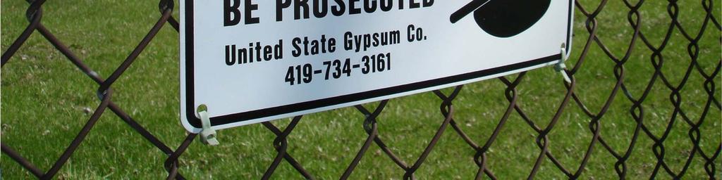
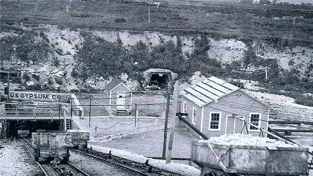
4 History Gypsum mined from 1902 to 1977 Section under SR-2 mined 1950 s 1960 s SR-2 constructed in 1965 Mines flooded in 1979 Active sinkholes since Dec. 2004


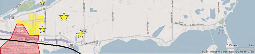
5 Location Lake Erie Sandusky Bay Mine Area


6
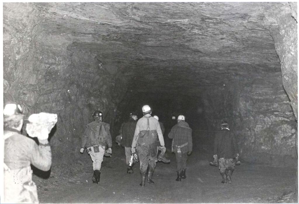
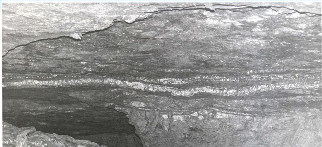
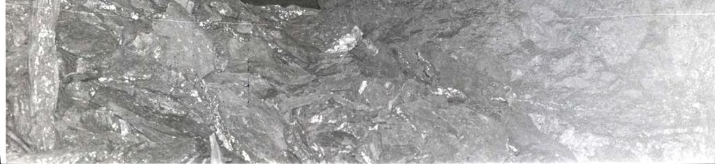
7 Difficult Mine Conditions Lower mine seam covers 500 acres Gypsum mine seam 16 feet Mine voids average 10 feet, but locally may be up to 15 feet in height Deepest section (Ahrens) 85 feet Room and pillar, with 15 x15 pillars and rooms span 20 feet Overlain by feet of dolomite, shale, and gypsum


8
9

10
11

12


13

14
15 Purpose & Need Goals Minimize Community Impacts Airport, residential properties, large-scale camping facilities, cemeteries and municipal properties in project area Minimize environmental impacts Project be consistent with existing local plans
16 Purpose & Need Goals Minimize Peak Season Traffic Disruptions SR-2 carries 18,000 vpd SR-2 is vital to tourist industry along Lake Erie Primary access to Marblehead peninsula and Ferry access to Middle & South Bass Secondary access to Cedar Point Minimize construction duration
17 Purpose & Need Goals Retain Limited Access Functionality SR-2 is important east-west corridor Limited access facility throughout Ottawa County Maintain Norfolk & Southern Rail

18


19


20

21 Detour Cost
22 Project Goals Understand the existing geologic conditions Verify and define the approximate limits of the mine Understand the risks involved with mitigating the existing conditions
23 Project Goals Develop and evaluate conceptual alternatives based on the Purpose & Need Remediate existing mines (SR-2 maintains current alignment) Land bridge (SR-2 maintains current alignment) Relocate/Shift SR-2
24 Geotechnical Investigation Surface geophysical Confirmation borings (21 Total) Laboratory testing Sonar modeling
25 Surface Geophysics to Help Identify Mine Boundaries Approach included two surface geophysical methods: Microgravity primarily to map mine boundaries Resistivity Imaging primarily to identify other geologic variability and to aid in interpreting the gravity data

26 Microgravity Gravity measurements detect changes in the earth s gravitational field caused by local changes in the density of the soil and rock or engineered structures.

27 Mapping of Top of Rock
 2400 2200 2000 1800 1600 1400 1200 1000 800 Gravity Contour Map Terrain and Fill Corrected 120 100 80")

28 Mapping Old Paleo-Collapse Sinkholes Easting (feet) Northing (feet) Gravity Contour Map Terrain and Fill Corrected uGal Contour Interval Northing (feet) Buried paleocollapse Easting (feet)

29 Detection of Large Conduits

30 Map the Presence of Mines
31 Limitations Only detects features with a density contrast Supporting data must be used to constrain gravity models (non-unique modeling) Vibrations can produce noise in data (e.g. distant earthquakes, wind, waves, vehicles, construction, etc.) Nearby topography can introduce noise if not accounted for in the data processing
32 Soil Forward Model of Gravity Response Over Expected Mine Conditions Bedrock Mine 85 ft deep, 15 ft high

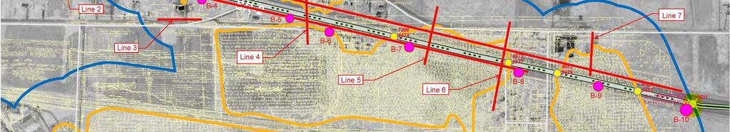
33 Planned Geophysical Lines Test Phase Data


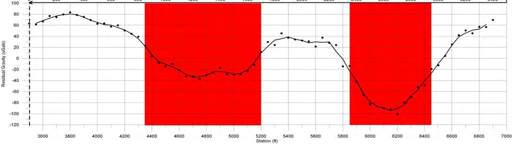
34 - Fairly insensitive to depth due to large planar target - Very sensitive to thickness 11 ft assumes water-filled, could be up to 15 ft or as little as 7 ft, if air-filled Microgravity Test Data

35 Microgravity Data Line 1

36 Microgravity Results
37 Results from Microgravity Alone Response from mine, even at deepest provided a good target for microgravity Top of rock is deeper to east Mine is deeper to east Thickness of mine varies 2 to 12 ft, getting thinner to northwest

38 SUBSURFACE INVESTIGATION PLAN
39 Sonar Deployment Sonar deployed by hoist from tripod Sonar linked mechanically to the surface providing a physical orientation Horizontal sonar scans are collected at 1 ft or less incremental elevations Computer controls and logs data from sonar unit

40 Statistics 200,000 cu ft of void modeled 1800 linear ft of mine corridor modeled Mine conditions revealed in models
41 Sonar Modeling Process Collect horizontal sonar scans in small vertical increments in the field Combine scans to create a 3 dimensional model of the flooded void Translate and orient the model into site coordinates Produce plots, models, and analyze the model for volume View 2-D and 3-D data to access the remaining mine structures Align the features in the model with the mine map features


42 Sonar plot from field P-18 Sonar plot for 1 elevation as viewed in the field Red circles represent 36 ft per division in this scan Red cross hairs show the borehole location center of the scan Center to edge is approximately 200 ft Dark areas are reflections from surfaces in the mine. Crisp black lines are from vertical surfaces and fuzzy lines like shown to the left show slope of roof.
43 Composite plot of sonar scans P-17


44 P-17 sonar aligned on mine map
45 Sonar Results Confirmation and orientation of old mine maps through feature matching with sonar models Revealed areas of collapse and areas where pillars are still intact Larger models verified dip of the seam where both roof and floor were visible Sonar data was gathered 200 ft from some of the boreholes The water was filled with suspended particles and visibility was minimal. The camera was only useful to verify the water level and to confirm blockage or bottom.
46 Alternative Development Minie Stabilization (SR-2 maintains current alignment) Land bridge (SR-2 maintains current alignment) Relocate/Shift SR-2

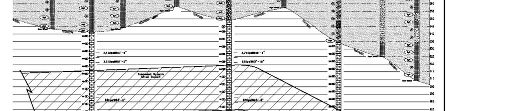
47 SR 2 GENERAL SUBSURFACE PROFILE

48 BORING INJECTION PLAN

49 MINE STABILIZATION PLAN

50 Area A $ 3,654, vertical holes, 20 angled holes, 7100 yds³ Barrier Concrete Grout, 14,500 yds³ Production grout, Mob/Demob + Misc.

51 Area B - $ 3,204, vertical holes, 19 angled holes, 14,074 yds³ Barrier Concrete Grout, 10,100 yds³ Production grout, Mob/Demob + Misc.

52 Area C - $ 9,791, vertical holes, 109 angled holes, 23,889 yds³ Barrier Concrete Grout, 51,834 yds³ Production grout, Mob/Demob + Misc.

53 Area D - $ 9,513, vertical holes, 82 angled holes, 18,333 yds³ Barrier Concrete Grout, 52,620 yds³ Production grout, Mob/Demob + Misc.
54 Area A $ 3,654, Grouting Costs 107 vertical holes, 20 angled holes, 7100 yds³ Barrier Concrete Grout, 14,500 yds³ Production grout, Mob/Demob + Misc. Area B - $ 3,204, vertical holes, 19 angled holes, 14,074 yds³ Barrier Concrete Grout, 10,100 yds³ Production grout, Mob/Demob + Misc. Area C - $ 9,791, vertical holes, 109 angled holes, 23,889 yds³ Barrier Concrete Grout, 51,834 yds³ Production grout, Mob/Demob + Misc. Area D - $ 9,513, vertical holes, 82 angled holes, 18,333 yds³ Barrier Concrete Grout, 52,620 yds³ Production grout, Mob/Demob + Misc. TOTAL MINE REMEDIATION $ 26,163,544

55 Land Bridge Alternative Segmental Concrete Box Girder

56 Steel Plate Girder Land Bridge Alternative


57 Shift SR-2: Alternative 3A Overpass reconstructed Avoid Mines Modify existing roadway Modify existing roadway


58 Shift SR-2: Alternative 3B Avoid Mines Overpass reconstructed Modify existing roadway Modify existing roadway

59 Shift SR-2: Alternative 3C Overpass reconstructed Avoid Mines Maintain existing connectivity Constructed on existing mines
60 Shift SR-2: Alternative 3D Overpass maintained Maintain existing connectivity Constructed on existing mines
61 Conclusions and Recommendations Land Bridge Eliminated from further consideration High construction cost Long construction schedule High impact to existing traffic Mine Stabilzation Continued for further consideration Minimally satisfy all key elements of the Purpose & Need
62 Conclusions and Recommendations Shift SR-2: Alt. 3A and 3B Eliminated from further consideration High right-of-way needs Long construction schedule Alter existing roadway network Shift SR-2: Alt. 3A and 3B Continued for further consideration Minimally satisfy all key elements of the Purpose & Need
63 Next Steps PREPARE A DESIGN FOR A SMALL PILOT PROJECT, THERE IS A CONCERN REGARDING THE GROUTING AND BARRIERS FOR VOIDS POSSIBLY EXCEEDING 13 FEET IN HEIGHT EVALUATE THE RESULTS OF THE PILOT PROJECT TO DETERMINE THE MOST FEASIBLE APPROACH TO STABILIZING THESE MASSIVE VOIDS DEVELOP DESIGN DOCUMENTS IN ACCORDANCE WITH THE BEST ALTERNATIVE
64 QUESTIONS?
Engineering Geophysical Application to Mine Subsidence Risk Assessment
 Engineering Geophysical Application to Mine Subsidence Risk Assessment By: Kanaan Hanna, Sr. Mining Engineer Steve Hodges, Sr. Geophysicist Jim Pfeiffer, Sr. Geophysicist Dr. Keith Heasley, Professor West
LOCATING AND CHARACTERIZING ABANDONED MINES USING MICROGRAVITY by Richard C. Benson 1, Ronald D. Kaufmann 1, Lynn Yuhr 1, Richard Hopkins 2 ABSTRACT
 LOCATING AND CHARACTERIZING ABANDONED MINES USING MICROGRAVITY by Richard C. Benson 1, Ronald D. Kaufmann 1, Lynn Yuhr 1, Richard Hopkins 2 ABSTRACT Surface geophysical methods can be an important part
Geophysical Exploration in Water Resources Assessment. John Mundell, P.E., L.P.G., P.G. Ryan Brumbaugh, L.P.G. Mundell & Associates, Inc.
 Geophysical Exploration in Water Resources Assessment John Mundell, P.E., L.P.G., P.G. Ryan Brumbaugh, L.P.G. Mundell & Associates, Inc. Presentation Objective Introduce the use of geophysical survey methods
Development of geophysical investigation for verifying treatment efficiency of underground cavities
 Development of geophysical investigation for verifying treatment efficiency of underground cavities Hasan A. Kamal* Kuwait Institute for Scientific Research, Infrastructure Risk and Reliability Program,
Applied Geophysics for Environmental Site Characterization and Remediation
 Applied Geophysics for Environmental Site Characterization and Remediation MSECA Webinar September 24, 2015 John Mundell, P.E., L.P.G. Ryan Brumbaugh, L.P.G. MUNDELL & ASSOCIATES, INC. Webinar Objective
KARST MAPPING WITH GEOPHYSICS AT MYSTERY CAVE STATE PARK, MINNESOTA
 KARST MAPPING WITH GEOPHYSICS AT MYSTERY CAVE STATE PARK, MINNESOTA By Todd A. Petersen and James A. Berg Geophysics Program Ground Water and Climatology Section DNR Waters June 2001 1.0 Summary A new
IMAGING OF DEEP SINKHOLES USING THE MULTI-ELECTRODE RESISTIVITY IMPLANT TECHNIQUE (MERIT) CASE STUDIES IN FLORIDA
 CASE STUDIES IN FLORIDA") IMAGING OF DEEP SINKHOLES USING THE MULTI-ELECTRODE RESISTIVITY IMPLANT TECHNIQUE (MERIT) CASE STUDIES IN FLORIDA David Harro The G3 Group, 2509 Success Drive, Suite 1, Odessa, FL 33556, david.harro@geo3group.com
IMAGING OF DEEP SINKHOLES USING THE MULTI-ELECTRODE RESISTIVITY IMPLANT TECHNIQUE (MERIT) CASE STUDIES IN FLORIDA David Harro The G3 Group, 2509 Success Drive, Suite 1, Odessa, FL 33556, david.harro@geo3group.com
3.12 Geology and Topography Affected Environment
 3 Affected Environment and Environmental Consequences 3.12 Geology and Topography 3.12.1 Affected Environment 3.12.1.1 Earthquakes Sterling Highway MP 45 60 Project Draft SEIS The Kenai Peninsula is predisposed
PART I A BRIEF SUMMARY OF SIX ROADWAY INVESTIGATIONS IN KARST
 METHODS USED TO CARRY OUT SIX ROADWAY INVESTIGATIONS OF SINKHOLES Richard C. Benson Technos, Inc. 3333 NW 21 st Street, Miami FL 33142 info@technos-inc.com ABSTRACT Karst conditions are a prevalent problem
GM 1.4. SEG/Houston 2005 Annual Meeting 639
 storage recovery project in Leyden, Colorado Kristofer Davis *, Yaoguo Li, Michael Batzle, and Bob Raynolds** Center for Gravity, Electrical, and Magnetic Studies, Department of Geophysics, Colorado School
Geologging Imagery, Applications and Geological Interpretation. Shea Altadonna 1, Jim Fulton 2, E.I.T.
 Geologging Imagery, Applications and Geological Interpretation Shea Altadonna 1, Jim Fulton 2, E.I.T. 1 Geologist, Advanced Construction Techniques Inc. 1000 N. West St. Ste 1200, Wilmington, DE 19801;
3/15/17. #22 - Subsidence - Rapid Sinkhole at Winter Park, FL in Rapid Subsidence Defined and Illustrated
 Web Exercise #3 (Volcanoes) Late- closing at 1:00 today Web Exercise #4 (Landslides) DUE WEDNESDAY Use Hazard City to answer matching question in Part II #22 - Subsidence - Rapid Sinkhole at Winter Park,
Background. Valley fills Sites in the Area. Construction over Mine Spoil Fills
 Construction over Mine Spoil Fills Wayne A. Karem, PhD, PE, PG, D.GE 2014 KSPE Annual Conference Background Strip mining; mountaintop and contour mining Creates huge quantities of mine spoil The mine spoil
Association of Environmental & Engineering Geologists (AEG) To join AEG: Student membership is Free! Ask about our scholarships.
 To join AEG: Student membership is Free! Ask about our scholarships.") Association of Environmental & Engineering Geologists (AEG) To join AEG: www.aegweb.org/join Student membership is Free! Ask about our scholarships. What is the Association of Environmental & Engineering
Association of Environmental & Engineering Geologists (AEG) To join AEG: www.aegweb.org/join Student membership is Free! Ask about our scholarships. What is the Association of Environmental & Engineering
GEOPHYSICAL IMAGING TO ENHANCE ANALYSIS, DESIGN AND DRILLING OF LARGE-SCALE GEOTHERMAL SYSTEMS. Abstract
 GEOPHYSICAL IMAGING TO ENHANCE ANALYSIS, DESIGN AND DRILLING OF LARGE-SCALE GEOTHERMAL SYSTEMS John A. Mundell, Mundell & Associates, Inc., Indianapolis, Indiana Gabriel Hebert, Mundell & Associates, Inc.,
10. GEOTECHNICAL EXPLORATION PROGRAM
 Geotechnical site investigations should be conducted in multiple phases to obtain data for use during the planning and design of the tunnel system. Geotechnical investigations typically are performed in
THE NEED FOR AN ADDITIONAL SPILLWAY AT THE SANFORD DAM BOILING SPRING LAKES, NC. Presentation for The Brunswick County Commissioners April 20, 2015
 THE NEED FOR AN ADDITIONAL SPILLWAY AT THE SANFORD DAM BOILING SPRING LAKES, NC Presentation for The Brunswick County Commissioners April 20, 2015 The Sanford Dam Earth Dam constructed in 1961 Drainage
An Introduction to Field Explorations for Foundations
 An Introduction to Field Explorations for Foundations J. Paul Guyer, P.E., R.A. Paul Guyer is a registered mechanical engineer, civil engineer, fire protection engineer and architect with over 35 years
Geology, Soils, and Seismicity
 Section 3.8 Geology, Soils, and Seismicity Introduction This section generally evaluates the effects of the alternatives analyzed in this Supplemental DEIS with regard to geology, soils and seismicity.
GEOLOGY, SOILS, AND SEISMICITY
 4.9 GEOLOGY, SOILS, AND SEISMICITY 4.9.1 Introduction Information about the geological conditions and seismic hazards in the study area was summarized in the FEIR, and was based on the Geotechnical Exploration
ambiguity in earth sciences IESO Geophysics Section Eddy hartantyo, Lab Geofisika FMIPA UGM
 ambiguity in earth sciences IESO Geophysics Section Eddy hartantyo, Lab Geofisika FMIPA UGM Pelatihan Tahap II IESO Teknik Geologi UGM Februari 2009 1 Introduction Photos from http://www.eegs.org/whatis/
SLOPE STABILITY EVALUATION AND ACCEPTANCE STANDARDS
 INFORMATION BULLETIN / PUBLIC - BUILDING CODE REFERENCE NO.: LAMC 98.0508 Effective: 1-26-84 DOCUMENT NO. P/BC 2002-049 Revised: 11-1-02 Previously Issued As: RGA #1-84 SLOPE STABILITY EVALUATION AND ACCEPTANCE
SLOPE STABILITY EVALUATION AND ACCEPTANCE STANDARDS
 INFORMATION BULLETIN / PUBLIC - BUILDING CODE REFERENCE NO.: LABC 7006.3, 7014.1 Effective: 01-01-2017 DOCUMENT NO.: P/BC 2017-049 Revised: 12-21-2016 Previously Issued As: P/BC 2014-049 SLOPE STABILITY
US82 ROCKFALL MITIGATION PROJECT May, BY Mohammed Ghweir Engineering Geologist Geotechnical Design Section New Mexico DOT
 US82 ROCKFALL MITIGATION PROJECT May, 2009 BY Mohammed Ghweir Engineering Geologist Geotechnical Design Section New Mexico DOT SACRAMENTO MTS Rock Fall Signs Back Ground US82 Connects the Town of Alamogordo,
THE QUATERNARY GEOLOGY OF NEWARK BAY AND KILL VAN KULL CHANNEL, NEW YORK AND NEW JERSEY. and
 THE QUATERNARY GEOLOGY OF NEWARK BAY AND KILL VAN KULL CHANNEL, NEW YORK AND NEW JERSEY Stephanie Beda, W. Bruce Ward, William Murphy, Robert Fleming, Gary Fleming, Beckett Boyd Earthworks LLC 27 Glen
SEISMIC REFRACTION SURVEY RIPPABILITY STUDY
 SEISMIC REFRACTION SURVEY RIPPABILITY STUDY US 95A SILVER SPRINGS to FERNLEY LYON COUNTY August 2008 E.A. 73455 MATERIALS DIVISION SEISMIC REFRACTION SURVEY RIPPABILITY STUDY LYON COUNTY US 95A SILVER
Geophysical Site Investigation (Seismic methods) Amit Prashant Indian Institute of Technology Gandhinagar
 Amit Prashant Indian Institute of Technology Gandhinagar") Geophysical Site Investigation (Seismic methods) Amit Prashant Indian Institute of Technology Gandhinagar Short Course on Geotechnical Aspects of Earthquake Engineering 04 08 March, 2013 Seismic Waves
Geophysical Site Investigation (Seismic methods) Amit Prashant Indian Institute of Technology Gandhinagar Short Course on Geotechnical Aspects of Earthquake Engineering 04 08 March, 2013 Seismic Waves
High Resolution Geophysics: A Better View of the Subsurface. By John Jansen, P.G., Ph.D., Aquifer Science and Technology
 High Resolution Geophysics: A Better View of the Subsurface By John Jansen, P.G., Ph.D., Aquifer Science and Technology Geologist Use Only Part of the Information Available To Them Most Geologist rely
Measurement of effective stress shear strength of rock
 Measurement of effective stress shear strength of rock R. A. Failmezger, P.E., F. ASCE In-Situ Soil Testing, L.C., Lancaster, Virginia USA D. J. White, Ph. D., P.E. Iowa State University, Ames, Iowa USA
ELECTRICAL RESISTIVITY SURVEYS AT THE ANDERSON RESIDENCE SITE, PORT CLYDE, ME. For: St.Germain-Collins
 ELECTRICAL RESISTIVITY SURVEYS AT THE ANDERSON RESIDENCE SITE, PORT CLYDE, ME For: St.Germain-Collins 4 Union Street, Suite 3 Bangor, Maine 441 July, 218 ELECTRICAL RESISTIVITY SURVEYS AT THE ANDERSON
GEOTECHNICAL ENGINEERING II. Subject Code : 06CV64 Internal Assessment Marks : 25 PART A UNIT 1
 GEOTECHNICAL ENGINEERING II Subject Code : 06CV64 Internal Assessment Marks : 25 PART A UNIT 1 1. SUBSURFACE EXPLORATION 1.1 Importance, Exploration Program 1.2 Methods of exploration, Boring, Sounding
Appendix I. Dredged Volume Estimates. Draft Contractor Document: Subject to Continuing Agency Review
 Appendix I Dredged Volume Estimates Draft Contractor Document: Subject to Continuing Agency Review Interoffice Correspondence Date: April 6, 2007 To: L. Bossi (WHI) Copy: S. Thompson (WHI), B. Fidler (NNJ)
Highland Lake Bathymetric Survey
 Highland Lake Bathymetric Survey Final Report, Prepared For: The Town of Highland Lake 612 Lakeshore Drive Oneonta, AL 35121 Prepared By: Tetra Tech 2110 Powers Ferry Road SE Suite 202 Atlanta, GA 30339
25th International Conference on Ground Control in Mining
 ANALYTICAL INVESTIGATION OF SHAFT DAMAGES AT WEST ELK MINE Tim Ross, Senior Associate Agapito Associates, Inc. Golden, CO, USA Bo Yu, Senior Engineer Agapito Associates, Inc. Grand Junction, CO, USA Chris
High Resolution Seismic Reflection Investigation of Salt Dissolution Features in Kansas
 High Resolution Seismic Reflection Investigation of Salt Dissolution Features in Kansas Neil M. Croxton 1 and Robert W. Henthorne 2 1 Kansas Department of Transportation, Regional Geologist, northwest
Amistad Dam Investigation and Oversight: Karst- Founded Dam on the USA-Mexico Border
 Amistad Dam Investigation and Oversight: Karst- Founded Dam on the USA-Mexico Border Brook Brosi, CPG, PG USACE Lisa Nowicki Perks, PG USACE Kimberly Heenan, PE AECOM US Army Corps of Engineers BUILDING
Preliminary Geotechnical Evaluation Gooseberry Point Pedestrian Improvements Whatcom County, Washington SITE AND PROJECT DESCRIPTION
 File No. 12-100 Geotechnical & Earthquake Engineering Consultants Mr. Kevin Brown, P.E. Gray & Osborne, Inc. 3710 168 th Street NE, Suite B210 Arlington, Washington 98223 Subject: Draft Report Preliminary
patersongroup Consulting Engineers April 20, 2010 File: PG1887-LET.01R Novatech Engineering Consultants Suite 200, 240 Michael Cowpland Drive
 patersongroup April 20, 2010 File: PG1887-LET.01R Novatech Engineering Consultants Suite 200, 240 Michael Cowpland Drive Ottawa, Ontario K2M 1P6 Attention: Mr. Adam Thompson Consulting Engineers 28 Concourse
A test boring program was utilized in this study in order to verify. existing information, and to obtain otherwise unavailable data that was
 TEST BORING RESULTS A test boring program was utilized in this study in order to verify existing information, and to obtain otherwise unavailable data that was considered vital for the formulation of an
LECTURE 10. Module 3 : Field Tests in Rock 3.6 GEOPHYSICAL INVESTIGATION
 LECTURE 10 3.6 GEOPHYSICAL INVESTIGATION In geophysical methods of site investigation, the application of the principles of physics are used to the study of the ground. The soil/rock have different characteristics
FINAL REPORT GEOPHYSICAL INVESTIGATION WATER TOWER NO. 6 SITE PLANT CITY, FL
 APPENDIX B FINAL REPORT GEOPHYSICAL INVESTIGATION WATER TOWER NO. 6 SITE PLANT CITY, FL Prepared for Madrid Engineering Group, Inc. Bartow, FL Prepared by GeoView, Inc. St. Petersburg, FL February 28,
2. Initial Summary of Preliminary Expert Opinion of Converse and Psomas Reports
 UNITED WALNUT TAXPAYERS PRELIMINARY REVIEW OF NEGATIVE GEOTECHNICAL AND GEOLOGICAL ASPECTS OF CONSTRUCTING EARTHFILL PAD FOR A SOLAR FARM ON THE WEST PARCEL - DRAFT 1. Introduction A licensed Engineering
Earthquakes and Earth s Interior
 - What are Earthquakes? Earthquakes and Earth s Interior - The shaking or trembling caused by the sudden release of energy - Usually associated with faulting or breaking of rocks - Continuing adjustment
FINAL REPORT GEOPHYSICAL INVESTIGATION VILLAGE ALHAMBRA RETENTION POND SITE THE VILLAGES, FLORIDA
 FINAL REPORT GEOPHYSICAL INVESTIGATION VILLAGE ALHAMBRA RETENTION POND SITE THE VILLAGES, FLORIDA Prepared for Andreyev Engineering, Inc. Oxford, FL Prepared by GeoView, Inc. St. Petersburg, FL August
Geophysics for Environmental and Geotechnical Applications
 Geophysics for Environmental and Geotechnical Applications Dr. Katherine Grote University of Wisconsin Eau Claire Why Use Geophysics? Improve the quality of site characterization (higher resolution and
Land Subsidence. Land subsidence is defined as the lowering of the land surface.
 Land Subsidence Land subsidence is defined as the lowering of the land surface. Many different factors can cause the land surface to subside. Subsidence can occur rapidly due to: a sinkhole or under ground
Subsurface laser scanning and multibeam sonar void surveys What really does lie beneath and where exactly? Mitigating your Risk
 Subsurface laser scanning and multibeam sonar void surveys What really does lie beneath and where exactly? Mitigating your Risk UNDERGROUND CAVITY SURVEYS C-ALS (Cavity Auto Laser Scanner) - DRY Deployed
Hydraulic Impacts of Limestone Quarries and Gravel Pits. Jeff Green Minnesota DNR-Division of Ecological & Water Resources
 Hydraulic Impacts of Limestone Quarries and Gravel Pits Jeff Green Minnesota DNR-Division of Ecological & Water Resources The Hydraulic Impacts of Limestone Quarries and Gravel Pits Study was funded by
Seismic tests at Southern Ute Nation coal fire site
 Seismic tests at Southern Ute Nation coal fire site Sjoerd de Ridder and Seth S. Haines ABSTRACT We conducted a near surface seismic test at the Southern Ute Nation coal fire site near Durango, CO. The
Rock Scaling Recommendations Logan Creek Drive Cut Slope
 Rock Scaling Recommendations Logan Creek Drive Cut Slope US 50, Milepost DO 8.47 to DO 8.61 Douglas County, Nevada January 2008 MATERIALS DIVISION STATE OF NEVADA DEPARTMENT OF TRANSPORTATION MATERIALS
Rogun Hydropower Project
 Rogun Hydropower Project Dam site Geological investigations in the Downstream Right Bank Ascencio Lara Coyne et Bellier Almaty, 11-12 February 2013 Objectives of the presentation As the stability conditions
Downtown Anchorage Seismic Risk Assessment & Land Use Regulations to Mitigate Seismic Risk
 Prepared for: The Municipality of Anchorage Planning Department and the Geotechnical Advisory Commission Downtown Anchorage Seismic Risk Assessment & Land Use Regulations to Mitigate Seismic Risk Prepared
Marine Geophysical Methods: What Can and Cannot Be Done to Iden8fy Hazards to Dredging & Marine Construc8on
 Marine Geophysical Methods: What Can and Cannot Be Done to Iden8fy Hazards to Dredging & Marine Construc8on Marine Geophysics Sham or Savior? Seen alternatively as the silver bullet or snake oil, marine
Department of National Defence B-Jetty Reconstruction
 Department of National Defence B-Jetty Reconstruction CFB Esquimalt, BC Presented by: Stantec & Golder Associates February 2, 2016 Agenda 1 B-Jetty Project Background 2 Distinguishing Project Features
BOS 100 Overburden and Bedrock Groundwater Remediation Former Dry Cleaning Facility
 BOS 100 Overburden and Bedrock Groundwater Remediation Former Dry Cleaning Facility Site Description Location Central Kentucky Site Use Retail Shopping Center Geologic Setting Inner Bluegrass Bedrock Ordovician
III. FORECASTED GROWTH
 III. FORECASTED GROWTH In order to properly identify potential improvement projects that will be required for the transportation system in Milliken, it is important to first understand the nature and volume
DEEP KARST CONDUITS, FLOODING, AND SINKHOLES: LESSONS FOR THE AGGREGATES INDUSTRY
 DEEP KARST CONDUITS, FLOODING, AND SINKHOLES: LESSONS FOR THE AGGREGATES INDUSTRY James L. Lolcama, Harvey A. Cohen, & Matthew J. Tonkin, S.S. Papadopulos & Associates, Inc., 7944 Wisconsin Ave., Bethesda,
ENGINEER S CERTIFICATION OF FAULT AREA DEMONSTRATION (40 CFR )
") PLATTE RIVER POWER AUTHORITY RAWHIDE ENERGY STATION BOTTOM ASH TRANSFER (BAT) IMPOUNDMENTS LARIMER COUNTY, CO ENGINEER S CERTIFICATION OF FAULT AREA DEMONSTRATION (40 CFR 257.62) FOR COAL COMBUSTION RESIDUALS
PLATTE RIVER POWER AUTHORITY RAWHIDE ENERGY STATION BOTTOM ASH TRANSFER (BAT) IMPOUNDMENTS LARIMER COUNTY, CO ENGINEER S CERTIFICATION OF FAULT AREA DEMONSTRATION (40 CFR 257.62) FOR COAL COMBUSTION RESIDUALS
GPR AS A COST EFFECTIVE BEDROCK MAPPING TOOL FOR LARGE AREAS. Abstract
 GPR AS A COST EFFECTIVE BEDROCK MAPPING TOOL FOR LARGE AREAS Dr. Jutta L. Hager, Hager GeoScience, Inc., Waltham, MA Mario Carnevale, Hager GeoScience, Inc., Waltham, MA Abstract Hager GeoScience, Inc.
Prepared for: Cargill, Inc. 191 PortLand Point Road Lansing, New York 14882
 CARGILL CAYUGA MINE MINED LAND USE PLAN VOLUME I Prepared for: Cargill, Inc. 191 PortLand Point Road Lansing, New York 14882 Prepared by: Spectra Environmental Group, Inc. 19 British American Boulevard
UTC R161. Geotechnical Site Characterization of Transportation Construction Sites and Structures. Neil L. Anderson. Derek B. Apel.
 Geotechnical Site Characterization of Transportation Construction Sites and Structures Assessment Of Karst Activity At Highway Construction Sites In Greene And Jefferson Counties, Missouri, Using The Electrical
Delineation of Zones at Risk from Groundwater Inflows at an Underground Platinum Mine in South Africa
 Delineation of Zones at Risk from Groundwater Inflows at an Underground Platinum Mine in South Africa Mr Andreas Stoll andreas.stoll@erm.com Environmental Resources Management Swiss GmbH (ERM), Switzerland
a z41. COMMONWEALTH OF AUSTRALIA DEPARTMENT OF NATIONAL DEVELOPMENT BUREAU OF MINERAL RESOURCES, GEOLOGY AND GEOPHYSICS RECORD 1961 No.
 a z41. COMMONWEALTH OF AUSTRALIA ff..4 *.re /Veis DEPARTMENT OF NATIONAL DEVELOPMENT BUREAU OF MINERAL RESOURCES, GEOLOGY AND GEOPHYSICS RECORD 1961 No. 66 RED TANK BORE GRAVITY SURVEY, PLENTY RIVER, N.T.
NOA ASSESSMENT HARRIS QUARRY MENDOCINO COUNTY, CALIFORNIA TABLE OF CONTENTS
 NOA ASSESSMENT HARRIS QUARRY MENDOCINO COUNTY, CALIFORNIA TABLE OF CONTENTS Introduction... 1 Scope of Services... 1 Project Location and Description... 1 Geologic Setting... 1 Regional Geology... 1 Site
General Geologic Setting and Seismicity of the FHWA Project Site in the New Madrid Seismic Zone
 General Geologic Setting and Seismicity of the FHWA Project Site in the New Madrid Seismic Zone David Hoffman University of Missouri Rolla Natural Hazards Mitigation Institute Civil, Architectural & Environmental
June 9, R. D. Cook, P.Eng. Soils Engineer Special Services Western Region PUBLIC WORKS CANADA WESTERN REGION REPORT ON
 PUBLIC WORKS CANADA WESTERN REGION REPORT ON GEOTECHNICAL INVESTIGATION PROPOSED MARTIN RIVER BRIDGE MILE 306.7 MACKENZIE HIGHWAY Submitted by : R. D. Cook, P.Eng. Soils Engineer Special Services Western
Hydrogeological Assessment for Part of Lots 2 and 3, Concession 5, Township of Thurlow, County of Hastings 1.0 INTRODUCTION. 1.
 February 10,2017 25506400 Ontario Ltd. Foxboro, ON Attention: Brad Newbatt Re: Hydrogeological Assessment for Part of Lots 2 and 3, Concession 5, Township of Thurlow, County of Hastings 1.0 INTRODUCTION
LANDSLIDES IN THE WHITE MOUNTAIN (GEOTECHNICAL STUDIES AND ENGINEERING TESTS)
") J. Al Azhar University Gaza 2004, Vol. 7, NO. 2 P 15-26 LANDSLIDES IN THE WHITE MOUNTAIN (GEOTECHNICAL STUDIES AND ENGINEERING TESTS) Isam G. Jardaneh (1), Jalal Al-Dabeek (2), Abdel hakeem Al-Jawhari
J. Al Azhar University Gaza 2004, Vol. 7, NO. 2 P 15-26 LANDSLIDES IN THE WHITE MOUNTAIN (GEOTECHNICAL STUDIES AND ENGINEERING TESTS) Isam G. Jardaneh (1), Jalal Al-Dabeek (2), Abdel hakeem Al-Jawhari
Geophysical Case studies From Texas
 Geophysical Case studies From Texas 1 PRESENTATION OUTLINE Active Growth Faults in Metropolitan Houston 1. Hockley 2. Tomball 3. Long Point 4. Pearland Foundation Case Studies Karst Geophysics in Austin:
Bedrock Associated with the Ranch House at the Tallgrass Prairie National Preserve, Chase County, Kansas
 Bedrock Associated with the Ranch House at the Tallgrass Prairie National Preserve, Chase County, Kansas KGS OPEN-FILE REPORT 2008-10 KANSAS GEOLOGICAL SURVEY 1930 Constant Ave. - Campus West Lawrence,
CHAPTER GEOLOGICALLY HAZARDOUS AREAS Applicability Regulations.
 CHAPTER 19.07 GEOLOGICALLY HAZARDOUS AREAS 19.07.010 Applicability. Geologically hazardous areas may pose a threat to the health and safety of citizens when incompatible development is sited in areas of
Geotechnical Aspects of the Ohio River Bridges Project
 Geotechnical Aspects of the Ohio River Bridges Project Mark A. Litkenhus, PE Sr. Geotechnical Engineer Stephen H. Bickel, PE Sr. Geotechnical Engineer STGEC Ohio River Bridges at Louisville Geotechnical
LIQUEFACTION OF EARTH EMBANKMENT DAMS TWO CASE HISTORIES: (1) LIQUEFACTION OF THE EMBANKMENT SOILS, AND (2) LIQUEFACTION OF THE FOUNDATIONS SOILS
 LIQUEFACTION OF THE EMBANKMENT SOILS, AND (2) LIQUEFACTION OF THE FOUNDATIONS SOILS") LIQUEFACTION OF EARTH EMBANKMENT DAMS TWO CASE HISTORIES: (1) LIQUEFACTION OF THE EMBANKMENT SOILS, AND (2) LIQUEFACTION OF THE FOUNDATIONS SOILS Antonio Fernandez, Ph.D. 1 ABSTRACT Paul C. Rizzo Associates,
LIQUEFACTION OF EARTH EMBANKMENT DAMS TWO CASE HISTORIES: (1) LIQUEFACTION OF THE EMBANKMENT SOILS, AND (2) LIQUEFACTION OF THE FOUNDATIONS SOILS Antonio Fernandez, Ph.D. 1 ABSTRACT Paul C. Rizzo Associates,
HISTORY OF CONSTRUCTION FOR EXISTING CCR SURFACE IMPOUNDMENT PLANT GASTON ASH POND 40 CFR (c)(1)(i) (xii)
(1)(i) (xii)") HISTORY OF CONSTRUCTION FOR EXISTING CCR SURFACE IMPOUNDMENT PLANT GASTON ASH POND 40 CFR 257.73(c)(1)(i) (xii) (i) Site Name and Ownership Information: Site Name: E.C. Gaston Steam Plant Site Location:
HISTORY OF CONSTRUCTION FOR EXISTING CCR SURFACE IMPOUNDMENT PLANT GASTON ASH POND 40 CFR 257.73(c)(1)(i) (xii) (i) Site Name and Ownership Information: Site Name: E.C. Gaston Steam Plant Site Location:
THE OHIO JOURNAL OF SCIENCE
 THE OHIO JOURNAL OF SCIENCE VOL. LIII MARCH, 1953 No. 2 SUBSURFACE STUDY OF GLACIAL DEPOSITS AT CLEVELAND, OHIO C. T. BAGLEY Sverdrup & Parcel, Inc., Consulting Engineers, St. Lotus, Mo. The soil 1 strata
 SHEET TITLE: DRAWN BY: J.M.CLARK FILE NO. CHECKED BY: W.S. JORDAN APPROVED BY: DATE: FIGURE SHEET TITLE: DRAWN BY: J.M.CLARK FILE NO. CHECKED BY: W.S. JORDAN APPROVED BY: DATE: FIGURE SPOTLIGHT Technical
Guidelines for Site-Specific Seismic Hazard Reports for Essential and Hazardous Facilities and Major and Special-Occupancy Structures in Oregon
 Guidelines for Site-Specific Seismic Hazard Reports for Essential and Hazardous Facilities and Major and Special-Occupancy Structures in Oregon By the Oregon Board of Geologist Examiners and the Oregon
BUFFALO RIVER COALITION PO Box 101, Jasper, AR (870)
") BUFFALO RIVER COALITION PO Box 101, Jasper, AR 72641 (870) 446-5783 buffalowatershed@gmail.com Presentation before Arkansas Pollution Control and Ecology Commission, April 29, 2016 by Richard Mays on behalf
BUFFALO RIVER COALITION PO Box 101, Jasper, AR 72641 (870) 446-5783 buffalowatershed@gmail.com Presentation before Arkansas Pollution Control and Ecology Commission, April 29, 2016 by Richard Mays on behalf
Seismic Reflection Imaging across the Johnson Ranch, Valley County, Idaho
 Seismic Reflection Imaging across the Johnson Ranch, Valley County, Idaho Report Prepared for the Skyline Corporation Lee M. Liberty Center for Geophysical Investigation of the Shallow Subsurface (CGISS)
5 Further Case Histories
 5 Further Case Histories Chapter outline Cavity/old workings detection Detailed pillar detection Near-surface cavity detection Dyke, sill and fault detection In-seam disruptions (lenses, etc.) Coal thickness
Geologic Hazards. Montour County Multi-jurisdictional. General. Earthquake
 Geologic Hazards General s are very rare in Pennsylvania and have caused little damage with no reported injuries or causalities. s that do occur in Pennsylvania happen deep within the Earth s crust. This
Central Florida Sinkhole Evaluation
 Central Florida Sinkhole Evaluation By Kathy M. Gray 1 Abstract: This paper presents a discussion of sinkhole risk evaluation in Central Florida. It is the culmination of more than 33 years of practice
Multi-Jurisdictional Hazard Mitigation Plan. Table C.10 The Richter Scale. Descriptor Richter Magnitude Earthquake Effects
 Geologic Hazards Earthquake Earthquakes are very rare in Pennsylvania and have caused little damage, with no reported injuries or causalities. Earthquakes that do occur in Pennsylvania happen deep within
FRACTURE TRACES AND PRODUCTIVITY OF MUNICIPAL WELLS IN THE MADISON LIMESTONE, RAPID CITY, SOUTH DAKOTA
 Proceedings of the South Dakota Academy of Science, Vol. 87 (2008) 261 FRACTURE TRACES AND PRODUCTIVITY OF MUNICIPAL WELLS IN THE MADISON LIMESTONE, RAPID CITY, SOUTH DAKOTA Perry H. Rahn Department of
TINTAGEL CASTLE FOOTBRIDGE OPTIONS APPRAISAL. Feasibility Report July 2014
 TINTAGEL CASTLE FOOTBRIDGE OPTIONS APPRAISAL Feasibility Report July 2014 THE SETTING LOCATION Proposed alignment of bridge 09 ALIGNMENT 01 03 02 04 05 07 09 Key 1. Lower Mainland Courtyard 06 2. Existing
Major Points in Introduction
 Near- Surface Processes and Resources John Louie - louie@seismo.unr.edu eismo. unr.edu Thomas Pratt tpratt@ocean.washington.edu ashington.edu Here is a Laundry List- With it, we can prioritize Major Points
The Following was Noted: US Army Corps of Engineers Philadelphia District Geotechnical Section, CENAP-EN-DG
 US Army Corps of Engineers Philadelphia District Geotechnical Section, CENAP-EN-DG Wanamaker Bldg, 7th Floor 100 Penn Square East Philadelphia, PA 19107-3396,USA Site Visit Report Date: Tuesday, Nov. 6,
GEOL4714 Final Exam Fall 2005, C. H. Jones instructor
 GEOL4714 Final Exam Fall 2005 p. 1 GEOL4714 Final Exam Fall 2005, C. H. Jones instructor Name: Student ID #: Feel free to use the back of the sheets for answers needing more space. (1) (10 pts) For each
REPORT OF GEOPHYSICAL SURVEY
 REPORT OF GEOPHYSICAL SURVEY KARST IMAGING STUDY CADIZ INDUSTRIAL PARK CADIZ, TRIGG COUNTY, KY MUNDELL PROJECT NO. M NOVEMBER, South Downey Avenue, Indianapolis, Indiana - Telephone --, Facsimile -- www.mundellassociates.com
Roadway Traffic Noise Feasibility Assessment. 315 Chapel Street. Ottawa, Ontario
 Roadway Traffic Noise Feasibility Assessment 315 Chapel Street Ottawa, Ontario REPORT: GWE17-002 - Traffic Noise Prepared For: Leanne Moussa Allsaints 10 Blackburn Avenue K1N 6P8 Ottawa, Ontario Prepared
Subsurface Geology of the Kennebec River
 Maine Geologic Facts and Localities July, 1998 Subsurface Geology of the Kennebec River 43 54 40.75 N, 69 48 29.01 W Text by Daniel B. Locke, Department of Agriculture, Conservation & Forestry 1 Map by
Which landscape best represents the shape of the valleys occupied by glaciers? A) B) C) D)
 B) C) D)") 1. Glaciers often form parallel scratches and grooves in bedrock because glaciers A) deposit sediment in unsorted piles B) deposit rounded sand in V-shaped valleys C) continually melt and refreeze D) drag
1. Glaciers often form parallel scratches and grooves in bedrock because glaciers A) deposit sediment in unsorted piles B) deposit rounded sand in V-shaped valleys C) continually melt and refreeze D) drag
Geophysical Methods to Map Subsurface Evaporite Features to Aid Roadway Geometric Design
 Geophysical Methods to Map Subsurface Evaporite Features to Aid Roadway Geometric Design Mike Homan, P.E. Terracon Consultants, Inc. 10930 East 56 th Street Tulsa, OK 74146 (918)-250-0461 mhhoman@terracon.com
LIGO Experience in Site Selection, Evaluation and Characterization
 1 of 21 - Asiri 06.24.02 LIGO Experience in Site Selection, Evaluation and Characterization 2 of 21 - Asiri 06.24.02 Content What is all about It is about LIGO Why should we care? It is an Experience with
THE MINISTRY OF ENERGY AND ENERGY INDUSTRIES MINERALS DIVISION MINE DESIGN TEMPLATE OPERATOR NAME: OPERATOR ADDRESS: PHONE NUMBER: FACSIMILE:
 THE MINISTRY OF ENERGY AND ENERGY INDUSTRIES MINERALS DIVISION MINE DESIGN TEMPLATE 1.0 GENERAL INFORMATION OPERATOR NAME: OPERATOR ADDRESS: PHONE NUMBER: FACSIMILE: NAME OF CONTACT: CELLULAR PHONE: EMAIL
Remedial Program. GE Hudson Falls Plant Site. GE Hudson Falls Plant Site. TDCS Status
 Updates on Remedial Programs at the GE Hudson Falls Plant Site and GE Fort Edward Plant Site GE Hudson Falls USEPA Community Advisory Group Meeting September 11, 2008 GE Fort Edward Division of Environmental
IV. ENVIRONMENTAL IMPACT ANALYSIS G. GEOLOGY AND SOILS
 IV. ENVIRONMENTAL IMPACT ANALYSIS G. GEOLOGY AND SOILS The following section is a summary of the geotechnical report conducted for the proposed project. The Report of Geotechnical Investigation Proposed
patersongroup Environmental Noise Control Study Proposed Multi-Storey Building 1136 Martime Way - Ottawa Prepared For
 Geotechnical Engineering patersongroup Environmental Engineering Hydrogeology Geological Engineering Materials Testing Building Science Archaeological Services Environmental Noise Control Study Proposed
Identified a possible new offset location where the customer is currently exploring drill options.
 GroundMetrics was hired to conduct a Full-Field Resistivity Survey for an oil and gas producer that needed to make crucial decisions to drive profitability at the location. The results saved them hundreds
Terrain Units PALEOGEOGRAPHY: LANDFORM CREATION. Present Geology of NYS. Detailed Geologic Map of NYS
 NYS TOPOGRAPHY Why so? PALEOGEOGRAPHY: LANDFORM CREATION Prof. Anthony Grande AFG 014 Present Geology of NYS Detailed Geologic Map of NYS Generalized Geology Detailed Geology Hot links to the fold out