Preliminary Geotechnical Evaluation Gooseberry Point Pedestrian Improvements Whatcom County, Washington SITE AND PROJECT DESCRIPTION
|
|
|
- Rosalyn Helen Summers
- 5 years ago
- Views:
Transcription
1 File No Geotechnical & Earthquake Engineering Consultants Mr. Kevin Brown, P.E. Gray & Osborne, Inc th Street NE, Suite B210 Arlington, Washington Subject: Draft Report Preliminary Geotechnical Evaluation Gooseberry Point Pedestrian Improvements Whatcom County, Washington Dear Mr. Brown, As requested, PanGEO Inc. completed a geotechnical engineering evaluation to support your feasibility and alternative analysis for the Gooseberry Point Pedestrian Improvement project in Whatcom County, Washington. Our work was performed in general accordance with our proposal dated June 18, 2012, which included conducting a site reconnaissance, reviewing available geologic and geotechnical data, and developing the conclusions and recommendations presented in this report. SITE AND PROJECT DESCRIPTION The project alignment is located along Haxton Way and Lummi View Drive, in the vicinity of the Lummi Ferry Terminal at Gooseberry Point in Whatcom County, Washington (see Figures 1 and 2). The project alignment begins at the intersection of Haxton Way and Balch Road at the north end and extends approximately southwest to the Gooseberry Point Ferry Terminal. At this point Haxton Way turns east and becomes Lummi View Drive. The alignment continues along Lummi Drive and ends at the intersection of Lummi View Drive and Mackenzie Road (see Figure 2). The entire alignment is approximately 1.76-mile long. The existing roadway within the project alignment consists of two travel lanes with narrow shoulders along most of the alignment. The general existing conditions along the alignment are shown in Plates 1 and 2 on the next page Eastlake Avenue East, Suite B Seattle, WA Tel (206) Fax (206)


2 Plate 1. Looking approximately southwest along Haxton Way near Southgate Street. Plate 2. Looking approximately southeast along Lummi View Drive. The ferry terminal is located to the right side of this photo Gooseberry Pedestrian Improvment Rpt 2 PanGEO, Inc.
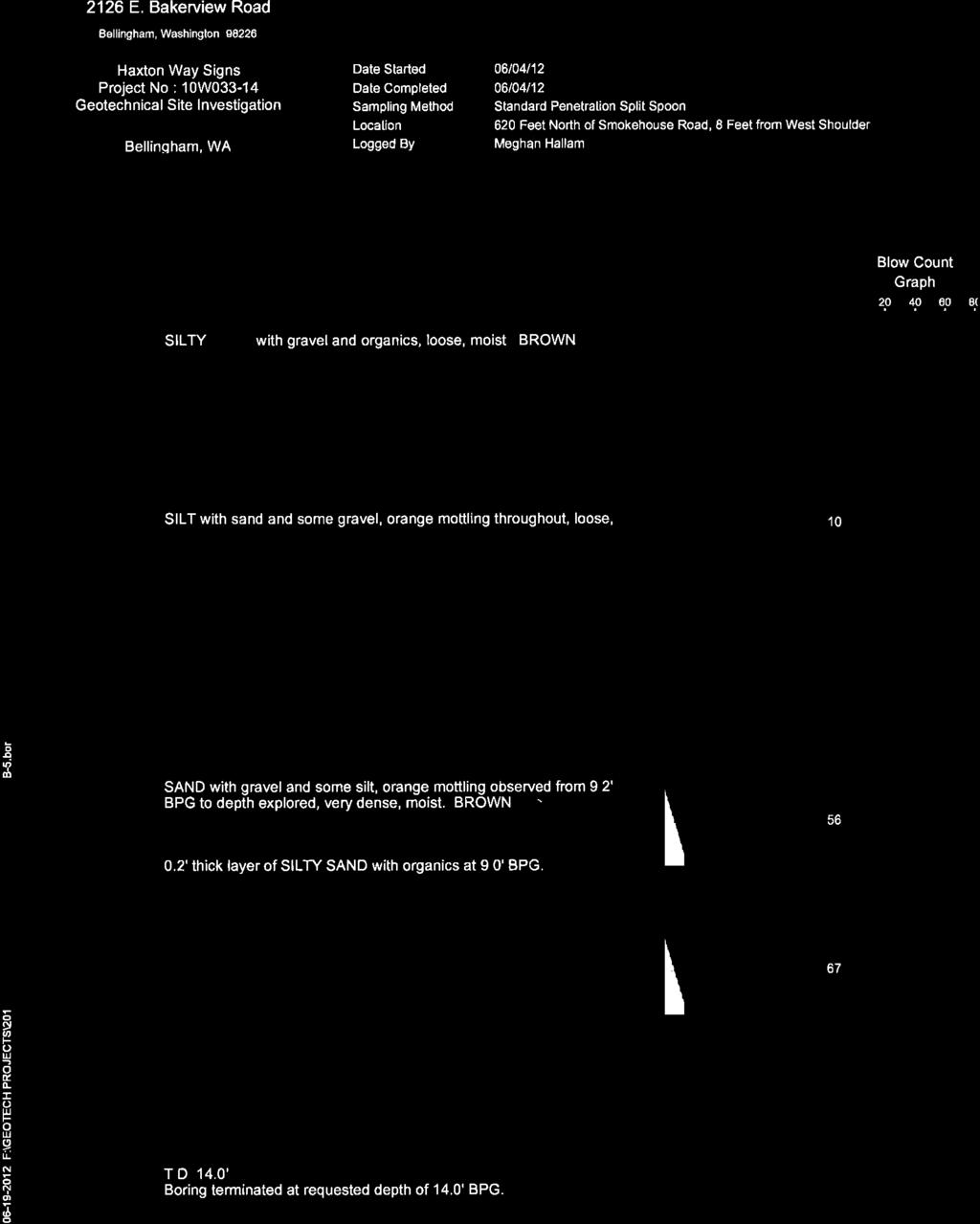
3 In general, between Balch Road (north end of the alignment) and the ferry terminal, the existing grade along the alignment generally slopes down from north to south. It appears that this portion of the roadway was constructed by cut along the east side of the roadway, and fill on the west side of the roadway. The site grade becomes relatively flat between the Emma Road and Mackenzie Road (south end of the alignment). The land use along the project alignment is mostly single-family residences on both sides of the roadway except at the ferry terminal where the terminal occupying the west side of the roadway and a parking lot occupying the east side of the roadway. We understand that sidewalks are to be constructed along the project alignment. The locations, widths and types of sidewalk are yet to be determined at this time. The current phase of the project is to evaluate various alternatives, including a boardwalk, a pervious HMA walkway with curb, an impervious sidewalk with standard curb and gutter, a pervious sidewalk with standard curb and gutter, a separate pedestrian trail, and a combination of the above. SITE GEOLOGY AND SUBSURFACE CONDIITONS The subsurface conditions at the project site are inferred from a review of available geologic data and soil conditions in the project vicinity, and our observations of surficial soil along the alignment. Our review included the Geologic Map of the Bellingham 1:100,000 Quadrangle, Washington (Lapen, 2000), and a summary boring log completed by Material Testing and Consulting, Inc., which is located about 620 feet north Smokehouse Road and 8 feet west from the shoulder of Haxton Way. The geologic map of the project area is shown in Figure 3. The summary boring log is included in Appendix A at the end of this report. According to Lapen (2000), the surficial geologic units mapped at the project site is Glaciomarine Drift, Everson Interstade deposits (Map Unit Qgdm e ). Glaciomarine Drift deposits (Qgdm e ) are described by Lapen as typically moderately to poorly indurated, moderately to unsorted diamicton with lenses and discontinuous beds of moderately to well-sorted gravel, sand, silt, and clay. In summary, based on our review of the geologic map and previous boring, and our observations of surface soils at several location along the alignment, the near-surface subsurface conditions along the Haxton Way between Balch Road and Emma Road is anticipated to consist of medium dense to dense silty sand and medium stiff to stiff silt below the topsoil. The near-surface Gooseberry Pedestrian Improvment Rpt 3 PanGEO, Inc.
4 subsurface conditions along the alignment between Emma Road to Mackenzie Road is anticipated to consist of loose to medium dense, sand and gravel with silt. Groundwater is not anticipated to be present within upper 10 feet of the ground surface in the higher elevation areas between Balch Road and approximately Emma Road. However, perched groundwater seepage may be present in localized areas on the upper slope (east) side of the roadway in the wet seasons. Groundwater level in the flat areas between Emma Road and Mackenzie Road will likely fluctuate with the tide levels in the Lummi Bay. It should be noted that groundwater elevations and seepage rates are likely to vary depending on the season, local subsurface conditions, and other factors. Groundwater levels and seepage rates are normally highest during the winter and early spring. GEOTECHNICAL CONSIDERATIONS SIDEWALK SUBGRADE SUPPORT Based on the anticipated subsurface conditions along the project alignment, it is our opinion that the native soil along the project alignment will provide adequate support for the concrete sidewalks, asphalt sidewalks, or footings for boardwalk, provided the topsoil or surficial unsuitable soils are removed. In our opinion, a leveling course consists of at least 4 inches of crushed surfacing top course, compacted to a dense condition, will need to be placed directly below the concrete or asphalt sidewalks to provide a level and firm uniform support for the section between Balch Road and Emma Road. The leveling course may need to be increased to 8 inches for the section between Emma Road and Mackenzie Road to provide a stable support for the sidewalks. Some loose fill may be present along the west side of the roadway. As a result, some overexcavation and re-compaction of existing soils may be needed in order to provide a firm subgrade for supporting the proposed sidewalk. INFILTRATION CHARACTERISTICS OF ON-SITE SOILS In our opinion, the Glaciomarine Drift deposits along the alignment between Balch Road and approximately Emma Road have limited infiltration capability and significant infiltration of surface water is likely not feasible. The relatively clean sand and gravel soil anticipated between Emma Road and Mackenzie Road is considered to have moderate infiltration capability, and we Gooseberry Pedestrian Improvment Rpt 4 PanGEO, Inc.
5 believe that infiltration of surface water is feasible. We recommend that field explorations be conducted during the design stage of the project to evaluate and characterize the infiltration rates of the site soils along the alignment. PERMANENT CUT SLOPE If a sidewalk will be constructed on the east (upslope) side of the roadway and at approximately the same elevation as the roadway, an excavation in to the hill side will be needed. Based on our field observations, the slope on the east side of the roadway is very gentle, probably less than 15 to 20 percent. Assuming the cut extends about 10 feet into the toe of the slope, the excavation depth is likely on the order of 2-foot deep. If space if available, a permanent 2H:1V slope cut is considered appropriate from the geotechnical engineering perspective. If space is not available, a retaining wall will be needed to retain the cut. RETAINING WALLS Short retaining walls may be needed to facilitate the construction of the proposed sidewalk for the following scenarios: (1) a wall to retain fill on the west side (downslope side) of the roadway for an at-grade sidewalk along the west side of the roadway; (2) a wall to retain cut on the east side (upslope side) of the roadway for an at-grade sidewalk along the east side of the roadway; and (3) a wall to retain fill on the east side (upslope side) of the roadway for an elevated sidewalk along the east side of the roadway. Conventional wall types such as cast-in-place concrete walls and gravity walls (e.g. Ultra Blocks, gabion baskets, or equivalent) are considered appropriate for the envisaged cuts and fills. From the engineering perspective, construction of walls for the above three scenarios are feasible. However, wall construction on the downslope side of the roadway is likely more challenging than on the upslope side of the roadway because of (1) potential presence of loose fill on the downslope side of the roadway, and (2) taller walls on the downslope slope side of the roadway due to steeper slope. Taller walls will also make it more difficult to accommodate the existing driveways that would cross path with the sidewalk. TRAIL ALONG UPSLOPE SIDE OF ROADWAY We understand that a separate pedestrian trial option is also being considered along the upslope side of the roadway. The trail will be located approximately 10 feet from the roadway shoulder Gooseberry Pedestrian Improvment Rpt 5 PanGEO, Inc.
6 In our opinion, the trail is feasible from a geotechnical standpoint. The trail may be constructed with balanced cut and fill method. However, short retaining walls may be needed at localized areas if space is not available for sloped cuts and fills on the both sides of the trail. BOARDWALK An elevated boardwalk is also being considered as an option. A boardwalk is feasible from a geotechnical engineering standpoint. However, it should be noted that it may be very challenging and difficult to accommodate the existing and future driveways that would cross the boardwalk, and may even be cost-prohibitive. In our opinion, the boardwalk may be supported on shallow foundations. Foundation cost may likely be higher for the boardwalk constructed on the downslope side of the roadway than on the upper slope side of the roadway, due to potential presence of fill on the west side of the roadway. Foundation soil over-excavation and backfilling with structural fill may be needed for the boardwalk located in the flat areas in the vicinity of the ferry terminal. In addition, if an elevated boardwalk is planned between the roadway and shoreline, east of the terminal, a deep foundation system, such as driven pin piles, may be needed to support the boardwalk. GENERAL EARTHWORK Earthwork for the proposed pedestrian improvements will include removing surface vegetation, excavating to the design grade, and preparing subgrade. For planning purposes, temporary excavations may be sloped 1H:1V or flatter. Structural fill will likely be needed for the project. Structural fill should consist of WSDOT Gravel Borrow (WSDOT (1)) or approved equivalent. The leveling course material should consist of WSDOT CSBC (crushed surfacing base course, WSDOT (3)). The Gravel Borrow and CSBC should be compacted to at least 95 percent maximum density, determined using ASTM D 1557 (Modified Proctor). CLOSURE We trust that this letter meets your needs at this time. Should you have any questions regarding this letter, please call (206) Gooseberry Pedestrian Improvment Rpt 6 PanGEO, Inc.
7 Sincerely, DRAFT DRAFT H. Michael Xue, P.E. Siew L. Tan, P.E. Senior Geotechnical Engineer Principal Geotechnical Engineer Attachment: Figure 1 Vicinity Map Figure 2 Site and Alignment Map Figure 3 Geology Map Appendix A - Previous Summary Boring Log Gooseberry Pedestrian Improvment Rpt 7 PanGEO, Inc.
8 REFERENCES Lapen, Thomas J., Geologic Map of the Bellingham 1:100,000 Quadrangle, Washington, Washington State Department of Natural Resources. Material Testing and Consulting, 2012, Summary Log of Boring B-5, Haxton Way Signs project (provided by Whatcom County Public Works Department). WSDOT, Standard Specifications for Road, Bridges, and Municipal Construction Gooseberry Pedestrian Improvment Rpt 8 PanGEO, Inc.
 TEA2 N Approximate Alignment Ferry Terminal Gooseberry Point Pedestrian")
9 VicinityL.grf w/ [file.jpg] 8/3/12 (11:06) TEA2 N Approximate Alignment Ferry Terminal Gooseberry Point Pedestrian Improvements Whatcom County, WA Project No. VICINITY MAP Figure No

10 Gooseberry Point Pedestrian Improvements Whatcom County, WA SITE ALIGNMENT MAP Project No. Figure No file.grf w/ file.dat 8/21/12 (14:48) TEA2 Smokehouse Road Southgate Road Emma Road Ferry Terminal
 TEA2 N General Project")

11 VicinityL.grf w/ [file.jpg] 8/17/12(15:32) TEA2 N General Project Vicinity Gooseberry Point Pedestrian Improvements Whatcom County, WA Project No. GEOLOGY MAP Figure No
12 APPENDIX A PREVIOUS SUMMARY BORING LOG
13
How & Where does infiltration work? Summary of Geologic History Constraints/benefits for different geologic units
 June 26, 2007: Low Impact Development 1 Associated Earth Sciences, Inc. Associated Earth Sciences, Inc. Presented by: Matthew A. Miller, PE April 24, 2012 How & Where does infiltration work? Summary of
Civil Engineering, Surveying and Environmental Consulting WASP0059.ltr.JLS.Mich Ave Bridge Geotech.docx
 2365 Haggerty Road South * Canton, Michigan 48188 P: 734-397-3100 * F: 734-397-3131 * www.manniksmithgroup.com August 29, 2012 Mr. Richard Kent Washtenaw County Parks and Recreation Commission 2330 Platt
August 10, 2007 File:
 August 10, 2007 File: 15-85-72 Alberta Infrastructure and Transportation Room 301, Provincial Building 9621-96 Avenue Peace River, AB T8S 1T4 Attention: Mr. Ed Szmata PEACE REGION (PEACE HIGH LEVEL AREA)
patersongroup Consulting Engineers April 20, 2010 File: PG1887-LET.01R Novatech Engineering Consultants Suite 200, 240 Michael Cowpland Drive
 patersongroup April 20, 2010 File: PG1887-LET.01R Novatech Engineering Consultants Suite 200, 240 Michael Cowpland Drive Ottawa, Ontario K2M 1P6 Attention: Mr. Adam Thompson Consulting Engineers 28 Concourse
Date: April 2, 2014 Project No.: Prepared For: Mr. Adam Kates CLASSIC COMMUNITIES 1068 E. Meadow Circle Palo Alto, California 94303
 City of Newark - 36120 Ruschin Drive Project Draft Initial Study/Mitigated Negative Declaration Appendix C: Geologic Information FirstCarbon Solutions H:\Client (PN-JN)\4554\45540001\ISMND\45540001 36120
IV. ENVIRONMENTAL IMPACT ANALYSIS G. GEOLOGY AND SOILS
 IV. ENVIRONMENTAL IMPACT ANALYSIS G. GEOLOGY AND SOILS The following section is a summary of the geotechnical report conducted for the proposed project. The Report of Geotechnical Investigation Proposed
ATTACHMENT A PRELIMINARY GEOTECHNICAL SUMMARY
 ATTACHMENT A PRELIMINARY GEOTECHNICAL SUMMARY Kevin M. Martin, P.E. KMM Geotechnical Consultants, LLC 7 Marshall Road Hampstead, NH 0384 603-489-6 (p)/ 603-489-8 (f)/78-78-4084(m) kevinmartinpe@aol.com
Northern Colorado Geotech
 PRELIMINARY GEOTECHNICAL ENGINEERING REPORT PROPOSED CECIL FARMS DEVELOPMENT WELD COUNTY ROAD 7, BETWEEN ROADS 7 AND 7 SEVERANCE, COLORADO NORTHERN COLORADO GEOTECH PROJECT NO. 0-6 APRIL 0, 06 Prepared
DATA REPORT GEOTECHNICAL INVESTIGATION GALVESTON CRUISE TERMINAL 2 GALVESTON, TEXAS
 DATA REPORT GEOTECHNICAL INVESTIGATION GALVESTON CRUISE TERMINAL 2 GALVESTON, TEXAS SUBMITTED TO PORT OF GALVESTON 123 ROSENBERG AVENUE, 8TH FLOOR GALVESTON, TEXAS 77553 BY HVJ ASSOCIATES, INC. HOUSTON,
REPORT OF PRELIMINARY GEOTECHNICAL EXPLORATION
 REPORT OF PRELIMINARY GEOTECHNICAL EXPLORATION ENKA INTERMEDIATE SCHOOL Sand Hill Road Candler, North Carolina Prepared For: BUNCOMBE COUNTY SCHOOLS Prepared By: AMEC ENVIRONMENT & INFRASTRUCTURE, INC.
1 PROJECT BACKGROUND. August 14, Alberta Transportation Central Region #401, Street Red Deer, Alberta T4N 6K8
 August 14, 2013 Alberta Transportation Central Region #401, 4902 51 Street Red Deer, Alberta T4N 6K8 Mr. Dennis Grace, P.Eng. Construction Engineer Dear Mr. Grace: Central Region Geohazard Assessment 2013
Should you have any questions regarding this clarification, please contact the undersigned at or (925)
") October 8, 2015 Revised October 13, 2015 Contra Costa Community College District 500 Court Street Martinez, CA 94553 Attention: Ron Johnson Subject: Clarification of Grading Requirements Diablo Valley
October 8, 2015 Revised October 13, 2015 Contra Costa Community College District 500 Court Street Martinez, CA 94553 Attention: Ron Johnson Subject: Clarification of Grading Requirements Diablo Valley
M E M O R A N D U M. Mr. Jonathan K. Thrasher, P.E., Mr. Ian Kinnear, P.E. (FL) PSI
 PSI") M E M O R A N D U M TO: FROM: Mr. Mark Schilling Gulf Interstate Engineering Mr. Jonathan K. Thrasher, P.E., Mr. Ian Kinnear, P.E. (FL) PSI DATE: November 11, 2014 RE: Summary of Findings Geotechnical
M E M O R A N D U M TO: FROM: Mr. Mark Schilling Gulf Interstate Engineering Mr. Jonathan K. Thrasher, P.E., Mr. Ian Kinnear, P.E. (FL) PSI DATE: November 11, 2014 RE: Summary of Findings Geotechnical
SUMMARY OF SOIL CONDITIONS CITYWIDE SIDEWALK IMPROVEMENT PROJECT JIMMY DURANTE BOULEVARD, VIA DE LA VALLE, AND CAMINO DEL MAR DEL MAR, CALIFORNIA
 SUMMARY OF SOIL CONDITIONS CITYWIDE SIDEWALK IMPROVEMENT PROJECT JIMMY DURANTE BOULEVARD, VIA DE LA VALLE, AND CAMINO DEL MAR DEL MAR, CALIFORNIA PREPARED FOR NASLAND ENGINEERING SAN DIEGO, CALIFORNIA
Re: Steep Slope Assessment for 2465 Waverly Drive, Blind Bay, BC; Legal Address: Lot 39, Section 18, Township 22, Range 10, Plan 25579, W6M, KDYD.
 OEL File 1563-1 May 30, 2017 Doug Wall PO Box 774 Salmon Arm, BC V1E 4N7 Re: Steep Slope Assessment for 2465 Waverly Drive, Blind Bay, BC; Legal Address: Lot 39, Section 18, Township 22, Range 10, Plan
Depth (ft) USCS Soil Description TOPSOIL & FOREST DUFF
 USCS Soil Description TOPSOIL & FOREST DUFF") Test Pit No. TP-6 Location: Latitude 47.543003, Longitude -121.980441 Approximate Ground Surface Elevation: 1,132 feet Depth (ft) USCS Soil Description 0 1.5 1.5 5.0 SM 5.0 8.0 SM Loose to medium dense,
Test Pit No. TP-6 Location: Latitude 47.543003, Longitude -121.980441 Approximate Ground Surface Elevation: 1,132 feet Depth (ft) USCS Soil Description 0 1.5 1.5 5.0 SM 5.0 8.0 SM Loose to medium dense,
Converse Consultants Geotechnical Engineering, Environmental & Groundwater Science, Inspection & Testing Services
 Converse Consultants Geotechnical Engineering, Environmental & Groundwater Science, Inspection & Testing Services Ms. Rebecca Mitchell Mt. San Antonio College Facilities Planning & Management 1100 North
Slope Stability Evaluation Ground Anchor Construction Area White Point Landslide San Pedro District Los Angeles, California.
 Slope Stability Evaluation Ground Anchor Construction Area White Point Landslide San Pedro District Los Angeles, California Submitted To: Mr. Gene Edwards City of Los Angeles Department of Public Works
GEOLOGY, SOILS, AND SEISMICITY
 4.9 GEOLOGY, SOILS, AND SEISMICITY 4.9.1 Introduction Information about the geological conditions and seismic hazards in the study area was summarized in the FEIR, and was based on the Geotechnical Exploration
1. PROJECT BACKGROUND. July 18, Alberta Infrastructure & Transportation Central Region #401, Street Red Deer, Alberta T4N 6K8
 July 18, 2005 Alberta Infrastructure & Transportation Central Region #401, 4902 51 Street Red Deer, Alberta T4N 6K8 Mr. Alain Momedi, P.Eng. Project Engineer Dear Mr. Momedi: H11:04 km 11.1 Erosion along
3.12 Geology and Topography Affected Environment
 3 Affected Environment and Environmental Consequences 3.12 Geology and Topography 3.12.1 Affected Environment 3.12.1.1 Earthquakes Sterling Highway MP 45 60 Project Draft SEIS The Kenai Peninsula is predisposed
CITY OF PUYALLUP TOSCANOS SINKHOLE EVALUATION
 CITY OF PUYALLUP PIERCE COUNTY WASHINGTON TOSCANOS SINKHOLE EVALUATION G&O #15470 OCTOBER 2015 TABLE OF CONTENTS BACKGROUND...1 EXISTING SYSTEM...1 Stormwater Conveyance System...1 Video Inspection...2
 R-1 Conveyor Relocation Project Legend 0 500 1000 1500 ft. This map is a user generated static output from an Internet mapping site and is for general reference only. Data layers that appear on this map
Appendix F4.11 Geologic Unit Summaries, Hazard Areas, and Boring Locations
 Appendix F4.11 Geologic Unit Summaries, Hazard Areas, and Boring Locations Appendix F4.11 Geologic Unit Summaries and Hazard Areas TABLE F4.11-1 Summary of Geologic Units and their Engineering Properties
Ardaman & Associates, Inc. Geotechnical, Environmental and Materials Consultants
 SUBSURFACE SOIL EXPLORATION 42-INCH FORCE MAIN REPLACEMENT CHIQUITA BOULEVARD S AND SW 34 TH STREET CAPE CORAL, LEE COUNTY, FLORIDA Ardaman & Associates, Inc. Geotechnical, Environmental and Materials
MEMORANDUM. wa.tsr..-z.n~.e.s-t.i~at.i.o.ns... Branch... Mr. Webster contends that prior to excavation of the gravel
 TO... J. C. Foweraker 2... Head Gr o w a t er S e c t i on... Hyar....og~~~.~.~vis.ion... wa.tsr..-z.n~.e.s-t.i~at.i.o.ns... Branch... eernment OF BRITISH COLUMBIA MEMORANDUM II 0 PROM A. P. Kohut, Geological
June 9, R. D. Cook, P.Eng. Soils Engineer Special Services Western Region PUBLIC WORKS CANADA WESTERN REGION REPORT ON
 PUBLIC WORKS CANADA WESTERN REGION REPORT ON GEOTECHNICAL INVESTIGATION PROPOSED MARTIN RIVER BRIDGE MILE 306.7 MACKENZIE HIGHWAY Submitted by : R. D. Cook, P.Eng. Soils Engineer Special Services Western
Geotechnical Engineering Study, Conifer Senior High School Football Field Improvements, Conifer, Colorado
 2390 South Lipan Street Denver, CO 80223 phone: (303) 742-9700 fax: (303) 742-9666 email: kadenver@kumarusa.com www.kumarusa.com Office Locations: Denver (HQ), Colorado Springs, Fort Collins, and Frisco,
Roy Pyle March 24, 2017 Chief Facilities Planner Contra Costa Community College District 500 North Court Street Martinez, CA 94533
 State of California Natural Resources Agency Edmund G. Brown Jr., Governor Department of Conservation John G. Parrish, Ph.D., State Geologist California Geological Survey 801 K Street MS 12-31 Sacramento,
Geotechnical Engineering Subsurface Exploration The Proposed LAPLAWD Phase 2B 12 Main Water Line Durango, Colorado
 July, La Plata Archuleta Water District c/o Harris Water Engeerg, P.E. East nd Avenue, Suite Durango, Colorado brett@durangowater.com PN: GE Subject: Geotechnical Engeerg Subsurface Exploration The Proposed
Geotechnical Investigation Juneau Seawalk - Taku Fisheries to Miner s Wharf Juneau, Alaska DM&A Job No
 Duane Miller & Associates 5821 Arctic Boulevard, Suite A Anchorage, AK 99518-1654 (907) 644-3200 Fax 644-0507 Arctic & Geotechnical Engineering May 4, 2006 Tetra Tech/KCM, Inc. 1971 First Avenue Seattle,
patersongroup Mineral Aggregate Assessment 3119 Carp Road Ottawa, Ontario Prepared For Mr. Greg LeBlanc March 7, 2014 Report: PH2223-REP.
 Geotechnical Engineering Environmental Engineering group Hydrogeology Geological Engineering Archaeological Studies Materials Testing 3119 Carp Road Prepared For Mr. Greg LeBlanc March 7, 2014 Paterson
Impact : Changes to Existing Topography (Less than Significant)
") 4.2 Land Resources 4.2.1 Alternative A Proposed Action Impact 4.2.1-1: Changes to Existing Topography (Less than Significant) Development of the project site would involve grading and other earthwork as
4.2 Land Resources 4.2.1 Alternative A Proposed Action Impact 4.2.1-1: Changes to Existing Topography (Less than Significant) Development of the project site would involve grading and other earthwork as
GEOTECHNICAL INVESTIGATION MULTIPLE STREETS AND ROADS F18-INF CITY OF CLARENCE-ROCKLAND
 GEOTECHNICAL INVESTIGATION MULTIPLE STREETS AND ROADS F18-INF-2018-012 CITY OF CLARENCE-ROCKLAND Prepared for: The City of Clarence-Rockland Attn: Mr. Alain Beaulieu, Coordinator, Capital Projects 1560
CITY OF CAPE CORAL NORTH 2 UTILITIES EXTENSION PROJECT CONTRACT 3
 GEOTECHNICAL REPORT CITY OF CAPE CORAL NORTH UTILITIES EXTENSION PROJECT CONTRACT City of Cape Coral Procurement Division Cultural Park Boulevard, nd Floor Cape Coral, FL ISSUED FOR BID VOLUME of GEOTECHNICAL
THE MINISTRY OF ENERGY AND ENERGY INDUSTRIES MINERALS DIVISION MINE DESIGN TEMPLATE OPERATOR NAME: OPERATOR ADDRESS: PHONE NUMBER: FACSIMILE:
 THE MINISTRY OF ENERGY AND ENERGY INDUSTRIES MINERALS DIVISION MINE DESIGN TEMPLATE 1.0 GENERAL INFORMATION OPERATOR NAME: OPERATOR ADDRESS: PHONE NUMBER: FACSIMILE: NAME OF CONTACT: CELLULAR PHONE: EMAIL
Appendix M Preliminary Geotechnical Report, SR 32 Widening Project Study Report
 Appendix M Preliminary Geotechnical Report, SR 32 Widening Project Study Report November 3, 2005 Mr. Chris Rockway 7300 Folsom Boulevard, Suite 203 Sacramento, California 95826 Attention: Matt Brogan
SUPPLEMENTARY INVESTIGATION AND LABORATORY TESTING Aggregate Resource Evaluation Proposed Bernand Quarry San Diego County, California
 October 3, 2 Mr. Mark San Agustin Project No. 28-- Home Land Investments Document No. -92 2239 Curlew Street San Diego, CA 92 SUBJECT: SUPPLEMENTARY INVESTIGATION AND LABORATORY TESTING Aggregate Resource
NAPLES MUNICIPAL AIRPORT
 NAPLES MUNICIPAL AIRPORT NAPLES MUNICIPAL AIRPORT (APF) TAXIWAY D REALIGNMENT AND DRAINAGE IMPROVEMENTS NORTH QUADRANT ADDENDUM NUMBER TWO March, The following Addendum is hereby made a part of the Plans
February 22, 2016 AG File No
 Ainley Graham & Associates Limited 1-50 Grant Timmins Drive, Kingston, Ontario, K7M 8N2 Tel: (343) 266-0002 Fax: (343) 266-0028 E-mail Kingston@ainleygroup.com February 22, 2016 AG File No. 15062-1 Ministry
PREPARED FOR MR. JOE WOOD CARTER & SLOOPE, INC PEAKE ROAD MACON, GEORGIA PREPARED BY
 SUBSURFACE EXPLORATION AND GEOTECHNICAL ENGINEERING EVALUATION MACON WATER AUTHORITY (MWA) SANITARY SEWER RELOCATION MACON, GEORGIA GEC PROJECT NO. 14077.2 PREPARED FOR MR. JOE WOOD CARTER & SLOOPE, INC.
Hydrogeological Assessment for Part of Lots 2 and 3, Concession 5, Township of Thurlow, County of Hastings 1.0 INTRODUCTION. 1.
 February 10,2017 25506400 Ontario Ltd. Foxboro, ON Attention: Brad Newbatt Re: Hydrogeological Assessment for Part of Lots 2 and 3, Concession 5, Township of Thurlow, County of Hastings 1.0 INTRODUCTION
 Photo 1 - Southerly view across 2700 parking lot toward existing building. Multi-residential building borders western side of property in upper right of view. Photo 2 - Southerly view across 2750 parking
APPENDICES. Appendix A City Standard Details Appendix B Engineering Geology Report
 APPENDICES Appendix A City Standard Details Appendix B Engineering Geology Report APPENDIX A CITY STANDARDS DETAILS APPENDIX B ENGINEERING GEOLOGY REPORT ENGINEERING GEOLOGY REPORT WATER
The results of KCB s site inspection observations and our recommendations for further work are presented herein.
 July 14, 2015 Central Region 401, 4902 51 Street Red Deer, Alberta T4N 6K8 Mr. Tony Penney, P.Eng. Construction Engineer Dear Mr. Penney: June 25, 2015 Site Inspection Report The above site was visited
Pierce County Department of Planning and Land Services Development Engineering Section
 Page 1 of 7 Pierce County Department of Planning and Land Services Development Engineering Section PROJECT NAME: DATE: APPLICATION NO.: PCDE NO.: LANDSLIDE HAZARD AREA (LHA) GEOLOGICAL ASSESSMENT REPORT
Field Exploration. March 31, J-U-B ENGINEERS, Inc. 115 Northstar Avenue Twin Falls, Idaho Attn: Mr. Tracy Ahrens, P. E. E:
 March 31, 201 11 Northstar Avenue 83301 Attn: Mr. Tracy Ahrens, P. E. E: taa@jub.com Re: Geotechnical Data Report Preliminary Phase 1 Field Exploration Revision No. 1 Proposed Rapid Infiltration Basin
December 11, 2006 File:
 December 11, 2006 File: 15-85-38 Alberta Infrastructure and Transportation Room 301, Provincial Building 9621-96 Avenue Peace River, Alberta T8S 1T4 Attention: Mr. Ed Szmata PEACE REGION (SWAN HILLS AREA)
DRAFT. Geotechnical Engineering Services. Army Street Project Bellingham, Washington. for Bellingham Public Development Authority.
 Geotechnical Engineering Services Army Street Project Bellingham, Washington for Bellingham Public Development Authority May 16, 2014 600 Dupont Street Bellingham, Washington 98225 360.647.1510 Geotechnical
Geotechnical Data Report
 Geotechnical Data Report Downtown Greenville Future Conveyance Study December 1, 2015 Terracon Project No. 86155032 Prepared for: Prepared by: Terracon Consultants, Inc. December 1, 2015 561 Mauldin Road
October 26, Ms. Aimee Zack Canadian Pacific 120 S. Sixth Street Suite 900 Minneapolis, Minnesota 55402
 October 26, 2017 Ms. Aimee Zack Canadian Pacific 120 S. Sixth Street Suite 900 Minneapolis, Minnesota 55402 Re: Soo Line Dump Site 2017 Annual Soil Cover Inspection Dear Aimee: The purpose of this letter
This report was prepared by Klohn Crippen Consultants Ltd. for Alberta Transportation Central Region under Contract No. CE053/2000.
 Alberta Transportation Central Region #401, 4902 51 Street Red Deer, Alberta T4N 6K8 June 7, 2002 Mr. Melvin Mayfield, P.Eng. Project Engineer Dear Mr. Mayfield: Central Region Landslide Assessment Site
IMAGING OF DEEP SINKHOLES USING THE MULTI-ELECTRODE RESISTIVITY IMPLANT TECHNIQUE (MERIT) CASE STUDIES IN FLORIDA
 CASE STUDIES IN FLORIDA") IMAGING OF DEEP SINKHOLES USING THE MULTI-ELECTRODE RESISTIVITY IMPLANT TECHNIQUE (MERIT) CASE STUDIES IN FLORIDA David Harro The G3 Group, 2509 Success Drive, Suite 1, Odessa, FL 33556, david.harro@geo3group.com
IMAGING OF DEEP SINKHOLES USING THE MULTI-ELECTRODE RESISTIVITY IMPLANT TECHNIQUE (MERIT) CASE STUDIES IN FLORIDA David Harro The G3 Group, 2509 Success Drive, Suite 1, Odessa, FL 33556, david.harro@geo3group.com
Prepared for: Sports and Exhibition Authority of Pittsburgh and Allegheny County
 December 2012 PRE-FINAL GEOTECHNICAL ENGINEERING REPORT S.O. 127410 LOWER HILL REDEVELOPMENT PROJECT PITTSBURGH, ALLEGHENY COUNTY, PENNSYLVANIA Prepared for: Sports and Exhibition Authority of Pittsburgh
PHIMF Project - Limited Geotechnical Investigation - Feasibility-Level Report RESPONSE TO INITIAL REVIEW LETTER
 Connie Christian, P.E. County Sanitation Districts of Los Angeles County 1955 Workman Mill Road Whittier, California 90601 Project No. BAS 04-02E January 29, 2008 Subject: PHIMF Project - Limited Geotechnical
January 16, Re: Soo Line Dump Site 2018 Annual Soil Cover Inspection. Dear Mr. Nichols:
 January 16, 2019 Mr. Andrew Nichols Minnesota Pollution Control Agency Voluntary Investigation and Cleanup Program 520 Lafayette Road Saint Paul, Minnesota 55155 Re: Soo Line Dump Site 2018 Annual Soil
B-1 BORE LOCATION PLAN. EXHIBIT Drawn By: 115G BROOKS VETERINARY CLINIC CITY BASE LANDING AND GOLIAD ROAD SAN ANTONIO, TEXAS.
 N B-1 SYMBOLS: Exploratory Boring Location Project Mngr: BORE LOCATION PLAN Project No. GK EXHIBIT Drawn By: 115G1063.02 GK Scale: Checked By: 1045 Central Parkway North, Suite 103 San Antonio, Texas 78232
ENGINEERING EVALUATION OF THE STANLEY MINE ADVENTURE PARK AREA CLEAR CREEK COUNTY, COLORADO. Prepared for:
 braun Braun Consulting Engineers ENGINEERING EVALUATION OF THE STANLEY MINE ADVENTURE PARK AREA CLEAR CREEK COUNTY, COLORADO Prepared for: STANLEY MINES ADENTURE PARK 3375 W. POWERS CIRCLE LITTLETON, COLORADO
APPENDIX H SOIL SURVEY
 Environmental Impact Statement Beryl Solar Farm APPENDIX H SOIL SURVEY Beryl Solar Farm 16 347 Final V1 H i Geotechnical Engineers & Engineering Geologists NATA Accredited Laboratories for Asphalt, Aggregate,
2. Initial Summary of Preliminary Expert Opinion of Converse and Psomas Reports
 UNITED WALNUT TAXPAYERS PRELIMINARY REVIEW OF NEGATIVE GEOTECHNICAL AND GEOLOGICAL ASPECTS OF CONSTRUCTING EARTHFILL PAD FOR A SOLAR FARM ON THE WEST PARCEL - DRAFT 1. Introduction A licensed Engineering
Redwood City Harbor, California, Navigation Improvement Feasibility Study. Appendix D. Geotechnical Engineering. DRAFT April 2015
 1 Redwood City Harbor, California, Navigation Improvement Feasibility Study Appendix D Geotechnical Engineering DRAFT April 2015 2 Contents 1 Purposes of Report... 3 2 Background... 3 3 References and
Report of Preliminary Geotechnical Exploration. CSO-012 Sewer Separation Cincinnati, Hamilton County, Ohio. February, 2011
 11242843_GeoTech_Preliminary - Feburary 2011_1/40 Report of Preliminary Geotechnical Exploration CSO-012 Sewer Separation Cincinnati, Hamilton County, Ohio February, 2011 11242843_GeoTech_Preliminary -
R.M.HARW & ASSOCIATES LTD. GEOTECHNICAL INVESTIGATION PROPOSED BRIDGE SITE. HELAVA CREEKl MILE MACKENZIE HIGHWAY E-2510 OCTOBER 16, 1973
 El R.M.HARW & ASSOCIATES LTD. GEOTECHNICAL INVESTIGATION PROPOSED BRIDGE SITE HELAVA CREEKl MILE 616.4 MACKENZIE HIGHWAY E-2510 OCTOBER 16, 1973 R,M,HARDV & ASSOCIATES LTD. CONSULTING ENGINEERING & TESTING
January 12, 2006 File:
 January 12, 2006 File: 15-85-13 Alberta Infrastructure and Transportation Room 301, Provincial Building 9621-96 Avenue Peace River, Alberta T8S 1T4 Attention: Mr. Ed Szmata PEACE REGION (PEACE HIGH LEVEL
RESERVOIR DRAWDOWN RATES/RESERVOIR DRAWDOWN TEST Iron Gate, Copco (I & II), and JC Boyle Dams
, and JC Boyle Dams") TECHNICAL MEMORANDUM No. 1 TO: Michael Bowen California Coastal Conservancy Geotechnical & Earthquake Engineering Consultants CC: Eric Ginney Philip Williams & Associates PREPARED BY: Paul Grant SUBJECT:
TECHNICAL MEMORANDUM No. 1 TO: Michael Bowen California Coastal Conservancy Geotechnical & Earthquake Engineering Consultants CC: Eric Ginney Philip Williams & Associates PREPARED BY: Paul Grant SUBJECT:
APPENDIX E SOILS TEST REPORTS
 Otsego County, NY Site Work Specifications APPENDIX E SOILS TEST REPORTS Blue Wing Services, Inc. July 1, 2010 Blue Wing Services May 20, 2010 Page 2 the site, was not made available to Empire at this
January 17, 2008 File:
 January 17, 2008 File: 15-85-73 Alberta Infrastructure and Transportation Room 301, Provincial Building 9621-96 Avenue Peace River, Alberta T8S 1T4 Attention: Mr. Ed Szmata PEACE REGION (SWAN HILLS AREA)
10 May Rod Walls - Director Facilities New Construction, Sustainability Hays CISD IH 35 Kyle, Texas 78640
 10 May 2017 Rod Walls - Director Facilities New Construction, Sustainability Hays CISD 21003 IH 35 Kyle, Texas 78640 Re: Hays CISD Proposed ES15 Site, Buda Phase II Soil Sampling Dear Rod: Concern has
APPENDIX 1. Geotechnical Information and Analysis. Pacific Aggregates Inc. and Pacific Clay Products July 13, 2011 RP112 Reclamation Plan
 Pacific Aggregates Inc. and Pacific Clay Products July 13, 2011 RP112 Reclamation Plan APPENDIX 1 Geotechnical Information and Analysis PA02_RP112-RecPlan-Resub_FNL.docx SESPE Consulting, Inc. June 27,
CENTRAL REGION GEOHAZARDS RISK ASSESSMENT SITE INSPECTION FORM
 SITE NUMBER AND NAME C55 H861:02 Slide LEGAL DESCRIPTION NW 14-40-14-W4 CENTRAL REGION GEOHAZARDS RISK ASSESSMENT SITE INSPECTION FORM HIGHWAY & KM NAD 83 COORDINATES N 5811217 E 437291 PREVIOUS INSPECTION
Geotechnical Engineering Report
 Geotechnical Engineering Report Turner Turnpike Widening Polecat Creek Bridge (Bridge A) June 1, 2016 Terracon Project No. 04155197 Prepared for: Garver, LLC Prepared by: Terracon Consultants, Inc. TABLE
February 18, 2003 File: NORTH CENTRAL REGION LANDSLIDE ASSESSMENT HWY 43:16 WHITECOURT EAST HILL (NC1) 2002 ANNUAL INSPECTION REPORT
 2002 ANNUAL INSPECTION REPORT") February 18, 2003 File: 15-76-11 Alberta Transportation Room 223, Provincial Building 4709 44 Avenue Stony Plain, Alberta T7Z 1N4 Attention: Mr. Rob Lonson, P.Eng. NORTH CENTRAL REGION LANDSLIDE ASSESSMENT
February 18, 2003 File: 15-76-11 Alberta Transportation Room 223, Provincial Building 4709 44 Avenue Stony Plain, Alberta T7Z 1N4 Attention: Mr. Rob Lonson, P.Eng. NORTH CENTRAL REGION LANDSLIDE ASSESSMENT
Converse Consultants Geotechnical Engineering, Environmental & Groundwater Science, Inspection & Testing Services
 Converse Consultants Geotechnical Engineering, Environmental & Groundwater Science, Inspection & Testing Services July 27, 2017 Ms. Rebecca Mitchell Mt. San Antonio College Facilities Planning & Management
Geotechnical Engineering Report
 Geotechnical Engineering Report Turner Turnpike Widening Bridge B Bridge Crossing: South 257 th West Avenue Creek County, Oklahoma June 1, 2016 Terracon Project No. 04155197 Prepared for: Garver, LLC Tulsa,
Prepared for. Mr. Denis A. Verdon 445, Wilson Road Rockland, Ontario K4K 1K7
 GEOTECHNICAL INVESTIGATION Proposed Verdon Subdivision Part of Lot 16, Concession I (Old Survey) Geographic Township of Clarence Now City of Clarence-Rockland Prepared for Mr. Denis A. Verdon 445, Wilson
RAINSONG DEVELOPMENT PHASE I AND II
 SUBSURFACE EXPLORATION, GEOLOGIC HAZARD, AND PRELIMINARY GEOTECHNICAL ENGINEERING REPORT RAINSONG DEVELOPMENT PHASE I AND II Prepared for: IS Property Investments, LLC 419 Occidental Avenue South, Suite
EXHIBIT H LOT 317 GRADING AND SITE PLAN
 EXHIBIT H LOT 317 GRADING AND SITE PLAN EXHIBIT I LOT 317 ELEVATIONS ridge height 4915'-6" GENERAL & KEYED NOTES ridge height 4905'-9" 3 7 4 A5.1 1 5 ridge height 4910'-6" 2 ridge height 4906'-3" 1 Provide
F_._G_. _.E_._,_L_T_D_ ~-11'-~~L ~
 : e 99o'3 (} rr WtR!'~ _;, F G E,_L_T_D_ ~11'~~L ~ Fewell Geotechhicai Engineering, Ltd 3 2825 Koapaka St Honolulu, Hawaii 96819 (88) 8362171 {/~ ' File No 328,1 October 29, 198 Mr Evan Cruthers c/o Media
September 21, 2004 GeoInsight Project
 GeoInsight, Inc. GeoInsight, Inc. GeoInsight, Inc. 75 Gilcreast Road, Suite 210 319 Littleton Road, Suite 105 Corporate Ten Center Londonderry, NH 03053-3566 Westford, MA 01886 1781 Highland Avenue, Suite
Geology and Soils. Geology. Soils [ 251 ]
![Geology and Soils. Geology. Soils [ 251 ]](/thumbs/89/97974301.jpg "Geology and Soils. Geology. Soils [ 251 ]") December 2010 Geology and Soils This section describes the local geology, soils, groundwater, and seismology in the Sunrise Project area. All of these factors affect the constructability of the project
December 2010 Geology and Soils This section describes the local geology, soils, groundwater, and seismology in the Sunrise Project area. All of these factors affect the constructability of the project
16 January 2018 Job Number: RICHARD NEWMAN C\- CLARK FORTUNE MCDONALD AND ASSOCIATES PO BOX 553 QUEENSTOWN
 16 January 2018 Job Number: 50595 RICHARD NEWMAN C\- CLARK FORTUNE MCDONALD AND ASSOCIATES PO BOX 553 QUEENSTOWN CHANSEN@CFMA.CO.NZ STORMWATER DISPOSAL ASSESSMENT Dear Richard, RDAgritech were requested
ENVIRONMENTAL IMPACT ANALYSIS C. GEOLOGY AND SOILS
 IV. ENVIRONMENTAL IMPACT ANALYSIS The following analysis of geology, soils and seismic hazards is based primarily upon the technical report Geotechnical Engineering Investigation Proposed Fashion Square
Engineer. Engineering. Engineering. (in-ja-neer ) A person trained and skilled in any of the various branches of engineering: a civil engineer
 A person trained and skilled in any of the various branches of engineering: a civil engineer") Engineer (in-ja-neer ) A person trained and skilled in any of the various branches of engineering: a civil engineer (Random House Webster s College Dictionary, 1991) CE100 Introduction to Civil Geotechnical
Engineer (in-ja-neer ) A person trained and skilled in any of the various branches of engineering: a civil engineer (Random House Webster s College Dictionary, 1991) CE100 Introduction to Civil Geotechnical
IV. ENVIRONMENTAL IMPACT ANALYSIS E. GEOLOGY/SOILS
 IV. ENVIRONMENTAL IMPACT ANALYSIS E. GEOLOGY/SOILS Except where otherwise noted, the following Section is based on the Preliminary Geotechnical Investigation, Proposed Medical Office Buildings and Mixed-Use
PRELIMINARY GEOTECHNICAL ENGINEERING REPORT
 PRELIMINARY GEOTECHNICAL ENGINEERING REPORT TOWN OF ASHLAND TOWN HALL 101 THOMPSON STREET ASHLAND, VIRGINIA JOB NUMBER: 39016 PREPARED FOR: PMA PLANNERS & ARCHITECTS 10325 WARWICK BOULEVARD NEWPORT NEWS,
Preliminary Geotechnical Investigation Cadiz / Trigg County I-24 Business Park. Cadiz, Kentucky
 Environmental & Geoscience, LLC 834 Madisonville Road Hopkinsville, KY 440 70.44.000 FAX 70.44.8300 www.wedrill.com A member of Trinity Energy & Infrastructure Group, LLC Preliminary Geotechnical Investigation
April 10, Mr. Curt Van De Walle, City Manager City of Castle Hills 209 Lemonwood Drive Castle Hills, Texas 78213
 Mr. Curt Van De Walle, City Manager City of Castle Hills 209 Lemonwood Drive Castle Hills, Texas 78213 Subject: Revised Castle Hills BASIS Charter School Traffic Impact Analysis Review City of Castle Hills,
PRELIMINARY GEOTECHNICAL REPORT. State College Redevelopment State College Borough, Centre County, Pennsylvania. CMT Laboratories File No.
 PRELIMINARY GEOTECHNICAL REPORT State College Redevelopment State College Borough, Centre County, Pennsylvania CMT Laboratories File No. 1638700 Prepared for: National Development Council One Battery Park
GEOTECHNICAL SITE INVESTIGATION REPORT SUBDIVISION - SELECTED LOTS AKISQNUK FIRST NATION WINDERMERE, BC
 GEOTECHNICAL SITE INVESTIGATION REPORT SUBDIVISION - SELECTED LOTS AKISQNUK FIRST NATION WINDERMERE, BC Prepared For: Akisqnuk First Nation Windermere, BC Box 688 Fernie, BC V0B 1M0 250 423 4829 August
PRELIMINARY GEOTECHNICAL ENGINEERING REPORT. Proposed Re-Development 44 Old Worcester Road Charlton, Massachusetts. Prepared For:
 PRELIMINARY GEOTECHNICAL ENGINEERING REPORT Proposed Re-Development 44 Old Worcester Road Charlton, Massachusetts Prepared For: Meridian Associates, Inc. 500 Cummings Center, Suite 5950 Beverly, Massachusetts
Geotechnical Engineering Services
 Geotechnical Engineering Services, Washington for February, 2014 Earth Science + Technology Geotechnical Engineering Services Crystal Mountain Boulevard Upgrade Pierce County, Washington for Pierce County
Downtown Anchorage Seismic Risk Assessment & Land Use Regulations to Mitigate Seismic Risk
 Prepared for: The Municipality of Anchorage Planning Department and the Geotechnical Advisory Commission Downtown Anchorage Seismic Risk Assessment & Land Use Regulations to Mitigate Seismic Risk Prepared
KDOT Geotechnical Manual Edition. Table of Contents
 KDOT Geotechnical Manual 2007 Edition The KDOT Geotechnical Manual is available two volumes. Both volumes are very large electronic (pdf) files which may take several minutes to download. The table of
AN EMPLOYEE OWNED COMPANY
 CTL Engineering, Inc. 2860 Fisher Road, P.O. Box 4448, Columbus, Ohio 43204338 Phone: 614/2768123 Fax: 614/2766377 Email: ctl@ctleng.com AN EMPLOYEE OWNED COMPANY Consulting Engineers Testing Inspection
December 16, Mr. Lee Hughes Southwest Florida Water Management District Tampa Service Office 7601 Highway 301 North Tampa, FL 33637
 December 16, 2015 Mr. Lee Hughes Southwest Florida Water Management District Tampa Service Office 7601 Highway 301 North Tampa, FL 33637 RE: Response to SWFWMD Supplemental Information Request Dear Mr.
Table of Contents. Description
 Table of Contents Description Page A. Introduction... 1 A.1. Project Description... 1 A.2. Site Conditions and History... 2 A.3. Purpose... 3 A.4. Background Information and Reference Documents... 4 A.5.
August 28, 2013 PN: 53225GE. Geotechnical Engineering Subsurface Exploration The Proposed LAPLAWD Phase 1E 12 Main Water Line Durango, Colorado
 August 8, La Plata Archuleta Water District c/o Harris Water Engeerg, P.E. 9 East nd Avenue, Suite Durango, Colorado 8 brett@durangowater.com Subject: Geotechnical Engeerg Subsurface Exploration The Proposed
Advanced Geologic Exploration, Inc.
 Advanced Geologic Exploration, Inc. Scientists of the Earth PO Box 1956, Chester, CA 96020 Voice: (530) 258-4228 Fax (530) 258-4339 www.advancedgeologic.com January 23, 2009 Job No. G-081201 Terri Barber,
Groundwater Investigation SOUTHGATE GRAVEL PIT Part of Lot 15, Concession 15 (formerly Township of Proton), Township of Southgate.
, Township of Southgate.") Groundwater Investigation SOUTHGATE GRAVEL PIT Part of Lot 15, Concession 15 (formerly Township of Proton), Township of Southgate County of Grey October, 2014 Prepared for: Drysdale Aggregate Consulting
Groundwater Investigation SOUTHGATE GRAVEL PIT Part of Lot 15, Concession 15 (formerly Township of Proton), Township of Southgate County of Grey October, 2014 Prepared for: Drysdale Aggregate Consulting
3.18 GEOLOGY AND SOILS
 3.18 GEOLOGY AND SOILS This section discusses geologic resource concerns as they relate to the environment, public safety, and project design both during construction and after completion of the project.