Geotechnical Engineering Study, Conifer Senior High School Football Field Improvements, Conifer, Colorado
|
|
|
- Barnaby Ramsey
- 5 years ago
- Views:
Transcription
, Colorado Springs, Fort Collins, and Frisco, Colorado December 18, 2012 Ms.")
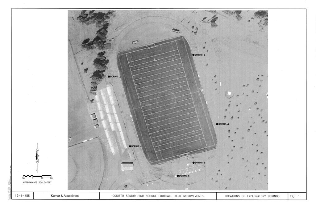
1 2390 South Lipan Street Denver, CO phone: (303) fax: (303) Office Locations: Denver (HQ), Colorado Springs, Fort Collins, and Frisco, Colorado December 18, 2012 Ms. Katie Bartojay Conifer Senior High School Booster Club County Road 73 Conifer, Colorado Subject: Geotechnical Engineering Study, Conifer Senior High School Football Field Improvements, Conifer, Colorado Dear Ms. Bartojay: Project No This letter presents the results of a geotechnical engineering study for the proposed improvements to the football field located at the Conifer Senior High School, County Road 73 in Conifer, Colorado. A subsurface study was conducted for the purpose of developing foundation recommendations associated with the four high-mast light poles and the modular building structures to be constructed at the site. The project site is shown on Fig. 1. The study was conducted in accordance with the scope of work in our Proposal No. P to the Booster Club dated October 11, A field exploration program consisting of exploratory borings was conducted to obtain information on subsurface conditions. Samples of the soils and bedrock obtained during the field exploration were tested in the laboratory to determine their classification and engineering characteristics. The results of the field exploration and laboratory testing were analyzed to develop recommendations for foundation types, depths and allowable pressures for the proposed high-mast lighting and modular building foundations. The results of the field exploration and laboratory testing are presented herein. This report has been prepared to summarize the data obtained during this study and to present our conclusions and recommendations based on the proposed construction and the subsurface conditions encountered. Design parameters and a discussion of geotechnical engineering considerations related to construction of the proposed improvements are included in the report. Proposed Construction: We understand that four high-mast lights will be constructed just outside of the asphalt-paved track area for the football field at approximately the 15/20 yard lines. Three modular structures will be located just outside the end zone area at the southeastern end of the field. The modular structures will be utilized as team rooms for the football teams and a third structure to house the referees. Site grading for the proposed improvements is to be considered negligible.
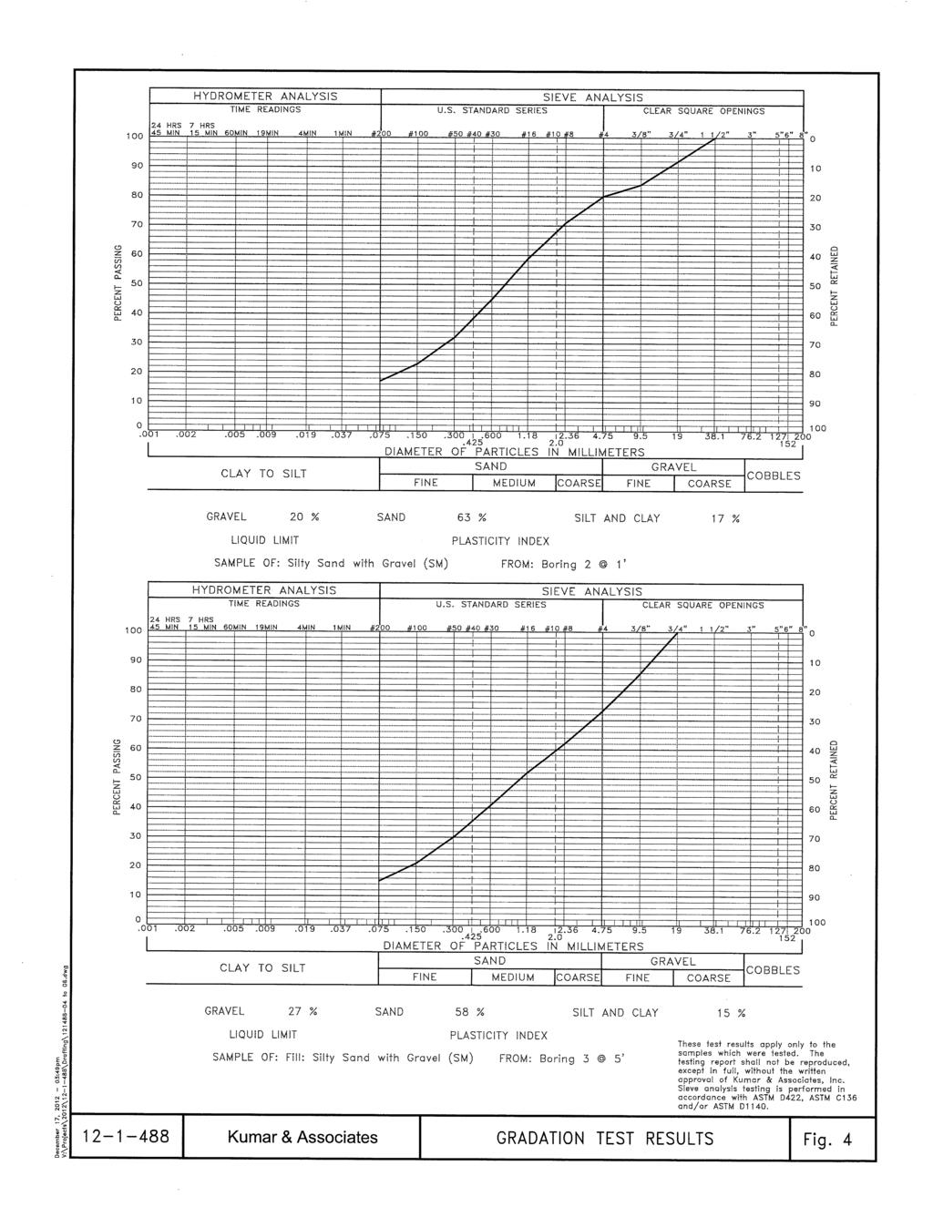
2 Conifer Senior High School Booster Club December 18, 2012 Page 2 If the proposed construction varies significantly from that described above or depicted in this report, we should be notified to reevaluate the recommendations provided in this report. Site Conditions: The project site consists of a synthetic-turf football field located east-northeast of the Senior High School building facility. An asphalt-paved track circles the football field. Rudimentary bleachers are located on the west side of the field. A baseball field is located to the east, a softball field and practice field is located to the west, an access road to the High School facility is located to the south, and vacant land to the north. The original topography within the limits of the athletic fields sloped steeply down from the west to the east. Site grading to accommodate the athletic fields consisted of terracing the topography where significant fills were placed on the east side of the fields and minor cuts on the west side. The overall area was vegetated with natural grasses and medium to large coniferous trees. Subsurface Conditions: To evaluate the subsurface conditions at the site, six exploratory borings were drilled at the approximate locations shown on Fig. 1. Four borings were drilled for the proposed high-mast lighting, one at each approximate light location. The remaining two borings were drilled at the southeastern end of the football field, in the approximate locations of the proposed modular building structures. Graphic logs of the borings along with a legend and notes describing the subsoils encountered are presented on Figs. 2 and 3, respectively. The borings were advanced into the subsoils with 4-inch diameter continuous flight augers. The borings were logged by a representative of Kumar & Associates, Inc. Samples of the soils and bedrock materials were taken with either a 2-inch I.D. California liner sampler or a 1-3/8 inch I.D. standard sampler. The samplers were driven into the various strata with blows from a 140- pound hammer falling 30 inches. The California liner test is similar to the standard penetration test described by ASTM Method D Penetration resistance values, when properly evaluated, indicate the relative density or consistency of the soils. Depths at which the samples were taken and the penetration resistance values are shown on the Logs of Exploratory Borings, Fig. 2. The subsurface conditions encountered in the borings consisted of either 3.5 to 4.5 inches of asphalt or 6 to 12 inches of topsoil overlying areas of man-placed fill underlain by areas of residual soil/high weathered bedrock. Quartz monzonite bedrock was encountered in all of the four borings at depths ranging from 1 foot to 23 feet. The man-placed fill was encountered in 4 borings to depths ranging from 12 to 20 feet. The fill generally consisted of residual soil and bedrock materials excavated locally in the area. The fill generally consisted of silty sand with gravel to silty gravel with sand, fine to coarse grained with cobbles, medium dense to dense, slightly moisture, dark gray, brown and pink. In Borings 2 and 3, residual soil/highly decomposed quartz monzonite was encountered below the topsoil and fill, respectively. The residual soil was silty to occasionally clayey, fine to coarse grained with cobbles, loose to dense, moist, brown, gray pink. Based on a review of applicable geologic data (Reconnaissance Geologic Map of the Conifer Quadrangle, Jefferson County, Colorado, Bryant, 1974) and our knowledge of the site, the bedrock materials are part of the Precambrian, Silver Plume Quartz Monzonite formation. The bedrock materials are coarse-grained to fairly fine grained light-gray to moderate orange-pink muscovite-biotite quartz monzonite. The bedrock contains numemrous inclusions of migamtite, Kumar & Associates, Inc.
3 Conifer Senior High School Booster Club December 18, 2012 Page 3 biotite gneiss, and sillimanite muscovite-biotite schist. As indicated, the bedrock was encountered in all 6 borings at depths ranging from approximately 1 foot to 23 feet. Free groundwater was not encountered in the borings at the time of drilling. Static water level measurements were evaluated in the borings 4 days subsequent to drilling where water was encountered in Boring 1 at a depth of approximately 13.6 feet. Limited laboratory testing was performed on selected samples obtained in the borings. The testing generally consisted of natural moisture content and dry density, gradation analysis, and concentration of water soluble sulfates. The results of the laboratory testing are shown adjacent to the boring logs on Fig. 2, graphically plotted on Figs. 4 through 6, and are summarized in Table I. Gradation analysis test results are presented on Figs. 4 through 6. It should be noted that the method of sampling limits the maximum particle size retrieved to be less than 2 inches. The materials tested for sieve size should be considered to consist of the matrix material between the cobbles which appeared to have a maximum size on the order of 1 to 2 feet. Foundation Recommendations: As indicated, the foundations associated with the structures to be constructed for the improvements are to consist of straight-shaft piers drilled into the underlying bedrock for support of the proposed four high-mast lights, and a shallow footing foundation system for the three modular buildings. Modular Building Structures: Considering the subsurface conditions encountered in the exploratory borings and the nature of the proposed construction, we recommend the facilities building be founded on spread footings placed on undisturbed natural soils and/or suitable existing fill materials. The design and construction criteria presented below should be observed for a spread footing foundation system. The construction details should be considered when preparing project documents. 1. Footings placed on the undisturbed natural soils or suitable fill materials should be designed for an allowable soil bearing pressure of 2,500 psf. 2. Spread footings placed on granular soils should have a minimum footing width of 16 inches for continuous footings and 24 inches for isolated pads. 3. Exterior footings and footings beneath unheated areas should be provided with adequate soil cover above their bearing elevation for frost protection. Placement of foundations at least 36 inches below the exterior grade is typically used in this area. 4. The lateral resistance of a spread footing placed on undisturbed natural soils and/or suitable fill material will be a combination of the sliding resistance of the footing on the foundation materials and passive earth pressure against the side of the footing. Resistance to sliding at the bottoms of the footings can be calculated based on a coefficient of friction of Passive pressure against the sides of the footings can be calculated using an equivalent fluid unit weight of 210 pcf. The above values are working values. Kumar & Associates, Inc.
4 Conifer Senior High School Booster Club December 18, 2012 Page 4 Compacted fill placed against the sides of the footings to resist lateral loads should be an on-site granular material. Fill should be placed and compacted to at least 95% of the standard Proctor (ASTM D 698) maximum dry density at a moisture content within 2 percentage points of optimum. 5. Areas of loose, soft material or deleterious substances encountered within the foundation excavation should be removed and the footings extended to adequate natural bearing material. As an alternate, the loose, soft material or deleterious substances may be removed and replaced with suitable on-site fill material compacted to at least 98% of the standard Proctor (ASTM D 698) maximum dry density within 2 percentage points of the optimum moisture content. New fill should extend down from the edges of the footings at a 1 horizontal to 1 vertical projection. 6. Granular foundation soils should be re-densified with a smooth vibratory compactor just prior to placement of the reinforcing steel and concrete. 7. A representative of the geotechnical engineer should observe all footing excavations prior to concrete placement. High-Mast Lighting: Based on the proposed construction and the data obtained during the field study, we recommend straight-shaft piers drilled into the underlying quartz monzonite bedrock be used to support the proposed high-mast lighting. The design and construction criteria presented below should be observed for a straight-shaft pier foundation system. The construction details should be considered when preparing project documents. 1. Piers should be designed for an allowable end bearing pressure of 40,000 psf and a skin friction of 4,000 psf for the portion of the pier penetration in the quartz monzonite bedrock. Uplift due to structural loadings on the piers can be resisted by using 75% of the allowable skin friction value plus an allowance for pier weight. 2. For axial loading conditions, piers should penetrate at least three pier diameters into the bedrock. The minimum pier length should be based on the lateral load analysis. 3. Piers should be designed to resist lateral loads using a modulus of horizontal subgrade reaction in the fill and residual soils of 75 tcf and a modulus of horizontal subgrade reaction of 350 tcf in the bedrock. The modulus value given is for a long one-foot wide pier and must be corrected for pier size. In the event that a computerized approved is used to evaluate the lateral capacity of the piers, the following table presents the lateral design parameters for the LPILE computer program. These values should be used when analyzing lateral capacity of drilled piers with the LPILE software. Kumar & Associates, Inc.
5 Conifer Senior High School Booster Club December 18, 2012 Page 5 Material c (psf) Ø γ T k s k c Є 50 Existing Fill & Residual Soil Above the Water Level Bedrock 10, , c ø γ T k s k c Є 50 -Cohesion intercept (psf) -Angle of internal friction (degrees) -Total unit weight (pcf) -Initial static modulus of horizontal subgrade reaction (pci) -Initial cyclic modulus of horizontal subgrade reaction (pci) -Strain at 50 percent of peak shear strength Soil Types: 1 Dense Sand above the Groundwater Table 2 Stiff Clay above the Ground Water Table Soil Type 4. Concrete used in the piers should be a fluid mix with sufficient slump so it will fill the void between reinforcing steel and the pier hole. We recommend a concrete slump in the range of 5 to 8 inches be used. 5. Pier holes should be properly cleaned prior to the placement of concrete. 6. The absence of water in the exploratory borings indicates the use of temporary casing or dewatering equipment in the pier holes will probably not be required to reduce water infiltration. However, if water infiltration does occur, the requirements for casing can sometimes be reduced by placing concrete immediately upon cleaning and observing the pier hole. In no case should concrete be placed in more than 3 inches of water unless placed through an improved tremie method. 7. The drilled shaft contractor should mobilize equipment of sufficient size and operating condition to achieve the required bedrock penetration in the bedrock. 8. Concrete should be placed in piers the same day they are drilled. The presence of water or caving soils may require that concrete be placed immediately after the pier hole is completed. Failure to place concrete the day of drilling will normally result in a requirement for additional bedrock penetration. 9. A representative of the geotechnical engineer should observe pier drilling operations on a full-time basis to assist in identification of adequate bedrock strata and monitor pier construction procedures. Water Soluble Sulfates: The concentration of water soluble sulfates measured in samples obtained from the exploratory borings was determined to be less than 0.02%. This concentration of water soluble sulfates represents a Class 0 severity exposure of sulfate attack on concrete exposed to these materials. The degree of attack is based on a range of Class 0, Class 1, Class 2 and Class 3 severity exposure as presented in ACI 201. Based on this information, we believe special sulfate resistant cement will not be required for concrete exposed to the on-site soils. Kumar & Associates, Inc.
6
7
8
9
10
11
12
13
ATTACHMENT A PRELIMINARY GEOTECHNICAL SUMMARY
 ATTACHMENT A PRELIMINARY GEOTECHNICAL SUMMARY Kevin M. Martin, P.E. KMM Geotechnical Consultants, LLC 7 Marshall Road Hampstead, NH 0384 603-489-6 (p)/ 603-489-8 (f)/78-78-4084(m) kevinmartinpe@aol.com
Northern Colorado Geotech
 PRELIMINARY GEOTECHNICAL ENGINEERING REPORT PROPOSED CECIL FARMS DEVELOPMENT WELD COUNTY ROAD 7, BETWEEN ROADS 7 AND 7 SEVERANCE, COLORADO NORTHERN COLORADO GEOTECH PROJECT NO. 0-6 APRIL 0, 06 Prepared
 Project: ITHACA-TOMPKINS REGIONAL AIRPORT EXPANSION Project Location: ITHACA, NY Project Number: 218-34 Key to Soil Symbols and Terms TERMS DESCRIBING CONSISTENCY OR CONDITION COARSE-GRAINED SOILS (major
Civil Engineering, Surveying and Environmental Consulting WASP0059.ltr.JLS.Mich Ave Bridge Geotech.docx
 2365 Haggerty Road South * Canton, Michigan 48188 P: 734-397-3100 * F: 734-397-3131 * www.manniksmithgroup.com August 29, 2012 Mr. Richard Kent Washtenaw County Parks and Recreation Commission 2330 Platt
Limited Geotechnical Engineering Evaluation Classroom Additions Albany County Campus Laramie, Wyoming
 Limited Geotechnical Engineering Evaluation Classroom Additions Albany County Campus 2300 Missile Drive, Cheyenne, Wyoming 82001 Phone 307-635-0222 www.stratageotech.com Limited Geotechnical Engineering
B-1 SURFACE ELEVATION
 5A 5B LOGGED BY El. S. Bhangoo DRILLING CONTRACTOR Pitcher Drilling DRILLING METHOD Rotary Wash BEGIN DATE 12-14-12 SAMPLER TYPE(S) AND SIZE(S) (ID) SPT, MC BOREHOLE BACKFILL AND COMPLETION COMPLETION
 R-1 Conveyor Relocation Project Legend 0 500 1000 1500 ft. This map is a user generated static output from an Internet mapping site and is for general reference only. Data layers that appear on this map
Pierce County Department of Planning and Land Services Development Engineering Section
 Page 1 of 7 Pierce County Department of Planning and Land Services Development Engineering Section PROJECT NAME: DATE: APPLICATION NO.: PCDE NO.: LANDSLIDE HAZARD AREA (LHA) GEOLOGICAL ASSESSMENT REPORT
CITY OF CAPE CORAL NORTH 2 UTILITIES EXTENSION PROJECT CONTRACT 3
 GEOTECHNICAL REPORT CITY OF CAPE CORAL NORTH UTILITIES EXTENSION PROJECT CONTRACT City of Cape Coral Procurement Division Cultural Park Boulevard, nd Floor Cape Coral, FL ISSUED FOR BID VOLUME of GEOTECHNICAL
B-1 BORE LOCATION PLAN. EXHIBIT Drawn By: 115G BROOKS VETERINARY CLINIC CITY BASE LANDING AND GOLIAD ROAD SAN ANTONIO, TEXAS.
 N B-1 SYMBOLS: Exploratory Boring Location Project Mngr: BORE LOCATION PLAN Project No. GK EXHIBIT Drawn By: 115G1063.02 GK Scale: Checked By: 1045 Central Parkway North, Suite 103 San Antonio, Texas 78232
Geotechnical Engineering Report
 Geotechnical Engineering Report Turner Turnpike Widening Bridge B Bridge Crossing: South 257 th West Avenue Creek County, Oklahoma June 1, 2016 Terracon Project No. 04155197 Prepared for: Garver, LLC Tulsa,
PRELIMINARY GEOTECHNICAL ENGINEERING REPORT. Proposed Re-Development 44 Old Worcester Road Charlton, Massachusetts. Prepared For:
 PRELIMINARY GEOTECHNICAL ENGINEERING REPORT Proposed Re-Development 44 Old Worcester Road Charlton, Massachusetts Prepared For: Meridian Associates, Inc. 500 Cummings Center, Suite 5950 Beverly, Massachusetts
DATA REPORT GEOTECHNICAL INVESTIGATION GALVESTON CRUISE TERMINAL 2 GALVESTON, TEXAS
 DATA REPORT GEOTECHNICAL INVESTIGATION GALVESTON CRUISE TERMINAL 2 GALVESTON, TEXAS SUBMITTED TO PORT OF GALVESTON 123 ROSENBERG AVENUE, 8TH FLOOR GALVESTON, TEXAS 77553 BY HVJ ASSOCIATES, INC. HOUSTON,
M E M O R A N D U M. Mr. Jonathan K. Thrasher, P.E., Mr. Ian Kinnear, P.E. (FL) PSI
 PSI") M E M O R A N D U M TO: FROM: Mr. Mark Schilling Gulf Interstate Engineering Mr. Jonathan K. Thrasher, P.E., Mr. Ian Kinnear, P.E. (FL) PSI DATE: November 11, 2014 RE: Summary of Findings Geotechnical
M E M O R A N D U M TO: FROM: Mr. Mark Schilling Gulf Interstate Engineering Mr. Jonathan K. Thrasher, P.E., Mr. Ian Kinnear, P.E. (FL) PSI DATE: November 11, 2014 RE: Summary of Findings Geotechnical
Preliminary Geotechnical Evaluation Gooseberry Point Pedestrian Improvements Whatcom County, Washington SITE AND PROJECT DESCRIPTION
 File No. 12-100 Geotechnical & Earthquake Engineering Consultants Mr. Kevin Brown, P.E. Gray & Osborne, Inc. 3710 168 th Street NE, Suite B210 Arlington, Washington 98223 Subject: Draft Report Preliminary
APPENDIX E SOILS TEST REPORTS
 Otsego County, NY Site Work Specifications APPENDIX E SOILS TEST REPORTS Blue Wing Services, Inc. July 1, 2010 Blue Wing Services May 20, 2010 Page 2 the site, was not made available to Empire at this
Appendix A. Producer Statement Advisory Note
 Appendix A Producer Statement Advisory Note Ref. No. 17095 26 May 2017 PRODUCER STATEMENT CONSTRUCTION REVIEW (PS4) IMPORTANT ADVISORY NOTE The Building Consent Authority (BCA) frequently requires Producer
REPORT OF PRELIMINARY GEOTECHNICAL EXPLORATION
 REPORT OF PRELIMINARY GEOTECHNICAL EXPLORATION ENKA INTERMEDIATE SCHOOL Sand Hill Road Candler, North Carolina Prepared For: BUNCOMBE COUNTY SCHOOLS Prepared By: AMEC ENVIRONMENT & INFRASTRUCTURE, INC.
 SOIL CLASSIFICATION CHART COARSE-GRAINED SOILS MORE THAN 50% RETAINED ON NO.200 SIEVE FINE-GRAINED SOILS 50% OR MORE PASSES THE NO.200 SIEVE PRIMARY DIVISIONS GRAVELS MORE THAN 50% OF COARSE FRACTION RETAINED
PREPARED FOR MR. JOE WOOD CARTER & SLOOPE, INC PEAKE ROAD MACON, GEORGIA PREPARED BY
 SUBSURFACE EXPLORATION AND GEOTECHNICAL ENGINEERING EVALUATION MACON WATER AUTHORITY (MWA) SANITARY SEWER RELOCATION MACON, GEORGIA GEC PROJECT NO. 14077.2 PREPARED FOR MR. JOE WOOD CARTER & SLOOPE, INC.
Preliminary Geotechnical Investigation Cadiz / Trigg County I-24 Business Park. Cadiz, Kentucky
 Environmental & Geoscience, LLC 834 Madisonville Road Hopkinsville, KY 440 70.44.000 FAX 70.44.8300 www.wedrill.com A member of Trinity Energy & Infrastructure Group, LLC Preliminary Geotechnical Investigation
AN EMPLOYEE OWNED COMPANY
 CTL Engineering, Inc. 2860 Fisher Road, P.O. Box 4448, Columbus, Ohio 43204338 Phone: 614/2768123 Fax: 614/2766377 Email: ctl@ctleng.com AN EMPLOYEE OWNED COMPANY Consulting Engineers Testing Inspection
Geotechnical Investigation Juneau Seawalk - Taku Fisheries to Miner s Wharf Juneau, Alaska DM&A Job No
 Duane Miller & Associates 5821 Arctic Boulevard, Suite A Anchorage, AK 99518-1654 (907) 644-3200 Fax 644-0507 Arctic & Geotechnical Engineering May 4, 2006 Tetra Tech/KCM, Inc. 1971 First Avenue Seattle,
Geotechnical Recommendations for Proposed Additions to the Three Mile Creek Severe Weather Attenuation Tank Project
 TECHNICAL MEMORANDUM Geotechnical Recommendations for Proposed Additions to the Three Mile Creek Severe Weather Attenuation Tank Project PREPARED FOR: PREPARED BY: DATE: June 28, 218 PROJECT NUMBER: 697482
February 22, 2016 AG File No
 Ainley Graham & Associates Limited 1-50 Grant Timmins Drive, Kingston, Ontario, K7M 8N2 Tel: (343) 266-0002 Fax: (343) 266-0028 E-mail Kingston@ainleygroup.com February 22, 2016 AG File No. 15062-1 Ministry
Ardaman & Associates, Inc. Geotechnical, Environmental and Materials Consultants
 SUBSURFACE SOIL EXPLORATION ANALYSIS AND RECOMMENDATIONS LELY AREA STORMWATER IMPROVEMENT PROJECT (LASIP) COUNTY BARN ROAD AND WING SOUTH CHANNELS NAPLES, COLLIER CO., FLORIDA Ardaman & Associates, Inc.
Reference No S072 APRIL 2012
 A REPORT TO SOLMAR DEVELOPMENT CORP. A PRELIMINARY SOIL INVESTIGATION FOR PROPOSED SUBDIVISION DEVELOPMENT NORTHEAST OF SIDEROAD 5 AND 0 LINE TOWN OF ERIN Reference No. 202-S072 APRIL 202 DISTRIBUTION
APPENDIX C HYDROGEOLOGIC INVESTIGATION
 Figure B-5.7 Figure B-5.8 Preliminary Geotechnical and Environmental Report Appendix C Hydrogeologic Investigation APPENDIX C HYDROGEOLOGIC INVESTIGATION December 21, 2011 WESTSIDE SUBWAY EXTENSION PROJECT
FINAL GEOTECHNICAL INVESTIGATION BURNS BRIDGE REPLACEMENT COLORADO RIVER ROAD BURNS, COLORADO. December 12, 2012
 FINAL GEOTECHNICAL INVESTIGATION BURNS BRIDGE REPLACEMENT COLORADO RIVER ROAD BURNS, COLORADO December 12, 2012 Prepared For: AMEC Environment & Infrastructure 2000 South Colorado Boulevard, Suite 21000
 Photo 1 - Southerly view across 2700 parking lot toward existing building. Multi-residential building borders western side of property in upper right of view. Photo 2 - Southerly view across 2750 parking
NAPLES MUNICIPAL AIRPORT
 NAPLES MUNICIPAL AIRPORT NAPLES MUNICIPAL AIRPORT (APF) TAXIWAY D REALIGNMENT AND DRAINAGE IMPROVEMENTS NORTH QUADRANT ADDENDUM NUMBER TWO March, The following Addendum is hereby made a part of the Plans
IV. ENVIRONMENTAL IMPACT ANALYSIS G. GEOLOGY AND SOILS
 IV. ENVIRONMENTAL IMPACT ANALYSIS G. GEOLOGY AND SOILS The following section is a summary of the geotechnical report conducted for the proposed project. The Report of Geotechnical Investigation Proposed
Slope Stability Evaluation Ground Anchor Construction Area White Point Landslide San Pedro District Los Angeles, California.
 Slope Stability Evaluation Ground Anchor Construction Area White Point Landslide San Pedro District Los Angeles, California Submitted To: Mr. Gene Edwards City of Los Angeles Department of Public Works
Geotechnical Data Report
 Geotechnical Data Report Downtown Greenville Future Conveyance Study December 1, 2015 Terracon Project No. 86155032 Prepared for: Prepared by: Terracon Consultants, Inc. December 1, 2015 561 Mauldin Road
ENCE 3610 Soil Mechanics. Site Exploration and Characterisation Field Exploration Methods
 ENCE 3610 Soil Mechanics Site Exploration and Characterisation Field Exploration Methods Geotechnical Involvement in Project Phases Planning Design Alternatives Preparation of Detailed Plans Final Design
SITE INVESTIGATION 1
 SITE INVESTIGATION 1 Definition The process of determining the layers of natural soil deposits that will underlie a proposed structure and their physical properties is generally referred to as site investigation.
REPORT OF SUBSURFACE EXPLORATION
 REPORT OF SUBSURFACE EXPLORATION GRAND RIVER DAM AUTHORITY HULBERT 69 KV SWITCHING STATION S. 440 Road Hulbert, Cherokee County, Oklahoma ENERCON PROJECT NO. GRDA006 MARCH 7, 2012 PREPARED FOR: C/O ENERCON
June 9, R. D. Cook, P.Eng. Soils Engineer Special Services Western Region PUBLIC WORKS CANADA WESTERN REGION REPORT ON
 PUBLIC WORKS CANADA WESTERN REGION REPORT ON GEOTECHNICAL INVESTIGATION PROPOSED MARTIN RIVER BRIDGE MILE 306.7 MACKENZIE HIGHWAY Submitted by : R. D. Cook, P.Eng. Soils Engineer Special Services Western
General. DATE December 10, 2013 PROJECT No TO Mary Jarvis Urbandale/Riverside South Development Corporation
 DATE December 10, 201 PROJECT No. 10-1121-0260- TO Mary Jarvis Urbandale/Riverside South Development Corporation CC Justin Robitaille, Urbandale Jonathan Párraga, J.L. Richards & Associates Limited FROM
DRILLED DISPLACMENT PILE PERFORMANCE IN COASTAL PLAIN AND RESIDUAL SOILS
 DRILLED DISPLACMENT PILE PERFORMANCE IN COASTAL PLAIN AND RESIDUAL SOILS Presented by: W. Morgan NeSmith, P.E. Berkel & Company Contractors Inc. 770.941.5100 mnesmith@berkelapg.com SC Engineering Conference
Mitigation of Liquefaction Potential Using Rammed Aggregate Piers
 ASCE 2011 557 Mitigation of Liquefaction Potential Using Rammed Aggregate Piers R.W. Rudolph, M. ASCE, G.E. 1, B. Serna, M. ASCE, P.E. 2, and T. Farrell, M. ASCE, G.E. 3 1 Principal Consultant, ENGEO,
16 January 2018 Job Number: RICHARD NEWMAN C\- CLARK FORTUNE MCDONALD AND ASSOCIATES PO BOX 553 QUEENSTOWN
 16 January 2018 Job Number: 50595 RICHARD NEWMAN C\- CLARK FORTUNE MCDONALD AND ASSOCIATES PO BOX 553 QUEENSTOWN CHANSEN@CFMA.CO.NZ STORMWATER DISPOSAL ASSESSMENT Dear Richard, RDAgritech were requested
PRELIMINARY GEOTECHNICAL ENGINEERING REPORT
 PRELIMINARY GEOTECHNICAL ENGINEERING REPORT TOWN OF ASHLAND TOWN HALL 101 THOMPSON STREET ASHLAND, VIRGINIA JOB NUMBER: 39016 PREPARED FOR: PMA PLANNERS & ARCHITECTS 10325 WARWICK BOULEVARD NEWPORT NEWS,
PRELIMINARY GEOTECHNICAL REPORT. State College Redevelopment State College Borough, Centre County, Pennsylvania. CMT Laboratories File No.
 PRELIMINARY GEOTECHNICAL REPORT State College Redevelopment State College Borough, Centre County, Pennsylvania CMT Laboratories File No. 1638700 Prepared for: National Development Council One Battery Park
GEOTECHNICAL REPORT CBSA Facility Redevelopment Thousand Islands International Crossing Lansdowne, Ontario
 GEOTECHNICAL REPORT CBSA Facility Redevelopment Thousand Islands International Crossing Lansdowne, Ontario Prepared For: The Federal Bridge Corporation Limited SPL Project No.: 10001084 Report Date: January
Report of Preliminary Geotechnical Exploration. CSO-012 Sewer Separation Cincinnati, Hamilton County, Ohio. February, 2011
 11242843_GeoTech_Preliminary - Feburary 2011_1/40 Report of Preliminary Geotechnical Exploration CSO-012 Sewer Separation Cincinnati, Hamilton County, Ohio February, 2011 11242843_GeoTech_Preliminary -
EIGHT POINT WIND LLC
 GEOTECHNICAL INVESTIGATION REPORT PRELIMINARY EIGHT POINT WIND FARM WIND TURBINES AND TRANSMISSION LINE STEUBEN COUNTY NEW YORK PREPARED FOR EIGHT POINT WIND LLC 700 UNIVERSE BLVD. JUNO BEACH, FL 33408
Geotechnical Engineering Report
 Geotechnical Engineering Report Turner Turnpike Widening Polecat Creek Bridge (Bridge A) June 1, 2016 Terracon Project No. 04155197 Prepared for: Garver, LLC Prepared by: Terracon Consultants, Inc. TABLE
SUBSURFACE EXPLORATION AND SUBGRADE EVALUATION. Proposed North Main Street Reconstruction (Contract 14-02) From New York Avenue and Murdoch Avenue
 From New York Avenue and Murdoch Avenue") SUBSURFACE EXPLORATION AND SUBGRADE EVALUATION Proposed North Main Street Reconstruction (Contract 14-02) From New York Avenue and Murdoch Avenue Prepared for City of Oshkosh Department of Public Works
SUBSURFACE EXPLORATION AND SUBGRADE EVALUATION Proposed North Main Street Reconstruction (Contract 14-02) From New York Avenue and Murdoch Avenue Prepared for City of Oshkosh Department of Public Works
The process of determining the layers of natural soil deposits that will underlie a proposed structure and their physical properties is generally
 The process of determining the layers of natural soil deposits that will underlie a proposed structure and their physical properties is generally referred to as sub surface investigation 2 1 For proper
Depth (ft) USCS Soil Description TOPSOIL & FOREST DUFF
 USCS Soil Description TOPSOIL & FOREST DUFF") Test Pit No. TP-6 Location: Latitude 47.543003, Longitude -121.980441 Approximate Ground Surface Elevation: 1,132 feet Depth (ft) USCS Soil Description 0 1.5 1.5 5.0 SM 5.0 8.0 SM Loose to medium dense,
Test Pit No. TP-6 Location: Latitude 47.543003, Longitude -121.980441 Approximate Ground Surface Elevation: 1,132 feet Depth (ft) USCS Soil Description 0 1.5 1.5 5.0 SM 5.0 8.0 SM Loose to medium dense,
Chapter 12 Subsurface Exploration
 Page 12 1 Chapter 12 Subsurface Exploration 1. The process of identifying the layers of deposits that underlie a proposed structure and their physical characteristics is generally referred to as (a) subsurface
Should you have any questions regarding this clarification, please contact the undersigned at or (925)
") October 8, 2015 Revised October 13, 2015 Contra Costa Community College District 500 Court Street Martinez, CA 94553 Attention: Ron Johnson Subject: Clarification of Grading Requirements Diablo Valley
October 8, 2015 Revised October 13, 2015 Contra Costa Community College District 500 Court Street Martinez, CA 94553 Attention: Ron Johnson Subject: Clarification of Grading Requirements Diablo Valley
UNDP HARARE HOSPITAL PROPOSED NATPHARM WAREHOUSE
 UNDP HARARE HOSPITAL PROPOSED NATPHARM WAREHOUSE January 17 2016 TO CARRY OUT IN-SITU SOIL SURVEY, LABORATORY TESTS AND GEOTECHNICAL REPORTING. GEOTECHNICAL INVESTIGATIONS REPORT 1 2 Re: GEOTECHNICAL INVESTIGATIONS
SUPPLEMENTARY INVESTIGATION AND LABORATORY TESTING Aggregate Resource Evaluation Proposed Bernand Quarry San Diego County, California
 October 3, 2 Mr. Mark San Agustin Project No. 28-- Home Land Investments Document No. -92 2239 Curlew Street San Diego, CA 92 SUBJECT: SUPPLEMENTARY INVESTIGATION AND LABORATORY TESTING Aggregate Resource
Background. Valley fills Sites in the Area. Construction over Mine Spoil Fills
 Construction over Mine Spoil Fills Wayne A. Karem, PhD, PE, PG, D.GE 2014 KSPE Annual Conference Background Strip mining; mountaintop and contour mining Creates huge quantities of mine spoil The mine spoil
 TP-1 N61E 0 DARK BROWN SANDY SILT (ML) stiff, wet with roots (Disturbed Surficial Soil) DEPTH (FEET) 5 REDDISH BROWN SANDSTONE intensely fractured, weak to friable, deeply weathered, tight (Franciscan
patersongroup Consulting Engineers April 20, 2010 File: PG1887-LET.01R Novatech Engineering Consultants Suite 200, 240 Michael Cowpland Drive
 patersongroup April 20, 2010 File: PG1887-LET.01R Novatech Engineering Consultants Suite 200, 240 Michael Cowpland Drive Ottawa, Ontario K2M 1P6 Attention: Mr. Adam Thompson Consulting Engineers 28 Concourse
December 5, Junction Gateway, LLC 7551 W. Sunset Boulevard #203 Los Angeles, CA Mr. James Frost P: Dear Mr.
 December 5, 2014 Junction Gateway, LLC 7551 W. Sunset Boulevard #203 90046 Attn: Re: Mr. James Frost P: 323.883.1800 Geotechnical Update Letter Sunset & Effie Mixed Use Development 4301 to 4311 Sunset
GEOTECHNICAL INVESTIGATION REPORT INFRASTRUCTURE PVT LTD
 GEOTECHNICAL INVESTIGATION REPORT Client : TAEIN CONSTRUCTION & INFRASTRUCTURE PVT LTD Office address : Flat No.104, A -Wing,1st floor,gloria Park, Paranjape Scheme, Bavdhan Khurd, Chandni Chowk, Pune
Geotechnical Engineering Report
 Geotechnical Engineering Report Turner Turnpike Widening Bridge D Bridge Crossing: South 209 th West Avenue Creek County, Oklahoma June 1, 2016 Terracon Project No. 04155197 Prepared for: Garver, LLC Tulsa,
Introduction to Soil Mechanics Geotechnical Engineering-II
 Introduction to Soil Mechanics Geotechnical Engineering-II ground SIVA Dr. Attaullah Shah 1 Soil Formation Soil derives from Latin word Solum having same meanings as our modern world. From Geologist point
Table of Contents. Description
 Table of Contents Description Page A. Introduction... 1 A.1. Project Description... 1 A.2. Site Conditions and History... 2 A.3. Purpose... 3 A.4. Background Information and Reference Documents... 4 A.5.
Converse Consultants Geotechnical Engineering, Environmental & Groundwater Science, Inspection & Testing Services
 Converse Consultants Geotechnical Engineering, Environmental & Groundwater Science, Inspection & Testing Services Ms. Rebecca Mitchell Mt. San Antonio College Facilities Planning & Management 1100 North
May 8, Mr. Jeff Dingman Abundant Land Partners LLC P.O. Box 471 Genoa, Nevada 89411
 Construction Materials Testing Geotechnical Engineering Environmental Consulting May 8, 2014 Mr. Jeff Dingman Abundant Land Partners LLC P.O. Box 471 Genoa, Nevada 89411 RE: Geotechnical Evaluation Stimson
USE OF GEOPHYSICAL SURVEYS FOR FILL CHARACTERIZATION AND QUANTITY ESTIMATION AT BROWNFIELD SITES A CASE HISTORY. Abstract
 USE OF GEOPHYSICAL SURVEYS FOR FILL CHARACTERIZATION AND QUANTITY ESTIMATION AT BROWNFIELD SITES A CASE HISTORY John A. Mundell, Mundell & Associates, Inc., Indianapolis, IN Gregory B. Byer, Mundell &
APPENDIX C. Borehole Data
 APPENDIX C Borehole Data MAJOR DIVISIONS SOIL CLASSIFICATION CHART SYMBOLS GRAPH LETTER TYPICAL DESCRIPTIONS ADDITIONAL MATERIAL
F_._G_. _.E_._,_L_T_D_ ~-11'-~~L ~
 : e 99o'3 (} rr WtR!'~ _;, F G E,_L_T_D_ ~11'~~L ~ Fewell Geotechhicai Engineering, Ltd 3 2825 Koapaka St Honolulu, Hawaii 96819 (88) 8362171 {/~ ' File No 328,1 October 29, 198 Mr Evan Cruthers c/o Media
Preliminary Geotechnical Engineering Report
 Preliminary Geotechnical Engineering Report Park 3 Barrow County, Georgia July, Terracon Project No. 4906 Prepared For: Winder Barrow Industrial Authority Prepared By: Terracon Consultants, Inc. Atlanta,
Safe bearing capacity evaluation of the bridge site along Syafrubesi-Rasuwagadhi road, Central Nepal
 Bulletin of the Department of Geology Bulletin of the Department of Geology, Tribhuvan University, Kathmandu, Nepal, Vol. 12, 2009, pp. 95 100 Safe bearing capacity evaluation of the bridge site along
Theory of Shear Strength
 SKAA 1713 SOIL MECHANICS Theory of Shear Strength Prepared by, Dr. Hetty 1 SOIL STRENGTH DEFINITION Shear strength of a soil is the maximum internal resistance to applied shearing forces The maximum or
NEW DOWN-HOLE PENETROMETER (DHP-CIGMAT) FOR CONSTRUCTION APPLICATIONS
 FOR CONSTRUCTION APPLICATIONS") NEW DOWN-HOLE PENETROMETER (DHP-CIGMAT) FOR CONSTRUCTION APPLICATIONS 1 2 C. Vipulanandan 1, Ph.D., M. ASCE and Omer F. Usluogullari 2 Chairman, Professor, Director of Center for Innovative Grouting Materials
NEW DOWN-HOLE PENETROMETER (DHP-CIGMAT) FOR CONSTRUCTION APPLICATIONS 1 2 C. Vipulanandan 1, Ph.D., M. ASCE and Omer F. Usluogullari 2 Chairman, Professor, Director of Center for Innovative Grouting Materials
TIERRA. Florida License No Florida License No
 March 9, 208 TIERRA AECOM 7650 West Courtney Campbell Cswy Tampa, FL 33607 Attn: RE: Mr. Edgar Figueroa, P.E. Geotechnical Engineering Services Report Purchase Order No.: 9532 AECOM Project Number: 6055499
Appendix 11-B Preliminary Geotechnical Investigation
 Appendix 11-B Preliminary Geotechnical Investigation 11.0 Soil, Geology, and Seismology PRELIMINARY SUBSURFACE EXPLORATION AND CONCEPTUAL FOUNDATION ENGINEERING REPORT CPV VALLEY ENERGY CENTER Wawayanda,
Ardaman & Associates, Inc. Geotechnical, Environmental and Materials Consultants
 SUBSURFACE SOIL EXPLORATION 42-INCH FORCE MAIN REPLACEMENT CHIQUITA BOULEVARD S AND SW 34 TH STREET CAPE CORAL, LEE COUNTY, FLORIDA Ardaman & Associates, Inc. Geotechnical, Environmental and Materials
Town of Amenia Dutchess County New York
 Appendix 9.14.2 Preliminary Geotechnical Investigation 2/2007 Preliminary Geotechnical Interpretive Report for Silo Ridge Golf Resort Community Town of Amenia Dutchess County New York February 16, 2007
How & Where does infiltration work? Summary of Geologic History Constraints/benefits for different geologic units
 June 26, 2007: Low Impact Development 1 Associated Earth Sciences, Inc. Associated Earth Sciences, Inc. Presented by: Matthew A. Miller, PE April 24, 2012 How & Where does infiltration work? Summary of
Prepared for: MEADOWBROOK CROSSING, LLC 90 South Cascade Avenue, Suite 1500 Colorado Springs, Colorado Attention: Mr.
 GEOLOGIC HAZARDS EVALUATION AND PRELIMINARY GEOTECHNICAL INVESTIGATION SUBDIVISION MEADOWBROOK PARKWAY & STATE HIGHWAY 94 EL PASO COUNTY, COLORADO Prepared for:, LLC 90 South Cascade Avenue, Suite 1500
Geotechnical Engineering Report
 Geotechnical Engineering Report Richland Creek Trunk Sewer Greenville, South Carolina March 31, 2014 Terracon Project No. 86145008 Prepared for: Renewable Water Resources Greenville, South Carolina Prepared
Prepared for: Stephens Farm Investments, LLC 7251 West 20 th Street, L-200 Greeley, Colorado Attn: Mr. Andrew Gerk
 PRELIMINARY GEOTECHNICAL EXPLORATION REPORT STEPHENS FARM SINGLE FAMILY RESIDENTIAL DEVELOPMENT WEST 10 TH STREET AND 83 RD AVENUE GREELEY, COLORADO EEC PROJECT NO. 1162110 Prepared for: Stephens Farm
LEGEND ODOT CLASS A-3. A-3a. A-4a. A-6a. A-6b TOTAL VISUAL VISUAL VISUAL BORING LOCATION - PLAN VIEW
 PROJECT THE PROJECT CONSISTS IN PART OF CONSTRUCTING A SINGLE-SPAN BRIDGE ON RELOCATED SHUMWAY HOOW ROAD OVER THE CSXT RAILROAD. THE STRUCTURE AS ANNED, IS A SINGLE-SPAN STRUCTURE WITH MSE WAS AT THE ABUTMENTS.
ADDENDUM 1 FISHER SLOUGH RESTORATION PROJECT SKAGIT COUNTY, WASHINGTON
 F I N A L A D D E N D U M 1 R E P O R T ADDENDUM 1 FISHER SLOUGH RESTORATION PROJECT SKAGIT COUNTY, WASHINGTON REPORT OF GEOTECHNICAL INVESTIGATION URS JOB NO. 3376186 Prepared for Tetra Tech Inc. 142
IN SITU SPECIFIC GRAVITY VS GRAIN SIZE: A BETTER METHOD TO ESTIMATE NEW WORK DREDGING PRODUCTION
 IN SITU SPECIFIC GRAVITY VS GRAIN SIZE: A BETTER METHOD TO ESTIMATE NEW WORK DREDGING PRODUCTION Nancy Case O Bourke, PE 1, Gregory L. Hartman, PE 2 and Paul Fuglevand, PE 3 ABSTRACT In-situ specific gravity
APPENDIX F CORRELATION EQUATIONS. F 1 In-Situ Tests
 APPENDIX F 1 APPENDIX F CORRELATION EQUATIONS F 1 In-Situ Tests 1. SPT (1) Sand (Hatanaka and Uchida, 1996), = effective vertical stress = effective friction angle = atmosphere pressure (Shmertmann, 1975)
Geotechnical Subsurface Exploration, Engineering Evaluation and Dam Visual Observation Sun Valley Drive Extension Roswell, Fulton County, GA
 Ranger Consulting, Inc. Geotechnical, Environmental, Drilling, Construction 3147 Martha Berry Highway, Rome, Georgia 165; Phone: 76-29-1782; Fax: 76-29-171 April 2, 215 Mr. Tommy Crochet, PE McGee Partners,
Theory of Shear Strength
 MAJ 1013 ADVANCED SOIL MECHANICS Theory of Shear Strength Prepared by, Dr. Hetty 1 Strength of different materials Steel Concrete Soil Tensile strength Compressive strength Shear strength Complex behavior
APPENDIX B GEOTECHNICAL INVESTIGATION
 APPENDIX B GEOTECHNICAL INVESTIGATION INTENTIONALL LEFT BLANK GEOTECHNICAL INVESTIGATION 2016 SEWER AND WATER GROUP 1 CIP, WATER PROJECT 1 15 TH STREET AND AVENIDA PRIMAVERA DEL MAR, CALIFORNIA PREPARED
(C) Global Journal of Engineering Science and Research Management
 Global Journal of Engineering Science and Research Management") GEOTECHNCIAL ASSESSMENT OF PART OF PORT HARCOURT, NIGER DELTA FOR STRUCTURAL ANALYSIS Warmate Tamunonengiyeofori Geostrat International Services Limited, www.geostratinternational.com. *Correspondence
GEOTECHNCIAL ASSESSMENT OF PART OF PORT HARCOURT, NIGER DELTA FOR STRUCTURAL ANALYSIS Warmate Tamunonengiyeofori Geostrat International Services Limited, www.geostratinternational.com. *Correspondence
Project No: 68R3056 Client: City of Frederick Project: RFQ 14-H Future North Side Water Tank City/State: 7516 Hayward Road, Frederick, MD
 Boring: SB-1 (1 of 1) Moist, brown to orange brown CLAY and SILT, trace sand with fine weathered rock fragments. POSSIBLE FILL. Dry, orange brown sandy SILT trace clay (SM-ML). RESIDUAL SOIL : Not Surveyed
Date: April 2, 2014 Project No.: Prepared For: Mr. Adam Kates CLASSIC COMMUNITIES 1068 E. Meadow Circle Palo Alto, California 94303
 City of Newark - 36120 Ruschin Drive Project Draft Initial Study/Mitigated Negative Declaration Appendix C: Geologic Information FirstCarbon Solutions H:\Client (PN-JN)\4554\45540001\ISMND\45540001 36120
REPORT OF PRELIMINARY SUBSURFACE EXPLORATION SITE DESIGN EVALUATION FOR REHABILITATION OF PINE GROVE LAKE DAM
 REPORT OF PRELIMINARY SUBSURFACE EXPLORATION SITE DESIGN EVALUATION FOR REHABILITATION OF PINE GROVE LAKE DAM VILLAGE OF SLOATSBURG, ROCKLAND COUNTY, NEW YORK SUBMITTED TO: ASSOCIATION OF PROPERTY OWNERS
ARCH 1250 APPLIED ENVIRONMENTAL STUDIES
 John Seitz, RA, LEED AP Assistant Adjunct Professor Professor Paul C. King, RA, AIA, ARA Assistant Professor Geology Geology is the scientific study of the structure and composition of the earth s surface
GEOTECHNICAL REPORT. Matanuska-Susitna Borough. Parks Highway Connections Museum Drive. Matanuska-Susitna Borough, Alaska.
 Matanuska-Susitna Borough GEOTECHNICAL REPORT Parks Highway Connections Museum Drive Matanuska-Susitna Borough, Alaska March 2, 20 Prepared By: John Thornley, PE Geotechnical Engineer 333 Arctic Blvd.,
December 8, 2016 EEI Project No Mr. Gary Cowles Cowles, Murphy Glover & Associates, LLC 457 St. Michael Street Mobile, Alabama 36602
 December, 2016 EEI Project No. 29192.00 Mr. Gary Cowles Cowles, Murphy Glover & Associates, LLC 457 St. Michael Street Mobile, Alabama 36602 Phone: 2514331611 Fax: 2514331411 email: gcowles@cmga.com Re:
Geotechnical Investigation
 Geotechnical Investigation Slope Stability Analysis for the Existing Slope Southwest of the Proposed Condo Developments 50 Ann Street, Bolton, Ontario Prepared For: Brookfield Homes (Ontario) Limited GeoPro
INVITATION TO BID CITY OF CAPE CORAL SW 6&7 UTILITIES EXTENSION PROJECT CONTRACT VII CENTRAL AREA 6 AND CENTRAL AREA 8 ITB UT13-02/TM-G
 GEOTECHNICAL REPORT INVITATION TO BID CITY OF CAPE CORAL SW 6&7 UTILITIES EXTENSION PROJECT CONTRACT VII CENTRAL AREA 6 AND CENTRAL AREA 8 ITB UT13-02/TM-G City of Cape Coral Procurement Division 1015
(THIS IS ONLY A SAMPLE REPORT OR APPENDIX OFFERED TO THE USERS OF THE COMPUTER PROGRAM
 C A U T I O N!! (THIS IS ONLY A SAMPLE REPORT OR APPENDIX OFFERED TO THE USERS OF THE COMPUTER PROGRAM EQLique&Settle2. THE AUTHOR IS HEREBY RELEASED OF ANY LIABILITY FOR ANY INCORRECT USE OF THIS SAMPLE
LEGEND ODOT CLASS. A-4b. A-6a. A-6b TOTAL VISUAL WEATHERED SANDSTONE VISUAL BORING LOCATION - PLAN VIEW
 PROJECT THE PROJECT CONSISTS IN PART OF ACING TWO STRUCTURES, EASTBOUND AND WESTBOUND STRUCTURES, RESPECTIVELY FOR THE PROPOSED SR OVER BLUE ROAD (CR 9). THE TWO STRUCTURES AS ANNED, ARE SINGLE-SPAN STRUCTURES
SLOPE STABILITY ASSESSMENT PROPOSED RESIDENTIAL SUBDIVISION 161 LAKESHORE ROAD EAST TOWN OF THE BLUE MOUNTAINS, ONTARIO
 SLOPE STABILITY ASSESSMENT PROPOSED RESIDENTIAL SUBDIVISION 161 LAKESHORE ROAD EAST TOWN OF THE BLUE MOUNTAINS, ONTARIO PETO MacCALLUM LTD. 19 CHURCHILL DRIVE BARRIE, ONTARIO L4N 8Z5 PHONE: (705) 734-3900
CHRISTIAN WHEELER E N G I N E E R I N G
 CHRISTIAN WHEELER E N G I N E E R I N G REPORT OF GEOTECHNICAL INVESTIGATION PROPOSED FOUNDATION UNDERPINNING SMOKETREE CONDOMINIUMS, BUILDINGS 8 AND 9 6050 HENDERSON DRIVE LA MESA, CALIFORNIA SUBMITTED