May 8, Mr. Jeff Dingman Abundant Land Partners LLC P.O. Box 471 Genoa, Nevada 89411
|
|
|
- Thomasine Johnson
- 6 years ago
- Views:
Transcription
1

2 Construction Materials Testing Geotechnical Engineering Environmental Consulting May 8, 2014 Mr. Jeff Dingman Abundant Land Partners LLC P.O. Box 471 Genoa, Nevada RE: Geotechnical Evaluation Stimson Mill Site Redevelopment 3074 Seltice Way Coeur d Alene, Idaho ALLWEST Project No.: G Dear Mr. Dingman, ALLWEST Testing & Engineering, LLC has completed the authorized geotechnical evaluation for the proposed redevelopment project located at the Stimson Mill Site at the above referenced location in Coeur d Alene, Idaho. The purpose of this evaluation was to characterize the soil and geologic conditions on the property. The attached report presents the results of the field evaluation and our recommendations to assist with design and construction of the proposed project. We appreciate the opportunity to work with you on this project. If you have any questions or need additional information, please do not hesitate to call us at (208) Sincerely, ALLWEST Testing & Engineering, LLC Colin Meehan, P.E. Hayden Area Manager Shawn Turpin, P.E. Lewiston Area Manager 690 W. Capstone Court Hayden, ID (208) Fax (208)
3 TABLE OF CONTENTS ALLWEST Project No G Stimson Mill Site Coeur d Alene, Idaho Page 1.0 SCOPE OF SERVICES PROJECT DESCRIPTION EVALUATION PROCEDURES SITE CONDITIONS General Geologic Conditions General Soil Conditions Hydrogeologic Conditions SUBSURFACE CONDITIONS Subsurface Soil Conditions Groundwater Conditions LABORATORY TESTING CONCLUSIONS AND RECOMMENDATIONS Planning Considerations Site Preparation Excavation Fill Placement and Compaction Wet Weather Construction Cold Weather Construction Foundation Recommendations Pavement Recommendations Storm Water and Drainage Erosion Control ADDITIONAL RECOMMENDED SERVICES EVALUATION LIMITATIONS Appendix A Vicinity Map, Boring and Test Pit Location Map Appendix B Boring and Test Pit Logs, Unified Soil Classification System Appendix C Laboratory Test Results Appendix D Aerial Images
4 GEOTECHNICAL EVALUATION STIMSON MILL SITE 3074 W. SELTICE WAY COEUR D ALENE, IDAHO ALLWEST Testing & Engineering, LLC (ALLWEST) has completed the authorized geotechnical evaluation for the northeast portion of the Stimson Mill Site located at 3074 W. Seltice Way in Coeur d Alene, Idaho. The general location of the project is shown on the Vicinity Map, Figure A-1, in Appendix A of this report. The purpose of the evaluation was to assess the subsurface soil conditions on the property with respect to the proposed construction. This report details the results of the field evaluation and laboratory testing and presents our recommendations to assist the design and construction of the proposed facility. 1.0 SCOPE OF SERVICES To complete the geotechnical evaluation we accomplished the following scope of services: 1) Reviewed the USDA Natural Resources Conservation Service (Soil Conservation Service) and Idaho Geological Survey geologic mapping information for the project site area. We also reviewed the following documents for the site: a) Historical aerial images of the site from 1971, 1975, 1981 and 1998 in Appendix D of this report. 2) Completed a site reconnaissance by walking the property and observing exposed surface conditions including soil, vegetation, erosion and drainage. 3) Performed a field evaluation by drilling three (3) borings and excavating eight (8) test pits within the northeast portion of the site where buried mill waste is present. Disturbed Standard Penetration Test (SPT) samples of the soils encountered in the borings and bulk samples of the soils encountered in the test pits were obtained for observation and laboratory testing. The soils were described and classified and the soil profiles were logged. 4) Performed laboratory tests on select soil samples to assess some of the soil engineering characteristics. 5) Reviewed the results of the field evaluation and laboratory testing with respect to the proposed development. 6) Performed geotechnical analyses and prepared recommendations to assist project planning, design and construction of suitable building sites.
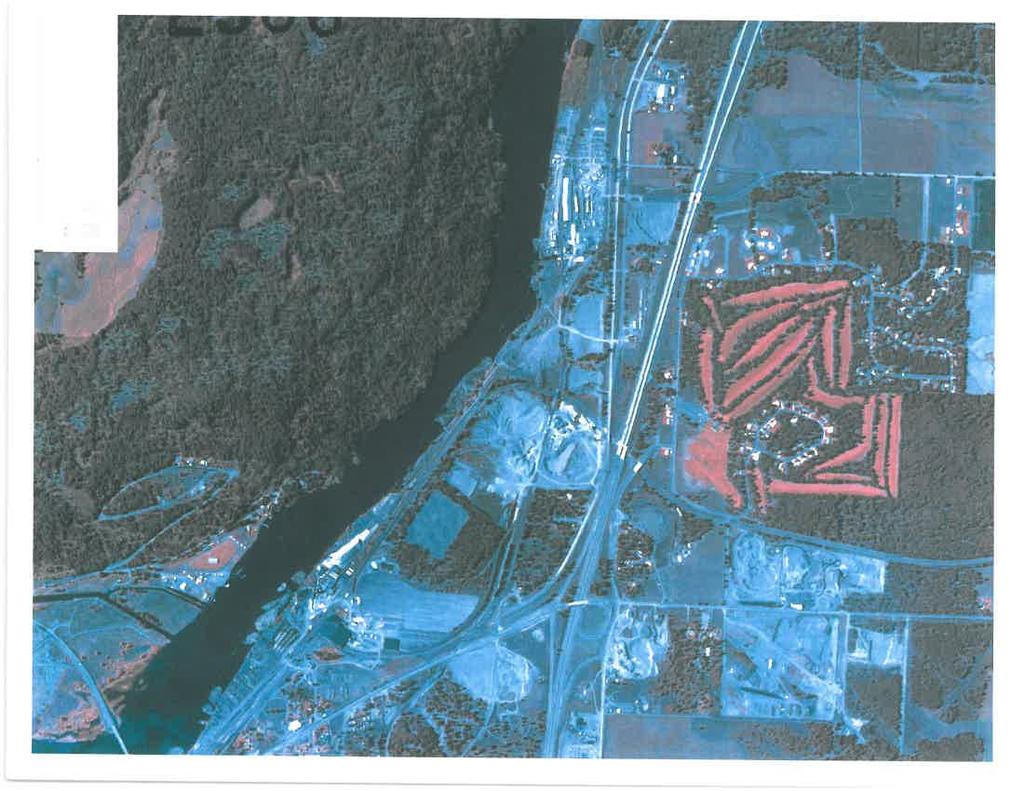
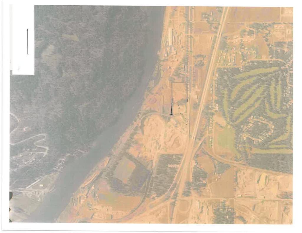
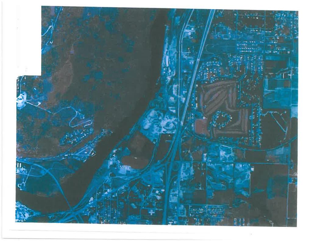
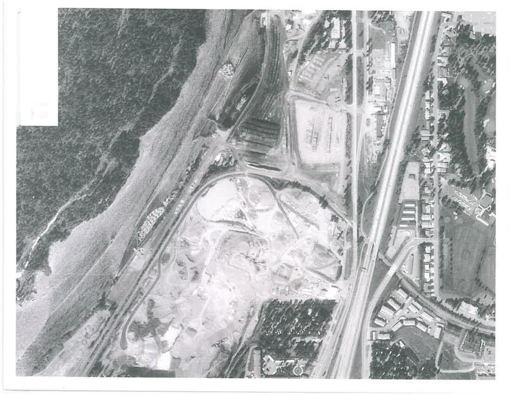
5 Geotechnical Evaluation ALLWEST Project No G Stimson Mill Site Page 2 Coeur d Alene, Idaho 7) Prepared this report. Our services were provided in general accordance with our proposal P , dated April 1, PROJECT DESCRIPTION We understand the project includes the redevelopment of the Stimson Mill Site at the above referenced location which includes approximately 38 acres on parcels 50N04W and 50N04W The preliminary plan for the proposed development includes single family residential, multi-family condominiums, commercial lots and park space. This evaluation was limited to the northeast portion of the site with an area of approximately 14 acres which is underlain by mill waste materials and uncontrolled fill. A final grading plan was not available at the time this report was prepared. However, we anticipate excavation and removal of the waste and uncontrolled fill and placement of compaction to proposed final grades to create suitable building sites for future development. Preliminary conceptual plans indicate a proposed commercial parcel on the western half (approximately 5 acres) of the site and proposed park space and possible baseball/softball stadium located on the eastern half (approximately 9 acres) of the site. 3.0 EVALUATION PROCEDURES To complete this evaluation, we reviewed soil and geologic literature for the project area. We also reviewed the documents referenced in Section 1.0 of this report. We conducted a field evaluation of the property including a site reconnaissance to assist in planning the field evaluation and provide a general overview of the property. Information obtained from the field evaluation, review of the referenced documents, laboratory testing and geotechnical analysis were utilized to develop recommendations for the geotechnical aspects of the project. 4.0 SITE CONDITIONS The project is located in the northwest ¼ of Section 10, Township 50 North, Range 4 West of the Boise Meridian. The site was previously used as a lumber mill. The northeast portion of the site contains stockpiles of topsoil, cobbles and other various materials. The site slopes down gently to moderately to the south towards the Spokane River. The site is currently vacant but remnants of previous structures, excavations, railways and other previous site features are present across the site. The site is bordered by Seltice Way to the north, the Spokane River to the south, the Riverstone development to the east and vacant property to the west. Aerial images reviewed for the project site indicate a gravel pit on the east side of the site between
6 Geotechnical Evaluation ALLWEST Project No G Stimson Mill Site Page 3 Coeur d Alene, Idaho 1971 and The next aerial image available is from 1998 which shows the gravel pit backfilled creating a relatively level site being used for log storage. 4.1 GENERAL GEOLOGIC CONDITIONS The geologic conditions on the property were mapped on the Geologic Map of the Coeur d Alene 30 x 60 Minute Quadrangle, Idaho by Lewis, et al, The mapping indicates the geology is Channel gravel, undivided. The deposit consists of the latest Wisconsin catastrophic flood and outwash gravel and sand deposited in channelways cut into high energy fans and bars of Glacial Lake Missoula flood origin. The native soils observed in the borings and test pits are generally consistent with the geologic mapping. 4.2 GENERAL SOIL CONDITIONS The USDA Natural Resources Conservation Service has mapped the soils on and around the property as McGuire-Marble association. The McGuire soils are very deep, excessively drained and formed from glacial outwash materials. The permeability of this soil is moderately rapid and the water erosion hazard is slight. The Marble soils are very deep, excessively drained and formed in wind and waterworked sandy outwash materials. The permeability of this soil is rapid and the water erosion hazard is slight. The run-off is slow. The typical soil profile for both of these soils is very gravelly coarse sand to loamy sand. The native soils encountered in the borings and test pits are generally more consistent with the geologic mapping than the SCS mapping. 4.3 HYDROGEOLOGIC CONDITIONS The project site is underlain by the Rathdrum Prairie aquifer. We did not encounter groundwater during our site evaluation. We did not observe surface water on the property. We do not anticipate excavations for the proposed project will encounter groundwater. However, changes in precipitation, irrigation, construction or other factors may impact depth to groundwater and the surface water flow on the property. Well logs in the vicinity of the project report static groundwater depths approximately 100 feet or greater below ground surface. 5.0 SUBSURFACE CONDITIONS Three (3) borings were drilled and eight (8) test pits were excavated at the site at the approximate locations shown on the Boring and Test Pit Location Map, Figure A-2, in Appendix A of this report. The locations of the borings and test pits were selected based on historical aerial photography and future development planned. The borings were drilled with a truck mounted drill rig owned and operated by Haz-Tech Drilling. The test pits were excavated with a track mounted excavator owned and operated by Alamo Excavating. The soil conditions observed in the borings and test pits were visually described and classified in general accordance with ASTM D 2487 and D
7 Geotechnical Evaluation ALLWEST Project No G Stimson Mill Site Page 4 Coeur d Alene, Idaho 2488 and the subsurface profiles were logged. Disturbed SPT samples and bulk samples were obtained from the borings and test pits. 5.1 SUBSURFACE SOIL CONDITIONS The subsurface soil profile observed in the borings and test pits generally consisted of varying depths of uncontrolled fill up to approximately 60 feet below the ground surface underlain by natural poorly-graded sand with gravel. Descriptions of the soil types observed follow: Uncontrolled fill The uncontrolled fill generally consisted of silty sand and gravel mixed with organics, crushed concrete, cobbles, wood waste. The color, consistency, moisture and depth of the fill varied widely across the northeast portion of the site. Areas of wood waste were encountered which consisted of little to no soil. The presence and consistency of fill is anticipated to vary between boring and test pit locations. Silty sand with gravel The silty sand with gravel appeared loose, dry and gray. Cobbles and boulders were observed up to 36 inches in diameter. The gravel and cobbles observed were sub-rounded to rounded. Well-graded sand with silt and gravel The well-graded sand with silt and gravel appeared loose to dense, moist, and gray to brown in color. The gravel and cobbles observed were rounded. Poorly-graded gravel with silt and sand The poorly-graded gravel with silt and sand appeared medium dense to very dense, dry, and gray blue-green in color. The gravel and cobbles observed were subangular to rounded 5.2 GROUNDWATER CONDITIONS Groundwater was not observed in the boring or test pits at the time of the field evaluation. Changes in precipitation, construction or other factors may impact the depth to groundwater on the property. Fluctuations in the groundwater level should be expected. Detailed descriptions of the soil observed in the borings are presented on the Boring and Test Pit Logs in Appendix B of this report. The descriptive soil terms used on the boring logs and in this report can be referenced by the Unified Soil Classification System (USCS). A copy of the USCS is included in Appendix B. The subsurface conditions may vary between boring locations. Such changes in conditions would not be apparent until construction. If the subsurface conditions do change from those observed in the borings, the construction timing, plans and costs may change.
8 Geotechnical Evaluation ALLWEST Project No G Stimson Mill Site Page 5 Coeur d Alene, Idaho 6.0 LABORATORY TESTING Laboratory testing was performed to supplement field classifications and to assess some of the soil engineering parameters. The laboratory tests conducted included inplace water content (ASTM D 2216) and gradation (ASTM D 422 and ASTM D 1140). The laboratory test results are summarized in Table C-1 in Appendix C. The laboratory test results are also summarized on the boring and test pit logs in Appendix B. The laboratory testing was performed by ALLWEST. 7.0 CONCLUSIONS AND RECOMMENDATIONS It is our opinion the site is suitable for the proposed development provided the recommendations in this report are followed and the potential associated risks are acceptable to the owner. The existing uncontrolled fill, which extends to depths of up to approximately 62 feet below the existing grade, is unsuitable in its current condition to support the proposed development. The following recommendations are presented to assist the planning and design of the proposed development. The recommendations are based on our understanding of the proposed development, the conditions observed in the borings and test pits, laboratory test results and geotechnical analysis. If the scope of the construction changes, or if conditions are encountered during construction which are different than those described in this report, we should be notified so we can review our recommendations and provide revisions if necessary. 7.1 PLANNING CONSIDERATIONS The subsurface conditions observed in the borings and test pits indicate uncontrolled fill generally extends to a maximum depth of approximately 62 feet below the existing grade in the vicinity of the stockpiles in the northeast corner of the site. The depth of uncontrolled fill observed in the boring and test pits decreases near the perimeter of the northeast portion of the site. The approximate limits of the uncontrolled fill are shown on the Boring and Test Pit Location Map, Figure A-2, in Appendix A of this report. The uncontrolled fill is unsuitable for support structural improvements such as buildings, asphalt, concrete, retaining walls or similar improvements. Uncontrolled fill presents the risk of post construction settlement of the proposed structures and pavement if it remains in place. Ideally, the uncontrolled fill would be removed its full depth below building and pavement areas and replaced with properly compacted structural fill. Due to the size of the site and significant depth of the fill, we understand this may not be practical and will likely be cost prohibitive in pavement areas. However, the full depth of fill in the proposed building areas should be overexcavated below foundations and slabs and replaced with structural fill in properly compacted lifts. The following table provides the depth of uncontrolled fill observed in each boring or test pit location:
9 Geotechnical Evaluation ALLWEST Project No G Stimson Mill Site Page 6 Coeur d Alene, Idaho Location Depth B-1 15 ft B-2 20 ft B-3 62 ft TP-1 0 ft TP ft* TP ft* TP-4 17 ft TP-5 3 ft TP-6 8 ft TP-7 6 ft TP-8 0 ft *Natural soil not encountered to the maximum depth excavated in the test pit 7.2 SITE PREPARATION Building Pads Prior to conducting site grading, vegetation, deleterious material, disturbed soil, soil containing significant amounts of roots and organics and uncontrolled fill should be removed its entire depth below proposed building, slabs and flatwork areas. Based on the subsurface conditions observed in the borings and test pits, we anticipate this may require the removal of up to approximately 62 feet of uncontrolled fill. Building type and locations were not identified at the time this report was prepared. The excavation area of uncontrolled fill should be oversized using a 1:1 (horizontal to vertical) slope from the edge of the building area, for example a 10 foot deep excavation of uncontrolled fill should be widened by 10 feet beyond the anticipated area of the building. Alternatively, deep foundations such as rammed aggregate piers, driven piles, micro-piles, helical anchors or similar which extend through the uncontrolled fill into natural soil may be used to support building foundations. The proposed building plans and loading would be required to provide recommendations for deep foundations under a separate scope of services. Significant amounts of organic material and mill waste (bark and wood chips) were observed in the borings and test pits. If landscape and/or parking areas are to be located over areas where the organic material is present there is potential for total and differential settlement. Additional maintenance should be anticipated in areas of landscaping and/or pavement where organics are left in place. Prior to placing fill, the exposed subgrade should be scarified to a depth of eight (8) inches; properly moisture conditioned and compacted to at least 90 percent of the maximum dry density as determined by ASTM D1557. Compaction of the subgrade may be reduced to proof rolling at the discretion of the geotechnical engineer based on conditions. If the subgrade is observed to significantly deflect it should be overexcavated to firm, non-yielding soil and replaced with properly compacted fill.
10 Geotechnical Evaluation ALLWEST Project No G Stimson Mill Site Page 7 Coeur d Alene, Idaho Pavement Areas We recommend the uncontrolled fill and organic material be excavated and removed its full depth beneath proposed driveway and parking areas and replaced with properly compacted fill. We anticipate the removal of the full depth of the uncontrolled fill and organic material could be cost prohibitive. We recommend the uncontrolled fill in the area of the proposed commercial parcel on the western portion of the site be excavated and removed in its entirety and replaced with properly compacted fill. This precaution will provide a commercial property with the most options for development in the future. If Abundant Land Partners, LLC is willing to accept the risk of potential postconstruction settlement of the pavement areas located on the eastern portion of the site, consideration may be given to removal of a portion of the existing uncontrolled fill. The thickness of the uncontrolled fill observed was up to approximately 62 feet below existing grades. Due to the variable nature of uncontrolled fill and the presence of the organics, it is difficult to reasonably estimate the magnitude of the settlement which may occur over the life of the pavement. Based on settlement observed in the existing pavement at the site, settlement of up to and possibly exceeding one (1) foot may be anticipated. 7.3 EXCAVATION Excavation of the on-site soil can be conducted with typical excavation equipment. We recommend excavations greater than four (4) feet deep be sloped no steeper than 1.5:1 (horizontal to vertical). Alternatively, deeper excavations may be shored or braced in accordance with OSHA specifications and local codes. Regarding trench wall support, the site soil is considered Type C soil according to Occupational Safety and Health Administration (OSHA) guidelines. The contractor is responsible to provide appropriate trench wall support and/or sloping. Dewatering Excavations which extend below the groundwater elevation will require dewatering. The method of dewatering should be selected by the contractor, if necessary. Materials The on-site granular soil (sand and gravel) is generally suitable for use as structural fill, site grading fill and utility trench backfill provided it is free of deleterious material and material larger than four (4) inches in size. Import materials should be granular soil free of organics, debris and other deleterious material and meet the following recommendations. Import materials should be approved by the Geotechnical Engineer prior to delivery to the site.
11 Geotechnical Evaluation ALLWEST Project No G Stimson Mill Site Page 8 Coeur d Alene, Idaho Fill Type Structural Fill Site Grading Utility Trench Backfill Recommendations Maximum size 3 inches; Passing No. 200 Sieve 15%; Non-plastic Maximum size 3 inches; Passing No. 200 Sieve 35%; Liquid Limit 35% Maximum size 2 inches; Passing No. 200 Sieve 15%; Non-plastic 7.4 FILL PLACEMENT AND COMPACTION Fill should be placed in lift thicknesses which are appropriate for the compaction equipment used. Typically, eight (8) inch loose lifts are appropriate for typical rubber tire and steel drum compaction equipment. Lift thicknesses should be reduced to four (4) inches for hand operated compaction equipment. Fill should be moisture conditioned to within two (2) percentage points of the optimum moisture content prior to placement to facilitate compaction. In wet weather or spring conditions, using silty or fine-grained soil for fill may delay construction and increase costs. Fill should be compacted to the following percentages of the maximum dry density as determined by ASTM D Compaction Fill Area (%) Subgrade 90* Site Grading / Pavement 95 Building Pad 95 Foundations / Slabs 95 Utility Trench Backfill 95 Base Course 95 *May be reduced to proof roll at the discretion of the geotechnical engineer. The following recommendations are provided for placement of fill materials which are not testable due to high gravel content. The structural fill should be placed in maximum 12 inch thick lifts with a minimum 10-ton vibratory compactor. The compactor should impart a minimum dynamic force of 30,000 pounds of impact per vibration with a minimum of 1,000 vibrations per minute. These recommendations are based on Washington Department of Transportation Standard Specifications for placement of rock fill. A minimum of four (4), full coverage passes should be made for each six (6) inches of lift thickness.
12 Geotechnical Evaluation ALLWEST Project No G Stimson Mill Site Page 9 Coeur d Alene, Idaho Fill materials which are not testable due to high gravel content may require full time observation by a representative of ALLWEST during placement. 7.5 WET WEATHER CONSTRUCTION We recommend earthwork for this site be scheduled for the drier seasons of the year. If construction is undertaken in wet periods of the year, it will be important to slope the ground surface to provide drainage away from construction. 7.6 COLD WEATHER CONSTRUCTION The near surface soils encountered in the borings and test pits are considered to be frost susceptible. If site grading and construction are anticipated during cold weather, we recommend good winter construction practices be observed. Snow and ice should be removed from excavated and fill areas prior to additional earthwork or construction. Footings, floors slabs or any structural portions of the construction should not be placed on frozen ground; nor should the supporting soils for buildings be permitted to freeze during or after construction. Frozen soils should not be used as backfill or fill. 7.7 FOUNDATION RECOMMENDATIONS Specific building locations and building types were not available at the time this report was prepared. We understand the future building locations will be in areas where it is practical to remove the organic and uncontrolled fill and replace with properly placed and compacted structural fill. We recommend site specific geotechnical evaluations be completed for the future building locations. If future buildings are located over areas where organic and/or uncontrolled fill remain in the subsurface, there is potential for total and differential settlement. Alternatively, future buildings may utilize deep foundations which bear in natural, undisturbed soil. 7.8 PAVEMENT RECOMMENDATIONS We understand the site may contain asphalt pavement driveways and parking areas. We anticipate a minor amount of rigid (concrete) pavement may also be constructed at the proposed commercial parcel. Site specific recommendations for pavement should be provided based on the estimated traffic loads and site layout. If pavement is to be located over uncontrolled fill and organic material, we recommend using a geogrid reinforced pavement section to help reduce differential settlement. Total and differential settlement should still be anticipated if geogrid is used as reinforcement in the pavement section. 7.9 STORM WATER AND DRAINAGE We anticipate storm water runoff will be contained on-site and directed to infiltration swales. It is our opinion the site will be suitable for the use of drywells. wells should be keyed into natural soil or structural fill and not located in areas where organics and/or uncontrolled fill exists. We recommend the grading plan include
13 Geotechnical Evaluation ALLWEST Project No G Stimson Mill Site Page 10 Coeur d Alene, Idaho slopes such that storm water run-off is directed away from the building, flatwork and pavement areas EROSION CONTROL Erosion control measures such as sediment ponds, silt fences, wattles and/or water bars may be necessary if construction occurs during periods of heavy precipitation in the winter and spring months. The exposed natural soils will be susceptible to gullying and erosion. Minor areas of sloughing may be anticipated on constructed slopes until vegetation is established. We recommend constructed slopes be maintained through removal of sloughed materials and re-seeding these areas. Areas disturbed during construction should be re-vegetated as soon as practical. We recommend a storm water pollution prevention plan (SWPPP) be prepared for this site prior to earthwork. 8.0 ADDITIONAL RECOMMENDED SERVICES We recommend ALLWEST Testing & Engineering, LLC be retained to provide construction monitoring and testing to verify the soil and geologic conditions and the report recommendations are incorporated into the actual construction. Observe removal of uncontrolled fill prior to site grading. Observe and test compaction of the subgrade prior to placement of fill. Conduct frequent compaction testing of fill placed. Conduct frequent compaction testing of concrete and pavement materials, if necessary. If we are not retained to provide the recommended plan review and construction monitoring services, we cannot be responsible for soil engineering related construction errors or omissions. 9.0 EVALUATION LIMITATIONS This report has been prepared to assist the planning and design of the proposed development of the Stimson Mill Site located at 3074 W. Seltice Way in Coeur d Alene, Idaho. Our services consist of professional opinions and conclusions made in accordance with generally accepted geotechnical engineering principles and practices. This acknowledgement is in lieu of all warranties either expressed or implied. The following plates complete this report: Appendix A Vicinity Map, Boring and Test Pit Location Map
14 Geotechnical Evaluation ALLWEST Project No G Stimson Mill Site Page 11 Coeur d Alene, Idaho Appendix B Boring and Test Pit Logs, Unified Soil Classification System Appendix C Laboratory Test Results Appendix D Aerial Images
15 Geotechnical Evaluation Stimson Mill Site Coeur d Alene, Idaho Project No G Appendix A Vicinity Map Boring and Test Pit Location Map

16 PROJECT SITE USGS 7.5 MINUTE SERIES TOPOGRAPHIC MAP COEUR D ALENE QUADRANGLE, IDAHO 2013 DIAGRAM IS FOR GENERAL LOCATION ONLY, AND IS NOT INTENDED FOR CONSTRUCTION PURPOSES W N S E Hayden, Idaho FIGURE A-1: VICINITY MAP Stimson Mill Site 3074 W. Seltice Way Coeur d Alene, Idaho Client Name: Abundant Land Partners LLC Project No.: G Date:: May 7, 2014


17 TP-1 B-1 B-2 TP-2 TP-3 APPROXIMATE LIMITS OF UNDOCUMENTED FILL TP-5 TP-4 B-3 TP-6 TP-7 TP-8 REFERENCE: USGS TEST PIT LOCATIONS ARE APPROXIMATE DIAGRAM IS FOR GENERAL LOCATION ONLY, AND IS NOT INTENDED FOR CONSTRUCTION PURPOSES W N S E Hayden, Idaho FIGURE A-2: BORING & TEST PIT LOCATION MAP Stimson Mill Site W. Seltice Way Coeur d Alene, Idaho Client Name: Abundant Land Partners, LLC Project No.: G Date:: May 8, 2014
18 Geotechnical Evaluation Stimson Mill Site Coeur d Alene, Idaho Project No G Appendix B Boring and Test Pit Logs Unified Soil Classification System
19 ALLWEST TESTING & ENGINEERING, LLC. HAYDEN, IDAHO GEOTECHNICAL SECTION PROJECT: Stimson Mill Site BORING LOG DATE STARTED: 4/8/2014 DATE FINISHED: 4/8/2014 DRILLER: Jarod Willard COMPANY: Haztech ENGINEER: Sean Brady WEATHER: Sunny, 60's NOTES: BORING B-1 DRILL: B-81 HAMMER: Automatic DRILLING METHODS: 8" Hollow Stem Auger STATION, OFFSET: LATITUDE (DEGREES): N 47 42'0.63" ( ) LONGITUDE (DEGREES): W ' " ( ) USCS FILL TOTAL DEPTH: 51.5' DESCRIPTION ASPHALT; good condition, black. UNCONTROLLED FILL; silty gravel with sand; organics, appeared moderately compacted, brown, dry to moist. GRAPHIC LOG SAMPLE # SAMPLER FIELD BLOW COUNT (Recovery) 0 WATER CONTENT (%) PLASTIC LIMIT LIQUID LIMIT FIELD "N" VALUE UNCONTROLLED FILL; silty sand with gravel mixed with wood shavings/chips; poorly compacted, black, moist to wet. B-1@ (9" = 50%) 5.5 FILL B-1@ (10" = 56%) Well-graded SAND with silt and gravel; medium dense to dense, gray, dry. B-1@ (10" = 56%) 16.5 B-1@ (11" = 61%) 22.0 SW-SM B-1@ (13" = 72%) 27.5 Lens of fine grained sand, orange, moist to wet. B-1@ (15" = 83%) 33.0 Gravel layer. B-1@ (17" = 94%) Poorly-graded GRAVEL with silt and sand; subangular to rounded gravel, dense, gray, dry. B-1@ (14" = 78%) 44.0 GP-GM B-1@ (12" = 67%) Bottom of boring B-1 at approximately 51 1/2 feet below ground surface. No ground water encountered. B-1@ (12" = 67%) WATER LEVELS WHILE DRILLING AT COMPLETION AFTER DRILLING Hollow Stem Auger 2" OD Split Spoon (SPT) Sheet 1 of 1
20 ALLWEST TESTING & ENGINEERING, LLC. HAYDEN, IDAHO GEOTECHNICAL SECTION PROJECT: Stimson Mill Site BORING LOG DATE STARTED: 4/8/2014 DATE FINISHED: 4/8/2014 DRILLER: Jarod Willard COMPANY: Haztech ENGINEER: Sean Brady WEATHER: Sunny, 60's NOTES: BORING B-2 DRILL: B-81 HAMMER: Automatic DRILLING METHODS: 8" Hollow Stem Auger STATION, OFFSET: LATITUDE (DEGREES): N 47 42'0.1764" ( ) LONGITUDE (DEGREES): W ' " ( ) USCS FILL TOTAL DEPTH: 51.5' DESCRIPTION ASPHALT; good condition, black. UNCONTROLLED FILL; silty gravel; organics, appeared moderately compacted, brown, dry to moist. GRAPHIC LOG SAMPLE # SAMPLER FIELD BLOW COUNT (Recovery) 0 WATER CONTENT (%) PLASTIC LIMIT LIQUID LIMIT FIELD "N" VALUE UNCONTROLLED FILL; wood shavings/chips; poorly compacted, orange, moist. B-2@ (11" = 61%) 5.5 B-2@ (6" = 33%) 11.0 FILL B-2@ (7" = 39%) Poorly-graded GRAVEL with silt and sand; subangular to rounded gravel, dense to very dense, gray, dry. B-2@ (16" = 89%) 22.0 B-2@ (14" = 78%) >> 27.5 B-2@ (12" = 67%) >> 33.0 GP-GM B-2@ (9" = 50%) >> 38.5 B-2@40 50/2" (0" = 0%) 44.0 B-2@ (13" = 72%) Bottom of boring B-2 at approximately 51 1/2 feet below ground surface. No ground water encountered. B-2@ (15" = 83%) WATER LEVELS WHILE DRILLING AT COMPLETION AFTER DRILLING Hollow Stem Auger 2" OD Split Spoon (SPT) Sheet 1 of 1
21 ALLWEST TESTING & ENGINEERING, LLC. HAYDEN, IDAHO GEOTECHNICAL SECTION PROJECT: Stimson Mill Site BORING LOG DATE STARTED: 4/8/2014 DATE FINISHED: 4/8/2014 DRILLER: Jarod Willard COMPANY: Haztech ENGINEER: Sean Brady WEATHER: Sunny, 60's NOTES: BORING B-3 DRILL: B-81 HAMMER: Automatic DRILLING METHODS: 8" Hollow Stem Auger STATION, OFFSET: LATITUDE (DEGREES): N 47 41' " ( ) LONGITUDE (DEGREES): W '5.8188" ( ) 0.0 USCS TOTAL DEPTH: 101.5' DESCRIPTION UNCONTROLLED FILL; silty gravel with sand; organics, moderately compacted, dark brown, moist. GRAPHIC LOG SAMPLE # SAMPLER FIELD BLOW COUNT (Recovery) 0 WATER CONTENT (%) PLASTIC LIMIT LIQUID LIMIT FIELD "N" VALUE FILL B-3@ (14" = 78%) 5.5 B-3@ (0" = 0%) UNCONTROLLED FILL; silty sand with gravel mixed with wood shavings/chips; poorly compacted, dark brown to black, moist to wet. B-3@ (6" = 33%) 16.5 B-3@ (9" = 50%) 22.0 B-3@ (12" = 67%) 27.5 Seeps. B-3@ (12" = 67%) 33.0 B-3@ (9" = 50%) 38.5 FILL B-3@ (16" = 89%) 44.0 B-3@ (3" = 17%) 49.5 B-3@ (16" = 89%) WATER LEVELS WHILE DRILLING AT COMPLETION AFTER DRILLING Hollow Stem Auger 2" OD Split Spoon (SPT) Sheet 1 of 2
22 ALLWEST TESTING & ENGINEERING, LLC. HAYDEN, IDAHO GEOTECHNICAL SECTION PROJECT: Stimson Mill Site BORING LOG DATE STARTED: 4/8/2014 DATE FINISHED: 4/8/2014 DRILLER: Jarod Willard COMPANY: Haztech ENGINEER: Sean Brady WEATHER: Sunny, 60's NOTES: BORING B-3 DRILL: B-81 HAMMER: Automatic DRILLING METHODS: 8" Hollow Stem Auger STATION, OFFSET: LATITUDE (DEGREES): N 47 41' " ( ) LONGITUDE (DEGREES): W '5.8188" ( ) USCS TOTAL DEPTH: 101.5' DESCRIPTION GRAPHIC LOG SAMPLE # B-3@55 SAMPLER FIELD BLOW COUNT (Recovery) (14" = 78%) 0 WATER CONTENT (%) PLASTIC LIMIT LIQUID LIMIT FIELD "N" VALUE Gravel layer. B-3@ (14" = 78%) Poorly-graded GRAVEL with silt and sand; subangular to rounded gravel, dense to very dense, gray, dry to moist. B-3@ (9" = 50%) 66.0 B-3@ (9" = 50%) 71.5 B-3@ (8" = 44%) 77.0 GP-GM B-3@ (11" = 61%) >> 82.5 B-3@ (18" = 100%) 88.0 B-3@ (16" = 89%) 93.5 B-3@ (14" = 78%) >> Bottom of boring B-3 at approximately 101 1/2 feet below ground surface. No ground water encountered. B-3@ (12" = 67%) WATER LEVELS WHILE DRILLING AT COMPLETION AFTER DRILLING Hollow Stem Auger 2" OD Split Spoon (SPT) Sheet 2 of 2
23 ALLWEST TESTING & ENGINEERING, LLC. HAYDEN, IDAHO GEOTECHNICAL SECTION PROJECT: Stimson Mill Site TEST PIT LOG DATE STARTED: 4/16/2014 DATE FINISHED: 4/16/2014 OPERATOR: Casey COMPANY: Alamo Excavting ENGINEER: Sean Brady WEATHER: Raining, 50's NOTES: TEST PIT TP-1 EXCAVATOR: John Deere 120C EXCAVATION METHOD: Soil Excavation Bucket STATION, OFFSET: 0.0 USCS TOTAL DEPTH: 6' DESCRIPTION TOPSOIL; silty sand with gravel; appeared loose, dark brown, moist. Surface organics and roots observed throughout. GRAPHIC LOG NOTES TOPSOIL 1.0 Well-graded SAND with silt and gravel; appeared loose to medium dense, brown, moist. Caving of sidewalls. 1.0 SW-SM SAMPLE # Bottom of test pit TP-1 at approximately 6 feet below ground surface. No ground water encountered. 6.0 WATER LEVELS WHILE EXCAVATING AT COMPLETION AFTER EXCAVATING Sheet 1 of 1
24 ALLWEST TESTING & ENGINEERING, LLC. HAYDEN, IDAHO GEOTECHNICAL SECTION PROJECT: Stimson Mill Site TEST PIT LOG DATE STARTED: 4/16/2014 DATE FINISHED: 4/16/2014 OPERATOR: Casey COMPANY: Alamo Excavting ENGINEER: Sean Brady WEATHER: Raining, 50's NOTES: TEST PIT TP-2 EXCAVATOR: John Deere 120C EXCAVATION METHOD: Soil Excavation Bucket STATION, OFFSET: 0.0 USCS FILL TOTAL DEPTH: 17' DESCRIPTION UNCONTROLLED FILL; silty gravel with sand; organics, appeared moderately compacted, black to gray, moist. Angular to subrounded cobbles and boulders up to 18 inches observed. GRAPHIC LOG NOTES 2.0 Geotextile Fabric. UNCONTROLLED FILL; silty sand with gravel; organics, appeared poorly compacted, black, moist. 2.0 FILL 5.0 UNCONTROLLED FILL; wood shavings/chips; appeared poorly compacted, orange, moist. 5.0 WOOD SAMPLE # Bottom of test pit TP-2 at approximately 17 feet below ground surface. No ground water encountered WATER LEVELS WHILE EXCAVATING AT COMPLETION AFTER EXCAVATING Sheet 1 of 1
25 ALLWEST TESTING & ENGINEERING, LLC. HAYDEN, IDAHO GEOTECHNICAL SECTION PROJECT: Stimson Mill Site TEST PIT LOG DATE STARTED: 4/16/2014 DATE FINISHED: 4/16/2014 OPERATOR: Casey COMPANY: Alamo Excavting ENGINEER: Sean Brady WEATHER: Raining, 50's NOTES: TEST PIT TP-3 EXCAVATOR: John Deere 120C EXCAVATION METHOD: Soil Excavation Bucket STATION, OFFSET: 0.0 USCS TOTAL DEPTH: 12' DESCRIPTION ASPHALT; good condition, black. GRAPHIC LOG NOTES 0.7 UNCONTROLLED FILL; silty gravel with sand; appeared moderately compacted, brown, dry to moist. 0.7 FILL 2.0 Geotextile Fabric. UNCONTROLLED FILL; silty sand with gravel; organics, appeared poorly compacted, black, moist. 2.0 FILL 4.0 UNCONTROLLED FILL; wood shavings/chips; appeared poorly compacted, brown, moist. 4.0 WOOD SAMPLE # Bottom of test pit TP-3 at approximately 12 feet below ground surface. No ground water encountered WATER LEVELS WHILE EXCAVATING AT COMPLETION AFTER EXCAVATING Sheet 1 of 1
26 ALLWEST TESTING & ENGINEERING, LLC. HAYDEN, IDAHO GEOTECHNICAL SECTION PROJECT: Stimson Mill Site TEST PIT LOG DATE STARTED: 4/16/2014 DATE FINISHED: 4/16/2014 OPERATOR: Casey COMPANY: Alamo Excavting ENGINEER: Sean Brady WEATHER: Raining, 50's NOTES: TEST PIT TP-4 EXCAVATOR: John Deere 120C EXCAVATION METHOD: Soil Excavation Bucket STATION, OFFSET: 0.0 USCS TOTAL DEPTH: 18' DESCRIPTION UNCONTROLLED FILL; silty gravel with sand and organics; appeared poorly to moderately compacted, black, moist. Sub-angular to sub-rounded cobbles and boulders up to 24 inches observed. GRAPHIC LOG NOTES FILL 3.0 UNCONTROLLED FILL; wood shavings/chips; appeared poorly compacted, orange, moist. 3.0 WOOD 8.0 UNCONTROLLED FILL; silty gravel with sand; organics, appeared poorly compacted, black, moist. 8.0 FILL SAMPLE # GP-GM Poorly-graded GRAVEL with silt and sand; appeared medium dense, blue/green, moist. Rounded cobbles up to 3 inches observed. Bottom of test pit TP-4 at approximately 18 feet below ground surface. No ground water encountered. S % retained on #4 sieve 5.3% passing #200 sieve 5.5% moisture content WATER LEVELS WHILE EXCAVATING AT COMPLETION AFTER EXCAVATING Sheet 1 of 1
27 ALLWEST TESTING & ENGINEERING, LLC. HAYDEN, IDAHO GEOTECHNICAL SECTION PROJECT: Stimson Mill Site TEST PIT LOG DATE STARTED: 4/16/2014 DATE FINISHED: 4/16/2014 OPERATOR: Casey COMPANY: Alamo Excavting ENGINEER: Sean Brady WEATHER: Raining, 50's NOTES: TEST PIT TP-5 EXCAVATOR: John Deere 120C EXCAVATION METHOD: Soil Excavation Bucket STATION, OFFSET: 0.0 USCS TOTAL DEPTH: 10' DESCRIPTION UNCONTROLLED FILL; silty sand with gravel; organics, appeared poorly compacted, black, moist. GRAPHIC LOG SAMPLE # NOTES FILL FILL GP-GM UNCONTROLLED FILL; silty sand with gravel; appeared moderately compacted, brown, dry to moist. Poorly-graded GRAVEL with silt and sand; appeared medium dense, blue/green, moist. Well-graded SAND with silt and gravel; appeared loose to medium dense, brown, moist. Rounded cobbles and boulders up to 24 inches observed Caving of sidewalls. SW-SM S % retained on #4 sieve 6.8% passing #200 sieve 6.8% moisture content 10.0 Bottom of test pit TP-5 at approximately 10 feet below ground surface. No ground water encountered WATER LEVELS WHILE EXCAVATING AT COMPLETION AFTER EXCAVATING Sheet 1 of 1
28 ALLWEST TESTING & ENGINEERING, LLC. HAYDEN, IDAHO GEOTECHNICAL SECTION PROJECT: Stimson Mill Site TEST PIT LOG DATE STARTED: 4/16/2014 DATE FINISHED: 4/16/2014 OPERATOR: Casey COMPANY: Alamo Excavting ENGINEER: Sean Brady WEATHER: Raining, 50's NOTES: TEST PIT TP-6 EXCAVATOR: John Deere 120C EXCAVATION METHOD: Soil Excavation Bucket STATION, OFFSET: 0.0 USCS TOTAL DEPTH: 8.5' DESCRIPTION UNCONTROLLED FILL; silty gravel with sand; organics, appeared poorly to moderately compacted, brown, dry to moist. Cobbles and boulders up to 36 inches and mill waste observed throughout. GRAPHIC LOG SAMPLE # NOTES FILL 4.0 UNCONTROLLED FILL; silty sand with gravel; organics, appeared moderately compacted, blue/green, moist. Cobbles and boulders up to 10 inches observed throughout. 4.0 FILL WOOD UNCONTROLLED FILL; wood shavings/chips; appeared poorly compacted, dark brown, moist Silty SAND with gravel; appeared medium dense, brown, moist SM Test pit terminated at approximately 8 1/2 feet below ground surface due to confined location. No ground water encountered. 8.5 WATER LEVELS WHILE EXCAVATING AT COMPLETION AFTER EXCAVATING Sheet 1 of 1
29 ALLWEST TESTING & ENGINEERING, LLC. HAYDEN, IDAHO GEOTECHNICAL SECTION PROJECT: Stimson Mill Site TEST PIT LOG DATE STARTED: 4/16/2014 DATE FINISHED: 4/16/2014 OPERATOR: Casey COMPANY: Alamo Excavting ENGINEER: Sean Brady WEATHER: Raining, 50's NOTES: TEST PIT TP-7 EXCAVATOR: John Deere 120C EXCAVATION METHOD: Soil Excavation Bucket STATION, OFFSET: 0.0 USCS TOTAL DEPTH: 12' DESCRIPTION UNCONTROLLED FILL; silty sand with gravel; organics, appeared poorly compacted, black, moist. GRAPHIC LOG NOTES FILL 2.0 Geotextile Fabric UNCONTROLLED FILL; silty gravel with sand; organics, appeared moderately compacted, gray, moist. Sub-rounded to rounded cobbles and boulders up to 24 inches. Trash and organics observed throughout. 2.0 FILL 4 Bulk sample obtained. 6.0 Well-graded SAND with silt and gravel; appeared loose, gray to brown, moist. Caving of sidewalls. 6.0 SW-SM SAMPLE # Bottom of test pit TP-7 at approximately 12 feet below ground surface. No ground water encountered WATER LEVELS WHILE EXCAVATING AT COMPLETION AFTER EXCAVATING Sheet 1 of 1
30 ALLWEST TESTING & ENGINEERING, LLC. HAYDEN, IDAHO GEOTECHNICAL SECTION PROJECT: Stimson Mill Site TEST PIT LOG DATE STARTED: 4/16/2014 DATE FINISHED: 4/16/2014 OPERATOR: Casey COMPANY: Alamo Excavting ENGINEER: Sean Brady WEATHER: Raining, 50's NOTES: TEST PIT TP-8 EXCAVATOR: John Deere 120C EXCAVATION METHOD: Soil Excavation Bucket STATION, OFFSET: 0.0 USCS TOTAL DEPTH: 7' DESCRIPTION TOPSOIL; silty sand with gravel; appeared loose, brown, dry to moist. Surface organics and roots observed throughout. GRAPHIC LOG NOTES SM 1.0 Silty SAND with gravel; appeared loose, gray, dry. Rounded cobbles and boulders up to 36 inches observed. Caving of sidewalls. 1.0 Roots observed to approximately 2 feet below ground surface. SM SAMPLE # Bottom of test pit TP-8 at approximately 7 feet below ground surface. No ground water encountered. 7.0 WATER LEVELS WHILE EXCAVATING AT COMPLETION AFTER EXCAVATING Sheet 1 of 1

31 Unified Soil Classification System COARSE GRAINED SOILS FINE GRAINED SOILS MAJOR DIVISIONS SYMBOL TYPICAL NAMES GRAVELS SANDS CLEAN GRAVELS GRAVELS WITH FINES CLEAN SANDS SANDS WITH FINES SILTS AND CLAYS LIQUID LIMIT LESS THAN 50% SILTS AND CLAYS LIQUID LIMIT GREATER THAN 50% Highly Organic Soils GW GP GM GC SW SP SM SC ML CL OL MH CH OH PT Well Graded Gravel, Gravel Sand Mixtures. Poorly Graded Gravel, Gravel Sand Mixtures. Silty Gravel, Gravel Sand Silt Mixtures. Clayey Gravel, Gravel Sand Clay Mixtures. Well Graded Sand, Gravelly Sand. Poorly Graded Sand, Gravelly Sand. Silty Sand, Sand Silt Mixtures. Clayey Sand, Sand Clay Mixtures. Inorganic Silt, Silty or Clayey Fine Sand. Inorganic Clay of Low to Medium Plasticity, Sandy or Silty Clay. Organic Silt and Clay of Low Plasticity. Inorganic Silt, Elastic Silt, Micaceous Silt, Fine Sand or Silt. Inorganic Clay of High Plasticity, Fat Clay. Organic Clay of Medium to High Plasticity. Peat, Muck and Other Highly Organic Soils.
32 Geotechnical Evaluation Stimson Mill Site Coeur d Alene, Idaho Project No G Appendix C Laboratory Test Results
33
34
35 Geotechnical Evaluation Stimson Mill Site Coeur d Alene, Idaho Project No G Appendix D Aerial Images 1971, 1975, 1981, 1998
36


37

38

39
 Photo 1 - Southerly view across 2700 parking lot toward existing building. Multi-residential building borders western side of property in upper right of view. Photo 2 - Southerly view across 2750 parking
 Project: ITHACA-TOMPKINS REGIONAL AIRPORT EXPANSION Project Location: ITHACA, NY Project Number: 218-34 Key to Soil Symbols and Terms TERMS DESCRIBING CONSISTENCY OR CONDITION COARSE-GRAINED SOILS (major
ATTACHMENT A PRELIMINARY GEOTECHNICAL SUMMARY
 ATTACHMENT A PRELIMINARY GEOTECHNICAL SUMMARY Kevin M. Martin, P.E. KMM Geotechnical Consultants, LLC 7 Marshall Road Hampstead, NH 0384 603-489-6 (p)/ 603-489-8 (f)/78-78-4084(m) kevinmartinpe@aol.com
Field Exploration. March 31, J-U-B ENGINEERS, Inc. 115 Northstar Avenue Twin Falls, Idaho Attn: Mr. Tracy Ahrens, P. E. E:
 March 31, 201 11 Northstar Avenue 83301 Attn: Mr. Tracy Ahrens, P. E. E: taa@jub.com Re: Geotechnical Data Report Preliminary Phase 1 Field Exploration Revision No. 1 Proposed Rapid Infiltration Basin
Depth (ft) USCS Soil Description TOPSOIL & FOREST DUFF
 USCS Soil Description TOPSOIL & FOREST DUFF") Test Pit No. TP-6 Location: Latitude 47.543003, Longitude -121.980441 Approximate Ground Surface Elevation: 1,132 feet Depth (ft) USCS Soil Description 0 1.5 1.5 5.0 SM 5.0 8.0 SM Loose to medium dense,
Test Pit No. TP-6 Location: Latitude 47.543003, Longitude -121.980441 Approximate Ground Surface Elevation: 1,132 feet Depth (ft) USCS Soil Description 0 1.5 1.5 5.0 SM 5.0 8.0 SM Loose to medium dense,
Limited Geotechnical Engineering Evaluation Classroom Additions Albany County Campus Laramie, Wyoming
 Limited Geotechnical Engineering Evaluation Classroom Additions Albany County Campus 2300 Missile Drive, Cheyenne, Wyoming 82001 Phone 307-635-0222 www.stratageotech.com Limited Geotechnical Engineering
Clay Robinson, PhD, CPSS, PG copyright 2009
 Engineering: What's soil got to do with it? Clay Robinson, PhD, CPSS, PG crobinson@wtamu.edu, http://www.wtamu.edu/~crobinson, copyright 2009 Merriam-Webster Online Dictionary soil, noun 1 : firm land
Northern Colorado Geotech
 PRELIMINARY GEOTECHNICAL ENGINEERING REPORT PROPOSED CECIL FARMS DEVELOPMENT WELD COUNTY ROAD 7, BETWEEN ROADS 7 AND 7 SEVERANCE, COLORADO NORTHERN COLORADO GEOTECH PROJECT NO. 0-6 APRIL 0, 06 Prepared
Civil Engineering, Surveying and Environmental Consulting WASP0059.ltr.JLS.Mich Ave Bridge Geotech.docx
 2365 Haggerty Road South * Canton, Michigan 48188 P: 734-397-3100 * F: 734-397-3131 * www.manniksmithgroup.com August 29, 2012 Mr. Richard Kent Washtenaw County Parks and Recreation Commission 2330 Platt
 SOIL CLASSIFICATION CHART COARSE-GRAINED SOILS MORE THAN 50% RETAINED ON NO.200 SIEVE FINE-GRAINED SOILS 50% OR MORE PASSES THE NO.200 SIEVE PRIMARY DIVISIONS GRAVELS MORE THAN 50% OF COARSE FRACTION RETAINED
CITY OF CAPE CORAL NORTH 2 UTILITIES EXTENSION PROJECT CONTRACT 3
 GEOTECHNICAL REPORT CITY OF CAPE CORAL NORTH UTILITIES EXTENSION PROJECT CONTRACT City of Cape Coral Procurement Division Cultural Park Boulevard, nd Floor Cape Coral, FL ISSUED FOR BID VOLUME of GEOTECHNICAL
B-1 BORE LOCATION PLAN. EXHIBIT Drawn By: 115G BROOKS VETERINARY CLINIC CITY BASE LANDING AND GOLIAD ROAD SAN ANTONIO, TEXAS.
 N B-1 SYMBOLS: Exploratory Boring Location Project Mngr: BORE LOCATION PLAN Project No. GK EXHIBIT Drawn By: 115G1063.02 GK Scale: Checked By: 1045 Central Parkway North, Suite 103 San Antonio, Texas 78232
How & Where does infiltration work? Summary of Geologic History Constraints/benefits for different geologic units
 June 26, 2007: Low Impact Development 1 Associated Earth Sciences, Inc. Associated Earth Sciences, Inc. Presented by: Matthew A. Miller, PE April 24, 2012 How & Where does infiltration work? Summary of
Geotechnical Engineering Study, Conifer Senior High School Football Field Improvements, Conifer, Colorado
 2390 South Lipan Street Denver, CO 80223 phone: (303) 742-9700 fax: (303) 742-9666 email: kadenver@kumarusa.com www.kumarusa.com Office Locations: Denver (HQ), Colorado Springs, Fort Collins, and Frisco,
December 5, Junction Gateway, LLC 7551 W. Sunset Boulevard #203 Los Angeles, CA Mr. James Frost P: Dear Mr.
 December 5, 2014 Junction Gateway, LLC 7551 W. Sunset Boulevard #203 90046 Attn: Re: Mr. James Frost P: 323.883.1800 Geotechnical Update Letter Sunset & Effie Mixed Use Development 4301 to 4311 Sunset
Report of Preliminary Geotechnical Exploration. CSO-012 Sewer Separation Cincinnati, Hamilton County, Ohio. February, 2011
 11242843_GeoTech_Preliminary - Feburary 2011_1/40 Report of Preliminary Geotechnical Exploration CSO-012 Sewer Separation Cincinnati, Hamilton County, Ohio February, 2011 11242843_GeoTech_Preliminary -
ADDENDUM 1 FISHER SLOUGH RESTORATION PROJECT SKAGIT COUNTY, WASHINGTON
 F I N A L A D D E N D U M 1 R E P O R T ADDENDUM 1 FISHER SLOUGH RESTORATION PROJECT SKAGIT COUNTY, WASHINGTON REPORT OF GEOTECHNICAL INVESTIGATION URS JOB NO. 3376186 Prepared for Tetra Tech Inc. 142
APPENDICES. Appendix A City Standard Details Appendix B Engineering Geology Report
 APPENDICES Appendix A City Standard Details Appendix B Engineering Geology Report APPENDIX A CITY STANDARDS DETAILS APPENDIX B ENGINEERING GEOLOGY REPORT ENGINEERING GEOLOGY REPORT WATER
Preliminary Geotechnical Evaluation Gooseberry Point Pedestrian Improvements Whatcom County, Washington SITE AND PROJECT DESCRIPTION
 File No. 12-100 Geotechnical & Earthquake Engineering Consultants Mr. Kevin Brown, P.E. Gray & Osborne, Inc. 3710 168 th Street NE, Suite B210 Arlington, Washington 98223 Subject: Draft Report Preliminary
New WW Hastings Hospital Geotechnical Investigation RFP Addendum #1
 88 E. Marshall Street, Suite 0 Tulsa, OK 76 98 8 9 Phone 98 8 798 FAX DATE: April 9, 0 ADDENDUM NO.: PROJECT: New WW Hastings Hospital BID PACKAGE NO: Geotechnical Investigation RFP SUBMITTED BY: CNCR
GEOTECHNICAL REPORT. Matanuska-Susitna Borough. Parks Highway Connections Museum Drive. Matanuska-Susitna Borough, Alaska.
 Matanuska-Susitna Borough GEOTECHNICAL REPORT Parks Highway Connections Museum Drive Matanuska-Susitna Borough, Alaska March 2, 20 Prepared By: John Thornley, PE Geotechnical Engineer 333 Arctic Blvd.,
SUPPLEMENTARY INVESTIGATION AND LABORATORY TESTING Aggregate Resource Evaluation Proposed Bernand Quarry San Diego County, California
 October 3, 2 Mr. Mark San Agustin Project No. 28-- Home Land Investments Document No. -92 2239 Curlew Street San Diego, CA 92 SUBJECT: SUPPLEMENTARY INVESTIGATION AND LABORATORY TESTING Aggregate Resource
APPENDIX C HYDROGEOLOGIC INVESTIGATION
 Figure B-5.7 Figure B-5.8 Preliminary Geotechnical and Environmental Report Appendix C Hydrogeologic Investigation APPENDIX C HYDROGEOLOGIC INVESTIGATION December 21, 2011 WESTSIDE SUBWAY EXTENSION PROJECT
Geotechnical Data Report
 Geotechnical Data Report Downtown Greenville Future Conveyance Study December 1, 2015 Terracon Project No. 86155032 Prepared for: Prepared by: Terracon Consultants, Inc. December 1, 2015 561 Mauldin Road
DATA REPORT GEOTECHNICAL INVESTIGATION GALVESTON CRUISE TERMINAL 2 GALVESTON, TEXAS
 DATA REPORT GEOTECHNICAL INVESTIGATION GALVESTON CRUISE TERMINAL 2 GALVESTON, TEXAS SUBMITTED TO PORT OF GALVESTON 123 ROSENBERG AVENUE, 8TH FLOOR GALVESTON, TEXAS 77553 BY HVJ ASSOCIATES, INC. HOUSTON,
Table of Contents. Description
 Table of Contents Description Page A. Introduction... 1 A.1. Project Description... 1 A.2. Site Conditions and History... 2 A.3. Purpose... 3 A.4. Background Information and Reference Documents... 4 A.5.
PRELIMINARY GEOTECHNICAL ENGINEERING REPORT. Proposed Re-Development 44 Old Worcester Road Charlton, Massachusetts. Prepared For:
 PRELIMINARY GEOTECHNICAL ENGINEERING REPORT Proposed Re-Development 44 Old Worcester Road Charlton, Massachusetts Prepared For: Meridian Associates, Inc. 500 Cummings Center, Suite 5950 Beverly, Massachusetts
REPORT OF PRELIMINARY GEOTECHNICAL SITE INVESTIGATION KERSHAW COUNTY EXIT 87 OFFICE PARK. ELGIN, SOUTH CAROLINA S&ME Project No.
 REPORT OF PRELIMINARY GEOTECHNICAL SITE INVESTIGATION KERSHAW COUNTY EXIT 87 OFFICE PARK ELGIN, SOUTH CAROLINA S&ME Project No. 1611-04-450 Prepared For: KERSHAW COUNTY ECONOMIC DEVELOPMENT OFFICE Post
APPENDIX E SOILS TEST REPORTS
 Otsego County, NY Site Work Specifications APPENDIX E SOILS TEST REPORTS Blue Wing Services, Inc. July 1, 2010 Blue Wing Services May 20, 2010 Page 2 the site, was not made available to Empire at this
Pierce County Department of Planning and Land Services Development Engineering Section
 Page 1 of 7 Pierce County Department of Planning and Land Services Development Engineering Section PROJECT NAME: DATE: APPLICATION NO.: PCDE NO.: LANDSLIDE HAZARD AREA (LHA) GEOLOGICAL ASSESSMENT REPORT
APPENDIX C. Borehole Data
 APPENDIX C Borehole Data MAJOR DIVISIONS SOIL CLASSIFICATION CHART SYMBOLS GRAPH LETTER TYPICAL DESCRIPTIONS ADDITIONAL MATERIAL
Geotechnical Data Report
 Geotechnical Data Report ReWa Solar Farm at Durbin Creek Fountain Inn, South Carolina September 1, 2017 Terracon Project No. 86165043 Prepared for: Renewable Water Resources Greenville, South Carolina
M E M O R A N D U M. Mr. Jonathan K. Thrasher, P.E., Mr. Ian Kinnear, P.E. (FL) PSI
 PSI") M E M O R A N D U M TO: FROM: Mr. Mark Schilling Gulf Interstate Engineering Mr. Jonathan K. Thrasher, P.E., Mr. Ian Kinnear, P.E. (FL) PSI DATE: November 11, 2014 RE: Summary of Findings Geotechnical
M E M O R A N D U M TO: FROM: Mr. Mark Schilling Gulf Interstate Engineering Mr. Jonathan K. Thrasher, P.E., Mr. Ian Kinnear, P.E. (FL) PSI DATE: November 11, 2014 RE: Summary of Findings Geotechnical
Geotechnical Investigation Juneau Seawalk - Taku Fisheries to Miner s Wharf Juneau, Alaska DM&A Job No
 Duane Miller & Associates 5821 Arctic Boulevard, Suite A Anchorage, AK 99518-1654 (907) 644-3200 Fax 644-0507 Arctic & Geotechnical Engineering May 4, 2006 Tetra Tech/KCM, Inc. 1971 First Avenue Seattle,
Ardaman & Associates, Inc. Geotechnical, Environmental and Materials Consultants
 SUBSURFACE SOIL EXPLORATION 42-INCH FORCE MAIN REPLACEMENT CHIQUITA BOULEVARD S AND SW 34 TH STREET CAPE CORAL, LEE COUNTY, FLORIDA Ardaman & Associates, Inc. Geotechnical, Environmental and Materials
 R-1 Conveyor Relocation Project Legend 0 500 1000 1500 ft. This map is a user generated static output from an Internet mapping site and is for general reference only. Data layers that appear on this map
APPENDIX A GEOTECHNICAL REPORT
 The City of Winnipeg Bid Opportunity No. 529-2017 Template Version: C420170317 - RW APPENDIX A GEOTECHNICAL REPORT Quality Engineering Valued Relationships KGS Group 2017 Industrial Street Rehabilitation
Geotechnical Engineering Report
 Geotechnical Engineering Report Turner Turnpike Widening Bridge B Bridge Crossing: South 257 th West Avenue Creek County, Oklahoma June 1, 2016 Terracon Project No. 04155197 Prepared for: Garver, LLC Tulsa,
Geotechnical Engineering Report
 Geotechnical Engineering Report Turner Turnpike Widening Polecat Creek Bridge (Bridge A) June 1, 2016 Terracon Project No. 04155197 Prepared for: Garver, LLC Prepared by: Terracon Consultants, Inc. TABLE
Preliminary Geotechnical Engineering Report
 Preliminary Geotechnical Engineering Report Park 3 Barrow County, Georgia July, Terracon Project No. 4906 Prepared For: Winder Barrow Industrial Authority Prepared By: Terracon Consultants, Inc. Atlanta,
REPORT OF PRELIMINARY GEOTECHNICAL EXPLORATION
 REPORT OF PRELIMINARY GEOTECHNICAL EXPLORATION ENKA INTERMEDIATE SCHOOL Sand Hill Road Candler, North Carolina Prepared For: BUNCOMBE COUNTY SCHOOLS Prepared By: AMEC ENVIRONMENT & INFRASTRUCTURE, INC.
16 January 2018 Job Number: RICHARD NEWMAN C\- CLARK FORTUNE MCDONALD AND ASSOCIATES PO BOX 553 QUEENSTOWN
 16 January 2018 Job Number: 50595 RICHARD NEWMAN C\- CLARK FORTUNE MCDONALD AND ASSOCIATES PO BOX 553 QUEENSTOWN CHANSEN@CFMA.CO.NZ STORMWATER DISPOSAL ASSESSMENT Dear Richard, RDAgritech were requested
Ardaman & Associates, Inc. Geotechnical, Environmental and Materials Consultants
 SUBSURFACE SOIL EXPLORATION DRAINAGE IMPROVEMENTS TO THE HENDRY COUNTY, FLORIDA Ardaman & Associates, Inc. Geotechnical, Environmental and Materials Consultants OFFICES Orlando, 88 S. Orange Avenue, Orlando,
Solution:Example 1. Example 2. Solution: Example 2. clay. Textural Soil Classification System (USDA) CE353 Soil Mechanics Dr.
 CE353 Soil Mechanics Dr.") CE353 Soil Mechanics CE353 Lecture 5 Geotechnical Engineering Laboratory SOIL CLASSIFICATION Lecture 5 SOIL CLASSIFICATION Dr. Talat A Bader Dr. Talat Bader 2 Requirements of a soil Systems Why do we need
CE353 Soil Mechanics CE353 Lecture 5 Geotechnical Engineering Laboratory SOIL CLASSIFICATION Lecture 5 SOIL CLASSIFICATION Dr. Talat A Bader Dr. Talat Bader 2 Requirements of a soil Systems Why do we need
Preliminary Geotechnical Engineering Report
 Preliminary Geotechnical Engineering Report BOLIVAR BUSINESS PARK Bolivar, Missouri October 7, 2016 Project No. B5165061 Prepared for: City of Bolivar Bolivar, Missouri Prepared by: Terracon Consultants,
PRELIMINARY GEOTECHNICAL ENGINEERING REPORT
 PRELIMINARY GEOTECHNICAL ENGINEERING REPORT TOWN OF ASHLAND TOWN HALL 101 THOMPSON STREET ASHLAND, VIRGINIA JOB NUMBER: 39016 PREPARED FOR: PMA PLANNERS & ARCHITECTS 10325 WARWICK BOULEVARD NEWPORT NEWS,
CE 240 Soil Mechanics & Foundations Lecture 3.2. Engineering Classification of Soil (AASHTO and USCS) (Das, Ch. 4)
 (Das, Ch. 4)") CE 240 Soil Mechanics & Foundations Lecture 3.2 Engineering Classification of Soil (AASHTO and USCS) (Das, Ch. 4) Outline of this Lecture 1. Particle distribution and Atterberg Limits 2. Soil classification
CE 240 Soil Mechanics & Foundations Lecture 3.2 Engineering Classification of Soil (AASHTO and USCS) (Das, Ch. 4) Outline of this Lecture 1. Particle distribution and Atterberg Limits 2. Soil classification
IN SITU SPECIFIC GRAVITY VS GRAIN SIZE: A BETTER METHOD TO ESTIMATE NEW WORK DREDGING PRODUCTION
 IN SITU SPECIFIC GRAVITY VS GRAIN SIZE: A BETTER METHOD TO ESTIMATE NEW WORK DREDGING PRODUCTION Nancy Case O Bourke, PE 1, Gregory L. Hartman, PE 2 and Paul Fuglevand, PE 3 ABSTRACT In-situ specific gravity
SITE INVESTIGATION 1
 SITE INVESTIGATION 1 Definition The process of determining the layers of natural soil deposits that will underlie a proposed structure and their physical properties is generally referred to as site investigation.
3.0 SUMMARY OF FINDINGS
 AECOM 500 W Jefferson St. Suite 1600 Louisville, KY 40202 www.aecom.com 502-569-2301 tel 502-569-2304 fax October 17, 2018 Big Rivers Electric Corporation Sebree Generating Station 9000 Highway 2096 Robards,
APPENDIX A. Borehole Logs Explanation of Terms and Symbols
 APPENDIX A Borehole Logs Explanation of Terms and Symbols Page 153 of 168 EXPLANATION OF TERMS AND SYMBOLS The terms and symbols used on the borehole logs to summarize the results of field investigation
B-1 SURFACE ELEVATION
 5A 5B LOGGED BY El. S. Bhangoo DRILLING CONTRACTOR Pitcher Drilling DRILLING METHOD Rotary Wash BEGIN DATE 12-14-12 SAMPLER TYPE(S) AND SIZE(S) (ID) SPT, MC BOREHOLE BACKFILL AND COMPLETION COMPLETION
Converse Consultants Geotechnical Engineering, Environmental & Groundwater Science, Inspection & Testing Services
 Converse Consultants Geotechnical Engineering, Environmental & Groundwater Science, Inspection & Testing Services Ms. Rebecca Mitchell Mt. San Antonio College Facilities Planning & Management 1100 North
ENGINEERING ASSOCIATES
 July 16, 211 Vista Design, Inc. 11634 Worcester Highway Showell, Maryland 21862 Attention: Reference: Dear Mr. Polk: Mr. Richard F. Polk, P.E. Geotechnical Engineering Report Charles County RFP No. 11-9
Report of Preliminary Geotechnical Investigation for Ponds
 Florida Department of TRANSPORTATION Report of Preliminary Geotechnical Investigation for Ponds Malabar Road (SR 514) PD&E Study From East of Babcock Street (SR 507) to US 1 Brevard County, Florida FPID:
Geotechnical Engineering Report
 Geotechnical Engineering Report Turner Turnpike Widening Bridge D Bridge Crossing: South 209 th West Avenue Creek County, Oklahoma June 1, 2016 Terracon Project No. 04155197 Prepared for: Garver, LLC Tulsa,
 TP-1 N61E 0 DARK BROWN SANDY SILT (ML) stiff, wet with roots (Disturbed Surficial Soil) DEPTH (FEET) 5 REDDISH BROWN SANDSTONE intensely fractured, weak to friable, deeply weathered, tight (Franciscan
CITY OF VALDEZ Project Title: East Pioneer Reconstruction Project No.: Contract No.: TO: All Recipients Date: April 14, 2014
 CITY OF VALDEZ Project Title: East Pioneer Reconstruction Project No.: 13-3-1.32 Contract No.: 11 TO: All Recipients Date: April 14, 214 SUBJECT: Addendum No.1 This seventeen (17) page Addendum forms a
ENCE 3610 Soil Mechanics. Site Exploration and Characterisation Field Exploration Methods
 ENCE 3610 Soil Mechanics Site Exploration and Characterisation Field Exploration Methods Geotechnical Involvement in Project Phases Planning Design Alternatives Preparation of Detailed Plans Final Design
Appendix G GEOLOGICAL INVESTIGATION
 Appendix G GEOLOGICAL INVESTIGATION JOB NUMBER: 3268.001 DATE: 10-14-13 BY: CC SITE 0 2000 1"=2000' VICINITY MAP CARGILL PARCEL HICKORY STREET AND ENTERPRISE DRIVE NEWARK, CALIFORNIA FOR
Appendix A. Producer Statement Advisory Note
 Appendix A Producer Statement Advisory Note Ref. No. 17095 26 May 2017 PRODUCER STATEMENT CONSTRUCTION REVIEW (PS4) IMPORTANT ADVISORY NOTE The Building Consent Authority (BCA) frequently requires Producer
GRAVEL INVESTIGATION AREA 9 (KIMEA PIT) SIERRA-YOYO-DESAN ROAD AREA GRAVEL INVESTIGATION NORTHEASTERN, BC. Submitted to:
 SIERRA-YOYO-DESAN ROAD AREA GRAVEL INVESTIGATION NORTHEASTERN, BC. Submitted to:") AMEC Earth & Environmental Limited 610 Richard Road, Prince George, BC Canada V2K 4L3 Tel +1 (250) 564-3243 Fax +1 (250) 562-7045 www.amec.com GRAVEL INVESTIGATION AREA 9 (KIMEA PIT) SIERRA-YOYO-DESAN
AMEC Earth & Environmental Limited 610 Richard Road, Prince George, BC Canada V2K 4L3 Tel +1 (250) 564-3243 Fax +1 (250) 562-7045 www.amec.com GRAVEL INVESTIGATION AREA 9 (KIMEA PIT) SIERRA-YOYO-DESAN
Hydro One (Sept 2014) Hydro One (Sept 2014) Hydro One (Sept 2014)
 Hydro One (Sept 2014) Hydro One (Sept 2014)") TABLE 1 WELL CONSTRUCTION DETAILS MOE WWR No Well ID Location Installation Date Status Easting Coordinates Northing Source Elevation Screened Interval Screened Material Borehole Well Stick-up Ground Top
TABLE 1 WELL CONSTRUCTION DETAILS MOE WWR No Well ID Location Installation Date Status Easting Coordinates Northing Source Elevation Screened Interval Screened Material Borehole Well Stick-up Ground Top
Hydrogeological Assessment for Part of Lots 2 and 3, Concession 5, Township of Thurlow, County of Hastings 1.0 INTRODUCTION. 1.
 February 10,2017 25506400 Ontario Ltd. Foxboro, ON Attention: Brad Newbatt Re: Hydrogeological Assessment for Part of Lots 2 and 3, Concession 5, Township of Thurlow, County of Hastings 1.0 INTRODUCTION
Reference No S072 APRIL 2012
 A REPORT TO SOLMAR DEVELOPMENT CORP. A PRELIMINARY SOIL INVESTIGATION FOR PROPOSED SUBDIVISION DEVELOPMENT NORTHEAST OF SIDEROAD 5 AND 0 LINE TOWN OF ERIN Reference No. 202-S072 APRIL 202 DISTRIBUTION
Boreholes. Implementation. Boring. Boreholes may be excavated by one of these methods: 1. Auger Boring 2. Wash Boring 3.
 Implementation Boreholes 1. Auger Boring 2. Wash Boring 3. Rotary Drilling Boring Boreholes may be excavated by one of these methods: 4. Percussion Drilling The right choice of method depends on: Ground
Soil Mechanics Brief Review. Presented by: Gary L. Seider, P.E.
 Soil Mechanics Brief Review Presented by: Gary L. Seider, P.E. 1 BASIC ROCK TYPES Igneous Rock (e.g. granite, basalt) Rock formed in place by cooling from magma Generally very stiff/strong and often abrasive
Eastgate Parking Lot Geotechnical Investigation
 Eastgate Parking Lot Geotechnical Investigation Cambium Reference No.: 336- March 4, 24 Prepared for: City of Peterborough Cambium Inc. P.O. Box 325 52 Hunter Street East, Peterborough Ontario, K9H G5
Town of Amenia Dutchess County New York
 Appendix 9.14.2 Preliminary Geotechnical Investigation 2/2007 Preliminary Geotechnical Interpretive Report for Silo Ridge Golf Resort Community Town of Amenia Dutchess County New York February 16, 2007
Dry Muliwai Sample Location Map
 DMM2 DMM1 P:\AthruR\K838-Makua\GIS\Layouts\Dry Muliwai.mxd.mxd - 3/26/3 - JC DMM3 5 Dry Muliwai Sample Location Map Figure 2-4 P:\AthruR\K838-Makua\GIS\Layouts\orth Background Muliwai.mxd.mxd - 3/26/3
TIERRA. Florida License No Florida License No
 March 9, 208 TIERRA AECOM 7650 West Courtney Campbell Cswy Tampa, FL 33607 Attn: RE: Mr. Edgar Figueroa, P.E. Geotechnical Engineering Services Report Purchase Order No.: 9532 AECOM Project Number: 6055499
Materials. Use materials meeting the following.
 208.01 Section 208. SOIL EROSION AND SEDIMENTATION CONTROL 208.01 Description. Install and maintain erosion and sedimentation controls to minimize soil erosion and to control sedimentation from affecting
Geotechnical Engineering Report
 Geotechnical Engineering Report Richland Creek Trunk Sewer Greenville, South Carolina March 31, 2014 Terracon Project No. 86145008 Prepared for: Renewable Water Resources Greenville, South Carolina Prepared
February 22, 2016 AG File No
 Ainley Graham & Associates Limited 1-50 Grant Timmins Drive, Kingston, Ontario, K7M 8N2 Tel: (343) 266-0002 Fax: (343) 266-0028 E-mail Kingston@ainleygroup.com February 22, 2016 AG File No. 15062-1 Ministry
Parsons APPENDIX A BORING LOGS AND DEVELOPMENT LOG
 Parsons APPENDIX A BORING LOGS AND DEVELOPMENT LOG GEOLOGIC LOG DATE STARTED: DATE COMPLETED: 08-Sep-09 08-Sep-09 LOGGER: Quin Kinnebrew WEATHER: Clear & Warm PAGE 1 OF 2 WELL NO. GMW-66 COMPANY NAME:
Preliminary Geotechnical Investigation Cadiz / Trigg County I-24 Business Park. Cadiz, Kentucky
 Environmental & Geoscience, LLC 834 Madisonville Road Hopkinsville, KY 440 70.44.000 FAX 70.44.8300 www.wedrill.com A member of Trinity Energy & Infrastructure Group, LLC Preliminary Geotechnical Investigation
 UNIT DESCRIPTIONS: Artificial Fill, Undocumented (Afu): Locally derived sandy silt and silty sand, locally with clay and varying amounts of gravel and man-made debris. Abundant concrete rubble, in places
SUBSURFACE EXPLORATION AND SUBGRADE EVALUATION. Proposed North Main Street Reconstruction (Contract 14-02) From New York Avenue and Murdoch Avenue
 From New York Avenue and Murdoch Avenue") SUBSURFACE EXPLORATION AND SUBGRADE EVALUATION Proposed North Main Street Reconstruction (Contract 14-02) From New York Avenue and Murdoch Avenue Prepared for City of Oshkosh Department of Public Works
SUBSURFACE EXPLORATION AND SUBGRADE EVALUATION Proposed North Main Street Reconstruction (Contract 14-02) From New York Avenue and Murdoch Avenue Prepared for City of Oshkosh Department of Public Works
Construction Exits Rock pads
 Construction Exits Rock pads SEDIMENT CONTROL TECHNIQUE Type 1 System Sheet Flow Sandy Soils Type 2 System Concentrated Flow [1] Clayey Soils Type 3 System Supplementary Trap Dispersive Soils [1] Minor
GEOTECHNICAL ENGINEERING REPORT LOWER VALLEY LAGOON PHASE I AND II SAN JUAN COUNTY, NEW MEXICO. Submitted To:
 GEOTECHNICAL ENGINEERING REPORT LOWER VALLEY LAGOON PHASE I AND II SAN JUAN COUNTY, NEW MEXICO Submitted To: Wade Chacon, P.E. Louisiana Boulevard NE, Suite 00 Albuquerque, New Mexico 0 Submitted By: GEOMAT
DRILL HOLE # BH-BGC13-FN-01
 DILL HOLE # BH-BGC3-FN-0 Drill Method: Mud otary/coring Depth To ock (m): N/A Page of 7 eviewed by: AJB 0 GAVEL (GW) Fine to coarse, sandy, well graded, dense, max particle size = 30 mm, angular to subrounded,
Report of Subsurface Exploration and Geotechnical Engineering Evaluation
 Report of Subsurface Exploration and Geotechnical Engineering Evaluation Proposed Chatham County Jail Pittsboro, North Carolina F&R Project No. 66N-0097 Prepared For: CHATHAM COUNTY P.O. Box 1809 Pittsboro,
REPORT OF SUBSURFACE EXPLORATION
 REPORT OF SUBSURFACE EXPLORATION GRAND RIVER DAM AUTHORITY HULBERT 69 KV SWITCHING STATION S. 440 Road Hulbert, Cherokee County, Oklahoma ENERCON PROJECT NO. GRDA006 MARCH 7, 2012 PREPARED FOR: C/O ENERCON
USE OF GEOPHYSICAL SURVEYS FOR FILL CHARACTERIZATION AND QUANTITY ESTIMATION AT BROWNFIELD SITES A CASE HISTORY. Abstract
 USE OF GEOPHYSICAL SURVEYS FOR FILL CHARACTERIZATION AND QUANTITY ESTIMATION AT BROWNFIELD SITES A CASE HISTORY John A. Mundell, Mundell & Associates, Inc., Indianapolis, IN Gregory B. Byer, Mundell &
Geotechnical Subsurface Exploration, Engineering Evaluation and Dam Visual Observation Sun Valley Drive Extension Roswell, Fulton County, GA
 Ranger Consulting, Inc. Geotechnical, Environmental, Drilling, Construction 3147 Martha Berry Highway, Rome, Georgia 165; Phone: 76-29-1782; Fax: 76-29-171 April 2, 215 Mr. Tommy Crochet, PE McGee Partners,
IV. ENVIRONMENTAL IMPACT ANALYSIS G. GEOLOGY AND SOILS
 IV. ENVIRONMENTAL IMPACT ANALYSIS G. GEOLOGY AND SOILS The following section is a summary of the geotechnical report conducted for the proposed project. The Report of Geotechnical Investigation Proposed
REPORT OF PRELIMINARY SUBSURFACE EXPLORATION SITE DESIGN EVALUATION FOR REHABILITATION OF PINE GROVE LAKE DAM
 REPORT OF PRELIMINARY SUBSURFACE EXPLORATION SITE DESIGN EVALUATION FOR REHABILITATION OF PINE GROVE LAKE DAM VILLAGE OF SLOATSBURG, ROCKLAND COUNTY, NEW YORK SUBMITTED TO: ASSOCIATION OF PROPERTY OWNERS
Date: April 2, 2014 Project No.: Prepared For: Mr. Adam Kates CLASSIC COMMUNITIES 1068 E. Meadow Circle Palo Alto, California 94303
 City of Newark - 36120 Ruschin Drive Project Draft Initial Study/Mitigated Negative Declaration Appendix C: Geologic Information FirstCarbon Solutions H:\Client (PN-JN)\4554\45540001\ISMND\45540001 36120
UAS Student Residence
 General Notes, Abbreviations and Symbols C100 MATCH LINE - SEE SHEET L6 Existing Site Topographic Conditions C101 MATCH LINE - SEE SHEET L5 Existing Site Topographic Conditions C102 DEPTH(FT.) 5 FROZEN
June 9, R. D. Cook, P.Eng. Soils Engineer Special Services Western Region PUBLIC WORKS CANADA WESTERN REGION REPORT ON
 PUBLIC WORKS CANADA WESTERN REGION REPORT ON GEOTECHNICAL INVESTIGATION PROPOSED MARTIN RIVER BRIDGE MILE 306.7 MACKENZIE HIGHWAY Submitted by : R. D. Cook, P.Eng. Soils Engineer Special Services Western
Geotechnical Investigation Report
 Geotechnical Investigation Report Proposed Salt Storage Shed Majestic Hills Drive Hamilton Township, Ontario Hamilton Township 7 Pido Road Peterborough Ontario K9J 6X7 Canada 568 0 Report No June 08 Table
INVITATION TO BID CITY OF CAPE CORAL SW 6&7 UTILITIES EXTENSION PROJECT CONTRACT VII CENTRAL AREA 6 AND CENTRAL AREA 8 ITB UT13-02/TM-G
 GEOTECHNICAL REPORT INVITATION TO BID CITY OF CAPE CORAL SW 6&7 UTILITIES EXTENSION PROJECT CONTRACT VII CENTRAL AREA 6 AND CENTRAL AREA 8 ITB UT13-02/TM-G City of Cape Coral Procurement Division 1015
Geotechnical Recommendations for Proposed Additions to the Three Mile Creek Severe Weather Attenuation Tank Project
 TECHNICAL MEMORANDUM Geotechnical Recommendations for Proposed Additions to the Three Mile Creek Severe Weather Attenuation Tank Project PREPARED FOR: PREPARED BY: DATE: June 28, 218 PROJECT NUMBER: 697482
PRELIMINARY GEOTECHNICAL REPORT. State College Redevelopment State College Borough, Centre County, Pennsylvania. CMT Laboratories File No.
 PRELIMINARY GEOTECHNICAL REPORT State College Redevelopment State College Borough, Centre County, Pennsylvania CMT Laboratories File No. 1638700 Prepared for: National Development Council One Battery Park
CHEROKEE NATION BUSINESSES, LLC
 REPORT OF PRELIMINARY SUBSURFACE EXPLORATION AND GEOTECHNICAL EVALUATION PROPOSED CHEROKEE SPRINGS PLAZA TAHLEQUAH, OKLAHOMA BUILDING & EARTH PROJECT NO. OK10004 PREPARED FOR: CHEROKEE NATION BUSINESSES,
REPORT. Explorations and Geotechnical Engineering Services
 REPORT September 9, 2015 15-0690 S Explorations and Geotechnical Engineering Services Runway 35 Localizer Slope Reconstruction MHT Airport Goffs Falls Road Manchester, New Hampshire PREPARED FOR: Jacobs
PREPARED FOR MR. JOE WOOD CARTER & SLOOPE, INC PEAKE ROAD MACON, GEORGIA PREPARED BY
 SUBSURFACE EXPLORATION AND GEOTECHNICAL ENGINEERING EVALUATION MACON WATER AUTHORITY (MWA) SANITARY SEWER RELOCATION MACON, GEORGIA GEC PROJECT NO. 14077.2 PREPARED FOR MR. JOE WOOD CARTER & SLOOPE, INC.
Ardaman & Associates, Inc. Geotechnical, Environmental and Materials Consultants
 SUBSURFACE SOIL EXPLORATION ANALYSIS AND RECOMMENDATIONS LELY AREA STORMWATER IMPROVEMENT PROJECT (LASIP) COUNTY BARN ROAD AND WING SOUTH CHANNELS NAPLES, COLLIER CO., FLORIDA Ardaman & Associates, Inc.
Re: Steep Slope Assessment for 2465 Waverly Drive, Blind Bay, BC; Legal Address: Lot 39, Section 18, Township 22, Range 10, Plan 25579, W6M, KDYD.
 OEL File 1563-1 May 30, 2017 Doug Wall PO Box 774 Salmon Arm, BC V1E 4N7 Re: Steep Slope Assessment for 2465 Waverly Drive, Blind Bay, BC; Legal Address: Lot 39, Section 18, Township 22, Range 10, Plan
An Introduction to Field Explorations for Foundations
 An Introduction to Field Explorations for Foundations J. Paul Guyer, P.E., R.A. Paul Guyer is a registered mechanical engineer, civil engineer, fire protection engineer and architect with over 35 years