General. DATE December 10, 2013 PROJECT No TO Mary Jarvis Urbandale/Riverside South Development Corporation
|
|
|
- Gervais Hunter
- 5 years ago
- Views:
Transcription
1 DATE December 10, 201 PROJECT No TO Mary Jarvis Urbandale/Riverside South Development Corporation CC Justin Robitaille, Urbandale Jonathan Párraga, J.L. Richards & Associates Limited FROM Mike Cunningham, P.Eng. ADDENDUM TO GEOTECHNICAL REPORT ( REV 1) ADDITIONAL GEOTECHNICAL INVESTIGATION PROPOSED TOWNHOUSE BLOCKS RIVERSIDE SOUTH COMMUNITY DEVELOPMENT PHASE 9-4 PART OF 46 SPRATT ROAD OTTAWA, ONTARIO This memo presents the results of an additional geotechnical investigation carried out for the proposed townhouse blocks (Phase 9-4) to be located in the southern part of Phase 9 of the Riverside South Community in Ottawa, Ontario. It is understood that the proposed development of these blocks will include on-street townhomes, as well as access roads and services within the subdivision. The results of the geotechnical investigation relating to Phase 9 of the development were provided in a report to the Riverside South Development Corporation titled Geotechnical Investigation, Proposed Residential Development, Riverside South Community (Phase 9), Ottawa, Ontario (report number Rev 1) dated November This memo should be considered as an addendum to that previous report. General The subject area is located southwest of the intersection of Borbridge Avenue and Brian Good Avenue, is rectangular in shape, and measures approximately 200 metres long by 100 metres wide (see attached Site Plan, Figure 1). The site has a relatively flat topography. Based on the geotechnical investigation carried out for the adjacent portion of Phase 9, the subsurface conditions within this part of the site are expected to consist of silty clay overlying glacial till at a depth of about 7 metres or more below the ground surface. Golder Associates Ltd. 2 Steacie Drive, Kanata, Ontario, Canada K2K 2A9 Tel: +1 (61) Fax: +1 (61) Golder Associates: Operations in Africa, Asia, Australasia, Europe, North America and South America Golder, Golder Associates and the GA globe design are trademarks of Golder Associates Corporation.
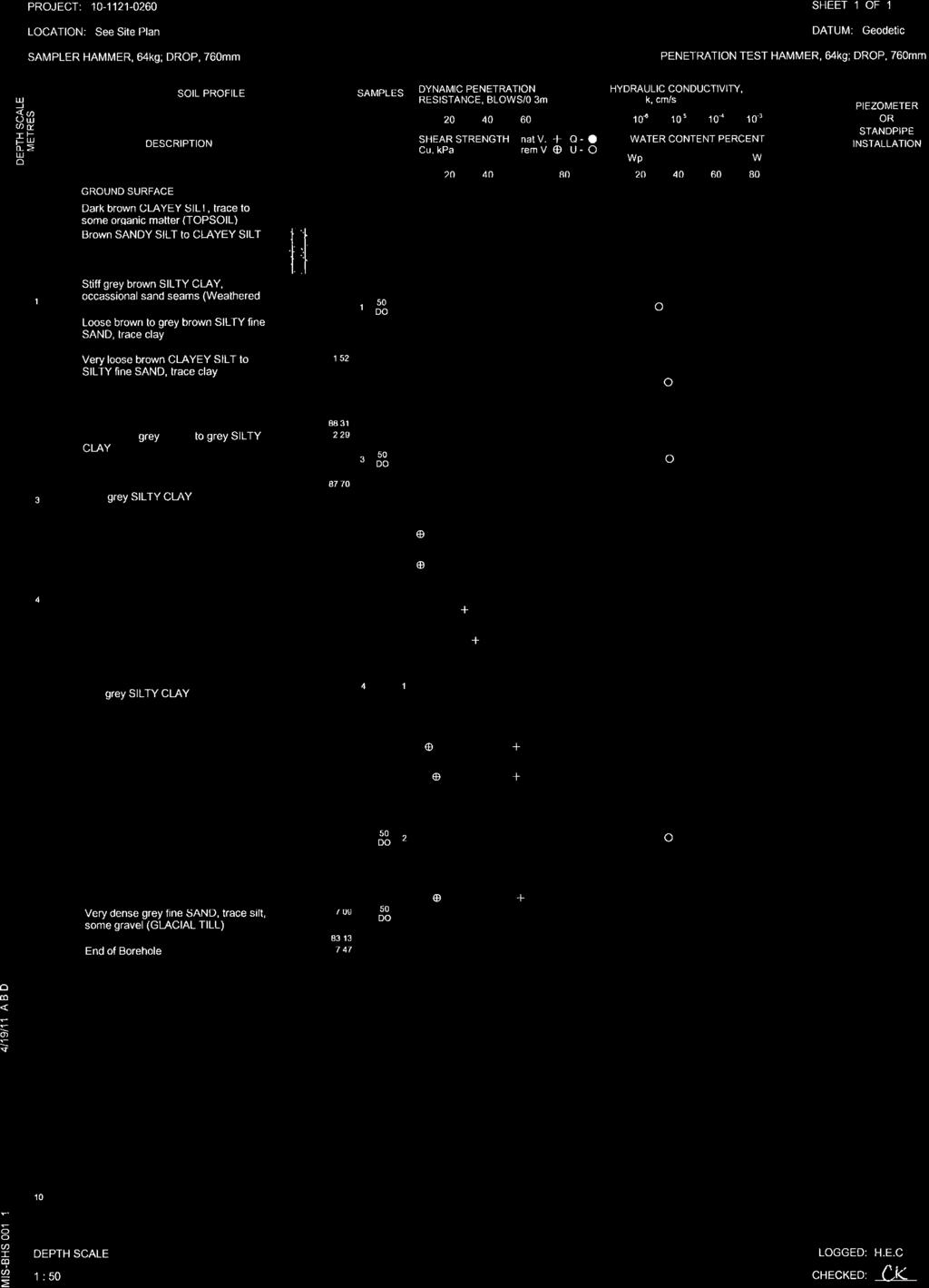
2 Mary Jarvis Urbandale/Riverside South Development Corporation December 10, 201 Procedure The field work for this current investigation was carried out on November 1, 201. At that time, two boreholes (numbered and 1-102) were put down at the approximate locations shown on the attached Site Plan. Both boreholes were advanced using a track-mounted continuous flight hollow-stem auger drill rig, supplied and operated by Marathon Drilling Company Ltd. of Ottawa, Ontario. Standard Penetration Tests (SPTs) were carried out in the boreholes at regular intervals of depth and samples of the soils encountered were recovered using split spoon sampling equipment. In situ vane testing was carried out where possible in the cohesive deposits to determine the undrained shear strength of these soils. The field work was supervised by an experienced technician from our staff who located the boreholes, directed the drilling operations and in situ testing, logged the boreholes and samples, and took custody of the soil samples retrieved. Upon completion of the drilling operations, samples of the soils encountered in the boreholes were transported to our laboratory for further examination by the project engineer. The borehole locations were selected by Golder Associates. The locations were then established and picketed in the field by Annis, O Sullivan, Vollebekk Ltd. (AOV), who also determined the ground surface elevations relative to Geodetic datum. Subsurface Conditions The subsurface conditions encountered in the boreholes put down for the current investigation are shown on the Record of Borehole sheets in Attachment A. The records from relevant boreholes (boreholes 10-1 and 10-15) put down just north and northeast of this proposed development for the previous investigation by Golder Associates are provided in Attachment B. Based on the results of the current investigation and the results of boreholes 10-1 and from the previous investigation, the subsurface conditions on this site generally consist of topsoil overlying layered silty clay, clayey silt, sandy silt and silty sand, over glacial till. Topsoil Topsoil exists at ground surface in all four boreholes and varies from about 20 to 10 millimetres in thickness. Layered Silty Clay, Clayey Silt, Sandy Silt, and Silty Sand Layered deposits of silty clay, clayey silt, sandy silt, and silty sand were encountered in all four boreholes beneath the topsoil. The layered deposits were fully penetrated in two of the boreholes where they extend to depths of about 5.6 and 7.1 metres below the ground surface. In the remaining two boreholes, the deposits were proven to extend to at least about 7. and 8.5 metres below the ground surface. In general, the silty clay and clayey silt layers within the upper 2 to 4 metres of these deposits have been weathered to a grey brown crust with a very stiff to stiff consistency. The silty clay or clayey silt below the depth of weathering is typically grey in colour. The results of in situ vane testing in these deposits gave undrained shear strength typically in the range of 0 to kilopascals, indicating a firm to stiff consistency. The lowest undrained shear strength of about 27 kilopascals was recorded at borehole 10-15, located just northeast of this site. 2
3 Mary Jarvis Urbandale/Riverside South Development Corporation December 10, 201 The thin deposits of sandy silt and/or silty sand encountered within this site are interlayered within the silty clay and clayey silt and have a very loose to loose state of packing. Glacial Till Glacial till was encountered below the layered deposits at boreholes and at depths of about 7.1 and 5.6 metres, respectively, below the ground surface. The glacial till generally consists of a heterogeneous mixture of gravel, cobbles, and boulders in a matrix of silty sand to sand, with a trace of clay. DISCUSSION This section of the memo provides engineering guidelines on the grading and foundation for Phase 9-4 based on our interpretation of the borehole information as well as the project requirements. For guidelines on all other geotechnical issues associated with the design, reference should be made to Golder report ( Rev 1), to which this memo forms an addendum. The guidelines in this memo area also subject to the limitations in the Important Information and Limitations of This Report which follows the text of this memo. Site Grading The subsurface conditions on this site generally consist of layered silty clay, clayey silt, sandy silt, and silty sand overlying glacial till. The softer layered grey silty clay and clayey silt deposits at depth have limited capacity to accept additional load from the weight of grade raise fill and from the foundations of houses without undergoing consolidation settlements. This condition is particularly true for the northeast portion of the site where these deposits are more compressible (near borehole 10-15). Therefore, to leave sufficient remaining capacity for the silty clay and clayey silt to support house foundations, with reasonable footing sizes, the thicknesses of grade raise fill will need to be limited. The following table provides the maximum grade raises which are permitted for the assessment areas within this portion of the site, as indicated on Figure 1. These grade raise limitations have been assessed based on leaving sufficient remaining capacity in the silty clay and clayey silt deposits such that footings up to 0.6 metres in size can be designed using a maximum allowable bearing pressure of at least 75 kilopascals, consistent with design in accordance with Part 9 of the Ontario Building Code. Zone Maximum Permissible Grade Raise (m) C 1.8 D 1.0 It should be noted that these maximum allowable grade raises were calculated assuming that any fill required for site grading (above the original grade) and the backfill within the garages would have a unit weight of no more than 19.5 kilonewtons per cubic metre. Silty clay, clayey silt, sandy silt and silty sand (such as those present on this site), as well as crushed clear stone and uniform fine sand may be suitable for this purpose. Sand and gravel, glacial till, and crushed stone typically have a higher unit weight and, if these materials are to be used, the maximum permissible grade raises would be reduced and would need to be re-evaluated.
4 Mary Jarvis Urbandale/Riverside South Development Corporation December 10, 201 It should also be noted that for any portions of the site where the structures will need to be designed in accordance with Part 4 of the Ontario Building Code, additional geotechnical investigation and guidelines may need to be provided. As a general guideline regarding the site grading, the preparation for filling of the site should include stripping the topsoil for predictable performance of structures and services. The topsoil is not suitable as engineered fill and should be stockpiled separately for re-use in landscaping applications only. In areas with no proposed structures, services, or roadways, the topsoil may be left in-place provided some settlement of the ground surface following filling can be tolerated. Foundations It is considered that the proposed residences may be supported on spread footings founded on or within the layered deposits of weathered silty clay, clayey silt, sandy silt and silty sand. As discussed in the preceding section, the layered deposits have limited capacity to accept the combined load from site grading fill and foundation loads. The allowable bearing pressures for strip footing foundations are therefore based on limiting the stress increases on the firm and compressible grey silty clay and clayey silt at depth to an acceptable level so that foundation settlements do not become excessive. Four important parameters in calculating the stress increase on the grey silty clay and clayey silt are: The thickness of soil below the underside of the footings and above the firm silty clay and clayey silt; The size (dimensions) of the footings; The amount of surcharge in the vicinity of the foundations due to landscape fill, underslab fill, floor loads, etc.; and, The effects of groundwater lowering caused by this or other construction. Provided that the grade raises are restricted to those indicated above, strip footing foundations up to 0.6 metre in width can be designed using a maximum allowable bearing pressure of 75 kilopascals. As such, the house footings may be sized in accordance with Part 9 of the Ontario Building Code. The post-construction total and differential settlements of footings sized using the above maximum allowable bearing pressure should be less than about 25 and 15 millimetres, respectively, provided that the subgrade at or below founding level is not disturbed during construction. Where the proposed grading approaches, but does not exceed, the permissible grade raise values specified in the preceding section, there is greater potential for settlement. The tolerance of the house foundations to accept those settlements could be increased by providing nominal levels of reinforcing steel in the top and bottom of the foundation walls. Further, the provided maximum allowable bearing pressure for footings founded within the silty clay and clayey silt corresponds to settlement resulting from consolidation of these deposits. Consolidation of the silty clay and clayey silt is a process which takes months or longer and, as such, results from sustained loading. Therefore, the foundation loads to be used in conjunction with the allowable bearing pressure should be the full dead load plus sustained live load. 4
5
6

7
8
9 Mary Jarvis Urbandale/Riverside South Development Corporation December 10, 201 ATTACHMENT A Record of Boreholes from Current Investigation 6/7
10 PROJECT: LOCATION: See Site Plan SAMPLER HAMMER, 64kg; DROP, 760mm RECORD OF BOREHOLE: BORING DATE: Nov. 1, 201 SHEET 1 OF 1 DATUM: Geodetic PENETRATION TEST HAMMER, 64kg; DROP, 760mm DEPTH SCALE METRES 0 BORING METHOD GROUND SURFACE SOIL PROFILE DESCRIPTION Black sandy silt with organic matter (TOPSOIL) Very loose grey brown SILTY fine SAND to SANDY SILT STRATA PLOT ELEV. DEPTH (m) SAMPLES NUMBER TYPE BLOWS/0.0m DYNAMIC PENETRATION RESISTANCE, BLOWS/0.m SHEAR STRENGTH Cu, kpa nat V. rem V Q - U - HYDRAULIC CONDUCTIVITY, k, cm/s WATER CONTENT PERCENT Wp W Wl ADDITIONAL LAB. TESTING PIEZOMETER OR STANDPIPE INSTALLATION 1 Very stiff to stiff grey brown SILTY CLAY (Weathered Crust) Power Auger 200mm Diam (Hollow Stem) Firm grey SILTY CLAY WH 6 5 WH 7 MIS-BHS GPJ GAL-MIS.GDT 12/10/1 A.B.D. 8 End of Borehole 9 10 DEPTH SCALE 1 : LOGGED: CHECKED: H.E.C. CK
11 PROJECT: LOCATION: See Site Plan SAMPLER HAMMER, 64kg; DROP, 760mm RECORD OF BOREHOLE: BORING DATE: Nov. 1, 201 SHEET 1 OF 1 DATUM: Geodetic PENETRATION TEST HAMMER, 64kg; DROP, 760mm DEPTH SCALE METRES 0 BORING METHOD GROUND SURFACE SOIL PROFILE DESCRIPTION Black sandy silt, with organic matter (TOPSOIL) Very stiff red brown to grey brown SILTY CLAY (Weathered Crust) STRATA PLOT ELEV. DEPTH (m) SAMPLES NUMBER TYPE BLOWS/0.0m DYNAMIC PENETRATION RESISTANCE, BLOWS/0.m SHEAR STRENGTH Cu, kpa nat V. rem V Q - U - HYDRAULIC CONDUCTIVITY, k, cm/s WATER CONTENT PERCENT Wp W Wl ADDITIONAL LAB. TESTING PIEZOMETER OR STANDPIPE INSTALLATION 1 Very loose grey brown SILTY fine SAND, trace to some clay Very stiff to stiff grey brown SILTY CLAY (Weathered Crust) Power Auger 200mm Diam (Hollow Stem) Firm to stiff grey SILTY CLAY > WH 6 Compact grey SILTY SAND, some gravel, trace clay, with cobbles and boulders (GLACIAL TILL) End of Borehole MIS-BHS GPJ GAL-MIS.GDT 12/10/1 A.B.D DEPTH SCALE 1 : LOGGED: H.E.C. CHECKED: CK

12 Mary Jarvis Urbandale/Riverside South Development Corporation December 10, 201 ATTACHMENT B Record of Boreholes from Previous Investigation 7/7


13
14
Geotechnical Investigation Proposed Richmond Home Hardware Addition 6379 Perth Street Richmond, Ontario
 Geotechnical Investigation Proposed Richmond Home Hardware Addition 6379 Perth Street Richmond, Ontario Houle Chevrier Engineering Ltd. 180 Wescar Lane Ottawa, Ontario K0A 1L0 www.hceng.ca Submitted to:
GEOTECHNICAL INVESTIGATION. Proposed Douglas Street Bus Lane
 May, 0 GEOTECHNICAL INVESTIGATION Proposed Douglas Street Bus Lane Submitted to: Greg Smith P.Eng. Senior Transportation Engineer Urban Systems Ltd. 0- Homer Street Vancouver, BC V6B W9 REPORT Report Number:
Boreholes. Implementation. Boring. Boreholes may be excavated by one of these methods: 1. Auger Boring 2. Wash Boring 3.
 Implementation Boreholes 1. Auger Boring 2. Wash Boring 3. Rotary Drilling Boring Boreholes may be excavated by one of these methods: 4. Percussion Drilling The right choice of method depends on: Ground
Chapter 12 Subsurface Exploration
 Page 12 1 Chapter 12 Subsurface Exploration 1. The process of identifying the layers of deposits that underlie a proposed structure and their physical characteristics is generally referred to as (a) subsurface
Geotechnical Investigation Proposed Retirement Residence Timberwalk Ottawa, Ontario
 September 6 REPORT ON Geotechnical Investigation Proposed Retirement Residence Timberwalk Ottawa, Ontario Submitted to: Claridge Homes Corporation - Gladstone Avenue Ottawa, ON KP Y6 REPORT Report Number:
patersongroup Design for Earthquakes Consulting Engineers May 19, 2016 File: PG3733-LET.01
 patersongroup May 19, 2016 File: PG3733-LET.01 Hydro Ottawa Limited c/o Cresa Toronto 170 University Avenue, Suite 1 Toronto, Ontario M5H 3B3 Attention: Ms. Barbara Wright Consulting Engineers 154 Colonnade
Description of Project and Site
 DATE May, 0 PROJECT No. 09 TO Bob Wingate, P.Eng. IBI Group FROM Stephen Dunlop, P.Eng. EMAIL stdunlop@golder.com PRELIMINARY GEOTECHNICAL AND HYDROGEOLOGICAL INVESTIGATION (REV.) PROPOSED STORMWATER MANAGEMENT
Civil Engineering, Surveying and Environmental Consulting WASP0059.ltr.JLS.Mich Ave Bridge Geotech.docx
 2365 Haggerty Road South * Canton, Michigan 48188 P: 734-397-3100 * F: 734-397-3131 * www.manniksmithgroup.com August 29, 2012 Mr. Richard Kent Washtenaw County Parks and Recreation Commission 2330 Platt
REPORT. Site Plan Application Pace Redevelopment Stouffville, Ontario. June 7, 2012 PRELIMINARY GEOTECHNICAL INVESTIGATION
 June 7, 2012 PRELIMINARY GEOTECHNICAL INVESTIGATION Site Plan Application Pace Redevelopment Stouffville, Ontario Submitted to: Mr. Terry Chapman Pace Savings & Credit Union Limited 8111 Jane Street, Unit
Geotechnical Investigation Proposed Commercial Development 1095 Algoma Road Ottawa, Ontario
 February 2016 REPORT ON Geotechnical Investigation Proposed Commercial Development 1095 Algoma Road Ottawa, Ontario Submitted to: 1095 Algoma Road Inc. 1294 Algoma Road Ottawa, Ontario K1B 3W8 REPORT Report
REPORT ON SUPPLEMENTAL GEOTECHNICAL INVESTIGATION ABBOTT FERNBANK HOLDINGS INC. PROPERTY FERNBANK ROAD OTTAWA, ONTARIO.
 8 escar Lane R.R. Carp, Ontario, KA L Tel: (6) 86- Fax: (6) 86-97 www.hceng.ca REPT ON SUPPLEMENTAL GEOTECHNICAL INVESTIGATION ABBOTT FERNBANK HOLDINGS INC. PROPERTY FERNBANK ROAD OTTAA, ONTARIO Submitted
3.0 SITE COMPARISON GEOLOGY, HYDROGEOLOGY & GEOTECHNICAL 3.1 Comparison of Sites
 APPENDIX TSD#-B COMPARATIVE EVALUATION OF ALTERNATIVE SITES GEOLOGY, HYDROGEOLOGY & GEOTECHNICAL COMPONENT Environmental Component Summary of Site Considerations Interpreted direction of vertical groundwater
M E M O R A N D U M. Mr. Jonathan K. Thrasher, P.E., Mr. Ian Kinnear, P.E. (FL) PSI
 PSI") M E M O R A N D U M TO: FROM: Mr. Mark Schilling Gulf Interstate Engineering Mr. Jonathan K. Thrasher, P.E., Mr. Ian Kinnear, P.E. (FL) PSI DATE: November 11, 2014 RE: Summary of Findings Geotechnical
M E M O R A N D U M TO: FROM: Mr. Mark Schilling Gulf Interstate Engineering Mr. Jonathan K. Thrasher, P.E., Mr. Ian Kinnear, P.E. (FL) PSI DATE: November 11, 2014 RE: Summary of Findings Geotechnical
Updated Subsurface Investigation Block A Heritage Hills Development 124 Battersea Crescent Ottawa, Ontario
 Updated Subsurface Investigation Block A Heritage Hills Development 124 Battersea Crescent Ottawa, Ontario Submitted to: Brigil Homes 98 rue Lois Gatineau, Quebec J8Y 3R7 Updated Subsurface Investigation
SLOPE STABILITY ASSESSMENT PROPOSED RESIDENTIAL SUBDIVISION 161 LAKESHORE ROAD EAST TOWN OF THE BLUE MOUNTAINS, ONTARIO
 SLOPE STABILITY ASSESSMENT PROPOSED RESIDENTIAL SUBDIVISION 161 LAKESHORE ROAD EAST TOWN OF THE BLUE MOUNTAINS, ONTARIO PETO MacCALLUM LTD. 19 CHURCHILL DRIVE BARRIE, ONTARIO L4N 8Z5 PHONE: (705) 734-3900
Geotechnical Investigation
 Geotechnical Investigation Slope Stability Analysis for the Existing Slope Southwest of the Proposed Condo Developments 50 Ann Street, Bolton, Ontario Prepared For: Brookfield Homes (Ontario) Limited GeoPro
ENCE 3610 Soil Mechanics. Site Exploration and Characterisation Field Exploration Methods
 ENCE 3610 Soil Mechanics Site Exploration and Characterisation Field Exploration Methods Geotechnical Involvement in Project Phases Planning Design Alternatives Preparation of Detailed Plans Final Design
B-1 BORE LOCATION PLAN. EXHIBIT Drawn By: 115G BROOKS VETERINARY CLINIC CITY BASE LANDING AND GOLIAD ROAD SAN ANTONIO, TEXAS.
 N B-1 SYMBOLS: Exploratory Boring Location Project Mngr: BORE LOCATION PLAN Project No. GK EXHIBIT Drawn By: 115G1063.02 GK Scale: Checked By: 1045 Central Parkway North, Suite 103 San Antonio, Texas 78232
patersongroup memorandum
 patersongroup memorandum consulting engineers to: David Schaeffer Engineering Limited - Ms. Jennifer Ailey - jailey@dsel.ca to: Richcraft Homes - Mr. Phil Castro - PhilC@Richcraft.com re: Limit of Hazard
Terraprobe Consulting Geotechnical & Environmental Engineering Construction Materials Inspection & Testing
 Terraprobe Consulting Geotechnical & Environmental Engineering Construction Materials Inspection & Testing GEOTECHNICAL INVESTIGATION BLOCKS TO PIER HAMILTON, ONTARIO PREPARED FOR: City of Hamilton Waterfront
(C) Global Journal of Engineering Science and Research Management
 Global Journal of Engineering Science and Research Management") GEOTECHNCIAL ASSESSMENT OF PART OF PORT HARCOURT, NIGER DELTA FOR STRUCTURAL ANALYSIS Warmate Tamunonengiyeofori Geostrat International Services Limited, www.geostratinternational.com. *Correspondence
GEOTECHNCIAL ASSESSMENT OF PART OF PORT HARCOURT, NIGER DELTA FOR STRUCTURAL ANALYSIS Warmate Tamunonengiyeofori Geostrat International Services Limited, www.geostratinternational.com. *Correspondence
Geotechnical Investigation Proposed Retirement Residence Goulbourn Forced Road Ottawa, Ontario
 REPORT February 205 REPORT ON Geotechnical Investigation Proposed Retirement Residence Goulbourn Forced Road Ottawa, Ontario Submitted to: Dan Roach, AIA Hawthorne Development LLC c/o Lenity Architecture
SITE INVESTIGATION 1
 SITE INVESTIGATION 1 Definition The process of determining the layers of natural soil deposits that will underlie a proposed structure and their physical properties is generally referred to as site investigation.
patersongroup Consulting Engineers April 20, 2010 File: PG1887-LET.01R Novatech Engineering Consultants Suite 200, 240 Michael Cowpland Drive
 patersongroup April 20, 2010 File: PG1887-LET.01R Novatech Engineering Consultants Suite 200, 240 Michael Cowpland Drive Ottawa, Ontario K2M 1P6 Attention: Mr. Adam Thompson Consulting Engineers 28 Concourse
REPORT ON SLOPE STABILITY INVESTIGATION DON MILLS ROAD AND EGLINTON AVENUE EAST TORONTO, ONTARIO. Prepared for:
 REPORT ON SLOPE STABILITY INVESTIGATION DON MILLS ROAD AND EGLINTON AVENUE EAST TORONTO, ONTARIO Prepared for: TORONTO AND REGION CONSERVATION AUTHORITY Prepared By: SIRATI & PARTNERS CONSULTANTS LIMITED
patersongroup memorandum 1.0 Field Investigation consulting engineers
 consulting engineers memorandum to: KDSA Development Corporation - Ms. Susan Anglin - susananglin6@gmail.com re: Pavement Structure Recommendations - Shady Maple Road Proposed Braeburn Estates Residential
Hydro One (Sept 2014) Hydro One (Sept 2014) Hydro One (Sept 2014)
 Hydro One (Sept 2014) Hydro One (Sept 2014)") TABLE 1 WELL CONSTRUCTION DETAILS MOE WWR No Well ID Location Installation Date Status Easting Coordinates Northing Source Elevation Screened Interval Screened Material Borehole Well Stick-up Ground Top
TABLE 1 WELL CONSTRUCTION DETAILS MOE WWR No Well ID Location Installation Date Status Easting Coordinates Northing Source Elevation Screened Interval Screened Material Borehole Well Stick-up Ground Top
ATTACHMENT A PRELIMINARY GEOTECHNICAL SUMMARY
 ATTACHMENT A PRELIMINARY GEOTECHNICAL SUMMARY Kevin M. Martin, P.E. KMM Geotechnical Consultants, LLC 7 Marshall Road Hampstead, NH 0384 603-489-6 (p)/ 603-489-8 (f)/78-78-4084(m) kevinmartinpe@aol.com
June 9, R. D. Cook, P.Eng. Soils Engineer Special Services Western Region PUBLIC WORKS CANADA WESTERN REGION REPORT ON
 PUBLIC WORKS CANADA WESTERN REGION REPORT ON GEOTECHNICAL INVESTIGATION PROPOSED MARTIN RIVER BRIDGE MILE 306.7 MACKENZIE HIGHWAY Submitted by : R. D. Cook, P.Eng. Soils Engineer Special Services Western
APPENDIX A GEOTECHNICAL REPORT
 The City of Winnipeg Bid Opportunity No. 529-2017 Template Version: C420170317 - RW APPENDIX A GEOTECHNICAL REPORT Quality Engineering Valued Relationships KGS Group 2017 Industrial Street Rehabilitation
Reference No S072 APRIL 2012
 A REPORT TO SOLMAR DEVELOPMENT CORP. A PRELIMINARY SOIL INVESTIGATION FOR PROPOSED SUBDIVISION DEVELOPMENT NORTHEAST OF SIDEROAD 5 AND 0 LINE TOWN OF ERIN Reference No. 202-S072 APRIL 202 DISTRIBUTION
 Project: ITHACA-TOMPKINS REGIONAL AIRPORT EXPANSION Project Location: ITHACA, NY Project Number: 218-34 Key to Soil Symbols and Terms TERMS DESCRIBING CONSISTENCY OR CONDITION COARSE-GRAINED SOILS (major
VOLUME III GEOLOGY, HYDROGEOLOGY & GEOTECHNICAL REPORT CAPITAL REGION RESOURCE RECOVERY CENTRE
 VOLUME III GEOLOGY, HYDROGEOLOGY & GEOTECHNICAL REPT CAPITAL REGION RESOURCE RECOVERY CENTRE APPENDIX A Borehole Records December Report No. //vol III LIST OF ABBREVIATIONS The abbreviations coonly employed
patersongroup 1.0 Geotechnical Desktop Review Consulting Engineers April 18, 2017 PG4080-LET.01
 patersongroup April 18, 2017 PG080-LET.01 2015-2017 RR Ltd 311 Richmond Road, Suite 203 Ottawa, ON K1Z 6X3 Attention: Subject: Mr. Jonah Bonn Geotechnical Desktop Review Proposed Drive-Thru Lanes 2015-2017
DATA REPORT GEOTECHNICAL INVESTIGATION GALVESTON CRUISE TERMINAL 2 GALVESTON, TEXAS
 DATA REPORT GEOTECHNICAL INVESTIGATION GALVESTON CRUISE TERMINAL 2 GALVESTON, TEXAS SUBMITTED TO PORT OF GALVESTON 123 ROSENBERG AVENUE, 8TH FLOOR GALVESTON, TEXAS 77553 BY HVJ ASSOCIATES, INC. HOUSTON,
GEOTECHNICAL REPORT CBSA Facility Redevelopment Thousand Islands International Crossing Lansdowne, Ontario
 GEOTECHNICAL REPORT CBSA Facility Redevelopment Thousand Islands International Crossing Lansdowne, Ontario Prepared For: The Federal Bridge Corporation Limited SPL Project No.: 10001084 Report Date: January
APPENDIX A. Borehole Logs Explanation of Terms and Symbols
 APPENDIX A Borehole Logs Explanation of Terms and Symbols Page 153 of 168 EXPLANATION OF TERMS AND SYMBOLS The terms and symbols used on the borehole logs to summarize the results of field investigation
Appendix H. Geotechnical Investigation Report. Krosno Creek Flood Reduction Project PROJECT FILE REPORT CITY OF PICKERING
 Krosno Creek Flood Reduction Project PROJECT FILE REPORT CITY OF PICKERING Appendix H Geotechnical Investigation Report TMIG THE MUNICIPAL INFRASTRUCTURE GROUP LTD Report on Geotechnical Investigation
 SOIL CLASSIFICATION CHART COARSE-GRAINED SOILS MORE THAN 50% RETAINED ON NO.200 SIEVE FINE-GRAINED SOILS 50% OR MORE PASSES THE NO.200 SIEVE PRIMARY DIVISIONS GRAVELS MORE THAN 50% OF COARSE FRACTION RETAINED
GEOTECHNICAL INVESTIGATION REPORT
 GEOTECHNICAL INVESTIGATION REPORT DH 1404-05 ACCOMODATE SPECIALIZED EQUIPMENT, DWYER HILL TRAINING CENTRE RICHMOND, ONTARIO Prepared for: Defence Construction Canada (DCC) Date: February 2016 Report No.:
Geotechnical Investigation Proposed Residential Development 99 Beechwood Avenue Ottawa, Ontario
 REPORT REPORT ON Geotechnical Investigation Proposed Residential Development 99 Beechwood Avenue Ottawa, Ontario Submitted to: Claridge Homes 210 Gladstone Avenue, Suite 2001 Ottawa, Ontario K2P 0Y6 Report
DRAFT GEOTECHNICAL INVESTIGATION REPORT
 DRAFT GEOTECHNICAL INVESTIGATION REPORT PROPOSED NEW SEWER INSTALLATION CITY OF CLARENCE-ROCKLAND, ONTARIO Prepared for: City of Clarence-Rockland 151-03483-00 Date: July 2015 WSP Canada Inc. 500 Greber
The attitude he maintains in his relation to the engineer is very well stated in his own words:
 Su bsurface Soil Exploration, 53: 139 Foundation Engineering Geotechnical companies that have a history of experience in a given region usually have extensive boring logs and maps telling where the borings
Subsurface Investigation Proposed Commercial Building 528 March Road Ottawa, Ontario
 Subsurface Investigation Proposed Commercial Building 8 March Road Ottawa, Ontario Houle Chevrier Engineering Ltd. 80 Wescar Lane Ottawa, Ontario K0A L0 www.hceng.ca Submitted to: Broccolini Construction
Slope Stability Assessment Proposed Development 4401 Fallowfield Road Lands Ottawa, Ontario Rev-02
 REPORT August 2014 REPORT ON Slope Stability Assessment Proposed Development 4401 Fallowfield Road Lands Ottawa, Ontario Submitted to: DCR Phoenix Homes 18 Bentley Avenue Ottawa, Ontario K2E 6T8 Report
 Photo 1 - Southerly view across 2700 parking lot toward existing building. Multi-residential building borders western side of property in upper right of view. Photo 2 - Southerly view across 2750 parking
Northern Colorado Geotech
 PRELIMINARY GEOTECHNICAL ENGINEERING REPORT PROPOSED CECIL FARMS DEVELOPMENT WELD COUNTY ROAD 7, BETWEEN ROADS 7 AND 7 SEVERANCE, COLORADO NORTHERN COLORADO GEOTECH PROJECT NO. 0-6 APRIL 0, 06 Prepared
Depth (ft) USCS Soil Description TOPSOIL & FOREST DUFF
 USCS Soil Description TOPSOIL & FOREST DUFF") Test Pit No. TP-6 Location: Latitude 47.543003, Longitude -121.980441 Approximate Ground Surface Elevation: 1,132 feet Depth (ft) USCS Soil Description 0 1.5 1.5 5.0 SM 5.0 8.0 SM Loose to medium dense,
Test Pit No. TP-6 Location: Latitude 47.543003, Longitude -121.980441 Approximate Ground Surface Elevation: 1,132 feet Depth (ft) USCS Soil Description 0 1.5 1.5 5.0 SM 5.0 8.0 SM Loose to medium dense,
 R-1 Conveyor Relocation Project Legend 0 500 1000 1500 ft. This map is a user generated static output from an Internet mapping site and is for general reference only. Data layers that appear on this map
APPENDIX C. Borehole Data
 APPENDIX C Borehole Data MAJOR DIVISIONS SOIL CLASSIFICATION CHART SYMBOLS GRAPH LETTER TYPICAL DESCRIPTIONS ADDITIONAL MATERIAL
Appendix A. Producer Statement Advisory Note
 Appendix A Producer Statement Advisory Note Ref. No. 17095 26 May 2017 PRODUCER STATEMENT CONSTRUCTION REVIEW (PS4) IMPORTANT ADVISORY NOTE The Building Consent Authority (BCA) frequently requires Producer
Limited Geotechnical Engineering Evaluation Classroom Additions Albany County Campus Laramie, Wyoming
 Limited Geotechnical Engineering Evaluation Classroom Additions Albany County Campus 2300 Missile Drive, Cheyenne, Wyoming 82001 Phone 307-635-0222 www.stratageotech.com Limited Geotechnical Engineering
patersongroup Geotechnical Investigation Proposed Industrial Building 1670 Comstock Road Ottawa, Ontario Prepared For Simluc Contractors Limited
 Geotechnical Engineering Environmental Environmental Engineering Engineering Hydrogeology Hydrogeology Geological Engineering Geological Engineering Materials Testing Materials Testing Building Science
16 January 2018 Job Number: RICHARD NEWMAN C\- CLARK FORTUNE MCDONALD AND ASSOCIATES PO BOX 553 QUEENSTOWN
 16 January 2018 Job Number: 50595 RICHARD NEWMAN C\- CLARK FORTUNE MCDONALD AND ASSOCIATES PO BOX 553 QUEENSTOWN CHANSEN@CFMA.CO.NZ STORMWATER DISPOSAL ASSESSMENT Dear Richard, RDAgritech were requested
Geotechnical Indications Of Eastern Bypass Area In Port Harcourt, Niger Delta
 Geotechnical Indications Of Eastern Bypass Area In Port Harcourt, Niger Delta Warmate Tamunonengiyeofori Geostrat International Services Limited, Rivers State, Nigeria www.geostratinternational.com info@geostratinternational.com,
SCOPE OF INVESTIGATION Simple visual examination of soil at the surface or from shallow test pits. Detailed study of soil and groundwater to a
 Lecture-5 Soil Exploration Dr. Attaullah Shah 1 Today s Lecture Purpose of Soil Exploration Different methods 1. Test trenches and Pits 2. Auger and Wash Boring 3. Rotary Drilling 4. Geophysical Methods
Geotechnical Investigation Juneau Seawalk - Taku Fisheries to Miner s Wharf Juneau, Alaska DM&A Job No
 Duane Miller & Associates 5821 Arctic Boulevard, Suite A Anchorage, AK 99518-1654 (907) 644-3200 Fax 644-0507 Arctic & Geotechnical Engineering May 4, 2006 Tetra Tech/KCM, Inc. 1971 First Avenue Seattle,
CENTRAL REGION GEOHAZARDS RISK ASSESSMENT SITE INSPECTION FORM
 SITE NUMBER AND NAME C55 H861:02 Slide LEGAL DESCRIPTION NW 14-40-14-W4 CENTRAL REGION GEOHAZARDS RISK ASSESSMENT SITE INSPECTION FORM HIGHWAY & KM NAD 83 COORDINATES N 5811217 E 437291 PREVIOUS INSPECTION
patersongroup Geotechnical Investigation Proposed Elementary School 2300 Esprit Drive Ottawa, Ontario Prepared For Ottawa Catholic School Board
 Geotechnical Engineering Environmental Engineering Hydrogeology Geological Engineering Materials Testing Building Science Proposed Elementary School 300 Esprit Drive Archaeological Services Prepared For
APPENDIX E SOILS TEST REPORTS
 Otsego County, NY Site Work Specifications APPENDIX E SOILS TEST REPORTS Blue Wing Services, Inc. July 1, 2010 Blue Wing Services May 20, 2010 Page 2 the site, was not made available to Empire at this
The process of determining the layers of natural soil deposits that will underlie a proposed structure and their physical properties is generally
 The process of determining the layers of natural soil deposits that will underlie a proposed structure and their physical properties is generally referred to as sub surface investigation 2 1 For proper
REPORT OF SUBSURFACE EXPLORATION
 REPORT OF SUBSURFACE EXPLORATION GRAND RIVER DAM AUTHORITY HULBERT 69 KV SWITCHING STATION S. 440 Road Hulbert, Cherokee County, Oklahoma ENERCON PROJECT NO. GRDA006 MARCH 7, 2012 PREPARED FOR: C/O ENERCON
Geotechnical Engineering Subsurface Investigation Report 13-SI-7-BH-1Page)
") Geotechnical Engineering Subsurface Investigation Report 3-SI-7-BH-Page) Canadian Shield Avenue, Kanata, ON, K2K H4 Abstract: This report present the findings of the geotechnical investigation completed
Geotechnical Engineering Subsurface Investigation Report 3-SI-7-BH-Page) Canadian Shield Avenue, Kanata, ON, K2K H4 Abstract: This report present the findings of the geotechnical investigation completed
Geotechnical Engineering Study, Conifer Senior High School Football Field Improvements, Conifer, Colorado
 2390 South Lipan Street Denver, CO 80223 phone: (303) 742-9700 fax: (303) 742-9666 email: kadenver@kumarusa.com www.kumarusa.com Office Locations: Denver (HQ), Colorado Springs, Fort Collins, and Frisco,
GEOTECHNICAL INVESTIGATION REPORT INFRASTRUCTURE PVT LTD
 GEOTECHNICAL INVESTIGATION REPORT Client : TAEIN CONSTRUCTION & INFRASTRUCTURE PVT LTD Office address : Flat No.104, A -Wing,1st floor,gloria Park, Paranjape Scheme, Bavdhan Khurd, Chandni Chowk, Pune
GEOTECHNICAL SITE INVESTIGATION REPORT SUBDIVISION - SELECTED LOTS AKISQNUK FIRST NATION WINDERMERE, BC
 GEOTECHNICAL SITE INVESTIGATION REPORT SUBDIVISION - SELECTED LOTS AKISQNUK FIRST NATION WINDERMERE, BC Prepared For: Akisqnuk First Nation Windermere, BC Box 688 Fernie, BC V0B 1M0 250 423 4829 August
December 5, Junction Gateway, LLC 7551 W. Sunset Boulevard #203 Los Angeles, CA Mr. James Frost P: Dear Mr.
 December 5, 2014 Junction Gateway, LLC 7551 W. Sunset Boulevard #203 90046 Attn: Re: Mr. James Frost P: 323.883.1800 Geotechnical Update Letter Sunset & Effie Mixed Use Development 4301 to 4311 Sunset
Geotechnical Data Report
 Geotechnical Data Report Downtown Greenville Future Conveyance Study December 1, 2015 Terracon Project No. 86155032 Prepared for: Prepared by: Terracon Consultants, Inc. December 1, 2015 561 Mauldin Road
February 22, 2016 AG File No
 Ainley Graham & Associates Limited 1-50 Grant Timmins Drive, Kingston, Ontario, K7M 8N2 Tel: (343) 266-0002 Fax: (343) 266-0028 E-mail Kingston@ainleygroup.com February 22, 2016 AG File No. 15062-1 Ministry
How & Where does infiltration work? Summary of Geologic History Constraints/benefits for different geologic units
 June 26, 2007: Low Impact Development 1 Associated Earth Sciences, Inc. Associated Earth Sciences, Inc. Presented by: Matthew A. Miller, PE April 24, 2012 How & Where does infiltration work? Summary of
SOME OBSERVATIONS RELATED TO LIQUEFACTION SUSCEPTIBILITY OF SILTY SOILS
 SOME OBSERVATIONS RELATED TO LIQUEFACTION SUSCEPTIBILITY OF SILTY SOILS Upul ATUKORALA 1, Dharma WIJEWICKREME 2 And Norman MCCAMMON 3 SUMMARY The liquefaction susceptibility of silty soils has not received
DRILL HOLE # BH-BGC13-FN-01
 DILL HOLE # BH-BGC3-FN-0 Drill Method: Mud otary/coring Depth To ock (m): N/A Page of 7 eviewed by: AJB 0 GAVEL (GW) Fine to coarse, sandy, well graded, dense, max particle size = 30 mm, angular to subrounded,
Mitigation of Liquefaction Potential Using Rammed Aggregate Piers
 ASCE 2011 557 Mitigation of Liquefaction Potential Using Rammed Aggregate Piers R.W. Rudolph, M. ASCE, G.E. 1, B. Serna, M. ASCE, P.E. 2, and T. Farrell, M. ASCE, G.E. 3 1 Principal Consultant, ENGEO,
APPENDIX C HYDROGEOLOGIC INVESTIGATION
 Figure B-5.7 Figure B-5.8 Preliminary Geotechnical and Environmental Report Appendix C Hydrogeologic Investigation APPENDIX C HYDROGEOLOGIC INVESTIGATION December 21, 2011 WESTSIDE SUBWAY EXTENSION PROJECT
IN SITU SPECIFIC GRAVITY VS GRAIN SIZE: A BETTER METHOD TO ESTIMATE NEW WORK DREDGING PRODUCTION
 IN SITU SPECIFIC GRAVITY VS GRAIN SIZE: A BETTER METHOD TO ESTIMATE NEW WORK DREDGING PRODUCTION Nancy Case O Bourke, PE 1, Gregory L. Hartman, PE 2 and Paul Fuglevand, PE 3 ABSTRACT In-situ specific gravity
Soils. Technical English - I 10 th week
 Technical English - I 10 th week Soils Soil Mechanics is defined as the branch of engineering science which enables an engineer to know theoretically or experimentally the behavior of soil under the action
REPORT OF PRELIMINARY GEOTECHNICAL EXPLORATION
 REPORT OF PRELIMINARY GEOTECHNICAL EXPLORATION ENKA INTERMEDIATE SCHOOL Sand Hill Road Candler, North Carolina Prepared For: BUNCOMBE COUNTY SCHOOLS Prepared By: AMEC ENVIRONMENT & INFRASTRUCTURE, INC.
Geotechnical Recommendations for Proposed Additions to the Three Mile Creek Severe Weather Attenuation Tank Project
 TECHNICAL MEMORANDUM Geotechnical Recommendations for Proposed Additions to the Three Mile Creek Severe Weather Attenuation Tank Project PREPARED FOR: PREPARED BY: DATE: June 28, 218 PROJECT NUMBER: 697482
Soil type identification and fines content estimation using the Screw Driving Sounding (SDS) data
 data") Mirjafari, S.Y. & Orense, R.P. & Suemasa, N. () Proc. th NZGS Geotechnical Symposium. Eds. GJ Alexander & CY Chin, Napier Soil type identification and fines content estimation using the Screw Driving Sounding
Mirjafari, S.Y. & Orense, R.P. & Suemasa, N. () Proc. th NZGS Geotechnical Symposium. Eds. GJ Alexander & CY Chin, Napier Soil type identification and fines content estimation using the Screw Driving Sounding
SI Planning & Laboratory Testing for Hill-Site Development
 SI Planning & Laboratory Testing for Hill-Site Development 21 April 2009 IEM Penang Ir. Tan Yean Chin G&P Geotechnics Sdn Bhd Cameron Highlands, 1961 Genting Highland Tower 1993 Bukit Antarabangsa, 1999
3.0 SUMMARY OF FINDINGS
 AECOM 500 W Jefferson St. Suite 1600 Louisville, KY 40202 www.aecom.com 502-569-2301 tel 502-569-2304 fax October 17, 2018 Big Rivers Electric Corporation Sebree Generating Station 9000 Highway 2096 Robards,
STUDY ON CONSOLIDATION OF ALLUVIAL CLAY IN NORTHERN QUEENSLAND
 STUDY ON CONSOLIDATION OF ALLUVIAL CLAY IN NORTHERN QUEENSLAND Barry Wai Choo, Kok Geotechnical Services Manager, Abigroup Australia Dr. Richard Gong Senior Geotechnical Engineer, AECOM Australia ABSTRACT
From - To 0,00-4,90 4,90-6,40 6,40-8,60 8,60-9,60 9,60-10,50 10,50-12,00 12,00-14,80 14,80-15,80 15,80-19,30 19, ,00
 Závěrka 12,Praha 6,169 00 Log of Boring BH1 Project ID: 2018_A-017 Annex no.: A.1G Drilling equipment: Hütte 202 TF Location: Prague 12 Overall depth: 2 m Borehole position: Date start: 22.11.2017 Foreman:
Predicting Settlement and Stability of Wet Coal Ash Impoundments using Dilatometer Tests
 Predicting Settlement and Stability of Wet Coal Ash Impoundments using Dilatometer Tests Chris Hardin, P.E. CH2M Hill, Charlotte, North Carolina, E-mail: Chris.Hardin@ch2m.com Roger Failmezger, P.E., F.
APPENDIX F CORRELATION EQUATIONS. F 1 In-Situ Tests
 APPENDIX F 1 APPENDIX F CORRELATION EQUATIONS F 1 In-Situ Tests 1. SPT (1) Sand (Hatanaka and Uchida, 1996), = effective vertical stress = effective friction angle = atmosphere pressure (Shmertmann, 1975)
Safe bearing capacity evaluation of the bridge site along Syafrubesi-Rasuwagadhi road, Central Nepal
 Bulletin of the Department of Geology Bulletin of the Department of Geology, Tribhuvan University, Kathmandu, Nepal, Vol. 12, 2009, pp. 95 100 Safe bearing capacity evaluation of the bridge site along
Hydraulic uplift forces on basements subject to liquefaction
 Hydraulic uplift forces on basements subject to liquefaction N.S. Luxford Babbage Consultants Ltd 2014 NZSEE Conference ABSTRACT: As a result of the 22 February 2011 earthquake in Christchurch a building
KDOT Geotechnical Manual Edition. Table of Contents
 KDOT Geotechnical Manual 2007 Edition The KDOT Geotechnical Manual is available two volumes. Both volumes are very large electronic (pdf) files which may take several minutes to download. The table of
GEOTECHNICAL REPORT. Matanuska-Susitna Borough. Parks Highway Connections Museum Drive. Matanuska-Susitna Borough, Alaska.
 Matanuska-Susitna Borough GEOTECHNICAL REPORT Parks Highway Connections Museum Drive Matanuska-Susitna Borough, Alaska March 2, 20 Prepared By: John Thornley, PE Geotechnical Engineer 333 Arctic Blvd.,
GEOTECHNICAL INVESTIGATION MULTIPLE STREETS AND ROADS F18-INF CITY OF CLARENCE-ROCKLAND
 GEOTECHNICAL INVESTIGATION MULTIPLE STREETS AND ROADS F18-INF-2018-012 CITY OF CLARENCE-ROCKLAND Prepared for: The City of Clarence-Rockland Attn: Mr. Alain Beaulieu, Coordinator, Capital Projects 1560
CITY OF CAPE CORAL NORTH 2 UTILITIES EXTENSION PROJECT CONTRACT 3
 GEOTECHNICAL REPORT CITY OF CAPE CORAL NORTH UTILITIES EXTENSION PROJECT CONTRACT City of Cape Coral Procurement Division Cultural Park Boulevard, nd Floor Cape Coral, FL ISSUED FOR BID VOLUME of GEOTECHNICAL
Geotechnical Engineering Subsurface Investigation Report 13-SI-7-BH-1BPage)
") Geotechnical Engineering Subsurface Investigation Report 3-SI-7-BH-BPage) Canadian Shield Avenue, Kanata, ON, K2K H4 Abstract: This report present the findings of the geotechnical investigation completed
Geotechnical Engineering Subsurface Investigation Report 3-SI-7-BH-BPage) Canadian Shield Avenue, Kanata, ON, K2K H4 Abstract: This report present the findings of the geotechnical investigation completed
FINAL REPORT, GEOTECHNICAL INVESTIGATION, NORTHWEST RIVER BRIDGE RECONSTRUCTION, TERRA NOVA NATIONAL PARK, NL. File No:
 FINAL REPORT, GEOTECHNICAL INVESTIGATION, NORTHWEST RIVER BRIDGE RECONSTRUCTION, TERRA NOVA NATIONAL PARK, NL File No: 6847 Prepared for: Harbourside Engineering Consultants 9 Waverly Road, Suite Dartmouth
GEOTECHNICAL INVESTIGATION Paq tnkek First Nation Underpass (Ant 275) Antigonish County, Nova Scotia
 Antigonish County, Nova Scotia") GEOTECHNICAL INVESTIGATION Paq tnkek First Nation Underpass (Ant 75) Antigonish County, Nova Scotia Stantec Consulting Ltd. 847 Highway 04 Antigonish NS BG K7 Tel: (90) 86-5805 Fax: (90) 86-5806 Report
GEOTECHNICAL INVESTIGATION Paq tnkek First Nation Underpass (Ant 75) Antigonish County, Nova Scotia Stantec Consulting Ltd. 847 Highway 04 Antigonish NS BG K7 Tel: (90) 86-5805 Fax: (90) 86-5806 Report
Soil Mechanics Brief Review. Presented by: Gary L. Seider, P.E.
 Soil Mechanics Brief Review Presented by: Gary L. Seider, P.E. 1 BASIC ROCK TYPES Igneous Rock (e.g. granite, basalt) Rock formed in place by cooling from magma Generally very stiff/strong and often abrasive
GEOTECHNICAL INVESTIGATION REPORT
 GEOTECHNICAL INVESTIGATION REPORT SOIL INVESTIGATION REPORT FOR STATIC TEST FACILITY FOR PROPELLANTS AT BDL, IBRAHIMPATNAM. Graphics Designers, M/s Architecture & Engineering 859, Banjara Avenue, Consultancy
PRELIMINARY GEOTECHNICAL ENGINEERING REPORT. Proposed Re-Development 44 Old Worcester Road Charlton, Massachusetts. Prepared For:
 PRELIMINARY GEOTECHNICAL ENGINEERING REPORT Proposed Re-Development 44 Old Worcester Road Charlton, Massachusetts Prepared For: Meridian Associates, Inc. 500 Cummings Center, Suite 5950 Beverly, Massachusetts
R.M.HARW & ASSOCIATES LTD. GEOTECHNICAL INVESTIGATION PROPOSED BRIDGE SITE. HELAVA CREEKl MILE MACKENZIE HIGHWAY E-2510 OCTOBER 16, 1973
 El R.M.HARW & ASSOCIATES LTD. GEOTECHNICAL INVESTIGATION PROPOSED BRIDGE SITE HELAVA CREEKl MILE 616.4 MACKENZIE HIGHWAY E-2510 OCTOBER 16, 1973 R,M,HARDV & ASSOCIATES LTD. CONSULTING ENGINEERING & TESTING
CONQUEST ENGINEERING LTD.
 CONQUEST ENGINEERING LTD. Geotechnical and Materials Engineers Concrete Technology, Blasting Consultants Construction Quality Assurance / Quality Control 8 Bluewater Road, Bedford, NS BB J6 Phone (9)85-7
Pierce County Department of Planning and Land Services Development Engineering Section
 Page 1 of 7 Pierce County Department of Planning and Land Services Development Engineering Section PROJECT NAME: DATE: APPLICATION NO.: PCDE NO.: LANDSLIDE HAZARD AREA (LHA) GEOLOGICAL ASSESSMENT REPORT