Terraprobe Consulting Geotechnical & Environmental Engineering Construction Materials Inspection & Testing
|
|
|
- Bryan Patterson
- 5 years ago
- Views:
Transcription

1 Terraprobe Consulting Geotechnical & Environmental Engineering Construction Materials Inspection & Testing GEOTECHNICAL INVESTIGATION BLOCKS TO PIER HAMILTON, ONTARIO PREPARED FOR: City of Hamilton Waterfront Development Office James Street North, Suite Hamilton, Ontario LR K ATTENTION: Mr. Jeff Pidsadny Senior Project Manager Distribution: File No. --- February, Terraprobe Inc. Copies - City of Hamilton - Terraprobe Inc. Terraprobe Inc. Greater Toronto Hamilton Niagara Central Ontario Northern Ontario Indell Lane Barton Street, Unit Bayview Drive, Unit Kelly Lake Rd., Unit Brampton, Ontario LT Y Stoney Creek, Ontario LE P Barrie, Ontario LN Y Sudbury, Ontario PE P () - Fax: - () - Fax: - () - Fax: - () - Fax: -
2 City of Hamilton - Waterfront Development Office February, Re: Geotechnical Investigation Pier Blocks File No. --- EXECUTIVE SUMMARY This report presents the results of a preliminary geotechnical investigation carried out in the Pier area of the City of Hamilton. The intent of the investigation was to provide factual information to be provided to perspective proponents for due diligence, planning and conceptual design purposes. The results of eight boreholes drilled to depths of to m below the existing ground surface are reported together with geotechnical classification testing carried out on selected samples recovered from the boreholes. The results of a series of boreholes completed for the design of site services for the subject lands and reported previously have also been provided as well as information on boreholes previously drilled in the area for other intents. The subsurface conditions at the site generally consisted of deep, variable fill deposits overlying strata of organic silt and loose to very loose silt overlying stiff to very stiff silty clay. Refusal, presumed to correspond with the bedrock surface was encountered at depths of about to m below the existing ground surface. Deep foundations consisting of end bearing units penetrating the bedrock that underlies the site are considered the preferred alternative for the support of buildings at the site due to the lowest risk and the highest load carrying capacity. Terraprobe Inc i
3 City of Hamilton - Waterfront Development Office February, Re: Geotechnical Investigation Pier Blocks File No. --- TABLE OF CONTENTS... INTRODUCTION... BACKGROUND... PROCEDURE.... SUBSURFACE CONDITIONS.... General.... Soil Conditions Fill Silty Fine Sand Organic Silt and Silt Silty Clay Silty Clay Till Shaley Till Weathered Shale..... Ground Water Conditions.... DISCUION.... LIMITATIONS AND USE OF REPORT.... Procedures.... Use of Report... FIGURES Figure Figure Site Location Plan Borehole Location Plan APPENDICES Appendix A Borehole Logs Current Investigation Appendix B Borehole Logs Pier Underground Services Appendix C Borehole Logs Other Projects Pier Appendix D Geotechnical Laboratory Results Terraprobe Inc ii
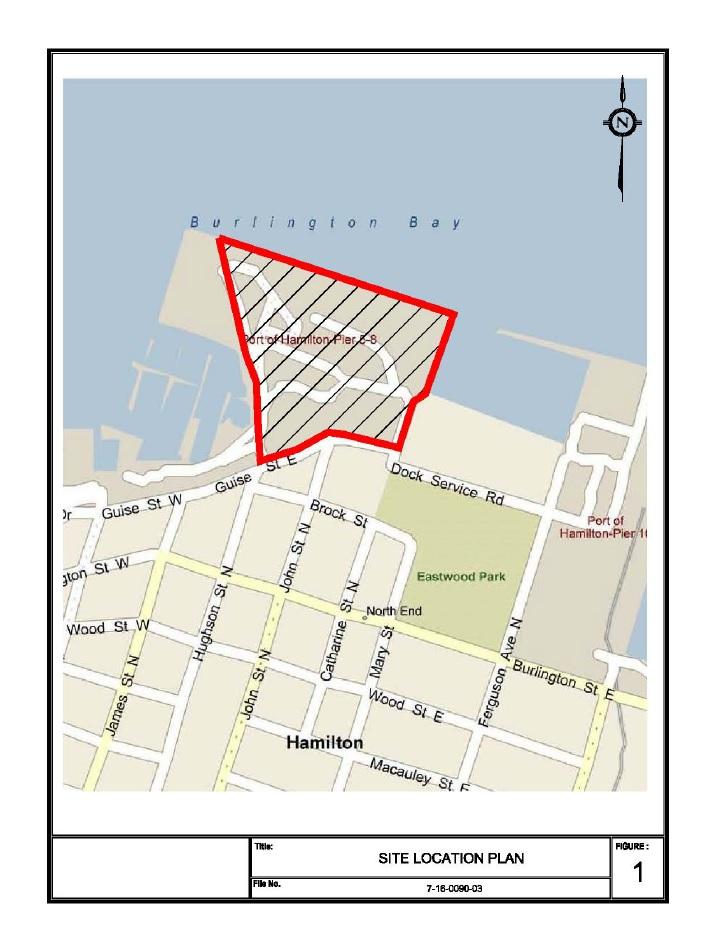
4 City of Hamilton Waterfront Development Office February, Re: Geotechnical Investigation - Pier Blocks File No INTRODUCTION This report presents the results of a preliminary geotechnical investigation carried out in the Pier area of the City of Hamilton. The location of the site is shown on Figure. The intent of the investigation was to provide factual information on the soil, rock and groundwater conditions on blocks that have been created in the Pier lands. The results of eight boreholes designated as Boreholes B to B that were drilled at the site are reported together with the results of soil classification testing carried out on selected samples. Also enclosed are records of a series of boreholes that were drilled to provide information for the design of underground services and other infrastructure for the redevelopment of the Pier lands (Appendix B). The results of these investigations are presented in the following reports: Terraprobe Inc. Report No. ---, entitled Geotechnical investigation Pier Pumping Station and Forcemain, Hamilton, Ontario, dated September, ; and Terraprobe Inc. Report No. ---, entitled Geotechnical investigation Pier Underground Servicing, Hamilton, Ontario, dated December,. Records of boreholes from the City s database that were previously drilled at the site for other design initiatives have also been included (Appendix C). It is understood that the factual information in this report is being made available to proponents for due diligence purposes, for use in assessing the feasibility of developing the blocks and for conceptual design purposes. It is noted that the information provided may not be of sufficient detail for the detailed design of building foundations or other intents. It is presumed that proponents will undertake additional or supplementary investigations as needed to support their site specific design initiatives. Terraprobe Inc Page
5 City of Hamilton Waterfront Development Office February, Re: Geotechnical Investigation - Pier Blocks File No BACKGROUND It is known that the much of the west harbour area was created by filling. The following brief account of the development of the subject lands has been paraphrased from Dillon s ESA report for the subject lands. The west harbour area is situated north of Guise Street East approximately between James Street North and Ferguson Street as shown on Figure. The area was initially developed in the mid-s and it is likely that fill was deposited in the south portion of the study area during that period. More aggressive filling took place in the s during which time the northern approximately two thirds of the site was reclaimed and Pier was constructed. These lands were subsequently developed for use primarily as warehousing. Later uses included boat storage and maintenance associated with the marina and yacht club, a ferry terminal, aircraft hangar and trucking terminal and continued use of the land for warehousing and shipyard use. Most of the buildings have been razed in and however building foundations and slabs on grade were left in place in most instances. Dillon Consulting ed: Phase Two Environmental Site Assessment, Pier, Hamilton, Ontario, Draft Report, April Terraprobe Inc Page
6 City of Hamilton Waterfront Development Office February, Re: Geotechnical Investigation - Pier Blocks File No PROCEDURE The fieldwork for the current investigation was carried out between January and January,, during which time boreholes numbered B to B were drilled as follows: Borehole Number Block No. B B B B B B B B The locations of the boreholes are shown on the Location Plan, Figure. The results of the current series of boreholes are shown on the Log of Borehole sheets in Appendix A of this report. The existing underground services at the site were located in advance of the drilling by Ontario One Call. In addition, Frontier Utility Locating Services Inc. was retained to confirm that there were no private services conflicting with the borehole locations. The drilling equipment consisted of a CME truck mounted drill rig that was supplied and operated by Geo-Environmental Drilling Inc. Members of our engineering staff arranged for the underground service locates, observed the drilling and sampling operations, logged the boreholes and cared for the samples obtained. The boreholes were advanced to a depth of m below the existing ground surface using conventional interval augering and sampling techniques. The boreholes were advanced from a depth of m to the depth explored using casing and mud rotary drilling techniques. Soil samples were recovered by split barrel sampling in accordance with ASTM Standard D at.m intervals to a nominal depth of m below the existing ground surface and at m intervals of depth thereafter. In-situ shear vane shear testing was carried out in the softer cohesive soils encountered. Terraprobe Inc Page
7 City of Hamilton Waterfront Development Office February, Re: Geotechnical Investigation - Pier Blocks File No. --- The boreholes were terminated at practical refusal which has been interpreted as coinciding with the surface of the weathered shale bedrock. No rock coring was carried out as part of the current program. It is noted that rock coring was carried out at selected locations during previous investigations and this information has been included in this report. Soil samples recovered from the boreholes were sealed in clean, single use containers and transferred to Terraprobe s Stoney Creek laboratory for further examination and laboratory testing. Soil cuttings from the boreholes were contained in sealed steel drums which were subsequently removed from the site and managed by a soil management contractor. The ground surface elevations at the borehole locations have been inferred from the spot elevations shown on topographical mapping provided by the City of Hamilton. The ground water conditions in the open boreholes were observed during and immediately after drilling. Ground water levels reported in monitoring wells constructed at the site previously have been reported. A program of geotechnical laboratory testing was carried out on the soil samples recovered from the boreholes including moisture content (ASTM D ), particle size analysis (ASTM D), and Atterburg s (ASTM D). The results of the laboratory testing are presented in Appendix D and are shown on the Records of Borehole sheets in Appendix A. No soil quality analyses were carried out as part of this investigation. Information on soil quality is available in various Environmental Site Assessment (ESA) reports by others. Terraprobe Inc Page
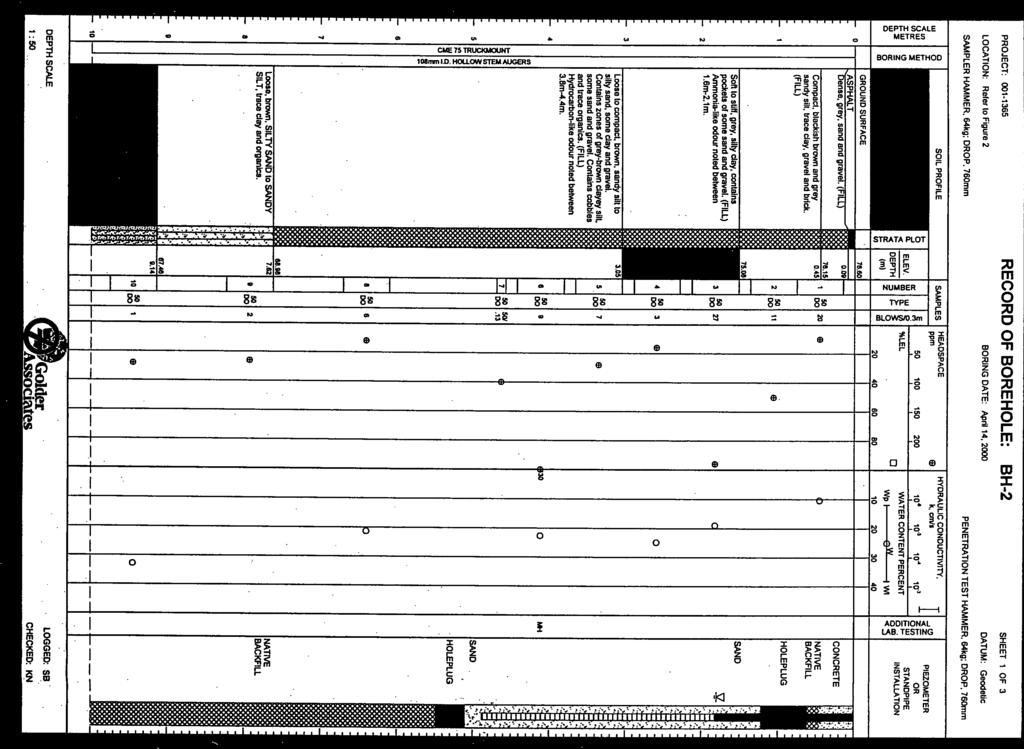
8 City of Hamilton Waterfront Development Office February, Re: Geotechnical Investigation - Pier Blocks File No SUBSURFACE CONDITIONS General The subsurface soil, rock and ground water conditions encountered in the boreholes drilled as part of the present investigation are shown on the Log of Boreholes sheets provided in the accompanying Appendix A. The results of boreholes previously drilled at the site for the design of underground services and other infrastructure are provided in Appendices B and C respectively. The subsurface conditions were confirmed at the borehole locations only and the conditions will vary between and beyond the boreholes. The boundaries between the various strata shown on the Record of Borehole sheets were based on non-continuous sampling and observations of drilling resistance. These boundaries typically represent a transition between the various stratigraphic units and are not to be interpreted as precise planes of stratigraphic change. The subsurface conditions encountered at the site generally consisted of fill overlying soft organic silt and very loose silt. The silt was underlain by stiff to very stiff silty clay. All of the boreholes were terminated at the depth of practical refusal which was presumed to correspond with the bedrock surface.. Soil Conditions The following is a general description of the major stratigraphic units encountered in the boreholes.... Fill Fill of a variable nature was encountered to depths of about to m below the existing ground surface in boreholes B to B. The fill generally consisted of silty sand and silty clay mixed with rubble consisting of gravel, pieces of concrete, brick, slag, timber and other materials. The N values determined in the Standard Penetration testing carried out in the fill ranged from to greater than blows per.m with an average N value of about blows per.m. It is considered likely that the highest N values observed were an indication of coarser sized particles encountered during drilling and do did not reflect the state of packing of the fill. It should be noted that large particle sizes such as construction rubble, slag and other obstructions were encountered within the fill stratum that overlies the site. Information as to the size and distribution of the coarse particles within the fill is not provided since the sampling equipment and techniques used were not of sufficient size to capture large particles. Terraprobe Inc Page
9 City of Hamilton Waterfront Development Office February, Re: Geotechnical Investigation - Pier Blocks File No. --- The high penetration resistance observed at some locations provides an indication of the likely presence of large sized particles in the fill. Test pits would be needed to provide further information on the make-up of the fill. The in-situ water content of samples of the fill recovered from the penetration testing ranged from about to percent with an average in-situ water content of about percent.... Silty Fine Sand Borehole penetrated a near surface layer of silty fine with an N value of blows per.m and a natural water content of about to percent.... Organic Silt and Silt Strata of organic silt and silt were encountered beneath the fill in most of the boreholes. The N values determined in the organic silt were in the range of to blows per.m inferring a relatively soft consistency. The in-situ water content of the organic silt ranged from about to percent with an average natural water content of about percent. The N values determined in the underlying silt ranged from to blows per.m. The water content of the silt ranged from about to percent. Grain size distribution curves for samples of the organic silt and silt are shown on Figure D in Appendix D.... Silty Clay A stratum of silty clay was encountered beneath the silt and organic silt in all of the boreholes. The N values determined in the silty clay were in the range of to blows per.m with an average N value of about blows per.m, inferring a stiff to very stiff consistency. The results of field vane strength testing carried out within the softer silty clay (i.e. N< blows per.m) ranged from about to greater than kpa, inferring a stiff consistency. Grain size distribution curves for selected samples of the silty clay recovered from the boreholes are shown on Figure D in Appendix D. Average liquid and plastic limits of about and percent respectively (average for six samples)were determined on the silty clay indicating inorganic clay of relatively low plasticity as shown on Figure D. Terraprobe Inc Page
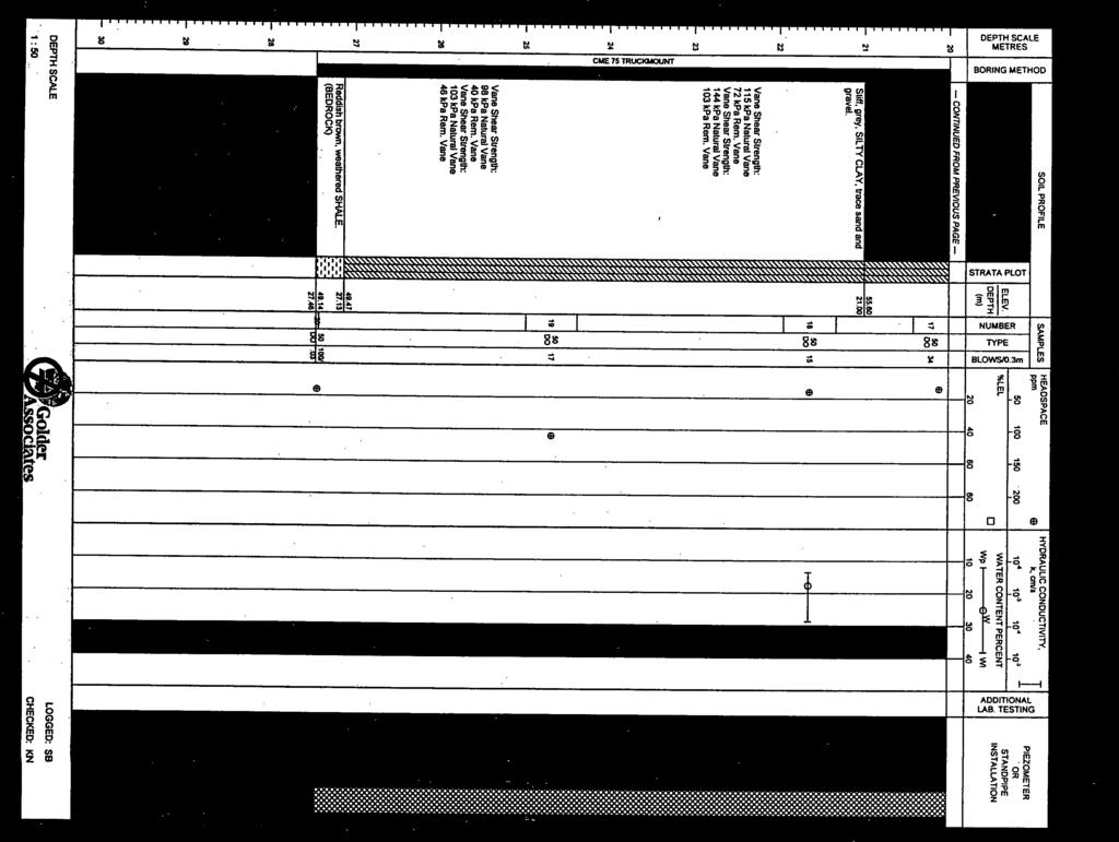
10 City of Hamilton Waterfront Development Office February, Re: Geotechnical Investigation - Pier Blocks File No Silty Clay Till A stratum of silty clay till was penetrated beneath the stiff silty clay in boreholes B, B, B, B and B. N values in the range of to blows per.m were determined in the silty clay till. The natural water content of the silty clay till ranged from about to percent.... Shaley Till Several of the boreholes penetrated a layer beneath the silty clay and silty clay till that has been identified as shaley till. This unit can generally be described, in geological terms, as an imbricate embedment of fragments of shale bedrock in a till matrix, and is thought to have been formed by glacial overriding of the parent bedrock. Based on the consistency and the relatively high penetration resistance, this stratum has often been interpreted as a highly weathered zone of the bedrock formation. It is typically difficult to distinguish the shaley till from the underlying weathered shale bedrock. N values of to greater than blows per.m were determined in the shaley till. The natural water content of the shaley till was in the range of about to percent.... Weathered Shale The interval sampling method used to explore the overburden at the site is conventionally accepted investigative practice however this method does not define the bedrock surface with precision particularly in this instance where the bedrock is overlain by glacial till with a similar make-up and where the surficial zone of the underlying bedrock is weathered. As best could be practically determined, the surface of the bedrock has been interpreted at the depths and elevations shown below. Borehole No. Apparent Depth to Bedrock Apparent Bedrock Surface Elevation B.. B.. B.. B.. B.. B.. B.. B.. Bedrock at the site of the proposed pumping station (Block ) was confirmed by rock coring during a previous investigation (BH Appendix B) at a depth of.m below ground Terraprobe Inc Page
11 City of Hamilton Waterfront Development Office February, Re: Geotechnical Investigation - Pier Blocks File No. --- surface or at elevation.m. Bedrock was reported in the area of the existing Discovery Centre (northwest area of Pier ) at a depth of about m or at Elevation.m (BH Golder - Appendix C). The bedrock that underlies the site belongs to the Queenston Formation which predominantly consists of thinly bedded reddish brown calcareous shale with grey green bands of interbedded argillaceous limestone. The shale is of relatively low strength and the harder limestone layers are of medium strength. A summary of other general information with respect to this formation is presented in the Ontario Ministry of Transportation and Communication publication RR - Evaluation of Shales for Construction Projects- An Ontario Shale Rating System, March... Ground Water Conditions The boreholes were drilled using mud rotary techniques and for this reason stabilized ground water conditions could not be determined in the open boreholes following drilling. Ground water was typically encountered at depth of about to m below the existing ground surface. The water level measured in the harbour at Pier at the time of the investigation was at elevation.m. The following is a summary of ground water levels measured in monitoring wells constructed in selected boreholes as part of the previous investigation (Appendix B). Borehole No. Screened Interval Summary of Ground Water Level Monitoring Soil Stratum Sept. Elevation of Ground Water Level Oct. Nov. July Feb.,.. silt... n/a.. silty clay... n/a.. silty clay silty clay.... n/a.. Fill.... n/a.. silt... n/a n/a.. sandy silt n/a n/a. n/a n/a n/a not accessible The ground water levels indicated above may not necessarily represent stabilized conditions. In addition the ground water levels will vary seasonally and with precipitation conditions. The corresponding water levels in Hamilton harbour during the field work (from Canada Fisheries and Oceans - Station, Burlington) are shown below. Terraprobe Inc Page
12 City of Hamilton Waterfront Development Office February, Re: Geotechnical Investigation - Pier Blocks File No. --- Summary of Lake Ontario Levels (Burlington) Date Sept., Oct., Nov., July, Water level (IGLD ).... Terraprobe Inc Page
13 City of Hamilton Waterfront Development Office February, Re: Geotechnical Investigation - Pier Blocks File No DISCUION Information on the subsurface soil and rock conditions encountered in boreholes drilled on various blocks in the Pier lands has been provided. The following discussion regarding future development of the Pier blocks is offered for planning and conceptual design consideration only and must be confirmed via a detailed geotechnical investigation at the design stage. It is intended that proponents will examine the factual results of the investigation and make their own interpretation of the data and assessment of the constraints and opportunities for future development at the site(s). The subsurface conditions at the site generally consisted of deep, variable deep fill deposits overlying strata of compressible organic silt and loose to very loose silt overlying stiff to very stiff silty clay. Refusal, presumed to correspond with the bedrock surface was encountered at depths of about to m below the existing ground surface. There are risks that are inherent to developing property underlain by fill. The primary concern relates to the potential for ongoing post construction differential settlement. Settlement will occur due to consolidation of the underlying soils due to the weight of the fill and within the fill mass due to the variability of the fill and the method of deposition. In this case the existing fill has been in place for some + years and the consolidation of the underlying native soil is expected to be essentially complete under the existing loading. It is considered that the risk of large settlements to take place would be low provided that there are not major grade raises. It was considered feasible to construct underground serving for the development based on this premise and provided that minor settlements could be tolerated. Buildings are less tolerant of post construction settlement and other approaches must therefore be considered for the development. Deep foundations generally consisting of end bearing units penetrating the bedrock that underlies the site are considered the preferred alternative due to the lowest risk and the highest load carrying capacity. In some instances use of raft foundations, possibly in conjunction with ground improvement techniques and/or pre-loading may be feasible to support low rise structures. Terraprobe Inc Page
14 City of Hamilton Waterfront Development Office February, Re: Geotechnical Investigation - Pier Blocks File No LIMITATIONS AND USE OF REPORT Procedures This investigation has been carried out using investigation techniques consistent with those ordinarily exercised by Terraprobe and other engineering practitioners, working under similar conditions and subject to the time, financial and physical constraints applicable to this project. The drilling and sampling was carried out by a specialist drilling contractor and observed and recorded by Terraprobe on a full time basis. The boreholes were advanced using mud rotary drilling techniques and sampling was carried out at regular intervals of depth. A Terraprobe technician logged the boreholes and examined the samples recovered from the boreholes. The samples were contained and transferred to the Terraprobe laboratory, where they were reviewed for consistency of description by a geotechnical engineer and classification testing was carried out on selected samples. Ground water observations were made in the boreholes as drilling proceeded. It is noted that the stratigraphic limits shown on the borehole logs are based on noncontinuous sampling and observations of drilling resistance and are therefore considered to be approximate and should not be interpreted as exact planes of geological change. It must be recognized that there are special risks whenever engineering or related disciplines are applied to identify subsurface conditions. A comprehensive sampling and testing programme implemented in accordance with the most stringent level of care may fail to detect certain conditions. It may not be possible to drill a sufficient number of boreholes, or sample and report them in a way that would provide all the subsurface information and geotechnical advice to completely identify all aspects of the site and works that could affect development costs, techniques, equipment and scheduling. Proponents must be directed to draw their own conclusions regarding the subsurface conditions and how these conditions could affect the feasibility of developing the various blocks. Terraprobe Inc Page

15 City of Hamilton Waterfront Development Office February, Re: Geotechnical Investigation - Pier Blocks File No Use of Report This is a preliminary geotechnical report that is intended for planning, conceptual design and due diligence purposes only. Additional boreholes, ground water monitoring wells, laboratory testing and detailed geotechnical analysis will be required at the detailed design stage. No warranty is made regarding the adequacy or completeness of the information for site specific design purposes. This report is copyright of Terraprobe Inc., and no part of this report may be reproduced by any means, in any form, without the prior written permission of Terraprobe. We trust that this report is satisfactory for your present requirements. If there is any point requiring further clarification, please contact the undersigned. Yours Truly Terraprobe Inc. J. G. Muckle, P. Eng., Associate Terraprobe Inc Page
16 FIGURES Terraprobe Inc.
17
18
19 LOGS OF BOREHOLES APPENDIX A Terraprobe Inc.
20 Terraprobe ABBREVIATIONS AND TERMINOLOGY SAMPLING METHODS PENETRATION RESISTANCE AS CORE DP FV GS ST WS auger sample cored sample direct push field vane grab sample split spoon shelby tube wash sample Standard Penetration Test (SPT) resistance ('N' values) is defined as the number of blows by a hammer weighing. kg ( lb.) falling freely for a distance of. m ( in.) required to advance a standard mm ( in.) diameter split spoon sampler for a distance of. m ( in.). Dynamic Cone Test (DCT) resistance is defined as the number of blows by a hammer weighing. kg ( lb.) falling freely for a distance of. m ( in.) required to advance a conical steel point of mm ( in.) diameter and with sides on 'A' size drill rods for a distance of. m ( in.)." COHESIONLE SOILS COHESIVE SOILS COMPOSITION Compactness N value Consistency N value Undrained Shear Strength (kpa) Term (e.g) % by weight very loose < loose compact dense very dense > very soft < < soft firm stiff very stiff hard > > trace silt < some silt silty sand and silt > TESTS AND SYMBOLS MH mechanical sieve and hydrometer analysis w, w c water content w L, LL liquid limit w P, PL plastic limit I P, PI plasticity index k coefficient of permeability γ soil unit weight, bulk φ internal friction angle c effective cohesion undrained shear strength c u C c c v m v e Unstabilized water level st water level measurement nd water level measurement Most recent water level measurement Undrained shear strength from field vane (with sensitivity) compression index coefficient of consolidation coefficient of compressibility void ratio FIELD MOISTURE DESCRIPTIONS Damp refers to a soil sample that does not exhibit any observable pore water from field/hand inspection. Moist refers to a soil sample that exhibits evidence of existing pore water (e.g. sample feels cool, cohesive soil is at plastic limit) but does not have visible pore water Wet refers to a soil sample that has visible pore water Terraprobe Inc. Greater Toronto Hamilton Niagara Central Ontario Northern Ontario Indell Lane Barton Street, Unit Bayview Drive, Unit Kelly Lake Rd., Unit Brampton, Ontario LT Y Stoney Creek, Ontario LE P Barrie, Ontario LN Y Sudbury, Ontario PE P () - Fax: - () - Fax: - () - Fax: - () - Fax: -
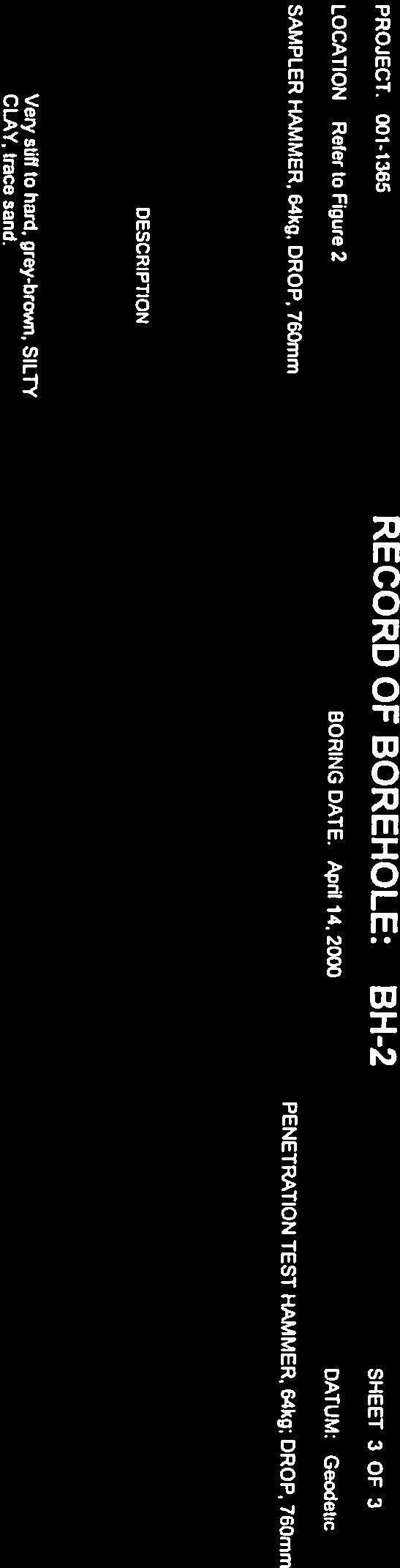
21 Project No. : --- Date started : January, Sheet No. : of Position : E:, N: (UTM T) Elevation Datum : Geodetic Rig type Depth Scale Elev Depth... : CME, truck-mounted GROUND SURFACE mm ASPHALTIC CONCRETE FILL, granular base SOIL PROFILE Description FILL, silty sand to sandy silt, with pieces of brick, timber, slag, concrete and gravel, very loose to compact, brownish black to grey Client Project Graphic Log Number Type : The City of Hamilton : Pier Blocks Location : Hamilton, Ontario SAMPLES Drilling Method SPT 'N' Value Elevation Scale : Tri-cone with casing (mud rotary) Penetration Test Values (Blows /.m) Dynamic Cone Undrained Shear Strength (kpa) Unconfined Field Vane Pocket Penetrometer Lab Vane LOG OF BOREHOLE B Plastic Moisture / Plasticity PL Natural Water Content MC LL Liquid Headspace Vapour (ppm) Originated by : AF Compiled by : GM Checked by : GM Instrument Details Unstabilized Water Level Lab Data and Comments GRAIN SIZE DISTRIBUTION (%) (MIT) GR SA SI CL.. ORGANIC SILT, soft, black / dark brown.. SILT, trace sand, trace organics, very loose to loose, dark brown / grey.. SILTY CLAY, trace gravel, very stiff, grey.. SILTY CLAY, trace sand, occasional gravel, hard, grey (GLACIAL TILL) file: pier blocks.gpj..... SHALEY TILL, reddish brown WEATHERED SHALE, reddish brown END OF BOREHOLE Auger refusal on inferred bedrock Borehole contained drill water upon completion of drilling. Unstabilized water level and cave not measured. / mm / mm
22 Project No. : --- Date started : January, Sheet No. : of Position : E:, N: (UTM T) Elevation Datum : Geodetic Rig type Depth Scale.. : CME, truck-mounted SOIL PROFILE Elev Depth Description. GROUND SURFACE mm ASPHALTIC CONCRETE FILL, silty sand and gravel, with pieces of brick and rubble, compact, brown FILL, sandy silt, trace clay, trace organics, pieces of asphalt, gravel, metal, brick and slag, loose to compact, brown Client Project Graphic Log Number Type : The City of Hamilton : Pier Blocks Location : Hamilton, Ontario SAMPLES Drilling Method SPT 'N' Value Elevation Scale : Tri-cone with casing (mud rotary) Penetration Test Values (Blows /.m) Dynamic Cone Undrained Shear Strength (kpa) Unconfined Field Vane Pocket Penetrometer Lab Vane LOG OF BOREHOLE B Plastic Moisture / Plasticity PL Natural Water Content MC LL Liquid Headspace Vapour (ppm) Originated by : JM Compiled by : GM Checked by : GM Instrument Details Unstabilized Water Level Lab Data and Comments GRAIN SIZE DISTRIBUTION (%) (MIT) GR SA SI CL.. SANDY SILT to SILT, trace shale fragments, trace organics, very loose, brown / grey.. SILTY CLAY, trace sand, trace gravel, stiff to hard, brown to grey SILT, trace clay, trace gravel, very dense, grey SHALEY TILL, hard, reddish brown WEATHERED SHALE, (probably), reddish brown / mm file: pier blocks.gpj END OF BOREHOLE Auger refusal on inferred bedrock Borehole contained drill water upon completion of drilling. Unstabilized water level and cave not measured.
23 Project No. : --- Date started : January, Sheet No. : of Position : E:, N: (UTM T) Elevation Datum : Geodetic Rig type Depth Scale Elev Depth : CME, truck-mounted GROUND SURFACE FILL, granular base FILL, silty sand and gravel, pieces of concrete and wood, dark brown TIMBER SOIL PROFILE Description FILL, Foundry sand, with pieces of slag, compact, black SANDY SILT, loose, grey SILT to ORGANIC SILT, soft, brown Client Project Graphic Log Number Type : The City of Hamilton : Pier Blocks Location : Hamilton, Ontario SAMPLES Drilling Method SPT 'N' Value Elevation Scale : Tri-cone with casing (mud rotary) Penetration Test Values (Blows /.m) Dynamic Cone Undrained Shear Strength (kpa) Unconfined Field Vane Pocket Penetrometer Lab Vane LOG OF BOREHOLE B Plastic Moisture / Plasticity PL Natural Water Content MC LL Liquid Headspace Vapour (ppm) Originated by : AF Compiled by : GM Checked by : GM Instrument Details Unstabilized Water Level Lab Data and Comments GRAIN SIZE DISTRIBUTION (%) (MIT) GR SA SI CL.. SILTY CLAY, trace sand, trace gravel, stiff to very stiff, grey.. SILTY CLAY, trace sand, occasional gravel, hard, grey (GLACIAL TILL) file: pier blocks.gpj..... SHALEY TILL, trace sand, occasional rock fragments, hard, reddish brown WEATHERED SHALE, reddish brown END OF BOREHOLE Auger refusal on inferred bedrock Borehole contained drill water upon completion of drilling. Unstabilized water level and cave not measured. / mm
24 Project No. : --- Date started : January, Sheet No. : of Position : E:, N: (UTM T) Elevation Datum : Geodetic Rig type Depth Scale : CME, truck-mounted SOIL PROFILE Elev Depth Description. GROUND SURFACE. mm ASPHALTIC CONCRETE. FILL, granular base FILL, rubble to sandy silt, with pieces of brick, mortar, concrete, timber, cinders, loose to compact, brown / black Client Project Graphic Log Number Type : The City of Hamilton : Pier Blocks Location : Hamilton, Ontario SAMPLES Drilling Method SPT 'N' Value / mm Elevation Scale : Tri-cone with casing (mud rotary) Penetration Test Values (Blows /.m) Dynamic Cone Undrained Shear Strength (kpa) Unconfined Field Vane Pocket Penetrometer Lab Vane LOG OF BOREHOLE B Plastic Moisture / Plasticity PL Natural Water Content MC LL Liquid Headspace Vapour (ppm) Originated by : AF Compiled by : GM Checked by : GM Instrument Details Unstabilized Water Level Lab Data and Comments GRAIN SIZE DISTRIBUTION (%) (MIT) GR SA SI CL.. FILL, silty clay, trace topsoil, soft, grey.. ORGANIC SILT, soft, black.. SILT, trace sand, loose, dark brown to grey.. SILTY CLAY, till like, very stiff, brown to grey.. SILTY CLAY, trace gravel, stiff, grey.. SILTY CLAY, trace sand, occasional gravel, grey (GLACIAL TILL) file: pier blocks.gpj... WEATHERED SHALE, reddish brown END OF BOREHOLE Auger refusal on inferred bedrock Borehole contained drill water upon completion of drilling. Unstabilized water level and cave not measured. / mm
25 Project No. : --- Date started : January, Sheet No. : of Position : E:, N: (UTM T) Elevation Datum : Geodetic Rig type Depth Scale Elev Depth. : CME, truck-mounted SOIL PROFILE Description GROUND SURFACE FILL, rubble with silty sand, with gravel, trace ash and cinders, with pieces of brick, mortar, concrete, timber, very loose to compact, blackish brown and grey Client Project Graphic Log Number Type : The City of Hamilton : Pier Blocks Location : Hamilton, Ontario SAMPLES Drilling Method SPT 'N' Value Elevation Scale : Tri-cone with casing (mud rotary) Penetration Test Values (Blows /.m) Dynamic Cone Undrained Shear Strength (kpa) Unconfined Field Vane Pocket Penetrometer Lab Vane LOG OF BOREHOLE B Plastic Moisture / Plasticity PL Natural Water Content MC LL Liquid Headspace Vapour (ppm) Originated by : AF Compiled by : GM Checked by : GM Instrument Details Unstabilized Water Level Lab Data and Comments GRAIN SIZE DISTRIBUTION (%) (MIT) GR SA SI CL.. ORGANIC SILT, very soft, grey.... SILT, trace fine sand, very loose, brown SILTY CLAY, trace gravel, stiff, grey FV FV.. file: pier blocks.gpj..... SILT, trace clay, trace fine sand, dense, grey WEATHERED SHALE, reddish brown END OF BOREHOLE Auger refusal on inferred bedrock Borehole contained drill water upon completion of drilling. Unstabilized water level and cave not measured. FV / mm.
26 Project No. : --- Date started : January, Sheet No. : of Position : E:, N: (UTM T) Elevation Datum : Geodetic Rig type Depth Scale Elev Depth... : CME, truck-mounted GROUND SURFACE FILL, granular SOIL PROFILE Description FILL, silty fine sand, with layers of peat and silt, very stiff to compact, brown Client Project Graphic Log Number Type : The City of Hamilton : Pier Blocks Location : Hamilton, Ontario SAMPLES Drilling Method SPT 'N' Value Elevation Scale : Tri-cone with casing (mud rotary) Penetration Test Values (Blows /.m) Dynamic Cone Undrained Shear Strength (kpa) Unconfined Field Vane Pocket Penetrometer Lab Vane LOG OF BOREHOLE B Plastic Moisture / Plasticity PL Natural Water Content MC LL Liquid Headspace Vapour (ppm) Originated by : SG Compiled by : GM Checked by : GM Instrument Details Unstabilized Water Level Lab Data and Comments GRAIN SIZE DISTRIBUTION (%) (MIT) GR SA SI CL.. ORGANIC SILT to SILT, with shale fragments, very soft, brown to grey.. SILTY CLAY, trace sand, trace gravel, stiff, grey FV.. SILTY CLAY, very stiff, grey (GLACIAL TILL) file: pier blocks.gpj.... SHALEY TILL, hard, reddish brown END OF BOREHOLE Auger refusal on inferred bedrock Borehole contained drill water upon completion of drilling. Unstabilized water level and cave not measured. / mm
27 file: pier blocks.gpj Project No. : --- Date started : January, Sheet No. : of Position : E:, N: (UTM T) Elevation Datum : Geodetic Rig type Depth Scale Elev Depth : CME, truck-mounted SOIL PROFILE Description GROUND SURFACE FILL, sand and gravel, trace silt, trace clay, black / brown FILL, clayey silt and topsoil, with gravel, pieces of timber brick and glass fragments, firm to stiff, brown / black ORGANIC SILT to SILT, trace shale fragments, trace fine sand, very soft to soft, dark brown to grey...timber penetrated at.m depth SILTY CLAY, stiff, grey SILTY CLAY, trace sand, occasional gravel, hard, grey (GLACIAL TILL) WEATHERED SHALE, reddish brown END OF BOREHOLE Auger refusal on inferred bedrock Borehole contained drill water upon completion of drilling. Unstabilized water level and cave not measured. Client Project Graphic Log Number Type : The City of Hamilton : Pier Blocks Location : Hamilton, Ontario SAMPLES FV FV FV Drilling Method SPT 'N' Value / mm Elevation Scale : Tri-cone with casing (mud rotary) Penetration Test Values (Blows /.m) Dynamic Cone Undrained Shear Strength (kpa) Unconfined Field Vane Pocket Penetrometer Lab Vane... LOG OF BOREHOLE B Plastic Moisture / Plasticity PL Natural Water Content MC LL Liquid Headspace Vapour (ppm) Originated by : SG Compiled by : GM Checked by : GM Instrument Details Unstabilized Water Level Lab Data and Comments GRAIN SIZE DISTRIBUTION (%) (MIT) GR SA SI CL
28 file: pier blocks.gpj Project No. : --- Date started : January, Sheet No. : of Position : E:, N: (UTM T) Elevation Datum : Geodetic Rig type Depth Scale Elev Depth : CME, truck-mounted GROUND SURFACE mm TOPSOIL SOIL PROFILE Description SILTY FINE SAND, very loose, brown SANDY SILT, compact, grey SILTY CLAY, trace sand, trace gravel, stiff, grey...becoming till like at.m depth SILT, trace sand, trace clay, dense, grey SHALEY TILL, hard, reddish brown WEATHERED SHALE, reddish brown END OF BOREHOLE Auger refusal on inferred bedrock Borehole contained drill water upon completion of drilling. Unstabilized water level and cave not measured. Client Project Graphic Log Number Type : The City of Hamilton : Pier Blocks Location : Hamilton, Ontario SAMPLES FV FV Drilling Method SPT 'N' Value / mm Elevation Scale : Tri-cone with casing (mud rotary) Penetration Test Values (Blows /.m) Dynamic Cone Undrained Shear Strength (kpa) Unconfined Field Vane Pocket Penetrometer Lab Vane.. LOG OF BOREHOLE B Plastic Moisture / Plasticity PL Natural Water Content MC LL Liquid Headspace Vapour (ppm) Originated by : JM Compiled by : GM Checked by : GM Instrument Details Unstabilized Water Level Lab Data and Comments GRAIN SIZE DISTRIBUTION (%) (MIT) GR SA SI CL
29 LOGS OF BOREHOLES PIER UNDERGROUND SERVICES APPENDIX B Terraprobe Inc.
30 Project No. : --- Date started : August, Sheet No. : of Position : E:, N: (UTM T) Depth Scale Elev Depth SOIL PROFILE Description. GROUND SURFACE FILL Granular Base Client Project : Pier Graphic Log Number Type : The City of Hamilton Location : Hamilton, Ontario SAMPLES Elevation Datum SPT 'N' Value Elevation Scale : Geodetic (NAD) Rig type : D, truck-mounted Drilling Method : Solid stem augers Penetration Test Values (Blows /.m) Dynamic Cone Undrained Shear Strength (kpa) Unconfined Field Vane Pocket Penetrometer Lab Vane Plastic LOG OF BOREHOLE Moisture / Plasticity PL Natural Water Content MC LL Liquid Headspace Vapour (ppm) Originated by : AF Compiled by : GM Instrument Details Checked by : GM Unstabilized Water Level Lab Data and Comments GRAIN SIZE DISTRIBUTION (%) (MIT) GR SA SI CL.. FILL, silty sand, some gravel, with pieces of concrete and brick, compact.. FILL, silty sand, some gravel, with pieces of concrete and brick, compact.. SILTY CLAY, with silt seams and layers, stiff, grey.. END OF BOREHOLE Unstabilized water level measured at. m below ground surface; borehole was open upon completion of drilling. file: --- pier hamilton.gpj
31 Project No. : --- Date started : August, Sheet No. : of Position : E:, N: (UTM T) Depth Scale Elev Depth.. SOIL PROFILE Description. GROUND SURFACE FILL Granular Base FILL, clayey silt to sandy silt, with glass fragments and pieces of asphalt, gravel, loose, brown Client Project : Pier Graphic Log Number Type : The City of Hamilton Location : Hamilton, Ontario SAMPLES Elevation Datum SPT 'N' Value Elevation Scale : Geodetic (NAD) Rig type : D, truck-mounted Drilling Method : Solid stem augers Penetration Test Values (Blows /.m) Dynamic Cone Undrained Shear Strength (kpa) Unconfined Field Vane Pocket Penetrometer Lab Vane Plastic LOG OF BOREHOLE Moisture / Plasticity PL Natural Water Content MC LL Liquid Headspace Vapour (ppm) Originated by : AF Compiled by : GM Instrument Details Checked by : GM Unstabilized Water Level Lab Data and Comments GRAIN SIZE DISTRIBUTION (%) (MIT) GR SA SI CL.. ORGANIC SILT, shell fragments, very soft, dark grey WH WH WH.. SILTY CLAY, soft FV. file: --- pier hamilton.gpj.. END OF BOREHOLE Water encountered at m depth. Unstablized water level at.m below ground surface after drilling; borehole was open upon completion of drilling. mm dia. monitoring well installed. FV. WATER LEVEL READINGS Date Water Depth Elevation Sep,.. Oct,.. Nov,..
32 Project No. : --- Date started : August, Sheet No. : of Position : E:, N: (UTM T) Depth Scale Elev Depth. SOIL PROFILE Description GROUND SURFACE FILL, clayey silt, some sand, some shale fragments, pieces of slag, loose to compact, reddish brown Client Project : Pier Graphic Log Number Type : The City of Hamilton Location : Hamilton, Ontario SAMPLES Elevation Datum SPT 'N' Value Elevation Scale : Geodetic (NAD) Rig type : D, truck-mounted Drilling Method : Solid stem augers Penetration Test Values (Blows /.m) Dynamic Cone Undrained Shear Strength (kpa) Unconfined Field Vane Pocket Penetrometer Lab Vane Plastic LOG OF BOREHOLE Moisture / Plasticity PL Natural Water Content MC LL Liquid Headspace Vapour (ppm) Originated by : AF Compiled by : GM Instrument Details Checked by : GM Unstabilized Water Level Lab Data and Comments GRAIN SIZE DISTRIBUTION (%) (MIT) GR SA SI CL.. ORGANIC SILT, (poor recovery), very soft WH WH.. SANDY SILT to SILTY FINE SAND, very loose, grey WH WH.. SILTY CLAY, trace gravel, firm, grey FV. FV. FV. file: --- pier hamilton.gpj.. END OF BOREHOLE Water encountered at m depth. Unstablized water level at.m below ground surface after drilling; borehole was open upon completion of drilling. mm dia. monitoring well installed. WATER LEVEL READINGS Date Water Depth Elevation Sep,.. Oct,.. Nov,..
33 Project No. : --- Date started : August, Sheet No. : of Position : E:, N: (UTM T) Depth Scale Elev Depth.. FILL Granular Base SOIL PROFILE Description. GROUND SURFACE mm ASPHALTIC CONCRETE FILL, silty sand and gravel, some clay, pieces of slag, glass fragments and cinders, compact, dark brown / black Client Project : Pier Graphic Log Number Type : The City of Hamilton Location : Hamilton, Ontario SAMPLES Elevation Datum SPT 'N' Value Elevation Scale : Geodetic (NAD) Rig type : D, truck-mounted Drilling Method : Solid stem augers Penetration Test Values (Blows /.m) Dynamic Cone Undrained Shear Strength (kpa) Unconfined Field Vane Pocket Penetrometer Lab Vane Plastic LOG OF BOREHOLE Moisture / Plasticity PL Natural Water Content MC LL Liquid Headspace Vapour (ppm) Originated by : AF Compiled by : GM Instrument Details Checked by : GM Unstabilized Water Level Lab Data and Comments GRAIN SIZE DISTRIBUTION (%) (MIT) GR SA SI CL.. FILL, clayey silt to sandy silt, trace cinders, pieces of brick fragments, very loose to compact, dark brown.. ORGANIC SILT, soft, black.. SILT, trace sand, loose, dark grey.. END OF BOREHOLE Unstabilized water level measured at. m below ground surface; borehole was open upon completion of drilling. file: --- pier hamilton.gpj
34 Project No. : --- Date started : August, Sheet No. : of Position : E:, N: (UTM T) Depth Scale Elev Depth.. FILL Granular Base SOIL PROFILE Description. GROUND SURFACE mm ASPHALTIC CONCRETE FILL, sand, (possibly foundry sand) with brick fragments and clay lumps, compact, black Client Project : Pier Graphic Log Number Type : The City of Hamilton Location : Hamilton, Ontario SAMPLES Elevation Datum SPT 'N' Value Elevation Scale : Geodetic (NAD) Rig type : D, truck-mounted Drilling Method : Solid stem augers Penetration Test Values (Blows /.m) Dynamic Cone Undrained Shear Strength (kpa) Unconfined Field Vane Pocket Penetrometer Lab Vane Plastic LOG OF BOREHOLE Moisture / Plasticity PL Natural Water Content MC LL Liquid Headspace Vapour (ppm) Originated by : AF Compiled by : GM Instrument Details Checked by : GM Unstabilized Water Level Lab Data and Comments GRAIN SIZE DISTRIBUTION (%) (MIT) GR SA SI CL.. FILL, clayey silt, some gravel, some brick fragments, firm to stiff, dark brown.. ORGANIC SILT, very soft to soft, black.. SILT, trace sand, loose, dark grey.. END OF BOREHOLE Unstabilized water level measured at. m below ground surface; borehole was open upon completion of drilling. file: --- pier hamilton.gpj
35 Project No. : --- Date started : August, Sheet No. : of Position : E:, N: (UTM T) Depth Scale Elev Depth.... SOIL PROFILE Description. GROUND SURFACE. mm ASPHALTIC CONCRETE. FILL Granular Base FILL, clayey silt to sandy silt, with pieces of brick, dark brown to reddish brown FILL TAR, (solid), Black FILL, sandy silt, with layers of brown and black slag, pieces of concrete and asphalt, loose, brown and black Client Project : Pier Graphic Log Number Type : The City of Hamilton Location : Hamilton, Ontario SAMPLES Elevation Datum SPT 'N' Value Elevation Scale : Geodetic (NAD) Rig type : CME, truck-mounted Drilling Method : Hollow stem augers Penetration Test Values (Blows /.m) Dynamic Cone Undrained Shear Strength (kpa) Unconfined Field Vane Pocket Penetrometer Lab Vane LOG OF BOREHOLE Plastic Moisture / Plasticity PL Natural Water Content MC LL Liquid Headspace Vapour (ppm) Originated by : AF Compiled by : GM Instrument Details Checked by : GM Unstabilized Water Level Lab Data and Comments GRAIN SIZE DISTRIBUTION (%) (MIT) GR SA SI CL.. SILTY FINE SAND to SANDY SILT, very loose, dark brown to dark grey.. SILTY CLAY, trace gravel, stiff to very stiff, grey file: --- pier hamilton.gpj.. END OF BOREHOLE Unstabilized water level measured at. m below ground surface; borehole was open upon completion of drilling. mm dia. monitoring well installed. WATER LEVEL READINGS Date Water Depth Elevation Sep,.. Oct,.. Nov,.. Jul,..
36 Project No. : --- Date started : August, Sheet No. : of Position : E:, N: (UTM T) Depth Scale Elev Depth.. FILL Granular Base SOIL PROFILE Description. GROUND SURFACE mm ASPHALTIC CONCRETE FILL, silty clay, trace gravel, pieces of bick, very soft to firm, grey Client Project : Pier Graphic Log Number Type : The City of Hamilton Location : Hamilton, Ontario SAMPLES Elevation Datum SPT 'N' Value Elevation Scale : Geodetic (NAD) Rig type : CME, truck-mounted Drilling Method : Hollow stem augers Penetration Test Values (Blows /.m) Dynamic Cone Undrained Shear Strength (kpa) Unconfined Field Vane Pocket Penetrometer Lab Vane LOG OF BOREHOLE Plastic Moisture / Plasticity PL Natural Water Content MC LL Liquid Headspace Vapour (ppm) Originated by : AF Compiled by : GM Instrument Details Checked by : GM Unstabilized Water Level Lab Data and Comments GRAIN SIZE DISTRIBUTION (%) (MIT) GR SA SI CL.. FILL, clayey silt to sandy silt, with pieces of brick and mortar, loose to compact, dark brown to reddish brown.. SANDY SILT to SILTY FINE SAND, loose, dark grey file: --- pier hamilton.gpj.. END OF BOREHOLE Unstabilized water level measured at. m below ground surface; borehole was open upon completion of drilling. mm dia. monitoring well installed. WATER LEVEL READINGS Date Water Depth Elevation Sep,.. Oct,.. Nov,.. Jul,..
37 Project No. : --- Date started : August, Sheet No. : of Position : E:, N: (UTM T) Depth Scale Elev Depth.. SOIL PROFILE Description. GROUND SURFACE. mm ASPHALTIC CONCRETE. FILL Granular Base FILL, silty fine sand and gravel, pieces of asphalt, timber and metal, compact, brown / black FILL, brick fragments, some sand, mortar and rubble, loose to compact Client Project : Pier Graphic Log Number Type : The City of Hamilton Location : Hamilton, Ontario SAMPLES Elevation Datum SPT 'N' Value Elevation Scale : Geodetic (NAD) Rig type : D, truck-mounted Drilling Method : Solid stem augers Penetration Test Values (Blows /.m) Dynamic Cone Undrained Shear Strength (kpa) Unconfined Field Vane Pocket Penetrometer Lab Vane LOG OF BOREHOLE Plastic Moisture / Plasticity PL Natural Water Content MC LL Liquid Headspace Vapour (ppm) Originated by : AF Compiled by : GM Instrument Details Checked by : GM Unstabilized Water Level Lab Data and Comments GRAIN SIZE DISTRIBUTION (%) (MIT) GR SA SI CL.. FILL, silty fine sand, with pieces of brick, loose, dark brown to black.. SANDY SILT to SILTY FINE SAND, very loose to loose, dark grey.. END OF BOREHOLE file: --- pier hamilton.gpj Unstabilized water level measured at. m below ground surface; borehole was open upon completion of drilling.
38 Project No. : --- Date started : August, Sheet No. : of Position : E:, N: (UTM T) Depth Scale Elev Depth.. FILL Granular Base SOIL PROFILE Description. GROUND SURFACE mm ASPHALTIC CONCRETE FILL, sandy silt, with pieces of brick and slag, loose, dark brown Client Project : Pier Graphic Log Number Type : The City of Hamilton Location : Hamilton, Ontario SAMPLES Elevation Datum SPT 'N' Value Elevation Scale : Geodetic (NAD) Rig type : D, truck-mounted Drilling Method : Solid stem augers Penetration Test Values (Blows /.m) Dynamic Cone Undrained Shear Strength (kpa) Unconfined Field Vane Pocket Penetrometer Lab Vane LOG OF BOREHOLE Plastic Moisture / Plasticity PL Natural Water Content MC LL Liquid Headspace Vapour (ppm) Originated by : AF Compiled by : GM Instrument Details Checked by : GM Unstabilized Water Level Lab Data and Comments GRAIN SIZE DISTRIBUTION (%) (MIT) GR SA SI CL.. FILL, brick fragments and slag, some sand and gravel, compact.. FILL, silty fine sand, with pieces of concrete, very loose, brown.. SILTY FINE SAND to SANDY SILT, loose, grey.. END OF BOREHOLE Unstabilized water level measured at. m below ground surface; borehole was open upon completion of drilling. file: --- pier hamilton.gpj
39 Project No. : --- Date started : August, Sheet No. : of Position : E:, N: (UTM T) Depth Scale Elev Depth.. FILL Granular Base SOIL PROFILE Description. GROUND SURFACE mm ASPHALTIC CONCRETE FILL, sandy silt to clayey silt, with pieces of brick and slag, loose Client Project : Pier Graphic Log Number Type : The City of Hamilton Location : Hamilton, Ontario SAMPLES Elevation Datum SPT 'N' Value Elevation Scale : Geodetic (NAD) Rig type : D, truck-mounted Drilling Method : Solid stem augers Penetration Test Values (Blows /.m) Dynamic Cone Undrained Shear Strength (kpa) Unconfined Field Vane Pocket Penetrometer Lab Vane LOG OF BOREHOLE Plastic Moisture / Plasticity PL Natural Water Content MC LL Liquid Headspace Vapour (ppm) Originated by : AF Compiled by : GM Instrument Details Checked by : GM Unstabilized Water Level Lab Data and Comments GRAIN SIZE DISTRIBUTION (%) (MIT) GR SA SI CL.. FILL, slag and brick fragments, very dense to compact, black and brown / mm.. FILL, silty clay to clayey silt, with pieces of concrete, some sand and gravel, stiff, grey.. END OF BOREHOLE Unstabilized water level measured at. m below ground surface; borehole was open upon completion of drilling. file: --- pier hamilton.gpj
40 Project No. : --- Date started : August, Sheet No. : of Position : E:, N: (UTM T) Depth Scale Elev Depth SOIL PROFILE Description. GROUND SURFACE mm ASPHALTIC CONCRETE FILL, sandy silt, trace to some gravel, with pieces of asphlat and brick, dense, dark brown to black Client Project : Pier Graphic Log Number Type : The City of Hamilton Location : Hamilton, Ontario SAMPLES Elevation Datum SPT 'N' Value Elevation Scale : Geodetic (NAD) Rig type : D, truck-mounted Drilling Method : Solid stem augers Penetration Test Values (Blows /.m) Dynamic Cone Undrained Shear Strength (kpa) Unconfined Field Vane Pocket Penetrometer Lab Vane LOG OF BOREHOLE Plastic Moisture / Plasticity PL Natural Water Content MC LL Liquid Headspace Vapour (ppm) Originated by : AF Compiled by : GM Instrument Details Checked by : GM Unstabilized Water Level Lab Data and Comments GRAIN SIZE DISTRIBUTION (%) (MIT) GR SA SI CL / mm.. FILL, silty clay, trace topsoil, some gravel, firm, dark brown.. FILL, brick fragments, trace clay, rubble, compact, dark brown.. FILL, silty silt, some gravel, with pieces of brick and asphalt, compact, dark brown.. END OF BOREHOLE Unstabilized water level measured at. m below ground surface; borehole was open upon completion of drilling. file: --- pier hamilton.gpj
41 Project No. : --- Date started : August, Sheet No. : of Position : E:, N: (UTM T) Depth Scale Elev Depth SOIL PROFILE Description. GROUND SURFACE mm ASPHALTIC CONCRETE FILL, silty sand and gravel, trace cinders, pieces of concrete, wood, loose to compact, dark brown Client Project : Pier Graphic Log Number Type : The City of Hamilton Location : Hamilton, Ontario SAMPLES Elevation Datum SPT 'N' Value Elevation Scale : Geodetic (NAD) Rig type : D, truck-mounted Drilling Method : Solid stem augers Penetration Test Values (Blows /.m) Dynamic Cone Undrained Shear Strength (kpa) Unconfined Field Vane Pocket Penetrometer Lab Vane LOG OF BOREHOLE Plastic Moisture / Plasticity PL Natural Water Content MC LL Liquid Headspace Vapour (ppm) Originated by : AF Compiled by : GM Instrument Details Checked by : GM Unstabilized Water Level Lab Data and Comments GRAIN SIZE DISTRIBUTION (%) (MIT) GR SA SI CL.. FILL, clayey silt, some gravel, with pieces of brick and asphalt, loose to compact, dark brown.. FILL, slag with brick fragments.. END OF BOREHOLE / mm Unstabilized water level measured at. m below ground surface; borehole was open upon completion of drilling. file: --- pier hamilton.gpj
42 Project No. : --- Date started : August, Sheet No. : of Position : E:, N: (UTM T) Depth Scale Elev Depth SOIL PROFILE Description. GROUND SURFACE FILL Granular Base Client Project : Pier Graphic Log Number Type : The City of Hamilton Location : Hamilton, Ontario SAMPLES Elevation Datum SPT 'N' Value Elevation Scale : Geodetic (NAD) Rig type : D, truck-mounted Drilling Method : Solid stem augers Penetration Test Values (Blows /.m) Dynamic Cone Undrained Shear Strength (kpa) Unconfined Field Vane Pocket Penetrometer Lab Vane LOG OF BOREHOLE Plastic Moisture / Plasticity PL Natural Water Content MC LL Liquid Headspace Vapour (ppm) Originated by : AF Compiled by : GM Instrument Details Checked by : GM Unstabilized Water Level Lab Data and Comments GRAIN SIZE DISTRIBUTION (%) (MIT) GR SA SI CL.. FILL, sandy silt, trace clay, with pieces of brick, asphalt and timber, very loose to compact, dark brown to black.. SILTY FINE SAND to SANDY SILT, very loose, dark grey.. END OF BOREHOLE Unstabilized water level measured at. m below ground surface; borehole was open upon completion of drilling. file: --- pier hamilton.gpj
43 Project No. : --- Date started : August, Sheet No. : of Position : E:, N: (UTM T) Depth Scale Elev Depth SOIL PROFILE Description. GROUND SURFACE FILL Granular Base Client Project : Pier Graphic Log Number Type : The City of Hamilton Location : Hamilton, Ontario SAMPLES Elevation Datum SPT 'N' Value Elevation Scale : Geodetic (NAD) Rig type : D, truck-mounted Drilling Method : Solid stem augers Penetration Test Values (Blows /.m) Dynamic Cone Undrained Shear Strength (kpa) Unconfined Field Vane Pocket Penetrometer Lab Vane LOG OF BOREHOLE Plastic Moisture / Plasticity PL Natural Water Content MC LL Liquid Headspace Vapour (ppm) Originated by : AF Compiled by : GM Instrument Details Checked by : GM Unstabilized Water Level Lab Data and Comments GRAIN SIZE DISTRIBUTION (%) (MIT) GR SA SI CL.. FILL, silty sand to sandy silt, trace clay, with pieces of asphalt, gravel and timber, loose to compact, dark brown.. FILL, clayey silt, some gravel, with pieces of asphalt, soft, dark brown.. SILTY FINE SAND to SANDY SILT, loose to compact, dark grey.. END OF BOREHOLE Unstabilized water level measured at. m below ground surface; borehole was open upon completion of drilling. file: --- pier hamilton.gpj
44 Project No. : --- Date started : August, Sheet No. : of Position : E:, N: (UTM T) Depth Scale Elev Depth FILL Granular Base SOIL PROFILE Description. GROUND SURFACE mm ASPHALTIC CONCRETE Client Project : Pier Graphic Log Number Type : The City of Hamilton Location : Hamilton, Ontario SAMPLES Elevation Datum SPT 'N' Value Elevation Scale : Geodetic (NAD) Rig type : CME, truck-mounted Drilling Method : Hollow stem augers Penetration Test Values (Blows /.m) Dynamic Cone Undrained Shear Strength (kpa) Unconfined Field Vane Pocket Penetrometer Lab Vane LOG OF BOREHOLE Plastic Moisture / Plasticity PL Natural Water Content MC LL Liquid Headspace Vapour (ppm) Originated by : AF Compiled by : GM Instrument Details Checked by : GM Unstabilized Water Level Lab Data and Comments GRAIN SIZE DISTRIBUTION (%) (MIT) GR SA SI CL.. FILL, sandy silt, occasional gravel, loose, brown.. ORGANIC SILT, (possibly fill), soft, black / brown.. PEAT, soft, black.. SILT, very loose, brown.. CLAYEY SILT, with silt sayers, stiff, grey.. END OF BOREHOLE Unstabilized water level measured at. m below ground surface; borehole was open upon completion of drilling. WATER LEVEL READINGS Date Water Depth Elevation Sep,.. Oct,.. Nov,.. file: --- pier hamilton.gpj mm dia. monitoring well installed.
45 file: --- pier hamilton.gpj Project No. : --- Date started : October, Sheet No. : of Position : E:, N: (UTM T) Depth Scale Elev Depth GROUND SURFACE mm ASPHALTIC CONCRETE FILL Granular Base SOIL PROFILE Description FILL, silty fine sand and gravel, pieces of asphalt, timber and metal, compact, brown / black FILL, brick fragments, some sand, mortar and rubble, loose to compact FILL, silty fine sand, with pieces of brick, loose, dark brown to black SANDY SILT to SILTY FINE SAND, very loose to loose, dark grey...(see BH for upper m) SILTY FINE SAND, loose, grey ORGANIC SILT, stiff, grey SILTY CLAY, trace gravel, stiff to very stiff, grey SHALEY TILL, with grey silt layers, hard, reddish brown WEATHERED SHALE, reddish brown (QUEENSTON FORMATION) QUEENSTON FORMATION (See rock core log for details) END OF BOREHOLE Refusal on inferred bedrock Unstabilized water level measured at. m below ground surface; borehole caved to. m below ground surface upon completion of drilling. mm dia. monitoring well installed. Client Project : Pier Graphic Log Number Type : The City of Hamilton Location : Hamilton, Ontario SAMPLES RUN RUN Elevation Datum SPT 'N' Value / mm Elevation Scale : Geodetic (NAD) Rig type : CME, truck-mounted Drilling Method : Solid stem augers Penetration Test Values (Blows /.m) Dynamic Cone Undrained Shear Strength (kpa) Unconfined Field Vane Pocket Penetrometer Lab Vane LOG OF BOREHOLE Plastic Moisture / Plasticity WATER LEVEL READINGS Date Water Depth Elevation Nov,.. PL Natural Water Content MC LL Liquid Headspace Vapour (ppm) Originated by : AF Compiled by : GM Instrument Details Checked by : GM Unstabilized Water Level Lab Data and Comments GRAIN SIZE DISTRIBUTION (%) (MIT) GR SA SI CL
46 Project No. : --- Date started : October, Sheet No. : of Position : E:, N: (UTM T) Rig type : CME, truck-mounted Client : The City of Hamilton Project : Pier Location : Hamilton, Ontario Elevation Datum : Geodetic (NAD) Drilling Method : Solid stem augers ROCK CORE LOG Originated by : AF Compiled by : GM Checked by : GM Depth Graphic Log GENERAL DESCRIPTION Rock coring started at.m below grade QUEENSTON FORMATION Shale, reddish brown, thickly bedded to medium bedded, weak to medium strong, Limestone (%), grey green interbeds, bedding normally to mm with isolated beds of up to mm, weak to medium strength Run Elev Depth.. R Recovery TCR = % SCR = % RQD = % Elevation Z Shale Weathering Zones Z Z Z R Natural UCS (MPa) Fractures Laboratory Comments Testing Estimated Strength R R R R R Frequency Spacing close Elevation...m to.m: UCS =. MPa.-.m: Sub-vertical Fracture R TCR = % SCR = % RQD = % mod. close.m to.m: UCS =. MPa END OF COREHOLE..m file: --- pier hamilton.gpj
47 Project No. : --- Date started : June, Sheet No. : of Position : E:, N: (UTM T) Depth Scale Elev Depth.. mm Concrete SOIL PROFILE Description. GROUND SURFACE mm ASPHALTIC CONCRETE FILL, construction debris, pieces of brick, asphalt, slag, ceramics, very loose, brownish black Client Project : Pier Graphic Log Number Type : The City of Hamilton Location : Hamilton, Ontario SAMPLES Elevation Datum SPT 'N' Value Elevation Scale : Geodetic (NAD) Rig type : CME, truck-mounted Drilling Method : Hollow stem augers Penetration Test Values (Blows /.m) Dynamic Cone Undrained Shear Strength (kpa) Unconfined Field Vane Pocket Penetrometer Lab Vane LOG OF BOREHOLE Plastic Moisture / Plasticity PL Natural Water Content MC LL Liquid Headspace Vapour (ppm) Originated by : AF Compiled by : GM Instrument Details Checked by : GM Unstabilized Water Level Lab Data and Comments GRAIN SIZE DISTRIBUTION (%) (MIT) GR SA SI CL.. SILT to SANDY SILT, trace clay, compact to dense, brown to grey.. END OF BOREHOLE Unstabilized water level measured at. m below ground surface; borehole was open upon completion of drilling. file: --- pier hamilton.gpj
48 Project No. : --- Date started : June, Sheet No. : of Position : E:, N: (UTM T) Depth Scale Elev Depth.. SOIL PROFILE Description. GROUND SURFACE. mm ASPHALTIC CONCRETE. FILL, Granular Base FILL, sandy silt, with traces of coal, compact, black FILL, sandy silt to silty sand, with pieces of timber, very loose, brownish grey Client Project : Pier Graphic Log Number Type : The City of Hamilton Location : Hamilton, Ontario SAMPLES Elevation Datum SPT 'N' Value Elevation Scale : Geodetic (NAD) Rig type : CME, truck-mounted Drilling Method : Hollow stem augers Penetration Test Values (Blows /.m) Dynamic Cone Undrained Shear Strength (kpa) Unconfined Field Vane Pocket Penetrometer Lab Vane LOG OF BOREHOLE Plastic Moisture / Plasticity PL Natural Water Content MC LL Liquid Headspace Vapour (ppm) Originated by : AF Compiled by : GM Instrument Details Checked by : GM Unstabilized Water Level Lab Data and Comments GRAIN SIZE DISTRIBUTION (%) (MIT) GR SA SI CL WoH.. ORGANIC SILT, soft, brown to grey.. SILTY CLAY, stiff to very stiff, grey to brown file: --- pier hamilton.gpj.. END OF BOREHOLE Unstabilized water level measured at. m below ground surface; borehole was open upon completion of drilling.
49 RECORDS OF BOREHOLES BY OTHERS APPENDIX B Terraprobe Inc.
50
51

52
B-1 BORE LOCATION PLAN. EXHIBIT Drawn By: 115G BROOKS VETERINARY CLINIC CITY BASE LANDING AND GOLIAD ROAD SAN ANTONIO, TEXAS.
 N B-1 SYMBOLS: Exploratory Boring Location Project Mngr: BORE LOCATION PLAN Project No. GK EXHIBIT Drawn By: 115G1063.02 GK Scale: Checked By: 1045 Central Parkway North, Suite 103 San Antonio, Texas 78232
APPENDIX C. Borehole Data
 APPENDIX C Borehole Data MAJOR DIVISIONS SOIL CLASSIFICATION CHART SYMBOLS GRAPH LETTER TYPICAL DESCRIPTIONS ADDITIONAL MATERIAL
 Project: ITHACA-TOMPKINS REGIONAL AIRPORT EXPANSION Project Location: ITHACA, NY Project Number: 218-34 Key to Soil Symbols and Terms TERMS DESCRIBING CONSISTENCY OR CONDITION COARSE-GRAINED SOILS (major
General. DATE December 10, 2013 PROJECT No TO Mary Jarvis Urbandale/Riverside South Development Corporation
 DATE December 10, 201 PROJECT No. 10-1121-0260- TO Mary Jarvis Urbandale/Riverside South Development Corporation CC Justin Robitaille, Urbandale Jonathan Párraga, J.L. Richards & Associates Limited FROM
Chapter 12 Subsurface Exploration
 Page 12 1 Chapter 12 Subsurface Exploration 1. The process of identifying the layers of deposits that underlie a proposed structure and their physical characteristics is generally referred to as (a) subsurface
APPENDIX A GEOTECHNICAL REPORT
 The City of Winnipeg Bid Opportunity No. 529-2017 Template Version: C420170317 - RW APPENDIX A GEOTECHNICAL REPORT Quality Engineering Valued Relationships KGS Group 2017 Industrial Street Rehabilitation
Depth (ft) USCS Soil Description TOPSOIL & FOREST DUFF
 USCS Soil Description TOPSOIL & FOREST DUFF") Test Pit No. TP-6 Location: Latitude 47.543003, Longitude -121.980441 Approximate Ground Surface Elevation: 1,132 feet Depth (ft) USCS Soil Description 0 1.5 1.5 5.0 SM 5.0 8.0 SM Loose to medium dense,
Test Pit No. TP-6 Location: Latitude 47.543003, Longitude -121.980441 Approximate Ground Surface Elevation: 1,132 feet Depth (ft) USCS Soil Description 0 1.5 1.5 5.0 SM 5.0 8.0 SM Loose to medium dense,
Boreholes. Implementation. Boring. Boreholes may be excavated by one of these methods: 1. Auger Boring 2. Wash Boring 3.
 Implementation Boreholes 1. Auger Boring 2. Wash Boring 3. Rotary Drilling Boring Boreholes may be excavated by one of these methods: 4. Percussion Drilling The right choice of method depends on: Ground
APPENDIX A. Borehole Logs Explanation of Terms and Symbols
 APPENDIX A Borehole Logs Explanation of Terms and Symbols Page 153 of 168 EXPLANATION OF TERMS AND SYMBOLS The terms and symbols used on the borehole logs to summarize the results of field investigation
patersongroup Design for Earthquakes Consulting Engineers May 19, 2016 File: PG3733-LET.01
 patersongroup May 19, 2016 File: PG3733-LET.01 Hydro Ottawa Limited c/o Cresa Toronto 170 University Avenue, Suite 1 Toronto, Ontario M5H 3B3 Attention: Ms. Barbara Wright Consulting Engineers 154 Colonnade
Geotechnical Engineering Report
 Geotechnical Engineering Report Turner Turnpike Widening Bridge D Bridge Crossing: South 209 th West Avenue Creek County, Oklahoma June 1, 2016 Terracon Project No. 04155197 Prepared for: Garver, LLC Tulsa,
DATA REPORT GEOTECHNICAL INVESTIGATION GALVESTON CRUISE TERMINAL 2 GALVESTON, TEXAS
 DATA REPORT GEOTECHNICAL INVESTIGATION GALVESTON CRUISE TERMINAL 2 GALVESTON, TEXAS SUBMITTED TO PORT OF GALVESTON 123 ROSENBERG AVENUE, 8TH FLOOR GALVESTON, TEXAS 77553 BY HVJ ASSOCIATES, INC. HOUSTON,
Geotechnical Investigation
 Geotechnical Investigation Slope Stability Analysis for the Existing Slope Southwest of the Proposed Condo Developments 50 Ann Street, Bolton, Ontario Prepared For: Brookfield Homes (Ontario) Limited GeoPro
 Photo 1 - Southerly view across 2700 parking lot toward existing building. Multi-residential building borders western side of property in upper right of view. Photo 2 - Southerly view across 2750 parking
APPENDIX C HYDROGEOLOGIC INVESTIGATION
 Figure B-5.7 Figure B-5.8 Preliminary Geotechnical and Environmental Report Appendix C Hydrogeologic Investigation APPENDIX C HYDROGEOLOGIC INVESTIGATION December 21, 2011 WESTSIDE SUBWAY EXTENSION PROJECT
Geotechnical Engineering Report
 Geotechnical Engineering Report Turner Turnpike Widening Bridge B Bridge Crossing: South 257 th West Avenue Creek County, Oklahoma June 1, 2016 Terracon Project No. 04155197 Prepared for: Garver, LLC Tulsa,
Geotechnical Data Report
 Geotechnical Data Report Downtown Greenville Future Conveyance Study December 1, 2015 Terracon Project No. 86155032 Prepared for: Prepared by: Terracon Consultants, Inc. December 1, 2015 561 Mauldin Road
Preliminary Geotechnical Investigation Cadiz / Trigg County I-24 Business Park. Cadiz, Kentucky
 Environmental & Geoscience, LLC 834 Madisonville Road Hopkinsville, KY 440 70.44.000 FAX 70.44.8300 www.wedrill.com A member of Trinity Energy & Infrastructure Group, LLC Preliminary Geotechnical Investigation
Geotechnical Engineering Report
 Geotechnical Engineering Report Turner Turnpike Widening Polecat Creek Bridge (Bridge A) June 1, 2016 Terracon Project No. 04155197 Prepared for: Garver, LLC Prepared by: Terracon Consultants, Inc. TABLE
Appendix E Geotechnical Investigation
 Appendix E Geotechnical Investigation Consulting Geotechnical & Environmental Engineering Construction Materials Inspection & Testing GEOTECHNICAL INVESTIGATION TANNERY AND WATERWORKS PARKS SHORELINE IMPROVEMENTS
VOLUME III GEOLOGY, HYDROGEOLOGY & GEOTECHNICAL REPORT CAPITAL REGION RESOURCE RECOVERY CENTRE
 VOLUME III GEOLOGY, HYDROGEOLOGY & GEOTECHNICAL REPT CAPITAL REGION RESOURCE RECOVERY CENTRE APPENDIX A Borehole Records December Report No. //vol III LIST OF ABBREVIATIONS The abbreviations coonly employed
REPORT ON SLOPE STABILITY INVESTIGATION DON MILLS ROAD AND EGLINTON AVENUE EAST TORONTO, ONTARIO. Prepared for:
 REPORT ON SLOPE STABILITY INVESTIGATION DON MILLS ROAD AND EGLINTON AVENUE EAST TORONTO, ONTARIO Prepared for: TORONTO AND REGION CONSERVATION AUTHORITY Prepared By: SIRATI & PARTNERS CONSULTANTS LIMITED
 SOIL CLASSIFICATION CHART COARSE-GRAINED SOILS MORE THAN 50% RETAINED ON NO.200 SIEVE FINE-GRAINED SOILS 50% OR MORE PASSES THE NO.200 SIEVE PRIMARY DIVISIONS GRAVELS MORE THAN 50% OF COARSE FRACTION RETAINED
Civil Engineering, Surveying and Environmental Consulting WASP0059.ltr.JLS.Mich Ave Bridge Geotech.docx
 2365 Haggerty Road South * Canton, Michigan 48188 P: 734-397-3100 * F: 734-397-3131 * www.manniksmithgroup.com August 29, 2012 Mr. Richard Kent Washtenaw County Parks and Recreation Commission 2330 Platt
Hydro One (Sept 2014) Hydro One (Sept 2014) Hydro One (Sept 2014)
 Hydro One (Sept 2014) Hydro One (Sept 2014)") TABLE 1 WELL CONSTRUCTION DETAILS MOE WWR No Well ID Location Installation Date Status Easting Coordinates Northing Source Elevation Screened Interval Screened Material Borehole Well Stick-up Ground Top
TABLE 1 WELL CONSTRUCTION DETAILS MOE WWR No Well ID Location Installation Date Status Easting Coordinates Northing Source Elevation Screened Interval Screened Material Borehole Well Stick-up Ground Top
patersongroup Mineral Aggregate Assessment 3119 Carp Road Ottawa, Ontario Prepared For Mr. Greg LeBlanc March 7, 2014 Report: PH2223-REP.
 Geotechnical Engineering Environmental Engineering group Hydrogeology Geological Engineering Archaeological Studies Materials Testing 3119 Carp Road Prepared For Mr. Greg LeBlanc March 7, 2014 Paterson
ADDENDUM 1 FISHER SLOUGH RESTORATION PROJECT SKAGIT COUNTY, WASHINGTON
 F I N A L A D D E N D U M 1 R E P O R T ADDENDUM 1 FISHER SLOUGH RESTORATION PROJECT SKAGIT COUNTY, WASHINGTON REPORT OF GEOTECHNICAL INVESTIGATION URS JOB NO. 3376186 Prepared for Tetra Tech Inc. 142
Appendix A. Producer Statement Advisory Note
 Appendix A Producer Statement Advisory Note Ref. No. 17095 26 May 2017 PRODUCER STATEMENT CONSTRUCTION REVIEW (PS4) IMPORTANT ADVISORY NOTE The Building Consent Authority (BCA) frequently requires Producer
SLOPE STABILITY ASSESSMENT PROPOSED RESIDENTIAL SUBDIVISION 161 LAKESHORE ROAD EAST TOWN OF THE BLUE MOUNTAINS, ONTARIO
 SLOPE STABILITY ASSESSMENT PROPOSED RESIDENTIAL SUBDIVISION 161 LAKESHORE ROAD EAST TOWN OF THE BLUE MOUNTAINS, ONTARIO PETO MacCALLUM LTD. 19 CHURCHILL DRIVE BARRIE, ONTARIO L4N 8Z5 PHONE: (705) 734-3900
ENCE 3610 Soil Mechanics. Site Exploration and Characterisation Field Exploration Methods
 ENCE 3610 Soil Mechanics Site Exploration and Characterisation Field Exploration Methods Geotechnical Involvement in Project Phases Planning Design Alternatives Preparation of Detailed Plans Final Design
Limited Geotechnical Engineering Evaluation Classroom Additions Albany County Campus Laramie, Wyoming
 Limited Geotechnical Engineering Evaluation Classroom Additions Albany County Campus 2300 Missile Drive, Cheyenne, Wyoming 82001 Phone 307-635-0222 www.stratageotech.com Limited Geotechnical Engineering
Appendix H. Geotechnical Investigation Report. Krosno Creek Flood Reduction Project PROJECT FILE REPORT CITY OF PICKERING
 Krosno Creek Flood Reduction Project PROJECT FILE REPORT CITY OF PICKERING Appendix H Geotechnical Investigation Report TMIG THE MUNICIPAL INFRASTRUCTURE GROUP LTD Report on Geotechnical Investigation
Ardaman & Associates, Inc. Geotechnical, Environmental and Materials Consultants
 SUBSURFACE SOIL EXPLORATION 42-INCH FORCE MAIN REPLACEMENT CHIQUITA BOULEVARD S AND SW 34 TH STREET CAPE CORAL, LEE COUNTY, FLORIDA Ardaman & Associates, Inc. Geotechnical, Environmental and Materials
M E M O R A N D U M. Mr. Jonathan K. Thrasher, P.E., Mr. Ian Kinnear, P.E. (FL) PSI
 PSI") M E M O R A N D U M TO: FROM: Mr. Mark Schilling Gulf Interstate Engineering Mr. Jonathan K. Thrasher, P.E., Mr. Ian Kinnear, P.E. (FL) PSI DATE: November 11, 2014 RE: Summary of Findings Geotechnical
M E M O R A N D U M TO: FROM: Mr. Mark Schilling Gulf Interstate Engineering Mr. Jonathan K. Thrasher, P.E., Mr. Ian Kinnear, P.E. (FL) PSI DATE: November 11, 2014 RE: Summary of Findings Geotechnical
ATTACHMENT A PRELIMINARY GEOTECHNICAL SUMMARY
 ATTACHMENT A PRELIMINARY GEOTECHNICAL SUMMARY Kevin M. Martin, P.E. KMM Geotechnical Consultants, LLC 7 Marshall Road Hampstead, NH 0384 603-489-6 (p)/ 603-489-8 (f)/78-78-4084(m) kevinmartinpe@aol.com
 FIGURES 200 200 200 SW 175TH AVE 350 SW SCHOLLS FERRY RD SW FRIENDLY LN Area 64 SW ROY ROGERS RD 300 250 SW ONEILL CT SW LUKE LN SW LEEDING LN SW TUSCANY ST SW 164TH AVE SW BULL MOUNTAIN RD SW 164TH AVE
GEOTECHNICAL INVESTIGATION REPORT
 GEOTECHNICAL INVESTIGATION REPORT SOIL INVESTIGATION REPORT FOR STATIC TEST FACILITY FOR PROPELLANTS AT BDL, IBRAHIMPATNAM. Graphics Designers, M/s Architecture & Engineering 859, Banjara Avenue, Consultancy
Soil Mechanics Brief Review. Presented by: Gary L. Seider, P.E.
 Soil Mechanics Brief Review Presented by: Gary L. Seider, P.E. 1 BASIC ROCK TYPES Igneous Rock (e.g. granite, basalt) Rock formed in place by cooling from magma Generally very stiff/strong and often abrasive
REPORT OF SUBSURFACE EXPLORATION
 REPORT OF SUBSURFACE EXPLORATION GRAND RIVER DAM AUTHORITY HULBERT 69 KV SWITCHING STATION S. 440 Road Hulbert, Cherokee County, Oklahoma ENERCON PROJECT NO. GRDA006 MARCH 7, 2012 PREPARED FOR: C/O ENERCON
The process of determining the layers of natural soil deposits that will underlie a proposed structure and their physical properties is generally
 The process of determining the layers of natural soil deposits that will underlie a proposed structure and their physical properties is generally referred to as sub surface investigation 2 1 For proper
IN SITU SPECIFIC GRAVITY VS GRAIN SIZE: A BETTER METHOD TO ESTIMATE NEW WORK DREDGING PRODUCTION
 IN SITU SPECIFIC GRAVITY VS GRAIN SIZE: A BETTER METHOD TO ESTIMATE NEW WORK DREDGING PRODUCTION Nancy Case O Bourke, PE 1, Gregory L. Hartman, PE 2 and Paul Fuglevand, PE 3 ABSTRACT In-situ specific gravity
CONTENTS. 1. GeneralsG Field Investigation WorkG Laboratory Testing Work Surface Soil Description-- 7.
 CONTENTS Page 1. GeneralsG 4 2. Field Investigation WorkG 4 3. Laboratory Testing Work--- 5 4. Surface Soil Description-- 7 Appendix A Borehole Location Plan 11 Soil Profile-- 15 Bore Logs--=---- 18 Appendix
SITE INVESTIGATION 1
 SITE INVESTIGATION 1 Definition The process of determining the layers of natural soil deposits that will underlie a proposed structure and their physical properties is generally referred to as site investigation.
Field Exploration. March 31, J-U-B ENGINEERS, Inc. 115 Northstar Avenue Twin Falls, Idaho Attn: Mr. Tracy Ahrens, P. E. E:
 March 31, 201 11 Northstar Avenue 83301 Attn: Mr. Tracy Ahrens, P. E. E: taa@jub.com Re: Geotechnical Data Report Preliminary Phase 1 Field Exploration Revision No. 1 Proposed Rapid Infiltration Basin
Terraprobe Consulting Geotechnical & Environmental Engineering Construction Materials Inspection & Testing
 Terraprobe Consulting Geotechnical & Environmental Engineering Construction Materials Inspection & Testing DEVELOPMENT SETBACK AND SLOPE STABILITY REQUIREMENTS RESIDENTIAL DEVELOPMENT 70 PIONEER TRAIL
June 9, R. D. Cook, P.Eng. Soils Engineer Special Services Western Region PUBLIC WORKS CANADA WESTERN REGION REPORT ON
 PUBLIC WORKS CANADA WESTERN REGION REPORT ON GEOTECHNICAL INVESTIGATION PROPOSED MARTIN RIVER BRIDGE MILE 306.7 MACKENZIE HIGHWAY Submitted by : R. D. Cook, P.Eng. Soils Engineer Special Services Western
NHBRA SOIL LABORATORY SECTION INTERIM REVISED TEST RATES FOR THE MATERIALS LABORATORY
 NHBRA SOIL LABORATORY SECTION INTERIM REVISED TEST RATES FOR THE MATERIALS LABORATORY DATE OF REVISION: ) 10th October 2010 S/N TEST DESCRIPTION UNIT RATE REMARKS 1 Sieve Analysis (wet and dry methods
February 22, 2016 AG File No
 Ainley Graham & Associates Limited 1-50 Grant Timmins Drive, Kingston, Ontario, K7M 8N2 Tel: (343) 266-0002 Fax: (343) 266-0028 E-mail Kingston@ainleygroup.com February 22, 2016 AG File No. 15062-1 Ministry
Geotechnical Data Report
 Geotechnical Data Report ReWa Solar Farm at Durbin Creek Fountain Inn, South Carolina September 1, 2017 Terracon Project No. 86165043 Prepared for: Renewable Water Resources Greenville, South Carolina
Lake Rotoiti Wastewater Scheme - Stage 1 Investigations. Rotorua Lakes Council
 Lake Rotoiti Wastewater Scheme - Stage 1 Investigations Rotorua Lakes Council i Contents 1 Introduction...1 2 Site Description...1 3 Geological Setting...1 4 Geotechnical Investigation...1 4.1 Borehole
Geotechnical Investigation Juneau Seawalk - Taku Fisheries to Miner s Wharf Juneau, Alaska DM&A Job No
 Duane Miller & Associates 5821 Arctic Boulevard, Suite A Anchorage, AK 99518-1654 (907) 644-3200 Fax 644-0507 Arctic & Geotechnical Engineering May 4, 2006 Tetra Tech/KCM, Inc. 1971 First Avenue Seattle,
APPENDIX E SOILS TEST REPORTS
 Otsego County, NY Site Work Specifications APPENDIX E SOILS TEST REPORTS Blue Wing Services, Inc. July 1, 2010 Blue Wing Services May 20, 2010 Page 2 the site, was not made available to Empire at this
Appendix F Laboratory test results
 Appendix F Laboratory test results SOIL AND ROCK SAMPLE ANALYSIS LABORATORY TEST REPORT To: Bord Gais Copy: Orla Smyth (kkidd@bge.ie) From: Stephen Watson Laboratory Manager Causeway Geotech Ltd Tel: +44(0)2827666640
SUBSURFACE EXPLORATION REPORT FOR THE MARITIME INFRACTURE REHABILITATION AT WHISKEY ISLAND BULK TERMINAL CLEVELAND, OHIO PGI PROJECT NO.
 SUBSURFACE EXPLORATION REPORT FOR THE MARITIME INFRACTURE REHABILITATION AT WHISKEY ISLAND BULK TERMINAL CLEVELAND, OHIO PGI PROJECT NO. G1G PREPARED FOR KS ASSOCIATES, INC. PREPARED BY PRO GEOTECH, INC.
ENGINEERING ASSOCIATES
 July 16, 211 Vista Design, Inc. 11634 Worcester Highway Showell, Maryland 21862 Attention: Reference: Dear Mr. Polk: Mr. Richard F. Polk, P.E. Geotechnical Engineering Report Charles County RFP No. 11-9
GEOTECHNICAL REPORT. Matanuska-Susitna Borough. Parks Highway Connections Museum Drive. Matanuska-Susitna Borough, Alaska.
 Matanuska-Susitna Borough GEOTECHNICAL REPORT Parks Highway Connections Museum Drive Matanuska-Susitna Borough, Alaska March 2, 20 Prepared By: John Thornley, PE Geotechnical Engineer 333 Arctic Blvd.,
CONQUEST ENGINEERING LTD.
 CONQUEST ENGINEERING LTD. Geotechnical and Materials Engineers Concrete Technology, Blasting Consultants Construction Quality Assurance / Quality Control 8 Bluewater Road, Bedford, NS BB J6 Phone (9)85-7
GEOTECHNICAL INVESTIGATION. Proposed Douglas Street Bus Lane
 May, 0 GEOTECHNICAL INVESTIGATION Proposed Douglas Street Bus Lane Submitted to: Greg Smith P.Eng. Senior Transportation Engineer Urban Systems Ltd. 0- Homer Street Vancouver, BC V6B W9 REPORT Report Number:
Report of Preliminary Geotechnical Exploration. CSO-012 Sewer Separation Cincinnati, Hamilton County, Ohio. February, 2011
 11242843_GeoTech_Preliminary - Feburary 2011_1/40 Report of Preliminary Geotechnical Exploration CSO-012 Sewer Separation Cincinnati, Hamilton County, Ohio February, 2011 11242843_GeoTech_Preliminary -
B-1 SURFACE ELEVATION
 5A 5B LOGGED BY El. S. Bhangoo DRILLING CONTRACTOR Pitcher Drilling DRILLING METHOD Rotary Wash BEGIN DATE 12-14-12 SAMPLER TYPE(S) AND SIZE(S) (ID) SPT, MC BOREHOLE BACKFILL AND COMPLETION COMPLETION
3.0 SUMMARY OF FINDINGS
 AECOM 500 W Jefferson St. Suite 1600 Louisville, KY 40202 www.aecom.com 502-569-2301 tel 502-569-2304 fax October 17, 2018 Big Rivers Electric Corporation Sebree Generating Station 9000 Highway 2096 Robards,
Geotechnical Indications Of Eastern Bypass Area In Port Harcourt, Niger Delta
 Geotechnical Indications Of Eastern Bypass Area In Port Harcourt, Niger Delta Warmate Tamunonengiyeofori Geostrat International Services Limited, Rivers State, Nigeria www.geostratinternational.com info@geostratinternational.com,
GZA GeoEnvironmental, Inc.
 GZA BORING NO.: GZ-1 SHEET: 1 of 1 PROJECT NO: 9.223. Drilling Co.: Geologic Type of Rig: Skid Boring Location: See Plan H. Datum: See Plan Rig Model: Mudline : Foreman: Ray Eastwood CME -.8 Final Boring
patersongroup memorandum 1.0 Field Investigation consulting engineers
 consulting engineers memorandum to: KDSA Development Corporation - Ms. Susan Anglin - susananglin6@gmail.com re: Pavement Structure Recommendations - Shady Maple Road Proposed Braeburn Estates Residential
File: Highway 1 Admirals/McKenzie Interchange, Saanich, BC Pavement Drilling / Coring Geotechnical Investigation
 TECHNICAL MEMO To: Mr. Salem Bahamdun, P.Eng. Date: February 2, 2017 c: Memo No.: From: Ms. Susanne Ouellet, E.I.T. Mr. Andrew Walker, P.Eng. File: 704TRN.PAVE0303807 ISSUED FOR USE Subject: Highway 1
Cone Penetration Testing in Geotechnical Practice
 Cone Penetration Testing in Geotechnical Practice Table Of Contents: LIST OF CONTENTS v (4) PREFACE ix (2) ACKNOWLEDGEMENTS xi (1) SYMBOL LIST xii (4) CONVERSION FACTORS xvi (6) GLOSSARY xxii 1. INTRODUCTION
Gotechnical Investigations and Sampling
 Gotechnical Investigations and Sampling Amit Prashant Indian Institute of Technology Gandhinagar Short Course on Geotechnical Investigations for Structural Engineering 12 14 October, 2017 1 Purpose of
PRELIMINARY GEOTECHNICAL REPORT. State College Redevelopment State College Borough, Centre County, Pennsylvania. CMT Laboratories File No.
 PRELIMINARY GEOTECHNICAL REPORT State College Redevelopment State College Borough, Centre County, Pennsylvania CMT Laboratories File No. 1638700 Prepared for: National Development Council One Battery Park
ABP Southampton. Environmental Statement for Port of Southampton: Berth 201/202 Works. Appendix B. Dredge Material Characterisation
 ABP Southampton Environmental Statement for Port of Southampton: Berth 201/202 Works Appendix B Dredge Material Characterisation Appendix B Dredge Material Characterisation Environmental Statement for
(C) Global Journal of Engineering Science and Research Management
 Global Journal of Engineering Science and Research Management") GEOTECHNCIAL ASSESSMENT OF PART OF PORT HARCOURT, NIGER DELTA FOR STRUCTURAL ANALYSIS Warmate Tamunonengiyeofori Geostrat International Services Limited, www.geostratinternational.com. *Correspondence
GEOTECHNCIAL ASSESSMENT OF PART OF PORT HARCOURT, NIGER DELTA FOR STRUCTURAL ANALYSIS Warmate Tamunonengiyeofori Geostrat International Services Limited, www.geostratinternational.com. *Correspondence
patersongroup 1.0 Geotechnical Desktop Review Consulting Engineers April 18, 2017 PG4080-LET.01
 patersongroup April 18, 2017 PG080-LET.01 2015-2017 RR Ltd 311 Richmond Road, Suite 203 Ottawa, ON K1Z 6X3 Attention: Subject: Mr. Jonah Bonn Geotechnical Desktop Review Proposed Drive-Thru Lanes 2015-2017
APPENDIX B: BORING LOGS
 New Orleans Levee Systems Independent Levee Hurricane Katrina Investigation Team July, 6 APPENDIX B: BORING S As part of the field investigation 9 borings were performed at the sites of interest, as listed
NAPLES MUNICIPAL AIRPORT
 NAPLES MUNICIPAL AIRPORT NAPLES MUNICIPAL AIRPORT (APF) TAXIWAY D REALIGNMENT AND DRAINAGE IMPROVEMENTS NORTH QUADRANT ADDENDUM NUMBER TWO March, The following Addendum is hereby made a part of the Plans
Ardaman & Associates, Inc. Geotechnical, Environmental and Materials Consultants
 SUBSURFACE SOIL EXPLORATION DRAINAGE IMPROVEMENTS TO THE HENDRY COUNTY, FLORIDA Ardaman & Associates, Inc. Geotechnical, Environmental and Materials Consultants OFFICES Orlando, 88 S. Orange Avenue, Orlando,
Eastgate Parking Lot Geotechnical Investigation
 Eastgate Parking Lot Geotechnical Investigation Cambium Reference No.: 336- March 4, 24 Prepared for: City of Peterborough Cambium Inc. P.O. Box 325 52 Hunter Street East, Peterborough Ontario, K9H G5
Reference No S072 APRIL 2012
 A REPORT TO SOLMAR DEVELOPMENT CORP. A PRELIMINARY SOIL INVESTIGATION FOR PROPOSED SUBDIVISION DEVELOPMENT NORTHEAST OF SIDEROAD 5 AND 0 LINE TOWN OF ERIN Reference No. 202-S072 APRIL 202 DISTRIBUTION
Minnesota Department of Transportation Geotechnical Section Cone Penetration Test Index Sheet 1.0 (CPT 1.0)
") This Cone Penetration Test (CPT) Sounding follows ASTM D 5778 and was made by ordinary and conventional methods and with care deemed adequate for the Department's design purposes. Since this sounding was
This Cone Penetration Test (CPT) Sounding follows ASTM D 5778 and was made by ordinary and conventional methods and with care deemed adequate for the Department's design purposes. Since this sounding was
REPORT OF PRELIMINARY SUBSURFACE EXPLORATION. VCU Basketball Practice Facility 1300/1328 West Marshall Street City of Richmond, Virginia.
 REPORT OF PRELIMINARY SUBSURFACE EXPLORATION VCU Basketball Practice Facility 100/18 West Marshall Street City of Richmond, Virginia For Mr. Carl F. Purdin, AIA Assistant Director of Design Services VCU
LEGEND BUSINESS ZONE NORTH OF AGRESEARCH BOREHOLE CPT SEISMIC CPT AUGER SCALE. Powells Road TEST PIT AGRESEARCH INNOVATION PARK. Hamilton Ring Road
 LEGEND ra R aku Ru BUSINESS ZONE NORTH OF Powells Road oad AGRESEARCH BOREHOLE CPT SEISMIC CPT AUGER SCALE 3 mm TEST PIT AS121 SCPT12 TP18 BH13 TP15 2 AS125 AS126 TP14 BH12 AGRESEARCH CPT13 TP17 INNOVATION
UAS Student Residence
 General Notes, Abbreviations and Symbols C100 MATCH LINE - SEE SHEET L6 Existing Site Topographic Conditions C101 MATCH LINE - SEE SHEET L5 Existing Site Topographic Conditions C102 DEPTH(FT.) 5 FROZEN
Minnesota Department of Transportation Geotechnical Section Cone Penetration Test Index Sheet 1.0 (CPT 1.0)
") This Cone Penetration Test (CPT) Sounding follows ASTM D 778 and was made by ordinary and conventional methods and with care deemed adequate for the Department's design purposes. Since this sounding was
This Cone Penetration Test (CPT) Sounding follows ASTM D 778 and was made by ordinary and conventional methods and with care deemed adequate for the Department's design purposes. Since this sounding was
PRELIMINARY GEOTECHNICAL ENGINEERING REPORT. Proposed Re-Development 44 Old Worcester Road Charlton, Massachusetts. Prepared For:
 PRELIMINARY GEOTECHNICAL ENGINEERING REPORT Proposed Re-Development 44 Old Worcester Road Charlton, Massachusetts Prepared For: Meridian Associates, Inc. 500 Cummings Center, Suite 5950 Beverly, Massachusetts
Geotechnical Engineering Report
 Geotechnical Engineering Report Richland Creek Trunk Sewer Greenville, South Carolina March 31, 2014 Terracon Project No. 86145008 Prepared for: Renewable Water Resources Greenville, South Carolina Prepared
3.0 SITE COMPARISON GEOLOGY, HYDROGEOLOGY & GEOTECHNICAL 3.1 Comparison of Sites
 APPENDIX TSD#-B COMPARATIVE EVALUATION OF ALTERNATIVE SITES GEOLOGY, HYDROGEOLOGY & GEOTECHNICAL COMPONENT Environmental Component Summary of Site Considerations Interpreted direction of vertical groundwater
patersongroup Consulting Engineers April 20, 2010 File: PG1887-LET.01R Novatech Engineering Consultants Suite 200, 240 Michael Cowpland Drive
 patersongroup April 20, 2010 File: PG1887-LET.01R Novatech Engineering Consultants Suite 200, 240 Michael Cowpland Drive Ottawa, Ontario K2M 1P6 Attention: Mr. Adam Thompson Consulting Engineers 28 Concourse
Geotechnical Engineering Report
 Geotechnical Engineering Report SH-9 Bridge over Wewoka Creek Hughes County, Oklahoma Job Piece No. 27059(04) July 16, 2015 Terracon Project No. 04125055 Prepared for: Holloway, Updike, and Bellen, Inc.
APPENDIX F CORRELATION EQUATIONS. F 1 In-Situ Tests
 APPENDIX F 1 APPENDIX F CORRELATION EQUATIONS F 1 In-Situ Tests 1. SPT (1) Sand (Hatanaka and Uchida, 1996), = effective vertical stress = effective friction angle = atmosphere pressure (Shmertmann, 1975)
APPENDIX A - PART 2 GEOTECHNICAL AND ENVIRONMENTAL REPORTS
 The City of Winnipeg Appendix A - Part 2 Bid Opportunity No. 210-2014 Addendum #1 Page 1 of 1 Template Version: C420131129 - RW APPENDIX A - PART 2 GEOTECHNICAL AND ENVIRONMENTAL REPORTS Quality Engineering
Appendix 11-B Preliminary Geotechnical Investigation
 Appendix 11-B Preliminary Geotechnical Investigation 11.0 Soil, Geology, and Seismology PRELIMINARY SUBSURFACE EXPLORATION AND CONCEPTUAL FOUNDATION ENGINEERING REPORT CPV VALLEY ENERGY CENTER Wawayanda,
A. V T = 1 B. Ms = 1 C. Vs = 1 D. Vv = 1
 Geology and Soil Mechanics 55401 /1A (2002-2003) Mark the best answer on the multiple choice answer sheet. 1. Soil mechanics is the application of hydraulics, geology and mechanics to problems relating
Hydrogeological Assessment for Part of Lots 2 and 3, Concession 5, Township of Thurlow, County of Hastings 1.0 INTRODUCTION. 1.
 February 10,2017 25506400 Ontario Ltd. Foxboro, ON Attention: Brad Newbatt Re: Hydrogeological Assessment for Part of Lots 2 and 3, Concession 5, Township of Thurlow, County of Hastings 1.0 INTRODUCTION
The Ohio Department of Transportation Office of Research & Development Executive Summary Report
 The Ohio Department of Transportation Office of Research & Development Executive Summary Report Shear Strength of Clay and Silt Embankments Start Date: January 1, 2007 Duration: 2 Years- 10 Months Completion
Appendix G GEOLOGICAL INVESTIGATION
 Appendix G GEOLOGICAL INVESTIGATION JOB NUMBER: 3268.001 DATE: 10-14-13 BY: CC SITE 0 2000 1"=2000' VICINITY MAP CARGILL PARCEL HICKORY STREET AND ENTERPRISE DRIVE NEWARK, CALIFORNIA FOR
Geotechnical Investigation Report
 Geotechnical Investigation Report Proposed Salt Storage Shed Majestic Hills Drive Hamilton Township, Ontario Hamilton Township 7 Pido Road Peterborough Ontario K9J 6X7 Canada 568 0 Report No June 08 Table
UNDP HARARE HOSPITAL PROPOSED NATPHARM WAREHOUSE
 UNDP HARARE HOSPITAL PROPOSED NATPHARM WAREHOUSE January 17 2016 TO CARRY OUT IN-SITU SOIL SURVEY, LABORATORY TESTS AND GEOTECHNICAL REPORTING. GEOTECHNICAL INVESTIGATIONS REPORT 1 2 Re: GEOTECHNICAL INVESTIGATIONS
LEGEND ODOT CLASS A-3. A-3a. A-4a. A-6a. A-6b TOTAL VISUAL VISUAL VISUAL BORING LOCATION - PLAN VIEW
 PROJECT THE PROJECT CONSISTS IN PART OF CONSTRUCTING A SINGLE-SPAN BRIDGE ON RELOCATED SHUMWAY HOOW ROAD OVER THE CSXT RAILROAD. THE STRUCTURE AS ANNED, IS A SINGLE-SPAN STRUCTURE WITH MSE WAS AT THE ABUTMENTS.
From - To 0,00-4,90 4,90-6,40 6,40-8,60 8,60-9,60 9,60-10,50 10,50-12,00 12,00-14,80 14,80-15,80 15,80-19,30 19, ,00
 Závěrka 12,Praha 6,169 00 Log of Boring BH1 Project ID: 2018_A-017 Annex no.: A.1G Drilling equipment: Hütte 202 TF Location: Prague 12 Overall depth: 2 m Borehole position: Date start: 22.11.2017 Foreman:
Terraprobe Consulting Geotechnical & Environmental Engineering Construction Materials Inspection & Testing
 Terraprobe Consulting Geotechnical & Environmental ineering Construction Materials Inspection & Testing November 7, 204 No. 5-4-408- Brampton Office SPL Consultants Ltd. 5 Constellation Court Toronto,
Appendix J. Geological Investigation
 Appendix J Geological Investigation Appendix J Geological Environment Table of Contents Page 1 INTRODUCTION...J-1 1.1 Purpose of the Investigation...J-1 1.2 Scope of the Investigation...J-1 2 METHODO OF
PLATE 6 FEB G r o v e l a n d F l o o d w a l l - B o r e h o l e M a p. Legend. Groveland Floodwall Boreholes. Contour Lines.
 611 6 Defau FALS conto Conto DPLV lt Eurs20 01_to 3po Defau FALS conto Conto DPLV lt Eurs20 01_to 4po 612 Conto DPLV conto Defau FALS 01_to urs20 Elt po 5 Conto DPLV conto Defau FALS 01_to urs15 Elt po