|
|
|
- Lucy Foster
- 6 years ago
- Views:
Transcription
1
2
3
4
5
6
7
8
9
10
11 FIGURES
12 SW 175TH AVE 350 SW SCHOLLS FERRY RD SW FRIENDLY LN Area 64 SW ROY ROGERS RD SW ONEILL CT SW LUKE LN SW LEEDING LN SW TUSCANY ST SW 164TH AVE SW BULL MOUNTAIN RD SW 164TH AVE SW 161ST PL SW STAHL DR SW MILAN ST 300 SW BRAY LN SW 161ST AVE SW UPLANDS DR SW TOWHEE LN SW 160TH AVE SW ROSHAK RD SW COLONY DR SW BARROWS RD SW 157TH AVE SW BRISTLECONE WAY SW SUNDEW DR SW BAKER LN SW DEKALB ST 250 SW MALLARD DR SW SUNRISE LN SW 150TH AVE SW BURGUNDY ST SW MENLOR LN SW ROUNDTREE DR SW FIRTREE DR SW 153RD AVE SW CABERNET DR 250 SW 148TH AVE SW 148TH PL SW SOPHIA LN 250 Area 63 SW FINIS LN SW 149TH PL SW LASICH LN SW BEEF BEND RD SW APRIL LN SW ROSARIO LN SW 147TH AVE West Bull Mountain Planning Area FIGURE 1 PROJECT SITE MAP LEGEND West Bull Mountain Planning Area ± 0 2,000 Feet 1 INCH EQUALS 800 FEET File: J:\M-R\Otak\Otak-31\Otak-31-01\Revised Figures\Otak F1.mxd Printing Date: 11/11/2009 Data on this map is from Washington County and Metro's RLIS database. This information was developed at multiple scales and accuracies. No warranty is made with this map.

13 West Bull Mountain Planning Area FIGURE 2 GEOLOGIC MAPPING FROM MADIN (1990) File: J:\M-R\Otak\Otak-31\Otak-31-01\Revised Figures\Otak F2.mxd Printing Date: 1/11/2009 ± NOT TO SCALE REPRODUCED FROM GEOLOGIC MAPPING BY MADIN (1990)
14 SW 175TH AVE 350 B-13 B-14 SW SCHOLLS FERRY RD SW FRIENDLY LN SW ROY ROGERS RD B-15 B-17 SW TUSCANY ST B-19 B-8 B-7 SW ONEILL CT SW LUKE LN SW LEEDING LN SW 164TH AVE SW BULL MOUNTAIN RD SW 164TH AVE B-18 SW 161ST PL SW STAHL DR SW MILAN ST 300 SW BRAY LN SW 161ST AVE SW UPLANDS DR SW 160TH AVE B-4 SW TOWHEE LN SW ROSHAK RD SW COLONY DR SW BARROWS RD SW 157TH AVE SW BRISTLECONE WAY SW SUNDEW DR SW BAKER LN SW DEKALB ST 250 SW MALLARD DR SW SUNRISE LN SW 150TH AVE SW BURGUNDY ST SW MENLOR LN SW ROUNDTREE DR SW FIRTREE DR SW 153RD AVE SW CABERNET DR 250 SW 148TH AVE SW 148TH PL SW SOPHIA LN B SW LASICH LN B-9 SW BEEF BEND RD SW FINIS LN SW APRIL LN B-3 B-2 B B-6 B-1 B-16 SW ROSARIO LN B-11 B SW 149TH PL SW 147TH AVE West Bull Mountain Planning Area FIGURE 3 REVISED GEOLOGIC MAP File: J:\M-R\Otak\Otak-31\Otak-31-01\Revised Figures\Otak F3.mxd Printing Date: 11/11/2009 LEGEND West Bull Mountain Study Area GeoDesign Borings Geologic Unit Recent Alluvium Fine-Grained Missoula Flood Deposit Columbia River Basalt ± Data 0 2,000 Feet 1 INCH EQUALS 800 FEET on this map is from Washington County and Metro's RLIS database. This information was developed at multiple scales and accuracies. No warranty is made with this map. Water
15 16C B 37B 9 7C 45A 45A W 11B 37B 37A SW 175TH AVE SW LASICH LN 37C 37B 9 21D 7B 45B 45B 37C 1 45A A 37A 11D 7C 45B 7B 22 SW SCHOLLS FERRY RD SW FRIENDLY LN 7B SW ROY ROGERS RD 37B West Bull Mountain Planning Area FIGURE 4 SOIL SERIES MAP 1 45D 45B File: J:\M-R\Otak\Otak-31\Otak-31-01\Revised Figures\Otak F4.mxd Printing Date: 1/11/ C 11B 37A 11B 11C 11B W 46F 22 SW TUSCANY ST SW 164TH AVE SW BEEF BEND RD 37B 11B 11D 11C 37C LEGEND SW ONEILL CT SW LUKE LN SW LEEDING LN 7B 37C SW 161ST PL SW STAHL DR SW MILAN ST 11B SW BULL MOUNTAIN RD SW 164TH AVE 11D 11D 16C 11D 16C 11C 11C SW BRAY LN 22 37C 11C 11B 1 11B 16C 7B 11E 11D 7B SW 161ST AVE SW UPLANDS DR 11D SW FINIS LN SW APRIL LN 7D SW TOWHEE LN SW 160TH AVE SW ROSHAK RD SW COLONY DR 11B 19B 22 West Bull Mountain Study Area Soil Series Boundary (Labels are Soil Map Units) 11C 11C SW BARROWS RD SW 157TH AVE SW BRISTLECONE WAY SW SUNDEW DR 11C SW BAKER LN 7C SW DEKALB ST 7B 37B 11D 11E 11D ± 11C 11C 11B 11C 19B 19C 44C 11D SW MALLARD DR 76 SW SUNRISE LN SW 150TH AVE SW BURGUNDY ST 19D SW MENLOR LN SW ROUNDTREE DR SW FIRTREE DR 7D 37B 7C SW 153RD AVE 7B 11E SW CABERNET DR 19B 11C 37C 37C 7C 37B 1 11B 11B 11D 7D 7D 46F SW 148TH AVE SW ROSARIO LN SW 148TH PL SW SOPHIA LN 21B 11B 7C 1 11C 7B 11D 11B 11E 11E 0 2,000 Feet 1 INCH EQUALS 800 FEET SW 149TH PL SW 147TH AVE 7C 11C 11D 11D Data on this map is from Washington County and Metro's RLIS database. This information was developed at multiple scales and accuracies. No warranty is made with this map. 7D 11C
16 SW 175TH AVE SW SCHOLLS FERRY RD SW FRIENDLY LN SW ROY ROGERS RD SW ONEILL CT SW LUKE LN SW LEEDING LN SW TUSCANY ST SW 164TH AVE SW BULL MOUNTAIN RD SW 164TH AVE SW 161ST PL SW STAHL DR SW MILAN ST SW BRAY LN SW 161ST AVE SW UPLANDS DR SW TOWHEE LN SW 160TH AVE SW ROSHAK RD SW COLONY DR SW BARROWS RD SW 157TH AVE SW BRISTLECONE WAY SW SUNDEW DR SW BAKER LN SW DEKALB ST SW MALLARD DR SW SUNRISE LN SW 150TH AVE SW BURGUNDY ST SW MENLOR LN SW ROUNDTREE DR SW FIRTREE DR SW 153RD AVE SW CABERNET DR SW 148TH AVE SW 148TH PL SW SOPHIA LN SW FINIS LN SW 149TH PL SW LASICH LN SW APRIL LN SW ROSARIO LN SW BEEF BEND RD SW 147TH AVE West Bull Mountain Planning Area FIGURE 5 SOIL INFILTRATION LEGEND West Bull Mountain Study Area Soil Infiltration Good Potential Fair Potential ± 0 2,000 Feet 1 INCH EQUALS 800 FEET File: J:\M-R\Otak\Otak-31\Otak-31-01\Revised Figures\Otak F5.mxd Printing Date: 11/11/2009 Poor Potential Water Data on this map is from Washington County and Metro's RLIS database. This information was developed at multiple scales and accuracies. No warranty is made with this map.
17 SW 175TH AVE SW SCHOLLS FERRY RD 20 >15 B-13 WASH11504 > B-14 SW FRIENDLY LN >33 >35 >16.5 >65 SW ROY ROGERS RD B-17 >15 B-15 >15 SW TUSCANY ST B-19 B-8 > SW 164TH AVE >14 B-7 > >15.5 B >15 WASH51759 >28 27 WASH11516 >38 >36 >41 15 >21 >22 SW ONEILL CT SW LUKE LN SW LEEDING LN SW 161ST PL SW STAHL DR SW MILAN ST SW BULL MOUNTAIN RD SW BRAY LN SW 161ST AVE SW UPLANDS DR SW 160TH AVE B SW TOWHEE LN SW ROSHAK RD SW COLONY DR B SW BARROWS RD SW 157TH AVE SW BRISTLECONE WAY SW SUNDEW DR SW BAKER LN SW DEKALB ST SW MALLARD DR SW SUNRISE LN SW 150TH AVE 10 WASH11542 SW BURGUNDY ST SW MENLOR LN SW ROUNDTREE DR SW FIRTREE DR SW 153RD AVE SW CABERNET DR SW 148TH AVE SW 148TH PL SW SOPHIA LN B-3 3 > WASH B-1 B-2 >15 > WASH63397 WASH50813 SW LASICH LN B-9 12 >15 WASH WASH1873 SW APRIL LN B-10 >15 SW BEEF BEND RD B-11 >15 B-6 >15 B SW ROSARIO LN 1 B SW 149TH PL 5.5 SW 147TH AVE West Bull Mountain Planning Area FIGURE 6 DEPTH TO BASALT BEDROCK LEGEND West Bull Mountain Study Area GeoDesign Borings Non-GeoDesign Explorations Water Wells 20 DepthtoBasalt File: J:\M-R\Otak\Otak-31\Otak-31-01\Revised Figures\Otak F6.mxd Printing Date: 11/11/2009 Recent Alluvium Fine-Grained Missoula Flood Deposit ± Columbia River Basalt Data Water 0 2,000 Feet 1 INCH EQUALS 800 FEET on this map is from Washington County and Metro's RLIS database. This information was developed at multiple scales and accuracies. No warranty is made with this map.
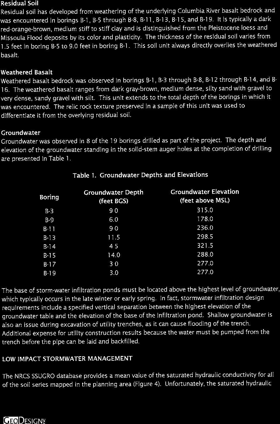
18 TABLES
19 Soil Series Name Soil Map Unit Liquid Limit TABLE 2 Soil Properties and Infiltration Potential West Bull Mountian Planning Area Washington County, Oregon Plasticity Index Percent Sand/ Percent Fines Saturated Infiltration Rate (inches/hour) Depth to Restrictive Layer (feet) Depth to Water Table (feet) Soil Infiltration Potential Aloha silt loam > Medium Cascade silt loam, 3 to 7 percent slopes 7B Low Cascade silt loam, 7 to 12 percent slopes 7C Low Cascade silt loam, 12 to 20 percent slopes 7D Low Chehalis silty clay loam >6.6 >6.6 High Cornelius and Kinton silt loams, 2 to 7 percent slopes 11B Low Cornelius and Kinton silt loams, 7 to 12 percent slopes 11C Low Cornelius and Kinton silt loams, 12 to 20 percent slopes 11D Low Cornelius and Kinton silt loams, 20 to 30 percent slopes 11E Low Cove clay > Low Delena silt loam, 3 to 12 percent slopes 16C Low Helvetia silt loam, 2 to 7 percent slopes 19B > Medium Helvetia silt loam, 7 to 12 percent slopes 19C > Medium Helvetia silt loam, 12 to 20 percent slopes 19D > Low Hillsboro loam, 3 to 7 percent slopes 21B >6.6 >6.6 High Hillsboro loam, 7 to 12 percent slopes 21C >6.6 >6.6 High Hillsboro loam, 12 to 20 percent slopes 21D >6.6 >6.6 Medium Huberly silt loam Low McBee silty clay loam > Medium Quatama loam, 0 to 3 percent slopes 37A > Medium Quatama loam, 3 to 7 percent slopes 37B > Medium Quatama loam, 7 to 12 percent slopes 37C > Medium Wapato silty clay loam > Medium Willamette silt loam, 3 to 7 percent slopes 44B >6.6 >6.6 High Willamette silt loam, 7 to 12 percent slopes 44C >6.6 >6.6 High Woodburn silt loam, 0 to 3 percent slopes 45A > Low Woodburn silt loam, 3 to 7 percent slopes 45B > Low Woodburn silt loam, 12 to 20 percent slopes 45D > Low Xerochrepts and Haploxerolls, very steep 46F >6.6 >6.6 Low Table 2 Otak-31-01:111209
20 ATTACHMENT
21
22
23 SYMBOL SAMPLING DESCRIPTION Location of sample obtained in general accordance with ASTM D 1586 Standard Penetration Test with recovery Location of sample obtained using thin-wall Shelby tube or Geoprobe sampler in general accordance with ASTM D 1587 with recovery Location of sample obtained using Dames & Moore sampler and 300-pound hammer or pushed with recovery Location of sample obtained using Dames & Moore or 3-inch-O.D. split-spoon sampler and 140- pound hammer or pushed with recovery Location of grab sample Graphic Log of Soil and Rock Types Observed contact between soil or rock units (at depth indicated) Rock coring interval Water level during drilling Inferred contact between soil or rock units (at approximate depths indicated) Water level taken on date shown GEOTECHNICAL TESTING EXPLANATIONS ATT Atterberg Limits P Pushed Sample CBR California Bearing Ratio PP Pocket Penetrometer CON DD DS HYD MC MD OC Consolidation Dry Density Direct Shear Hydrometer Gradation Moisture Content Moisture-Density Relationship Organic Content P200 RES SIEV TOR UC VS kpa Percent Passing U.S. Standard No. 200 Sieve Resilient Modulus Sieve Gradation Torvane Unconfined Compressive Strength Vane Shear Kilopascal ENVIRONMENTAL TESTING EXPLANATIONS CA Sample Submitted for Chemical Analysis ND Not Detected P Pushed Sample NS No Visible Sheen PID ppm Photoionization Detector Headspace Analysis Parts per Million SS MS HS Slight Sheen Moderate Sheen Heavy Sheen SW Sequoia Parkway - Suite 100 Portland OR Off Fax EXPLORATION KEY TABLE A-1
24 RELATIVE DENSITY - COARSE-GRAINED SOILS Relative Density Standard Penetration Resistance Dames & Moore Sampler (140-pound hammer) Dames & Moore Sampler (300-pound hammer) Very Loose Loose Medium Dense Dense Very Dense More than 50 More than 120 More than 47 CONSISTENCY - FINE-GRAINED SOILS Consistency Standard Penetration Resistance Dames & Moore Sampler (140-pound hammer) Dames & Moore Sampler (300-pound hammer) Unconfined Compressive Strength (tsf) Very Soft Less than 2 Less than 3 Less than 2 Less than 0.25 Soft Medium Stiff Stiff Very Stiff Hard More than 30 More than 65 More than 31 More than 4.0 COARSE-GRAINED SOILS (more than 50% retained on No. 200 sieve) FINE-GRAINED SOILS (50% or more passing No. 200 sieve) MOISTURE CLASSIFICATION Term dry moist wet PRIMARY SOIL DIVISIONS GROUP SYMBOL GROUP NAME GRAVEL (more than 50% of coarse fraction retained on No. 4 sieve) SAND CLEAN GRAVELS (< 5% fines) GW or GP GRAVEL GRAVEL WITH FINES GW-GM or GP-GM GRAVEL with silt ( 5% and 12% fines) GW-GC or GP-GC GRAVEL with clay GRAVELS WITH FINES (> 12% fines) CLEAN SANDS (<5% fines) GM GC GC-GM SW or SP silty GRAVEL clayey GRAVEL silty, clayey GRAVEL SAND SANDS WITH FINES SW-SM or SP-SM SAND with silt (50% or more of ( 5% and 12% fines) coarse fraction SW-SC or SP-SC SAND with clay passing SM silty SAND SANDS WITH FINES No. 4 sieve) SC clayey SAND (> 12% fines) SC-SM silty, clayey SAND ML SILT CL CLAY Liquid limit less than 50 CL-ML silty CLAY SILT AND CLAY OL ORGANIC SILT or ORGANIC CLAY MH SILT Liquid limit 50 or CH CLAY greater OH ORGANIC SILT or ORGANIC CLAY HIGHLY ORGANIC SOILS PT PEAT Field Test very low moisture, dry to touch ADDITIONAL CONSTITUENTS Percent Fine-Grained Soils Secondary granular components or other materials such as organics, man-made debris, etc. Silt and Clay In: Sand and Gravel In: Coarse- Grained Soils Percent Fine-Grained Soils Coarse- Grained Soils damp, without < 5 trace trace < 5 trace trace visible moisture 5 12 minor with 5 15 minor minor visible free water, > 12 some silty/clayey with with usually saturated > 30 sandy/gravelly sandy/gravelly SW Sequoia Parkway - Suite 100 Portland OR Off Fax SOIL CLASSIFICATION SYSTEM TABLE A-2
25
26
27
28
29
30
31
32
33
34
35
36
37
38
39
40
41
42
43
44
45
 Project: ITHACA-TOMPKINS REGIONAL AIRPORT EXPANSION Project Location: ITHACA, NY Project Number: 218-34 Key to Soil Symbols and Terms TERMS DESCRIBING CONSISTENCY OR CONDITION COARSE-GRAINED SOILS (major
 Photo 1 - Southerly view across 2700 parking lot toward existing building. Multi-residential building borders western side of property in upper right of view. Photo 2 - Southerly view across 2750 parking
Depth (ft) USCS Soil Description TOPSOIL & FOREST DUFF
 USCS Soil Description TOPSOIL & FOREST DUFF") Test Pit No. TP-6 Location: Latitude 47.543003, Longitude -121.980441 Approximate Ground Surface Elevation: 1,132 feet Depth (ft) USCS Soil Description 0 1.5 1.5 5.0 SM 5.0 8.0 SM Loose to medium dense,
Test Pit No. TP-6 Location: Latitude 47.543003, Longitude -121.980441 Approximate Ground Surface Elevation: 1,132 feet Depth (ft) USCS Soil Description 0 1.5 1.5 5.0 SM 5.0 8.0 SM Loose to medium dense,
B-1 BORE LOCATION PLAN. EXHIBIT Drawn By: 115G BROOKS VETERINARY CLINIC CITY BASE LANDING AND GOLIAD ROAD SAN ANTONIO, TEXAS.
 N B-1 SYMBOLS: Exploratory Boring Location Project Mngr: BORE LOCATION PLAN Project No. GK EXHIBIT Drawn By: 115G1063.02 GK Scale: Checked By: 1045 Central Parkway North, Suite 103 San Antonio, Texas 78232
 SOIL CLASSIFICATION CHART COARSE-GRAINED SOILS MORE THAN 50% RETAINED ON NO.200 SIEVE FINE-GRAINED SOILS 50% OR MORE PASSES THE NO.200 SIEVE PRIMARY DIVISIONS GRAVELS MORE THAN 50% OF COARSE FRACTION RETAINED
Solution:Example 1. Example 2. Solution: Example 2. clay. Textural Soil Classification System (USDA) CE353 Soil Mechanics Dr.
 CE353 Soil Mechanics Dr.") CE353 Soil Mechanics CE353 Lecture 5 Geotechnical Engineering Laboratory SOIL CLASSIFICATION Lecture 5 SOIL CLASSIFICATION Dr. Talat A Bader Dr. Talat Bader 2 Requirements of a soil Systems Why do we need
CE353 Soil Mechanics CE353 Lecture 5 Geotechnical Engineering Laboratory SOIL CLASSIFICATION Lecture 5 SOIL CLASSIFICATION Dr. Talat A Bader Dr. Talat Bader 2 Requirements of a soil Systems Why do we need
Field Exploration. March 31, J-U-B ENGINEERS, Inc. 115 Northstar Avenue Twin Falls, Idaho Attn: Mr. Tracy Ahrens, P. E. E:
 March 31, 201 11 Northstar Avenue 83301 Attn: Mr. Tracy Ahrens, P. E. E: taa@jub.com Re: Geotechnical Data Report Preliminary Phase 1 Field Exploration Revision No. 1 Proposed Rapid Infiltration Basin
ADDENDUM 1 FISHER SLOUGH RESTORATION PROJECT SKAGIT COUNTY, WASHINGTON
 F I N A L A D D E N D U M 1 R E P O R T ADDENDUM 1 FISHER SLOUGH RESTORATION PROJECT SKAGIT COUNTY, WASHINGTON REPORT OF GEOTECHNICAL INVESTIGATION URS JOB NO. 3376186 Prepared for Tetra Tech Inc. 142
APPENDIX A. Borehole Logs Explanation of Terms and Symbols
 APPENDIX A Borehole Logs Explanation of Terms and Symbols Page 153 of 168 EXPLANATION OF TERMS AND SYMBOLS The terms and symbols used on the borehole logs to summarize the results of field investigation
BR-01 PAINT BRIDGE NO. 55 C GENERAL PLAN 720'-0" VC 605'-0" VC 1. FOR INDEX TO PLANS, QUANTITIES, AND GENERAL NOTES, SEE "INDEX TO PLANS" SHEET.
 2'-" VC 6'-" VC BB EB 1 1 1 1 1 TV - " TV CONDUITS (COX E 8 - " ELECTRIC CONDUITS (SDG & E T - " TELEPHONE CONDUITS 1. FOR INDEX TO PLANS, QUANTITIES, AND GENERAL NOTES, SEE "INDEX TO PLANS" SHEET. 2.
APPENDIX C. Borehole Data
 APPENDIX C Borehole Data MAJOR DIVISIONS SOIL CLASSIFICATION CHART SYMBOLS GRAPH LETTER TYPICAL DESCRIPTIONS ADDITIONAL MATERIAL
APPENDIX A GEOTECHNICAL REPORT
 The City of Winnipeg Bid Opportunity No. 529-2017 Template Version: C420170317 - RW APPENDIX A GEOTECHNICAL REPORT Quality Engineering Valued Relationships KGS Group 2017 Industrial Street Rehabilitation
CE 240 Soil Mechanics & Foundations Lecture 3.2. Engineering Classification of Soil (AASHTO and USCS) (Das, Ch. 4)
 (Das, Ch. 4)") CE 240 Soil Mechanics & Foundations Lecture 3.2 Engineering Classification of Soil (AASHTO and USCS) (Das, Ch. 4) Outline of this Lecture 1. Particle distribution and Atterberg Limits 2. Soil classification
CE 240 Soil Mechanics & Foundations Lecture 3.2 Engineering Classification of Soil (AASHTO and USCS) (Das, Ch. 4) Outline of this Lecture 1. Particle distribution and Atterberg Limits 2. Soil classification
APPENDIX C HYDROGEOLOGIC INVESTIGATION
 Figure B-5.7 Figure B-5.8 Preliminary Geotechnical and Environmental Report Appendix C Hydrogeologic Investigation APPENDIX C HYDROGEOLOGIC INVESTIGATION December 21, 2011 WESTSIDE SUBWAY EXTENSION PROJECT
Chapter 12 Subsurface Exploration
 Page 12 1 Chapter 12 Subsurface Exploration 1. The process of identifying the layers of deposits that underlie a proposed structure and their physical characteristics is generally referred to as (a) subsurface
Clay Robinson, PhD, CPSS, PG copyright 2009
 Engineering: What's soil got to do with it? Clay Robinson, PhD, CPSS, PG crobinson@wtamu.edu, http://www.wtamu.edu/~crobinson, copyright 2009 Merriam-Webster Online Dictionary soil, noun 1 : firm land
DATA REPORT GEOTECHNICAL INVESTIGATION GALVESTON CRUISE TERMINAL 2 GALVESTON, TEXAS
 DATA REPORT GEOTECHNICAL INVESTIGATION GALVESTON CRUISE TERMINAL 2 GALVESTON, TEXAS SUBMITTED TO PORT OF GALVESTON 123 ROSENBERG AVENUE, 8TH FLOOR GALVESTON, TEXAS 77553 BY HVJ ASSOCIATES, INC. HOUSTON,
Geotechnical Data Report
 Geotechnical Data Report ReWa Solar Farm at Durbin Creek Fountain Inn, South Carolina September 1, 2017 Terracon Project No. 86165043 Prepared for: Renewable Water Resources Greenville, South Carolina
Civil Engineering, Surveying and Environmental Consulting WASP0059.ltr.JLS.Mich Ave Bridge Geotech.docx
 2365 Haggerty Road South * Canton, Michigan 48188 P: 734-397-3100 * F: 734-397-3131 * www.manniksmithgroup.com August 29, 2012 Mr. Richard Kent Washtenaw County Parks and Recreation Commission 2330 Platt
Dashed line indicates the approximate upper limit boundary for natural soils. C L o r O L C H o r O H
 SYMBOL SOURCE 8 9 1 SOIL DATA NATURAL SAMPLE DEPTH WATER PLASTIC LIQUID PLASTICITY NO. CONTENT LIMIT LIMIT INDEX (%) (%) (%) (%) Client: County of Berthoud Project: Project No.: Boring B-2 S-1-5' 6.2 8
Parsons APPENDIX A BORING LOGS AND DEVELOPMENT LOG
 Parsons APPENDIX A BORING LOGS AND DEVELOPMENT LOG GEOLOGIC LOG DATE STARTED: DATE COMPLETED: 08-Sep-09 08-Sep-09 LOGGER: Quin Kinnebrew WEATHER: Clear & Warm PAGE 1 OF 2 WELL NO. GMW-66 COMPANY NAME:
GZA GeoEnvironmental, Inc.
 GZA BORING NO.: GZ-1 SHEET: 1 of 1 PROJECT NO: 9.223. Drilling Co.: Geologic Type of Rig: Skid Boring Location: See Plan H. Datum: See Plan Rig Model: Mudline : Foreman: Ray Eastwood CME -.8 Final Boring
CITY OF VALDEZ Project Title: East Pioneer Reconstruction Project No.: Contract No.: TO: All Recipients Date: April 14, 2014
 CITY OF VALDEZ Project Title: East Pioneer Reconstruction Project No.: 13-3-1.32 Contract No.: 11 TO: All Recipients Date: April 14, 214 SUBJECT: Addendum No.1 This seventeen (17) page Addendum forms a
Boreholes. Implementation. Boring. Boreholes may be excavated by one of these methods: 1. Auger Boring 2. Wash Boring 3.
 Implementation Boreholes 1. Auger Boring 2. Wash Boring 3. Rotary Drilling Boring Boreholes may be excavated by one of these methods: 4. Percussion Drilling The right choice of method depends on: Ground
December 5, Junction Gateway, LLC 7551 W. Sunset Boulevard #203 Los Angeles, CA Mr. James Frost P: Dear Mr.
 December 5, 2014 Junction Gateway, LLC 7551 W. Sunset Boulevard #203 90046 Attn: Re: Mr. James Frost P: 323.883.1800 Geotechnical Update Letter Sunset & Effie Mixed Use Development 4301 to 4311 Sunset
Soil Mechanics Brief Review. Presented by: Gary L. Seider, P.E.
 Soil Mechanics Brief Review Presented by: Gary L. Seider, P.E. 1 BASIC ROCK TYPES Igneous Rock (e.g. granite, basalt) Rock formed in place by cooling from magma Generally very stiff/strong and often abrasive
Appendix J. Geological Investigation
 Appendix J Geological Investigation Appendix J Geological Environment Table of Contents Page 1 INTRODUCTION...J-1 1.1 Purpose of the Investigation...J-1 1.2 Scope of the Investigation...J-1 2 METHODO OF
 TP-1 N61E 0 DARK BROWN SANDY SILT (ML) stiff, wet with roots (Disturbed Surficial Soil) DEPTH (FEET) 5 REDDISH BROWN SANDSTONE intensely fractured, weak to friable, deeply weathered, tight (Franciscan
Report of Preliminary Geotechnical Exploration. CSO-012 Sewer Separation Cincinnati, Hamilton County, Ohio. February, 2011
 11242843_GeoTech_Preliminary - Feburary 2011_1/40 Report of Preliminary Geotechnical Exploration CSO-012 Sewer Separation Cincinnati, Hamilton County, Ohio February, 2011 11242843_GeoTech_Preliminary -
Preliminary Geotechnical Investigation Cadiz / Trigg County I-24 Business Park. Cadiz, Kentucky
 Environmental & Geoscience, LLC 834 Madisonville Road Hopkinsville, KY 440 70.44.000 FAX 70.44.8300 www.wedrill.com A member of Trinity Energy & Infrastructure Group, LLC Preliminary Geotechnical Investigation
New WW Hastings Hospital Geotechnical Investigation RFP Addendum #1
 88 E. Marshall Street, Suite 0 Tulsa, OK 76 98 8 9 Phone 98 8 798 FAX DATE: April 9, 0 ADDENDUM NO.: PROJECT: New WW Hastings Hospital BID PACKAGE NO: Geotechnical Investigation RFP SUBMITTED BY: CNCR
Correlation of unified and AASHTO soil classification systems for soils classification
 Journal of Earth Sciences and Geotechnical Engineering, vol. 8, no. 1, 2018, 39-50 ISSN: 1792-9040 (print version), 1792-9660 (online) Scienpress Ltd, 2018 Correlation of unified and AASHTO classification
Northern Colorado Geotech
 PRELIMINARY GEOTECHNICAL ENGINEERING REPORT PROPOSED CECIL FARMS DEVELOPMENT WELD COUNTY ROAD 7, BETWEEN ROADS 7 AND 7 SEVERANCE, COLORADO NORTHERN COLORADO GEOTECH PROJECT NO. 0-6 APRIL 0, 06 Prepared
Introduction to Soil Mechanics Geotechnical Engineering-II
 Introduction to Soil Mechanics Geotechnical Engineering-II ground SIVA Dr. Attaullah Shah 1 Soil Formation Soil derives from Latin word Solum having same meanings as our modern world. From Geologist point
Technical Memorandum. Soil Borings
 Technical Memorandum To: Project File and Appendix F to Sediment Remedial Investigation Report From: Sara L. Leow, PE Subject: Geotechnical Investigation and Results Summary Date: February 213 Project:
Geotechnical Engineering Report
 Geotechnical Engineering Report Turner Turnpike Widening Bridge B Bridge Crossing: South 257 th West Avenue Creek County, Oklahoma June 1, 2016 Terracon Project No. 04155197 Prepared for: Garver, LLC Tulsa,
B-1 SURFACE ELEVATION
 5A 5B LOGGED BY El. S. Bhangoo DRILLING CONTRACTOR Pitcher Drilling DRILLING METHOD Rotary Wash BEGIN DATE 12-14-12 SAMPLER TYPE(S) AND SIZE(S) (ID) SPT, MC BOREHOLE BACKFILL AND COMPLETION COMPLETION
Geotechnical Engineering Report
 Geotechnical Engineering Report Single-Span Bridge North Western Road & Hall of Fame Avenue August 25, 2015 Terracon Project No. 03155156 Prepared for: Olsson Associates Prepared by: Terracon Consultants,
SOIL FORMATION SOIL CLASSIFICATION FOR GEOTECHNICAL ENGINEERS. Soil Properties and Classification
 SOIL CLASSIFICATION FOR GEOTECHNICAL ENGINEERS Soil Properties and Classification Soil Formation Soil Types Particle Size Analysis and Grading Characteristics Consistency Indices Engineering classification
Dry Muliwai Sample Location Map
 DMM2 DMM1 P:\AthruR\K838-Makua\GIS\Layouts\Dry Muliwai.mxd.mxd - 3/26/3 - JC DMM3 5 Dry Muliwai Sample Location Map Figure 2-4 P:\AthruR\K838-Makua\GIS\Layouts\orth Background Muliwai.mxd.mxd - 3/26/3
Geotechnical Data Report
 Geotechnical Data Report Downtown Greenville Future Conveyance Study December 1, 2015 Terracon Project No. 86155032 Prepared for: Prepared by: Terracon Consultants, Inc. December 1, 2015 561 Mauldin Road
UAS Student Residence
 General Notes, Abbreviations and Symbols C100 MATCH LINE - SEE SHEET L6 Existing Site Topographic Conditions C101 MATCH LINE - SEE SHEET L5 Existing Site Topographic Conditions C102 DEPTH(FT.) 5 FROZEN
Appendix A. Producer Statement Advisory Note
 Appendix A Producer Statement Advisory Note Ref. No. 17095 26 May 2017 PRODUCER STATEMENT CONSTRUCTION REVIEW (PS4) IMPORTANT ADVISORY NOTE The Building Consent Authority (BCA) frequently requires Producer
PRELIMINARY GEOTECHNICAL REPORT. State College Redevelopment State College Borough, Centre County, Pennsylvania. CMT Laboratories File No.
 PRELIMINARY GEOTECHNICAL REPORT State College Redevelopment State College Borough, Centre County, Pennsylvania CMT Laboratories File No. 1638700 Prepared for: National Development Council One Battery Park
patersongroup Design for Earthquakes Consulting Engineers May 19, 2016 File: PG3733-LET.01
 patersongroup May 19, 2016 File: PG3733-LET.01 Hydro Ottawa Limited c/o Cresa Toronto 170 University Avenue, Suite 1 Toronto, Ontario M5H 3B3 Attention: Ms. Barbara Wright Consulting Engineers 154 Colonnade
DRILL HOLE # BH-BGC13-FN-01
 DILL HOLE # BH-BGC3-FN-0 Drill Method: Mud otary/coring Depth To ock (m): N/A Page of 7 eviewed by: AJB 0 GAVEL (GW) Fine to coarse, sandy, well graded, dense, max particle size = 30 mm, angular to subrounded,
GEOTECHNICAL REPORT. Matanuska-Susitna Borough. Parks Highway Connections Museum Drive. Matanuska-Susitna Borough, Alaska.
 Matanuska-Susitna Borough GEOTECHNICAL REPORT Parks Highway Connections Museum Drive Matanuska-Susitna Borough, Alaska March 2, 20 Prepared By: John Thornley, PE Geotechnical Engineer 333 Arctic Blvd.,
IN SITU SPECIFIC GRAVITY VS GRAIN SIZE: A BETTER METHOD TO ESTIMATE NEW WORK DREDGING PRODUCTION
 IN SITU SPECIFIC GRAVITY VS GRAIN SIZE: A BETTER METHOD TO ESTIMATE NEW WORK DREDGING PRODUCTION Nancy Case O Bourke, PE 1, Gregory L. Hartman, PE 2 and Paul Fuglevand, PE 3 ABSTRACT In-situ specific gravity
AN EMPLOYEE OWNED COMPANY
 CTL Engineering, Inc. 2860 Fisher Road, P.O. Box 4448, Columbus, Ohio 43204338 Phone: 614/2768123 Fax: 614/2766377 Email: ctl@ctleng.com AN EMPLOYEE OWNED COMPANY Consulting Engineers Testing Inspection
December 13, Washington County Public Works Department Myeron Road North Stillwater, MN Attn: Mr. Andrew Giesen
 CONSULTANTS ENVIRONMENTAL GEOTECHNICAL MATERIALS FORENSICS December 13, 2016 Washington County Public Works Department 11660 Myeron Road North Stillwater, MN 55082 Attn: Mr. Andrew Giesen RE: Geotechnical
ENGINEERING ASSOCIATES
 July 16, 211 Vista Design, Inc. 11634 Worcester Highway Showell, Maryland 21862 Attention: Reference: Dear Mr. Polk: Mr. Richard F. Polk, P.E. Geotechnical Engineering Report Charles County RFP No. 11-9
APPENDIX B: BORING LOGS
 New Orleans Levee Systems Independent Levee Hurricane Katrina Investigation Team July, 6 APPENDIX B: BORING S As part of the field investigation 9 borings were performed at the sites of interest, as listed
3.0 SUMMARY OF FINDINGS
 AECOM 500 W Jefferson St. Suite 1600 Louisville, KY 40202 www.aecom.com 502-569-2301 tel 502-569-2304 fax October 17, 2018 Big Rivers Electric Corporation Sebree Generating Station 9000 Highway 2096 Robards,
 R-1 Conveyor Relocation Project Legend 0 500 1000 1500 ft. This map is a user generated static output from an Internet mapping site and is for general reference only. Data layers that appear on this map
Limited Geotechnical Engineering Evaluation Classroom Additions Albany County Campus Laramie, Wyoming
 Limited Geotechnical Engineering Evaluation Classroom Additions Albany County Campus 2300 Missile Drive, Cheyenne, Wyoming 82001 Phone 307-635-0222 www.stratageotech.com Limited Geotechnical Engineering
APPENDIX F CORRELATION EQUATIONS. F 1 In-Situ Tests
 APPENDIX F 1 APPENDIX F CORRELATION EQUATIONS F 1 In-Situ Tests 1. SPT (1) Sand (Hatanaka and Uchida, 1996), = effective vertical stress = effective friction angle = atmosphere pressure (Shmertmann, 1975)
Geotechnical Properties of Soil
 Geotechnical Properties of Soil 1 Soil Texture Particle size, shape and size distribution Coarse-textured (Gravel, Sand) Fine-textured (Silt, Clay) Visibility by the naked eye (0.05 mm is the approximate
4. Soil Consistency (Plasticity) (Das, chapter 4)
 (Das, chapter 4)") 4. Soil Consistency (Plasticity) (Das, chapter 4) 1 What is Consistency? Consistency is a term used to describe the degree of firmness of fine-grained soils (silt and clay). The consistency of fine grained
4. Soil Consistency (Plasticity) (Das, chapter 4) 1 What is Consistency? Consistency is a term used to describe the degree of firmness of fine-grained soils (silt and clay). The consistency of fine grained
PLATE 6 FEB G r o v e l a n d F l o o d w a l l - B o r e h o l e M a p. Legend. Groveland Floodwall Boreholes. Contour Lines.
 611 6 Defau FALS conto Conto DPLV lt Eurs20 01_to 3po Defau FALS conto Conto DPLV lt Eurs20 01_to 4po 612 Conto DPLV conto Defau FALS 01_to urs20 Elt po 5 Conto DPLV conto Defau FALS 01_to urs15 Elt po
Geotechnical Engineering Report
 Geotechnical Engineering Report Turner Turnpike Widening Polecat Creek Bridge (Bridge A) June 1, 2016 Terracon Project No. 04155197 Prepared for: Garver, LLC Prepared by: Terracon Consultants, Inc. TABLE
SHEAR STRENGTH OF SOIL
 Soil Failure Criteria SHEAR STRENGTH OF SOIL Knowledge about the shear strength of soil important for the analysis of: Bearing capacity of foundations, Slope stability, Lateral pressure on retaining structures,
Geotechnical Data Report
 Geotechnical Data Report Emergency Bridge Package 6 Richland County, South Carolina May 12, 2016 SCDOT Project ID.: P029942, P029943, P029944 Terracon Project No. 73100L (Rev. 1) Prepared for: South Carolina
Appendix G GEOLOGICAL INVESTIGATION
 Appendix G GEOLOGICAL INVESTIGATION JOB NUMBER: 3268.001 DATE: 10-14-13 BY: CC SITE 0 2000 1"=2000' VICINITY MAP CARGILL PARCEL HICKORY STREET AND ENTERPRISE DRIVE NEWARK, CALIFORNIA FOR
Geotechnical Engineering Study, Conifer Senior High School Football Field Improvements, Conifer, Colorado
 2390 South Lipan Street Denver, CO 80223 phone: (303) 742-9700 fax: (303) 742-9666 email: kadenver@kumarusa.com www.kumarusa.com Office Locations: Denver (HQ), Colorado Springs, Fort Collins, and Frisco,
Chapter 1 - Soil Mechanics Review Part A
 Chapter 1 - Soil Mechanics Review Part A 1.1 Introduction Geotechnical Engineer is concerned with predicting / controlling Failure/Stability Deformations Influence of water (Seepage etc.) Soil behavour
 UNIT DESCRIPTIONS: Artificial Fill, Undocumented (Afu): Locally derived sandy silt and silty sand, locally with clay and varying amounts of gravel and man-made debris. Abundant concrete rubble, in places
NAPLES MUNICIPAL AIRPORT
 NAPLES MUNICIPAL AIRPORT NAPLES MUNICIPAL AIRPORT (APF) TAXIWAY D REALIGNMENT AND DRAINAGE IMPROVEMENTS NORTH QUADRANT ADDENDUM NUMBER TWO March, The following Addendum is hereby made a part of the Plans
Tikrit University College of Engineering Civil engineering Department
 Tikrit University SOIL CLASSIFICATION College of Engineering Civil engineering Department Soil Mechanics 3 rd Class Lecture notes Up Copyrights 2016 Classification of soil is the separation of soil into
GEOTECHNICAL INVESTIGATION REPORT
 GEOTECHNICAL INVESTIGATION REPORT SOIL INVESTIGATION REPORT FOR STATIC TEST FACILITY FOR PROPELLANTS AT BDL, IBRAHIMPATNAM. Graphics Designers, M/s Architecture & Engineering 859, Banjara Avenue, Consultancy
The attitude he maintains in his relation to the engineer is very well stated in his own words:
 Su bsurface Soil Exploration, 53: 139 Foundation Engineering Geotechnical companies that have a history of experience in a given region usually have extensive boring logs and maps telling where the borings
Sci.Int (Lahore), 25(4), , 2013 ISSN ; CODEN: SINTE 8 531
, 25(4), , 2013 ISSN ; CODEN: SINTE 8 531") Sci.Int (Lahore), 25(4),531-537, 2013 ISSN 1013-5316; CODEN: SINTE 8 531 PROFILING AND ZONING OF GEOTECHNICAL SUB-SOIL DATA USING GEOGRAPHIC INFORMATION SYSTEM Mahmood Ahmad*, Qaiser Iqbal and Fayaz Ahmad
Sci.Int (Lahore), 25(4),531-537, 2013 ISSN 1013-5316; CODEN: SINTE 8 531 PROFILING AND ZONING OF GEOTECHNICAL SUB-SOIL DATA USING GEOGRAPHIC INFORMATION SYSTEM Mahmood Ahmad*, Qaiser Iqbal and Fayaz Ahmad
GEOLOGIC/GEOTECHNICAL INVESTIGATION FOR TENTATIVE MAP LAVENIDA SUBDIVISION (APN # ) ORINDA, CALIFORNIA
 ORINDA, CALIFORNIA") GEOLOGIC/GEOTECHNICAL INVESTIGATION FOR TENTATIVE MAP LAVENIDA SUBDIVISION (APN #271-120-011) ORINDA, CALIFORNIA A 580 Ts 590 HMA-1 600 HMA-2 70 Ts 610 Ts HMA-3 HLA-5 GJA-6 LD-2 23
GEOLOGIC/GEOTECHNICAL INVESTIGATION FOR TENTATIVE MAP LAVENIDA SUBDIVISION (APN #271-120-011) ORINDA, CALIFORNIA A 580 Ts 590 HMA-1 600 HMA-2 70 Ts 610 Ts HMA-3 HLA-5 GJA-6 LD-2 23
Pierce County Department of Planning and Land Services Development Engineering Section
 Page 1 of 7 Pierce County Department of Planning and Land Services Development Engineering Section PROJECT NAME: DATE: APPLICATION NO.: PCDE NO.: LANDSLIDE HAZARD AREA (LHA) GEOLOGICAL ASSESSMENT REPORT
Report of Geotechnical Data
 Report of Geotechnical Da NAMA Rehabilite Potable Wer Lines Washington, DC F&R Project No. 7U89 Prepared For: CHM Hill 87 Stony Point Parkway, Suite 11 Richmond, Virginia 335 Prepared By: Froehling & Robertson,
February 16, 2015 File No Ms. Robin Yates TRC Engineers Inc N. Fresno Street, Suite 200 Fresno, California 93710
 February 16, 2015 File No. 20152738 Ms. Robin Yates TRC Engineers Inc. 6051 N. Fresno Street, Suite 200 Fresno, California 93710 SUBJECT: Geotechnical Design Memorandum Fresno BPMP Scour Countermeasure
Attachment B. Grain Size Distribution Curves
 Attachment B Grain Size Distribution Curves AREVA Resources Canada Inc. Kiggavik Project EIS December 11 Attachment B Technical Appendix 6A Surficial Geology and Terrain Client: Areva Project:
Appendix E. Phase 2A Geotechnical Data
 Appendix E Phase 2A Geotechnical Data Appendix E1 Geotechnical Testing of Sediment ApPENDIX El. GEOTECHNICAL TESTING OF SEDIMENT (Modified from Exponent, 20Q1c) E.I Introduction This appendix presents
Assessment of accuracy in determining Atterberg limits for four Iraqi local soil laboratories
 IOP Conference Series: Materials Science and Engineering PAPER OPEN ACCESS Assessment of accuracy in determining Atterberg limits for four Iraqi local soil laboratories To cite this article: H O Abbas
Geotechnical Data Report
 Geotechnical Data Report S-38-50 (Four Holes Road) over I-26 Emergency Bridge Replacement Orangeburg County, South Carolina May 22, 2018 (Revision 1) SCDOT Project ID.: P037465 Terracon Project No. 73155050U
Appendix F Laboratory test results
 Appendix F Laboratory test results SOIL AND ROCK SAMPLE ANALYSIS LABORATORY TEST REPORT To: Bord Gais Copy: Orla Smyth (kkidd@bge.ie) From: Stephen Watson Laboratory Manager Causeway Geotech Ltd Tel: +44(0)2827666640
Geotechnical Engineering Report
 Geotechnical Engineering Report SH-9 Bridge over Wewoka Creek Hughes County, Oklahoma Job Piece No. 27059(04) July 16, 2015 Terracon Project No. 04125055 Prepared for: Holloway, Updike, and Bellen, Inc.
CITY OF CAPE CORAL NORTH 2 UTILITIES EXTENSION PROJECT CONTRACT 3
 GEOTECHNICAL REPORT CITY OF CAPE CORAL NORTH UTILITIES EXTENSION PROJECT CONTRACT City of Cape Coral Procurement Division Cultural Park Boulevard, nd Floor Cape Coral, FL ISSUED FOR BID VOLUME of GEOTECHNICAL
DATE: 5/17/2012. LOGGED BY: Geoff Richards. COMPANY: Tetra Tech EM, Inc. DRILL FOREMAN: Walter
 ATTACHMENT 2 Page 1 of 1 B1 0 1 2 FILL, Dry; brownish red; clayey silt and gravel; ~30% gravel size fragments of dark grey microcrystalline (aphanetic), extrusive, igneous, rock 3 B1-4a 1100 B1-4b-duplicate
SOIL CHARACTERIZATION OF JABALPUR CITY USING BORE LOGS
 ISSN 77-685 IJESR/June 16/ Vol-6/Issue-6/131-135 Mrinal Singh et. al., / International Journal of Engineering & Science Research SOIL CHARACTERIZATION OF JABALPUR TY USING BORE LOGS ABSTRACT Mrinal Singh*
GEOTECHNICAL ENGINEERING SERVICES REPORT
 GEOTECHNICAL ENGINEERING SERVICES REPORT BRIDGE OVER BIG CREEK APPROXIMATELY.8 MILES EAST OF THE INTERSECTION OF COUNTY ROAD EW1546 AND COUNTY ROAD 193 LEFLORE COUNTY, OKLAHOMA PROJECT No. J2-8616(5),
VOLUME III GEOLOGY, HYDROGEOLOGY & GEOTECHNICAL REPORT CAPITAL REGION RESOURCE RECOVERY CENTRE
 VOLUME III GEOLOGY, HYDROGEOLOGY & GEOTECHNICAL REPT CAPITAL REGION RESOURCE RECOVERY CENTRE APPENDIX A Borehole Records December Report No. //vol III LIST OF ABBREVIATIONS The abbreviations coonly employed
Geotechnical Investigation
 Geotechnical Investigation Slope Stability Analysis for the Existing Slope Southwest of the Proposed Condo Developments 50 Ann Street, Bolton, Ontario Prepared For: Brookfield Homes (Ontario) Limited GeoPro
Module 1 GEOTECHNICAL PROPERTIES OF SOIL AND OF REINFORCED SOIL (Lectures 1 to 4)
") Module 1 GEOTECHNICAL PROPERTIES OF SOIL AND OF REINFORCED SOIL (Lectures 1 to 4) Topics 1.1 INTRODUCTION 1.2 GRAIN-SIZE DISTRIBUTION Sieve Analysis Hydrometer Analysis 1.3 SIZE LIMITS FOR SOILS 1.4 WEIGHT-VOLUME
Module 1 GEOTECHNICAL PROPERTIES OF SOIL AND OF REINFORCED SOIL (Lectures 1 to 4) Topics 1.1 INTRODUCTION 1.2 GRAIN-SIZE DISTRIBUTION Sieve Analysis Hydrometer Analysis 1.3 SIZE LIMITS FOR SOILS 1.4 WEIGHT-VOLUME
Geotechnical Recommendations for Proposed Additions to the Three Mile Creek Severe Weather Attenuation Tank Project
 TECHNICAL MEMORANDUM Geotechnical Recommendations for Proposed Additions to the Three Mile Creek Severe Weather Attenuation Tank Project PREPARED FOR: PREPARED BY: DATE: June 28, 218 PROJECT NUMBER: 697482
APÉNDICE F. Evaluación Geotécnica
 APÉNDICE F Evaluación Geotécnica REPORT ON GEOTECHNICAL INVESTIGATION FOR PROPOSED LAGUNA DEL MAR PLAZA PROJECT ASHFORD AVE. SAN JUAN, PUERTO RICO GUTIERREZ - LATIMER - C.S.P. MR. ROBERTO CACHO I LAGUNA
Shear Strength of Soils
 Shear Strength of Soils STRESSES IN A SOIL ELEMENT t s v Analyze Effective Stresses (s ) Load carried by Soil t Where: s H t t s H s = t f = s v = s H = t = s v Stresses in a Soil Element after Figure
The process of determining the layers of natural soil deposits that will underlie a proposed structure and their physical properties is generally
 The process of determining the layers of natural soil deposits that will underlie a proposed structure and their physical properties is generally referred to as sub surface investigation 2 1 For proper
GEOTECHNICAL SITE CHARACTERIZATION
 GEOTECHNICAL SITE CHARACTERIZATION Neil Anderson, Ph.D. Professor of Geology and Geophysics Richard W. Stephenson, P.E., Ph.D. Professor of Civil, Architectural and Environmental Engineering University
PRELIMINARY GEOTECHNICAL ENGINEERING REPORT. Proposed Re-Development 44 Old Worcester Road Charlton, Massachusetts. Prepared For:
 PRELIMINARY GEOTECHNICAL ENGINEERING REPORT Proposed Re-Development 44 Old Worcester Road Charlton, Massachusetts Prepared For: Meridian Associates, Inc. 500 Cummings Center, Suite 5950 Beverly, Massachusetts
Geotechnical Subsurface Exploration and Laboratory Testing Data Report
 Geotechnical Subsurface Exploration and Laboratory Testing Data Report 2016 1A Emergency Bridge Replacement Package SCDOT PIN P031819 S 19 (Highway 19 East) Bridge over Bug Swamp Horry County, South Carolina
Soils. Technical English - I 10 th week
 Technical English - I 10 th week Soils Soil Mechanics is defined as the branch of engineering science which enables an engineer to know theoretically or experimentally the behavior of soil under the action
REPORT OF PRELIMINARY SUBSURFACE EXPLORATION. VCU Basketball Practice Facility 1300/1328 West Marshall Street City of Richmond, Virginia.
 REPORT OF PRELIMINARY SUBSURFACE EXPLORATION VCU Basketball Practice Facility 100/18 West Marshall Street City of Richmond, Virginia For Mr. Carl F. Purdin, AIA Assistant Director of Design Services VCU
Geotechnical Investigation Juneau Seawalk - Taku Fisheries to Miner s Wharf Juneau, Alaska DM&A Job No
 Duane Miller & Associates 5821 Arctic Boulevard, Suite A Anchorage, AK 99518-1654 (907) 644-3200 Fax 644-0507 Arctic & Geotechnical Engineering May 4, 2006 Tetra Tech/KCM, Inc. 1971 First Avenue Seattle,
Manual on Subsurface Investigations National Highway Institute Publication No. FHWA NHI Federal Highway Administration Washington, DC
 Manual on Subsurface Investigations National Highway Institute Publication No. FHWA NHI-01-031 Federal Highway Administration Washington, DC Geotechnical Site Characterization July 2001 by Paul W. Mayne,
CIVE.5370 EXPERIMENTAL SOIL MECHANICS Soil Sampling, Testing, & Classification Review
 DATA COLLECTION, INTERPRETATION, & ANALYSIS TO GEOTECHNICAL SOLUTIONS FLOW CHART PRIOR INFORMATION Reconnaissance Topography Geology Hydrology Environment SITE EXPLORATION Geophysics Drilling and Coring