|
|
|
- Felix Pope
- 5 years ago
- Views:
Transcription
1
2
3
4
5
6
7
8

9
10
11
12
13
14
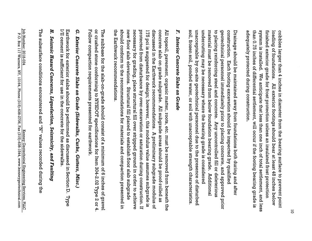
15 Project: ITHACA-TOMPKINS REGIONAL AIRPORT EXPANSION Project Location: ITHACA, NY Project Number: Key to Soil Symbols and Terms TERMS DESCRIBING CONSISTENCY OR CONDITION COARSE-GRAINED SOILS (major portions retained on No. 2 sieve): includes (1) clean gravel and sands and (2) silty or clayey gravels and sands. Condition is rated according to relative density as determined by laboratory tests or standard penetration resistance tests. Descriptive Terms Relative Density Blow Count Major Divisions Very loose Loose Medium dense Dense Very dense Typical Names < 4 4 to to 3 3 to > FINE-GRAINED SOILS (major portions passing on No. 2 sieve): includes (1) inorganic and organic silts and clays, (2) gravelly, sandy, or silty clays, and (3) clayey silts. Consistency is rated according to shearing strength, as indicated by penetrometer readings, blow count, or unconfined compression tests. Unconfined Compressive Descriptive Terms Strength kpa Blow Count Very soft Soft Medium stiff Stiff Very stiff Hard Group Symbols to 1 % 1 to 3 % 3 to 6 % 6 to 8 % 8 to % < 2 2 to to to 2 2 to > < 2 2 to 4 4 to 8 8 to 1 1 to 3 > 3 GENERAL NOTES 1. Classifications are based on the United Soil Classification System and include consistency, moisture, and color. Field descriptions have been modified to reflect results of laboratory tests where deemed appropriate. 2. Surface elevations are based on topographic maps and estimated locations. 3. Descriptions on these boring logs apply only at the specific boring locations and at the time the borings were made. They are not guaranteed to be representative of subsurface conditions at other locations or times. Laboratory Classification Criteria Coarse-Grained soils (More than half the material is larger than No. 2 sieve size) Gravels (More than half of coarse fraction is larger than No. 4 sieve size) Sands (More than half of coarse fraction is smaller than No. 4 sieve size) Clean gravel (Little or no fines) Gravel with fines (Appreciable amount of fines) Clean sands (Little or no fines) Sands with fines (Appreciable amount of fines) GW GP d GM* u GC SW SP d SM* u SC Well-graded gravels, gravel-sand mixtures, little or no fines Poorly-graded gravels, gravel-sand mixtures, little or no fines Silty gravels, gravel-sand-silt mixtures Clayey gravels, gravel-sand-silt mixtures Well-graded sands, gravelly sands, little or no fines Poorly-graded sands, gravelly sands, little or no fines Silty sands, sand-silt mixtures Clayey sands, sand-clay mixtures Determine percentages of sand and gravel from grain size curve, Depending on percentage of fines (fraction smaller than No. 2 sieve) coarse-grained soils are classified as follows: Less than percent... GW, GP, SW, SP More than 12 percent... GM, GC, SM, SC 6 to 12 percent... Borderline case4s requiring dual symbols** C = U D 6 D greater than 4; Not meeting all gradation requirements for GW Atterberg limits below "A" line or P.I. less than 4 Atterberg limits above "A" line or P.I. greater than 7 Not meeting all gradation requirements for SW Atterberg limits below "A" line or P.I. less than 4 Atterberg limits above "A" line or P.I. greater than 7 C C = ( D 3 ) 2 D x D 6 between 1 and 3 Above "A" line with P.I. between 4 and 7 are borderline cases requiring use of dual symbols D ( D = greater than 6; 3 ) 2 6 C C = between 1 and 3 U D C D x D 6 Above "A" line with P.I. between 4 and 7 are borderline cases requiring use of dual symbols Particle Size Sieve sizes mm Material < #2 <.74 Silt or clay Sand #2 to #.74 to.42 Fine # to #.42 to 2. Medium # to #4 2. to 4.76 Coarse Fine-Grained soils (More than half the material is smaller than No. 2 sieve size) * ** Silts and Clays (Liquid limit less than 6) Silts and Clays (Liquid limit greater than 6) Highly Organic Soils ML CL OL MH CH OH Pt Inorganic silts and very fine sands, rock floor, silty or clayey fine sands or clayey silts with slight plasticity Inorganic clays of low to medium plasticity, gravelly clays, sandy clays, silty clays, lean clays Organic silts and organic silty clays of low plasticity Inorganic silts, micaceous or distomaceous fine sandy or silty soils, organic silts Inorganic clays of high plasticity, fat clays Organic clays of medium to high plasticity, organic silts Peat and other highly organic soils MH OR OH 7 CL-ML 4 ML OR OL LIQUID LIMIT (LL) Division of GM and SM groups into subdivisions of d and u are for roads and airfields only. Subdivision is based on Atterberg Limits: suffix d used when L.L. is 23 or less and the P.I. is 6 or less; the suffix is used when L.L. is greater than 26. Borderline classifications used for soils possessing characteristics of two groups are designated by combinations of groups symbols. For example; GW-GC, well-graded gravel-sand mixture with clay binder. PLASTICITY INDEX (PI) FOR CLARIFICATION OF FINE-GRAINED SOIL AND FINE-GRAINED FRACTION OF COARSE-GRAINED SOILS OR CL OL Plasticity Chart OR CH OH "U" LINE "A" LINE Particle Size Material mm Sieve Gravel Fine 4.76 to 19.1 #4 to 3/4 in. 3/4 in. to 3 in. 3 in. to 12 in. 12 in. to 36 in. Coarse 19.1 to to to Cobble Boulders
16 Kenney Geotechnical Engineering Services, PLLC 691 Herman Road LITHOLOGIC SYMBOLS (Unified Soil Classification System) ASPHALT: Asphalt CL-ML: USCS Low Plasticity Silty Clay SAMPLER SYMBOLS Rock Core Standard Penetration Test KEY TO SYMBOLS CLS: USCS Low Plasticity Sandy Clay GM: USCS Silty Gravel GWS: USCS Well-graded Sandy Gravel KEY TO SYMBOLS - GINT STD US LAB.GDT - 4/19/18 17:33 - C:\PROGRAM FILES (X86)\GINT\PROJECTS\ ITHACA-TOMPKINS REGIONAL AIRPORT.GPJ LL PI W DD NP -2 PP MLS: USCS Sandy Silt SC: USCS Clayey Sand SHALE: Shale SM: USCS Silty Sand SWG: USCS Well-graded Gravelly Sand TOPSOIL: Topsoil -LIQUID LIMIT (%) -PLASTIC INDEX (%) - MOISTURE CONTENT (%) - DRY DENSITY (PCF) - NON PLASTIC - PERCENT PASSING NO. 2 SIEVE - POCKET PENETROMETER (TSF) ABBREVIATIONS WELL CONSTRUCTION SYMBOLS TV -TORVANE PID - PHOTOIONIZATION DETECTOR UC - UNCONFINED COMPRESSION ppm - PARTS PER MILLION Water Level at Time Drilling, or as Shown Water Level at End of Drilling, or as Shown Water Level After 24 Hours, or as Shown
17 LOGGED BY RS NOTES Kenney Geotechnical Engineering Services, PLLC 691 Herman Road DATE STARTED 7/2/18 COMPLETED 7/2/18 DRILLING CONTRACTOR Kenney Geotechnical Services DRILLING METHOD 3.2" HSA CHECKED BY CMK GROUND ELEVATION GROUND WATER LEVELS: AT TIME OF DRILLING --- AT END OF DRILLING --- HOLE SIZE 8" AFTER DRILLING 7. ft ; CAVE AT 9.9 ft BORING NUMBER AB-1 PAGE 1 OF 1 DEPTH (ft) GRAPHIC LOG MATERIAL DESCRIPTION ASPHALT (GW) GRAY BROWN MEDIUM DENSE SANDY GRAVEL, MOIST ROOTS PRESENT AT 2'-4' SAMPLE TYPE NUMBER 1 RECOVERY % (RQD) BLOW COUNTS (N VALUE) (13) POCKET PEN. (tsf) VOC (ppm) N VALUE PL MC LL FINES CONTENT (%) GEOTECH BH PLOTS - GINT STD US LAB.GDT - 7/12/18 8:3 - C:\PROGRAM FILES (X86)\GINT\PROJECTS\ ITHACA-TOMPKINS REGIONAL AIRPORT.GPJ (CL) GRAY BROWN STIFF SANDY CLAY WITH GRAVEL, MOIST SHALE FRAGMENTS ENCOUNTERED AT 8'-13' OLIVE-GRAY-BLUE HIGHLY WEATHERED SHALE AUGER REFUSAL AT 13.1' Refusal at 13.6 feet. Bottom of borehole at 13.6 feet (18) (22) (26) (11) 14-/1" >>
18 LOGGED BY RS NOTES Kenney Geotechnical Engineering Services, PLLC 691 Herman Road DATE STARTED 7/2/18 COMPLETED 7/2/18 DRILLING CONTRACTOR Kenney Geotechnical Services DRILLING METHOD 3.2" HSA CHECKED BY CMK GROUND ELEVATION GROUND WATER LEVELS: AT TIME OF DRILLING 11. ft AT END OF DRILLING --- AFTER DRILLING --- ; CAVE AT 7.6 ft BORING NUMBER AB-2 PAGE 1 OF 1 HOLE SIZE 8" DEPTH (ft) GRAPHIC LOG ASPHALT MATERIAL DESCRIPTION (GW) GRAY-BROWN MEDIUM DENSE SANDY GRAVEL, MOIST SAMPLE TYPE NUMBER 1 RECOVERY % (RQD) BLOW COUNTS (N VALUE) (14) POCKET PEN. (tsf) VOC (ppm) N VALUE PL MC LL FINES CONTENT (%) GEOTECH BH PLOTS - GINT STD US LAB.GDT - 7/12/18 8:3 - C:\PROGRAM FILES (X86)\GINT\PROJECTS\ ITHACA-TOMPKINS REGIONAL AIRPORT.GPJ ROOTS PRESENT AT 2'-4' (SM) LIGHT BROWN MEDIUM DENSE SILTY SAND WITH GRAVEL, MOIST (SW) GRAY-BROWN MEDIUM DENSE GRAVELLY SAND, MOIST SHALE FRAGMENTS ENCOUNTERED AT '-12' COBBLE ENCOUNTERED AT 11' OLIVE-GRAY-BLUE HIGHLY WEATHERED SHALE Refusal at 14.4 feet. Bottom of borehole at 14.4 feet (12) (12) (16) () (9) (38) /" >>
19 LOGGED BY RS NOTES Kenney Geotechnical Engineering Services, PLLC 691 Herman Road DATE STARTED 7/2/18 COMPLETED 7/2/18 DRILLING CONTRACTOR Kenney Geotechnical Services DRILLING METHOD 3.2" HSA CHECKED BY CMK GROUND ELEVATION GROUND WATER LEVELS: AT TIME OF DRILLING 7.7 ft AT END OF DRILLING. ft HOLE SIZE 8" AFTER DRILLING 7.3 ft ; CAVE AT 8.8 ft BORING NUMBER AB-3 PAGE 1 OF 1 DEPTH (ft) GRAPHIC LOG MATERIAL DESCRIPTION (GW) GRAY-BROWN MEDIUM DENSE SANDY GRAVEL,MOIST SAMPLE TYPE NUMBER RECOVERY % (RQD) BLOW COUNTS (N VALUE) POCKET PEN. (tsf) VOC (ppm) N VALUE PL MC LL FINES CONTENT (%) ROOTS PRESENT AT '-2' (2) GEOTECH BH PLOTS - GINT STD US LAB.GDT - 7/12/18 8:3 - C:\PROGRAM FILES (X86)\GINT\PROJECTS\ ITHACA-TOMPKINS REGIONAL AIRPORT.GPJ (SW) GRAY-BROWN MEDIUM DENSE GRAVELLY SAND, MOIST ROOTS PRESENT AT 2'-4' (SM) LIGHT BROWN MEDIUM DENSE SILTY SAND WITH GRAVEL, MOIST (SW) GRAY-BROWN MEDIUM DENSE GRAVELLY SAND, MOIST SHALE FRAGMENTS PRESENT AT 8'-' OLIVE-GRAY-BLUE HIGHLY WEATHERED SHALE AUGER REFUSAL AT 11.' Refusal at 12.2 feet. Bottom of borehole at 12.2 feet (17) (24) (14) (17) 14-/2" >>
20 LOGGED BY RS NOTES Kenney Geotechnical Engineering Services, PLLC 691 Herman Road DATE STARTED 7/2/18 COMPLETED 7/2/18 DRILLING CONTRACTOR Kenney Geotechnical Services DRILLING METHOD 3.2" HSA CHECKED BY CMK GROUND ELEVATION GROUND WATER LEVELS: AT TIME OF DRILLING 9. ft AT END OF DRILLING 7.7 ft HOLE SIZE 8" AFTER DRILLING 6. ft ; CAVE AT 6.9 ft BORING NUMBER AB-4 PAGE 1 OF 1 DEPTH (ft) GRAPHIC LOG MATERIAL DESCRIPTION (GW) GRAY-BROWN MEDIUM DENSE SANDY GRAVEL,MOIST SAMPLE TYPE NUMBER RECOVERY % (RQD) BLOW COUNTS (N VALUE) POCKET PEN. (tsf) VOC (ppm) N VALUE PL MC LL FINES CONTENT (%) ROOTS PRESENT AT '-2' (12) GEOTECH BH PLOTS - GINT STD US LAB.GDT - 7/12/18 8:3 - C:\PROGRAM FILES (X86)\GINT\PROJECTS\ ITHACA-TOMPKINS REGIONAL AIRPORT.GPJ (SW) GRAY-BROWN MEDIUM DENSE GRAVELLY SAND, MOIST SHALE FRAGMENTS PRESENT AT 8'-' OLIVE-GRAY-BLUE HIGHLY WEATHERED SHALE AUGER REFUSAL AT.4' Refusal at.4 feet. Bottom of borehole at.4 feet (2) (18) (18) (1) /" >>
21 LOGGED BY D. ALLEN NOTES Kenney Geotechnical Engineering Services, PLLC 691 Herman Road DATE STARTED 4/9/18 COMPLETED 4/9/18 DRILLING CONTRACTOR Kenney Geotechnical Services DRILLING METHOD 3.2" HSA CHECKED BY CMK GROUND ELEVATION GROUND WATER LEVELS: AT TIME OF DRILLING 9. ft AT END OF DRILLING 7.3 ft HOLE SIZE 8" AFTER DRILLING.9 ft ; CAVE AT 8.9 ft BORING NUMBER B-1 PAGE 1 OF 1 DEPTH (ft) GRAPHIC LOG ASPHALT MATERIAL DESCRIPTION (SW) GRAY-BROWN VERY DENSE WELL-GRADED GRAVELLY SAND, MOIST SAMPLE TYPE NUMBER 1 RECOVERY % (RQD) BLOW COUNTS (N VALUE) (4) POCKET PEN. (tsf) VOC (ppm) N VALUE PL MC LL FINES CONTENT (%) GEOTECH BH PLOTS - GINT STD US LAB.GDT - 7/12/18 8:3 - C:\PROGRAM FILES (X86)\GINT\PROJECTS\ ITHACA-TOMPKINS REGIONAL AIRPORT.GPJ (SM) BROWN MEDIUM DENSE SILTY SAND WITH GRAVEL, MOIST (GW) BROWN DENSE WELL-GRADED SANDY GRAVEL, MOIST POSSIBLE COBBLE PRESENT AT ~6' (SM) BROWN MEDIUM DENSE SILTY SAND WITH GRAVEL, MOIST OLIVE-BROWN HIGHLY WEATHERED SHALE GRADE IV PARTINGS OF SILTY LEAN CLAY PRESENT OLIVE-BROWN MODERATELY WEATHERED SHALE GRADE III PARTINGS OF SILTY LEAN CLAY PRESENT Refusal at 1. feet. Bottom of borehole at 14.4 feet (91) (26) (47) (28) (23) (69) /" >>
22 LOGGED BY D. ALLEN NOTES Kenney Geotechnical Engineering Services, PLLC 691 Herman Road DATE STARTED 4/9/18 COMPLETED 4/9/18 DRILLING CONTRACTOR Kenney Geotechnical Services DRILLING METHOD 3.2" HSA CHECKED BY CMK GROUND ELEVATION GROUND WATER LEVELS: AT TIME OF DRILLING 8. ft AT END OF DRILLING 12.7 ft HOLE SIZE 8" AFTER DRILLING 6. ft ; CAVE AT 8.7 ft BORING NUMBER B-2 PAGE 1 OF 1 DEPTH (ft) GRAPHIC LOG MATERIAL DESCRIPTION ASPHALT (SW) GRAY-BROWN MEDIUM DENSE TO VERY DENSE WELL-GRADED GRAVELLY SAND, MOIST SAMPLE TYPE NUMBER 1 RECOVERY % (RQD) BLOW COUNTS (N VALUE) (39) POCKET PEN. (tsf) VOC (ppm) N VALUE PL MC LL FINES CONTENT (%) GEOTECH BH PLOTS - GINT STD US LAB.GDT - 7/12/18 8:3 - C:\PROGRAM FILES (X86)\GINT\PROJECTS\ ITHACA-TOMPKINS REGIONAL AIRPORT.GPJ (ML) OLIVE-GRAY-BLUE STIFF SANDY SILT WITH CLAY, MOIST (SM) OLIVE-BROWN MEDIUM DENSE SILTY SAND WITH CLAY AND GRAVEL, MOIST WEATHERED SHALE FRAGMENTS PRESENT (CL) OLIVE-BROWN VERY STIFF SANDY LEAN CLAY WITH GRAVEL, WET INCREASED WEATHERED SHALE FRAGMENTS PRESENT OLIVE-GRAY-BLUE HIGHLY WEATHERED SHALE GRADE IV PARTINGS OF SILTY LEAN CLAY PRESENT Refusal at 1. feet. Bottom of borehole at 14.4 feet (3) (12) (22) (16) 32-- /" >>
23 LOGGED BY D. ALLEN NOTES Kenney Geotechnical Engineering Services, PLLC 691 Herman Road DATE STARTED 4/9/18 COMPLETED 4/9/18 DRILLING CONTRACTOR Kenney Geotechnical Services DRILLING METHOD 3.2" HSA CHECKED BY CMK GROUND ELEVATION GROUND WATER LEVELS: AT TIME OF DRILLING. ft AT END OF DRILLING 13.2 ft HOLE SIZE 8" AFTER DRILLING.2 ft ; CAVE AT 6. ft BORING NUMBER B-3 PAGE 1 OF 1 DEPTH (ft) GRAPHIC LOG MATERIAL DESCRIPTION ASPHALT (SW) GRAY-BROWN VERY DENSE WELL-GRADED GRAVELLY SAND, MOIST SAMPLE TYPE NUMBER 1 RECOVERY % (RQD) BLOW COUNTS (N VALUE) (7) POCKET PEN. (tsf) VOC (ppm) N VALUE PL MC LL FINES CONTENT (%) GEOTECH BH PLOTS - GINT STD US LAB.GDT - 7/12/18 8:3 - C:\PROGRAM FILES (X86)\GINT\PROJECTS\ ITHACA-TOMPKINS REGIONAL AIRPORT.GPJ (GW) BROWN VERY DENSE WELL-GRADED SANDY GRAVEL, MOIST (GM) OLIVE-BROWN DENSE SILTY GRAVEL WITH SAND, MOIST POSSIBLE COBBLE PRESENT AT ~7' (GM) OLIVE-BROWN DENSE SILTY GRAVEL WITH SAND AND CLAY, MOIST WEATHERED SHALE FRAGMENTS PRESENT OLIVE-BROWN HIGHLY WEATHERED SHALE GRADE IV PARTINGS OF SILTY LEAN CLAY PRESENT Refusal at 14. feet. Bottom of borehole at 13.3 feet () (3) (32) (13) (28) /4" >>
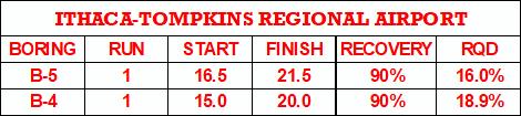
24 LOGGED BY D. ALLEN NOTES Kenney Geotechnical Engineering Services, PLLC 691 Herman Road DATE STARTED 4//18 COMPLETED 4//18 DRILLING CONTRACTOR Kenney Geotechnical Services DRILLING METHOD 3.2" HSA CHECKED BY CMK GROUND ELEVATION GROUND WATER LEVELS: AT TIME OF DRILLING 8. ft HOLE SIZE 8" AT END OF DRILLING 14.8 ft ; 4.8 ft AFTER ROCK CORING AFTER DRILLING 7.2 ft ; CAVE AT 11.9 ft BORING NUMBER B-4 PAGE 1 OF 1 DEPTH (ft) GRAPHIC LOG MATERIAL DESCRIPTION ASPHALT (SW) GRAY-BROWN VERY DENSE WELL-GRADED GRAVELLY SAND, MOIST SAMPLE TYPE NUMBER 1 RECOVERY % (RQD) 4 BLOW COUNTS (N VALUE) (41) POCKET PEN. (tsf) VOC (ppm) N VALUE PL MC LL FINES CONTENT (%) GEOTECH BH PLOTS - GINT STD US LAB.GDT - 7/12/18 8:3 - C:\PROGRAM FILES (X86)\GINT\PROJECTS\ ITHACA-TOMPKINS REGIONAL AIRPORT.GPJ 1 2 (SM) BROWN MEDIUM DENSE SILTY SAND WITH GRAVEL, MOIST (GM) BROWN DENSE SILTY GRAVEL WITH SAND, MOIST WEATHERED SHALE FRAGMENTS PRESENT (SC) OLIVE-BROWN CLAYEY SAND WITH GRAVEL, MOIST INCREASED WEATHERED SHALE FRAGMENTS PRESENT OLIVE BROWN HIGHLY WEATHERED SHALE GRADE IV PARTINGS OF SILTY LEAN CLAY PRESENT OLIVE-GRAY MODERATELY WEATHERED SHALE GRADE III RUN 1-1.' TO 2.' RECOVERY = 9%. RQD = 18.9% FRESH GRAY-BLUE ITHACA FORMATION SHALE Refusal at 1. feet. Bottom of borehole at 2. feet RC (19) (26) () (21) () -6- /" >>
25 LOGGED BY D. ALLEN NOTES Kenney Geotechnical Engineering Services, PLLC 691 Herman Road DATE STARTED 4//18 COMPLETED 4//18 DRILLING CONTRACTOR Kenney Geotechnical Services DRILLING METHOD 3.2" HSA CHECKED BY CMK GROUND ELEVATION GROUND WATER LEVELS: AT TIME OF DRILLING --- DRY HOLE SIZE 8" AT END OF DRILLING 1.8 ft ; 6.2 ft AFTER ROCK CORING AFTER DRILLING 7.2 ft ; CAVE AT 12.3 ft BORING NUMBER B- PAGE 1 OF 1 DEPTH (ft) GRAPHIC LOG MATERIAL DESCRIPTION ASPHALT (SW) GRAY-BROWN DENSE WELL-GRADED GRAVELLY SAND, MOIST SAMPLE TYPE NUMBER 1 RECOVERY % (RQD) 3 BLOW COUNTS (N VALUE) (43) POCKET PEN. (tsf) VOC (ppm) N VALUE PL MC LL FINES CONTENT (%) GEOTECH BH PLOTS - GINT STD US LAB.GDT - 7/12/18 8:3 - C:\PROGRAM FILES (X86)\GINT\PROJECTS\ ITHACA-TOMPKINS REGIONAL AIRPORT.GPJ 1 2 (GW) GRAY-BROWN VERY DENSE WELL-GRADED SANDY GRAVEL, MOIST (ML) BROWN DENSE SANDY SILT WITH GRAVEL, MOIST (GW) BROWN MEDIUM DENSE WELL-GRADED SANDY GRAVEL WITH SILT, MOIST POSSIBLE COBBLE AT ~6' (ML) OLIVE-BROWN STIFF SANDY SILT WITH CLAY, MOIST OLIVE-BROWN HIGHLY WEATHERED SHALE GRADE IV PARTINGS OF SILTY LEAN CLAY PRESENT RUN 1-16.' TO 21.' RECOVERY = 9%. RQD = 16.% FRESH GRAY-BLUE ITHACA FORMATION SHALE Refusal at 16. feet. Bottom of borehole at 21. feet RC (16) (68) (39) (2) (11) (22)

26 LOGGED BY D. ALLEN NOTES Kenney Geotechnical Engineering Services, PLLC 691 Herman Road DATE STARTED 4/9/18 COMPLETED 4/9/18 DRILLING CONTRACTOR Kenney Geotechnical Services DRILLING METHOD 3.2" HSA CHECKED BY CMK GROUND ELEVATION GROUND WATER LEVELS: AT TIME OF DRILLING 8. ft AT END OF DRILLING --- DRY HOLE SIZE 8" AFTER DRILLING 8.3 ft ; CAVE AT 8.7 ft BORING NUMBER B-6 PAGE 1 OF 1 DEPTH (ft) GRAPHIC LOG MATERIAL DESCRIPTION (ML) TOPSOIL: BROWN SOFT SANDY SILT WITH CLAY, MOIST (CL-ML) BROWN MEDIUM STIFF SILTY LEAN CLAY WITH SAND, MOIST SAMPLE TYPE NUMBER 1 RECOVERY % (RQD) 2 BLOW COUNTS (N VALUE) (6) POCKET PEN. (tsf) VOC (ppm) N VALUE PL MC LL FINES CONTENT (%) GEOTECH BH PLOTS - GINT STD US LAB.GDT - 7/12/18 8:3 - C:\PROGRAM FILES (X86)\GINT\PROJECTS\ ITHACA-TOMPKINS REGIONAL AIRPORT.GPJ 1 (SC) GRAY MEDIUM DENSE CLAYEY SAND WITH GRAVEL, MOIST (SM) OLIVE-BROWN MEDIUM DENSE SILTY SAND WITH GRAVEL, MOIST (SM) OLIVE-BROWN MEDIUM DENSE SILTY SAND WITH GRAVEL, MOIST WEATHERED SHALE FRAGMENTS PRESENT (SM) OLIVE-BROWN MEDIUM DENSE SILTY SAND WITH GRAVEL, WET INCREASED WEATHERED SHALE FRAGMENTS PRESENT OLIVE-BROWN HIGHLY WEATHERED SHALE GRADE IV OLIVE-GRAY SLIGHTLY WEATHERED SHALE GRADE II Refusal at 17. feet. Bottom of borehole at 17.4 feet (2) (19) (3) () (38) /" >>


27
28 Kenney Geotechnical Engineering Services, PLLC 691 Herman Road GRAIN SIZE DISTRIBUTION GRAIN SIZE - GINT STD US LAB.GDT - 7/12/18 14:39 - C:\PROGRAM FILES (X86)\GINT\PROJECTS\ ITHACA-TOMPKINS REGIONAL AIRPORT.GPJ PERCENT FINER BY WEIGHT U.S. SIEVE OPENING IN INCHES U.S. SIEVE NUMBERS HYDROMETER /4 1/23/ GRAIN SIZE IN MILLIMETERS COBBLES GRAVEL SAND coarse fine coarse medium fine SILT OR CLAY Specimen Identification Classification LL PL PI Cc Cu AB-2 6. Specimen Identification D D6 D3 D %Gravel %Sand %Silt %Clay AB
29 Kenney Geotechnical Engineering Services, PLLC 691 Herman Road GRAIN SIZE DISTRIBUTION GRAIN SIZE - GINT STD US LAB.GDT - 4/17/18 13:2 - C:\PROGRAM FILES (X86)\GINT\PROJECTS\ ITHACA-TOMPKINS REGIONAL AIRPORT.GPJ PERCENT FINER BY WEIGHT COBBLES Specimen Identification B-1 U.S. SIEVE OPENING IN INCHES U.S. SIEVE NUMBERS /4 1/23/ coarse 13. GRAVEL fine 1 GRAIN SIZE IN MILLIMETERS coarse medium SAND Classification SILTY GRAVEL WITH SAND (GM).1.1 SILT OR CLAY LL PL.1 PI Cc Cu Specimen Identification D D6 D3 D %Gravel %Sand %Silt %Clay B fine HYDROMETER
30 Kenney Geotechnical Engineering Services, PLLC 691 Herman Road GRAIN SIZE DISTRIBUTION GRAIN SIZE - GINT STD US LAB.GDT - 4/17/18 13:2 - C:\PROGRAM FILES (X86)\GINT\PROJECTS\ ITHACA-TOMPKINS REGIONAL AIRPORT.GPJ PERCENT FINER BY WEIGHT COBBLES Specimen Identification B-2 U.S. SIEVE OPENING IN INCHES U.S. SIEVE NUMBERS /4 1/23/ coarse 7. GRAVEL fine 1 GRAIN SIZE IN MILLIMETERS coarse medium SAND Classification SILTY SAND WITH GRAVEL (SM).1.1 SILT OR CLAY LL PL.1 PI Cc Cu Specimen Identification D D6 D3 D %Gravel %Sand %Silt %Clay B fine HYDROMETER
31 Kenney Geotechnical Engineering Services, PLLC 691 Herman Road GRAIN SIZE DISTRIBUTION GRAIN SIZE - GINT STD US LAB.GDT - 4/17/18 13:2 - C:\PROGRAM FILES (X86)\GINT\PROJECTS\ ITHACA-TOMPKINS REGIONAL AIRPORT.GPJ PERCENT FINER BY WEIGHT COBBLES Specimen Identification B-3 U.S. SIEVE OPENING IN INCHES U.S. SIEVE NUMBERS /4 1/23/ coarse. GRAVEL fine 1 GRAIN SIZE IN MILLIMETERS coarse medium SAND Classification SILTY GRAVEL WITH SAND (GM).1.1 SILT OR CLAY LL PL.1 PI Cc Cu Specimen Identification D D6 D3 D %Gravel %Sand %Silt %Clay B fine HYDROMETER
32 Kenney Geotechnical Engineering Services, PLLC 691 Herman Road GRAIN SIZE DISTRIBUTION GRAIN SIZE - GINT STD US LAB.GDT - 4/17/18 13:42 - C:\PROGRAM FILES (X86)\GINT\PROJECTS\ ITHACA-TOMPKINS REGIONAL AIRPORT.GPJ PERCENT FINER BY WEIGHT COBBLES Specimen Identification B-4 U.S. SIEVE OPENING IN INCHES U.S. SIEVE NUMBERS /4 1/23/ coarse 6. GRAVEL fine 1 GRAIN SIZE IN MILLIMETERS coarse medium SAND Classification SILTY GRAVEL WITH SAND (GM).1.1 SILT OR CLAY LL PL.1 PI Cc Cu Specimen Identification D D6 D3 D %Gravel %Sand %Silt %Clay B fine HYDROMETER
33 Kenney Geotechnical Engineering Services, PLLC 691 Herman Road GRAIN SIZE DISTRIBUTION GRAIN SIZE - GINT STD US LAB.GDT - 4/17/18 13:2 - C:\PROGRAM FILES (X86)\GINT\PROJECTS\ ITHACA-TOMPKINS REGIONAL AIRPORT.GPJ PERCENT FINER BY WEIGHT COBBLES Specimen Identification B- U.S. SIEVE OPENING IN INCHES U.S. SIEVE NUMBERS /4 1/23/ coarse 6. GRAVEL fine 1 GRAIN SIZE IN MILLIMETERS coarse medium SAND Classification SANDY SILT WITH GRAVEL (MLS).1.1 SILT OR CLAY LL PL.1 PI Cc Cu Specimen Identification D D6 D3 D %Gravel %Sand %Silt %Clay B fine HYDROMETER
34 Kenney Geotechnical Engineering Services, PLLC 691 Herman Road GRAIN SIZE DISTRIBUTION GRAIN SIZE - GINT STD US LAB.GDT - 4/17/18 13:21 - C:\PROGRAM FILES (X86)\GINT\PROJECTS\ ITHACA-TOMPKINS REGIONAL AIRPORT.GPJ PERCENT FINER BY WEIGHT COBBLES Specimen Identification B-6 U.S. SIEVE OPENING IN INCHES U.S. SIEVE NUMBERS /4 1/23/ coarse 3. GRAVEL fine 1 GRAIN SIZE IN MILLIMETERS coarse medium SAND Classification CLAYEY SAND WITH GRAVEL (SC).1.1 SILT OR CLAY LL PL.1 PI Cc Cu Specimen Identification D D6 D3 D %Gravel %Sand %Silt %Clay B fine HYDROMETER
 B-1 12' - 14' 9.1 B-2 6' - 8'.4 B-3 4' - 6' 8. B-4 6' - 8' 12.")
35 Kenney Geotechnical Engineering Services, PLLC Office: 691 Herman Road, Syracuse, N.Y Mail: P.O. Box 16 Baldwinsville, N.Y Phone: (31) Fax: (31) Project No.: Project Name: Ithaca-Tompkins Regional Airport Expansion Natural Moisture Content ASTM D22116 Boring Depth Moisture Content (%) B-1 12' - 14' 9.1 B-2 6' - 8'.4 B-3 4' - 6' 8. B-4 6' - 8' 12.4 B- 4' - 6' 8.8 B-6 2' - 4'.6 AB-2 4' - 6' 9.6
 Photo 1 - Southerly view across 2700 parking lot toward existing building. Multi-residential building borders western side of property in upper right of view. Photo 2 - Southerly view across 2750 parking
 SOIL CLASSIFICATION CHART COARSE-GRAINED SOILS MORE THAN 50% RETAINED ON NO.200 SIEVE FINE-GRAINED SOILS 50% OR MORE PASSES THE NO.200 SIEVE PRIMARY DIVISIONS GRAVELS MORE THAN 50% OF COARSE FRACTION RETAINED
APPENDIX A. Borehole Logs Explanation of Terms and Symbols
 APPENDIX A Borehole Logs Explanation of Terms and Symbols Page 153 of 168 EXPLANATION OF TERMS AND SYMBOLS The terms and symbols used on the borehole logs to summarize the results of field investigation
Solution:Example 1. Example 2. Solution: Example 2. clay. Textural Soil Classification System (USDA) CE353 Soil Mechanics Dr.
 CE353 Soil Mechanics Dr.") CE353 Soil Mechanics CE353 Lecture 5 Geotechnical Engineering Laboratory SOIL CLASSIFICATION Lecture 5 SOIL CLASSIFICATION Dr. Talat A Bader Dr. Talat Bader 2 Requirements of a soil Systems Why do we need
CE353 Soil Mechanics CE353 Lecture 5 Geotechnical Engineering Laboratory SOIL CLASSIFICATION Lecture 5 SOIL CLASSIFICATION Dr. Talat A Bader Dr. Talat Bader 2 Requirements of a soil Systems Why do we need
Field Exploration. March 31, J-U-B ENGINEERS, Inc. 115 Northstar Avenue Twin Falls, Idaho Attn: Mr. Tracy Ahrens, P. E. E:
 March 31, 201 11 Northstar Avenue 83301 Attn: Mr. Tracy Ahrens, P. E. E: taa@jub.com Re: Geotechnical Data Report Preliminary Phase 1 Field Exploration Revision No. 1 Proposed Rapid Infiltration Basin
B-1 BORE LOCATION PLAN. EXHIBIT Drawn By: 115G BROOKS VETERINARY CLINIC CITY BASE LANDING AND GOLIAD ROAD SAN ANTONIO, TEXAS.
 N B-1 SYMBOLS: Exploratory Boring Location Project Mngr: BORE LOCATION PLAN Project No. GK EXHIBIT Drawn By: 115G1063.02 GK Scale: Checked By: 1045 Central Parkway North, Suite 103 San Antonio, Texas 78232
CE 240 Soil Mechanics & Foundations Lecture 3.2. Engineering Classification of Soil (AASHTO and USCS) (Das, Ch. 4)
 (Das, Ch. 4)") CE 240 Soil Mechanics & Foundations Lecture 3.2 Engineering Classification of Soil (AASHTO and USCS) (Das, Ch. 4) Outline of this Lecture 1. Particle distribution and Atterberg Limits 2. Soil classification
CE 240 Soil Mechanics & Foundations Lecture 3.2 Engineering Classification of Soil (AASHTO and USCS) (Das, Ch. 4) Outline of this Lecture 1. Particle distribution and Atterberg Limits 2. Soil classification
Depth (ft) USCS Soil Description TOPSOIL & FOREST DUFF
 USCS Soil Description TOPSOIL & FOREST DUFF") Test Pit No. TP-6 Location: Latitude 47.543003, Longitude -121.980441 Approximate Ground Surface Elevation: 1,132 feet Depth (ft) USCS Soil Description 0 1.5 1.5 5.0 SM 5.0 8.0 SM Loose to medium dense,
Test Pit No. TP-6 Location: Latitude 47.543003, Longitude -121.980441 Approximate Ground Surface Elevation: 1,132 feet Depth (ft) USCS Soil Description 0 1.5 1.5 5.0 SM 5.0 8.0 SM Loose to medium dense,
APPENDIX C HYDROGEOLOGIC INVESTIGATION
 Figure B-5.7 Figure B-5.8 Preliminary Geotechnical and Environmental Report Appendix C Hydrogeologic Investigation APPENDIX C HYDROGEOLOGIC INVESTIGATION December 21, 2011 WESTSIDE SUBWAY EXTENSION PROJECT
Civil Engineering, Surveying and Environmental Consulting WASP0059.ltr.JLS.Mich Ave Bridge Geotech.docx
 2365 Haggerty Road South * Canton, Michigan 48188 P: 734-397-3100 * F: 734-397-3131 * www.manniksmithgroup.com August 29, 2012 Mr. Richard Kent Washtenaw County Parks and Recreation Commission 2330 Platt
APPENDIX C. Borehole Data
 APPENDIX C Borehole Data MAJOR DIVISIONS SOIL CLASSIFICATION CHART SYMBOLS GRAPH LETTER TYPICAL DESCRIPTIONS ADDITIONAL MATERIAL
APPENDIX A GEOTECHNICAL REPORT
 The City of Winnipeg Bid Opportunity No. 529-2017 Template Version: C420170317 - RW APPENDIX A GEOTECHNICAL REPORT Quality Engineering Valued Relationships KGS Group 2017 Industrial Street Rehabilitation
Geotechnical Data Report
 Geotechnical Data Report ReWa Solar Farm at Durbin Creek Fountain Inn, South Carolina September 1, 2017 Terracon Project No. 86165043 Prepared for: Renewable Water Resources Greenville, South Carolina
CITY OF VALDEZ Project Title: East Pioneer Reconstruction Project No.: Contract No.: TO: All Recipients Date: April 14, 2014
 CITY OF VALDEZ Project Title: East Pioneer Reconstruction Project No.: 13-3-1.32 Contract No.: 11 TO: All Recipients Date: April 14, 214 SUBJECT: Addendum No.1 This seventeen (17) page Addendum forms a
ADDENDUM 1 FISHER SLOUGH RESTORATION PROJECT SKAGIT COUNTY, WASHINGTON
 F I N A L A D D E N D U M 1 R E P O R T ADDENDUM 1 FISHER SLOUGH RESTORATION PROJECT SKAGIT COUNTY, WASHINGTON REPORT OF GEOTECHNICAL INVESTIGATION URS JOB NO. 3376186 Prepared for Tetra Tech Inc. 142
Clay Robinson, PhD, CPSS, PG copyright 2009
 Engineering: What's soil got to do with it? Clay Robinson, PhD, CPSS, PG crobinson@wtamu.edu, http://www.wtamu.edu/~crobinson, copyright 2009 Merriam-Webster Online Dictionary soil, noun 1 : firm land
December 5, Junction Gateway, LLC 7551 W. Sunset Boulevard #203 Los Angeles, CA Mr. James Frost P: Dear Mr.
 December 5, 2014 Junction Gateway, LLC 7551 W. Sunset Boulevard #203 90046 Attn: Re: Mr. James Frost P: 323.883.1800 Geotechnical Update Letter Sunset & Effie Mixed Use Development 4301 to 4311 Sunset
 FIGURES 200 200 200 SW 175TH AVE 350 SW SCHOLLS FERRY RD SW FRIENDLY LN Area 64 SW ROY ROGERS RD 300 250 SW ONEILL CT SW LUKE LN SW LEEDING LN SW TUSCANY ST SW 164TH AVE SW BULL MOUNTAIN RD SW 164TH AVE
EIGHT POINT WIND LLC
 GEOTECHNICAL INVESTIGATION REPORT EIGHT POINT WIND FARM SUBSTATION AND OPERATION AND MAINTENANCE FACILITY STEUBEN COUNTY NEW YORK PREPARED FOR EIGHT POINT WIND LLC 700 UNIVERSE BLVD. JUNO BEACH, FL 33408
GEOTECHNICAL REPORT. Matanuska-Susitna Borough. Parks Highway Connections Museum Drive. Matanuska-Susitna Borough, Alaska.
 Matanuska-Susitna Borough GEOTECHNICAL REPORT Parks Highway Connections Museum Drive Matanuska-Susitna Borough, Alaska March 2, 20 Prepared By: John Thornley, PE Geotechnical Engineer 333 Arctic Blvd.,
Parsons APPENDIX A BORING LOGS AND DEVELOPMENT LOG
 Parsons APPENDIX A BORING LOGS AND DEVELOPMENT LOG GEOLOGIC LOG DATE STARTED: DATE COMPLETED: 08-Sep-09 08-Sep-09 LOGGER: Quin Kinnebrew WEATHER: Clear & Warm PAGE 1 OF 2 WELL NO. GMW-66 COMPANY NAME:
Tikrit University College of Engineering Civil engineering Department
 Tikrit University SOIL CLASSIFICATION College of Engineering Civil engineering Department Soil Mechanics 3 rd Class Lecture notes Up Copyrights 2016 Classification of soil is the separation of soil into
Dashed line indicates the approximate upper limit boundary for natural soils. C L o r O L C H o r O H
 SYMBOL SOURCE 8 9 1 SOIL DATA NATURAL SAMPLE DEPTH WATER PLASTIC LIQUID PLASTICITY NO. CONTENT LIMIT LIMIT INDEX (%) (%) (%) (%) Client: County of Berthoud Project: Project No.: Boring B-2 S-1-5' 6.2 8
New WW Hastings Hospital Geotechnical Investigation RFP Addendum #1
 88 E. Marshall Street, Suite 0 Tulsa, OK 76 98 8 9 Phone 98 8 798 FAX DATE: April 9, 0 ADDENDUM NO.: PROJECT: New WW Hastings Hospital BID PACKAGE NO: Geotechnical Investigation RFP SUBMITTED BY: CNCR
Geotechnical Engineering Report
 Geotechnical Engineering Report Single-Span Bridge North Western Road & Hall of Fame Avenue August 25, 2015 Terracon Project No. 03155156 Prepared for: Olsson Associates Prepared by: Terracon Consultants,
Geotechnical Engineering Report
 Geotechnical Engineering Report Turner Turnpike Widening Bridge B Bridge Crossing: South 257 th West Avenue Creek County, Oklahoma June 1, 2016 Terracon Project No. 04155197 Prepared for: Garver, LLC Tulsa,
 TP-1 N61E 0 DARK BROWN SANDY SILT (ML) stiff, wet with roots (Disturbed Surficial Soil) DEPTH (FEET) 5 REDDISH BROWN SANDSTONE intensely fractured, weak to friable, deeply weathered, tight (Franciscan
SOIL FORMATION SOIL CLASSIFICATION FOR GEOTECHNICAL ENGINEERS. Soil Properties and Classification
 SOIL CLASSIFICATION FOR GEOTECHNICAL ENGINEERS Soil Properties and Classification Soil Formation Soil Types Particle Size Analysis and Grading Characteristics Consistency Indices Engineering classification
REPORT OF PRELIMINARY SUBSURFACE EXPLORATION. VCU Basketball Practice Facility 1300/1328 West Marshall Street City of Richmond, Virginia.
 REPORT OF PRELIMINARY SUBSURFACE EXPLORATION VCU Basketball Practice Facility 100/18 West Marshall Street City of Richmond, Virginia For Mr. Carl F. Purdin, AIA Assistant Director of Design Services VCU
DATA REPORT GEOTECHNICAL INVESTIGATION GALVESTON CRUISE TERMINAL 2 GALVESTON, TEXAS
 DATA REPORT GEOTECHNICAL INVESTIGATION GALVESTON CRUISE TERMINAL 2 GALVESTON, TEXAS SUBMITTED TO PORT OF GALVESTON 123 ROSENBERG AVENUE, 8TH FLOOR GALVESTON, TEXAS 77553 BY HVJ ASSOCIATES, INC. HOUSTON,
PRELIMINARY GEOTECHNICAL ENGINEERING REPORT
 PRELIMINARY GEOTECHNICAL ENGINEERING REPORT TOWN OF ASHLAND TOWN HALL 101 THOMPSON STREET ASHLAND, VIRGINIA JOB NUMBER: 39016 PREPARED FOR: PMA PLANNERS & ARCHITECTS 10325 WARWICK BOULEVARD NEWPORT NEWS,
Geotechnical Data Report
 Geotechnical Data Report Downtown Greenville Future Conveyance Study December 1, 2015 Terracon Project No. 86155032 Prepared for: Prepared by: Terracon Consultants, Inc. December 1, 2015 561 Mauldin Road
B-1 SURFACE ELEVATION
 5A 5B LOGGED BY El. S. Bhangoo DRILLING CONTRACTOR Pitcher Drilling DRILLING METHOD Rotary Wash BEGIN DATE 12-14-12 SAMPLER TYPE(S) AND SIZE(S) (ID) SPT, MC BOREHOLE BACKFILL AND COMPLETION COMPLETION
AN EMPLOYEE OWNED COMPANY
 CTL Engineering, Inc. 2860 Fisher Road, P.O. Box 4448, Columbus, Ohio 43204338 Phone: 614/2768123 Fax: 614/2766377 Email: ctl@ctleng.com AN EMPLOYEE OWNED COMPANY Consulting Engineers Testing Inspection
DRILL HOLE # BH-BGC13-FN-01
 DILL HOLE # BH-BGC3-FN-0 Drill Method: Mud otary/coring Depth To ock (m): N/A Page of 7 eviewed by: AJB 0 GAVEL (GW) Fine to coarse, sandy, well graded, dense, max particle size = 30 mm, angular to subrounded,
Northern Colorado Geotech
 PRELIMINARY GEOTECHNICAL ENGINEERING REPORT PROPOSED CECIL FARMS DEVELOPMENT WELD COUNTY ROAD 7, BETWEEN ROADS 7 AND 7 SEVERANCE, COLORADO NORTHERN COLORADO GEOTECH PROJECT NO. 0-6 APRIL 0, 06 Prepared
December 13, Washington County Public Works Department Myeron Road North Stillwater, MN Attn: Mr. Andrew Giesen
 CONSULTANTS ENVIRONMENTAL GEOTECHNICAL MATERIALS FORENSICS December 13, 2016 Washington County Public Works Department 11660 Myeron Road North Stillwater, MN 55082 Attn: Mr. Andrew Giesen RE: Geotechnical
GZA GeoEnvironmental, Inc.
 GZA BORING NO.: GZ-1 SHEET: 1 of 1 PROJECT NO: 9.223. Drilling Co.: Geologic Type of Rig: Skid Boring Location: See Plan H. Datum: See Plan Rig Model: Mudline : Foreman: Ray Eastwood CME -.8 Final Boring
Geotechnical Engineering Report
 Geotechnical Engineering Report Turner Turnpike Widening Polecat Creek Bridge (Bridge A) June 1, 2016 Terracon Project No. 04155197 Prepared for: Garver, LLC Prepared by: Terracon Consultants, Inc. TABLE
Appendix G GEOLOGICAL INVESTIGATION
 Appendix G GEOLOGICAL INVESTIGATION JOB NUMBER: 3268.001 DATE: 10-14-13 BY: CC SITE 0 2000 1"=2000' VICINITY MAP CARGILL PARCEL HICKORY STREET AND ENTERPRISE DRIVE NEWARK, CALIFORNIA FOR
Correlation of unified and AASHTO soil classification systems for soils classification
 Journal of Earth Sciences and Geotechnical Engineering, vol. 8, no. 1, 2018, 39-50 ISSN: 1792-9040 (print version), 1792-9660 (online) Scienpress Ltd, 2018 Correlation of unified and AASHTO classification
Project No: 68R3056 Client: City of Frederick Project: RFQ 14-H Future North Side Water Tank City/State: 7516 Hayward Road, Frederick, MD
 Boring: SB-1 (1 of 1) Moist, brown to orange brown CLAY and SILT, trace sand with fine weathered rock fragments. POSSIBLE FILL. Dry, orange brown sandy SILT trace clay (SM-ML). RESIDUAL SOIL : Not Surveyed
Report of Preliminary Geotechnical Exploration. CSO-012 Sewer Separation Cincinnati, Hamilton County, Ohio. February, 2011
 11242843_GeoTech_Preliminary - Feburary 2011_1/40 Report of Preliminary Geotechnical Exploration CSO-012 Sewer Separation Cincinnati, Hamilton County, Ohio February, 2011 11242843_GeoTech_Preliminary -
ENGINEERING ASSOCIATES
 July 16, 211 Vista Design, Inc. 11634 Worcester Highway Showell, Maryland 21862 Attention: Reference: Dear Mr. Polk: Mr. Richard F. Polk, P.E. Geotechnical Engineering Report Charles County RFP No. 11-9
Technical Memorandum. Soil Borings
 Technical Memorandum To: Project File and Appendix F to Sediment Remedial Investigation Report From: Sara L. Leow, PE Subject: Geotechnical Investigation and Results Summary Date: February 213 Project:
Soil Mechanics Brief Review. Presented by: Gary L. Seider, P.E.
 Soil Mechanics Brief Review Presented by: Gary L. Seider, P.E. 1 BASIC ROCK TYPES Igneous Rock (e.g. granite, basalt) Rock formed in place by cooling from magma Generally very stiff/strong and often abrasive
PRELIMINARY GEOTECHNICAL REPORT. State College Redevelopment State College Borough, Centre County, Pennsylvania. CMT Laboratories File No.
 PRELIMINARY GEOTECHNICAL REPORT State College Redevelopment State College Borough, Centre County, Pennsylvania CMT Laboratories File No. 1638700 Prepared for: National Development Council One Battery Park
February 16, 2015 File No Ms. Robin Yates TRC Engineers Inc N. Fresno Street, Suite 200 Fresno, California 93710
 February 16, 2015 File No. 20152738 Ms. Robin Yates TRC Engineers Inc. 6051 N. Fresno Street, Suite 200 Fresno, California 93710 SUBJECT: Geotechnical Design Memorandum Fresno BPMP Scour Countermeasure
Limited Geotechnical Engineering Evaluation Classroom Additions Albany County Campus Laramie, Wyoming
 Limited Geotechnical Engineering Evaluation Classroom Additions Albany County Campus 2300 Missile Drive, Cheyenne, Wyoming 82001 Phone 307-635-0222 www.stratageotech.com Limited Geotechnical Engineering
APPENDIX B: BORING LOGS
 New Orleans Levee Systems Independent Levee Hurricane Katrina Investigation Team July, 6 APPENDIX B: BORING S As part of the field investigation 9 borings were performed at the sites of interest, as listed
GEOLOGIC/GEOTECHNICAL INVESTIGATION FOR TENTATIVE MAP LAVENIDA SUBDIVISION (APN # ) ORINDA, CALIFORNIA
 ORINDA, CALIFORNIA") GEOLOGIC/GEOTECHNICAL INVESTIGATION FOR TENTATIVE MAP LAVENIDA SUBDIVISION (APN #271-120-011) ORINDA, CALIFORNIA A 580 Ts 590 HMA-1 600 HMA-2 70 Ts 610 Ts HMA-3 HLA-5 GJA-6 LD-2 23
GEOLOGIC/GEOTECHNICAL INVESTIGATION FOR TENTATIVE MAP LAVENIDA SUBDIVISION (APN #271-120-011) ORINDA, CALIFORNIA A 580 Ts 590 HMA-1 600 HMA-2 70 Ts 610 Ts HMA-3 HLA-5 GJA-6 LD-2 23
Preliminary Geotechnical Investigation Cadiz / Trigg County I-24 Business Park. Cadiz, Kentucky
 Environmental & Geoscience, LLC 834 Madisonville Road Hopkinsville, KY 440 70.44.000 FAX 70.44.8300 www.wedrill.com A member of Trinity Energy & Infrastructure Group, LLC Preliminary Geotechnical Investigation
4. Soil Consistency (Plasticity) (Das, chapter 4)
 (Das, chapter 4)") 4. Soil Consistency (Plasticity) (Das, chapter 4) 1 What is Consistency? Consistency is a term used to describe the degree of firmness of fine-grained soils (silt and clay). The consistency of fine grained
4. Soil Consistency (Plasticity) (Das, chapter 4) 1 What is Consistency? Consistency is a term used to describe the degree of firmness of fine-grained soils (silt and clay). The consistency of fine grained
BR-01 PAINT BRIDGE NO. 55 C GENERAL PLAN 720'-0" VC 605'-0" VC 1. FOR INDEX TO PLANS, QUANTITIES, AND GENERAL NOTES, SEE "INDEX TO PLANS" SHEET.
 2'-" VC 6'-" VC BB EB 1 1 1 1 1 TV - " TV CONDUITS (COX E 8 - " ELECTRIC CONDUITS (SDG & E T - " TELEPHONE CONDUITS 1. FOR INDEX TO PLANS, QUANTITIES, AND GENERAL NOTES, SEE "INDEX TO PLANS" SHEET. 2.
Introduction to Soil Mechanics Geotechnical Engineering-II
 Introduction to Soil Mechanics Geotechnical Engineering-II ground SIVA Dr. Attaullah Shah 1 Soil Formation Soil derives from Latin word Solum having same meanings as our modern world. From Geologist point
Geotechnical Engineering Report
 Geotechnical Engineering Report SH-9 Bridge over Wewoka Creek Hughes County, Oklahoma Job Piece No. 27059(04) July 16, 2015 Terracon Project No. 04125055 Prepared for: Holloway, Updike, and Bellen, Inc.
Jim Christal Rd B2 B1 B3
 Jim Christal Rd B1 B2 B3 KEY O YMBOL AND ERM LIHOLOGIC YMBOL Asphalt ARIFICIAL Aggregate Base Concrete Fill CH: High Plasticity Clay CL: Low Plasticity Clay Consistency Very oft oft Medium tiff tiff Very
Geotechnical Recommendations for Proposed Additions to the Three Mile Creek Severe Weather Attenuation Tank Project
 TECHNICAL MEMORANDUM Geotechnical Recommendations for Proposed Additions to the Three Mile Creek Severe Weather Attenuation Tank Project PREPARED FOR: PREPARED BY: DATE: June 28, 218 PROJECT NUMBER: 697482
Geotechnical Engineering Report
 Geotechnical Engineering Report Richland Creek Trunk Sewer Greenville, South Carolina March 31, 2014 Terracon Project No. 86145008 Prepared for: Renewable Water Resources Greenville, South Carolina Prepared
NAPLES MUNICIPAL AIRPORT
 NAPLES MUNICIPAL AIRPORT NAPLES MUNICIPAL AIRPORT (APF) TAXIWAY D REALIGNMENT AND DRAINAGE IMPROVEMENTS NORTH QUADRANT ADDENDUM NUMBER TWO March, The following Addendum is hereby made a part of the Plans
Geotechnical Engineering Report
 Geotechnical Engineering Report Turner Turnpike Widening Bridge D Bridge Crossing: South 209 th West Avenue Creek County, Oklahoma June 1, 2016 Terracon Project No. 04155197 Prepared for: Garver, LLC Tulsa,
CONQUEST ENGINEERING LTD.
 CONQUEST ENGINEERING LTD. Geotechnical and Materials Engineers Concrete Technology, Blasting Consultants Construction Quality Assurance / Quality Control 8 Bluewater Road, Bedford, NS BB J6 Phone (9)85-7
DATE: 5/17/2012. LOGGED BY: Geoff Richards. COMPANY: Tetra Tech EM, Inc. DRILL FOREMAN: Walter
 ATTACHMENT 2 Page 1 of 1 B1 0 1 2 FILL, Dry; brownish red; clayey silt and gravel; ~30% gravel size fragments of dark grey microcrystalline (aphanetic), extrusive, igneous, rock 3 B1-4a 1100 B1-4b-duplicate
Ardaman & Associates, Inc. Geotechnical, Environmental and Materials Consultants
 SUBSURFACE SOIL EXPLORATION DRAINAGE IMPROVEMENTS TO THE HENDRY COUNTY, FLORIDA Ardaman & Associates, Inc. Geotechnical, Environmental and Materials Consultants OFFICES Orlando, 88 S. Orange Avenue, Orlando,
DYREGROV ROBINSON INC.
 DYREGROV ROBINSON INC. Consulting Geotechnical Engineers 101-1555 St. James Street Winnipeg, MB R3H 1B5 TEL (204) 632-7252 FAX (204) 632-1442 June 14, 2013 File No. 133583 Accutech Engineering Inc. 605-287
3.0 SUMMARY OF FINDINGS
 AECOM 500 W Jefferson St. Suite 1600 Louisville, KY 40202 www.aecom.com 502-569-2301 tel 502-569-2304 fax October 17, 2018 Big Rivers Electric Corporation Sebree Generating Station 9000 Highway 2096 Robards,
REPORT OF PRELIMINARY SUBSURFACE EXPLORATION, LABORATORY TESTING AND GEOTECHNICAL ENGINEERING ANALYSES
 REPORT OF PRELIMINARY SUBSURFACE EXPLORATION, LABORATORY TESTING AND GEOTECHNICAL ENGINEERING ANALYSES Maryland Masonic Home Cockeysville, Baltimore County, Maryland ECS Project No. 7 Prepared For BALTIMORE
patersongroup Design for Earthquakes Consulting Engineers May 19, 2016 File: PG3733-LET.01
 patersongroup May 19, 2016 File: PG3733-LET.01 Hydro Ottawa Limited c/o Cresa Toronto 170 University Avenue, Suite 1 Toronto, Ontario M5H 3B3 Attention: Ms. Barbara Wright Consulting Engineers 154 Colonnade
WELL NUMBER 14-BW03 PAGE 1 OF 5
 WELL 14-BW03 PAGE 1 OF 5 IENT PROJECT DATE STARTED 4/30/14 COMPLETED 5/1/14 GROUND ELEVATION 1157.89 ft HOLE SIZE 9 5/8 inches DRILLING CONTRACTOR Cascade Drilling NORTHING 670592.2 EASTING 1937845.8 DRILLING
GEOTECHNICAL EXPLORATION REPORT
 110001_Report_Geotech, 2/ GEOTECHNICAL EXPLORATION REPORT BENSON STREET SEWER REPLACEMENT READING, HAMILTON COUNTY, OHIO MSDGC PROJECT NO. 20031 PREPARED FOR AECOM 219 MALSBURY ROAD CINCINNATI, OHIO 22
Report of Geotechnical Data
 Report of Geotechnical Da NAMA Rehabilite Potable Wer Lines Washington, DC F&R Project No. 7U89 Prepared For: CHM Hill 87 Stony Point Parkway, Suite 11 Richmond, Virginia 335 Prepared By: Froehling & Robertson,
Geotechnical Data Report
 Geotechnical Data Report S-38-50 (Four Holes Road) over I-26 Emergency Bridge Replacement Orangeburg County, South Carolina May 22, 2018 (Revision 1) SCDOT Project ID.: P037465 Terracon Project No. 73155050U
SUPPLEMENTARY INVESTIGATION AND LABORATORY TESTING Aggregate Resource Evaluation Proposed Bernand Quarry San Diego County, California
 October 3, 2 Mr. Mark San Agustin Project No. 28-- Home Land Investments Document No. -92 2239 Curlew Street San Diego, CA 92 SUBJECT: SUPPLEMENTARY INVESTIGATION AND LABORATORY TESTING Aggregate Resource
Assessment of accuracy in determining Atterberg limits for four Iraqi local soil laboratories
 IOP Conference Series: Materials Science and Engineering PAPER OPEN ACCESS Assessment of accuracy in determining Atterberg limits for four Iraqi local soil laboratories To cite this article: H O Abbas
Appendix F Laboratory test results
 Appendix F Laboratory test results SOIL AND ROCK SAMPLE ANALYSIS LABORATORY TEST REPORT To: Bord Gais Copy: Orla Smyth (kkidd@bge.ie) From: Stephen Watson Laboratory Manager Causeway Geotech Ltd Tel: +44(0)2827666640
GEOTECHNICAL ENGINEERING SERVICES REPORT
 GEOTECHNICAL ENGINEERING SERVICES REPORT BRIDGE OVER BIG CREEK APPROXIMATELY.8 MILES EAST OF THE INTERSECTION OF COUNTY ROAD EW1546 AND COUNTY ROAD 193 LEFLORE COUNTY, OKLAHOMA PROJECT No. J2-8616(5),
PREPARED FOR MR. JOE WOOD CARTER & SLOOPE, INC PEAKE ROAD MACON, GEORGIA PREPARED BY
 SUBSURFACE EXPLORATION AND GEOTECHNICAL ENGINEERING EVALUATION MACON WATER AUTHORITY (MWA) SANITARY SEWER RELOCATION MACON, GEORGIA GEC PROJECT NO. 14077.2 PREPARED FOR MR. JOE WOOD CARTER & SLOOPE, INC.
Appendix A. Producer Statement Advisory Note
 Appendix A Producer Statement Advisory Note Ref. No. 17095 26 May 2017 PRODUCER STATEMENT CONSTRUCTION REVIEW (PS4) IMPORTANT ADVISORY NOTE The Building Consent Authority (BCA) frequently requires Producer
Dry Muliwai Sample Location Map
 DMM2 DMM1 P:\AthruR\K838-Makua\GIS\Layouts\Dry Muliwai.mxd.mxd - 3/26/3 - JC DMM3 5 Dry Muliwai Sample Location Map Figure 2-4 P:\AthruR\K838-Makua\GIS\Layouts\orth Background Muliwai.mxd.mxd - 3/26/3
Geotechnical Data Report
 Geotechnical Data Report Emergency Bridge Package 6 Richland County, South Carolina May 12, 2016 SCDOT Project ID.: P029942, P029943, P029944 Terracon Project No. 73100L (Rev. 1) Prepared for: South Carolina
Geotechnical Investigation
 Geotechnical Investigation Slope Stability Analysis for the Existing Slope Southwest of the Proposed Condo Developments 50 Ann Street, Bolton, Ontario Prepared For: Brookfield Homes (Ontario) Limited GeoPro
GEOTECHNICAL INVESTIGATION
 GEOTECHNICAL INVESTIGATION I-80 WILDLIFE OVERCROSSING @ SILVER ZONE PASS ELKO COUNTY, NEVADA EA #73438 JULY 2011 MATERIALS DIVISION Table of Contents 1.0 INTRODUCTION... 1 2.0 PROJECT DESCRIPTION... 1
CIVE.5370 EXPERIMENTAL SOIL MECHANICS Soil Sampling, Testing, & Classification Review
 DATA COLLECTION, INTERPRETATION, & ANALYSIS TO GEOTECHNICAL SOLUTIONS FLOW CHART PRIOR INFORMATION Reconnaissance Topography Geology Hydrology Environment SITE EXPLORATION Geophysics Drilling and Coring
IN SITU SPECIFIC GRAVITY VS GRAIN SIZE: A BETTER METHOD TO ESTIMATE NEW WORK DREDGING PRODUCTION
 IN SITU SPECIFIC GRAVITY VS GRAIN SIZE: A BETTER METHOD TO ESTIMATE NEW WORK DREDGING PRODUCTION Nancy Case O Bourke, PE 1, Gregory L. Hartman, PE 2 and Paul Fuglevand, PE 3 ABSTRACT In-situ specific gravity
GEOTECHNICAL INVESTIGATION REPORT
 GEOTECHNICAL INVESTIGATION REPORT SOIL INVESTIGATION REPORT FOR STATIC TEST FACILITY FOR PROPELLANTS AT BDL, IBRAHIMPATNAM. Graphics Designers, M/s Architecture & Engineering 859, Banjara Avenue, Consultancy
Geotechnical Subsurface Exploration and Laboratory Testing Data Report
 Geotechnical Subsurface Exploration and Laboratory Testing Data Report 2016 1A Emergency Bridge Replacement Package SCDOT PIN P030784 S 13 (East National Cemetery Road) Bridge over Long Branch Florence
Geotechnical Engineering Report
 Geotechnical Engineering Report SH-10 Bridge Over Council Hollow Creek Ottawa County, Oklahoma Project No. STPY-255F (191) EC Job Piece No. 30308 (06) April 1, 2015 Terracon Project No. 04155008 Prepared
Appendix J. Geological Investigation
 Appendix J Geological Investigation Appendix J Geological Environment Table of Contents Page 1 INTRODUCTION...J-1 1.1 Purpose of the Investigation...J-1 1.2 Scope of the Investigation...J-1 2 METHODO OF
Sci.Int (Lahore), 25(4), , 2013 ISSN ; CODEN: SINTE 8 531
, 25(4), , 2013 ISSN ; CODEN: SINTE 8 531") Sci.Int (Lahore), 25(4),531-537, 2013 ISSN 1013-5316; CODEN: SINTE 8 531 PROFILING AND ZONING OF GEOTECHNICAL SUB-SOIL DATA USING GEOGRAPHIC INFORMATION SYSTEM Mahmood Ahmad*, Qaiser Iqbal and Fayaz Ahmad
Sci.Int (Lahore), 25(4),531-537, 2013 ISSN 1013-5316; CODEN: SINTE 8 531 PROFILING AND ZONING OF GEOTECHNICAL SUB-SOIL DATA USING GEOGRAPHIC INFORMATION SYSTEM Mahmood Ahmad*, Qaiser Iqbal and Fayaz Ahmad
Geotechnical Engineering Report
 REPORT COVER PAGE Geotechnical Engineering Report Proposed T-Line Structure Tahlequah, Oklahoma October 17, 2018 Terracon Project No. 04185192 Prepared for: GRDA Tulsa, Oklahoma Prepared by: Terracon Consultants,
PRELIMINARY GEOTECHNICAL ENGINEERING REPORT. Proposed Re-Development 44 Old Worcester Road Charlton, Massachusetts. Prepared For:
 PRELIMINARY GEOTECHNICAL ENGINEERING REPORT Proposed Re-Development 44 Old Worcester Road Charlton, Massachusetts Prepared For: Meridian Associates, Inc. 500 Cummings Center, Suite 5950 Beverly, Massachusetts
Geotechnical Subsurface Exploration and Laboratory Testing Data Report
 Geotechnical Subsurface Exploration and Laboratory Testing Data Report 2016 1A Emergency Bridge Replacement Package SCDOT PIN P031819 S 19 (Highway 19 East) Bridge over Bug Swamp Horry County, South Carolina
APPENDIX A - PART 2 GEOTECHNICAL AND ENVIRONMENTAL REPORTS
 The City of Winnipeg Appendix A - Part 2 Bid Opportunity No. 210-2014 Addendum #1 Page 1 of 1 Template Version: C420131129 - RW APPENDIX A - PART 2 GEOTECHNICAL AND ENVIRONMENTAL REPORTS Quality Engineering
UAS Student Residence
 General Notes, Abbreviations and Symbols C100 MATCH LINE - SEE SHEET L6 Existing Site Topographic Conditions C101 MATCH LINE - SEE SHEET L5 Existing Site Topographic Conditions C102 DEPTH(FT.) 5 FROZEN
REPORT OF TOWER OAKS PRESERVE PARKWAY ROCKVILLE,MARYLAND EYA
 REPORT OF PRELIMINARY SUBSURFACE EXPLORATION AND GEOTECHNICAL ANALYSIS TOWER OAKS PRESERVE PARKWAY ROCKVILLE,MARYLAND ECS PROJECT NO.: 1-664 FOR EYA NOVEMBER 26, 214 November 26, 214 Mr. Jason Sereno EYA
Chapter 1 - Soil Mechanics Review Part A
 Chapter 1 - Soil Mechanics Review Part A 1.1 Introduction Geotechnical Engineer is concerned with predicting / controlling Failure/Stability Deformations Influence of water (Seepage etc.) Soil behavour
Minnesota Department of Transportation Geotechnical Section Cone Penetration Test Index Sheet 1.0 (CPT 1.0)
") This Cone Penetration Test (CPT) Sounding follows ASTM D 5778 and was made by ordinary and conventional methods and with care deemed adequate for the Department's design purposes. Since this sounding was
This Cone Penetration Test (CPT) Sounding follows ASTM D 5778 and was made by ordinary and conventional methods and with care deemed adequate for the Department's design purposes. Since this sounding was
Ardaman & Associates, Inc. Geotechnical, Environmental and Materials Consultants
 SUBSURFACE SOIL EXPLORATION 42-INCH FORCE MAIN REPLACEMENT CHIQUITA BOULEVARD S AND SW 34 TH STREET CAPE CORAL, LEE COUNTY, FLORIDA Ardaman & Associates, Inc. Geotechnical, Environmental and Materials
Pierce County Department of Planning and Land Services Development Engineering Section
 Page 1 of 7 Pierce County Department of Planning and Land Services Development Engineering Section PROJECT NAME: DATE: APPLICATION NO.: PCDE NO.: LANDSLIDE HAZARD AREA (LHA) GEOLOGICAL ASSESSMENT REPORT
Hydro One (Sept 2014) Hydro One (Sept 2014) Hydro One (Sept 2014)
 Hydro One (Sept 2014) Hydro One (Sept 2014)") TABLE 1 WELL CONSTRUCTION DETAILS MOE WWR No Well ID Location Installation Date Status Easting Coordinates Northing Source Elevation Screened Interval Screened Material Borehole Well Stick-up Ground Top
TABLE 1 WELL CONSTRUCTION DETAILS MOE WWR No Well ID Location Installation Date Status Easting Coordinates Northing Source Elevation Screened Interval Screened Material Borehole Well Stick-up Ground Top